Embed Size (px)
Citation preview
Maps for Spatial Data Infrastructures – WMS – SLD | | ETH CAS RIS Module from GIS Data to Interactive Web Maps
Institute of Cartography and Geoinformation
1
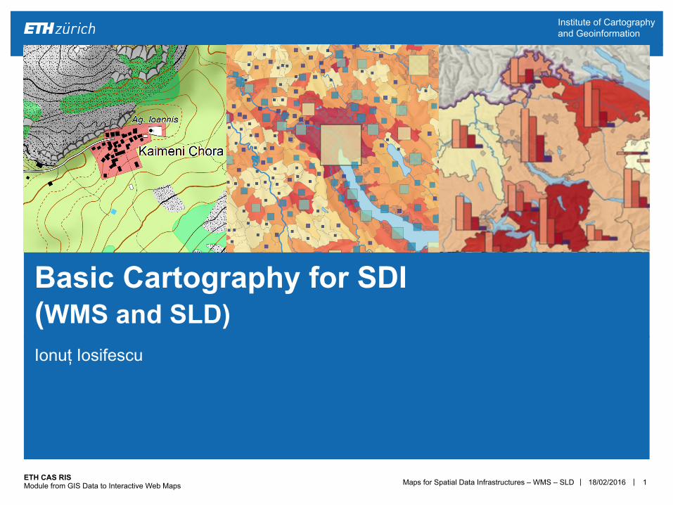
Ionuț Iosifescu
Basic Cartography for SDI (WMS and SLD)
18/02/2016
Maps for Spatial Data Infrastructures – WMS – SLD | | ETH CAS RIS Module from GIS Data to Interactive Web Maps
Institute of Cartography and Geoinformation
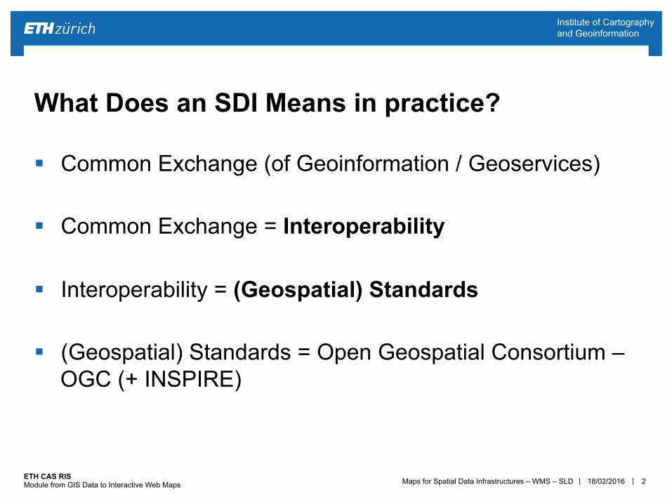
§ Common Exchange (of Geoinformation / Geoservices) § Common Exchange = Interoperability
§ Interoperability = (Geospatial) Standards
§ (Geospatial) Standards = Open Geospatial Consortium – OGC (+ INSPIRE)
2
What Does an SDI Means in practice?
18/02/2016
Maps for Spatial Data Infrastructures – WMS – SLD | | ETH CAS RIS Module from GIS Data to Interactive Web Maps
Institute of Cartography and Geoinformation
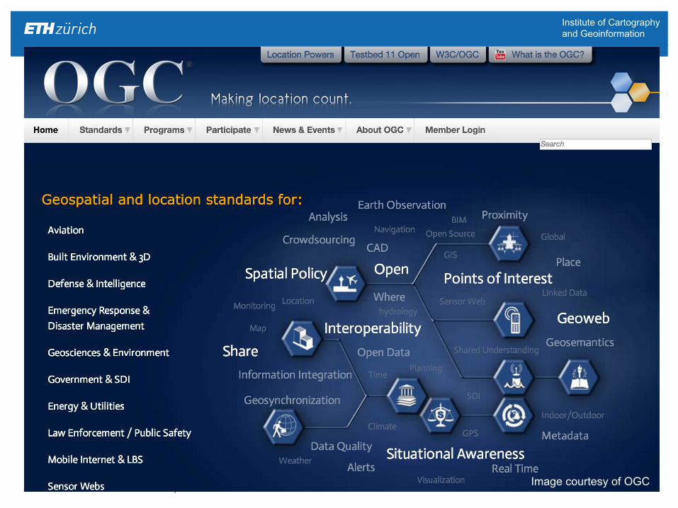
12/02/15 3 Image courtesy of OGC
Maps for Spatial Data Infrastructures – WMS – SLD | | ETH CAS RIS Module from GIS Data to Interactive Web Maps
Institute of Cartography and Geoinformation
§ Interoperability, at a technical level, refers to the ability of a system to provide information portability and inter-application as well as cooperative process control.
§ Interoperability, in the context of the OGC, is software components operating reciprocally (working with each other) to overcome import/export obstacles and distributed resource access barriers imposed by heterogeneous processing environments and heterogeneous data sources.
4
Interoperability
18/02/2016
Maps for Spatial Data Infrastructures – WMS – SLD | | ETH CAS RIS Module from GIS Data to Interactive Web Maps
Institute of Cartography and Geoinformation
5
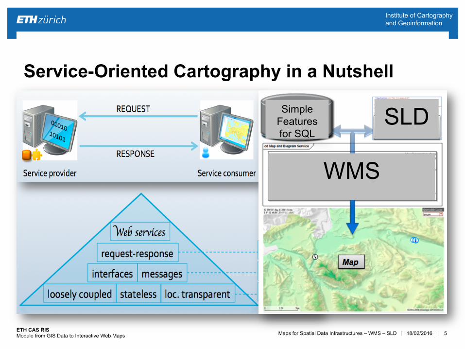
Service-Oriented Cartography in a Nutshell
WMS
SLD Simple Features for SQL
18/02/2016
Maps for Spatial Data Infrastructures – WMS – SLD | | ETH CAS RIS Module from GIS Data to Interactive Web Maps
Institute of Cartography and Geoinformation
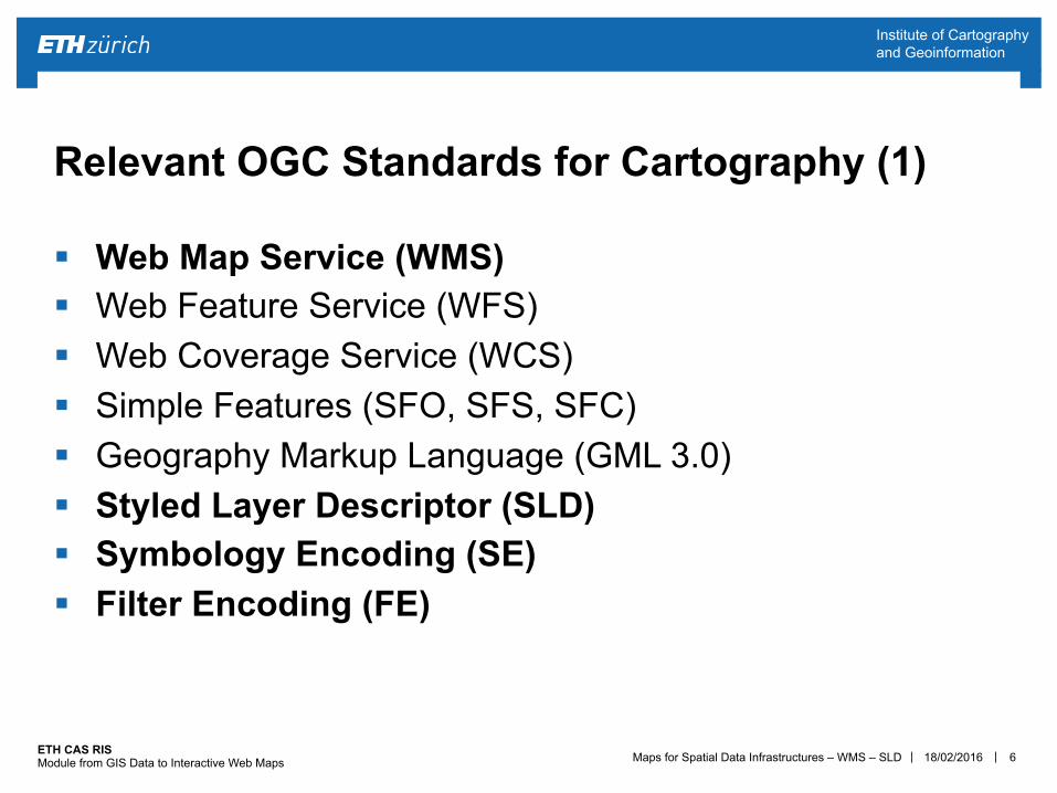
§ Web Map Service (WMS) § Web Feature Service (WFS) § Web Coverage Service (WCS) § Simple Features (SFO, SFS, SFC) § Geography Markup Language (GML 3.0) § Styled Layer Descriptor (SLD) § Symbology Encoding (SE) § Filter Encoding (FE)
6
Relevant OGC Standards for Cartography (1)
18/02/2016
Maps for Spatial Data Infrastructures – WMS – SLD | | ETH CAS RIS Module from GIS Data to Interactive Web Maps
Institute of Cartography and Geoinformation
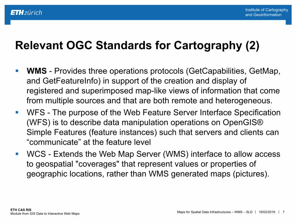
§ WMS - Provides three operations protocols (GetCapabilities, GetMap, and GetFeatureInfo) in support of the creation and display of registered and superimposed map-like views of information that come from multiple sources and that are both remote and heterogeneous.
§ WFS - The purpose of the Web Feature Server Interface Specification (WFS) is to describe data manipulation operations on OpenGIS® Simple Features (feature instances) such that servers and clients can “communicate” at the feature level
§ WCS - Extends the Web Map Server (WMS) interface to allow access to geospatial "coverages" that represent values or properties of geographic locations, rather than WMS generated maps (pictures).
7
Relevant OGC Standards for Cartography (2)
18/02/2016
Maps for Spatial Data Infrastructures – WMS – SLD | | ETH CAS RIS Module from GIS Data to Interactive Web Maps
Institute of Cartography and Geoinformation
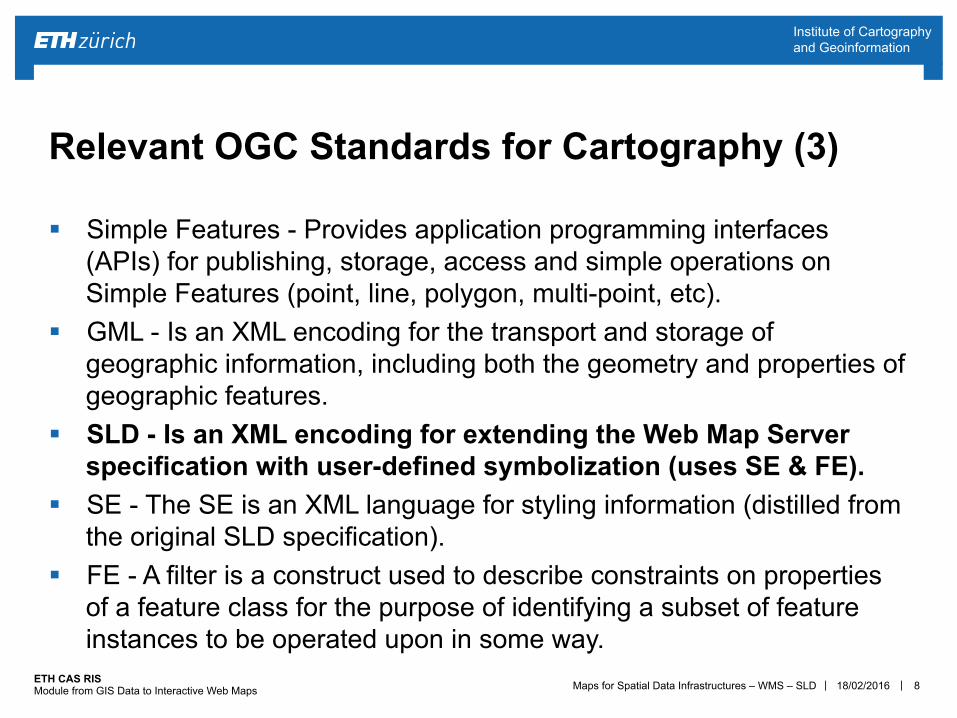
§ Simple Features - Provides application programming interfaces (APIs) for publishing, storage, access and simple operations on Simple Features (point, line, polygon, multi-point, etc).
§ GML - Is an XML encoding for the transport and storage of geographic information, including both the geometry and properties of geographic features.
§ SLD - Is an XML encoding for extending the Web Map Server specification with user-defined symbolization (uses SE & FE).
§ SE - The SE is an XML language for styling information (distilled from the original SLD specification).
§ FE - A filter is a construct used to describe constraints on properties of a feature class for the purpose of identifying a subset of feature instances to be operated upon in some way.
8
Relevant OGC Standards for Cartography (3)
18/02/2016
Maps for Spatial Data Infrastructures – WMS – SLD | | ETH CAS RIS Module from GIS Data to Interactive Web Maps
Institute of Cartography and Geoinformation
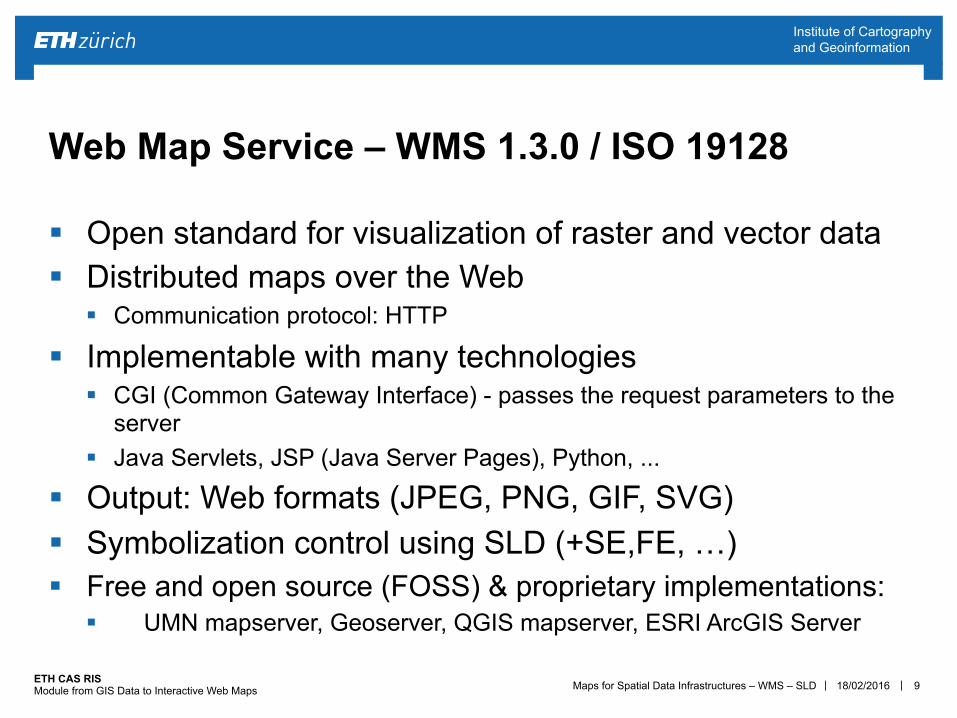
§ Open standard for visualization of raster and vector data § Distributed maps over the Web
§ Communication protocol: HTTP
§ Implementable with many technologies § CGI (Common Gateway Interface) - passes the request parameters to the
server § Java Servlets, JSP (Java Server Pages), Python, ...
§ Output: Web formats (JPEG, PNG, GIF, SVG) § Symbolization control using SLD (+SE,FE, …) § Free and open source (FOSS) & proprietary implementations:
§ UMN mapserver, Geoserver, QGIS mapserver, ESRI ArcGIS Server
9
Web Map Service – WMS 1.3.0 / ISO 19128
18/02/2016
Maps for Spatial Data Infrastructures – WMS – SLD | | ETH CAS RIS Module from GIS Data to Interactive Web Maps
Institute of Cartography and Geoinformation
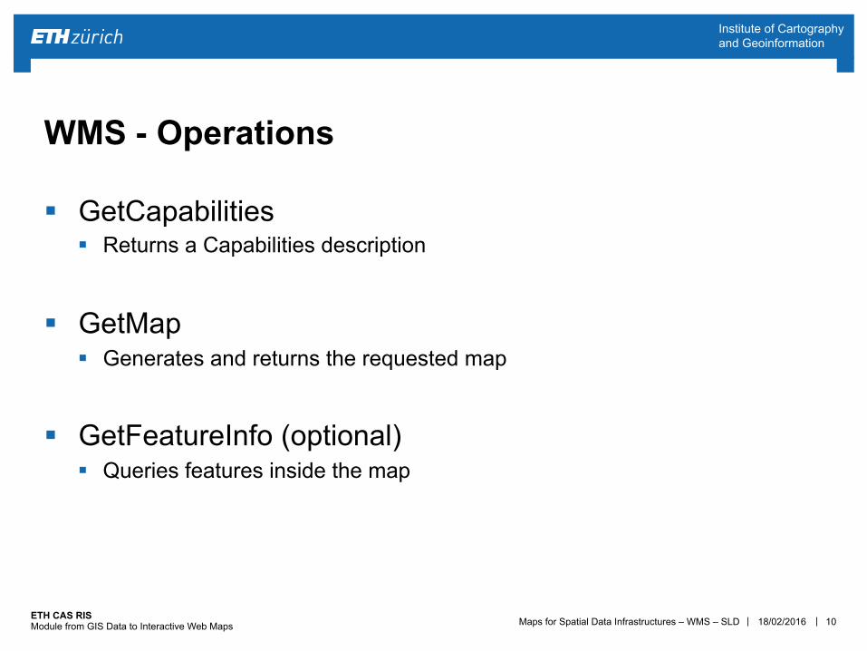
§ GetCapabilities § Returns a Capabilities description
§ GetMap § Generates and returns the requested map
§ GetFeatureInfo (optional) § Queries features inside the map
10
WMS - Operations
18/02/2016
Maps for Spatial Data Infrastructures – WMS – SLD | | ETH CAS RIS Module from GIS Data to Interactive Web Maps
Institute of Cartography and Geoinformation
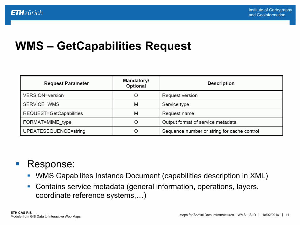
§ Response: § WMS Capabilites Instance Document (capabilities description in XML) § Contains service metadata (general information, operations, layers,
coordinate reference systems,…)
11
WMS – GetCapabilities Request
18/02/2016
Maps for Spatial Data Infrastructures – WMS – SLD | | ETH CAS RIS Module from GIS Data to Interactive Web Maps
Institute of Cartography and Geoinformation
12
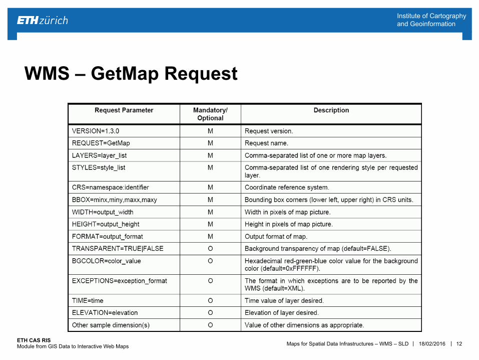
WMS – GetMap Request
18/02/2016
Maps for Spatial Data Infrastructures – WMS – SLD | | ETH CAS RIS Module from GIS Data to Interactive Web Maps
Institute of Cartography and Geoinformation
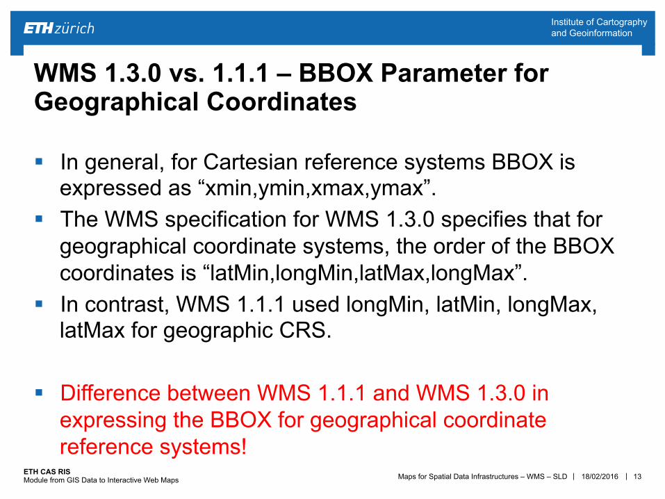
§ In general, for Cartesian reference systems BBOX is expressed as “xmin,ymin,xmax,ymax”.
§ The WMS specification for WMS 1.3.0 specifies that for geographical coordinate systems, the order of the BBOX coordinates is “latMin,longMin,latMax,longMax”.
§ In contrast, WMS 1.1.1 used longMin, latMin, longMax, latMax for geographic CRS.
§ Difference between WMS 1.1.1 and WMS 1.3.0 in
expressing the BBOX for geographical coordinate reference systems!
13
WMS 1.3.0 vs. 1.1.1 – BBOX Parameter for Geographical Coordinates
18/02/2016
Maps for Spatial Data Infrastructures – WMS – SLD | | ETH CAS RIS Module from GIS Data to Interactive Web Maps
Institute of Cartography and Geoinformation
14
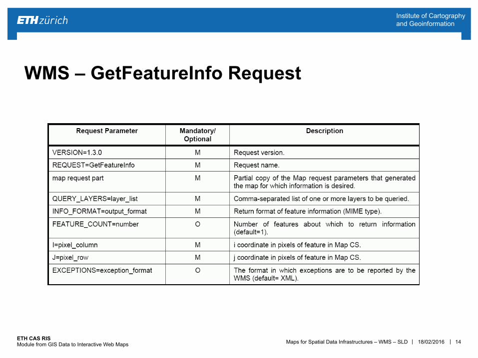
WMS – GetFeatureInfo Request
18/02/2016
Maps for Spatial Data Infrastructures – WMS – SLD | | ETH CAS RIS Module from GIS Data to Interactive Web Maps
Institute of Cartography and Geoinformation
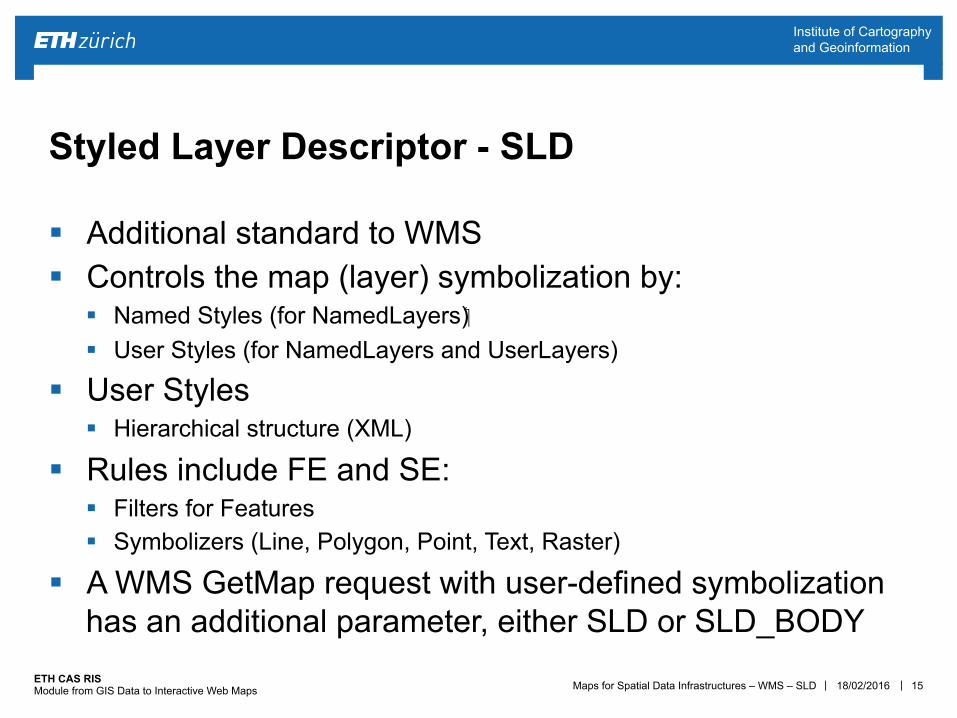
§ Additional standard to WMS § Controls the map (layer) symbolization by:
§ Named Styles (for NamedLayers) § User Styles (for NamedLayers and UserLayers)
§ User Styles § Hierarchical structure (XML)
§ Rules include FE and SE: § Filters for Features § Symbolizers (Line, Polygon, Point, Text, Raster)
§ A WMS GetMap request with user-defined symbolization has an additional parameter, either SLD or SLD_BODY
15
Styled Layer Descriptor - SLD
18/02/2016
Maps for Spatial Data Infrastructures – WMS – SLD | | ETH CAS RIS Module from GIS Data to Interactive Web Maps
Institute of Cartography and Geoinformation
16
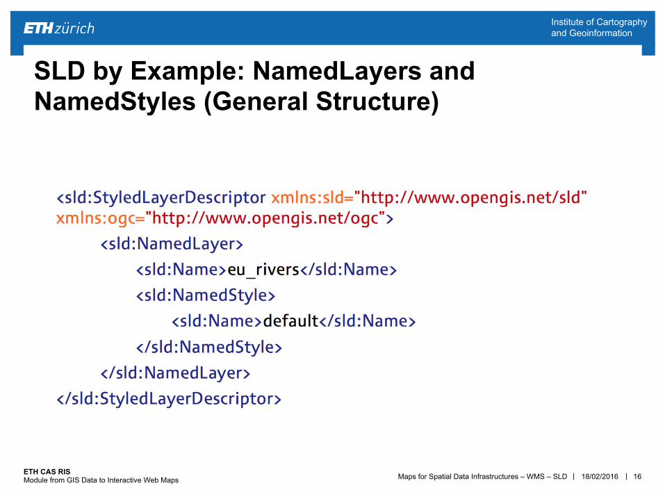
SLD by Example: NamedLayers and NamedStyles (General Structure)
18/02/2016
Maps for Spatial Data Infrastructures – WMS – SLD | | ETH CAS RIS Module from GIS Data to Interactive Web Maps
Institute of Cartography and Geoinformation
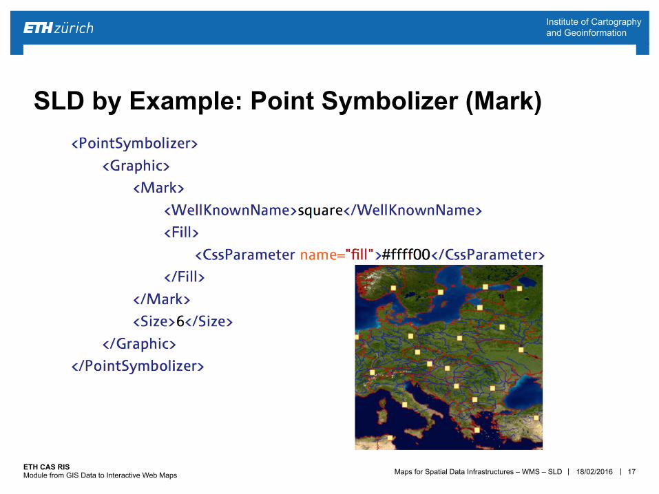
17
SLD by Example: Point Symbolizer (Mark)
18/02/2016
Maps for Spatial Data Infrastructures – WMS – SLD | | ETH CAS RIS Module from GIS Data to Interactive Web Maps
Institute of Cartography and Geoinformation
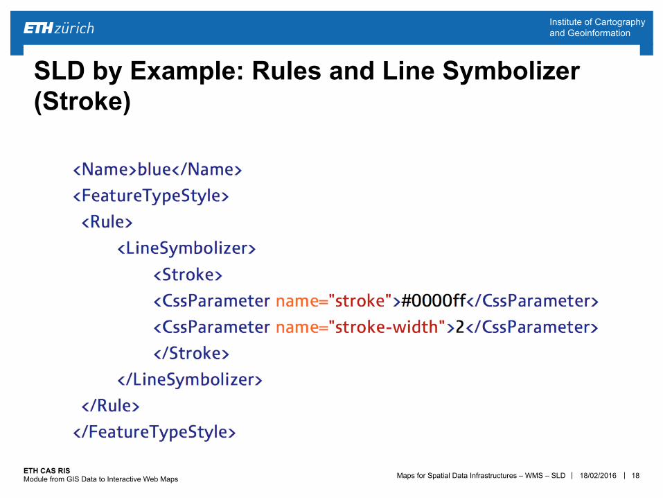
18
SLD by Example: Rules and Line Symbolizer (Stroke)
18/02/2016
Maps for Spatial Data Infrastructures – WMS – SLD | | ETH CAS RIS Module from GIS Data to Interactive Web Maps
Institute of Cartography and Geoinformation
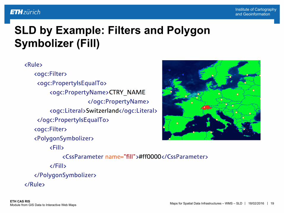
19
SLD by Example: Filters and Polygon Symbolizer (Fill)
18/02/2016
Maps for Spatial Data Infrastructures – WMS – SLD | | ETH CAS RIS Module from GIS Data to Interactive Web Maps
Institute of Cartography and Geoinformation
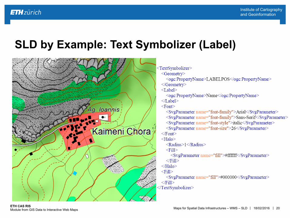
20
SLD by Example: Text Symbolizer (Label)
18/02/2016
Maps for Spatial Data Infrastructures – WMS – SLD | | ETH CAS RIS Module from GIS Data to Interactive Web Maps
Institute of Cartography and Geoinformation
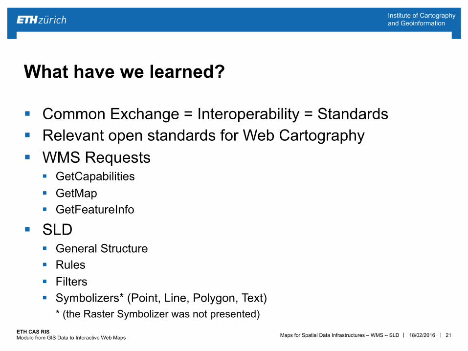
§ Common Exchange = Interoperability = Standards § Relevant open standards for Web Cartography § WMS Requests
§ GetCapabilities § GetMap § GetFeatureInfo
§ SLD § General Structure § Rules § Filters § Symbolizers* (Point, Line, Polygon, Text)
* (the Raster Symbolizer was not presented)
21
What have we learned?
18/02/2016
Maps for Spatial Data Infrastructures – WMS – SLD | | ETH CAS RIS Module from GIS Data to Interactive Web Maps
Institute of Cartography and Geoinformation
? 22
Questions
18/02/2016
Maps for Spatial Data Infrastructures – WMS – SLD | | ETH CAS RIS Module from GIS Data to Interactive Web Maps
Institute of Cartography and Geoinformation
§ WMS and SLD: § Understand the WMS protocol § Customize the generated SLD from admin.sld § Integrate the WMS layers into your Leaflet map
23
Exercise 6
18/02/2016