Embed Size (px)
Citation preview
i
Baseline survey of benthic marine communities of Cape Preston
and Preston Island
Campey1 ML, JP Gilmour2 1 Botany Department, University of Western Australia, Nedlands, W.A. 6907, Australia 2 Zoology Department, University of Western Australia, Nedlands, W.A. 6907, Australia
May 2000
Prepared for Halpern Glick Maunsell Pty Ltd
ii
Table of Contents
1. Executive Summary 1
2. Introduction 3
3. Materials and Methods 4
3.1 Survey area 4
3.2 Survey techniques 4
3.3 Habitat map 5
3.4 Species list 5
4. Results 6
4.1 Description of substrata and habitat types 6
1) Bare sand 6
2) Sand / algae 6
3) Sparse coral / mixed algae / sponges / sand / rubble 7
4) Medium coral cover / mixed algae 11
5) High coral cover / mixed algae 14
6) Sand and silt 15
4.2 Habitat map 15
4.3 Species list 16
5. Discussion 19
6. References 22
Appendix 1. Percent cover for each general category, family and genus analysed
using video transect
iii
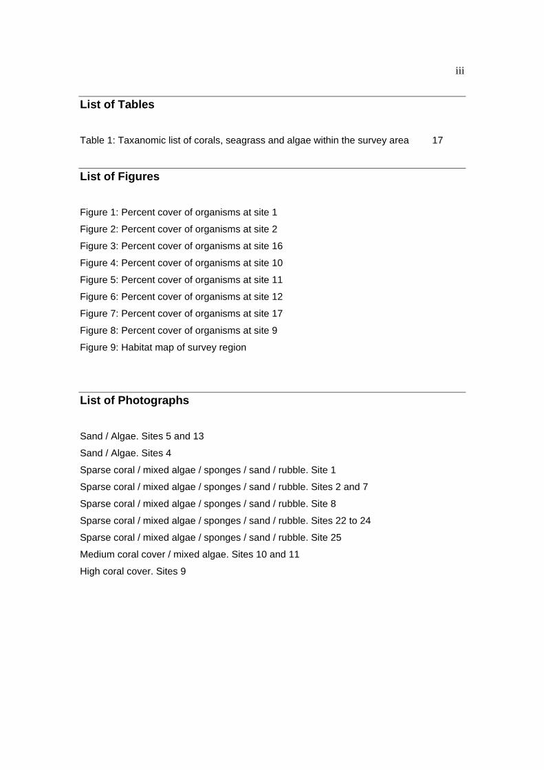
List of Tables
Table 1: Taxanomic list of corals, seagrass and algae within the survey area 17
List of Figures
Figure 1: Percent cover of organisms at site 1
Figure 2: Percent cover of organisms at site 2
Figure 3: Percent cover of organisms at site 16
Figure 4: Percent cover of organisms at site 10
Figure 5: Percent cover of organisms at site 11
Figure 6: Percent cover of organisms at site 12
Figure 7: Percent cover of organisms at site 17
Figure 8: Percent cover of organisms at site 9
Figure 9: Habitat map of survey region
List of Photographs
Sand / Algae. Sites 5 and 13
Sand / Algae. Sites 4
Sparse coral / mixed algae / sponges / sand / rubble. Site 1
Sparse coral / mixed algae / sponges / sand / rubble. Sites 2 and 7
Sparse coral / mixed algae / sponges / sand / rubble. Site 8
Sparse coral / mixed algae / sponges / sand / rubble. Sites 22 to 24
Sparse coral / mixed algae / sponges / sand / rubble. Site 25
Medium coral cover / mixed algae. Sites 10 and 11
High coral cover. Sites 9
1
1. Executive Summary
A survey of benthic marine communities was conducted around the northern part of
Cape Preston and around Preston Island. Sampling within the survey region was
stratified along four transects perpendicular to Cape Preston and around Preston Island.
Three different methods were used to describe the communities at each site depending
on the abundance and diversity of constituent species. The community assemblage at
each site was then used to produce six general habitat types within the region that are
representative of near-shore communities found along the Pilbara coast. A species list of
coral and algae for the region was also compiled.
The tip of Cape Preston is typical of exposed rocky shore environments in the tropics.
This habitat type extends from the cape shore for approximately 100m. There is a high
abundance and diversity of algae dominated by Sargassum spp. (~ 25%). There is also
a high diversity of other benthic invertebrates including sponges, zoanthids, ascidians
and soft corals in low abundance. Coral cover is low and characteristic of this
environment, largely consisting of Turbinaria sp., and Favids.
A habitat consisting mainly of sand and algae extends from the top of Cape Preston,
south to Preston spit. This community consists mainly of Sargassum spp. in variable
abundance (5 - 50%) with other associated algae and some benthic invertebrates.
Beyond the sand and algae strip is a diverse habitat consisting of algae, hard coral, soft
corals, sponges and other benthic invertebrates. The increase in organisms here reflects
the increase in hard substrata for settlement. Algae is dominant in this region (~ 30%)
and coral cover is low (<10%) but there is a wide diversity of benthic organisms present.
Many colonies are large and old indicating that the area provides a suitable habitat but
that reef formation is limited by substrata availability.
In the northern region of Cape Preston and around Preston Island is a strip of coral reef
with high coral cover (~ 30%) and diversity. Algae are in low abundance (<10%) and
benthic invertebrate communities are typical of near-shore reefs, including sponges soft
corals and ascidians. Representative coral species generally fall within the families
Dedrophyllidae, Faviidae and Acroporidae. Associated with these reefs is a region of
2
high coral cover and very high species diversity on the northern side of Preston Island.
This region is more characteristic of mid- to outer-coral reef environments and may
provide a valuable source of coral recruits for connected communities.
Extending beyond these regions is a habitat type consisting of sand and silt with benthic
biota consisting of occasional sponges, ascidians and gorgonians.
3
2. Introduction
This study was commissioned to provide baseline marine biological data of Cape
Preston before the establishment of an export facility for hot briquetted iron and steel.
The objective of the survey was to quantify and map dominant benthic habitat types for
future assessment of potential impacts following development. A list of coral and algae
species observed within the survey area has also been produced. Coral species
distributions for Western Australia have been published by Veron and Marsh (1988)
while the tropical algal records for Australia have been systematically listed by Lewis
(Rhodophyta:1984, Phaeopyta:1985, Chlorophyta:1986). Other studies of tropical marine
algae from north Western Australia include a detailed account of benthic marine flora of
the Dampier Archipelago, north-east of Cape Preston, in the Pilbara region by
Borowitzka and Huisman (unpublished). A list of the corals and some associated
invertebrates of the Dampier Archipelago was published by Marsh (1978). To date many
surveys of the marine flora and fauna of north Western Australia are restricted to species
lists and short site descriptions. Quantification of abundance of species that together
characterise typical communities is rare or restricted to grey literature.
4
3. Materials and Methods
3.1 Survey area
Cape Preston is located approximately 80 km south west of Karratha in the Pilbara
region of Western Australia. The marine survey encompassed the area north from
Preston Spit to the tip of Cape Preston, and included Preston Island. The survey area
extended from the intertidal shoreline to the 12m depth contour. Site locations are
displayed on the habitat (Figure 9).
3.2 Survey techniques
Aerial photographs and bathymetric charts of the Cape Preston region were studied in
order to develop a survey strategy. The choice of survey sites was stratified to provide a
representative selection of habitats. Sites were distributed among six main regions:
1. tip of Cape Preston;
2. transect I. from the tip of the cape to Preston Island;
3. Preston Island;
4. transect II. perpendicular to Cape Preston and 400 meters south of the tip;
5. transect III. perpendicular to Cape Preston and 2400 meters south of the tip;
6. transect IV. along Preston spit perpendicular to the shore.
Three different survey techniques were used depending on the abundance and diversity
of organisms observed at each site. Spot dives were used only when the numbers of
organisms present were low (e.g. bare sand sites), or when the community assemblage
was easily allocated to a habitat type that had already been investigated using a more
detailed method of assessment. Qualitative measures of community assemblage were
made by counting the numbers or estimating the percent cover of dominant organisms
within an area of 50 x 5m swum on snorkel. This method was also used mainly when
abundance or diversity of organisms was low and the site was characteristic of
established habitat types. In any survey it is necessary to use quantitative methods to
provide accurate and comparative results that underlie the habitat descriptions. When
abundance and diversity of organisms at a site was comparatively high, video transect
analysis was employed to quantify the community assemblage. The point intercept
method of determining percent cover for the dominant benthic organisms was used
5
according to methods adapted by the Australia Institute of Marine Science (Christie et al.
1996). Transects (50m) were laid at a total of six sites and video footage taken according
to the above methods.
3.3 Habitat map
Coordinates of each survey site were collected using a global positioning system. The
accuracy of these instruments is typically quoted as within 20m. Each site was placed
into one of six habitat types characteristic of the survey area. Using percent cover and
species diversity information from each site a general community assemblage was
created for each habitat type. More detailed descriptions for each site in each habitat
type were also included in the results. This data was extrapolated to create a broad
habitat diagram for the survey region.
3.4 Species List
A list of coral and algal species within each habitat was made as a measure of
distribution and diversity that could be compared with other geographic regions along the
Pilbara. Algae were identified using Huisman J.M. and Walker D.I. (1990) and
Borowitzka and Huisman (Unpublished). The identification of coral species was based
on morphology, habitat and regional distribution using Marsh (1978), Veron and Marsh
(1988), Veron (1993) and Wolstenholme (1998).
6
4. Results
4.1 Description of substrata and habitat types
Six dominant habitat types were identified within the survey area, that ranged in depth
from 0 – 12 m. These habitat types are representative of shallow benthic communities
located along the Pilbara coast. The general characteristics of each habitat are
described below in terms of substratum, dominant flora and faunal composition. Within
each habitat type individual sites have been allocated, and a more detailed description of
each of these has been included following the general summary. Graphs of the percent
cover of each category or dominant genera, for each site quantified using video
techniques, are located at the end of their relevant habitat types. Photographs of
characteristic habitat types are also included.
1) Bare sand
Much of the shallow and intertidal areas along the shoreline, including Preston Spit, were
characterised by calcareous sand. No benthic macrophytes or corals were observed in
this habitat. [Sites: 18, 19, 20, 26, 27, 28, 29, 30]
Site 18 to 20 - Transect III: 50m - 450m offshore
These sites consist almost entirely of sand, with little rubble or algal cover
observed.
Site 26 to 30 – Transect IV (Preston Spit): 100m - 2000m west of Spit
These sites cover the western extension of Preston Spit and are composed
entirely of sand. No algae or other benthic organisms were observed at these sites.
2) Sand / algae
This habitat type was characterised by a sandy bottom with some rubble and algal cover.
Sargassum spp. are the dominant macroalgae, with percent cover varying between the
sites (5 – 50%). Sparse algal cover (<10%) was found in the deeper areas between
Cape Preston and Preston Island. Higher cover of algae was observed at near-shore
sites and those surrounding Preston Spit. Species of Halimeda, Padina, Laurencia,
7
Dictyota and Codium were also present at much lower densities. [Sites: 4, 5, 13, 14, 15,
21, 31, 32]
Site 4 - Transect I (Cape to Island): 200m offshore.
Sandy bottom characterised by Sargassum spp. and sparse distribution of large
erect sponges, soft corals, and large established coral colonies (Turbinaria sp. Poritids
Favids and occasional Acroporids).
Site 5 - Transect I (Cape to Island): 500m offshore.
Half way between mainland and Preston Island and similar to Site 4.
Predominately sand and Sargassum spp. (~30 - 50%) cover. Corals, soft corals and
sponges of similar diversity and size structure to Site 4. but in lower density.
Sites 13 to 15 - Transect II: 100m - 400m offshore
The substrata at these sites consist of sand and rubble. Sargassum spp. are by
far the dominant organisms having approximately 25 - 50% cover. Other algae genera
include Padina, Halimeda, Bornetella, Galaxaura and branching and encrusting coralline
algae.
Site 21 - Transect III: 650m offshore
The substrata here is predominantly sand although rubble is becoming more
common. There is sparse algal cover (5 - 10%) related to the presence of hard substrata
which mostly consists of Sargassum spp. This site is similar to the near-shore Sites 13 -
15.
Sites 31 to 32- Transect: IV (Preston Spit) 2200 - 3000m west of Spit
These sites are characterised by small patches of hard substrata with medium
cover of Sargassum spp. (~ 25%). Sand is still the dominant substrata type although
some rubble is present. West of Site 32 substrata becomes sand again with no
associated benthic communities.
3) Sparse coral / mixed algae / sponges / sand / rubble
Generally a low coral cover of <10% with low diversity, dominated by a few common
species. In particular, representatives of the genus Turbinaria, Porites, Goniastrea and
8
Favites were most abundant in these areas. Algae are the most common component of
these areas generally occupying between 30 - 50% of the substrata. Macroalgae of the
genus Sargassum was spatially dominant covering approximately 25% of the substrata
while the members of the genera Padina and Halimeda were also common. Species of
Caulerpa, Bornetella, Galaxaura, Amphiroa, Lobophora, Dictyota and Hormophysa were
also present. A single occurrence of Syringodium isoetifolium was observed near the
cape, however this was the only seagrass sited within the study area. A variety of erect
and encrusting sponges occupied small area of the substrata (< 5%) and despite having
a high species diversity were generally dominated by a few common genera including,
Verongula, Ianthella, Carteriospongia, Dysidea, Tethya, Haliclona, Callyspongia,
Leuclonia and Jaspis. A variety of other benthic invertebrates were present in this
habitat type including ascidians, soft corals, gorgonians, hydrozoans and marine worms.
Percent cover was very low in the deeper sites where gorgonians and sponges were the
dominant organisms. [Sites:1, 2, 3, 6, 7, 8, 16, 22, 23, 24, 25]
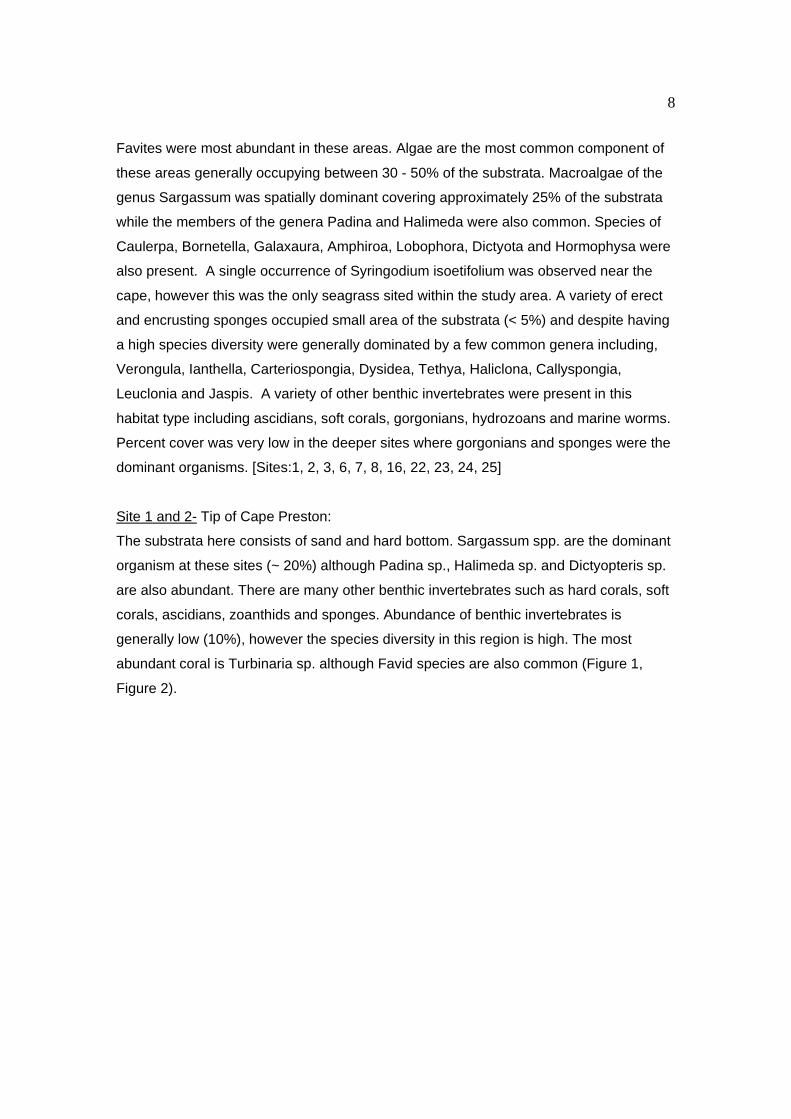
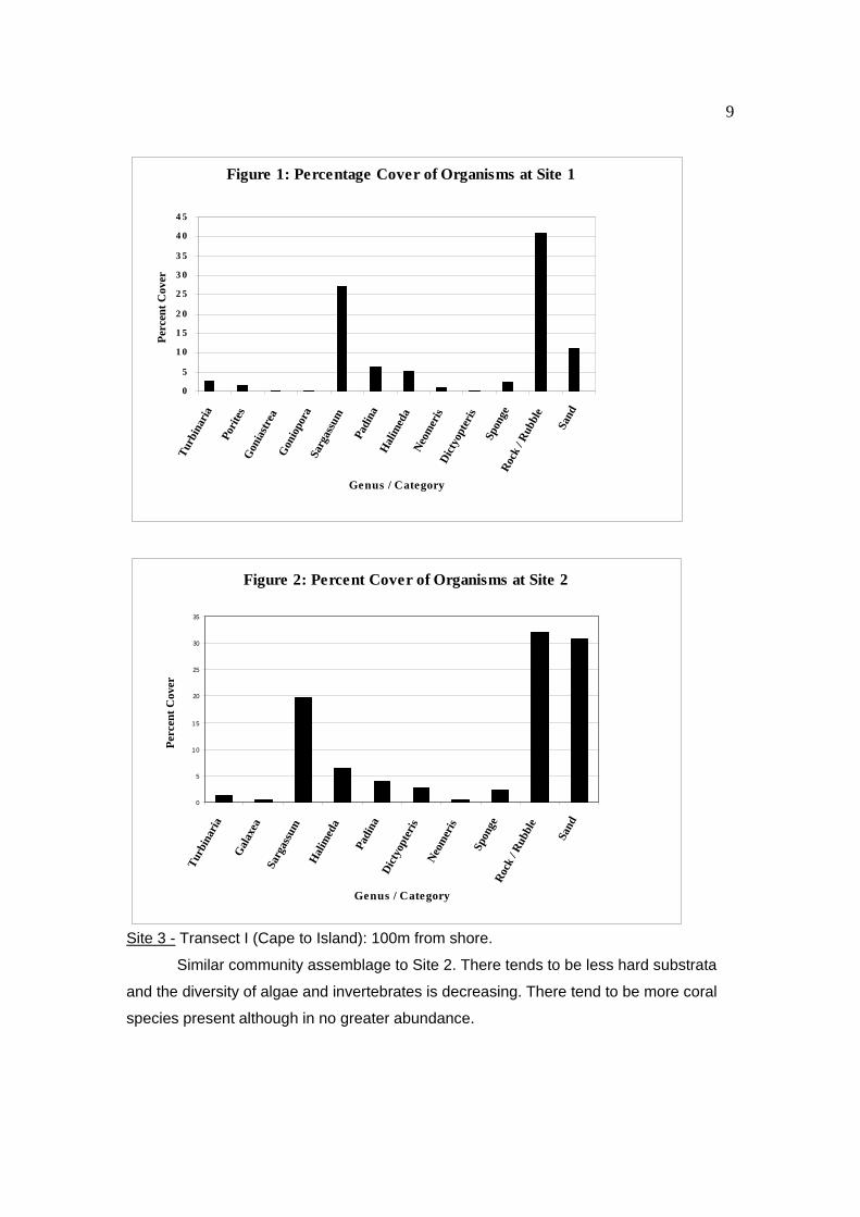
Site 1 and 2- Tip of Cape Preston:
The substrata here consists of sand and hard bottom. Sargassum spp. are the dominant
organism at these sites (~ 20%) although Padina sp., Halimeda sp. and Dictyopteris sp.
are also abundant. There are many other benthic invertebrates such as hard corals, soft
corals, ascidians, zoanthids and sponges. Abundance of benthic invertebrates is
generally low (10%), however the species diversity in this region is high. The most
abundant coral is Turbinaria sp. although Favid species are also common (Figure 1,
Figure 2).
9
Site 3 - Transect I (Cape to Island): 100m from shore.
Similar community assemblage to Site 2. There tends to be less hard substrata
and the diversity of algae and invertebrates is decreasing. There tend to be more coral
species present although in no greater abundance.
Figure 1: Percentage Cover of Organisms at Site 1
0
5
1 0
1 5
2 0
2 5
3 0
3 5
4 0
4 5
Turb
inar
ia
Pori
tes
Gon
iast
rea
Gon
iopo
raSa
rgas
sum
Padi
naH
alim
eda
Neo
mer
isD
icty
opte
ris
Spon
geR
ock
/ Rub
ble
Sand
Genus / Category
Per
cent
Cov
er
Figure 2: Percent Cover of Organisms at Site 2
0
5
10
15
20
25
30
35
Turb
inar
ia
Gal
axea
Sarg
assu
m
Hal
imed
a
Padi
naD
icty
opte
ris
Neo
mer
is
Spon
geR
ock
/ Rub
ble
Sand
Genus / Category
Per
cent
Cov
er
10
Site 6. - Transect I: 400m from Preston Island
Sand and Sargassum spp. dominate but substrata becoming harder with more
rubble. Reflecting substrata shift is a change in algal cover, including Halimeda and
Padina. Increases in hard corals, soft corals and sponge cover similar to those at Sites 4
and 5 but in higher abundance. Branching Acroporid corals also becoming common.
Site 7. - Preston Island: Southern tip of Preston Is.
Substrata consists of sand and rubble. Sargassum spp. dominate the algae
(~30%) but Halimeda and Padina also common. Diversity and cover of coral reasonably
high when compared to Sites 4, 5 and 6, with numerous small to large colonies.
Turbinaria sp. is again by far the dominant coral species but Favids, Poritids and
Acroporids are also common.
Site 8. - Preston Island: South-Eastern Bay 100m from Preston Is.
Substrata consists of sand and rubble with similar algal cover to Site 6. Medium
to large colonies of the soft coral Lobophyton sp. are abundant in this bay, most likely
reflecting a long history of asexual propagation.
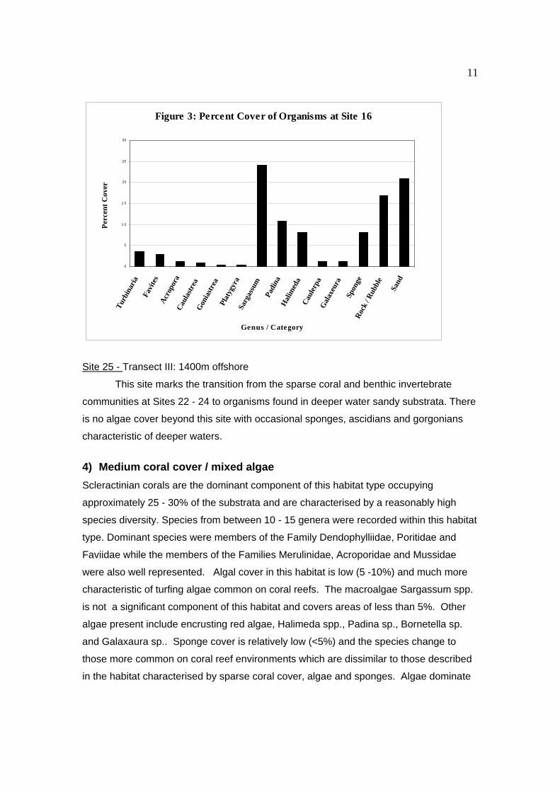
Sites 16 - Transect II: 800m offshore
This site marks the change from a zone dominated by Sargassum spp. to a
community characterised by a variety of hard corals, soft corals, sponges and other
benthic organisms. Algae such as Halimeda sp. and Padina sp. are more common at
this site. Coral cover is relatively low and dominated by Turbinaria spp. or occasional
large Favid and Acropora colonies (Figure 3).
Sites 22 to 24 - Transect III: 800m to 1200m offshore.
Patches of hard substrata become more common at these sites. There is a low
cover of Sargassum spp. (~ 5%) which occurs with Padina spp. and Halimeda spp.
There is an increase in hard coral, soft coral and sponge cover at these sites although
their distribution is largely constrained by the limited amount of hard substrata relative to
sand. Coral colonies are generally old with Turbinaria sp. and large Poritid and Favid
colonies most common. Other benthic invertebrates are also present. Site 22 marks the
transition from a zone dominated by sand and low algal cover to a sparse community of
corals and sponges, and thus is comparable to Site 16 in Transect II.
11
Site 25 - Transect III: 1400m offshore
This site marks the transition from the sparse coral and benthic invertebrate
communities at Sites 22 - 24 to organisms found in deeper water sandy substrata. There
is no algae cover beyond this site with occasional sponges, ascidians and gorgonians
characteristic of deeper waters.
4) Medium coral cover / mixed algae
Scleractinian corals are the dominant component of this habitat type occupying
approximately 25 - 30% of the substrata and are characterised by a reasonably high
species diversity. Species from between 10 - 15 genera were recorded within this habitat
type. Dominant species were members of the Family Dendophylliidae, Poritidae and
Faviidae while the members of the Families Merulinidae, Acroporidae and Mussidae
were also well represented. Algal cover in this habitat is low (5 -10%) and much more
characteristic of turfing algae common on coral reefs. The macroalgae Sargassum spp.
is not a significant component of this habitat and covers areas of less than 5%. Other
algae present include encrusting red algae, Halimeda spp., Padina sp., Bornetella sp.
and Galaxaura sp.. Sponge cover is relatively low (<5%) and the species change to
those more common on coral reef environments which are dissimilar to those described
in the habitat characterised by sparse coral cover, algae and sponges. Algae dominate
Figure 3: Percent Cover of Organisms at Site 16
0
5
1 0
1 5
20
25
30
Tur
bina
ria
Favi
tes
Acr
opor
aC
aula
stre
aG
onia
stre
aPl
atyg
yra
Sarg
assu
m
Padi
naH
alim
eda
Cau
lerp
aG
alax
eura
Spon
geR
ock
/ Rub
ble
Sand
Genus / Category
Per
cent
Cov
er
12
at shallower depths of this habitat and changes to a higher proportion of coral cover in
deeper water. [Sites: 10, 11, 12, 17]
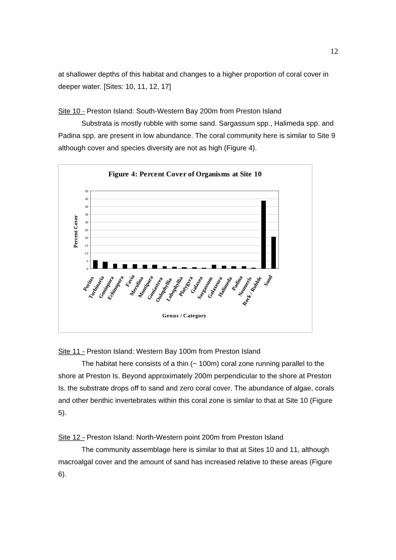
Site 10 - Preston Island: South-Western Bay 200m from Preston Island
Substrata is mostly rubble with some sand. Sargassum spp., Halimeda spp. and
Padina spp. are present in low abundance. The coral community here is similar to Site 9
although cover and species diversity are not as high (Figure 4).
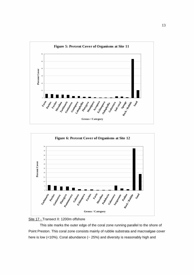
Site 11 - Preston Island: Western Bay 100m from Preston Island
The habitat here consists of a thin (~ 100m) coral zone running parallel to the
shore at Preston Is. Beyond approximately 200m perpendicular to the shore at Preston
Is. the substrate drops off to sand and zero coral cover. The abundance of algae, corals
and other benthic invertebrates within this coral zone is similar to that at Site 10 (Figure
5).
Site 12 - Preston Island: North-Western point 200m from Preston Island
The community assemblage here is similar to that at Sites 10 and 11, although
macroalgal cover and the amount of sand has increased relative to these areas (Figure
6).
Figure 4: Percent Cover of Organisms at Site 10
0
5
10
15
20
25
30
35
40
45
50
Pori
tes
Tur
bina
ria
Gon
iopo
raEc
hino
pora
Favi
aM
erul
ina
Mon
tipor
aG
onia
stre
aO
ulop
hylli
aLo
boph
yllia
Plat
ygyr
aG
alax
eaSa
rgas
sum
Gal
axeu
raH
alim
eda
Padi
naN
eom
eris
Roc
k / R
ubbl
eSa
nd
Genus / Category
Per
cent
Cov
er
13
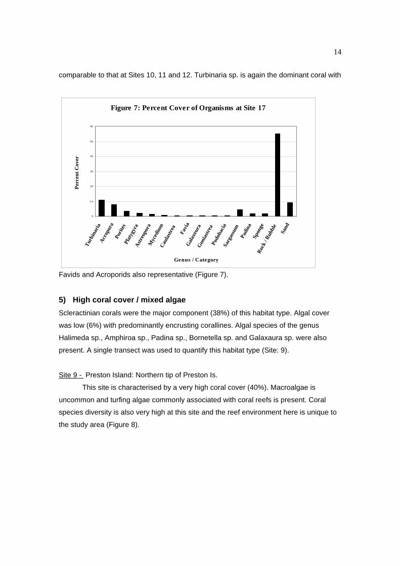
Site 17 - Transect II: 1200m offshore
This site marks the outer edge of the coral zone running parallel to the shore of
Point Preston. This coral zone consists mainly of rubble substrata and macroalgae cover
here is low (<10%). Coral abundance (~ 25%) and diversity is reasonably high and
Figure 5: Percent Cover of Organisms at Site 11
0
1 0
20
30
40
50
60
Favi
aPo
rite
sFa
vite
sM
erul
ina
Turb
inar
iaG
onia
stre
aG
onio
pora
Lobo
phyl
liaPl
atyg
yra
Mon
tipor
aA
crop
ora
Echi
nopo
raO
ulop
hylli
aG
alax
eura
Soft
cora
lSp
onge
Roc
k / R
ubbl
eSa
nd
Genus / Category
Per
cent
Cov
er
Figure 6: Percent Cover of Organisms at Site 12
0
5
1 0
1 5
20
25
30
35
40
45
50
Tur
bina
ria
Pori
tes
Gon
iast
rea
Plat
ygyr
aPs
amm
ocor
aG
alax
eaEc
hino
pora
Favi
tes
Favi
aM
erul
ina
Podo
baci
aG
alax
eura
Sarg
assu
mPa
dina
Roc
k / R
ubbl
e
Sand
Genus / Category
Per
cent
Cov
er
14
comparable to that at Sites 10, 11 and 12. Turbinaria sp. is again the dominant coral with
Favids and Acroporids also representative (Figure 7).
5) High coral cover / mixed algae
Scleractinian corals were the major component (38%) of this habitat type. Algal cover
was low (6%) with predominantly encrusting corallines. Algal species of the genus
Halimeda sp., Amphiroa sp., Padina sp., Bornetella sp. and Galaxaura sp. were also
present. A single transect was used to quantify this habitat type (Site: 9).
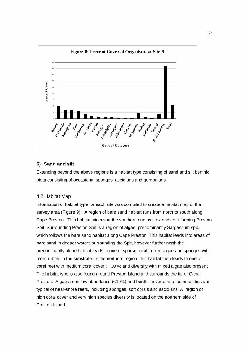
Site 9 - Preston Island: Northern tip of Preston Is.
This site is characterised by a very high coral cover (40%). Macroalgae is
uncommon and turfing algae commonly associated with coral reefs is present. Coral
species diversity is also very high at this site and the reef environment here is unique to
the study area (Figure 8).
Figure 7: Percent Cover of Organisms at Site 17
0
1 0
20
30
40
50
60
Turb
inar
iaA
crop
ora
Pori
tes
Plat
ygyr
aA
stre
opor
aM
yced
ium
Cau
last
rea
Favi
aG
alax
eura
Gon
iast
rea
Podo
baci
aSa
rgas
sum
Padi
naSp
onge
Roc
k / R
ubbl
e
Sand
Genus / Category
Per
cent
Cov
er
15
6) Sand and silt
Extending beyond the above regions is a habitat type consisting of sand and silt benthic
biota consisting of occasional sponges, ascidians and gorgonians.
4.2 Habitat Map
Information of habitat type for each site was compiled to create a habitat map of the
survey area (Figure 9). A region of bare sand habitat runs from north to south along
Cape Preston. This habitat widens at the southern end as it extends out forming Preston
Spit. Surrounding Preston Spit is a region of algae, predominantly Sargassum spp.,
which follows the bare sand habitat along Cape Preston. This habitat leads into areas of
bare sand in deeper waters surrounding the Spit, however further north the
predominantly algae habitat leads to one of sparse coral, mixed algae and sponges with
more rubble in the substrate. In the northern region, this habitat then leads to one of
coral reef with medium coral cover (~ 30%) and diversity with mixed algae also present.
The habitat type is also found around Preston Island and surrounds the tip of Cape
Preston. Algae are in low abundance (<10%) and benthic invertebrate communities are
typical of near-shore reefs, including sponges, soft corals and ascidians. A region of
high coral cover and very high species diversity is located on the northern side of
Preston Island.
Figure 8: Percent Cover of Organisms at Site 9
0
5
1 0
1 5
20
25
30
35
40
45
Pori
tes
Tur
bina
ria
Mon
tipor
aFa
via
Gon
iast
rea
Acr
opor
aFa
vite
sPl
atyg
yra
Lobo
phyl
liaA
stre
opor
aEc
hino
pora
Gal
axea
Sarg
assu
mPa
dina
Hal
imed
aSp
onge
Roc
k / R
ubbl
eSa
nd
Genus / Category
Per
cent
Cov
er
16
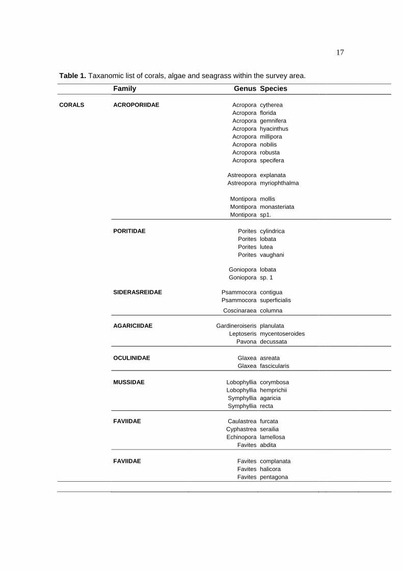
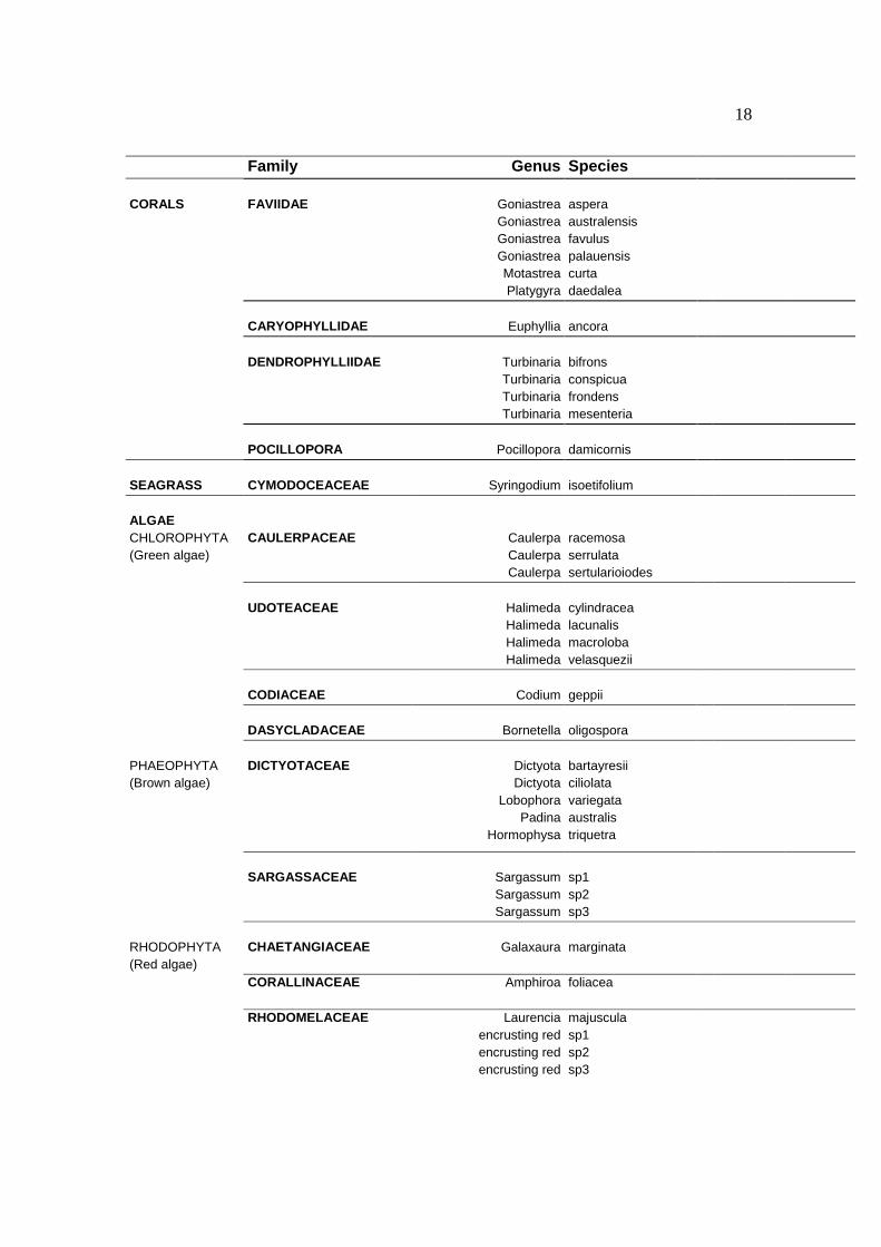
4.3 Species list
Species from each site were recorded to compile a species list for the survey area
(Table 1). Fifty species of corals were recorded from 11 families. Green (Chlorophyta),
brown (Phaeophyta) and red (Rhodophyta) algae were reported within the survey area.
Only one isolated siting of seagrass, Syringodium isoetifolium, consisting of a few
shoots, was reported for the survey area.
17
Table 1. Taxanomic list of corals, algae and seagrass within the survey area.
Family Genus Species CORALS ACROPORIIDAE Acropora cytherea Acropora florida Acropora gemnifera Acropora hyacinthus Acropora millipora Acropora nobilis Acropora robusta Acropora specifera Astreopora explanata Astreopora myriophthalma Montipora mollis Montipora monasteriata Montipora sp1. PORITIDAE Porites cylindrica Porites lobata Porites lutea Porites vaughani Goniopora lobata Goniopora sp. 1 SIDERASREIDAE Psammocora contigua Psammocora superficialis
Coscinaraea columna AGARICIIDAE Gardineroiseris planulata Leptoseris mycentoseroides Pavona decussata OCULINIDAE Glaxea asreata Glaxea fascicularis MUSSIDAE Lobophyllia corymbosa Lobophyllia hemprichii Symphyllia agaricia Symphyllia recta FAVIIDAE Caulastrea furcata Cyphastrea serailia Echinopora lamellosa Favites abdita FAVIIDAE Favites complanata Favites halicora Favites pentagona
18
Family Genus Species CORALS FAVIIDAE Goniastrea aspera Goniastrea australensis Goniastrea favulus Goniastrea palauensis Motastrea curta Platygyra daedalea CARYOPHYLLIDAE Euphyllia ancora DENDROPHYLLIIDAE Turbinaria bifrons Turbinaria conspicua Turbinaria frondens Turbinaria mesenteria POCILLOPORA Pocillopora damicornis SEAGRASS CYMODOCEACEAE Syringodium isoetifolium ALGAE CHLOROPHYTA CAULERPACEAE Caulerpa racemosa (Green algae) Caulerpa serrulata Caulerpa sertularioiodes UDOTEACEAE Halimeda cylindracea Halimeda lacunalis Halimeda macroloba Halimeda velasquezii CODIACEAE Codium geppii DASYCLADACEAE Bornetella oligospora PHAEOPHYTA DICTYOTACEAE Dictyota bartayresii (Brown algae) Dictyota ciliolata Lobophora variegata Padina australis Hormophysa triquetra
SARGASSACEAE Sargassum sp1 Sargassum sp2 Sargassum sp3 RHODOPHYTA CHAETANGIACEAE Galaxaura marginata (Red algae) CORALLINACEAE Amphiroa foliacea RHODOMELACEAE Laurencia majuscula encrusting red sp1 encrusting red sp2 encrusting red sp3
19
5. Discussion
Six general community assemblages were identified in this survey which roughly
corresponded to the physical conditions at each site. Each of these communities is
representative of similar habitats found along the Pilbara coastline.
The tip of Cape Preston is characteristic of benthic communities found along rocky
shores that are exposed to reasonably high water movement and located in shallow
water (< 5m). There are sufficient hard substrata among the sandy bottom for settlement
and community establishment. A variety of macroalgae dominate the area although there
are also many other benthic invertebrates such as hard corals, soft corals, ascidians,
zoanthids and sponges. Abundance of benthic invertebrates is generally low (10%),
however the species diversity in this region is characteristically high. The assemblage
within this habitat type is the most diverse when considering general taxonomic
representation of flora and fauna. The extent of these communities is generally limited by
the availability of suitable substrata, sufficient water movement and water depth (light
attenuation). Approximately 200m from the tip of Cape Preston conditions change to
sandy substrata and deeper water.
Bare sand characterises the area surrounding Preston spit which extends over two kms
perpendicular to the shore. The embayment between transect II and transect III (Preston
Spit) consists mostly of unconsolidated sand. The lack of suitable substrata for
settlement and the movement of sand relative to the spit prevent the establishment of
benthic communities in this habitat.
Sand and algae, which largely consists of Sargassum spp., is a characteristic strip of
habitat which runs for the entire length of Cape Preston. The width of this habitat tends
to decrease from the tip of Cape Preston southwards to Preston Spit. This community is
found along Transect I from 200m from the Cape to 400m from the shore of Preston
Island. Along transect II sand and algae characterise the near-shore habitat out to
approximately 800m. South of this point the sand begins to dominate the substrata due
to the presence of Preston Spit, and it is not until approximately two kilometers out from
20
the shore that sufficient hard substrata is available for algae to be found among the
sandy bottom.
The patchy communities characterized by sparse coral cover, algae, sponges and other
benthic invertebrates follows a similar contour to the sand and algae habitat, only further
out from the shore. This habitat extends between 800m from the shore and Preston
Island at the northern most part of Cape Preston (transect I), approximately 800 - 1100m
along transect two, and between 800 - 1400m from the shore along transect three. The
influence of Preston Spit again prevents this habitat from continuing further south, but
unlike the sand and algae habitat, it did not reoccur away from spit along this transect
line. Many of the corals and sponges within this habitat are large old colonies that have
survived for many decades. The potential community growth in this habitat is however
limited by the lack of hard substrata and the movement of sand.
Characteristic near-shore coral reef communities were found at a number of sites in the
northern section of Cape Preston and around Preston Island. The habitat extends north
of transect II, between 1200 - 1400m offshore, through the south-western and north-
eastern sides of Preston Island. There is medium to high coral cover (25 - 30%) with a
wide variety of species representatives and macroalgae is far less abundant than in
other survey habitats. Generally, corals from the Families Dendrophylliidae, Poritidae,
Faviidae and Acroporidae were most common and similar communities have been
observed at reefs south to Onslow and north to Dampier.
The highest recorded coral cover and by far the highest diversity of coral species was
found out from the northern point of Preston Island. Although small, the community at
this site is more characteristic of mid-reef coral assemblages, and similar to reefs
situated on the exposed sides of Islands in the Dampier Archipelago. The change in
community type is reflected by increases in representative corals such as tabular
Acroporids. This community may provide a valuable source of recruits for other reefs
around Preston Island and the northern part of Cape Preston.
Overall, a number of community assemblages were identified within the survey area that
are characteristic of near-shore regions along the Pilbra coast. Members of the genus
21
Sargassum were the dominant algae within the survey area. Algal species were similar
to those found by Borowitzka and Huisman (unpublished) in the Dampier Archipelago.
There was little coral cover in the majority of the survey area, but it was common to find
patches of coral often with large established colonies. There exists a zone of coral reef
along the northern part of Cape Preston and around Preston Island. These reefs have
medium to high coral cover and although few species make up the majority of the cover
there are numerous species representative from three dominant coral families. These
reefs are similar to near-shore reefs observed south to Onslow and north to Dampier,
with the exception of the one site north of Preston Island whose community was more
representative of mid-reef assemblages such as those observed around the outer
Islands of the Dampier Archipelago.
22
6. References
Christie CA, Bass DK, Neale SJ, Osborne K, Oxley WG (1996) Survey of sessile benthic
communities using the video technique. Long-term monitoring of the Great Barrier
Reef, Standard Operational Procedure No 2, Australian Institute of Marine
Science, Townsville, Qld, 42p.
Borowitzka M.A. and Huisman J.M. (unpublished) The algae and seagrasses of the
Dampier archipelago, Western Australia. School of Environmental and Life
Sciences. Murdoch University
Huisman J.M. and Walker D.I. (1990) A catalogue of the marine plants of Rottnest
Island, Western Australia, with notes on their distribution and biogeography.
Kingia 1:349-459
Lewis J.A. (1984) Checklist and bibliography of benthic marine macroalgae recorded
from northern Australia. I. Rhodophyta. Department of Defence, Defence Sci. and
Technology Organisation, Materials Res. Lab. Melbourne, Report MRL-R-912
Lewis J.A. (1985) Checklist and bibliography of benthic marine macroalgae recorded
from northern Australia. II. Phaeophyta. Department of Defence, Defence Sci. and
Technology Organisation, Materials Res. Lab. Melbourne, Report MRL-R-962
Lewis J.A. (1986) Checklist and bibliography of benthic marine macroalgae recorded
from northern Australia. III. Chlorophyta. Department of Defence, Defence Sci. and
Technology Organisation, Materials Res. Lab. Melbourne, Report MRL-R-1063
Marsh L.M. (1978) Report on the corals and some associated invertebrates on the
Dampier Archipelago. Report to the Museum of Western Australia, Western
Austrailan Museum, Perth 56p
Veron J.E.N. (1993) Corals of Australia and the Indo-Pacific. University of Hawaii Press,
Hawaii
23
Veron J.E.N. and Marsh L.M (1988) Hermatypic corals of Western Australia: Records
and Annotated Species List. Rec. West Aust. Mus. Suppl. No 29. Western
Austrailan Museum, Perth
Wolstenholme J. (1998) Coral Identification Workshop Notes. Coral Bay. Western
Australia.