Embed Size (px)
Citation preview
ARCTIC
VOL. 48, NO. 3 (SEPTEMBER 1995) P. 207–221
Barents Sea Geology, Petroleum Resources and Commercial PotentialA.G. DORÉ1
(Received 26 August 1993; accepted in revised form 22 March 1994)
ABSTRACT. Geologically, the Barents Sea is a complex mosaic of basins and platforms. It underwent intracontinentalsedimentation from about 240 million years ago to the early Cenozoic, about 60 million years ago, after which it bordered thedeveloping Atlantic and Arctic oceans.
Geophysical investigations began during the 1970s, and the first offshore drilling occurred in the early 1980s. In Norwegianwaters, drilling has proven 260 –300 billion cubic meters of gas, with minor oil. Most of the reserves are contained in Jurassicsandstones. Exploration problems include the predominance of gas over oil and leakage of hydrocarbons from traps in recentgeological time; both are connected with the intense erosion of the Barents Shelf that took place during the Cenozoic. Explorationefforts currently focus on new targets in areas such as the Finnmark Platform, the Nordkapp Basin, the Western Margin, and thearea between 74˚30'N and Spitsbergen. Oil accumulations have been discovered in Russian waters offshore from the Timan-Pechora Basin. However, major sedimentary basins west of Novaya Zemlya have yielded the most significant results. The largestfinds include the Stokmanovskaya and Ludlovskaya supergiant gas fields. Stokmanovskaya alone has gas reserves in the orderof 2500 billion cubic meters. Seismic surveys have documented a large inventory of untested structures, and further resources areprobably present in the disputed area between Norwegian and Russian waters.
Options for commercial development of both Norwegian and Russian discoveries are currently being evaluated. These includethe possible export of liquefied natural gas from the Norwegian Snøhvit Field to the European market. A consortium has carriedout feasibility studies on the Russian Stokmanovskaya Field, and gas export solutions are being evaluated. In general, economicexploitation is hindered by the low price of natural gas, the distance to potential markets, difficult logistics, restricted drillingseasons and environmental concerns.
Key words: Arctic Ocean, Barents Sea, hydrocarbon potential, natural gas, Russia, Norway
RÉSUMÉ. Du point de vue géologique, la mer de Barents est une mosaïque complexe de bassins et de plates-formes. Elle a subiune sédimentation intracontinentale depuis il y a près de 240 millions d’années jusqu’au cénozoïque inférieur, il y a environ 60millions d’années, après quoi, elle a bordé les océans Atlantique et Arctique en formation.
Des recherches géophysiques ont débuté au cours des années 1970, et le premier forage en mer a eu lieu au début des années80. Dans les eaux norvégiennes, le forage a révélé des réserves prouvées de 260 à 300 milliards de mètres cubes de gaz, contenantun peu de pétrole. La plupart des réserves sont renfermées dans des grès du jurassique. La prédominance du gaz par rapport aupétrole et la dispersion d’hydrocarbures à partir de pièges formés au cours d’une période géologique récente comptent parmi lesproblèmes liés à l’exploration; ils sont tous deux reliés à l’érosion intensive de la plate-forme de Barents qui a eu lieu au coursdu cénozoïque. Les efforts d’exploration portent actuellement sur de nouvelles cibles telles que la plate-forme du Finnmark, lebassin du NordKapp, la marge occidentale, ainsi que la zone située entre 74˚30' de latitude N. et le Spitzberg. On a découvert desgisements de pétrole dans les eaux russes, au large du bassin de Timan-Petchora. Mais ce sont les bassins sédimentaires à l’ouestde la Nouvelle-Zemble qui ont donné les résultats les plus probants. Parmi les grandes découvertes, on compte les très vastesgisements de gaz de Stokmanovskaya et de Ludlovskaya. Celui de Stokmanovskaya renferme à lui seul des réserves de gaz del’ordre de 2500 milliards de mètres cubes. Des relevés sismiques ont attesté l’existence de nombreuses structures non explorées,et d’autres ressources se trouvent probablement dans la région contestée située entre les eaux russes et les eaux norvégiennes.
Des options visant l’exploitation commerciale des découvertes norvégiennes comme russes sont actuellement à l’étude. Ellescomprennent l’exportation éventuelle du gaz naturel liquéfié du gisement norvégien de Snøhvit vers le marché européen. Unconsortium a réalisé des études de faisabilité sur le gisement russe de Stokmanovskaya, et des solutions à l’exportation du gaz sonten cours d’évaluation. De manière générale, l’exploitation économique est freinée par le faible prix du gaz naturel, l’éloignementdes marchés potentiels, une logistique difficile, des saisons de forage restreintes et des préoccupations environnementales.
Mots clés: océan Arctique, mer de Barents, potentiel en hydrocarbures, gaz naturel, Russie, Norvège
Traduit pour la revue Arctic par Nésida Loyer.
1 Conoco Norway Inc., P.O. Box 488, 4001 Stavanger, Norway; present address: Statoil U.K. Ltd., Swan Gardens, 10, Piccadilly,London W1V 9LA, England
© The Arctic Institute of North America
208 • A.G. DORÉ
INTRODUCTION
Physiographically, the Barents Sea is the region bracketedby the north Norwegian and Russian coasts, the NovayaZemlya, Franz Josef Land and Svalbard archipelagos, and theeastern margin of the deep Atlantic Ocean. This defines anarea of about 1.3 million km2. With water depths averagingabout 300 m, it is one of the largest areas of continental shelfon the globe. The portion of Norwegian Barents Sea currentlyopen for hydrocarbon exploration, alone, covers 230 000km2—more than one and a half times the area of the Norwe-gian sector of the North Sea (Larsen et al., 1993). The BarentsSea is surrounded by a circumpolar chain of known petroleum
basins, including the North Sea/Mid-Norwegian Shelf, theSverdrup Basin and Mackenzie Delta of Arctic Canada, theNorth Slope of Alaska, the Western Siberian Basin and theTiman-Pechora Basin (Fig. 1). This simple geographicalassociation makes the Barents Sea an obvious target forhydrocarbon exploration.
This paper illustrates aspects of the physical setting andcommercial potential of the area, thereby providing abackground for the multidisciplinary papers featured inthis thematic set. Subjects covered include the generalitiesof Barents Sea geology, the search for hydrocarbons in thearea, and the possibilities for commercial hydrocarbonexploitation. The paper is a distillation of published
FIG. 1. Polar projection of the Arctic seas showing the ocean basins (stippled), the continental shelves (unshaded) and the relationship of the Barents Sea toother proven petroleum provinces. AMR = Alpha-Mendeleyev Ridge, LR = Lomonosov Ridge, MR = Mohns Ridge, NR = Nansen Ridge, NS = Nares Strait.
BARENTS SEA GEOLOGY AND PETROLEUM RESOURCES • 209
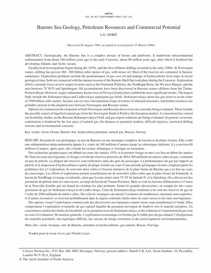
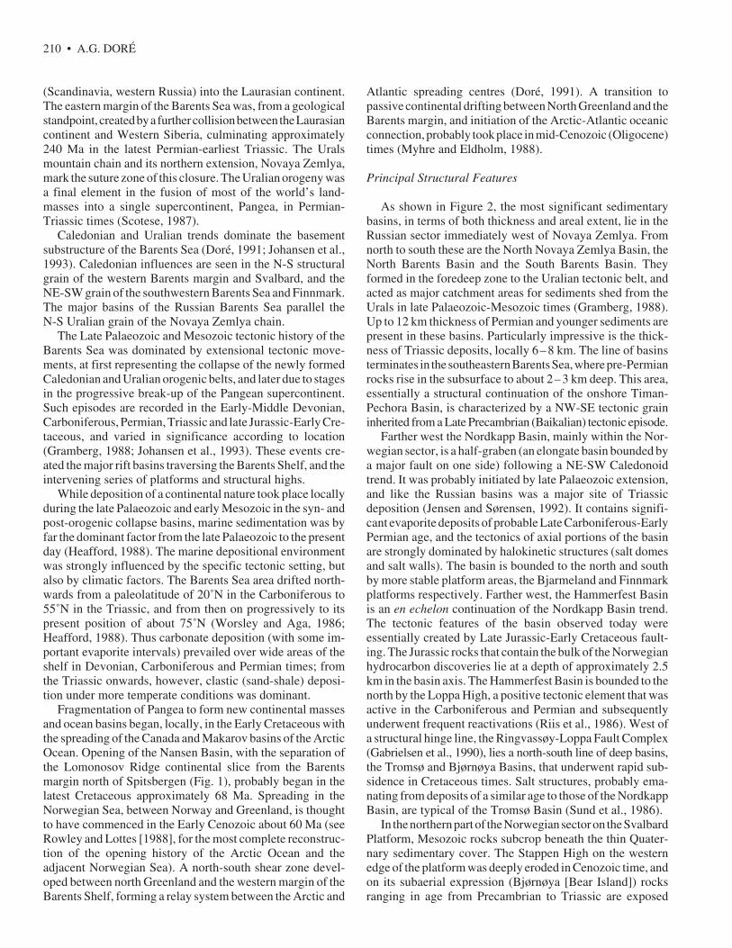
FIG. 2. Location map of the Barents Sea, showing the principal structural features. Sedimentary basins are shaded. BB = Bjørnøya Basin, EB = EdgeøyaBasin, HB = Harstad Basin, HH = Hopen High, SB = Sørvestsnaget Basin, TB = Tiddlybanken Basin, TKF = Trollfjord-Komagelv Fault Zone, TRB = TromsøBasin, VVP = Vestbakken Volcanic Province.
information on the Norwegian and Russian Barents Sea,drawing in addition on the large exploration database(principally well and seismic data) available to the compa-nies active in the area. Observations on the western part ofthe Barents Sea—essentially the Norwegian sector—arebetter constrained than those on the eastern (Russian)portion because of better data availability and quality. Thevastness of the Barents Sea and the concomitant volume ofassociated literature ensure that only the essential issuescan be covered here. The reader is, however, directedtoward sources of additional information on importanttopics.
SUMMARY OF BARENTS SEA GEOLOGY
The Barents Sea consists of a complex mosaic of platformareas and basins (Fig. 2), originally formed by two majorcontinental collisions and subsequently sundered by conti-nental separation. The first collision event, the Caledonianorogeny (mountain-building episode), culminated approxi-mately 400 Ma (million years ago). It represented the closureof the Iapetus Ocean, a major seaway occupying a positionsimilar, but somewhat oblique to, the present northeast Atlan-tic. This collision resulted in the consolidation of the Laurentianplate (Greenland, North America) and the Baltic plate
210 • A.G. DORÉ
(Scandinavia, western Russia) into the Laurasian continent.The eastern margin of the Barents Sea was, from a geologicalstandpoint, created by a further collision between the Laurasiancontinent and Western Siberia, culminating approximately240 Ma in the latest Permian-earliest Triassic. The Uralsmountain chain and its northern extension, Novaya Zemlya,mark the suture zone of this closure. The Uralian orogeny wasa final element in the fusion of most of the world’s land-masses into a single supercontinent, Pangea, in Permian-Triassic times (Scotese, 1987).
Caledonian and Uralian trends dominate the basementsubstructure of the Barents Sea (Doré, 1991; Johansen et al.,1993). Caledonian influences are seen in the N-S structuralgrain of the western Barents margin and Svalbard, and theNE-SW grain of the southwestern Barents Sea and Finnmark.The major basins of the Russian Barents Sea parallel theN-S Uralian grain of the Novaya Zemlya chain.
The Late Palaeozoic and Mesozoic tectonic history of theBarents Sea was dominated by extensional tectonic move-ments, at first representing the collapse of the newly formedCaledonian and Uralian orogenic belts, and later due to stagesin the progressive break-up of the Pangean supercontinent.Such episodes are recorded in the Early-Middle Devonian,Carboniferous, Permian, Triassic and late Jurassic-Early Cre-taceous, and varied in significance according to location(Gramberg, 1988; Johansen et al., 1993). These events cre-ated the major rift basins traversing the Barents Shelf, and theintervening series of platforms and structural highs.
While deposition of a continental nature took place locallyduring the late Palaeozoic and early Mesozoic in the syn- andpost-orogenic collapse basins, marine sedimentation was byfar the dominant factor from the late Palaeozoic to the presentday (Heafford, 1988). The marine depositional environmentwas strongly influenced by the specific tectonic setting, butalso by climatic factors. The Barents Sea area drifted north-wards from a paleolatitude of 20˚N in the Carboniferous to55˚N in the Triassic, and from then on progressively to itspresent position of about 75˚N (Worsley and Aga, 1986;Heafford, 1988). Thus carbonate deposition (with some im-portant evaporite intervals) prevailed over wide areas of theshelf in Devonian, Carboniferous and Permian times; fromthe Triassic onwards, however, clastic (sand-shale) deposi-tion under more temperate conditions was dominant.
Fragmentation of Pangea to form new continental massesand ocean basins began, locally, in the Early Cretaceous withthe spreading of the Canada and Makarov basins of the ArcticOcean. Opening of the Nansen Basin, with the separation ofthe Lomonosov Ridge continental slice from the Barentsmargin north of Spitsbergen (Fig. 1), probably began in thelatest Cretaceous approximately 68 Ma. Spreading in theNorwegian Sea, between Norway and Greenland, is thoughtto have commenced in the Early Cenozoic about 60 Ma (seeRowley and Lottes [1988], for the most complete reconstruc-tion of the opening history of the Arctic Ocean and theadjacent Norwegian Sea). A north-south shear zone devel-oped between north Greenland and the western margin of theBarents Shelf, forming a relay system between the Arctic and
Atlantic spreading centres (Doré, 1991). A transition topassive continental drifting between North Greenland and theBarents margin, and initiation of the Arctic-Atlantic oceanicconnection, probably took place in mid-Cenozoic (Oligocene)times (Myhre and Eldholm, 1988).
Principal Structural Features
As shown in Figure 2, the most significant sedimentarybasins, in terms of both thickness and areal extent, lie in theRussian sector immediately west of Novaya Zemlya. Fromnorth to south these are the North Novaya Zemlya Basin, theNorth Barents Basin and the South Barents Basin. Theyformed in the foredeep zone to the Uralian tectonic belt, andacted as major catchment areas for sediments shed from theUrals in late Palaeozoic-Mesozoic times (Gramberg, 1988).Up to 12 km thickness of Permian and younger sediments arepresent in these basins. Particularly impressive is the thick-ness of Triassic deposits, locally 6–8 km. The line of basinsterminates in the southeastern Barents Sea, where pre-Permianrocks rise in the subsurface to about 2–3 km deep. This area,essentially a structural continuation of the onshore Timan-Pechora Basin, is characterized by a NW-SE tectonic graininherited from a Late Precambrian (Baikalian) tectonic episode.
Farther west the Nordkapp Basin, mainly within the Nor-wegian sector, is a half-graben (an elongate basin bounded bya major fault on one side) following a NE-SW Caledonoidtrend. It was probably initiated by late Palaeozoic extension,and like the Russian basins was a major site of Triassicdeposition (Jensen and Sørensen, 1992). It contains signifi-cant evaporite deposits of probable Late Carboniferous-EarlyPermian age, and the tectonics of axial portions of the basinare strongly dominated by halokinetic structures (salt domesand salt walls). The basin is bounded to the north and southby more stable platform areas, the Bjarmeland and Finnmarkplatforms respectively. Farther west, the Hammerfest Basinis an en echelon continuation of the Nordkapp Basin trend.The tectonic features of the basin observed today wereessentially created by Late Jurassic-Early Cretaceous fault-ing. The Jurassic rocks that contain the bulk of the Norwegianhydrocarbon discoveries lie at a depth of approximately 2.5km in the basin axis. The Hammerfest Basin is bounded to thenorth by the Loppa High, a positive tectonic element that wasactive in the Carboniferous and Permian and subsequentlyunderwent frequent reactivations (Riis et al., 1986). West ofa structural hinge line, the Ringvassøy-Loppa Fault Complex(Gabrielsen et al., 1990), lies a north-south line of deep basins,the Tromsø and Bjørnøya Basins, that underwent rapid sub-sidence in Cretaceous times. Salt structures, probably ema-nating from deposits of a similar age to those of the NordkappBasin, are typical of the Tromsø Basin (Sund et al., 1986).
In the northern part of the Norwegian sector on the SvalbardPlatform, Mesozoic rocks subcrop beneath the thin Quater-nary sedimentary cover. The Stappen High on the westernedge of the platform was deeply eroded in Cenozoic time, andon its subaerial expression (Bjørnøya [Bear Island]) rocksranging in age from Precambrian to Triassic are exposed
BARENTS SEA GEOLOGY AND PETROLEUM RESOURCES • 211
(Worsley and Aga, 1986). The western margin of the BarentsShelf bordering the continent-ocean transition (Fig. 2) ischaracterized by the effects of Cenozoic tectonics and sedi-mentation associated with the northeast Atlantic continentalseparation. Large thicknesses of Cenozoic sediments weredeposited in this area both before and after the onset ofpassive continental drifting in the Oligocene (Johansen et al.,1993). The sediments were derived from uplift and erosion ofthe Barents Shelf immediately to the east. Several kilometersof sediments were probably removed from this area duringthe Cenozoic (Nyland et al., 1992). Erosion and redepositionare thought to have been particularly intense during thePleistocene glaciations.
HISTORY OF BARENTS SEA PETROLEUMEXPLORATION
Norway
If the Svalbard archipelago is regarded as part of theBarents Sea geological regime, then it can be confidentlystated that petroleum exploration began in this area in theearly twentieth century. Early geological surveys of theislands identified oil seeps, and in 1926 the Store NorskeSpitsbergen Kullkompani began to investigate the hydrocar-bon potential of central Spitsbergen. The first explorationwells were drilled by Norsk Polarnavigasjon (1963) and theAmoseas Group (1965–66). To date fourteen wildcat wellshave been completed. These wells reported frequent shows ofoil and gas, but only minor producible gas has so far been found.Petroleum exploration with similarly disappointing resultshas also been carried out by Russian interests, who have theright to explore for minerals on Spitsbergen under the provi-sions of the Svalbard Treaty of 1920 (Fleischer, 1993).
From the evidence to date it must be assumed that potentialexists for more substantial discoveries on Svalbard. Largeareas of central Spitsbergen are still licensed to companies,the most active being the Store Norske/Norsk Hydro group.Exploration will continue to be hindered by widespread icecover, by permafrost conditions, and by the restricted seasonavailable for drilling. A detailed description of petroleumexploration in Spitsbergen is given by Nøttvedt et al. (1993).
As a result of the numerous geological surveys conductedsince the early part of the century, Svalbard served as a usefultemplate for early exploration of the Barents Sea. In particu-lar, the presence of thick sedimentary rocks of Mesozoic-Cenozoic age in the archipelago led early workers to suspectthat a similar succession could lie offshore. Thus Harland(1969:40) reasoned that, compared to Spitsbergen, “the BarentsShelf submarine surface … is not at a lower level because ofgreater erosion. In these circumstances relatively more of thestratigraphic sequence may be preserved there than wouldotherwise be expected. This argument improves whateverpetroleum prospects there may be in the Barents Shelf.”
Such arguments, and the success of exploration drilling inthe North Sea in the mid 1960s, encouraged the Norwegian
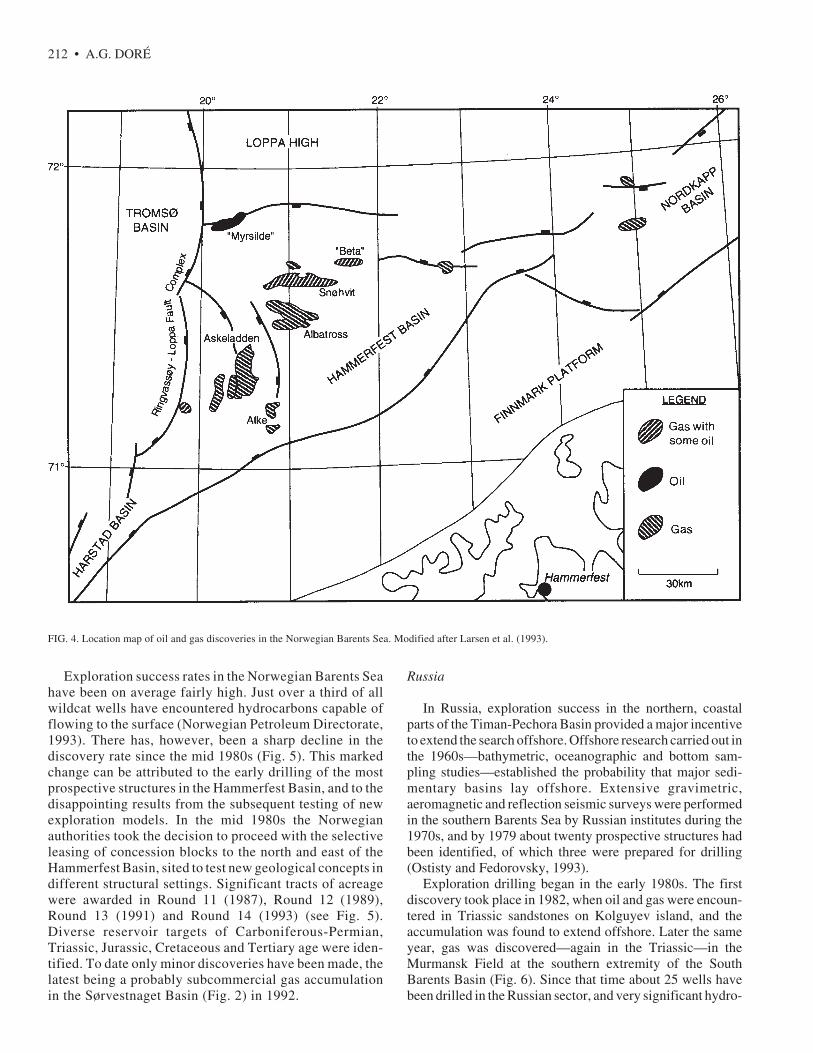
authorities to begin geophysical investigations in the BarentsSea in 1969. Reflection seismic data acquired in the followingfew years confirmed the existence of thick sedimentarysuccessions and delineated the main offshore sedimentarybasins (Rønnevik et al., 1975). In the Norwegian sector, themost promising basins (the Hammerfest and Tromsø Basinsin the southwestern Barents Sea) were targeted because theywere believed to contain reservoir and source rocks similarto those that had proven prospective in North Sea exploration.Acreage was offered in this area and awarded to severalcompanies in the Norwegian 5th Round in 1980. The firstwell (7120/12-1) was drilled the same year, and the firstdiscoveries (the Alke and Askeladden gas fields) were madethe following year (Westre, 1984).
Subsequently, acreage has been leased steadily to thecompanies in a series of concession rounds (Figs. 3 and 5).The largest award in terms of total concession area was madeas part of Round 13 in 1991. The most recent concessionswere allocated under Round 14 in 1993. Drilling activity hasbeen maintained at a fairly low but stable level during thisperiod. To date just over 50 wildcat/appraisal wells have beendrilled, compared with the approximately 600 such wellsdrilled in the Norwegian North Sea (County NatwestWoodmac, 1992; Norwegian Petroleum Directorate, 1993).The most important discoveries were made in the early to mid1980s. These comprise the Askeladden, North Albatross andSnøhvit Fields (Fig. 4), which contain predominantly gas inreservoir rocks of Middle Jurassic age. Various authoritiesplace the currently discovered resources of the NorwegianBarents Sea in the region of 260–300 billion Sm3 (standardcubic metres) of gas. Nearly 100 billion Sm3 are contained inthe largest discovery, the Snøhvit Field. Only minor amountsof oil have been discovered.
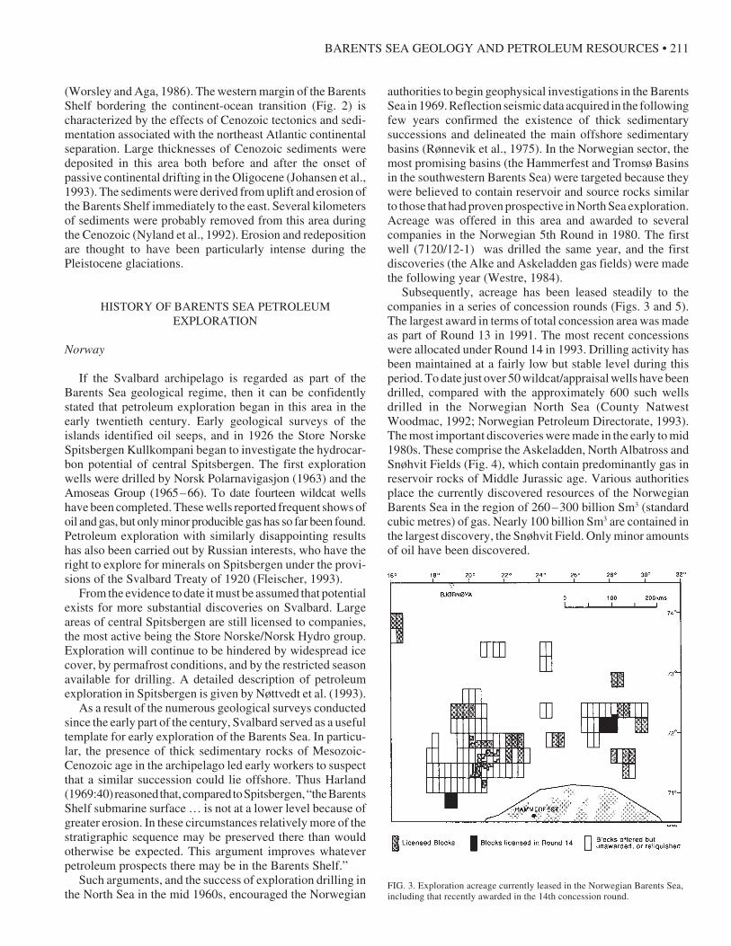
FIG. 3. Exploration acreage currently leased in the Norwegian Barents Sea,including that recently awarded in the 14th concession round.
212 • A.G. DORÉ
FIG. 4. Location map of oil and gas discoveries in the Norwegian Barents Sea. Modified after Larsen et al. (1993).
Exploration success rates in the Norwegian Barents Seahave been on average fairly high. Just over a third of allwildcat wells have encountered hydrocarbons capable offlowing to the surface (Norwegian Petroleum Directorate,1993). There has, however, been a sharp decline in thediscovery rate since the mid 1980s (Fig. 5). This markedchange can be attributed to the early drilling of the mostprospective structures in the Hammerfest Basin, and to thedisappointing results from the subsequent testing of newexploration models. In the mid 1980s the Norwegianauthorities took the decision to proceed with the selectiveleasing of concession blocks to the north and east of theHammerfest Basin, sited to test new geological concepts indifferent structural settings. Significant tracts of acreagewere awarded in Round 11 (1987), Round 12 (1989),Round 13 (1991) and Round 14 (1993) (see Fig. 5).Diverse reservoir targets of Carboniferous-Permian,Triassic, Jurassic, Cretaceous and Tertiary age were iden-tified. To date only minor discoveries have been made, thelatest being a probably subcommercial gas accumulationin the Sørvestnaget Basin (Fig. 2) in 1992.
Russia
In Russia, exploration success in the northern, coastalparts of the Timan-Pechora Basin provided a major incentiveto extend the search offshore. Offshore research carried out inthe 1960s—bathymetric, oceanographic and bottom sam-pling studies—established the probability that major sedi-mentary basins lay offshore. Extensive gravimetric,aeromagnetic and reflection seismic surveys were performedin the southern Barents Sea by Russian institutes during the1970s, and by 1979 about twenty prospective structures hadbeen identified, of which three were prepared for drilling(Ostisty and Fedorovsky, 1993).
Exploration drilling began in the early 1980s. The firstdiscovery took place in 1982, when oil and gas were encoun-tered in Triassic sandstones on Kolguyev island, and theaccumulation was found to extend offshore. Later the sameyear, gas was discovered—again in the Triassic—in theMurmansk Field at the southern extremity of the SouthBarents Basin (Fig. 6). Since that time about 25 wells havebeen drilled in the Russian sector, and very significant hydro-
BARENTS SEA GEOLOGY AND PETROLEUM RESOURCES • 213
FIG. 5. Graphs for the Norwegian Barents Sea showing the progress of licenseawards (top) and the progress of discovery (bottom) to 1991. Redrawn andupdated from County Natwest Woodmac (1992). The units quoted in the lowergraph are millions of barrels of oil equivalent per well. This value is derived bydividing the total resources discovered by the number of exploration wellsdrilled over a given period, and is a measure of exploration success in aprovince. One barrel of oil is volumetrically equivalent to 0.159 Sm3, and is theenergy equivalent of approximately 1000 Sm3 gas.
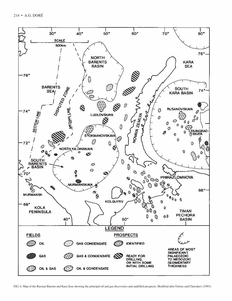
carbon finds have been made. The most spectacular of theseis the Stokmanovskaya Field, discovered in 1988 in thenorthern part of the South Barents Basin. Stokmanovskayacontains gas and condensate in a reservoir consisting ofMiddle-Upper Jurassic marine sandstones. Its gas reservesare currently thought to be about 2500 billion Sm3 (CountyNatwest Woodmac, 1992). To put this figure into perspec-tive, it compares in size to the supergiant Groningen Field ofthe Netherlands, is twice as large as Norway’s largest gasfield (Troll), and contains approximately eight times the totalproven resources of the Norwegian Barents Sea. Other recentdiscoveries include Ludlovskaya, a similar structure toStokmanovskaya and probably comparable in magnitude,and Prirazlomnoya, an oil field with a Carboniferous-Permiancarbonate reservoir situated just offshore from the Timan-Pechora hydrocarbon province (Fig. 6).
On the basis of exploration results to date, the Russian sectorcan be crudely subdivided into two petroleum provinces: asouthern, oil-prone region that is essentially a continuation ofthe onshore Timan-Pechora trend, and a much larger northernregion west of Novaya Zemlya, where gas predominates.
RESERVOIR ROCKS AND HYDROCARBONTRAPPING STYLES
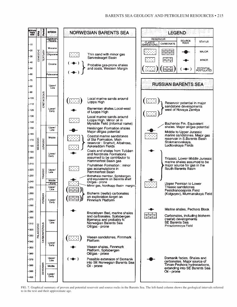
Figure 7 provides a summary by geological age of allreservoirs, proven and postulated, in the Barents Sea. The
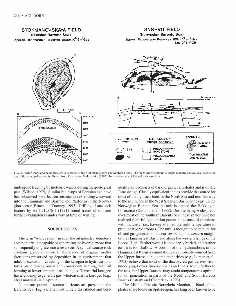
most significant proportion of the hydrocarbon resourcesproven to date in both the Norwegian and Russian BarentsSea is contained within strata of Jurassic age. The majordiscoveries in the Norwegian sector—Snøhvit, Albatross andAskeladden—all have a principal reservoir consisting ofLower-Middle Jurassic sandstone. This unit (the Stø Forma-tion: see Dalland et al., 1988) was deposited in a coastalmarine setting and, where penetrated in the HammerfestBasin, usually has very favourable reservoir properties (highporosity and permeability). Larsen et al. (1993) estimate thatabout 85% of the Norwegian Barents Sea resources lie withinthis formation. Almost all of these resources are natural gas,the thin oil leg of the Snøhvit Field providing a minorexception (Fig. 8). In the giant Russian gas fields,Stokmanovskaya and Ludlovskaya, the principal reservoir issomewhat younger. Most of the resources are in marinesandstones of Upper Jurassic age, with subordinate amountsin the Middle Jurassic (Ostisty and Fedorovsky, 1993). TheStokmanovskaya gas is associated with significant quantitiesof condensate (light hydrocarbon liquids that condense outduring gas production).
The traps that form the Norwegian Jurassic fields aregenerally fault-bounded positive blocks. In contrast, theRussian discoveries made to date appear to be in simplerdome-like structures. This is illustrated in Figure 8, whichcontrasts the principal fields in the two sectors (Snøhvit andStokmanovskaya). In both cases the hydrocarbons are sealedby overlying Upper Jurassic shales.
Triassic and uppermost Permian sandstones contain fairlysignificant resources in the Russian Barents Sea. Discoveriesinclude Murmanskaya (gas), North Kildinskaya (gas), andPestchanoosjorsk on and offshore from the island of Kolguyev(oil and gas) (Fig. 6). The Triassic sediments were depositedin a series of deltas prograding westward from NovayaZemlya, and as a consequence of this depositional environ-ment, reservoir distribution is complex. Alternations of thinsandstones and shales are typical, and sand bodies are fre-quently discontinuous. Reservoir properties are generally notas favourable as those of the Jurassic. This situation alsoapplies in the Norwegian sector, where the Triassic is gener-ally even more sand-poor because of distance from source. Todate, minor Triassic gas accumulations have been found inthe Hammerfest Basin and on the margins of the NordkappBasin (Fig. 4). Triassic traps in both sectors include fault-bounded and domal structures, and sealing is facilitated byintra-Triassic shales.
Palaeozoic rocks comprise the principal reservoirs of theonshore Timan-Pechora Basin. Oil and gas are found insediments ranging in age from Ordovician to Permian. Thisprovince extends offshore into the southeastern RussianBarents Sea, where discoveries such as the Prirazlomnoya oilfield (Fig. 6) have been made in Carboniferous and Permiancarbonates (limestones and dolomites). Trapping is generallywithin bioherm structures (reef-like organic build-ups). Ex-perience from the Timan-Pechora Basin and analogous areasworldwide shows that reservoir properties in such units areenhanced if the bioherm has been exposed subaerially and
214 • A.G. DORÉ
FIG. 6. Map of the Russian Barents and Kara Seas showing the principal oil and gas discoveries and undrilled prospects. Modified after Ostisty and Cheredeev (1993).
BARENTS SEA GEOLOGY AND PETROLEUM RESOURCES • 215
FIG. 7. Graphical summary of proven and potential reservoir and source rocks in the Barents Sea. The left-hand column shows the geological intervals referredto in the text and their approximate age.
216 • A.G. DORÉ
FIG. 8. Sketch maps and geological cross-sections of the Stokmanovskaya and Snøhvit Fields. The maps show contours of depth in metres below sea level to thetop of the principal reservoir. Drawn from Ostisty and Fedorovsky (1993), Johansen et al. (1993) and in-house data.
undergone leaching by meteoric waters during the geologicalpast (Wilson, 1975). Similar build-ups of Permian age havebeen observed on reflection seismic data extending westwardinto the Finnmark and Bjarmeland Platforms in the Norwe-gian sector (Bruce and Toomey, 1993). Drilling of one suchfeature by well 7128/6-1 (1991) found traces of oil, andfurther evaluation is under way at time of writing.
SOURCE ROCKS
The term “source rock,” used in the oil industry, denotes asedimentary unit capable of generating the hydrocarbons thatsubsequently migrate into a reservoir. A typical source rockcontains greater-than-usual abundance of organic matter(kerogen) preserved by deposition in an environment thatinhibits oxidation. Cracking of the kerogen to hydrocarbonstakes place during burial and consequent heating, with oilforming at lower temperatures than gas. Terrestrial kerogenhas a tendency to generate gas, whereas marine kerogen (e.g.,algal material) is oil-prone.
Numerous potential source horizons are present in theBarents Sea (Fig. 7). The most widely distributed and best-
quality unit consists of dark, organic rich shales and is of lateJurassic age. Closely equivalent shales provide the source formost of the hydrocarbons in the North Sea and mid Norwayto the south, and in the West Siberian Basin to the east. In theNorwegian Barents Sea the unit is named the HekkingenFormation (Dalland et al., 1988). Despite being widespreadover most of the southern Barents Sea, these shales have notrealized their full generation potential because of problemswith maturity (i.e., having attained the right temperature toproduce hydrocarbons). The unit is thought to be mature foroil and gas generation in a narrow belt at the western marginof the Hammerfest Basin and along the western fringe of theLoppa High. Farther west it is too deeply buried, and farthereast it is too shallow. A portion of the hydrocarbons in theHammerfest Basin accumulations was probably sourced fromthe Upper Jurassic, but some authorities (e.g., Larsen et al.,1993) believe that most of the discovered gas derives fromunderlying Lower Jurassic shales and coals. Much farther tothe east, the Upper Jurassic may attain temperatures optimalfor oil generation in parts of the North and South BarentsBasins (Ostisty and Cheredeev, 1993).
The Middle Triassic Botneheia Member, a black phos-phatic shale found on Spitsbergen, has long been known to be
BARENTS SEA GEOLOGY AND PETROLEUM RESOURCES • 217
a potential source rock for oil and gas (Bjorøy et al., 1978).Drilling has identified equivalents of this unit in the southernNorwegian Barents Sea, where it is believed to be widespreadbut of very variable quality. The unit is probably mature foroil generation on many of the platform areas and gas-maturein the Hammerfest and Nordkapp Basins. Upper Triassicshales may also locally be of source quality in the Norwegiansector (Johansen et al., 1993). There is evidence that Triassicshales have sourced some of the Norwegian hydrocarbons,but a major contribution has not been proved.
Triassic source rocks are present at several horizons inthe deep Russian basins west of Novaya Zemlya, andcontain a significant proportion of terrestrial organic ma-terial due to proximity to the old Novaya Zemlya land-mass. This factor, and the great burial depths, make theshale predominantly a gas source. The cumulative genera-tion potential from the thick Triassic (and possibly LowerJurassic) sedimentary pile is large, and it is widely as-sumed that the major gas discoveries of the South BarentsBasin emanate from this source.
The significant hydrocarbon resources of the onshoreTiman-Pechora Basin are largely derived from a much oldersource rock, the Domanik unit of Late Devonian to EarlyCarboniferous age (Ulmishek, 1982). The Domanik consistsof dark marine shales and carbonates, and is a high-quality,oil-prone source rock. Sourcing of younger horizons from theDomanik occurred by means of vertical migration throughfaults. The unit extends offshore into the southeastern BarentsSea, where it is believed to have sourced some of the Russianoil and gas accumulations close to shore (Fig. 6). The eco-nomic importance of the Domanik unit has engendered muchspeculation as to whether it extends westward into the Nor-wegian sector. It has been suggested that the Devonian in thisregion, if present, will be developed in a less favourableterrestrial facies (Alsgaard, 1993). However, no Devonianrocks have been drilled and the case for source rocks of thisage remains open.
CURRENT EXPLORATION PROBLEMSAND FUTURE DIRECTIONS
The most significant exploration problem in the BarentsSea, particularly relevant to the Norwegian sector, relatesto the severe uplift and erosion of the area that took placeduring the Cenozoic. Residual oil columns found beneathgas fields in the Hammerfest Basin indicate that the struc-tures were once filled, or partially filled, with oil. Theremoval of up to two kilometers of sedimentary overbur-den from the area comparatively late in geological timehad severe consequences for these accumulations.Exsolution of gas from the oil, and expansion of the gasdue to the decrease in pressure, resulted in expulsion ofmost of the oil from the traps. Seal breaching and spillageprobably also occurred as a result of the uplift. A furtherconsequence of these late movements was the cooling ofthe source rocks in the area, which effectively caused most
hydrocarbon generation to cease. Thus, little new oil wasavailable to fill available trapping space. These mecha-nisms explain the predominance of gas over oil in theBarents Sea (see Nyland et al., 1992, for a fuller descrip-tion of this phenomenon).
Although the problems caused by Cenozoic uplift onlybecame apparent during exploration of the Barents Sea inthe mid 1980s, it is interesting to note that they wereanticipated as early as 1904 by the great Norwegian ex-plorer Fridtjof Nansen. Nansen (1904) postulated lateuplift of the Barents Sea based on bathymetric observa-tions taken during the Norwegian North Polar expeditions(1893 – 96). The relationship of Nansen’s work to currentBarents Sea thinking is discussed in more detail inGabrielsen and Doré (in press), and an excellent descrip-tion of his total contribution to arctic geology can be foundin Hestmark (1991).
The apparent gas-prone nature of the Barents Sea is theprimary reason for the slow pace of exploration in the area.Petroleum companies are essentially searching for oil,which is the economically more attractive phase. Recentexploration efforts have been directed toward locatingtraps in areas that may have been protected from severeuplift, or toward identifying traps that may have receivedremigrated oil evacuated from pre-existing accumulations.
Future Targets
Despite the difficulties outlined above, exploration of theBarents Sea is at an immature stage compared to that of otherpetroleum provinces worldwide, and very significant poten-tial still exists. Exploration has been focused on only a fewbasins, and many of the structural units (Fig. 2) are undrilledor only sparsely drilled. Likewise, exploration has beendirected toward particular stratigraphic successions, whileothers are almost unevaluated. Some of the more promisingof these units are listed in the graphical summary of Figure 7.
The Norwegian Petroleum Directorate (1993) estimatesthat about 930 billion Sm3 gas and 220 million Sm3 oil, orapproximately four times the currently discovered resources,remain to be discovered in the part of the Barents Sea claimedby Norway. This estimate is, of course, associated with a widespread of uncertainty. Because many of the obvious Jurassicpotential traps have been drilled, much of this potential lies atother stratigraphic levels. Some indication as to the nature ofthese targets is given by recent drilling on currently leasedacreage.
In the western part of the area, the Tertiary potential of theWestern Margin has to date only been tested by a single well,which found gas in sands of Oligocene age. Although thereserves proven were small, this result at least demonstratedthat hydrocarbons have been generated and trapped in thearea. Potential may also exist in rocks of Cretaceous age,particularly around the flanks of the Loppa High, which waseroded and shed sands into surrounding basins in Cretaceoustimes. A small oil discovery in Lower Cretaceous marinesands, informally named the Myrsilde Field (Fig. 4), has been
218 • A.G. DORÉ
made on the southern flank of the Loppa High, and analogoustraps probably exist.
In the eastern Norwegian Barents Sea, residual oil hasbeen found by initial drilling in Permian carbonates on theFinnmark Platform (see section on Reservoir Rocks andHydrocarbon Trapping Styles) and further exploration drill-ing could take place on the Round 13 acreage in this area inthe next few years. Targets include other potential traps andstratigraphic levels within the Permian, and sandstones ofLower Carboniferous (Visean) age (Fig. 7). Similar playsprobably exist on the Bjarmeland Platform, but greater depthof burial makes them less immediately attractive.
Six new Barents Sea concessions were awarded to twopartnerships under the Norwegian 14th Round (Fig. 3). Twoof the blocks are located in the Harstad Basin at the south-western extremity of the Barents Sea (Fig. 2), along a possiblecontinuation of the Hammerfest Basin Jurassic trend. Theremaining four blocks center on the southwestern lobe of theNordkapp Basin. Only three wells have been drilled to date onthe flanks of the basin, and the axial parts are undrilled. Sandsand possible source rocks within the thickly developed Triassicsuccession provide the primary exploration incentive in thisarea. A variety of potential trapping styles has been identi-fied, associated in particular with the major salt structures(domes and walls) that dominate the basin (see for exampleLarsen et al., 1993).
A group of six companies is now pooling resources toassess the remaining potential in the Norwegian Barents Seaand to determine future exploration directions. This strategicalliance is a logical response to high exploration costs andunproven commercial potential, but it is an unprecedentedstep in Norway, where the formation of partnerships prior tolicensing has previously been discouraged by the authorities.
In the near future, exploration interest will turn to theunleased area north of 74˚30' N. Preliminary surveys (reflec-tion seismic and sea-bottom sampling) show that basal Jurassic,Triassic and older rocks outcrop on the seabed or lie beneatha thin Quaternary cover over most of this region. Explorationwill therefore center on older reservoir targets, and sourcerocks of Permian, Carboniferous and (possibly) Devonianage must be envisaged for the hydrocarbon source. Seismicdata were made available to the industry by the NorwegianPetroleum Directorate in 1992, and environmental impactstudies on the area are expected to be completed in 1995.These timings suggest that concessions will be availableunder the 16th Norwegian licensing round, probably in 1997.Exploration of this area will be highly seasonal because ofwinter pack-ice. Although the yearly extent of the ice isvariable, it generally reaches south to about 75˚N, with amaximum development in March. This will be a severelogistical constraint, and significant exploration incentiveswill therefore be required to justify the high cost of drillingthe area.
To my knowledge, there are no published quantitativeestimates of undiscovered resources in the Russian BarentsSea. However, the results of the limited drilling to dateindicate that vast potential exists, particularly for the discov-
ery of natural gas (Ostisty and Cheredeev, 1993). As shownin Figure 6, numerous untested structures have been identi-fied, and many of these are classed as “ready for drilling.”
The prospects identified in and on the flanks of the Northand South Barents basins include Jurassic traps of theStokmanovskaya type and some Triassic prospects. Consid-erable potential is also identified in the Lower Cretaceous,which forms the reservoir for the giant Rusanovskaya Field inthe Kara Sea (Fig. 6) and which contains thick sand successionswest of Novaya Zemlya. All of these units are likely tocontain primarily gas and gas condensate generated from thedeep basins.
Prospects in the southeast of the area lie along the trendfrom the Timan-Pechora Basin and the Prirazlomnoya Field(Fig. 6). Reservoir targets will be of Palaeozoic and Triassicage, and, by analogy with local discoveries, potential existsfor both oil and gas.
POLITICAL CONSIDERATIONS
A long-standing dispute exists between the Norwegianand Russian governments as to the position of the boundarydelimiting the economic exploitation rights of the two coun-tries. The Norwegian boundary claim is founded on theGeneva Convention of 1958, which supports the Median Lineconcept—the principle of equidistance from sovereign coastalbaselines. The Russian claim is based on a Soviet decree of1926, which recognizes the Sector Line principle, i.e., that theboundary should follow a line extending northwards from theonshore border to the North Pole. The disputed or “grey” zonebetween these competing claims constitutes a vast portion ofcontinental shelf: 175 000 km2 or approximately one-seventhof the total area of the Barents Sea (Figs. 2 and 6). Thehydrocarbon potential of the disputed zone is poorly under-stood, but is widely assumed to be significant because of itsarea and its proximity to known hydrocarbons in Russianwaters. The Russian authorities have identified several largeprospects within the zone (Fig. 6) and have drilled wells closeto the median line. No acreage has yet been awarded inNorwegian waters close to the disputed area. A full descriptionof international marine law and its application to the BarentsSea can be found in Fleischer (1993).
COMMERCIAL FACTORS
The cost of exploration in the Norwegian sector of theBarents Sea is considerably higher than for other parts of theNorwegian Shelf. This can be attributed to the following factors:
• The remoteness of the area. Although potential shorebasefacilities exist on the mainland at Harstad, Tromsø andHammerfest, these do not yet possess the sophisticatedlogistical support capabilities of the equivalent North Seabases. Special efforts are therefore required by the com-panies to maintain a drilling operation in the area.
BARENTS SEA GEOLOGY AND PETROLEUM RESOURCES • 219
• Climatic conditions. The harsh Arctic climate requires theuse of expensive, specially adapted “fourth generation”drilling rigs. Year-round drilling may also be precludedby climate.
• The necessity for environmental precautions. As is amplyillustrated elsewhere in this volume, the Barents Seacontains important fishing and fish spawning grounds,and is also regarded as one of the last major sanctuaries forwildlife such as sea birds and marine mammals. Environ-mentally sensitive sites abound on adjacent coasts.Concern over such factors has led to the adoption ofexhaustive oil-spill contingency measures for recent drill-ing. For example, the recent 7128/6-1 Round 13 well,drilled by Conoco 55 km from the Finnmark coast, re-quired two standby boats and two oil-spill recovery ves-sels to be on 24-hour call. In addition, drilling seasonsmay be restricted to avoid fish-spawning periods. Thus, inrecent drilling of Thirteenth Round acreage in theSorvestnaget Basin (well 7316/5-1), a restriction wasimposed whereby potential hydrocarbon-bearing levelscould not be penetrated during the most sensitive periodfor fish eggs and larvae, July 1 to August 1.
The commercial development of hydrocarbon resourcesdiscovered in the area will also be subject to these factors, butmust overcome further obstacles. Water depths in the princi-pal Norwegian discovery area, the Hammerfest Basin, are inthe order of 300 m—deeper than those of average North Seafields. Although such depths by no means preclude commer-cial development, they call for less conventional develop-ment schemes such as full subsea development, floatingproduction systems or tension-leg platforms. North Sea fieldscan make cost savings by tie-in to existing production infra-structure, whereas the first Barents Sea developments wouldessentially require stand-alone economics. Finally, and mostimportantly, economics are hampered by distance to poten-tial markets. Although significant gas reserves have beendiscovered, these resources could only reach the main Euro-pean markets through a major commitment to pipelinebuilding, or by transport as liquefied natural gas (LNG). Theseexpensive solutions make Barents Sea gas uncompetitive inthe European market, which is currently amply supplied bygas from sources closer to home such as the North Sea. Oil ismore easily transported via offshore loading and tanker, butthe minor quantities so far discovered do not justify develop-ment. Conceptual economics suggest that an oil field in theNorwegian Barents Sea would require recoverable reservesof about 50 million Sm3 (300 million barrels) to break eveneconomically (e.g., County Natwest Woodmac, 1992).
The Snøhvit gas field, with its significant gas reserves andhigh-performance Jurassic reservoir, will be the first devel-opment in the Norwegian sector, barring more attractivediscoveries in the near future. Development options recentlyevaluated by the operator, Statoil, are full subsea develop-ment with transport to shore via multiphase pipeline, and theuse of a floating production system with gas and condensatepipelines to shore. The most likely option for transport and
sale of the gas would be through liquefaction onshore anddelivery to European markets by LNG tanker. A further, lesslikely option is to use the gas to drive a power station forsupplying electricity to Finland. The latter scheme would not,however, utilize sufficient gas to satisfy the economic hurdlerate for field development. County Natwest Woodmac (1992)estimate that a gas price of $5.20 per thousand cubic feet(1992 dollars) would be required for Snøhvit to break eveneconomically using the LNG option, compared to $2.50 for agas field in the Norwegian North Sea. These factors suggestthat, given current market projections, production of Snøhvitgas is unlikely before the turn of the century.
Reserves discovered in the Russian Barents Sea dwarfthose of Norwegian waters. Gas fields such asStokmanovskaya and Ludlovskaya contain resources compa-rable to those of the Western Siberian gas fields and, given theright conditions, would be capable of guaranteeing suppliesto markets for half a century or more. Nevertheless, theysuffer from the same economic constraints as their Norwe-gian counterparts—distance to market, harsh climatic condi-tions and environmental concerns. Development concepts forthe Stokmanovskaya supergiant have recently been evalu-ated by a consortium of Russian, American, Norwegian andFinnish companies. Stokmanovskaya gas would most prob-ably be transported by pipeline to feed the central Europeanmarket. Once again, however, production is not expectedbefore the turn of the century. Oil discoveries such asPrirazlomnoya, just offshore from the productive Timan-Pechora Basin, would also be logical candidates for exploita-tion in the relatively near future, but at time of writing no firmdevelopment plans are known to the author.
CONCLUSIONS
The Barents Shelf houses substantial reserves of naturalgas. World-class gas fields have been proven in both theNorwegian and Russian sectors, with the Russian discoveriesbeing particularly impressive. Despite some disappointments,the Barents Sea is only sparsely explored, and the overallexpectation for hydrocarbon discoveries remains high.
The potential for discovery and possible development ofpetroleum reserves must, however, be seen against the back-ground of the area’s important marine resources and knownenvironmental sensitivity. Public concern over conservationissues is shared by most oil company workers who, naturally,have no wish to see some recent, disastrous arctic oil spillsrepeated in the Barents Sea. During the 14th concession round(1993), a number of environmental pressure groups lobbiedthe Norwegian oil companies, urging them not to apply forBarents Sea acreage. They argued that the Barents Sea, as oneof the few remaining areas of natural wilderness on the globe,should be left untouched by further industrial development.
In the short term it seems that this wish will be fulfilled, foreconomic rather than environmental reasons. As shown inearlier sections, the pace of exploration in the Barents Sea iscomparatively slow, and commercial development of reserves
220 • A.G. DORÉ
is unlikely before the next century. In the longer term,however, this situation will change. At current rates of con-sumption, world oil reserves are expected to decline sharplyby the middle of the 21st century (Campbell, 1991; Lerche1992). Natural gas is more widespread and plentiful, butincreased demand for this source of energy will soon depletesupplies close to the principal markets. Barring unforeseengeopolitical upheavals, attention will inevitably turn to logis-tically difficult areas such as the Barents Sea to meet globalenergy needs. Local political factors—for example, the desire tobring industrial development and livelihoods to remote areassuch as northern Norway—could accelerate this process.
Thus, it is reasonable to speculate that by the year 2050 theBarents Sea will have developed into a major centre forcommercial hydrocarbon exploration. Fifty years is a longtime in terms of human foresight, but a short time in the lifeof a major marine ecosystem. Barents Sea explorers in thenot-too-distant future will face many of the problems encoun-tered today, and will have some tough decisions to make.
ACKNOWLEDGEMENTS
I am grateful to Aston Embry, Brian Harland and an anonymousreviewer for their helpful comments on the manuscript, and toKaren McCullough for good editorial handling. I also thank KnutPedersen’s drafting department at Conoco Norway Inc. for producingthe text figures, and Mike Beling of Statoil U.K. Ltd. for additionalgraphics work. The opinions in this paper are my own and do notnecessarily represent those of either of the companies I have workedfor during its preparation.
REFERENCES
ALSGAARD, P.C. 1993. Eastern Barents Sea Late Paleozoicsetting and potential source rocks. In: Vorren, T.O., Bergsager,E., Dahl-Stamnes, Ø.A., Holter, E., Johansen, B., Lie, E., andLund, T., eds. Arctic geology and petroleum potential. NorwegianPetroleum Society (NPF) Special Publication 2. Amsterdam:Elsevier. 408 –418.
BJORØY, M., VIGRAN, J.O., and RØNNINGSLAND, T.M. 1978.Source rock evaluation of Mesozoic shales from Svalbard. IKU(Continental Shelf Institute) Open Report 160/1/78. 214 p.
BRUCE, J.R., and TOOMEY, D.F. 1993. Late Palaeozoic biohermoccurrences of the Finnmark Shelf, Norwegian Barents Sea:Analogues and regional significance. In: Vorren, T.O., Bergsager,E., Dahl-Stamnes, Ø.A., Holter, E., Johansen, B., Lie, E., andLund, T., eds. Arctic geology and petroleum potential. NorwegianPetroleum Society (NPF) Special Publication 2. Amsterdam:Elsevier. 377 –392.
CAMPBELL, C.J. 1991. Golden century of oil, 1950-2050: Thedepletion of a resource. Dordrecht, Boston, London: ClairAcademic Publishers. 345 p.
COUNTY NATWEST WOODMAC. 1992. Barents Sea Update.County Natwest Woodmac, Northwest Europe Report. Oil andGas 76:4 –14.
DALLAND, A., WORSLEY, D., and OFSTAD, K. 1988. Alithostratigraphic scheme for the Mesozoic and Cenozoicsuccession offshore mid- and northern Norway. NorwegianPetroleum Directorate Bulletin 4. 65 p.
DORÉ, A.G. 1991. The structural foundation and evolution ofMesozoic seaways between Europe and the Arctic. Palaeo-geography, Palaeoclimatology, Palaeoecology 87:441–492.
FLEISCHER, C.A. 1993. International law and its application tothe Arctic. In: Vorren, T.O., Bergsager, E., Dahl-Stamnes, Ø.A.,Holter, E., Johansen, B., Lie, E., and Lund, T., eds. Arcticgeology and petroleum potential. Norwegian Petroleum Society(NPF) Special Publication 2. Amsterdam: Elsevier. 721 –731.
GABRIELSEN, R.H., and DORÉ, A.G. In press. The history oftectonic models on the Norwegian continental shelf. In: Hanslien,S. et al., eds. Petroleum exploration and exploitation in Norway—Past experiences and future challenges: A celebration of 25years. Norwegian Petroleum Society (NPF) Special Publication5. Amsterdam: Elsevier.
GABRIELSEN, R.H., FÆRSETH, R.B., JENSEN, L.N.,KALHEIM, J.E., and RIIS, F. 1990. Structural elements of theNorwegian continental shelf. Part 1: The Barents Sea Region.Norwegian Petroleum Directorate Bulletin 6. 33 p.
GRAMBERG, I.S., ed. 1988. The Barents Shelf Platform. PGOSevmorgeologia. Leningrad: Nedra. 263 p.
HARLAND, W.B. 1969. Mantle changes beneath the BarentsShelf. Transactions of the New York Academy of Sciences,Series II. 31(1):25 –41.
HEAFFORD, A.P. 1988. Carboniferous through Triassicstratigraphy of the Barents Shelf. In: Harland, W.B., andDowdswell, E.K., eds. Geological evolution of the Barents Shelfregion. London: Graham and Trotman. 89 –108.
HESTMARK, G. 1991. Fridtjof Nansen and the geology of theArctic. Earth Sciences History 10(2):168 –212.
JENSEN, L.N., and SØRENSEN, K. 1992. Tectonic frameworkand halokinesis of the Nordkapp Basin, Barents Sea. In: Larsen,R.M., Brekke, H., Larsen, B.T., and Talleraas, E., eds. Structuraland tectonic modelling and its application to petroleum geology.Norwegian Petroleum Society (NPF) Special Publication 1.Amsterdam: Elsevier. 109 –120.
JOHANSEN, S.E., OSTISTY, B.K., BIRKELAND, Ø.,FEDOROVSKY, Y.F., MARTIROSJAN, V.N., BRUUNCRISTENSEN, O., CHEREDEEV, S.I., IGNATENKO, E.A.,and MARGULIS, L.S. 1993. Hydrocarbon potential in theBarents Sea region: Play distribution and potential. In: Vorren,T.O., Bergsager, E., Dahl-Stamnes, Ø.A., Holter, E., Johansen,B., Lie, E., and Lund, T., eds. Arctic geology and petroleumpotential. Norwegian Petroleum Society (NPF) SpecialPublication 2. Amsterdam: Elsevier. 273 –320.
LARSEN, R.M., FJÆRAN, T., and SKARPNES, O. 1993.Hydrocarbon potential of the Norwegian Barents Sea based onrecent well results. In: Vorren, T.O., Bergsager, E., Dahl-Stamnes, Ø.A., Holter, E., Johansen, B., Lie, E., and Lund, T.,eds. Arctic geology and petroleum potential. NorwegianPetroleum Society (NPF) Special Publication 2. Amsterdam:Elsevier. 321 –331.
LERCHE, I. 1992. Oil exploration: Basin analysis and economics.San Diego: Academic Press Inc. and HBJ. 178 p.
BARENTS SEA GEOLOGY AND PETROLEUM RESOURCES • 221
MYHRE, A., and ELDHOLM, O. 1988. The western Svalbardmargin (74-80˚N). Marine and Petroleum Geology 5:134 –156.
NANSEN, F. 1904. The bathymetrical features of the north polarseas, with a discussion of the continental shelves and previousoscillations of the shore-line. In: Nansen, F., ed. The NorwegianNorth Polar expedition 1893 –1896. Scientific results IV(13).Christiania: Jacob Dybwad. 232 p.
NORWEGIAN PETROLEUM DIRECTORATE. 1993. Petroleumresources—Norwegian continental shelf. Stavanger: NorwegianPetroleum Directorate. 38 p.
NØTTVEDT, A., LIVBJERG, F., MIDBØE, P.F., andRASMUSSEN, E. 1993. Hydrocarbon potential of the CentralSpitsbergen Basin. In: Vorren, T.O., Bergsager, E., Dahl-Stamnes, Ø.A., Holter, E., Johansen, B., Lie, E., and Lund, T.,eds. Arctic Geology and Petroleum Potential. NorwegianPetroleum Society (NPF) Special Publication 2. Amsterdam:Elsevier. 333 –361.
NYLAND, B., JENSEN, L.N., SKAGEN, J., SKARPNES, O., andVORREN, T.O. 1992. Tertiary uplift and erosion in the BarentsSea: Magnitude, timing and consequences. In: Larsen, R.M.,Brekke, H., Larsen, B.T., and Talleraas, E., eds. Structural andtectonic modelling and its application to petroleum geology.Norwegian Petroleum Society (NPF) Special Publication 1.Amsterdam: Elsevier. 153 –162.
OSTISTY, B.K., and CHEREDEEV, S.I. 1993. Main factorscontrolling regional oil and gas potential in the West Arctic,former USSR. In: Doré, A.G. et al., eds. Basin modelling:Advances and applications. Norwegian Petroleum Society (NPF)Special Publication 3. Amsterdam: Elsevier. 591 –597.
OSTISTY, B.K., and FEDOROVSKY, Y.F. 1993. Main results ofoil and gas prospecting in the Barents and Kara Seas inspireoptimism. In: Vorren, T.O., Bergsager, E., Dahl-Stamnes, Ø.A.,Holter, E., Johansen, B., Lie, E., and Lund, T., eds. Arctic
geology and petroleum potential. Norwegian Petroleum Society(NPF) Special Publication 2. Amsterdam: Elsevier. 243 –252.
RIIS, F., VOLLSET, J., and SAND, M. 1986. Tectonic developmentof the western margin of the Barents Sea and adjacent areas.American Association of Petroleum Geologists Memoir 40.661 –676.
RØNNEVIK, H.D., BERGSAGER, E., MOE, A., ØVREBØ, O.,NAVRESTAD, T., and STANGENES, J. 1975. The geology ofthe Norwegian continental shelf. In: Woodland, A.W., ed.Petroleum and the continental shelf of northwest Europe. Volume1, Geology. London: Institute of Petroleum. 117 –129.
ROWLEY, D.B., and LOTTES, A.K. 1988. Plate-kinematicreconstructions of the North Atlantic and Arctic: Late Jurassic topresent. Tectonophysics 155:73 –120.
SCOTESE, C.R., Coordinator. 1987. Phanerozoic plate tectonicreconstructions. Paleoceanographic mapping project, Instituteof Geophysics, University of Texas Technical Report 90. Mapportfolio.
SUND, T., SKARPNES, O., JENSEN, L.N., and LARSEN, R.M.1986. Tectonic development and hydrocarbon potential offshoreTroms, northern Norway. American Association of PetroleumGeologists Memoir 40. 615 – 627.
ULMISHEK, G. 1982. Petroleum geology and resource assessmentof the Timan-Pechora Basin, USSR, and the adjacent Barents-Northern Kara Shelf. Argonne National Laboratory, ReportEES-TM-199. 197 p.
WESTRE, S. 1984. The Askeladd gas field—Troms 1. In: Spencer,A.M. et al., eds. Petroleum geology of the north Europeanmargin. London: Graham and Trotman. 33 –39.
WILSON, J.L. 1975. Carbonate facies in geologic history. Berlin:Springer-Verlag. 471 p.
WORSLEY, D., and AGA, O.J., eds. 1986. The geological historyof Svalbard. Stavanger: Statoil. 121 p.