Embed Size (px)
Citation preview

APACHE ENERGY LTD (ABN 39 009 301 964) 100 ST GEORGES TERRACE / PERTH / WA / 6000 TEL (08) 6218 7100 / FAX (08) 6218 7200
Balnaves Deep-2 & 3 Environment Plan
Summary

Balnaves Deep-2 & 3 Environment Plan 2 of 19
CONTENTS
1. INTRODUCTION .................................................................................................................................... 3
2. LOCATION OF THE ACTIVITY ................................................................................................................. 4
3. DESCRIPTION OF THE RECEIVING ENVIRONMENT ................................................................................ 6
3.1 Physical Environment ......................................................................................................................... 6
3.2 Biological Environment ...................................................................................................................... 6
3.3 Socio-economic environment ............................................................................................................. 6
4. DESCRIPTION OF THE ACTION .............................................................................................................. 8
5. MAJOR ENVIRONMENTAL HAZARD AND CONTROLS ............................................................................ 9
6. MANAGEMENT APPROACH .................................................................................................................10
7. CONSULTATION ...................................................................................................................................11
8. CONTACT DETAILS ...............................................................................................................................12
9. ENVIRONMENTAL ASPECTS, IMPACTS AND CONTROLS .......................................................................13
10. REFERENCES ......................................................................................................................................19

Balnaves Deep-2 & 3 Environment Plan 3 of 19
1. INTRODUCTION
Apache Energy Ltd (Apache) proposes to drill the appraisal well Balnaves Deep-2 and sidetrack to Balnaves Deep-3 (referred to jointly as Balnaves Deep-2 & 3) in permit area WA-49-L in Commonwealth Waters. Balnaves Deep-2 will be drilled first and Balnaves Deep-3 will only be drilled if the 216 mm (8½”) for Balnaves Deep-2 does not require the contingent liner. If the well is considered to be commercially viable, the wellbore will be suspended for future sidetrack opportunities.
The Balnaves Deep-2 & 3 Environment Plan (EP) has been prepared in accordance with the Offshore Petroleum and Greenhouse Gas Storage (Environment) Regulations 2009 (OPGGS(E) Regulations). The EP has been reviewed and accepted by the National Offshore Petroleum Safety and Environmental Management Authority (NOPSEMA).
This EP summary has been prepared as per the requirements of Regulation 11 (7) and (8) of the referenced OPGGS(E) Regulations.
Balnaves Deep-2 & 3 Environment Plan 4 of 19
2. LOCATION OF THE ACTIVITY
The Balnaves Deep-2 & 3 well location is in Commonwealth waters in Exploration Permit Area WA-49-L (Figure 1) in approximately 148 m of water depth. The surface hole location coordinates are given in Error! Reference source not found. below and is approximately 41 km from the nearest Marine Conservation Reserve (Montebello/Barrow Island) and greater than 48 km from the nearest coastline (
Table 2).
Table 1: Surface location for Balnaves Deep-2 & 3
Parameter Balnaves Deep-2 & 3
Surface hole location
(GDA 94 Zone 50)
20˚ 01’ 50.02”N (Lat) 115˚ 12’ 6.153”E (Long)
311901.910 (Easting) and 7784126 (Northing)
Table 2: Distances from Surface hole location to key regional features
Regional Feature Distance from Balnaves Deep-2 & 3
Closest boundary to Montebello/Barrow Island Marine Conservation Reserve
41 km
Closest Island in the Montebello Island group 49 km
Varanus Island 77 km
Barrow Island 75 km
Distance to Ningaloo World Heritage Area 191 km
Balnaves Deep-2 & 3 Environment Plan 5 of 19
Figure 1: Location Map for Balnaves Deep-2 & 3

Balnaves Deep-2 & 3 Environment Plan 6 of 19
3. DESCRIPTION OF THE RECEIVING ENVIRONMENT
3.1 Physical Environment
The Balnaves Deep-2 & 3 appraisal well is located within the North-West Marine Bioregion in the NWS province in approximately 147 m water depth. Wind patterns in the area are monsoonal with a marked seasonal pattern and extreme wind conditions may be generated in the area by tropical cyclones during the summer months (November to April). The dominant offshore current in the Exmouth sub-basin is the Leeuwin Current which carries warm tropical water south along the Western Australia (WA) continental shelf. The Indonesian throughflow is also important in the area influencing the upper 200 m of the outer NWS. This current brings warm and relatively fresh water to the region from the western Pacific via the Indonesian archipelago (Woodside, 2005). The site of the Balnaves Deep-2 & 3 location experiences significant drift currents that can be relatively fast (1 to 2 knots) and complex, represented as a series of interconnected eddies and connecting flows (APASA, 2011).
3.2 Biological Environment
Four site surveys have been conducted in the Balnaves Deep-2 & 3 area in 2007 – 2010 (Neptune Geomatics, 2012) and indicate that no significant topographic features were found within the 4 km by 4 km grid and the seabed is of low relief unconsolidated calcareous material split into three categories: sandy clayey silt, sandy silt and fine to coarse sand. This habitat supports a diverse benthic infauna consisting of predominantly mobile burrowing species such as molluscs, crustaceans, polychaetes, sipunclid and platyhelminth worms, asteroids, echinoids and other small animals. Water depths at the site mean that benthic habitats including seagrass, algae and scleractinian corals are not present. The EPBC Act Protected Matters Search Database lists nine species of marine fauna, found within one kilometre of the survey area, listed as threatened species (endangered or vulnerable) under the EPBC Act. In addition, these species are also listed as migratory along with 6 other marine species (DSEWPaC, 2012). The timing of the Balnaves Deep-2&3 drilling activity coincides with the humpback whale northern migration and possibly the whale shark migration away from Ningaloo reef, but the well site lies within a broad migratory pathway and is not expected to deter them from their migratory path. The area has no other known feeding, resting, breeding and/or nesting areas or constricted migratory pathways. The abundance of these species is expected to be low and the presence of the drill rig may result in localised behavioural avoidance but this is not considered significant and will not impact the population of these species.
3.3 Socio-economic environment
The Balnaves Deep-2&3 well is located within or adjacent to four Commonwealth fisheries which are permitted to operate within the proposed Balnaves Deep-2 & 3 drilling location. Effective fishing effort is either non-existent or of very limited nature (AFMA, 2010). The North West Slope Trawl Fishery is the only Commonwealth licensed fishery with historical effort operating in the vicinity of the Balnaves Deep-2 & 3 drilling location. In addition seven State managed fisheries have boundaries that overlie or are in close proximity to the location. Majority of fisheries effort on the NWS is typically focussed on areas of water depths of 100m and less.
There are no known or recognised shipping routes through the proposed Balnaves Deep-2 & 3 drilling location. There is a shipping route heading northeast to the west of the proposed drilling location however, a relatively low number of vessels use this (AEL, 2010; Woodside 2006).
Balnaves Deep-2 & 3 Environment Plan 7 of 19
Given the location of the Balnaves Deep-2&3 well in deep offshore waters, it is not accessed for tourism activities (recreational fishing, diving, swimming and boating) as the large majority of these activities occur within 2 nm of the shoreline including the Ningaloo Reef and Cape Range National Park.
The proposed Balnaves Deep-2 & 3 well location and surrounding waters are also used for petroleum exploration and development. The nearest production activity is the Pluto Production Platform and subsea pipeline located in Exploration Permit WA-356-P.
There are no listed Commonwealth Heritage Places or National Heritage Places within, or in the immediate vicinity of the proposed Balnaves Deep-2 & 3 drilling location. Marine Parks and Reserves of Conservation Significance are within the region with the closest marine park (Montebello/Barrow Island Marine Conservation Reserve) located 49 km to the southeast.

Balnaves Deep-2 & 3 Environment Plan 8 of 19
4. DESCRIPTION OF THE ACTIVITY
The Balnaves Deep-2&3 appraisal well will be drilled using the Atwood Falcon semi-submersible drilling rig, operated by Atwood Oceanics and supported by two main vessels DOF Subsea Skandi Atlantic and UOS Endeavour. Personnel will be transferred to and from the rig by helicopter from Barrow Island and Karratha. The operations will commence in June 2012 over a period of approximately 60 days with completion expected mid to late September.
Each hole will be drilled to target depth and evaluated using wire-line logging (and vertical seismic profiling (VSP) on Balnaves Deep-2 only) before plugging and abandoning each well. Balnaves Deep-3 will only be drilled once the Balnaves Deep-2 is plugged/abandoned and only if a contingent liner is not required for Balnaves Deep-2. Water based Muds (WBM) and Synthetic Based Muds (SBM) will be utilised and no well testing will be undertaken.
If the well is considered to be commercially viable, it will be sealed using mechanical and cement plugs commensurate with Apache’s suspension and abandonment procedures and secured and suspended for future utility. Should the well prove to be commercially unviable, it will be abandoned and cement plugs will be set at various depths in the well bore to seal the well, the casing will be cut off below the surface of the seabed and all seabed obstructions will be removed. A remotely operated vehicle will then be used to survey the seabed to ensure that no debris remains from the operations.

Balnaves Deep-2 & 3 Environment Plan 9 of 19
5. MAJOR ENVIRONMENTAL HAZARD AND CONTROLS
AEL undertook an environmental risk assessment for routine and non-routine events for Balnaves Deep-2&3 drilling centred around a hazard identification workshop attended by a subset of Apache’s environmental scientists and drilling personnel, held on 22 March 2012. The outcomes of a broader scale hazard identification workshop on Apache’s drilling activities across the NWS (Oracle, 2011), independently facilitated by risk consultants using the combined experience of Apache’s Drilling, Environment and Logistics Departments, was used to inform the Balnaves Deep-2 & 3 workshop. The purpose of the risk assessment is to understand and identify the potential environmental risks to ensure they are reduced to As Low As Reasonably Practicable (ALARP) utilising Apache’s management and mitigation actions which have been developed from experience in the environmental management of offshore exploration in Australia and are based on Australian petroleum industry best practice environmental management guidelines, as defined by the APPEA Code of Environmental Practice (2008). The key environmental hazards and control measures to be applied to the Balnaves Deep-2 & 3 well activities are shown in Section 9. These are consistent with Apache corporate and project specific performance objectives, standards and criteria. All commitments associated with these will be used to reduce environmental risk to ALARP and will be of an acceptable level.

Balnaves Deep-2 & 3 Environment Plan 10 of 19
6. MANAGEMENT APPROACH
The Balnaves Deep-2 & 3 appraisal well activity will be managed in compliance with the Balnaves Deep-2 & 3 Environment Plan (EA-72-RI-002/1 Revision 2) accepted by NOPSEMA under the OPGGS(E) Regulations, other environmental legislation and Apache’s Management System (e.g. Apache Environmental Management Policy). The objective of the EP is to ensure that potential adverse environmental impacts associated with the Balnaves Deep-2 & 3 well during both routine and non-routine activities, are identified and assessed and to stipulate mitigation measures to avoid and/or reduce any adverse impacts to the marine environment to ALARP. The EP details for each environmental risk identified and assessed in the environmental risk assessment specific performance objectives, standards and procedures and identifies the range of controls to be implemented (Section 9) to achieve the performance objectives and also identifies the specific measurement criteria and records to be kept to demonstrate the achievement of each performance objective. The goals of the environmental implementation strategy detailed in the EP are to direct, review and manage activities so that environmental impacts and risks are continually being reduced to ALARP, and performance objectives and standards are met over the duration of the drilling activity. It includes the following;
1. Details on the systems, practices and procedures to be implemented
2. Key roles and responsibilities
3. Training and competencies for all personnel (Apache and contractors)
4. Monitoring, auditing, management of non-conformance and review
5. Incident Response including Oil Spill Contingency Plan
6. Record Keeping
The reporting requirements for routine activities and environmental incidents (recordable and reportable) and reporting on overall compliance of the activity with the EP are also detailed. A close out report is to be submitted to NOPSEMA within 3 months of completion of Balnaves Deep-2 & 3.

Balnaves Deep-2 & 3 Environment Plan 11 of 19
7. CONSULTATION
The proposed Balnaves Deep-2 & 3 drilling activity is located in deep waters (148 m), more than 140 km North West from the nearest WA coastline at Dampier Archipelago. At this location, the proposed activity falls within the jurisdiction of the Commonwealth government. The Atwood Falcon drill rig will be held on location by an eight-anchor array, with each anchor spaced approximately 2 km from the rig and well location.
Relevant interested parties for consultation were identified and each stakeholder was emailed a summary of the proposed Balnaves Deep-2 & 3 activities and an overview of the Zone of Potential Impact (ZPI) in March 2012, which encompassed areas of potential impact from unplanned events. Follow up phone calls and emails were made, as required.
Key stakeholders contacted prior to commencement of drilling activities are detailed in Table 3 below and the dates of first contact and whether any feedback has been received to date.
Table 3: Stakeholders consulted for the Balnaves Deep-2 & 3 drilling activity
Group Stakeholder Date first contacted
Feedback received
Government Regulatory Agencies Commonwealth Australian Fisheries Management Authority
(AFMA) 05/03/2012 Yes
National Offshore Petroleum Safety and Environmental Management Authority (NOPSEMA)
01/03/2012 No
Department of Sustainability, Environment, Water, Population and Communities (DSEWPaC)
16/04/2012 Yes
State Department of Fisheries (DoF) 26/05/2012 Yes Department of Infrastructure and Transport (DoT) 8/06/2012
Yes
Department of Environment and Conservation (DEC)
8/06/2012
Yes
Department of Mines and Petroleum (DMP) 11/06/2012
Yes
Commercial fisheries
Commonwealth Australian Fisheries Management Authority (AFMA) – Environmental Assessments Division
05/03/2012 Yes
Commonwealth Fisheries Association (CFA) 05/03/2012 No
Private Fisheries Groups
A Raptis and Son 05/03/2012 Yes
WA Seafood Exporters 04/05/2012 Yes
Northern Fishing Companies Association (NFCA) 05/03/2012 Yes
WestMore Seafoods 05/03/2012 Yes
State West Australian Fisheries Industry Council 04/05/2012 No
Recfishwest 08/06/2012 No

Balnaves Deep-2 & 3 Environment Plan 12 of 19
8. CONTACT DETAILS
Further information about the Balnaves Deep-2 & 3 exploration well activity can be obtained from:
Libby Howitt
Environment Manager
Apache Energy Limited
100 St Georges Terrace, Perth, Western Australia, 6000
Phone: 08 6218 7181
Email: [email protected]
Balnaves Deep-2 & 3 Environment Plan 13 of 19
9. ENVIRONMENTAL ASPECTS, IMPACTS AND CONTROLS
The following tables provide a summary of potential environmental impacts that could be expected from the drilling of the Balnaves Deep-2 & 3 appraisal well. It lists the activities which might give rise to the environmental impact and the controls and measures which eliminate or ensure the residual risk is reduced to ALARP.

Balnaves Deep-2 & 3 Environment Plan 14 of 19
Environmental risk Summary for Balnaves Deep-2 & 3 – during mobilisation and routine drilling activities
Activity and Cause of Impact Potential Impacts Existing Controls (Regulations/guidelines, industry practice and Safety Case)
Introduction of invasive marine pest species to permit area through contaminated ballast water or from vessel hulls
Introduction and possible establishment and spread of marine pests.
Vessels imported into Australian waters meet Australian Quarantine and Inspection Service (AQIS) quarantine requirements.
All vessels comply with AQIS Aus. Ballast Water Management Requirements and the National Biofouling Management Guidance for the Petroleum Production and Exploration Industry.
Introduced Marine Pest Species (IMPS) inspection by IMPS specialist prior to mobilisation of rig and support vessels to Australia – to determine low risk entry into Australian waters rating.
Only use support vessels that, after IMPS risk assessment (in accordance with AQIS guidelines), are deemed to pose negligible risk.
Support vessels cleaned in Singapore between April and May 2012
Hydrocarbon spill resulting from vessel collision with rig or support vessels
Release of hydrocarbons to the marine environment
Atwood Falcon HSE Case (FAL-HSE-SC-1002) and Apache’s Drilling and Completions Standards Manual (AE-91-004) adhered to
Rig move procedures in place (Ocean Tow Plan Atwood Falcon). Ocean Tow Plan Atwood Falcon (FAL-OPS-0001)
The Atwood Falcon has double-hulled fuel storage tanks.
Adherence to Australian Maritime Safety Authority (AMSA)’s marine notices and marine orders (maritime safety measures)
500m gazetted exclusion zone monitored by support vessels.
Notice to Mariners issued prior to rig moving to site.
Qualified tow master to move the rig and on board for all transits.
Certified towing equipment.
Radio and radar communications adopted on vessels.
Vessel illumination at night and during times of low visibility to assist navigation and make rig visible.
Support vessel crew experienced and competent (International Convention of Standards of Training, Certification and Watch keeping for Seafarers, 2010)
Consultation with relevant fisheries on proposed activities and dates.
Rig is mobilising to site outside of the cyclone season (November to March), less likely to have poor weather conditions.
Atwood Falcon has an Automatic Identification System (AIS) which allows tracking of the rig by surrounding vessels.
Marine Fauna interaction resulting from collision with vessel
Marine fauna disturbance, injury or death
Cetacean observations to be logged in AEL’s Marine Fauna database and record sent to DSEWPaC.
Adherence to Australian National Guidelines for Whale and Dolphin Watching (DEWHA 2005).
Seabed disturbance from anchoring the rig
Localised disturbance to seabed, resulting in loss of or change in benthic habitat.
Pre and post remote Operated vehicle (ROV) survey of seabed
No anchoring planned by support vessels.
Short term, localised impacts associated with anchoring of the Atwood Falcon. Mooring analysis approved by AEL Drilling Engineer, Projects and Atwood, to minimise movement.
Balnaves Deep 2 & 3 Site survey (seabed characterisation, substrate geotechnical information) undertaken prior to rig arriving on site.
Avoidance of sensitive areas identified by seabed survey.
Drill rig anchoring procedure in Ocean Tow Plan Atwood Falcon (FAL-OPS-0001)
Damage to existing subsea infrastructure during anchor deployment, drag or retrieval
Release of hydrocarbons to the marine environment
Adherence to AMSA’s marine notices and marine orders (maritime safety measures)
Radio and radar communications adopted on vessels.
Atwood Falcon HSE Case (FAL-HSE-SC-1002)
Ocean Tow Plan Atwood Falcon (FAL-OPS-001)
Nearest identified subsea infrastructure >5km radius from drilling activities.
No anchoring planned by support vessels.
Balnaves Deep 2 & 3 Site survey (seabed characterisation, substrate geotechnical information) undertaken prior to rig arriving on site, and incorporated into the positioning analysis.
Implementation of Balnaves Deep-2 & 3 Oil Spill Contingency Plan (OSCP) (EA-72-RI-002/2) as the control in event of spill to minimise impact.
Continuous lighting in the same Attraction of fauna such as migratory Lighting levels are not significantly different from lighting levels on vessels, platforms etc. operating on the NWS.

Balnaves Deep-2 & 3 Environment Plan 15 of 19
Activity and Cause of Impact Potential Impacts Existing Controls (Regulations/guidelines, industry practice and Safety Case)
location for an extended period of time
birds and turtles, leading to possible increased predation.
Minimum safe lighting requirements for vessels and rigs to meet relevant Safety and Industry Regulations.
Atwood Falcon HSE Case (FAL-HSE-SC-1002)
No well clean-up or well test activities involving flaring will be carried out.
Non-essential lighting switched off when possible without compromising safety
Underwater noise generated by VSP, drill rig, vessels and helicopters
Potential negative physiological or behavioural effects to some threatened cetaceans, fish and other marine fauna.
Helicopters fly at a minimum altitude of 150 m (except for take offs, landings and adverse weather).
Cetacean observations logged in AEL’s Marine Fauna database and record sent to DSEWPaC.
VSP operations comply with DSEWPaC EPBC Act Policy Statement 2.1 (2008) – Part A and will last for only several hours and planned for Balnaves Deep-2 only.
Adherence to Australian National Guidelines for Whale and Dolphin Watching (DEWHA 2005)
Apache’s VSP mitigation measures are applied The Atwood Falcon uses anchors to position
All noise generating equipment is serviced and maintained in accordance with Atwood’s planned maintenance system and support vessel owners planned maintenance systems
Discharge of drill cuttings, WBM drilling fluids and SBM drilling fluids through routine drilling activity
Temporary and localised water column turbidity and seabed deposition causing benthic fauna smothering.
Biodegradable water based muds used wherever practicable, SBMs used when technically and geologically justified, or reduces activity duration.
The well is designed to minimise the generation of drill cuttings within the technical constraints of achieving the well’s target depth safely.
Drilling fluid volumes are logged and checked for fluid losses.
Mud logging units calibrated before each well is spud and maintained in accordance with manufacturer’s maintenance specifications
Approved contractors control the storage and handling of drilling fluid chemicals in conjunction with National Code for the control of Workplace Hazardous Substances
Drill cuttings shaker system maintenance included in Atwood Falcon Planned Maintenance System
The SBM proposed is classified as “slightly toxic” to non-toxic drilling fluid, does not contain any aromatic hydrocarbons (known to contribute to biological toxicity) and has low water solubility.
Regular inspections of onboard management of SBM
SBM-coated cuttings to be treated through the centrifuge and cuttings dryer to maximise mud separation and reuse (Apache Procedure (DR-91-ID-001). Recovery of SBM so that any discharge to the ocean is minimised to SBM on cuttings, target of <10% for each hole section prior to discharge to ocean. Discharge of SBM to environment managed by re-circulating to the rig, and processing to recover as much of the SBM from the cuttings as possible and ensure SBM retention on cuttings is as low as reasonably practicable.
SBM stored in bunded areas where collected liquids will be vacuumed and primarily re-used within the muds system, or directed for treatment and appropriate disposal. Save and re-use drilling fluids on subsequent wells.
Deck drains plugged whilst using SBM.
Overboard dump valves for mud pits are locked to prevent accidental discharge. Permit to Work (PTW) system in place to unlock the valves.
No whole SBM muds (i.e. with no drill cuttings) disposed of overboard. They will be sent ashore for treatment and reuse or disposal to landfill.
The slipjoint (riser telescopic) is manufacturer certified. Atwood Falcon’s rig maintenance system includes a quality plan for maintenance of the slipjoint packer. During use of slipjoint, the area is monitored with ROV and lights.
Atwood Falcon has a pit volume totaliser ( PVT) which measures the volumes of SBM within the system components, individual components also fitted with volume measuring devices.
Disposal of non-hazardous wastes (brine, cooling water)
Localised increase in surface water temperature.
Thermal impacts to pelagic species (e.g. plankton).
Localised increased water salinity levels.
Potable water system will be maintained in line with the manufacturer’s specifications
Biocide dosage is maintained at the minimum dosage required to maintain the system or anti-scale chemicals.
Release of combustion emissions to the atmosphere
Temporary and localised decrease in air quality.
Global contribution to greenhouse effect.
Equipment fuel consumption monitored by barge engineer.
All rig equipment maintained in accordance with the Planned Maintenance System.
MARPOL 73/78 – air pollution prevention certificate
No waste incineration.
Records of diesel usage maintained by Atwood Falcon operators.
Use of marine diesel, which is low in sulphur content, minimising the generation of Sulphur Oxides
No well clean-up or well test activities will be carried out

Balnaves Deep-2 & 3 Environment Plan 16 of 19
Activity and Cause of Impact Potential Impacts Existing Controls (Regulations/guidelines, industry practice and Safety Case)
Release of treated and macerated sewage and putrescible waste
Temporary and localised decrease in water quality due to nutrient enrichment.
Modification in feeding habits of pelagic fish species and seabirds.
Increased suspended sediment load in water column.
Rig and support vessels will use approved Sewage Treatment Plant and compliant organic waste macerator in accordance with MARPOL Annex IV.
Atwood Falcon treats sewage and grey water through MARPOL approved STP plant, using maceration and electrolysis to treat waste.
STPs and macerator will be maintained in line with manufacturers’ specifications.
All non-food galley wastes will be bagged and shipped to shore for recycling or disposal in accordance with Environmental Protection (Controlled Waste) Regulations 2004.
Discharge of contaminated water to the ocean consists of wash down water, occasional rainwater which may contain oil, grease, chemicals or detergent
(Areas include deck drainage, machinery space spillage and drainage, enclosed storage area drainage, drill floor, moon pool and pipe deck drainage and drainage from support vessels).
Temporary and localised reduction of water quality.
Physiological damage to marine fauna ingesting contaminated water.
Oily water discharged in accordance with MARPOL 73/78 Annex I Appendix 5 - Discharges from fixed or floating platforms
Bulk hydrocarbon and chemicals will be stored in designated storage areas, which are bunded.
Deck drains which contain rainwater only are directed overboard.
Biodegradable washdown detergents used.
Material Safety Data Sheets (MSDS) are available for all chemicals used on the Atwood Falcon (which includes spill response requirements).
Fully stocked and maintained oil spill kits, located in accessible location, on board to clean deck spills.
Drainage from bunded areas collected through a closed drain system and processed to ensure discharge water has less than 15 ppm OIW. Over-spec fluids will be re-directed through the separator again or held for future offloading and onshore disposal.
Drainage from rig drill floor whilst using SBM managed via the closed drain system.
Spill exercises conducted quarterly and recorded on daily report.
Minor oil/lubricant spills mopped up immediately with absorbent materials that will then be disposed of onshore as hazardous waste, and not washed overboard.
Main deck drain scuppers closed in the event of a spill on deck.
Drainage from the drill floor, moon pool and pipe deck areas whilst using SBM is drained into a holding tank for onshore disposal.
Recovered oil stored onboard rig for appropriate onshore disposal.
Used lubricants stored in bunded areas aboard the rig and subsequently transported onshore for recycling or disposal at approved locations.
In non-drill floor areas, drainage is either to an oily water treatment system operated in accordance with MARPOL requirements or to a containment tank where the water is tested and assessed prior to discharge overboard.
Daily inspections ensure that deck areas are clean of spillages and accumulations of oil/grease and chemicals, and that all spills and leaks are recorded / reported.
Interference with commercial shipping or fishing vessels
Vessel collision.
Fuel spill (see hydrocarbon spill above).
Fishing gear snags.
Notice to Mariners (rig move notice) will be issued.
A 500m radius safety exclusion zone around the rig will be gazetted when on location.
Standard maritime safety measures to be applied.
Written and radio warnings to other vessels (via AMSA notification).
Bridge watch and radio standby on all vessels.
Pre-drilling stakeholder consultation.
Support vessels to patrol safety exclusion zone and act as chase vessels
Balnaves Deep-2 & 3 Environment Plan 17 of 19
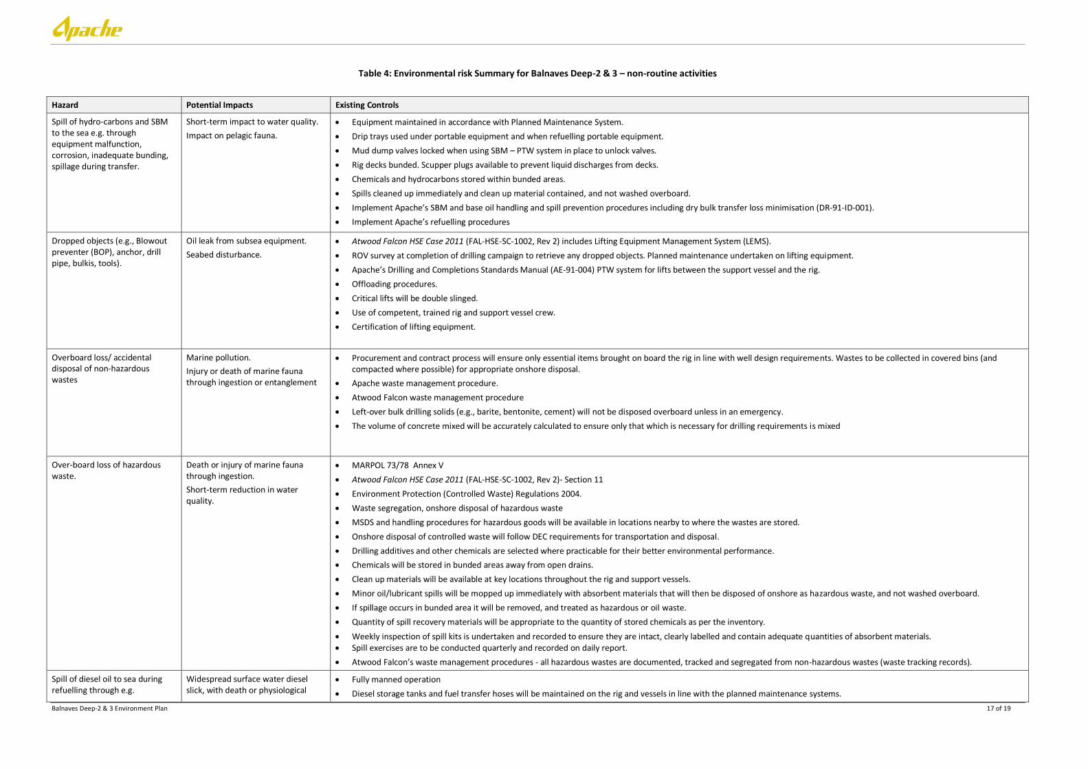
Table 4: Environmental risk Summary for Balnaves Deep-2 & 3 – non-routine activities
Hazard Potential Impacts Existing Controls
Spill of hydro-carbons and SBM to the sea e.g. through equipment malfunction, corrosion, inadequate bunding, spillage during transfer.
Short-term impact to water quality.
Impact on pelagic fauna.
Equipment maintained in accordance with Planned Maintenance System.
Drip trays used under portable equipment and when refuelling portable equipment.
Mud dump valves locked when using SBM – PTW system in place to unlock valves.
Rig decks bunded. Scupper plugs available to prevent liquid discharges from decks.
Chemicals and hydrocarbons stored within bunded areas.
Spills cleaned up immediately and clean up material contained, and not washed overboard.
Implement Apache’s SBM and base oil handling and spill prevention procedures including dry bulk transfer loss minimisation (DR-91-ID-001).
Implement Apache’s refuelling procedures
Dropped objects (e.g., Blowout preventer (BOP), anchor, drill pipe, bulkis, tools).
Oil leak from subsea equipment.
Seabed disturbance.
Atwood Falcon HSE Case 2011 (FAL-HSE-SC-1002, Rev 2) includes Lifting Equipment Management System (LEMS).
ROV survey at completion of drilling campaign to retrieve any dropped objects. Planned maintenance undertaken on lifting equipment.
Apache’s Drilling and Completions Standards Manual (AE-91-004) PTW system for lifts between the support vessel and the rig.
Offloading procedures.
Critical lifts will be double slinged.
Use of competent, trained rig and support vessel crew.
Certification of lifting equipment.
Overboard loss/ accidental disposal of non-hazardous wastes
Marine pollution.
Injury or death of marine fauna through ingestion or entanglement
Procurement and contract process will ensure only essential items brought on board the rig in line with well design requirements. Wastes to be collected in covered bins (and compacted where possible) for appropriate onshore disposal.
Apache waste management procedure.
Atwood Falcon waste management procedure
Left-over bulk drilling solids (e.g., barite, bentonite, cement) will not be disposed overboard unless in an emergency.
The volume of concrete mixed will be accurately calculated to ensure only that which is necessary for drilling requirements is mixed
Over-board loss of hazardous waste.
Death or injury of marine fauna through ingestion.
Short-term reduction in water quality.
MARPOL 73/78 Annex V
Atwood Falcon HSE Case 2011 (FAL-HSE-SC-1002, Rev 2)- Section 11
Environment Protection (Controlled Waste) Regulations 2004.
Waste segregation, onshore disposal of hazardous waste
MSDS and handling procedures for hazardous goods will be available in locations nearby to where the wastes are stored.
Onshore disposal of controlled waste will follow DEC requirements for transportation and disposal.
Drilling additives and other chemicals are selected where practicable for their better environmental performance.
Chemicals will be stored in bunded areas away from open drains.
Clean up materials will be available at key locations throughout the rig and support vessels.
Minor oil/lubricant spills will be mopped up immediately with absorbent materials that will then be disposed of onshore as hazardous waste, and not washed overboard.
If spillage occurs in bunded area it will be removed, and treated as hazardous or oil waste.
Quantity of spill recovery materials will be appropriate to the quantity of stored chemicals as per the inventory.
Weekly inspection of spill kits is undertaken and recorded to ensure they are intact, clearly labelled and contain adequate quantities of absorbent materials. Spill exercises are to be conducted quarterly and recorded on daily report.
Atwood Falcon’s waste management procedures - all hazardous wastes are documented, tracked and segregated from non-hazardous wastes (waste tracking records).
Spill of diesel oil to sea during refuelling through e.g.
Widespread surface water diesel slick, with death or physiological
Fully manned operation
Diesel storage tanks and fuel transfer hoses will be maintained on the rig and vessels in line with the planned maintenance systems.
Balnaves Deep-2 & 3 Environment Plan 18 of 19
Hazard Potential Impacts Existing Controls
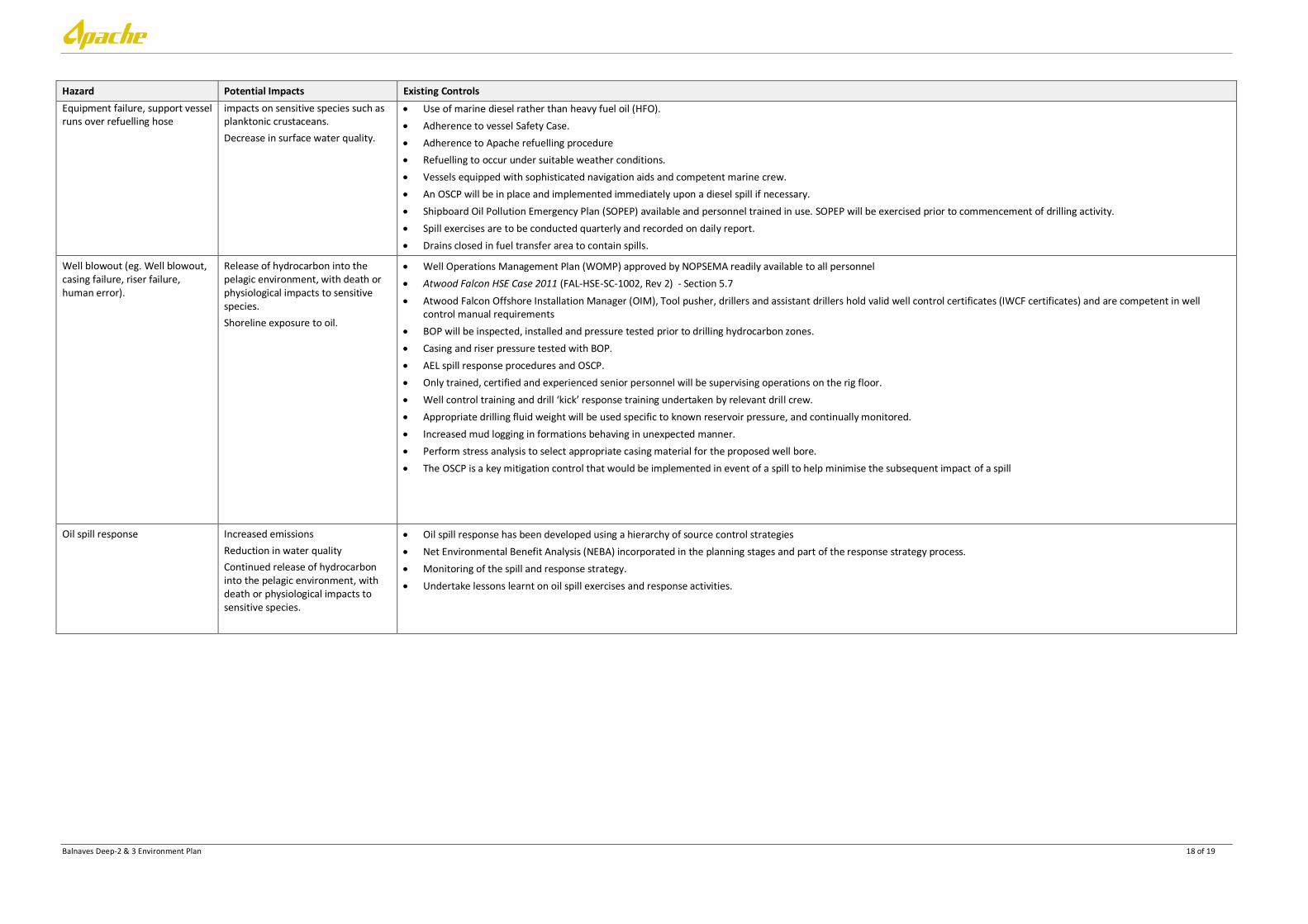
Equipment failure, support vessel runs over refuelling hose
impacts on sensitive species such as planktonic crustaceans.
Decrease in surface water quality.
Use of marine diesel rather than heavy fuel oil (HFO).
Adherence to vessel Safety Case.
Adherence to Apache refuelling procedure
Refuelling to occur under suitable weather conditions.
Vessels equipped with sophisticated navigation aids and competent marine crew.
An OSCP will be in place and implemented immediately upon a diesel spill if necessary.
Shipboard Oil Pollution Emergency Plan (SOPEP) available and personnel trained in use. SOPEP will be exercised prior to commencement of drilling activity.
Spill exercises are to be conducted quarterly and recorded on daily report.
Drains closed in fuel transfer area to contain spills.
Well blowout (eg. Well blowout, casing failure, riser failure, human error).
Release of hydrocarbon into the pelagic environment, with death or physiological impacts to sensitive species.
Shoreline exposure to oil.
Well Operations Management Plan (WOMP) approved by NOPSEMA readily available to all personnel
Atwood Falcon HSE Case 2011 (FAL-HSE-SC-1002, Rev 2) - Section 5.7
Atwood Falcon Offshore Installation Manager (OIM), Tool pusher, drillers and assistant drillers hold valid well control certificates (IWCF certificates) and are competent in well control manual requirements
BOP will be inspected, installed and pressure tested prior to drilling hydrocarbon zones.
Casing and riser pressure tested with BOP.
AEL spill response procedures and OSCP.
Only trained, certified and experienced senior personnel will be supervising operations on the rig floor.
Well control training and drill ‘kick’ response training undertaken by relevant drill crew.
Appropriate drilling fluid weight will be used specific to known reservoir pressure, and continually monitored.
Increased mud logging in formations behaving in unexpected manner.
Perform stress analysis to select appropriate casing material for the proposed well bore.
The OSCP is a key mitigation control that would be implemented in event of a spill to help minimise the subsequent impact of a spill
Oil spill response Increased emissions
Reduction in water quality
Continued release of hydrocarbon into the pelagic environment, with death or physiological impacts to sensitive species.
Oil spill response has been developed using a hierarchy of source control strategies
Net Environmental Benefit Analysis (NEBA) incorporated in the planning stages and part of the response strategy process.
Monitoring of the spill and response strategy.
Undertake lessons learnt on oil spill exercises and response activities.

Balnaves Deep-2 & 3 Environment Plan 19 of 19
10. REFERENCES
Australian Fisheries Management Authority (AFMA) (2010). Annual Report 09/10. Australian Government, Canberra, Australia.
APASA (2011). Julimar Development – Hydrocarbon Spill Risk Assessment Rev 4. Prepared by Asia-Pacific Applied Science Associates, Perth, Western Australia, August 2011.
Apache Energy Ltd (AEL) (2010). Western Australia Kultarr 3D Marine Seismic Survey - Environment Plan. Commonwealth Waters. Document No. EA-00-RI-176. February 2010.
Department of Sustainability, Environment, Water, Population and Communities (DSEWPaC) (2012). Protected matters search tool. Database of fauna listed as Threatened and Migratory Marine Species under the EPBC Act. Department of Sustainability, Environment, Water, Population and Communities. Last accessed for this proposed activity on 23rd January 2012.
Neptune Geomatics (2012). Balnaves Deep-2 site. Final Report prepared for Apache Energy Ltd (Report No; 12A667-RR-001-RO Rev. 0, dated 16 March 2012).
Oracle Risk Consultants (2011). North West Shelf Drilling Environmental Impact Identification Workshop Report (EA-00-RI-190). Report for Apache, 31 October 2011.
Woodside (2005). The Vincent Development. Draft EIS. EPBC Referral 2005/2110.
Woodside (2006). Pluto LNG Development - Draft Public Environment Report / Public Environmental Review EPBC Referral 2006/2968 Assessment No. 1632 December 2006.