Embed Size (px)
Citation preview

BALANCE Interim Report No. 1 i
BALANCE Interim Report No. 1 i
Title
Delineation of BALANCE pilot areas
BALANCE Interim Report No.
1
Date
31 March 2006
Authors
Greger Lindberg (Ed.) Juris Aigars Darius Daunys Kerstin Geitner Martin Isaeus Jonne Kotta Jochen Lamp Jørgen Leth Samuli Neuvonen Alfred Sandstrøm Claus Sparrevohn Thomas Kirk Sørensen Ole Vestergaard
Approved by
Greger Lindeberg
Front page illustration: Karsten Dahl, NERI
1 Final report GL JHA/JYR GL 31/3-06
0 Draft report GL JHA
Revision Description By Checked Approved Date
Key words
BALANCE; Baltic Sea; Kattegat; Skagerrak, marine landscapes; habitats
Classification
Open
Internal
Proprietary
Distribution No of copies
BALANCE Secretariat BALANCE partnership BSR INTERREG IIB Joint Secretariat Archive
3 + pdf 20 + pdf
1 1

BALANCE Interim Report No. 1 ii
CONTENTS
0 PREFACE....................................................................................................................... 1
1 PILOT AREA 1................................................................................................................ 2 1.1 Case study 1A: Northern Skagerrak / Southern coast of Norway................................... 2 1.2 Case study 1B: Northern Kattegat .................................................................................. 5
2 PILOT AREA 2................................................................................................................ 7 2.1 Case study 2A: Offshore fish habitats / The Bornholm Deep ......................................... 7 2.2 Case study 2B: Adler Ground ......................................................................................... 8
3 PILOT AREA 3.............................................................................................................. 12 3.1 The Archipelago Sea .................................................................................................... 12 3.2 The Swedish Archipelago ............................................................................................. 14 3.3 Åland Island .................................................................................................................. 15 3.4 The case study areas ................................................................................................... 16
4 PILOT AREA 4.............................................................................................................. 18 4.1 Case study 4A: Väinameri Archipelago Sea................................................................. 18 4.2 Case study 4B: Northern part of the Lithuanian coastal waters.................................... 20 4.3 Case study 4C: Baltic proper Latvian coastal waters ................................................... 20
5 REFERENCES ............................................................................................................. 22 Appendix 1: All uses and spatial claims in the German EEZ in the Baltic Sea

BALANCE Interim Report No. 1 1
0 PREFACE
This report describes in details the delineation of the 4 BALANCE Pilot Areas:
• Pilot area 1 includes the Kattegat and Skagerrak which have a very high diversity of marine species and contain many unique habitats. The planned BALANCE activities are to be carried out by partners from Denmark (DIFRES, GEUS, NERI) and Swe-den (SBF) as well as two Norwegian sub-contractors (NGU and NIVA).
• Pilot area 2 is an area in the central Baltic Sea surrounding the Danish island of Bornholm. The pilot area consists mainly of marine areas within the EEZs of Ger-many, Denmark and Sweden. The planned BALANCE activities are to be carried out by partners from Denmark (DIFRES and GEUS) and Germany (WWF).
• Pilot area 3 is the northern most of the 4 areas and includes the The Archipelago Sea, The Swedish Archipelago and the Åland Sea around the Åland Islands. The ac-tivities within this pilot area are to be carried out by the Swedish National Board of Fisheries (SBF), Metria, the Swedish Environmental Protection Agency (SEPA), County Administrative Board of Stockholm (CABS), Metsähallitus (MH), Geologi-cal Survey of Finland (GSF) and Finnish Environment Institute (SYKE).
• Pilot area 4 covers the Gulf of Riga as well as the coastal water of Latvia and Lithuania. The planned BALANCE activities within pilot area 4 are to be carried out by partners from Estonia (EMI), Latvia (UL) and Lithuania (CORPI).
The BALANCE activities in the pilot areas shall lead to the development of generic tools and guidelines for marine spatial planning in the Baltic Sea. In a longer perspec-tive, the management practices should improve in order to better safeguard and protect marine resources.
More information about BALANCE can be found at http://www.balance-eu.org.
Greger Lindberg, WP1 coordinator
The Geological Survey of Sweden
BALANCE Interim Report No. 1 2
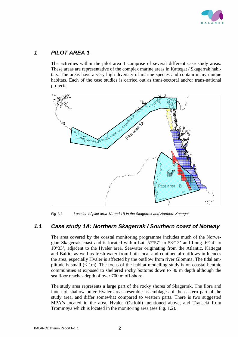
1 PILOT AREA 1
The activities within the pilot area 1 comprise of several different case study areas. These areas are representative of the complex marine areas in Kattegat / Skagerrak habi-tats. The areas have a very high diversity of marine species and contain many unique habitats. Each of the case studies is carried out as trans-sectoral and/or trans-national projects.
Fig 1.1 Location of pilot area 1A and 1B in the Skagerrak and Northern Kattegat.
1.1 Case study 1A: Northern Skagerrak / Southern coast of Norway
The area covered by the coastal monitoring programme includes much of the Norwe-gian Skagerrak coast and is located within Lat. 57°57’ to 58°12’ and Long. 6°24’ to 10°33’, adjacent to the Hvaler area. Seawater originating from the Atlantic, Kattegat and Baltic, as well as fresh water from both local and continental outflows influences the area, especially Hvaler is affected by the outflow from river Glomma. The tidal am-plitude is small (< 1m). The focus of the habitat modelling study is on coastal benthic communities at exposed to sheltered rocky bottoms down to 30 m depth although the sea floor reaches depth of over 700 m off-shore.
The study area represents a large part of the rocky shores of Skagerrak. The flora and fauna of shallow outer Hvaler areas resemble assemblages of the eastern part of the study area, and differ somewhat compared to western parts. There is two suggested MPA’s located in the area, Hvaler (Østfold) mentioned above, and Transekt from Trommøya which is located in the monitoring area (see Fig. 1.2).

BALANCE Interim Report No. 1 3
Fig 1.2 Skagerrak bathymetry, Norwegian coastal monitoring stations and suggested MPA’s.
The areas south of Hvaler/Koster are topographically complex with rocky elevations surrounded by moraine remnants, coarser and fine sediments. Deeper areas are domi-nated by fine sediments except at sites where currents sweep away fine particles; witch is often the case at elevations. Fig. 1.3 gives an overview of maximum current fields by the sea floor in Skagerrak and surrounding sea areas. The resolution of the current grid is 4×4 km and the current patterns in areas of complex topography are not fully de-scribed. However, it shows that benthic currents are comparably strong in the area and should be considered during modelling of benthic habitats. Deeper areas off the coast have generally less complex bathymetry and are often covered by fine sediments.
Fig 1.3 Maximum speed (knots) of current fields by the seafloor based on weekly means during 2004 (Source: Morten D. Skogen, Havforskningsinstituttet, Norway).

BALANCE Interim Report No. 1 4
The extension of the case study area is not finally set since all input data is not yet available. A study on sediment bottoms will include areas south of the rectangle shown in figure 1.2.
The eastern parts of the area in the northern Skagerrak (Koster-/Väderöfjorden and Sin-glefjorden) are situated in Swedish territorial waters and the western part (Yttre Hvaler) is situated in Norwegian territorial waters. Koster-Väderöfjorden (~426 km2), has been declared a Natura 2000 area according to the EC Habitats Directive.
The water depth of the area varies from 260 m in the deepest part of the trench to depths of <50 m towards the coast, with the major part of the area being ~200 m deep. The study area includes Rauøy fjorden, which has been an undisturbed area for the past dec-ades, as no fishing or other activities have been allowed.
The central position of Kosterfjorden/Yttre Hvaler is app. 58°58,70 N and 11°01,60 E (Fig. 1.4). The Kosterfjorden/Yttre Hvaler can be considered to be representative for Skagerrak habitats and species. The area has a very high diversity of marine species and contains many unique habitats and species that can not be found elsewhere in Sweden or this part of Norway, e.g. deep (>200m) soft and hard bottoms, very exposed shallow sediments and rocks and deep water coral reefs, dominated by Lophelia pertusa. It is an important area for a great variety of invertebrates, fishes, sharks and seals.
Fig 1.4 The central position of Kosterfjorden/Yttre Hvaler.
The area also hosts internationally important numbers of seabirds. Based on acoustic surveys performed at The Yttre Hvaler area by The Norwegian Geological Survey high-resolution seabed morphology and sediments distribution maps are produced. These data will be integrated with comparable data from the Swedish Koster area. These maps combined with supplementary in-fauna sample stations, SPI measurements (sediment profile index) and ROV stations comprise the data set used for the habitat modelling work of the study area.

BALANCE Interim Report No. 1 5
1.2 Case study 1B: Northern Kattegat
NERI and GEUS will conduct studies in the northern Kattegat for the mapping and modelling of hard bottom habitats as well as soft bottom in the pilot area 1.
Hard bottom habitats (NERI, GEUS, SGU): From the 10 years monitoring programme conducted by NERI at the boulder reef area Kim’s Top biodata including macro-algae vegetation and the cover of large macro-fauna organism a total vegetation cover model has been developed. Moreover a newly recognised adjacent boulder reef indicates that more stone reefs can be predicted in the area on the basis of acoustic data.
The study will be based on acoustical data sets (multibeam and sidescan sonar data) ac-quired by GEUS around the island of Læsø and for the northern Kattegat acquired by The Royal Danish Administration of Navigation and Hydrography, intercalibrated with similar data sets from the adjacent Swedish waters. The analysis will focus on water depths similar to Kim’s top (14-23 m) and areas of the same structuring variables for biological components like salinity, temperature, water transparency, nutrient level etc. Based on back scatter and bathymetry data the analysis of the seabed morphology and the seabed sediment distribution, hard bottom areas will be identified and mapped throughout the area from Kim’s Top to north-east of Læsø.
Subsequently NERI will verify the geologically identified reefs on the basis of their bio-logical components. Data sampling will take part in areas mapped by acoustic surveys in close co-operation with GEUS. The fieldwork continues in order to intercalibrate ex-isting data sets and to enable the production of reliable habitat maps and predictive models. This includes analysis of sample data and statistical analysis of results. The data will be used for validating the marine landscapes and habitat maps in MS4.
Soft bottom habitats (NERI, GEUS): The study focuses on mapping different communi-ties on the soft bottom on the basis of integrating acoustic methods with sediment sam-pling. The scope of the study is to test if the acoustic methods can help to define a num-ber of soft bottom classes. As a preliminary action the exact study area will be selected based on the analysis of existing acoustic data sets representing a specific sloped area with a gradually changed composition of soft sediment. Due to the fact that no sediment data are available beforehand the selected area subsequently will be sampled during a field campaign and analysed to test the hypothesis.
Eelgrass beds (NERI): The activity will map the distribution/existence of eelgrass beds at the sand flats south of Læsø. The analysis will test the applicability of “air-photos” taken from airplane or/and satellite images to the mapping of eelgrass beds. The data availability and quality needs further evaluation.
The Danish Institute for Fisheries Research has a long history in the field of nursery habitats and habitats requirements for marine juvenile flatfish. This expertise, combined with existing data, including a time series, will be used to set up a predictive model for nursery habitats for different flatfish species along the north-eastern coast of Jylland from Skagen (N56º70; E10º72) to Djursland (N56º44; E11º00). The model will predict the abundance of the most common species such as plaice and sole from a range of pa-rameters like, depth, bottom sediment, spring sea surface temperature, nutrition load, wind etc.
BALANCE Interim Report No. 1 6
The available time series for this case study has been gathered since the early 1950 where an annual survey (except the years 1971-1985) was started. The survey was originally designed to focus on catching juvenile plaice, as this was historical one of the major commercial species in the Danish fishery. During the year’s changes in species composition and abundances has been observed but so fare not tightly connected to any changes in habitat parameter.
For many commercial important flatfish species the total available habitat that juveniles can utilize as nursery grounds is closely coupled to the later stock size. Therefore deg-radation and changes in these areas will not only affect the inhabitants but the entire ecosystem of the Kattegat. Depth is one of the factors limiting the size of the nursery area and it is known that different species has different depth limits, but in general the nursery habitats for flatfish are characterized by being shallow. Therefore, there is in many cases little spatial overlap between the adult and the juvenile population and for most species the spawning take places in an entirely different area than the nursery habi-tat. In this project the juvenile will be coupled to the adult population through a hydro-graphical model predicting where along the coastline eggs spawned at a given time at a given location will eventually end up.

BALANCE Interim Report No. 1 7
2 PILOT AREA 2
Pilot area 2 is an area in the central Baltic Sea surrounding the Danish island of Born-holm. The pilot area consists mainly of marine areas within the EEZs of Germany, Denmark and Sweden, albeit the Danish territorial waters surrounding Bornholm are in-cluded (see Fig. 2.1).
Fig 2.1 Pilot area 2. Case study area 2A: mapping of offshore fish habitats (cod spawning based on biological and hydrographic information. Case study area 2B: Transnational offshore, multi-ple-use area (zoning of e.g. potential conservation, energy, geological resources, fisheries interests).
2.1 Case study 2A: Offshore fish habitats / The Bornholm Deep
Case study area 2A, to the east of Bornholm, is an area in which the main focus in BALANCE will be the distribution of adult and early life-stages of Baltic cod (Gadus morhua) in relation to the physical environment.
Case study area 2A includes the Bornholm Deep, an appr. 80 m deep basin that is one of the main spawning areas for Baltic cod (e.g. Köster et al. 2005). Baltic cod use separate locations and habitats for spawning, larval development, juvenile and adult feeding (Fig. 2.2). The Baltic cod’s complex life history provides a challenge for management and conservation, since it requires a successful temporal and spatial linkage between these locations to integrate the whole life-cycle and produce abundant generations of cod.

BALANCE Interim Report No. 1 8
Eas tern Baltic stockWestern Baltic stock
Spawning areaNursery areaDrift of young fishSpawning migration
Eas tern Baltic stockWestern Baltic stock
Spawning areaNursery areaDrift of young fishSpawning migration
Fig 2.2 Distribution of spawing and nursery areas of cod in the Baltic Sea (Aro 2000, redrawn from Bagge et al. 1994).
As a consequence, past and current attempts at temporal and/or spatial restriction of ar-eas to conserve and improve cod stocks have not had significant impacts. For instance, the seasonal or permanent closure of an area to fisheries may be of limited use in en-hancing spawning opportunities for mobile fish (e.g. Baltic cod in the Bornholm Deep / Case study area 2A) if the reduction in catches is compensated by increased catches in neighbouring areas or other seasons (e.g. Walters 2000; Suuronen & Lowry 2003). To be effective in reducing the overall fishing mortality on pre-spawning cod, the closure of a sea area to cod-directed fishery must be designed to take into account the distribu-tion, life histories and migration patterns of target species as well as the adaptive re-sponses of fishing fleets.
2.2 Case study 2B: Adler Ground
Adler Ground is part of the Pomeranian Bay in the south-western Baltic Sea. It is an offshore area in the EEZs of Denmark and Germany. The Pomeranian Bay in general is one of the ecologically most important areas in the Baltic Sea. Sandbanks, banks of blue mussels and reefs are sensitive habitats with their adapted species-rich communities. These habitats are important feeding grounds for diving seabirds - over a million sea-birds winter in the area - and as nursery grounds for several fish species. The area is also of likely importance as feeding area and stepping stone for the eastern population of the endangered Harbour Porpoise (Phocoena phocoena).
The reef and sandbank complexes of the Pomeranian Bay are highly representative for the Baltic Sea. The reefs consist of submarine rocky substrates and biogenic concretions

BALANCE Interim Report No. 1 9
which arise from the sea-floor into the sublittoral zone and comprise diverse habitats and structures.
Fig 2.3 Several different sediment types can be found in the Adler Ground area.
Adler Ground covers sandbanks as well as stone and maerl reefs partially covered with thick meadows of the brown algae Chorda tomentosa and blue mussel (Mytilus edulis) in a depth of 20–7 meters. Typical algae in the shallow zone are Fucus serratus and Furcellaria lumbricina. The habitats comprise about 45 species of makrozoobenthos. Several sediment-types can be found within the limits of Adler Ground (Fig. 2.3), giv-ing rise to the potential representation of a wide variety of associated biological com-munities within a limited geographical area (Sørensen 2005).
The ridge of the Western Rønnebank reaches depths of about 40 meters. It consists of unspoilt stone fields forming reefs that provide habitats for a remarkable number of macrozoobenthos, in total 68 taxa were proven, e.g. Halitholus yoldia-arcticae (Hydro-zoa), Tridonta borealis (Bivalvia) and Theodoxus fluviatilis (Gastropoda).
Table 2.1 Dominant species on Adler Ground.
Taxon Presence % Ind./qm Mytilus edulis 88 2.082 Pygospio elegans 91 765 Hydrobia ulvae 79 264 Clitellio arenarius 56 170 Macoma balthica 94 141 Heterochaeta costata 69 96 Hediste diversicolor 86 88 Tubificoides benedii 63 62 Gammarus salinus 59 49 Mya arenaria 47 47
BALANCE Interim Report No. 1 10
The Harbour Porpoise is internationally recognised as endangered and is the object of many protection efforts. There is strong evidence that there is a central Baltic Sea sub-population of about 600 individuals, which is genetically different from the Western Baltic population. Especially high concentrations of Harbour porpoises have been ob-served in the Pomeranian Bay (2002) on the Odra Bank and Adler Ground.
The Pomeranian Bay is the second most important wintering area in the Baltic Sea. Over 1 million seabirds can be seasonally found. Especially significant is the area for the Velvet Scooter (Melanitta fusca), Red-necked Grebe (Podiceps grisegena) and Sla-vonian Grebe (Podiceps autitus). Ten species occur in numbers of international impor-tance, including the Long-tailed Duck (Clangula hyemalis) and the Common and Velvet Scooter (Melanitta nigra and M. fusca). There is an isolated eastern population of about 25.000 individuals of the Black Guillemot in the Baltic Sea. About 1000 individuals of the possible subspecies are found in the area of Adler Ground. In addition, Adler Ground is an important place of refuge for the seabirds when the southern and central Pomeranian Bay freezes up in cold winters.
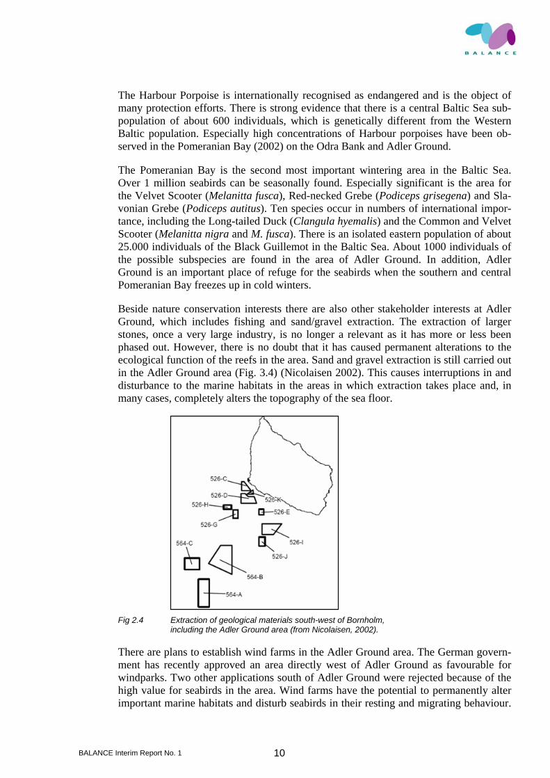
Beside nature conservation interests there are also other stakeholder interests at Adler Ground, which includes fishing and sand/gravel extraction. The extraction of larger stones, once a very large industry, is no longer a relevant as it has more or less been phased out. However, there is no doubt that it has caused permanent alterations to the ecological function of the reefs in the area. Sand and gravel extraction is still carried out in the Adler Ground area (Fig. 3.4) (Nicolaisen 2002). This causes interruptions in and disturbance to the marine habitats in the areas in which extraction takes place and, in many cases, completely alters the topography of the sea floor.
Fig 2.4 Extraction of geological materials south-west of Bornholm,
including the Adler Ground area (from Nicolaisen, 2002).
There are plans to establish wind farms in the Adler Ground area. The German govern-ment has recently approved an area directly west of Adler Ground as favourable for windparks. Two other applications south of Adler Ground were rejected because of the high value for seabirds in the area. Wind farms have the potential to permanently alter important marine habitats and disturb seabirds in their resting and migrating behaviour.
BALANCE Interim Report No. 1 11
The favourable construction sites are sandbanks in shallow water, but these are also of highest value for the biodiversity especially for diving birds of the Baltic Sea.
Fisheries also have a high interest in the area at Adler Ground, and stakeholder conflicts can occur with e.g. nature conservation interests in the area. Especially high densities of bottom gillnets constitute a permanent risk for seabirds and mammals. The impact of fisheries includes the exploitation of stocks of commercial as well as non-commercial species, of seabirds and marine mammals through unintended by-catch.
In case of an accident, oil pollution would have a devastating effect on seabirds and fishing grounds. Impacts and threats from dumped World War II munitions need to be investigated.
Germany has designated three Natura2000 sites within the proposed “Pomeranian Bay” area: Oderbank and Adler Ground nominated as SAC and almost the whole German part of the bay as bird protection area (SPA). In September 2005 Germany also pro-tected the Pomeranian Bay as a nature reserve under national legislation. The area also has international importance in the framework of the HELCOM BSPA network (Baltic Sea Protected Areas) and in the light of the ASCOBANS’s Jastarnia plan (to safeguard the Baltic Harbour Porpoise population).
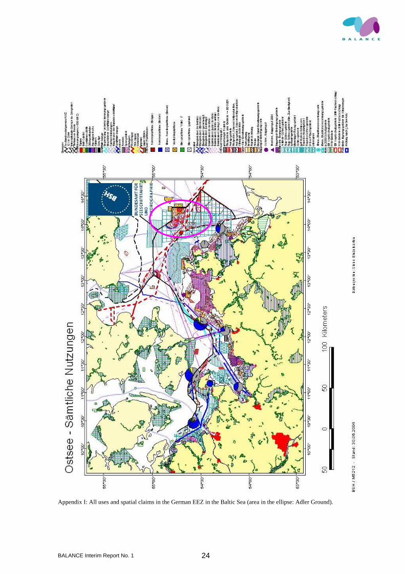
Numerous expectations and sea-use claims ranging from nature conservation, resource use for fisheries and mineral extraction to shipping and offshore installations must be dealt with during the development of a zoning concept for the Adler Ground case study, an area with typical offshore and trans-national characteristics (see App. 1).
BALANCE Interim Report No. 1 12
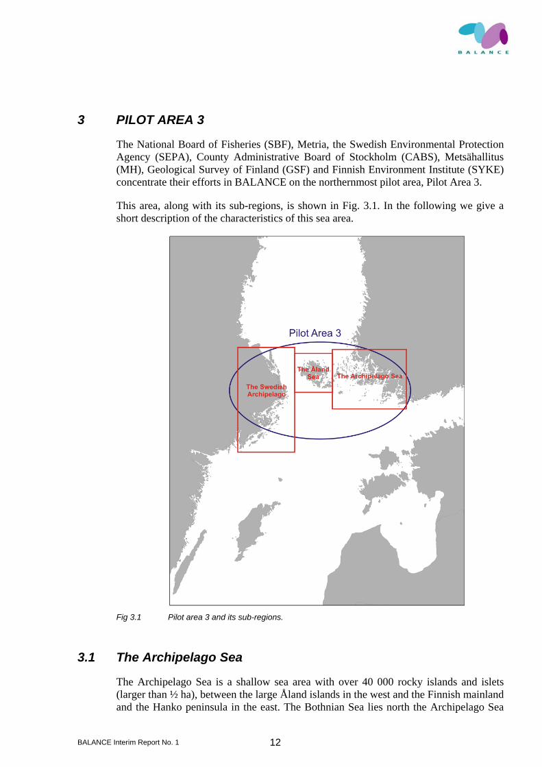
3 PILOT AREA 3
The National Board of Fisheries (SBF), Metria, the Swedish Environmental Protection Agency (SEPA), County Administrative Board of Stockholm (CABS), Metsähallitus (MH), Geological Survey of Finland (GSF) and Finnish Environment Institute (SYKE) concentrate their efforts in BALANCE on the northernmost pilot area, Pilot Area 3.
This area, along with its sub-regions, is shown in Fig. 3.1. In the following we give a short description of the characteristics of this sea area.
Fig 3.1 Pilot area 3 and its sub-regions.
3.1 The Archipelago Sea
The Archipelago Sea is a shallow sea area with over 40 000 rocky islands and islets (larger than ½ ha), between the large Åland islands in the west and the Finnish mainland and the Hanko peninsula in the east. The Bothnian Sea lies north the Archipelago Sea

BALANCE Interim Report No. 1 13
with the Northern Baltic Sea Proper to the south. The environment of the archipelago is the result of a continuous land uplift (4 mm/year); small islets have been transformed into big islands and finally to parts of the growing mainland. The water depth, exposure of the shore, sea bottom type and many other environmental factors vary even within small areas. Together with the strongly meandering shoreline this results in an archipel-ago of extremely varied natural environments.
Even though the area is quite shallow (average depth about 23 m), the bottom topology is mostly steep and even in the inner parts of the archipelago there are deeps that reach over 90 meters. The deepest areas in the Archipelago Sea are over 100 meters deep and the highest islands are about 40 meters above the sea level. While most islands are rocky, some are of glacio-fluvial origin: eskers, clay deposits, potholes, end moraines and ice-marginal formations. Because of the deep channels between the islands, most of the water exchange between the Bothnian Sea and the Baltic Proper occurs through the Archipelago Sea. The main current in the Archipelago Sea runs from southeast to north, from the Gulf of Finland to the Bothnian Bay. The Archipelago Sea is essentially tide-less, but irregular water level fluctuations of up to 1 m occur due to winds and atmos-pheric pressure gradients.
The shallowness and the rugged seafloor topography diminish water exchange between the archipelago and the open sea areas (Mälkki et al., 1979). Sea bottom oxygen defi-ciency is common in the areas of poor bottom water exchange (Virtasalo et al. 2005). The sedimentation pattern is very complicated due to the glacio-isostatic land uplift (Mäkinen & Saaranen 1998), resulting continuous change between the areas of accumu-lation, transportation and erosion. The seafloor is a patchy combination of various sub-strates like bedrock, moraine formations (till), gravel and sand, clays of different ages (hard and soft) as well as very soft mud (Häkkinen, 1990).
The area of the Arhipelago Sea can be divided into certain archipelago zones (coastal zone, inner archipelago, outer archipelago and open sea zone) based on the exposure, shore type and vegetation. The innermost coastal zone is comprised mostly of large is-lands covered by forests (coniferous to mixed forests with pine, fir, birch and alder) and sheltered, narrow water passages. Much of the shoreline is vegetated with reeds. In the inner archipelago, the proportion of water-covered area grows, but is still smaller than the proportion of land. Islands continue to have forest cover close to the shoreline and sheltered bays are lined by reeds.
In the outer archipelago, there are fewer islands and they are smaller in size. Water ar-eas are dominant and islands form small groups separated by open water. Small islands are without trees, even though there are still many larger forested islands. The shores are rocky and without vegetation. Further out, in the open sea zone, there are only small skerries and sand ridges without any trees.
Changes in the ice conditions are depending on the archipelago zone rather than on the latitude. Ice covers the inner and middle parts of the Sea practically every winter from January to April. Only during colder winters the outer archipelago is covered by strong ice (late January - March). The average number of ice days in the outer regions is 20-60, in the inner archipelago 80-100 and in the coastal zone 100-120.
BALANCE Interim Report No. 1 14
The Archipelago Sea is the most saline of the Finnish sea areas with a surface salinity varying from 5 to 7 PSU. The number of aquatic species adapted to these brackish con-ditions is rather low, but the biological diversity is high compared to the surrounding sea areas. In addition, the species-specific populations are large, indicating a vigorous and rich environment. Of the 187 species (Aaltojen alla, 2006) in the area, about 50 are of oceanic origin.
The vegetation of the steep rocky shores is also zonal. Fucus vesiculosus beds are clos-est to the surface, from less than 1 meter to 4-6 meters. However, F. vesiculosus has disappeared from large areas due to eutrophication, and has been replaced by filamen-tous algae (e.g. Cladophora glomerata). Below this zone filamentous macroalgae, mainly Furcellaria lumbricalis, Sphacelaria arctica and Phyllophora pseudocera-noides, dominate up to 15-20 m. Hildenbrandia rubra and Pseudolithoderma can grow even below 20 meters. In areas of clear water, vascular plants (such as Potamogeton perfoliatus and Zannichellia major) are often encountered also below the F. vesiculosus zone. Fields of Zostera marina can be found here and there in the sandy areas of the outer archipelago.
Typical fish species are the Baltic herring (Clupea harengus), pike (Esox lucius), white-fish (Coregonidae), perch (Perca fluviatilis) and flounder (Platichthys flesus). Endan-gered species found in the Archipelago Sea include White-tailed eagle (Haliaeetus albi-cilla), Caspian tern (Sterna caspia), Greater scaup (Aythya marila) and Ringed seal (Phoca hispida).
3.2 The Swedish Archipelago
The Swedish part of BALANCE pilot area 3 covers the vast archipelago area in the counties of Södermanland, Stockholm and Uppsala. The archipelago area is about 300 km long and up to 100 km wide. The Swedish archipelago is separated from the Åland archipelago by a narrow strait, about 10 km wide and 50 m deep at the shallowest part. North of the sill the water is mainly influenced by freshwater discharges from both the Bothnian Bay and Bothnian Sea, while south of the sill the water is more influenced by the conditions in the Baltic Sea Proper.
The archipelago area with tens of thousands of islands is topologically and geologically very heterogeneous, and the habitats are therefore usually small, with a very complex mix of soft and hard substrates. Modelling this patchy distribution of habitats is a chal-lenge, and to succeed in making accurate habitat maps detailed data on the physical en-vironment is needed.
The land rise is 4-6 mm per year, and is continuously changing the landscape, turning shallow sheltered inlets into lakes, eventually cutting them off from the sea. The succes-sion in these bays and inlets allows for highly dynamic and heterogeneous environ-ments, resulting in high biodiversity. There are strong salinity gradients in the pilot area, both in a north-south direction as well as from the inner archipelago to the outer parts. The salinity in the outer archipelago varies from around 5 PSU in the northern parts to around 7 in the south. In the innermost bays and fladas the salinity may get down to 3-4 PSU or sometimes even further, depending on inflow of freshwater. Since many marine

BALANCE Interim Report No. 1 15
as well as freshwater organisms have their distribution limits at these salinities, this gra-dient, together with a similar gradient in wave exposure largely shapes the biota.
The maximum depth for vegetation differs depending on light attenuation, ranging from around 2 to 10 m, with the shallowest maximum depth in the inner parts. This is mainly influenced by nutrient runoff from land, which has a strong effect on the biota. This be-comes increasingly evident in more densely populated parts of the archipelago, e.g. the Stockholm area.
Water temperature and ice cover also varies between the inner and outer parts of the ar-chipelago. The inner parts warm up earlier than the seaward areas, and cool down ear-lier in the autumn. Since fish are very sensitive to temperature, the dynamics of tem-perature variations has a large influence on fish migrations within the area. Many coastal fish species, such as pike, perch and sander (Sander lucioperca) need warm wa-ter for reproduction, and therefore use more shallow, sheltered and, thus warmer parts of the archipelago as nursery areas. Also fish like turbot (Psetta maxima), flounder, white-fish and herring utilize the productive coastal areas for spawning. The adults of these species prefer cold water, and therefore migrate to the outer parts of the archipelago when the water in the inner parts gets to warm in summer.
3.3 Åland Island
The Åland main island and its archipelago lie in the middle of the northern Baltic Sea between the Archipelago Sea of Finland and the Swedish east coast. The region covers the eastern part of the Archipelago Sea and the Åland Sea rendering the area physico-chemical, topological and geological features much alike the two other sub-regions of the study area. Also the flora and fauna of the region show great similarities. The island lack larger runoffs, which result in only a low influence of freshwater on the marine en-vironment, and restricting it to the innermost parts of the archipelago. The sill at the bot-tom of the deep Baltic Proper extending from the island of Utö in the south-eastern part towards the west influences the hydrographical conditions of the region, especially the salinity. The conditions are further influenced by the two currents of opposite direction that as a result of the Coriolis Effect runs in the western and eastern parts, respectively. In the east, the current has a south-north direction whereas as in the west, the direction is from north to south. As a consequence of these two circumstances, the salinity is lower in the western part compared with the eastern part of the region. The archipelago is characterised by rocky shores and numerous island and skerries, and it comprises of over 9800 island larger than 0.5 ha in area. It shows a great variation in degree of expo-sure as well as human influence, such as shoreline exploitation and navigational activi-ties. The north-western part has a clear inner-outer gradient with a heterogeneous archi-pelago landscape of different sized islands, skerries and characteristic elongated large bays. The northern parts of the archipelago are less wide and highly exposed to the north by the Bothnian Sea. This part of the archipelago is less influenced by human im-pact. The western and south-western parts are almost lacking island and are directly ex-posed to the Åland Sea and the Baltic Proper. The eastern and south-eastern parts are widespread and topographically less variable with the islands and bays of differing size. Especially the south-eastern part is highly influenced by navigational activities.
BALANCE Interim Report No. 1 16
3.4 The case study areas
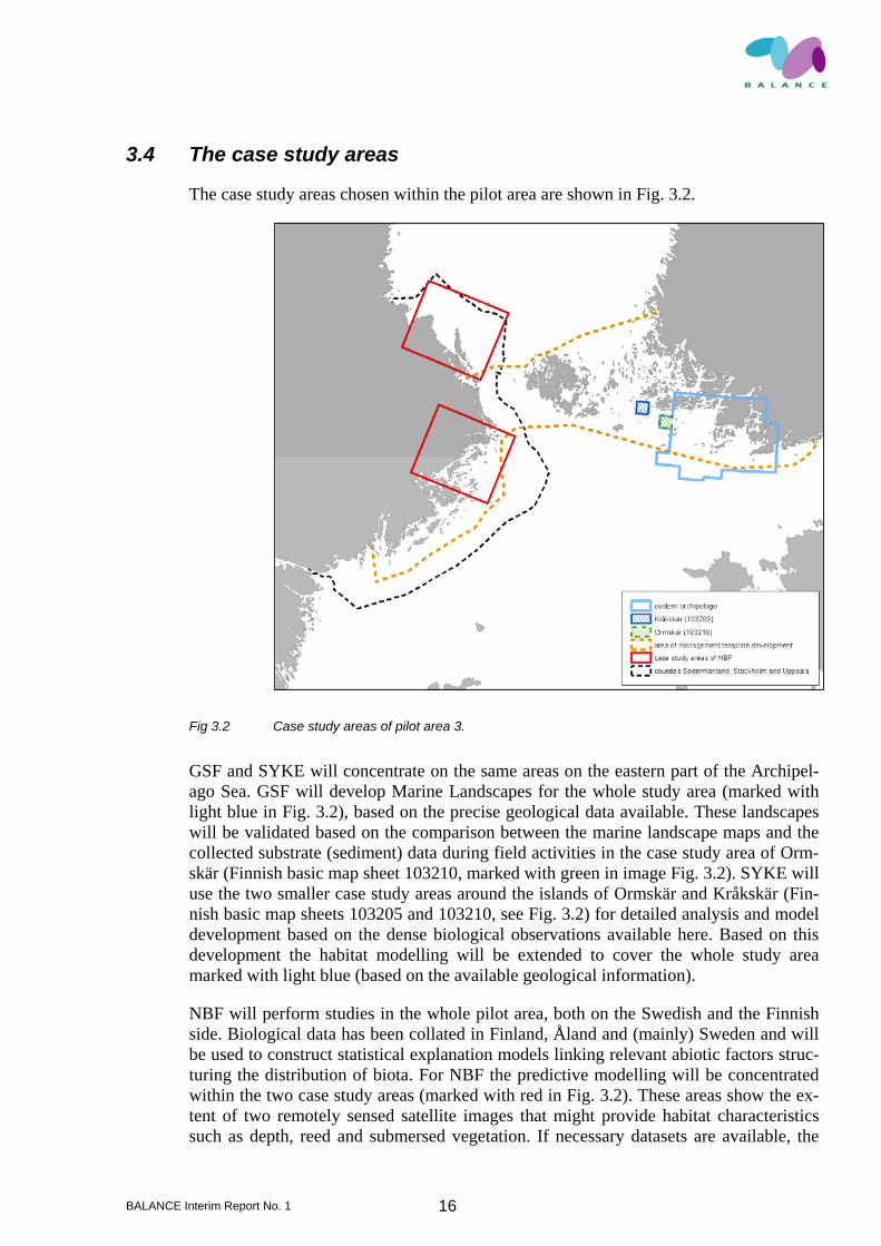
The case study areas chosen within the pilot area are shown in Fig. 3.2.
Fig 3.2 Case study areas of pilot area 3.
GSF and SYKE will concentrate on the same areas on the eastern part of the Archipel-ago Sea. GSF will develop Marine Landscapes for the whole study area (marked with light blue in Fig. 3.2), based on the precise geological data available. These landscapes will be validated based on the comparison between the marine landscape maps and the collected substrate (sediment) data during field activities in the case study area of Orm-skär (Finnish basic map sheet 103210, marked with green in image Fig. 3.2). SYKE will use the two smaller case study areas around the islands of Ormskär and Kråkskär (Fin-nish basic map sheets 103205 and 103210, see Fig. 3.2) for detailed analysis and model development based on the dense biological observations available here. Based on this development the habitat modelling will be extended to cover the whole study area marked with light blue (based on the available geological information).
NBF will perform studies in the whole pilot area, both on the Swedish and the Finnish side. Biological data has been collated in Finland, Åland and (mainly) Sweden and will be used to construct statistical explanation models linking relevant abiotic factors struc-turing the distribution of biota. For NBF the predictive modelling will be concentrated within the two case study areas (marked with red in Fig. 3.2). These areas show the ex-tent of two remotely sensed satellite images that might provide habitat characteristics such as depth, reed and submersed vegetation. If necessary datasets are available, the
BALANCE Interim Report No. 1 17
explanation models can then be exported to the whole of the vast Swedish archipelago area in the counties of Södermanland, Stockholm and Uppsala. Metsähallitus will also work on both the Swedish and Finnish areas to develop management templates and guidelines. Their study area is marked with dashed orange line in image 2. The area consists of the county of Stockholm, Sweden, extending through the Archipelago Sea, including the part of the Gulf of Finland west to the western border of the municipality of Inkoo, and up along the coastline to the altitude of municipality of Nystad. The bounding coordinates of the study areas are given in Tab. 3.1.
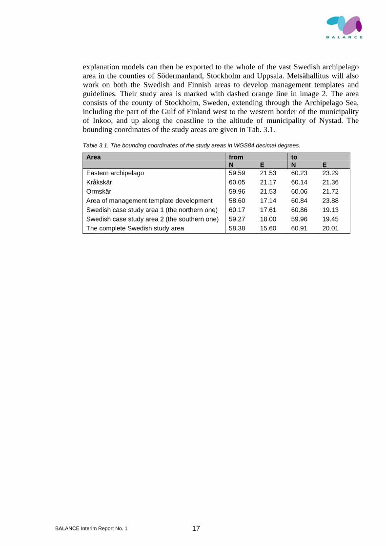
Table 3.1. The bounding coordinates of the study areas in WGS84 decimal degrees.
Area from to N E N E Eastern archipelago 59.59 21.53 60.23 23.29 Kråkskär 60.05 21.17 60.14 21.36 Ormskär 59.96 21.53 60.06 21.72 Area of management template development 58.60 17.14 60.84 23.88 Swedish case study area 1 (the northern one) 60.17 17.61 60.86 19.13 Swedish case study area 2 (the southern one) 59.27 18.00 59.96 19.45 The complete Swedish study area 58.38 15.60 60.91 20.01

BALANCE Interim Report No. 1 18
4 PILOT AREA 4
The Gulf of Riga is a relatively shallow and isolated water-body. On eastern and south-ern sides it is surrounded by Estonian and Latvian mainlands and on the northern side by Saaremaa and Muhu islands. The Gulf of Riga is connected to the Baltic Proper via the Irbe Strait and to the Väinameri Archipelago Sea by the Suur Strait. Annual river in-flow ranges between 18 and 56 km3 (an average 32 km3) while the volume of the gulf is 424 km3. Residence time of the water masses is 2–4 years. The Gulf of Riga receives fresh water from a huge drainage area and the majority of it enters the southern part of the basin. In general, the bottom relief of the area is quite flat with gentle slopes towards deeps. The northern part of the gulf is characterized by a wide coastal zone with diverse bottom topography and extensive reaches of boulders. The southern part of the Gulf of Riga is more exposed, steep and soft substrate prevails. In the deeper parts of the gulf silty sediments prevail.
The average salinity of the Gulf of Riga varies from 0.5–2 PSU in surface layers in its southern and north-eastern areas to 7 PSU at the Irbe Strait. In most parts of the gulf the salinity is 5–6.5 PSU. During the ice-free season the salinity is higher in the bottom lay-ers and lower in the surface layer. However, due to its shallowness the Gulf of Riga lacks a permanent halocline.
As the Gulf of Riga is a shallow water basin the changes in air temperature have a direct influence on the dynamics of both surface and deep water. In a “typical” year the water is cold and no clear thermocline occurs till May. Later the surface water temperature raises to about 17–20ºC and a thermocline builds up. The water temperature below 30 m remains relatively stable at 3ºC. The thermocline reaches a depth of 25 m in August and disintegrates in September–October due to intensive wind mixing. In the course of au-tumn storms the surface water cools down and the deep water temperature rises to 5–10ºC.
The duration of ice season has a large interannual variability. The range of variation of the number of ice days is several months. The average number of ice days varies spa-tially from 80 days in the Irbe Strait and open Gulf of Riga to 150 days in Pärnu Bay. The number of ice days decreased at a rate of 5–7 days in the last century.
4.1 Case study 4A: Väinameri Archipelago Sea
The Väinameri area (the “Sea of Straits”) is a low-water part between the continental Estonia and its western islands. The surface areas of the area are gradually decreasing owing to landlift and riverine sediment discharge. The base rock is formed by the lime-stone, marl and dolomites of the Ordovician and Silurian deposits. The bed sediments are sands, gravels and clays of various structures. The area is relatively shallow.
Salinity values are relatively stable at 6–7 PSU in the open areas and 0.5–4 PSU in inner bays.

BALANCE Interim Report No. 1 19
Fig 4.1 Pilot area 4 including case study areas 4 A-C.
The mean annual air temperature is 5.3–5.6 °C. The hydrochemical regime of the bays is unsteady within different seasons and years. The vertical gradients in water tempera-ture are missing during the ice-free season due to the shallowness of the bay. The water temperature of the region is determined by its geographical position, water level and water exchange with the sea. Rapidly increasing water temperatures during the spring period, high temperatures in summer and a long period of subzero temperatures in win-ter are typical of the area. The mean annual temperature in the surface layer is about 7 °C, the absolute minimum is –0.4 °C and the absolute maximum is 28 °C. The coldest month is February and warmest July. The first ice usually comes during the second half of November and the region gets free from ice in the second half of April. The mean number of days of the ice-cover in winter varies between 140 and 145. Annual precipi-tation is less than 550 mm. The fluctuations in the water level and water currents de-pend on the direction and velocity of the wind. Their mean speed in the exposed parts of the bays is 15–25 cm sec-1, the maximum values over 60 cm sec-1 have been observed. The waves are low due to the limited extension and depth of the bays. Waves up to 0.3 m can bring muddy bottom sediments into suspension but the flushing of the bay only occurs during storm surges. As the bays are shallow, wind-induced surges cause floods. The floods at 270 cm above average water level have been observed. Such events occur infrequently and mainly in autumn.
BALANCE Interim Report No. 1 20
The Väinameri Sea contains a large number of different habitats and has a singularly high benthic diversity as compared to other regions in the north-eastern Baltic Sea. The entire area is shallow emphasizing the importance of benthic macroalgae in the dynam-ics of macrozoobentos. An extensive part of the Väinameri is covered by a unique as-semblage of a loose-lying macroalgae Furcellaria lumbricalis. In some respect this community resembles the algal mats described above though, the alga is coarser in its structure. However, F. lumbricalis offers a mat forming “nuisance” algae such as Pi-layella littoralis the secondary substrate, which facilitates its development in large quantities. In spite of the fact that the invertebrate and macro-algal assemblages are rela-tively well described there is no information how benthic macroalgae contribute to the faunal diversity in the area.
4.2 Case study 4B: Northern part of the Lithuanian coastal waters
Northern part of the Lithuanian coastal waters is situated in the south-eastern part of the Baltic Sea north off Klaipeda and comprise the mesohaline (7-8 PSU) waters of the Bal-tic Proper. Major hydrological features are determined by the interaction between off-shore waters and the runoff of the mostly freshwater Curonian Lagoon. The average temperature of the coastal waters has an annual range of 22 °C, showing a typical boreal seasonal pattern. In July-August the summer thermocline is formed at the depth of ap-proximately 20-30 m, therefore almost all the coastal zone is influenced by the warm water. In winter, ice is a normal phenomenon along the shoreline; its width varies from 20-30 m to several hundred meters, with a thickness from 10-15 to 40-50 cm, depending on the severity of the winter.
The permanent influence of winds, waves and water currents produces a hydrodynami-cally very active environment. Therefore in contrast to the deeper offshore areas, no oxygen deficiency and no oxygen based gradients occur in the coastal area. During strong storms waves may reach up to 6-7 m height, and exposure is a very important factor shaping benthic biotopes down to the depth of approx. 20 m.
Sea bottom in depths down to about 30 m is characterised by very diverse sediment types, including glacial deposits (morainic clay), large boulders, gravel and pebbles, course, medium and fine sands. The uppermost part of the coastal slope down to ap-proximately 5-15 m is covered by relatively mobile sand. Biological communities are dominated by clams Macoma balthica and small spionid polychaetes Pygospio elegans amd Marenzelleria neglecta. In the morainic bench which lies beneath this sand stripe, sandy and stony bottoms frequently alternate each other on a small scale from few to hundred meters. In depths between 5 and 10 m highest biodiversity occur in bottoms with the dense coverage of the red algae Furcellaria lumbricalis, the only habitat form-ing perennial macroalgae species in the exposed coastal waters of the south-eastern Bal-tic Sea. In the stony bottoms below the limit of photic zone (approx. 20 m), the domi-nant species are blue mussels and barnacles.
4.3 Case study 4C: Baltic proper Latvian coastal waters
Baltic Proper Latvian coastal waters are situated in the south-eastern part of the Baltic Sea north off Lithuania/Latvia border and comprise the mesohaline (7-8 PSU) waters of
BALANCE Interim Report No. 1 21
the Baltic Proper. Major hydrological features are determined by the interaction be-tween offshore waters and the runoff of the several small rivers, Liepaja lake and one of four biggest Latvian river Venta. The southern part of area is occasionally influenced also by runoff of mostly freshwater Curonian Lagoon. The average temperature of the coastal waters has an annual range of 22°C, showing a typical boreal seasonal pattern. In July-August the summer thermocline is formed at the depth of approximately 20-30 m, therefore almost all the coastal zone is influenced by the warm water. In winter, ice is a normal phenomenon along the shoreline; its width varies from 20-30 m to several hundred meters, with a thickness from 10-15 to 40-50 cm, depending on the severity of the winter.
The permanent influence of winds, waves and water currents produces a hydrodynami-cally very active environment with average residence time less than 7 days. Therefore in contrast to the deeper offshore areas, no oxygen deficiency and no oxygen-based gradi-ents occur in the coastal area. During strong storms waves may reach up to 6-7 m height, and exposure is a very important factor shaping benthic biotopes down to the depth of approx. 20 m.
Sea bottom in depths down to about 30 m is characterised by very diverse sediment types, including glacial deposits (morainic clay), large boulders, gravel and pebbles, course, medium and fine sands. The southern part of the coastal slope down to ap-proximately 5-15 m is covered by relatively mobile sand. Biological communities are dominated by clams Macoma balthica and small spionid polychaetes Pygospio elegans amd Marenzelleria neglecta. In the morainic bench which lies beneath this sand stripe, sandy and stony bottoms frequently alternate each other on a small scale from few to hundred meters. In depths between 5 and 10 m highest biodiversity occur in bottoms with the dense coverage of the red algae Furcellaria lumbricalis, the only habitat form-ing perennial macroalgae species in the exposed coastal waters of the south-eastern Bal-tic Sea. In the stony bottoms below the limit of photic zone (approx. 20 m), the domi-nant species are blue mussels and barnacles. Northern part of the coastal slope is formed predominantly from medium and fine sand, inhabited by clams Macoma balthica and small spionid polychaetes Pygospio elegans amd Marenzelleria neglecta.

BALANCE Interim Report No. 1 22
5 REFERENCES
Aaltojen alla (2006): A web site describing the Baltic Sea and its underwater life. Ac-cessed on 7.2.2006 at http://www.aaltojenalla.fi/. Aro, E. (2000): The spatial and temporal distribution patterns of cod (Gadus morhua callarias L.) in the Baltic Sea and their dependence on environmental variability-implications for fishery management. Academic Dissertation, 76 pp. Bundesamt für Naturschutz (1998): Wissenschaftliche Grundlagen zur Ausweisung und zum Management mariner off-shore Schutzgebiete im Bereich der Hoheitsgewässer und der Ausschließlichen Wirtschaftszone Deutschlands in der Ostsee und deren Integration in das System von Baltic Sea Protected Areas (BSPAs) – Untersuchung durch Institut für Angewandte Ökologie GmbH. Coastal Guide to Europe (2006): Archipelago Sea Biosphere Reserve, a web page of the Coastal Guide to Europe. Accessed on 7.2.2006 at http://www.coastalguide.to/archipelago/main.html. Durinck et al. (1994): Important Marine Areas for Wintering Birds in the Baltic Sea. Ornis Consult Report. GEUS (2000): Danmarks Digitale Havbundstypekort 1:500.000. Häkkinen, A. (1990): Saaristomeren vedenalaisten maa-ainesvarojen kartoitus Gullkro-nan selällä 1989. Varsinais-Suomen seutukaavaliitto, Turku. 58 p. In Finnish. HELCOM (1998): Red List of Marine and Coastal Biotopes and Biotope Complexes of the Baltic Sea, Belt Sea and Kattegatt – Baltic Sea Environment Proceedings No. 75. HELCOM (2005): HELCOM Atlas of Baltic Sea Protected Areas on http://www.helcom.fi ICES (1999): Report of the ICES Baltic Fisheries Assessment Working Group. ICES CM 1999/ACFM:15. Kelleher, G., Bleakley, C. & Wells, S. (1995): A Global Representative System of Ma-rine Protected Areas. Vol 1. Antarctic, Arctic, Mediterranean, Northwest Atlantic, Northeast Atlantic and Baltic. The Great Barrier Reef Marine Park Authority, The World Bank & The World Conservation Union. Köster, F.W., Möllmann, C., Hinrichsen, H.-H., Wieland, K., Tomkiewicz, J., Kraus, G., Voss, R., Makarchouk, A., MacKenzie, B.R., St. John, M.A., Schnack, D., Rohlf, N., Linkowski, T. & Beyer, J.E. (2005): Baltic cod recruitment - impact of climate vari-ability on key processes. ICES Journal of Marine Science, 62: 1408-1425.

BALANCE Interim Report No. 1 23
Mäkinen, J. & Saaranen, V. (1998): Determination of post-glacial land uplift from the three precise levellings in Finland. Journal of Geodesy 72, 516–529. Mälkki et al., (1979): Unidentified source. Nicolaisen, W. (2002): Råstofproduktion i Danmark, Havområde 2001. Nicolaisen, W. (Ed.). Råstofproduktionsserie nr. 19. Scheidat et al. (2003): Summer Distributions of harbour porpoises (Phocoena pho-coena) in the German North and Baltic Sea – Ascoban working paper. Seinä, A. et al., (2001): Ice seasons 1996-2000 in Finnish sea areas. MERI – Report Se-ries of the Finnish Institute of Marin Research, No. 43. Skov, H. et al (2000): Inventory of Coastal and Marine Important Bird Areas in the Bal-tic Sea. BirdLife International, Cambridge. Sørensen, T.K. (2005): Beskyttelse af havnaturen i indre danske farvande – status og anbefalinger. Report in Danish for WWF-Denmark. 83 pp. Suuronen, P. & Lowry, N. (2003): Time and area closures – the “magic bullet” for sus-tainable fisheries management. In: Proceedings of the Third World Fisheries Congress: Feeding the World with Fish in the Next Millennium – The Balance between Production and Environment. (Eds.) B. Phillips, B.A. Megrey and Y. Zhou. American Fisheries So-ciety Publication, 766 p. Virtasalo, J.J., Kohonen, T., Vuorinen, I. & Huttula, T. (2005): Sea bottom anoxia in the Archipelago Sea, northern Baltic Sea - Implications for phosphorus remineralization at the sediment surface. Marine Geology 224, 103-122. Walters C. (2000): Impacts of dispersal, ecological interactions and fishing effort dy-namics on the efficacy of marine protected areas: How large should protected areas be? Bull. Mar. Sci. 66: 745-757. WWF Deutschland (2006): Marine Protected Areas, Fachbeiträge zur Raumplanung für die Ostsee in der deutschen Ausschließlichen Wirtschaftszone,Fachbeitrag des Instituts für Angewandte Ökologie GmbH im Auftrag des WWF Deutschland, 37 pp.
BALANCE Interim Report No. 1 24
Appendix I: All uses and spatial claims in the German EEZ in the Baltic Sea (area in the ellipse: Adler Ground).