Embed Size (px)
Citation preview

BAKER RIVER PROJECT – FERC 2150

Stochastic PMP/ PMF/ IDF Experience & Thoughts
NHA Hot Topics SessionApril 27, 2010
Lloyd Pernela, Manager Dam Safety and Water Resources
Puget Sound Energy

The take away from this presentation:
“How often would that there PMF happen?”
And “is that a reasonable criteria?”

UPPER BAKER DAM
Gravity Dam:On-line in 1959 312’ High 1,200’ Long103 MW Output
Reservoir: 9-Miles, 215 Square Mile Drainage Basin; 184,796 Acre-feet; 4,985 Acres Coverage, Elevation 724-feet.
Mt Baker to West 10, 878 ft, Mt Shuksan to North is 9,131-feet.
[118,640 cfs PMF inflow 1969]

LOWER BAKER DAM Gravity Arch: On-line 1927285’ High 550’ Long80 MW Output
Reservoir:7 miles long82 Square Miles Drainage Area2,278 Acre Surface146,279 Acre-feet
438.6’ Full Pool Elevation
[108,250 cfs PMF inflow, 1969

DEPRESSION LAKE (“pumping pond”)
WEST PASS DIKEDEPRESSION LAKE DIKE
TWO EARTHEN DIKES
West Pass Dike: ‘wing dam’, 64 Feet High, 1200 Feet long;
Depression Lake Dam: 22 Feet High 3000 Feet long.
Depression Lake: 200 Acre Ft.

As FERC licensees we are being asked to determine our Probable Maximum Flood for our projects
(FERC Guidelines Chapter 8 affirmed 2001)
Typical mandate is to use the latest hydrometeorlogical precipitation report These reports are by region and numbered, e.g. HMR 57 and
published by the National Weather Service.
The deterministic FERC Chapter 8 guidelines coupled with latest HMR’s,may result in higher flows than a project design - requiring capital investment.
With current databases, GIS geographic information systems, new computer technology and modeling capabilities,
we are now able to investigate the probabilities or likelihood of an event.We can now ask what is the annual exceedance probability
of a prescriptive PMF and other flows.

HMR 57 (1994) SUPPLEMENTS HMR 43 (1966)

Deterministic PMF Study
• PSE was required to update the Baker PMF from HMR 43 (1966) to HMR-57 (1994)
17.7"
14.0"
9.9"
0
2
4
6
8
10
12
14
16
18
20
100-Year HMR-43 PMP HMR-57 PMP
24-H
r D
ura
tio
n P
reci
pit
atio
n D
epth
(in
ches
)
26% Increase at Baker Project

Consultants
• TetraTech, Inc.• MGS Engineering Consultants• Applied Weather Associates, Inc

Baker Project Modeling
West Pass Dike
Baker River
Depression Lake Dike
Sulphur Creek
Upper Baker Dam
Lake Shannon
Depression Lake
Baker Lake
Lower Baker Dam
Skagit River
Concrete
Baker River
Overland or Channel Flow
Earthen Dike
Concrete Dam
LEGEND
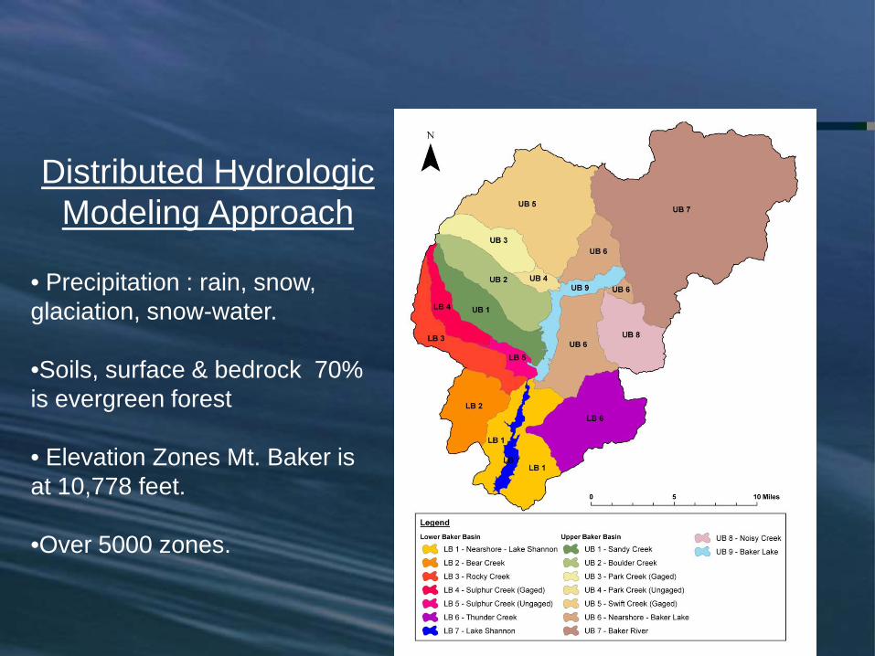
Distributed Hydrologic Modeling Approach
• Precipitation : rain, snow, glaciation, snow-water.
•Soils, surface & bedrock 70% is evergreen forest
• Elevation Zones Mt. Baker is at 10,778 feet.
•Over 5000 zones.

At Mt. Baker, the temperature decreases approximately 3° F with each 1,000 feetincrease in elevation.
Baker Basin

Watershed CharacterizationZones of Mean Annual Precipitation
MGS Engineering

Watershed CharacterizationSoil Zones
MGS Engineering


PMF Deterministic Hydrograph Modeling
Input ParametersSeasonality All months/seasonsStorm Centering Three scenariosStorm Temporal Pattern Three patternsAntecedent Precipitation Average cumulative end of month
value for each monthAntecedent Snow Water Equivalent Iteratively determine return period
resulting in maximum runoff volumeAntecedent Snowpack Density Average end of monthAntecedent UB Reservoir Elevation ACOE flood control rule curve UBKAntecedent LB Reservoir Elevation Normal poolBasin In-Flow Average monthly flowAir Temperature HMR-57 methodologyWind Speed HMR-57 methodology

Model Development
Flow Diagram of Hydrograph Models Used. HEC-5 was used for routing the runoffs through the project.
SPAS HEC-1 SEFM
HFAM
Snowcourse Data
SNOTEL Data
PRISM Mapping
NEXRAD
Runoff Hydrograph
HEC-5

Hydrologic Model Calibration
November 1990 (1) Hydrographs
0
2,000
4,000
6,000
8,000
10,000
12,000
11/08 00:00 11/09 00:00 11/10 00:00 11/11 00:00 11/12 00:00 11/13 00:00 11/14 00:00
Date
Flow
(CFS
)
0.00
0.10
0.20
0.30
0.40
0.50
0.60
0.70
0.80
0.90
1.00
11/08 00:00 11/09 00:00 11/10 00:00 11/11 00:00 11/12 00:00 11/13 00:00 11/14 00:00
Rai
nfal
l (in
)
Model Input Basin Average Precipitation in Low er Baker SubbasinsObserved Total Runoff HydrographSimulated Total Runoff Hydrograph
0
5,000
10,000
15,000
20,000
25,000
30,000
35,000
11/08 00:00 11/09 00:00 11/10 00:00 11/11 00:00 11/12 00:00 11/13 00:00 11/14 00:00
DateFl
ow (C
FS)
0.00
0.10
0.20
0.30
0.40
0.50
0.60
0.70
0.80
0.90
1.00
11/08 00:00 11/09 00:00 11/10 00:00 11/11 00:00 11/12 00:00 11/13 00:00 11/14 00:00
Rai
nfal
l (in
)
Model Input Basin Average Precipitation in Upper Baker SubbasinsSimulated Total Runoff HydrographObserved Total Runoff Hydrograph
Lower Baker Tributary Hydrograph Upper Baker Tributary Hydrograph

Upper Baker PMF HydrographsDeterministic – Pre Global Sensitivity Analysis
700
702
704
706
708
710
712
714
716
718
720
722
724
726
728
730
732
734
736
738
740
742
1/4/2006 0:00 1/5/2006 0:00 1/6/2006 0:00 1/7/2006 0:00 1/8/2006 0:00 1/9/2006 0:00 1/10/2006 0:00 1/11/2006 0:00
Date
Upp
er B
aker
Res
ervo
ir Po
ol (f
eet)
- NA
VD 8
8
0
10,000
20,000
30,000
40,000
50,000
60,000
70,000
80,000
90,000
100,000
110,000
120,000
130,000
140,000
150,000
160,000
170,000
180,000
Flow
Rat
e (c
fs)
Upper Baker Reservoir Elevation
Upper Baker Inflow
Upper Baker Outflow
Max Res. Elev. = 739.84 ft(4.07 feet of overtopping)

Table 8-10. Flood and Reservoir Response Sensitivity to Input Parameters, and Input Parameter Uncertainty
Input Parameter Flood Response
Sensitivity Reservoir Response
Sensitivity Parameter
Uncertainty Seasonality of Occurrence Moderate Moderate Low Centering of Storm Low Low Moderate Storm Temporal Pattern Moderate High Low Antecedent Precipitation Moderate Moderate Low Antecedent Snow Water Equivalent High High Moderate Antecedent Snowpack Density Low Low High Antecedent Reservoir Elevation Lower Baker n/a Low Moderate Antecedent Reservoir Elevation Upper Baker n/a Moderate Moderate
Global Sensitivity AnalysisPer FERC Guidelines.
Table 8-10. Flood and Reservoir Response Sensitivity to Input Parameters, and Input Parameter Uncertainty
Input Parameter Flood Response
Sensitivity Reservoir Response
Sensitivity Parameter
Uncertainty Seasonality of Occurrence Moderate Moderate Low Centering of Storm Low Low Moderate Storm Temporal Pattern Moderate High Low Antecedent Precipitation Moderate Moderate Low Antecedent Snow Water Equivalent High High Moderate Antecedent Snowpack Density Low Low High Antecedent Reservoir Elevation Lower Baker n/a Low Moderate Antecedent Reservoir Elevation Upper Baker n/a Moderate Moderate

PMF Hydrographs - SensitivityGlobal Sensitivity Analysis – Frequency Analysis
728729730731732733734735736737738739740741742
0 10 20 30 40 50 60 70 80 90 100
Percent Non-Exceedance Assuming Full PMP (Based on 10,000 Simulations - All Seasons)
Upp
er B
aker
Res
ervo
ir El
evat
ion
(fee
t N
AVD
88)
Initial PMF Result for Baker Project (739.84 feet ) - 99.4% NE
Final PMF Result for Baker Project (739.19 feet ) - 95.8% NE

PMF Hydrographs - Final
Scenario Peak inflow CFS
Peak outflow CFS
Max Pool Elev. NAVD 88
Depth of overtopping
Upper Baker Reservoir
2 year snow pack
157,800 111,500 739.19 3.42
Lower Baker Reservoir
2 year snow pack
136,800 120,300 458.43 13.86

Stochastic Approach …
1) Use Deterministic Rainfall-Runoff Model (HEC-1)
2) Treat Hydrometeorological Inputs as Variables
3) Stochastically Generate Multi-Thousand Years of Storms and Dates of Storm Occurrence – Use Monte Carlo techniques
4) Select Hydrometeorological Inputs to Accompany Storms and Maintain Seasonal Characteristics and Dependencies Where They Exist
5) Compute Multi-Thousand Flood Annual Maxima using Hydrologic Model and Input Datasets
6) Conduct Frequency Analysis of Model Outputs for: Flood Peak, Runoff Volume, Maximum Reservoir Level

Storm Seasonality
0.000.020.040.060.080.100.120.140.160.180.20
AUG AUG SEP SEP OCT OCT NOV NOV DEC DEC JAN JAN FEB FEB MAR MAR APR APR MAY MAY JUN JUN JUL JUL
MONTH
PRO
BA
BIL
ITY
Smoothed
• Database of 132 extreme storms (rarer than 20-yr event)• Windward Puget Sound Lowlands and West Slope of
Cascades
MGS Engineering
Uses:
• Effectiveness of current flood control rule curveMGS Engineering

Flood Frequency Curves
0
20,000
40,000
60,000
80,000
100,000
120,000
140,000
160,000
ANNUAL EXCEEDANCE PROBABILITY
MA
X 24
-HO
UR
INFL
OW
(cfs
)
Top Historical Peaks from 78Year Period of Record
Extreme Value Type 1 Plotting Paper
10-1010-9.5 10-810-610-510-410-310-210-1
Stochastic Model Results
PMF Estimate107,100 cfs
10-7
Upper Baker Project Frequency Curve
• Stochastic model verified using historical record
• Stochastic results are therefore extension of historical record

Table ES-1. Estimated Annual Exceedance Probabilities Associated with PMF Hydrograph for Upper Baker Dam
Flood Characteristic Magnitude
Annual Exceedance Probability
Peak Inflow 157,800 cfs 5.1 x 10⁻⁹
Maximum 24-Hour Inflow 107,100 cfs 7.2 x 10⁻⁸
Maximum 72-Hour Inflow 59,200 cfs 4.5 x 10⁻⁷
Maximum Reservoir Elevation 739.19 feet a 1.0 x 10⁻⁸
Notes:a.Elevation referenced to North American Vertical Datum of 1988 (NAVD 88)
Table ES-2. Estimated Annual Exceedance Probabilities Associated with PMF Hydrograph for Lower Baker Dam
Flood Characteristic Magnitude
Annual Exceedance Probability
Peak Inflow 136,800 cfs 2.8 x 10⁻⁸
Maximum 24-Hour Inflow 113,200 cfs 5.4 x 10⁻⁸
Maximum 72-Hour Inflow 67,000 cfs 9.5 x 10⁻⁷
Maximum Reservoir Elevation 458.43 feet a 5.3 x 10⁻⁸
Notes:a.Elevation referenced to North American Vertical Datum of 1988 (NAVD 88)
PMF ANNUAL EXCEEDANCE PROBABILITIES

Flood Frequency CurvesUpper Baker Max Elevation
700
705
710
715
720
725
730
735
740
745
750
ANNUAL EXCEEDANCE PROBABILITY
MA
X R
ESER
VOIR
STA
GE
- U
PPER
B
AK
ER (f
t NA
VD88
)
Extreme Value Type 1 Plotting Paper
Stochastic Model Results
10-1010-9.5 10-810-610-510-410-310-210-1
PMF Estimate739.19 ft NAVD88
Top of Dam735.77 ft NAVD88
Top of Flood Control Pool727.77 ft NAVD88
10-7
Upper Baker Project Regulated Frequency Curve

Flood Frequency Curves• Lower Baker Max Elevation
410
415
420
425
430
435
440
445
450
455
460
465
ANNUAL EXCEEDANCE PROBABILITY
MA
X R
ESER
VOIR
STA
GE
- LO
WER
B
AK
ER (f
t NA
VD88
)
Extreme Value Type 1 Plotting Paper
Stochastic Model Results
10-1010-9.5 10-810-610-510-410-310-210-1
PMF Estimate458.43 ft NAVD88
Overtopping Elevation 444.57 ft NAVD88
Normal Full Pool Elevation442.35 ft NAVD88
10-7
Lower Baker Project Regulated Frequency Curve

History of Stochastic Event Flow Model
Development started in 1996 for USBRInitial Public Domain Model Completed in 1998
Used by USBR for Hydrologic Risk Assessments since 1998
Bumping Lake Dam – Bumping River, WA
Cle Elum Dam – Cle Elum River, WA
Keechelus Dam – Yakima River, WA
Minidoka Dam – Snake River, ID
Whiskeytown Dam – Clear Creek, CA
Trinity Dam – Trinity River, CA
A.R. Bowman Dam – Crooked River, OR
MGS Engineering Solutions

History of SEFM …
BChydroMica Dam, Upper Columbia River, BC
Received International Peer Review 2001
US Corps of EngineersFolsom Dam, American River, CA
SEFM Accepted by USCOE for Analysis of Extreme Floods and PMF
Puget Sound EnergyBaker River Project, Baker River, WA
FERC Licensed ProjectMGS Engineering Solutions

Summary
• FERC guidelines require a deterministic solution to define PMF.
• PSE has showed both Lower and Upper Baker Dams are stable under the PMF loading.
• FERC guidelines require that a project must safely pass the PMF. 1:190,000,000 likelihood for PSE.
• What is appropriate FERC AEP?
• What is appropriate PMF approach deterministic vs. stochastic? Or weighted?
• Consider using stochastic criteria as in FERC anticipated Maximum Credible Earthquake likelihood for an Maximum Credible Flood?
• “How often would that there PMF happen?”
• And “is that a reasonable criteria?”