Embed Size (px)
Citation preview
Background Paper: Quarry Restoration, revised April 2012
1
Oxfordshire Minerals and Waste Plan Minerals and Waste Core Strategy
Background Paper revised April 2012
Quarry Restoration
Note: This background paper was largely prepared prior to publication of the government’s National Planning Policy Framework on 27 March 2012 and it has only been partially updated to reflect this new national policy document. 1. Introduction 1.1 This background paper is one of a series which together form part of
the evidence base for the Minerals and Waste Core Strategy. The Core Strategy is part of the Minerals and Waste Plan that will set out a strategy and polices for where minerals should be worked and where waste should be managed in Oxfordshire over the period to 2030. More information about the plan can be found on the Council’s website: www.oxfordshire.gov.uk
1.2 The background papers have been used to identify baseline data and
inform the preparation of policies for inclusion in the Core Strategy. The papers are intended to present evidence as it stands at this stage. They build on work carried out at the previous preferred options stage, incorporating feedback from that consultation and addressing areas that require further discussion. They also provide an opportunity for stakeholders to check the information to ensure the Council’s knowledge and understanding is up to date and robust.
1.3 The background papers are ‘living draft’ documents and may continue
to be revised throughout the process of preparing the Core Strategy. 1.4 Mineral workings are considered a temporary land use; the land should
ultimately be restored to a positive land-use when extraction has been completed. Government planning policy recognises this in Planning Policy Guidance Notes and Minerals Planning Guidance Notes and Statements, notably in PPG 21, which states:
‘Minerals can be worked only where they are found. Their extraction is a temporary activity.’
1.5 The restoration of a site should be determined in relation to its land-use
context and surrounding environmental character. As part of the process of seeking planning permission for mineral extraction, the applicant must demonstrate that they will restore the site after quarrying to an appropriate land use and the restoration plan should be approved as part of the planning permission.
1 CLG (2001) Planning Policy Guidance 2: Green Belts
Background Paper: Quarry Restoration, revised April 2012
2
1.6 Progressive restoration of phases of working is strongly favoured as
this normally reduces the overall environmental impact of mineral extraction.
1.7 The County Council is responsible for formulating policy to guide
mineral extraction and restoration & district councils are responsible for determining applications for development in former areas of mineral extraction. The County and District Councils therefore need to work together to ensure policies in Local Development Frameworks and in the Minerals and Waste Development Framework are compatible.
1.8 This paper is part of the evidence base for the County Council’s
Minerals and Waste Core Strategy proposed submission document, which includes policy M7 on the restoration of mineral workings.
2. Executive Summary 2.1 Section 3 defines mineral restoration and describes different land uses
to which minerals sites are often restored. Examples of these in Oxfordshire are given.
2.2 Section 4 reviews national and regional planning policy on minerals
restoration and identifies policies in MPS 1, MPG7, PPS 9 and the South East Plan which encourage restoration of minerals sites as an opportunity to increase biodiversity and access to the countryside. It also includes relevant policy in the National Planning Policy framework, which replaced MPS 1, MPG 7 and PPS 9 in March 2012.
2.3 There are several active airfields in Oxfordshire. Section 5 explains
how birds can pose a danger to aircraft, and how some forms of quarry restoration, such as the restoration to open water, can attract birds and increase the risk of bird strike. Consultation should take place with the relevant aviation authorities from the pre-application stage to ensure that any necessary mitigation measures are incorporated in the proposed operation of the site and restoration scheme to minimise the potential for bird strike.
2.4 Section 6 discusses the availability of inert fill for use in restoration of
minerals sites. 2.5 Section 7 describes how funding by developers of the restoration and
management of quarries for nature conservation uses can be secured, including through the use of section106 agreements.
2.6 Section 8 identifies a number of issues which need to be considered in
the planning of restoration of quarries in Oxfordshire. 2.7 Section 9 identifies policy approaches considered by the Council.
Background Paper: Quarry Restoration, revised April 2012
3
3. Restoration 3.1 Restoration can be defined as any operations associated with the
winning and working of minerals that are designed to return the land to an acceptable landform and after-use. MPG 72 notes that this may be for the resumption of a former land use or for a new use.
3.2 Restoration of mineral working can be for a number of purposes. The
types of restoration listed here are not mutually exclusive and the list is not exhaustive. Where possible, restoration should have a primary end-use but all schemes have the potential to enhance biodiversity and the landscape and improve public access. Potential purposes of restoration are:
To enhance nature conservation and/or landscape character; To restore or improve agricultural land quality; To facilitate leisure and recreational development; To create/link rights of way; For use for flood alleviation and water supply; To create benefits for local communities.
3.3 Nature conservation and/or landscape character 3.3.1 Quarry restoration can provide an opportunity to create habitats for
wildlife and for nature conservation. 'Nature conservation after-use' is defined as restoration which meets Biodiversity Action Plan aims delivered through the Conservation Target Areas approach and/or conserves and enhances other priority species and habitats and is managed primarily for the benefit of biodiversity for a long-term (e.g. 25 year) aftercare and management period. Such restored sites may also include public access and amenity, provided that this does not prevent the nature conservation objectives being met.
3.3.2 The UK’s Biodiversity Action Plan targets form the Government’s
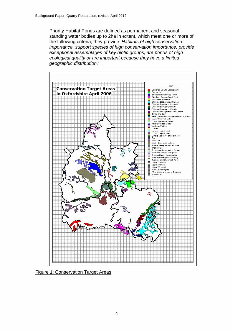
commitment to biodiversity. Local implementation of these targets is through the Oxfordshire Biodiversity Action Plan (BAP), which uses the Conservation Target Area (CTA) approach to deliver its targets. There are 20 UK BAP priority habitats in Oxfordshire and 36 CTAs in the county; each CTA supports one or more of the BAP priority habitats. The CTAs cover 17% of the land area of Oxfordshire and they identify where targeted conservation work will have the greatest benefit3. The Conservation Target Areas are shown below in Figure 1.
3.3.3 The Conservation Target Areas approach did not include ponds as a
target habitat because they were not priority habitat at the time. However, UK BAP priority ponds can be created on any restored minerals site, not just those restored for nature conservation. UK BAP
2 The then ODPM (1996) Minerals Planning Guidance 7: Reclamation of mineral workings 3 http://www.oncf.org.uk/biodiversity/cta.html
Background Paper: Quarry Restoration, revised April 2012
4
Priority Habitat Ponds are defined as permanent and seasonal standing water bodies up to 2ha in extent, which meet one or more of the following criteria; they provide ‘Habitats of high conservation importance, support species of high conservation importance, provide exceptional assemblages of key biotic groups, are ponds of high ecological quality or are important because they have a limited geographic distribution.’
Figure 1: Conservation Target Areas
Background Paper: Quarry Restoration, revised April 2012
5
3.3.4 Much of the sand and gravel resource in Oxfordshire is located along the Thames, Lower Evenlode and Lower Windrush river valleys, where CTAs have been identified. This presents an opportunity for sand and gravel quarry restoration to contribute to linking and developing the habitats in these conservation target areas although adverse effects upon existing features of ecological interest may also result. Effects may include the modification of surface flows to watercourses or existing ponds, and alteration of groundwater seepages, flushes or spring flows.
3.3.5 Biodiversity Action Plan targets associated with the Upper Thames and
Lower Windrush Valley river corridors4 are: Lowland Meadows – one of the key habitats in this area; Wet grassland; Floodplain Grazing Marsh; Mesotrophic / Eutrophic Standing Water – large numbers of
water filled gravel pits managed largely for fishing and water sports; all the lakes collectively support a rich invertebrate fauna and aquatic plant flora;
Reedbed (and swamp) – management and creation. 3.3.6 Soft sand is extracted south west of Oxford in a number of quarries
between Oxford and Faringdon. Soft sand quarries are not as extensive as sand and gravel quarries but they still offer opportunities to enhance or link CTAs.
3.3.7 The West Oxfordshire Heights CTA is found in the vicinity of some soft
sand quarries south of Faringdon. Biodiversity Action Plan Targets associated with the West Oxfordshire Heights CTA are:
1. Wet woodland – management; 2. Fen – management; 3. Lowland dry acid grassland – management and restoration; 4. Lowland mixed deciduous woodland – management; 5. Parkland (including veteran trees) – management and
restoration. 3.3.8 The Oxford Heights West CTA encompasses the area west of Oxford
around the soft sand quarries at Tubney and Upwood Park. The Biodiversity Action Plan Targets associated with the Oxford Heights West CTA are:
1. Lowland heathland and lowland dry acid grassland – management and restoration (on the sandstone);
2. Fen – management and restoration; 3. Lowland mixed deciduous woodland – management and
restoration; 4. Lowland meadows – management and restoration (mainly on
the northern escarpment); 5. Lowland calcareous grassland – management and creation;
4 http://www.oncf.org.uk/biodiversity/cta.html
Background Paper: Quarry Restoration, revised April 2012
6
6. Arable field margins – management and creation (particularly for arable wildflowers).
3.3.9 Because soft sand is normally worked ‘dry’, ie above the water table,
there is opportunity for restoration to be to dry land and to incorporate some of the target habitats listed above, although this may be dependent on the availability of inert fill to raise ground levels; this is discussed in section 6 of this paper.
3.3.10 The RSPB and Natural England’s ‘Nature after Minerals’ programme is
based on a vision for restoration of minerals sites to contribute to large scale habitat creation and to augment, maintain and link BAP habitats. The programme recognises that two conditions are key to delivering large scale habitat creation:
Securing funding for long-term management will unlock many more opportunities by making nature conservation a more attractive option to landowners; guidance must be provided to facilitate this through local planning policies (including for minerals);
Planning policies and site allocations should support habitat creation on mineral sites.
3.3.11 The issue of funding is discussed in section 6. Policies can be included
in the Core Strategy to support and encourage habitat creation to enhance, link and increase habitats for wildlife.
3.4 Geodiversity 3.4.1 After-use of mineral extraction sites provides an opportunity to enhance
study and public understanding of Oxfordshire geodiversity. 3.4.2 Oxfordshire’s bedrock ranges from the Lower Jurassic to the Upper
Cretaceous a covering a time span from about 200-90 million years ago. Since then there has been uplift and erosion before the sands and gravels of the Quaternary, present mainly in the river valleys, were deposited. In common with most inland counties there is little in the way of natural outcrop meaning that current and disused quarries, along with road cuttings, and other excavations are essential in gaining an understanding of the sequence of the geological strata.
3.4.3 A Local Geodiversity Action Plan (LGAP), which outlines the
importance of the Lower and Middle Jurassic of the county was produced by Oxfordshire Geology Trust in 2006. At present there is not a countywide LGAP but this would be beneficial in order to draw together the importance of the geodiversity of the county and links to extraction, restoration and biodiversity.
3.4.4 There are 44 Local Geological Sites (formerly know as Regionally
Important Geological Sites – RIGS) in the county and these are designated by Oxfordshire Geology Trust using criteria established by
Background Paper: Quarry Restoration, revised April 2012
7
GeoconservationUK to meet any of four criteria including scientific and educational purposes. Of these 44 sites the majority of them, 34, are in current or disused quarries. Some of these sites, and others, are also of national significance and are designated as SSSIs, including Shipton on Cherwell, Ardley, Chinnor and Kirtlington. In total there are 23 SSSIs designated for geological interest in the county and the majority of these are disused quarries. Ardley Quarry has both national and worldwide significance for the dinosaur footprints found there and the first description of a dinosaur, Megalosaurus, was from the Stonesfield Slate Mines.
3.4.5 Many sites have both geodiversity and biodiversity interest, for
example Dry Sandford Pit, which includes a fen at the base and offers a good opportunity for hymenoptera in the soft sand faces. Contributions to nature conservation can be achieved by integrating geodiversity with biodiversity initiatives particularly in restoration designs5.
3.4.6 It is important to work with all parties concerned with mineral extraction,
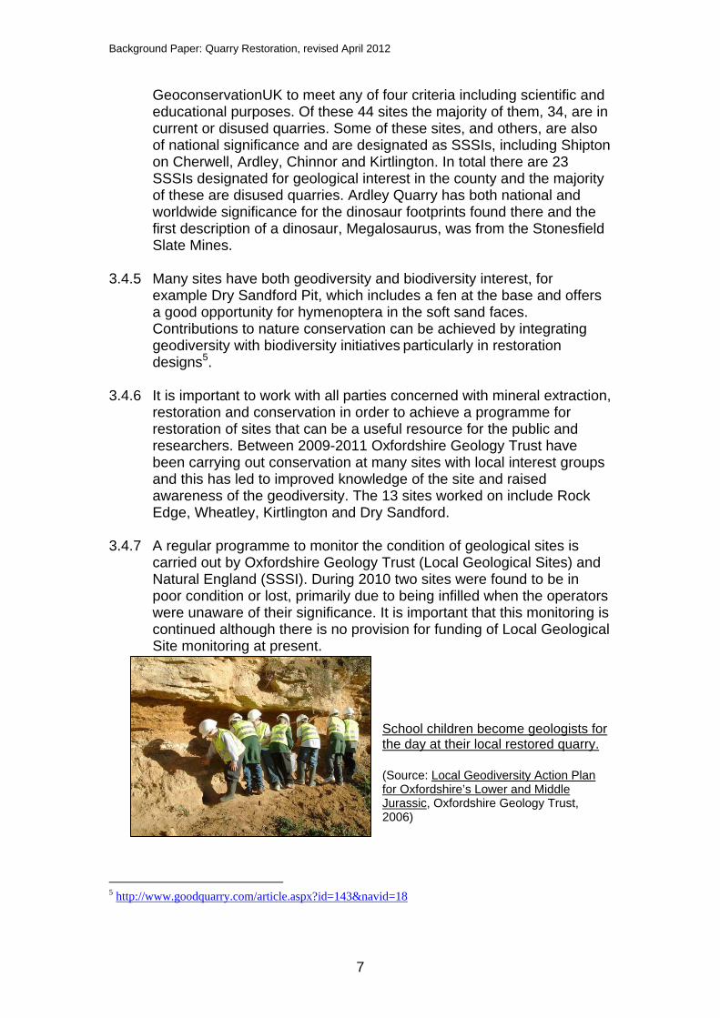
restoration and conservation in order to achieve a programme for restoration of sites that can be a useful resource for the public and researchers. Between 2009-2011 Oxfordshire Geology Trust have been carrying out conservation at many sites with local interest groups and this has led to improved knowledge of the site and raised awareness of the geodiversity. The 13 sites worked on include Rock Edge, Wheatley, Kirtlington and Dry Sandford.
3.4.7 A regular programme to monitor the condition of geological sites is
carried out by Oxfordshire Geology Trust (Local Geological Sites) and Natural England (SSSI). During 2010 two sites were found to be in poor condition or lost, primarily due to being infilled when the operators were unaware of their significance. It is important that this monitoring is continued although there is no provision for funding of Local Geological Site monitoring at present.
School children become geologists for the day at their local restored quarry. (Source: Local Geodiversity Action Plan for Oxfordshire’s Lower and Middle Jurassic, Oxfordshire Geology Trust, 2006)
5 http://www.goodquarry.com/article.aspx?id=143&navid=18
Background Paper: Quarry Restoration, revised April 2012
8
3.5 Landscape 3.5.1 Oxfordshire contains parts of three Areas of Outstanding Natural
Beauty; the Cotswolds, the Chilterns and the North Wessex Downs. The council seeks to further the conservation and enhancement of the natural beauty of the AONBs. Government policy is that major mineral developments should only be permitted in AONB in exceptional circumstances. There are sufficient aggregate resources in Oxfordshire outside the AONB such that working within these areas is not necessary. However, small scale extraction of building stone for local use, or small scale waste facilities with an annual throughput of less than 20,000tpa may be appropriate in the AONBs.
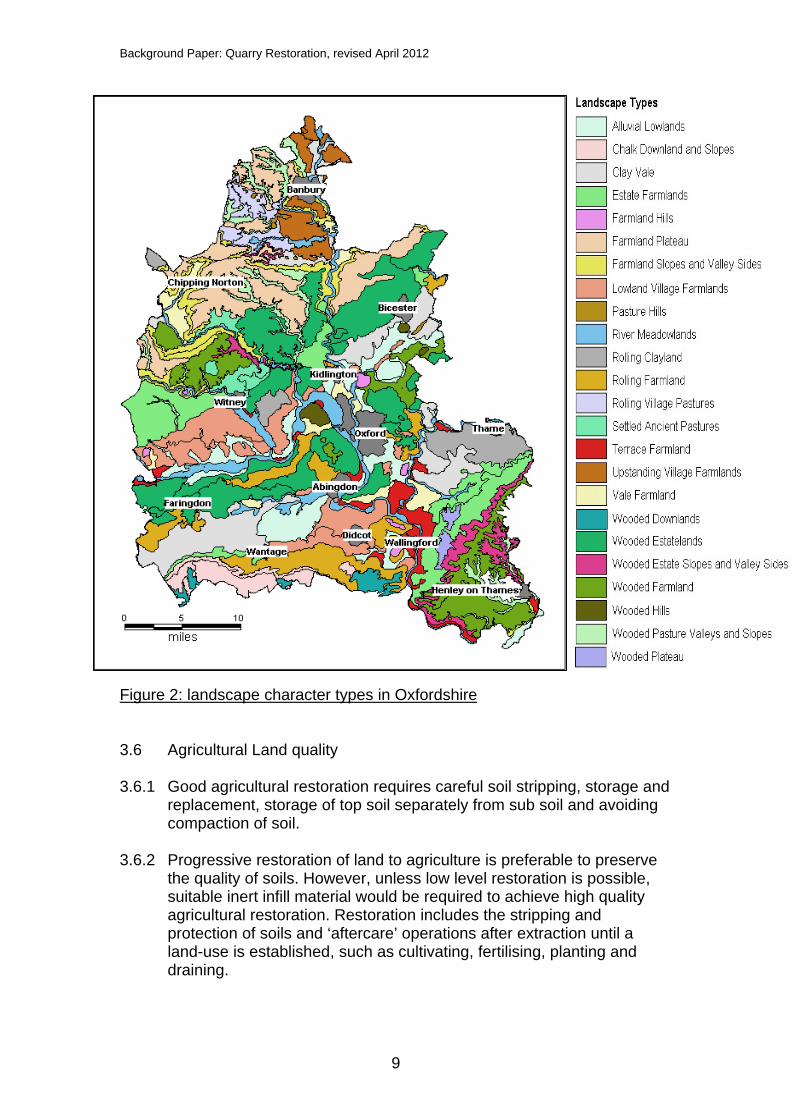
3.5.2 The Oxfordshire Wildlife and Landscape study was carried out by
Oxfordshire County Council, English Nature, the Northmoor Trust and the Countryside Agency and was completed in 2004. The study sought to improve information about the biodiversity and landscape character areas of Oxfordshire. It identified 24 landscape types in the county; figure 2 shows the 24 landscape character types in Oxfordshire. Further information on the characteristics of each of the landscape types can be found at:
http://owls.oxfordshire.gov.uk/wps/wcm/connect/occ/OWLS/Home/Oxfordshire+Landscape+Types/
3.5.3 The restoration of a site should be determined in relation to its land-use
context and surrounding environmental character. The character of the local landscape should therefore be one of the criteria taken into account when the restoration of a quarry is planned. Locally characteristic species should be used for planting schemes.
Background Paper: Quarry Restoration, revised April 2012
9
Figure 2: landscape character types in Oxfordshire 3.6 Agricultural Land quality 3.6.1 Good agricultural restoration requires careful soil stripping, storage and
replacement, storage of top soil separately from sub soil and avoiding compaction of soil.
3.6.2 Progressive restoration of land to agriculture is preferable to preserve
the quality of soils. However, unless low level restoration is possible, suitable inert infill material would be required to achieve high quality agricultural restoration. Restoration includes the stripping and protection of soils and ‘aftercare’ operations after extraction until a land-use is established, such as cultivating, fertilising, planting and draining.
Background Paper: Quarry Restoration, revised April 2012
10
3.6.3 Agricultural land can be restored to an amenity or nature conservation afteruse such as species rich grassland, but where ‘best and most versatile’ land is involved the methods used in the restoration and aftercare should aim to preserve the long term agricultural potential of the land for the future. All site restoration should seek some biodiversity enhancement, even if biodiversity is not the prime after use.
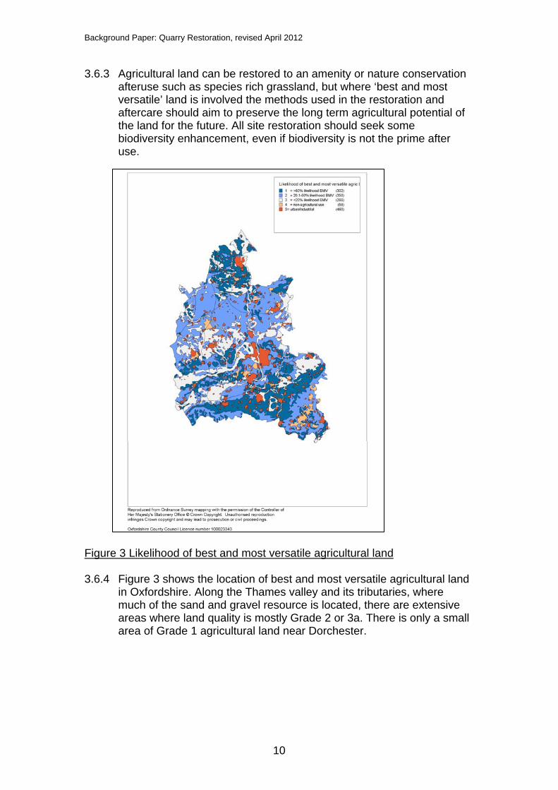
Figure 3 Likelihood of best and most versatile agricultural land 3.6.4 Figure 3 shows the location of best and most versatile agricultural land
in Oxfordshire. Along the Thames valley and its tributaries, where much of the sand and gravel resource is located, there are extensive areas where land quality is mostly Grade 2 or 3a. There is only a small area of Grade 1 agricultural land near Dorchester.

Background Paper: Quarry Restoration, revised April 2012
11
3.7 Leisure and recreational development and rights of way 3.7.1 Minerals operations and subsequent restoration offers opportunities to
provide short and long term community benefits which can include improving public access to specific landscape, archaeological sites or attractions, improving existing or creating new public rights of way for walkers, cyclists and horseriders, including those with disabilities, providing open water for sailing, canoeing or fishing as well as providing access to nature conservation areas. Community benefits can be realised during the operational phases of quarrying, such as creating view points of the workings with interpretation boards explaining, for example, the geology of the area and what mineral is being extracted, the biodiversity using the active site and what the mineral will be used for.
3.7.2 If planned and managed well, a scheme to manage access in the
construction and operational phases as well as a restoration scheme can incorporate leisure and access as well as conservation work and habitat creation. Improvements to rights of way could enable biodiversity improvements to be linked with other planned green space improvements such as providing green corridors for wildlife movement or for walking, cycling or horseriding. The management regime of site after uses may influence the types of land use, access to land and the level of possible social, community and economic benefits.
3.7.3 The majority of sand and gravel extraction sites in Oxfordshire that
have been permitted to date have resulted in the creation of lakes used for leisure activities such as fishing, sailing and other watersports. These lakes are mainly in private ownership, managed as members clubs or commercial businesses.
3.7.4 In the Lower Windrush Valley, the development of a coordinated after
use strategy has enabled a greater emphasis on securing general public access to restored sites and the wider countryside. A specific policy in the existing Local Plan makes provision for the establishment and long term management of the Windrush Path, a footpath from Witney to the River Thames at Newbridge with associated circular routes and areas of public access. 8km of new footpaths, 10ha of public open space and the creation of two new nature reserves with disabled access have been opened to the public to date through planning agreements in the Lower Windrush.
3.7.5 Plans for restoration which will create new leisure or amenity facilities
need to take into account long term impacts, including traffic generation, associated with any proposed development and balance these with potential positive impacts such as employment generation, boosts to the economy and providing more opportunities for walking, cycling and riding.
Background Paper: Quarry Restoration, revised April 2012
12
3.8 Flood alleviation and water supply 3.8.1 Extraction of minerals from sites in the floodplain can afford the
opportunity to use the void created to store water, either on a permanent basis or for temporary use when neighbouring watercourses flood or groundwater levels rise. There are no examples of former quarries being used for flood alleviation to date in Oxfordshire.
4. Planning Policy on mineral restoration 4.1 National Policy 4.1.1 MPG 76 sets out the contribution which reclaimed mineral sites can
make to the Government’s policies for sustainable development and mineral working, and for land use and other policies in the wider countryside. Paragraph 2 notes that:
‘restoration and aftercare should provide the means to maintain or, in some circumstances, even enhance the long-term quality of land and landscapes taken for mineral extraction’.
4.1.2 Paragraph 13 of MPG7 also notes that most land taken for mineral
working is in agricultural use prior to extraction and that; ‘where minerals underlie the best and most versatile agricultural land it is particularly important that restoration and aftercare preserve the long-term potential of the land as a national, high quality, agricultural resource.’
4.1.3 Paragraph 19 of MPG 7 recognises the contribution mineral restoration
can make to increasing amenity uses: ‘Mineral workings reclaimed to amenity use can… contribute to Government policies in respect of recreation and nature conservation, including making a contribution to the UK Biodiversity Action Plan.’
4.1.4 MPS1 sets out the Government’s key overarching policies and
principles which apply to all minerals. An objective of MPS 1 is: ‘to protect and seek to enhance the overall quality of the environment once extraction has ceased, through high standards of restoration, and to safeguard the long term potential of land for a wide range of after uses’.
4.1.5 MPS 1 also notes that local planning authorities should have regard to
the positive or negative effects that minerals operations may have on rural communities and the extent to which adverse impacts of such operations could be moderated, but recognise that such developments
6 Mineral Planning Guidance: The Reclamation of Mineral Workings ODPM, 1996)
Background Paper: Quarry Restoration, revised April 2012
13
can often also offer opportunities for these communities, especially at the restoration stage.
4.1.6 PPS 97 encourages mineral restoration to contribute towards an
increase in biodiversity and habitat creation: ‘LDFs should identify any new areas or sites for the restoration or creation of new priority habitats which contribute to regional targets, and support this restoration or creation through appropriate policies.’
4.1.7 The government’s National Planning Policy Framework (NPPF) was
published on 27 March 2012 and has replaced MPS 1, MPG 7 and PPS 9 with immediate effect. The NPPF states that local planning authorities should ‘put in place policies to ensure worked land is reclaimed at the earliest opportunity, taking account of aviation safety, and that high quality restoration and aftercare of mineral sites takes place, including for agriculture (safeguarding the long term potential of best and most versatile agricultural land and conserving soil resources), geodiversity, biodiversity, native woodland, the historic environment and recreation’.
4.1.8 The government’s Technical Guidance to the National Planning Policy
Framework, published alongside the NPPF, provides further guidance. It notes that reclamation schemes should set out how the restoration and after care of the site is to be integrated with the working scheme and that ‘progressive’ or phased reclamation is preferable, to minimise the area of land occupied at any one time by mineral working.
4.1.9 The NPPF does not refer specifically to the potential of minerals
restoration to contribute to Biodiversity Action Plan targets although paragraph 109 of the NPPF does note that the planning system should ‘contribute to and enhance the natural and local environment by minimising impacts on biodiversity and providing net gains in biodiversity where possible, contributing to the Government’s commitment to halt the overall decline in biodiversity, including by establishing coherent ecological networks that are more resilient to current and future pressures’
4.2 Regional policy 4.2.1 The Regional Spatial Strategy, the South East Plan8, adopted in May
2009 is part of the statutory development plan for Oxfordshire. The Coalition Government has stated its intention to revoke all regional strategies, and this is provided for in the Localism Act 2011.
7 CLG (2005) Planning Policy Statement 9: Biodiversity & Geological Conservation 8 Government Office for the South East (2009) The South East Plan: Regional Spatial Strategy for the South East of England
Background Paper: Quarry Restoration, revised April 2012
14
4.2.2 Policy NRM 5 of the South East Plan states that: ‘Local planning authorities and other bodies shall avoid a net loss of biodiversity, and actively pursue opportunities to achieve a net gain across the region. They shall influence and applying agri-environment schemes, forestry, flood defence, restoration of mineral extraction sites and other land management practices to:
Deliver biodiversity targets; Increase the wildlife value of land; Reduce diffuse pollution; and Protect soil resources.’
4.2.3 Policy C4: Landscape and Countryside Management of the South East
Plan states that ‘outside nationally designated landscapes, positive & high quality management of the region’s open countryside will be encouraged and supported by local authorities and other organisations, agencies, land managers, the private sector, grant aid and other measures.’
4.2.4 Policy C6 of the South East Plan (Countryside Access and Rights of
Way Management) states that: ‘Through Rights of Way Improvement Plans and other measures, local authorities should encourage access to the countryside, taking full advantage of the Countryside and Rights of Way Act 2000, particularly by maintaining, enhancing and promoting the Public Rights of Way system, and permissive and longer distance routes, to facilitate access within, to and from the countryside for visitors and all members of the local community.’
4.2.5 Policy C7 of the South East Plan (River Thames Corridor) states that:
‘taking account of the Thames River Basin Management Plan, local authorities should work together with other agencies to:
Maintain and enhance the landscapes and waterscapes of the River Thames Corridor, in terms of their scenic and conservation value and their overall amenity;
Conserve and enhance the nature conservation resources of the River Thames Corridor though the protection and management of its diverse plant and animal species, habitats (including wildlife networks) and geological features;
Provide accessible facilities and opportunities for countryside and river-related recreation;
Take account of the setting of the river in exercising their normal development control duties.
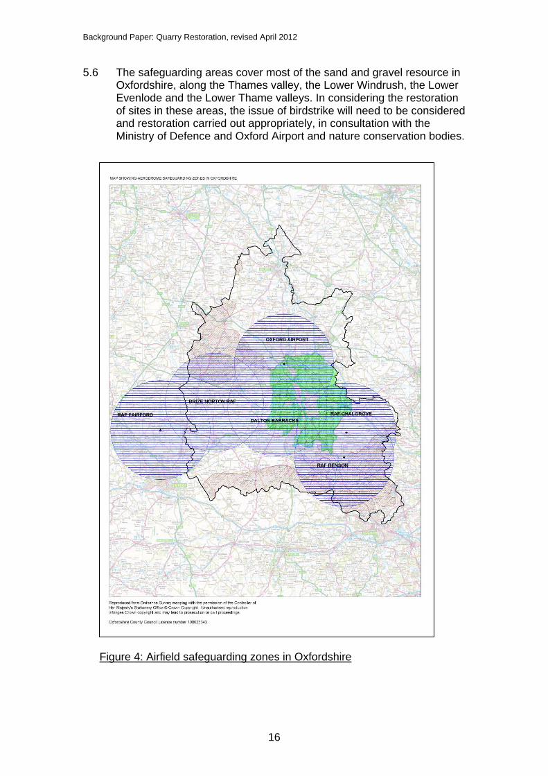
5. Airfield safeguarding 5.1 Airfield safeguarding zones are zones in which local planning
authorities are required to consult either the military authorities or local civilian airports before granting planning permission for any development which is likely to attract birds within a 13km radius of an
Background Paper: Quarry Restoration, revised April 2012
15
officially safeguarded civil aerodrome or within 8 miles of an officially safeguarded military aerodrome9.
5.2 Para 19 of MPS 1 notes that planning authorities should consult the
owner or operator of civil and military aerodromes within 13km, in order to assess the likelihood of increasing the bird strike hazard where restoration of mineral workings is through landfill or to a wetland habitat.
5.3 Measures can be taken to reduce the risk of birdstrike to aviation. Birds
have caused catastrophic accidents to all types of aircraft. The issue of birdstrike is particularly relevant to mineral working where quarries within the given distances to airfields are proposed to be restored to open water. In Oxfordshire, much of the sand and gravel resource lies in the valley of the River Thames and its tributaries, where the water table is high. Once gravel is extracted, the remaining void naturally fills with water. Open water can attract flocks of birds such as waterfowl and gulls which pose a particular threat to aircraft safety.
5.4 Airfield safeguarding does not prevent mineral working taking place,
but, in discussion with the relevant aviation authorities, restoration should be planned at the planning application stage to minimise the risk of bird strike from the site during operation as well as in afteruse. Where wetland restoration is planned, in order to avoid creating open stretches of water, reedbeds may be planted and inert fill used to create islands and to reduce the depth of the water.
5.5 Table 1 lists the aerodromes in Oxfordshire or close to the county
boundary which are safeguarded and figure 4 shows the safeguarding zones around these sites.
Table 1 Safeguarded aerodromes in Oxfordshire
9 DfT (2003) Circular 1/2003: Safeguarding, Aerodromes, Technical Sites and Military Explosives Storage Areas, Annex 2.
Safeguarded aerodromes
Military Civil
RAF Brize Norton Dalton Barracks RAF Chalgrove RAF Benson RAF Fairford
Oxford Airport
Background Paper: Quarry Restoration, revised April 2012
16
5.6 The safeguarding areas cover most of the sand and gravel resource in Oxfordshire, along the Thames valley, the Lower Windrush, the Lower Evenlode and the Lower Thame valleys. In considering the restoration of sites in these areas, the issue of birdstrike will need to be considered and restoration carried out appropriately, in consultation with the Ministry of Defence and Oxford Airport and nature conservation bodies.
Figure 4: Airfield safeguarding zones in Oxfordshire
Background Paper: Quarry Restoration, revised April 2012
17
6. Inert fill 6.1 In seeking to obtain planning permission for mineral extraction where
the proposed restoration requires infill with inert waste, the applicant should demonstrate that there will be sufficient waste material available toe enable this. In recent years, the amount of inert waste available to fill quarry voids has reduced as the proportion of the waste that is recycled has increased, in line with increasing European, national and regional targets for recovery of resources (aggregates and soils) and diversion of inert waste from landfill. The use of waste for restoration is also subject to separate regulation by the Environment Agency.
6.2 Inert fill may be used to restore sites to their original levels or as
landscaping materials in the creation of recreation or nature conservation after uses. Inert wastes have been used widely in the restoration of sand and gravel workings, especially those which are located in areas with a high water table10; in Oxfordshire many of these are located along the River Thames or its tributaries. Within the functional floodplain, it is considered that restoration of sand and gravel sites is part of that working and therefore is defined as water compatible development.
7. Funding for restoration for nature conservation 7.1 Mineral companies and landowners involved in mineral working often
have considerable land holdings (freehold or leasehold) over which they have control or influence. This includes currently operational sites, restored areas, proposed future extraction areas and land which will never be worked. An integrated approach to management of these areas can provide for an optimum site after-use strategy11.
7.2 In 1991, Oxfordshire County Council set up a scheme to fund post
mineral restoration for nature conservation purposes. Developers are currently asked to fund the management of the restored site for a minimum of 20 years, following the statutory 5 year after-care period. Contributions are calculated based on the estimated costs of managing the habitats on the site for a 20 year period. The calculations include the cost of an estate worker and equipment to carry out most work, plus specialist contractors where required eg for reed bed management. This funding arrangement is discussed at pre-application meetings and has been successfully implemented at quarries within the Lower Windrush Valley.
7.3 There are a number of options for the management of a restored site; it
may be managed by the landowner or the developer, or by a national or local wildlife organisation. The provision of bonds or insurance
10 Quarry Products Association (2006) The need for inert wastes to restore aggregate mineral workings 11 http://www.quarry-restoration.com/landscape.htm
Background Paper: Quarry Restoration, revised April 2012
18
policies may also be a suitable mechanism to secure guaranteed funds. Whoever does manage the site for the 20 year period is reimbursed annually from the fund held by OCC, when the monitoring officers are satisfied that the site is being managed appropriately.
7.4 After a 20 year period, any money left in the fund is used by the County
Council in discussion with the landowner or operator on related projects.
8. Issues for consideration: 8.1 Restoration of minerals sites in Oxfordshire can and should contribute
to enhancing and linking Conservation Target Areas, creating BAP habitats for wildlife.
8.2 Restoration of minerals sites in Oxfordshire will need to take account of
the requirement to consult and work with the MOD and Oxford Airport to ensure that restoration is carried out in such a way so as not to increase the likelihood of bird strike.
8.3 The availability of inert fill for restoration is limited and decreasing,
which may constrain the types of restoration possible. Phased extraction and restoration of mineral workings enables maximum availability of fill. Use of inert fill in mineral restoration should be prioritised particularly for quarries with nature conservation after uses where ground levels are critical to the delivery of certain BAP priority habitats.
8.4 The current funding mechanism for nature conservation in the Lower
Windrush Valley should be continued and could be extended to cover other strategic mineral extraction areas.
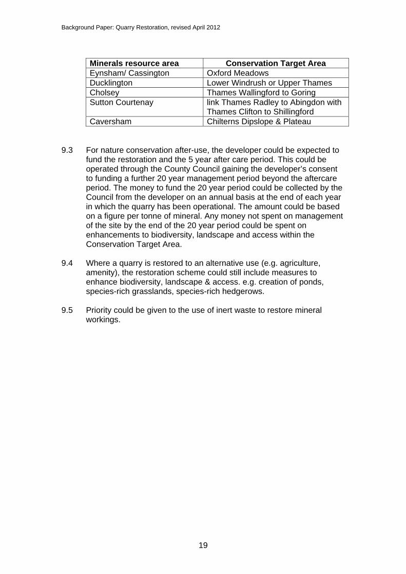
9. Possible policy approaches considered 9.1 Minerals and waste developments could, where possible, contribute
towards Oxfordshire's Biodiversity Action Plan (BAP), which is delivered through the Conservation Target Areas (CTA) approach. Developments could contribute towards meeting the targets of the closest CTA. This could be through any of all of the following: a landscape scheme, a restoration scheme or contributions for off-site works within the CTA.
9.2 The table below shows which CTAs relate to each of the minerals
resource areas within the preferred minerals strategy; individual site restoration schemes should contribute towards meeting the targets of these CTAs.
Background Paper: Quarry Restoration, revised April 2012
19
Minerals resource area Conservation Target Area Eynsham/ Cassington Oxford Meadows Ducklington Lower Windrush or Upper Thames Cholsey Thames Wallingford to Goring Sutton Courtenay link Thames Radley to Abingdon with
Thames Clifton to Shillingford Caversham Chilterns Dipslope & Plateau
9.3 For nature conservation after-use, the developer could be expected to
fund the restoration and the 5 year after care period. This could be operated through the County Council gaining the developer’s consent to funding a further 20 year management period beyond the aftercare period. The money to fund the 20 year period could be collected by the Council from the developer on an annual basis at the end of each year in which the quarry has been operational. The amount could be based on a figure per tonne of mineral. Any money not spent on management of the site by the end of the 20 year period could be spent on enhancements to biodiversity, landscape and access within the Conservation Target Area.
9.4 Where a quarry is restored to an alternative use (e.g. agriculture,
amenity), the restoration scheme could still include measures to enhance biodiversity, landscape & access. e.g. creation of ponds, species-rich grasslands, species-rich hedgerows.
9.5 Priority could be given to the use of inert waste to restore mineral
workings.