Embed Size (px)
Citation preview
B. C. TAP WATER ALLIANCE
Caring for, Monitoring, and Protecting
British Columbia’s Community Water Supply Sources
Email – [email protected]
Websites – www.bctwa.org & www.bctwa.org/FrackingBC.html
April 16, 2016 Bulletin # 01
BC Ministry of Environment Cover-Up Continues
in Posted “Community Watershed History”
Vancouver: BC Environment Minister Mary Polak’s Ministry continues to publish misleading
information on its website concerning the history of BC’s Community Drinking Watersheds.
1. The Ministry references the origins of an October 1980 document, Guidelines for Watershed
Management of Crown Lands used as Community Water Supplies, and mentions the existence of
“285 community watersheds.” But, as with its Social Credit predecessor, the BC Liberal’s Ministry
of Environment also fails, intentionally, to divulge the legal status of the “watersheds,” when, in
fact, they were all approved Community Watershed Reserve tenures established by Cabinet under
the Land Act. (See attached Backgrounder for information.)
The 1980 list of 285 Community Watershed Reserves was authorized for establishment by the New
Democratic Party administration in 1973, by way of powerful enabling legislation and the creation
of the Environmental and Land Use Technical Committee, which reported directly to Cabinet. The
Committee appointed a Provincial Task Force on Community Watersheds (February 1972 to
October 1980). Described in Appendix A of The Big Eddy, these Crown Land Map and Order-in-
Council Reserves are legal land planning instruments defined under the 1970 Land Act and Land
Act planning policies, whereby reserved Crown lands are intended to be fully protected from all
Crown permitted uses, “… withdrawn from disposition under this or any other Act.”
2. The Environment Ministry’s selective history makes reference to a 1992 multi-agency Technical
Advisory Committee, which was convened by the New Democratic government of the day. It was
mandated to “update the original list of community watersheds compiled in 1977,” in order to
“develop new guidelines for protecting drinking water.” The Committee omitted to inform British
Columbians of the existence of BC’s Community Watershed Reserves and their legal purpose to
protect the public’s drinking water sources and instead completely ignored them.
3. Government’s unmitigated and unrelenting resolve to deceive the public, by withholding the real
history of Community Watershed Reserves, is compounded in the website’s final history segment.
The Environment Ministry ends by incorrectly summarizing that “community watersheds” –
carefully avoiding naming or mentioning “Reserves” – thereby became subject to the authority of
the former Forest Practices Code Act and, later subject to its successor the Forest and Range
Practices Act of 2004.
As narrated by the Alliance in From Wisdom to Tyranny: A History of BC’s Community Watershed
Reserves, and in its sequel The Big Eddy report, the BC government, through the appointed powers
of Land Use Planning administrators, such as the Commission on Resources and Environment
(CORE) and the Land Use Coordinating Office (LUCO), illegally withheld the tenure statuses of
BC’s Community Watershed Reserves from all legal Land Use Planning table processes during the
1990s and 2000s. These were the Regional, Sub-Regional and Local Land Use Plans, whereby
Community Watershed Reserves were illegally reassigned for timber supply by timber supply
analysts during the new provincial Timber Supply Review processes. In 1995, government
unscrupulously attempted to subsume the Teflon-coated Community Watershed Reserves under the
Forest Practices Code (FPC) Act, but in fact the Act exempted those “community watersheds” that
had been reserved under the Land Act, prior to the existence of the FPC.
Prior to enacting Provincial Land Use Plans, in 1984 the Social Credit government began to conduct
numerous Integrated Watershed Management Plan (IWMP) processes with affected water
purveyors where government’s official “turning a blind eye” policy (Sympathetic Administration)
was beginning to seriously compromise water quality, while BC’s Chief Foresters reassigned
Community Watershed Reserve Crown land tenures to the Timber Harvesting Land Base and the
Annual Allowable Cut calculation.
The Alliance’s publication, From Wisdom to Tyranny, was entered as evidence in Vancouver
Supreme Court proceedings concerning Western Forest Products’ logging in the Sunshine Coast’s
Chapman Creek Watershed Reserve in 2008. The Reserve is the main source of water supply for the
Sunshine Coast Regional District. Shortly after the Court proceedings, the Government began to
secretly demote over sixty Community Watershed Reserves in southwest BC, including Chapman
Creek, without so much as advising affected water purveyors to whom the Reserves were assigned.
These secret demotions bear significant witness to government’s misleading statements consistently
made to water purveyors and the public, including statements to the effect that Community
Watershed Map Reserves have always been subject to the provisions of the Forest Act. If this had
been the case, then why had government bothered to secretly demote them?
“Based on evidentiary findings published in our two major investigations, successive BC
government administrations, primarily through the scandalously unprofessional conduct of
government foresters, have committed conspiratorial fraud for the purpose of conducting wholesale
theft of public forest lands that have been protected in the public interest,” notes Will Koop,
Coordinator of the B.C. Tap Water Alliance. “Because of this gigantic fraud perpetuated for well
over thirty-five years, government systematically concealed by omitting designated Community
Watershed Reserves from all public resource planning documents and processes, including all
documentation submitted to and published for the last two provincial Commissions on BC’s Forest
Resources (1976, 1991). Government, through the Attorney General’s Department, has also misled
BC’s Supreme Court through informational filing of exhibits, sworn testimony and court oratories
on at least two separate occasions (1992 and 1997), when public concerns about Watershed
Reserves were raised.
This ongoing fraud has recently been reconfirmed on the Ministry of Environment’s website, with
its lamentable, selective historical summary of BC’s Community Watersheds, apparently intended
to render the history and ongoing legacy of Community Watershed Reserves invisible.”
B.C. TAP WATER ALLIANCE
BULLITEN # 01: BACKGROUNDER
Exhibit #1 – BC Ministry of Environment website: text copy of “Community Watershed History”
in “Community Watersheds and Water Quality Objectives” section (retrieved on April 16, 2016).
Exhibit #2 – Textual examination of “Guidelines for Watershed Management of Crown Lands
Used as Community Water Supplies, October 1980,” Ministry of Environment document, section
4.5, Le Deception a le Blue Book, from Chapter 4 of The Big Eddy.
Note: The Alliance’s 2013 investigative report, The Big Eddy, tracks the onset of
Government’s uncanny deception, whereby it deceived the BC public and its water purveyors
in the 1980 Guidelines document (which was sent to water purveyors and Regional
governments), by withholding and concealing the status and identities of legal Community
Watershed Reserve tenures. As provided here in a comparative table, specific references made
to the existence of these Community Watershed Map Reserves were included in the 1977
draft Guidelines document, but were later stricken from the final version by unknown
administrators.
Exhibit #3 – Chapter 8.4, The 1990s: The Forest Resources Commission, Land Use Plans
(LUPs), Land and Resource Management Plans (LRMPs) and the Forest Practices Code Act, in
Will Koop’s June 2006 book, From Wisdom to Tyranny: A History of British Columbia’s Drinking
Watershed Reserves.
Exhibit #4 – Copy of the Executive Summary, in Will Koop’s June 2006 book, From Wisdom to
Tyranny: A History of British Columbia’s Drinking Watershed Reserves.
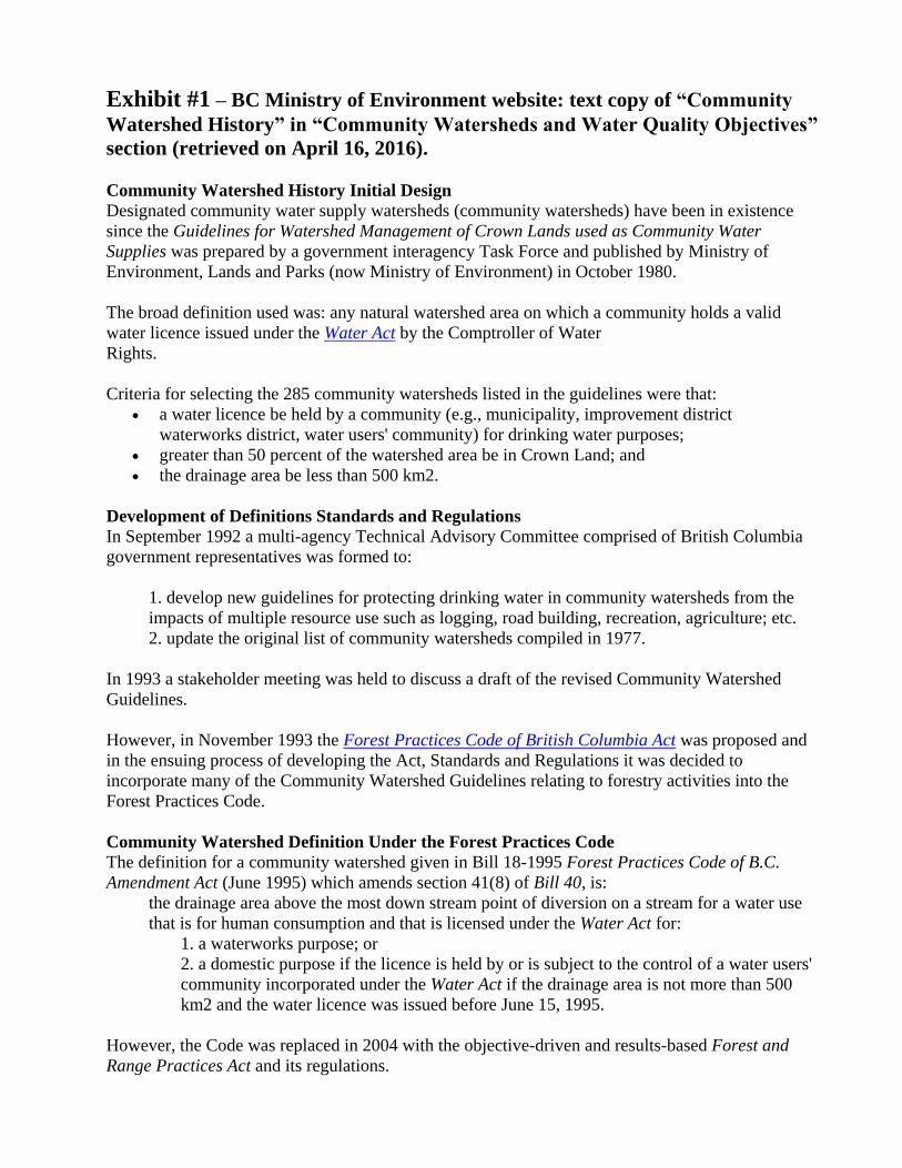
Exhibit #1 – BC Ministry of Environment website: text copy of “Community
Watershed History” in “Community Watersheds and Water Quality Objectives”
section (retrieved on April 16, 2016).
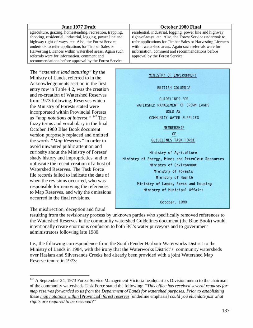
Community Watershed History Initial Design
Designated community water supply watersheds (community watersheds) have been in existence
since the Guidelines for Watershed Management of Crown Lands used as Community Water
Supplies was prepared by a government interagency Task Force and published by Ministry of
Environment, Lands and Parks (now Ministry of Environment) in October 1980.
The broad definition used was: any natural watershed area on which a community holds a valid
water licence issued under the Water Act by the Comptroller of Water
Rights.
Criteria for selecting the 285 community watersheds listed in the guidelines were that:
a water licence be held by a community (e.g., municipality, improvement district
waterworks district, water users' community) for drinking water purposes;
greater than 50 percent of the watershed area be in Crown Land; and
the drainage area be less than 500 km2.
Development of Definitions Standards and Regulations
In September 1992 a multi-agency Technical Advisory Committee comprised of British Columbia
government representatives was formed to:
1. develop new guidelines for protecting drinking water in community watersheds from the
impacts of multiple resource use such as logging, road building, recreation, agriculture; etc.
2. update the original list of community watersheds compiled in 1977.
In 1993 a stakeholder meeting was held to discuss a draft of the revised Community Watershed
Guidelines.
However, in November 1993 the Forest Practices Code of British Columbia Act was proposed and
in the ensuing process of developing the Act, Standards and Regulations it was decided to
incorporate many of the Community Watershed Guidelines relating to forestry activities into the
Forest Practices Code.
Community Watershed Definition Under the Forest Practices Code
The definition for a community watershed given in Bill 18-1995 Forest Practices Code of B.C.
Amendment Act (June 1995) which amends section 41(8) of Bill 40, is:
the drainage area above the most down stream point of diversion on a stream for a water use
that is for human consumption and that is licensed under the Water Act for:
1. a waterworks purpose; or
2. a domestic purpose if the licence is held by or is subject to the control of a water users'
community incorporated under the Water Act if the drainage area is not more than 500
km2 and the water licence was issued before June 15, 1995.
However, the Code was replaced in 2004 with the objective-driven and results-based Forest and
Range Practices Act and its regulations.

Exhibit #2 – Textual examination of “Guidelines for Watershed Management of Crown Lands
Used as Community Water Supplies, October 1980,” Ministry of Environment document, section
4.5, Le Deception a le Blue Book, from Chapter 4 of The Big Eddy.
1
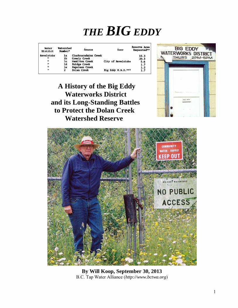
THE BIG EDDY
A History of the Big Eddy Waterworks District and its Long-Standing Battles to Protect the Dolan Creek Watershed Reserve
By Will Koop, September 30, 2013 B.C. Tap Water Alliance (http://www.bctwa.org)
3
TABLE OF CONTENTS Tribute to Colleen McCrory 5 Preface and Acknowledgements 7 Executive Summary 12 1. The Birth of the Big Eddy Waterworks District 22
1.1. 1949-1950: Community Meetings 1.2. Legislation about Improvement and Water Districts 25
2. The Birth of the Dolan Creek Watershed Reserve and Controversies over B.C.’s Early Watershed Reserves 29
2.1. The Big Eddy Trustees Request a Land Act Watershed Reserve 2.1.1. Colonel Parlow’s Proviso 35 2.2. The Greely/ Greeley Creek Connection 39 2.3. Sloan Forest Inquiry and Fresh Water: Early Reserves, Irrigation Districts, Etc. 50
2.3.1. Watershed Reserves 54 2.3.2. Irrigation Districts and the Forest Service 56
2.4. The Erickson Mutual Water Users Request the Government to Protect Sullivan Creek from Logging 74 2.5. The Chief Forester Signals the Invasion of Community Watershed Reserves 76
3. 1952-1965: The Early, Successful Vigilance of Big Eddy against the Forest Service’s Intentions to Log the Dolan Reserve 84
3.1. 1952-1953 - The Forest Service Cancels a Proposed Timber Sale in Dolan Creek 88 3.2. 1964-1965 - The Forest Service Decides Again not to Approve Logging in Dolan Creek 92
4. The Mystery of the Missing Reserves 99
4.1. Solving “The Problem” 106 4.2. The 1969-1974 Okanagan Basin Study 111 4.2.a. Okanagan Basin Logging History 120 4.2.b. Okanagan Reserves as Ogopogo 125 4.3. BC Forest Service Foresters Ordered to Map Register Watershed Reserves 131 4.4. BC’s Watershed Reserves Before 1973 132 4.5. Le Deception a le Blue Book 135 4.6. FLOW Fails to Identify the Reserves 142
5. The Ministry of Health and BC Hydro 147
5.1. The Letter and Questionnaire to Big Eddy and B.C.’S Water Users 148 5.2. Letters from the Ministry of Health 149 5.3. BC Hydro Ignores Internal Orders to Stay Out of Community Watersheds 151 5.4. The Revelstoke Hearings 159 5.5. The October 1976 Urban Systems Report 160 5.6. The September 28th Hearing 164 5.7. The Debate over an Alternate Source 165 5.8. The Transmission Line Construction Period Through Dolan Creek 168
6. The Road to the Environmental Appeal Board 172
6.1. Skirmishes about Additional Funding 6.2. The Grazing Permit Application on BC Hydro’s Right-of-Way 175 6.3. The Environmental Appeal Board Hearing and Findings Create a Provincial Precedent 176
4
7. The Struggle for Control 180 7.1. Water Comptroller Brady and Environment Minister Brummet Troubled Over a Critical Precedent 181 7.2. More Logging Proposals for Dolan Creek 183 7.3. BC’s Chief Forester Wrongly Includes the Dolan Reserve in the Allowable Annual Cut 184 7.4. The Government Notifies the New Guinea Pig 191 7.5. The IWMP Process for Dolan Creek 194
8. The Failed Public Relations Tour of Blewett Creek, Etcetera 204
8.1. The Big Eddy Trustees Fail to Take the Bait 8.2. Too Much At Stake 208 8.3. The Capilano Timber Company 218 8.4. Seattle City’s Cedar River Watershed as National and International Demonstration Propaganda 223 8.5. The Seymour Demonstration Forest (1987–1999) 228 8.6. Recent Reflections by the Ministry of Forests and the Duhamel Creek Uprising 230
9. The Looming Issue of Liability and its Dissipation – A Discussion and Review of Internal Records 237
9.1. Early Legislative Precedent 238 9.2. At the Center: Liability 240 9.3. The South East Kelowna Improvement District Demands Accountability 243 9.4. Union of B.C. Municipalities’ Resolutions Concerning Liability 247
10. The Hot Potatoe - Private Land Ownership Conflicts in Community Watersheds 250
10.1. The Request for Access through Crown Lands on the Dolan Category One Reserve 252 10.2. To Swap, or Not to Swap, 10 Hectares 260 10.3. Thirty Years of Repeated Concerns and Recommendations 270
11. Battling the New Order 289
11.1. Implementation of the 1992 Safe Drinking Water Regulation 290 11.2. The Community that Did - The Battle Against the Devil’s Chemical 294
11.2.1. The Anti-Chlorination League 11.2.2. The Greater Revelstoke Revolt 298
11.3 The End of the Dolan? 310 11.4 The Disappearance Mystery of the Dolan and Greeley Reserves 316 Appendix A – Land Act Reserves Legislation, Lists and Forest Service Ownership Codes 319 Appendix B – Early Newspaper Articles (Revelstoke Herald) and City of Revelstoke City Council Minutes (1909-1911) 328 Appendix C – B.C. Tap Water Alliance Press Release (March 21, 2013) 337 Appendix D – West Coast Environmental Law Association’s Letter to Stan Hagan Regarding Bill 21, May 1, 2002 339 Appendix E – Letter to Revelstoke City Regarding Greeley Creek Watershed Reserve, June 4, 2013, and Revelstoke City Letter, June 3, 2013 341
135
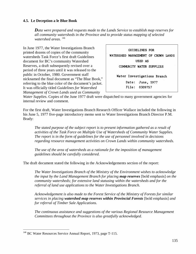
4.5. Le Deception a le Blue Book
Data were prepared and requests made to the Lands Service to establish map reserves for all community watersheds in the Province and to provide status mapping of selected watershed areas. 146
In June 1977, the Water Investigations Branch printed dozens of copies of the community watersheds Task Force’s first draft Guidelines document for BC’s community Watershed Reserves, a draft subsequently revised over a period of three years until it was released to the public in October, 1980. Government staff nicknamed the final document as “The Blue Book,” referring to the blue color of the document’s jacket. It was officially titled Guidelines for Watershed Management of Crown Lands used as Community Water Supplies. Copies of the June 1977 draft were dispatched to many government agencies for internal review and comment. For the first draft, Water Investigations Branch Research Officer Wallace included the following in his June 5, 1977 five-page introductory memo sent to Water Investigations Branch Director P.M. Brady:
The stated purpose of the subject report is to present information gathered as a result of activities of the Task Force on Multiple Use of Watersheds of Community Water Supplies. The report is in the form of guidelines for the use of personnel involved in decisions regarding resource management activities on Crown Lands within community watersheds. The use of the area of watersheds as a rationale for the imposition of management guidelines should be carefully considered.
The draft document stated the following in the Acknowledgements section of the report:
The Water Investigations Branch of the Ministry of the Environment wishes to acknowledge the input by the Land Management Branch for placing map reserves [bold emphasis] on the community watersheds; for extensive land statusing within the watersheds and for the referral of land use applications to the Water Investigations Branch. Acknowledgement is also made to the Forest Service of the Ministry of Forests for similar services in placing watershed map reserves within Provincial Forests [bold emphasis] and for referral of Timber Sale Applications. The continuous assistance and suggestions of the various Regional Resource Management Committees throughout the Province is also greatfully acknowledged.
146 BC Water Resources Service Annual Report, 1973, page T-115.
136
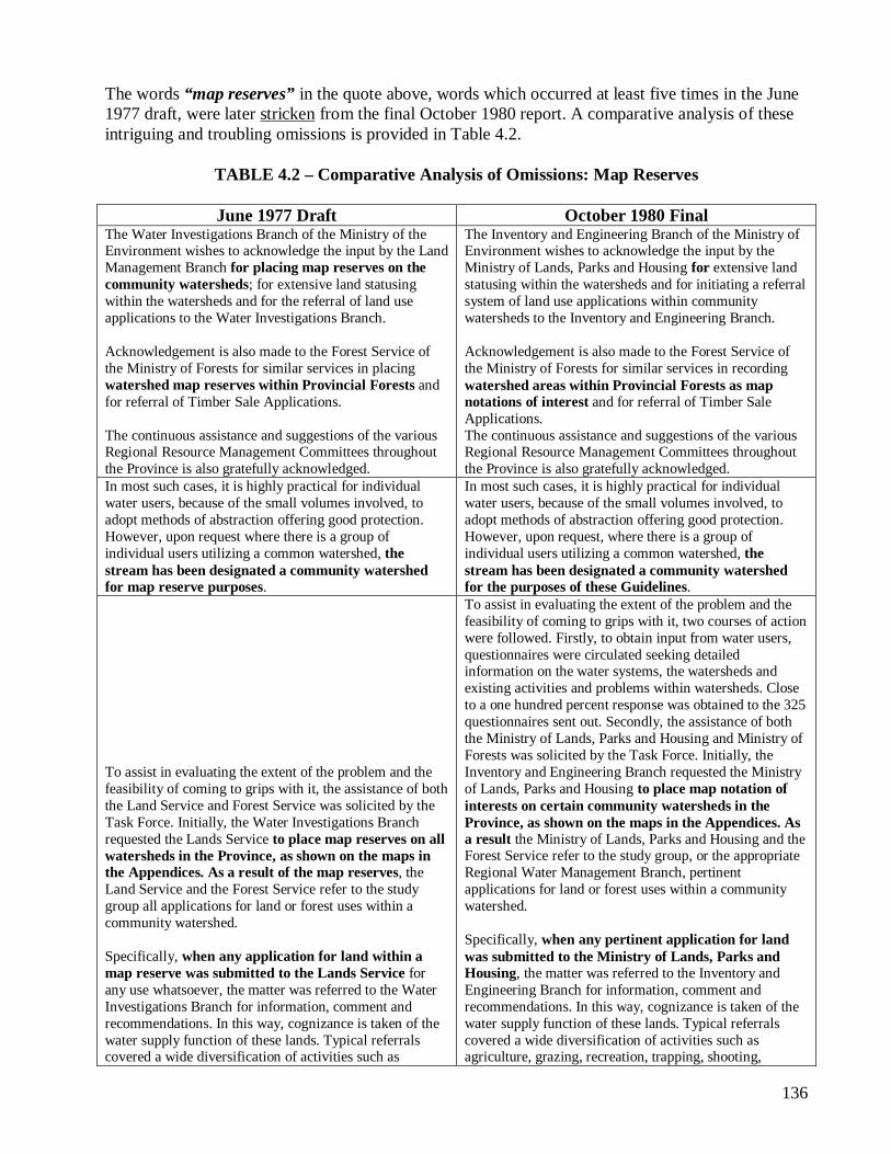
The words “map reserves” in the quote above, words which occurred at least five times in the June 1977 draft, were later stricken from the final October 1980 report. A comparative analysis of these intriguing and troubling omissions is provided in Table 4.2.
TABLE 4.2 – Comparative Analysis of Omissions: Map Reserves
June 1977 Draft October 1980 Final The Water Investigations Branch of the Ministry of the Environment wishes to acknowledge the input by the Land Management Branch for placing map reserves on the community watersheds; for extensive land statusing within the watersheds and for the referral of land use applications to the Water Investigations Branch. Acknowledgement is also made to the Forest Service of the Ministry of Forests for similar services in placing watershed map reserves within Provincial Forests and for referral of Timber Sale Applications. The continuous assistance and suggestions of the various Regional Resource Management Committees throughout the Province is also gratefully acknowledged.
The Inventory and Engineering Branch of the Ministry of Environment wishes to acknowledge the input by the Ministry of Lands, Parks and Housing for extensive land statusing within the watersheds and for initiating a referral system of land use applications within community watersheds to the Inventory and Engineering Branch. Acknowledgement is also made to the Forest Service of the Ministry of Forests for similar services in recording watershed areas within Provincial Forests as map notations of interest and for referral of Timber Sale Applications. The continuous assistance and suggestions of the various Regional Resource Management Committees throughout the Province is also gratefully acknowledged.
In most such cases, it is highly practical for individual water users, because of the small volumes involved, to adopt methods of abstraction offering good protection. However, upon request where there is a group of individual users utilizing a common watershed, the stream has been designated a community watershed for map reserve purposes.
In most such cases, it is highly practical for individual water users, because of the small volumes involved, to adopt methods of abstraction offering good protection. However, upon request, where there is a group of individual users utilizing a common watershed, the stream has been designated a community watershed for the purposes of these Guidelines.
To assist in evaluating the extent of the problem and the feasibility of coming to grips with it, the assistance of both the Land Service and Forest Service was solicited by the Task Force. Initially, the Water Investigations Branch requested the Lands Service to place map reserves on all watersheds in the Province, as shown on the maps in the Appendices. As a result of the map reserves, the Land Service and the Forest Service refer to the study group all applications for land or forest uses within a community watershed. Specifically, when any application for land within a map reserve was submitted to the Lands Service for any use whatsoever, the matter was referred to the Water Investigations Branch for information, comment and recommendations. In this way, cognizance is taken of the water supply function of these lands. Typical referrals covered a wide diversification of activities such as
To assist in evaluating the extent of the problem and the feasibility of coming to grips with it, two courses of action were followed. Firstly, to obtain input from water users, questionnaires were circulated seeking detailed information on the water systems, the watersheds and existing activities and problems within watersheds. Close to a one hundred percent response was obtained to the 325 questionnaires sent out. Secondly, the assistance of both the Ministry of Lands, Parks and Housing and Ministry of Forests was solicited by the Task Force. Initially, the Inventory and Engineering Branch requested the Ministry of Lands, Parks and Housing to place map notation of interests on certain community watersheds in the Province, as shown on the maps in the Appendices. As a result the Ministry of Lands, Parks and Housing and the Forest Service refer to the study group, or the appropriate Regional Water Management Branch, pertinent applications for land or forest uses within a community watershed. Specifically, when any pertinent application for land was submitted to the Ministry of Lands, Parks and Housing, the matter was referred to the Inventory and Engineering Branch for information, comment and recommendations. In this way, cognizance is taken of the water supply function of these lands. Typical referrals covered a wide diversification of activities such as agriculture, grazing, recreation, trapping, shooting,
137
June 1977 Draft October 1980 Final agriculture, grazing, homesteading, recreation, trapping, shooting, residential, industrial, logging, power line and highway right-of-ways, etc. Also, the Forest Service undertook to refer applications for Timber Sales or Harvesting Licences within watershed areas. Again such referrals were for information, comment and recommendations before approval by the Forest Service.
residential, industrial, logging, power line and highway right-of-ways, etc. Also, the Forest Service undertook to refer applications for Timber Sales or Harvesting Licences within watershed areas. Again such referrals were for information, comment and recommendations before approval by the Forest Service.
The “extensive land statusing” by the Ministry of Lands, referred to in the Acknowledgements section in the first entry row in Table 4.2, was the creation and re-creation of Watershed Reserves from 1973 following, Reserves which the Ministry of Forests stated were incorporated within Provincial Forests as “map notations of interest.” 147 The fuzzy terms and vocabulary in the final October 1980 Blue Book document version purposely replaced and omitted the words “Map Reserves” in order to avoid unwanted public attention and curiosity about the Ministry of Forests’ shady history and improprieties, and to obfuscate the recent creation of a host of Watershed Reserves. The Task Force file records failed to indicate the date of when the revisions occurred, who was responsible for removing the references to Map Reserves, and why the omissions occurred in the final revisions. The misdirection, deception and fraud resulting from the revisionary process by unknown parties who specifically removed references to the Watershed Reserves in the community watershed Guidelines document (the Blue Book) would intentionally create enormous confusion to both BC’s water purveyors and to government administrators following late 1980. I.e., the following correspondence from the South Pender Harbour Waterworks District to the Ministry of Lands in 1984, with the irony that the Waterworks District’s community watersheds over Haslam and Silversands Creeks had already been provided with a joint Watershed Map Reserve tenure in 1973:
147 A September 24, 1973 Forest Service Management Victoria headquarters Division memo to the chairman of the community watersheds Task Force stated the following: “This office has received several requests for map reserves forwarded to us from the Department of Lands for watershed purposes. Prior to establishing these map notations within [Provincial] forest reserves [underline emphasis] could you elucidate just what rights are required to be reserved?”
138
There appears to be no legal registration of our watershed other than a listing in Appendix G of the “Guidelines for Watershed Management of Crown Lands used as Community Water Supplies”, dated October 1980. Watershed no 6B, page 23, Haslam Creek, is our only source serving presently some 700 connections. The area is about 11 square miles and includes the Harris Lake drainage area which is also part of our system. 148 Without a legal description and a watershed reserve established, other agencies could claim to be unaware of the existence of the watershed and have no legal requirement to consider the affect of their plans or to advise the South Pender Harbour Waterworks District of such plans. We presently have no authority to control any activity within our watershed, such as logging, camping, spraying, etc. Further, there does not seem to be any requirement that we be advised in advance with respect to any proposed activity within the watershed, either by the public, Government Ministries or B.C. Hydro. Just recently we investigated the plans of the Forest Service in the watershed and found that some logging plans would have had very adverse affects on Haslam Creek water quality. By personal contact and site visits we hope the problems will be overcome but they apparently have neither any obligation to advise us of such plans, nor did they. The same situation occurs in respect to herbicide spraying by either the Forest Service or B.C. Hydro. The only advice required seems to be a legal notice published in a local paper, the descriptions of areas involved are usually less than specific, this means we have to search the papers regularly for possible problems. The Dept. of Health makes regular coliform tests of our water but is not obligated to test for residual herbicide sprays and in any case it would be detected after the fact, not very reassuring to the consumers. We need prior advice. It has become increasingly apparent that we need additional protection against abuses of the watershed which would affect the water quality for some 2,000 users. In referring to page 8 of the “Guidelines”, it specifically states, underlined, “In law, the onus to deliver high quality water to the consumer rests with the water purveyor.” In light of the above facts we request that the ministry establish a Watershed Reserve or some similar legal tenure for the above watershed at the earliest possible date. 149
148 The Task Force should have divided the McNeill Lake / Haslem Creek Map Reserve into two Reserves, instead of one, created over two separate watersheds, Haslem Creek and Silversands Creek. By creating a single reserve, it changed the status of the reserve to a Category 2, for Reserves over 6 square miles. Had the Reserve been divided in two, they each would have fallen under the Category 1 Reserve, for areas under 6 square miles, and been afforded a separate and more powerful protection ranking imposed by the Task Force in their final Blue Book Guidelines report. 149 South Pender Harbour Waterworks District Chairman David H. Maw to Ministry of Lands, Parks and Housing, June 1, 1984. Note: the order of the paragraphs in the original letter has been rearranged here to better focus the theme and arguments.
139
A year and a half before the October 1980 Guidelines document was published, the Township of Spallumcheen, located north of Vernon City, wrote a series of letters over a period of almost 12 months to government administrators about legislative protection of their drinking water sources. In a February 6, 1979 letter to Deputy Forests Minister Mike Apsey, the former executive of the Council of Forest Industries (to which he would soon return as its president!), were questions about Watershed Map Reserves.
Please be advised your letter of January 25th, 1979 was dealt with by Council at a regular meeting of Feb. 5th, 1979. A motion was passed that a letter be sent advising that the reply received was not deemed satisfactory insofar as protection to the Water Shed is concerned. The Municipal Council is of firm opinion that all domestic Water Sheds should be given the ultimate in protection from developments, particularly in the Okanagan area where water is a scarce resource. It is felt that the safeguards outlined do not provide adequate security for the Waterworks District involved. Council is under the impression that neither the Health Unit nor the Pollution Control Branch have any jurisdiction over Crown lands. Council also expressed a wish that your procedure be amended so that relevant authorities in affected areas be allowed to make comments directly to the decision making body. In this case, that would mean Stepney Waterworks District as well as the Township of Spallumcheen. It would further imply that such representations could be made in person to the actual decision making body, in addition to whatever written documentation is considered pertinent. A further question comes to mind, in that your letter referred to “water shed reserves” are noted on legal survey maps and on Forest Service Atlas Maps. It is not clear who decides what a Water Shed Reserve is. It would be appreciated if you could expand on this comment and advise if indeed the Water Rights Branch has taken steps to determine the catchment area and head waters area for such Waterworks systems as Glanzier Creek and Stepney Waterworks District.
Perhaps the Township’s ongoing questions inevitably helped prompt Apsey’s Ministry of Forests’ staff to tidy up and revise the Blue Book Guidelines document in 1980. Deputy Minister Apsey replied to the Township of Spallumcheen’s concerns on March 26, 1979, and recommended that the Township contact J.D. Watts, the chairman of the community watersheds Task Force “if you wish any further information on watershed reserves.” However, Apsey failed to provide any substantive policy and legislative information about Watershed Reserves to the Township, and incorrectly inferred that the community watersheds, which had all been tenured as Map Reserves under the Land Act, were “subject to multiple use.”
I acknowledge your letter of February 8, 1979 in which you express the concern of your Council about the protection measures given to domestic watersheds.
140
In 1972 a Provincial government Task Force was formed to investigate the practicality 150 of obtaining a wholesome water supply from streams, the watersheds of which are subject to multiple use, and to recommend policy and procedures for the management of land use conflicts within watersheds. As a result of their investigations a set to proposed guidelines has been prepared for the management of Crown land within community water supply watersheds. The proposed guidelines are intended for use by various Crown agencies responsible for resource use, construction or development on Crown lands within watersheds. As a water user you would have been contacted by the task force on Multiple Use of Watersheds of Community Water Supplies and I must assume that you are fully aware of the proposals. Watershed reserves are established through the Water Investigations Branch of the Ministry of Environment. The Land Management Branch of the Ministry of Lands, Parks and Housing and in the case of provincial forests, the Forest Service place community watershed map reserves on their ministry reference maps for inter-ministerial referral and consultative purposes.
Following a subsequent series of letters between the Township of Spallumcheen and the government, on December 7, 1979 the Township wrote the following to Minister of Forests Tom Waterland:
For many years the Township of Spallumcheen, and as well the city of Armstrong, have been concerned about the quality and quantity of the water resource which services these Municipalities. The source of course is Crown land to the East of Spallumcheen boundaries. At the Council meeting of December 3rd, 1979, a motion was passed to request some form of tenure or reserve over these lands. The motion designated the areas which serve as Watersheds, Head Waters or catchment Areas for the supply of domestic water in Spallumcheen. The Municipality, therefore, would like a statement from your Ministry as to the possibility of being granted some form of tenure, whether it would be by reserve, permit, tree farm 151 or outright purchase. An identical letter is being written to the Minister of Lands, Parks & Housing, the Honourable James Chabot and the Minister of the Environment, the Honourable C.S. Rogers. The same question is being put to all three Ministers, in the hope that some positive program could be established which would once and for all give the citizens of these communities peace of mind regarding their water resource. Your assistance is sincerely appreciated.
Evidently, the Social Credit government was reluctant to properly inform the Township of what its rights were, or what the Land Act powers were with respect to Map Reserves or Order-in-Council
150 Apsey was incorrect here. The actual term used in the Task Force Terms of Reference states “practicability” (i.e., feasibility), not “practicality.” The definitions for each are distinctly different. 151 It is odd that the Township would have requested a Tree Farm. A likely explanation to this confusion is that the Greater Vancouver Water District had agreed to a quasi-Tree Farm License over its three watersheds in 1967, and that the Township inadvertently and incorrectly thought this was a form of tenured protection.
141
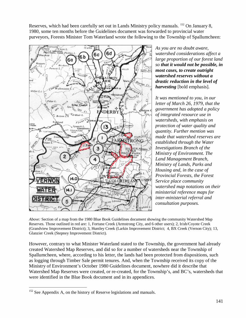
Reserves, which had been carefully set out in Lands Ministry policy manuals. 152 On January 8, 1980, some ten months before the Guidelines document was forwarded to provincial water purveyors, Forests Minister Tom Waterland wrote the following to the Township of Spallumcheen:
As you are no doubt aware, watershed considerations affect a large proportion of our forest land so that it would not be possible, in most cases, to create outright watershed reserves without a drastic reduction in the level of harvesting [bold emphasis]. It was mentioned to you, in our letter of March 26, 1979, that the government has adopted a policy of integrated resource use in watersheds, with emphasis on protection of water quality and quantity. Further mention was made that watershed reserves are established through the Water Investigations Branch of the Ministry of Environment. The Land Management Branch, Ministry of Lands, Parks and Housing and, in the case of Provincial Forests, the Forest Service place community watershed map notations on their ministerial reference maps for inter-ministerial referral and consultation purposes.
Above: Section of a map from the 1980 Blue Book Guidelines document showing the community Watershed Map Reserves. Those outlined in red are: 1, Fortune Creek (Armstrong City, and 6 other users); 2, Irish/Coyote Creek (Grandview Improvement District); 3, Huntley Creek (Larkin Improvement District; 4, BX Creek (Vernon City); 13, Glanzier Creek (Stepney Improvement District). However, contrary to what Minister Waterland stated to the Township, the government had already created Watershed Map Reserves, and did so for a number of watersheds near the Township of Spallumcheen, where, according to his letter, the lands had been protected from dispositions, such as logging through Timber Sale permit tenures. And, when the Township received its copy of the Ministry of Environment’s October 1980 Guidelines document, nowhere did it describe that Watershed Map Reserves were created, or re-created, for the Township’s, and BC’s, watersheds that were identified in the Blue Book document and in its appendices.
152 See Appendix A, on the history of Reserve legislations and manuals.
Exhibit #3 – Chapter 8.4, The 1990s: The Forest Resources Commission, Land Use Plans
(LUPs), Land and Resource Management Plans (LRMPs) and the Forest Practices Code Act, in
Will Koop’s June 2006 book, From Wisdom to Tyranny: A History of British Columbia’s
Drinking Watershed Reserves.
Three prominent features distinguished the 1990s from previous decades:
• First, government deliberately ignored Land Act Watershed Reserves in numerous provincial Higher Level Planning processes related to the development of the 1995 Forest Practices Code Act. Government also ignored the Reserves following the passage of the Act. Reserves and domestic water sources not reserved were then defined under a new program of Special Resource Management (SRM).
• Second, the government began planning programs for community watersheds “en masse.” Instead of embar-king on intensive planning processes for individual community watersheds under Integrated Watershed Management Plans (IWMPs), the new strategy was to quietly slip in regional and sub-regional planning initiatives, where dozens of Watershed Reserves and community watersheds not reserved were all thrown into the same blender. This was particularly noticeable in areas where communities regularly opposed resource management proposals and contrasted starkly with the initiatives of previous decades, when community watersheds received protection.
• Third, to conform to the above strategy, the IWMP policy developed in the 1980s was quietly put out to pasture, even though it was never rescinded.
What stakeholders were not made aware of during these and other regional and sub-regional planning processes was the existence and legislative significance of the Land Act Watershed Reserves. As a result, in negotiations over the 12 percent cap on Crown land protection, lobbying for provincial parks took precedence over all other protective designations, largely throwing the unacknowledged Watershed Reserves and unreserved community watersheds into relative obscurity.
The Land Use Plans, Land and Resource Management Plans and Local Resource Use Plans that heralded logging in BC’s drinking watersheds throughout the 1990s were powerful instruments. They became almost insurmountable obstacles for water users, who had been struggling for decades to prevent
resource use in their water supply areas. Many communities, even those with Land Act Watershed Reserves, became pawns in a cutthroat chess game where water sources were targeted for alternative logging proposals under the new banner of community forest tenures. For instance, the Central Kootenay Regional District, which had been a strong proponent in the 1980s for the protection of drinking watersheds, was manoeuvred in 1997 into becoming a shareholder of the Creston Valley Forest Corporation, which logged in three Watershed Reserves near Creston: Arrow Creek, Sullivan Creek and Camp Run Creek.
Land Act Community Watershed Reserves are legal and statutory entities. Because their status was not formally recognized and considered during the regional and sub-regional planning processes (and was, in fact, neglected and ignored), it can be argued that those processes were illegitimate.
8.4.1. The Commission on Forest Resources
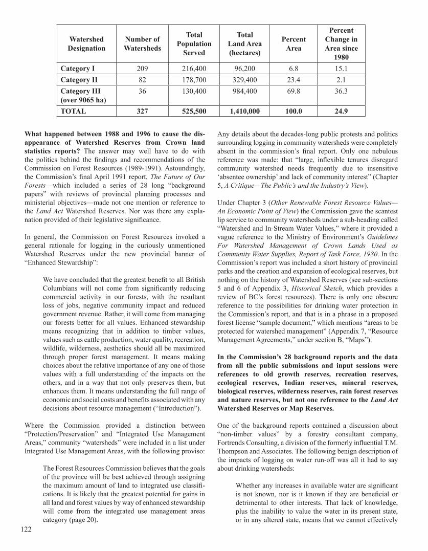
Important information about Watershed Reserves was omitted from British Columbia Land Statistics, prepared by the Tenure Management Branch of the Ministry of Lands and published in February 1996. Attached to the title of Table 36, “Status of Community Watersheds—1994,” was a footnote that stated:
Since 1987 there has been a major rewriting of the Community Guidelines and there is a new definition of community watersheds. The Category I to III based on drainage area has been dropped.
Seven years earlier, in British Columbia Land Statistics (published in March 1989 by the Ministry of Crown Lands), information on existing Watershed Reserves was provided by category under Table 38, Status of Community Watersheds in British Columbia—1987. A footnote stated that these statistics used February 1988 “unpublished data” from the Ministry of Environment, Water Management Branch, Hydrology Section. Of great interest was the data indicated that the government had created an additional 50 Category One Watershed Reserves since 1980. Here is the table from the 1989 BC Land Statistics report:
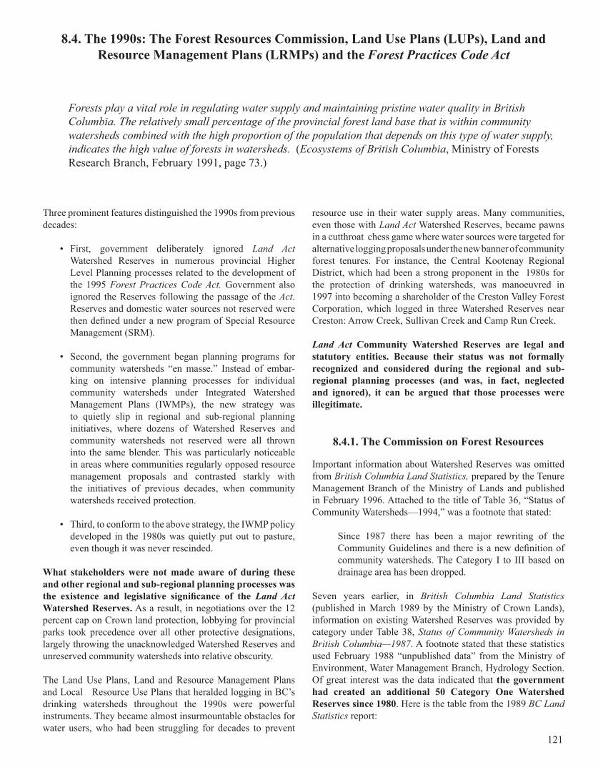
8.4. The 1990s: The Forest Resources Commission, Land Use Plans (LUPs), Land and Resource Management Plans (LRMPs) and the Forest Practices Code Act
Forests play a vital role in regulating water supply and maintaining pristine water quality in British Columbia. The relatively small percentage of the provincial forest land base that is within community watersheds combined with the high proportion of the population that depends on this type of water supply, indicates the high value of forests in watersheds. (Ecosystems of British Columbia, Ministry of Forests Research Branch, February 1991, page 73.)
121
What happened between 1988 and 1996 to cause the dis-appearance of Watershed Reserves from Crown land statistics reports? The answer may well have to do with the politics behind the findings and recommendations of the Commission on Forest Resources (1989-1991). Astoundingly, the Commission’s final April 1991 report, The Future of Our Forests—which included a series of 28 long “background papers” with reviews of provincial planning processes and ministerial objectives—made not one mention or reference to the Land Act Watershed Reserves. Nor was there any expla-nation provided of their legislative significance.
In general, the Commission on Forest Resources invoked a general rationale for logging in the curiously unmentioned Watershed Reserves under the new provincial banner of “Enhanced Stewardship”:
We have concluded that the greatest benefit to all British Columbians will not come from significantly reducing commercial activity in our forests, with the resultant loss of jobs, negative community impact and reduced government revenue. Rather, it will come from managing our forests better for all values. Enhanced stewardship means recognizing that in addition to timber values, values such as cattle production, water quality, recreation, wildlife, wilderness, aesthetics should all be maximized through proper forest management. It means making choices about the relative importance of any one of those values with a full understanding of the impacts on the others, and in a way that not only preserves them, but enhances them. It means understanding the full range of economic and social costs and benefits associated with any decisions about resource management (“Introduction”).
Where the Commission provided a distinction between “Protection/Preservation” and “Integrated Use Management Areas,” community “watersheds” were included in a list under Integrated Use Management Areas, with the following proviso:
The Forest Resources Commission believes that the goals of the province will be best achieved through assigning the maximum amount of land to integrated use classifi-cations. It is likely that the greatest potential for gains in all land and forest values by way of enhanced stewardship will come from the integrated use management areas category (page 20).
Any details about the decades-long public protests and politics surrounding logging in community watersheds were completely absent in the commission’s final report. Only one nebulous reference was made: that “large, inflexible tenures disregard community watershed needs frequently due to insensitive ‘absentee ownership’ and lack of community interest” (Chapter 5, A Critique—The Public’s and the Industry’s View).
Under Chapter 3 (Other Renewable Forest Resource Values—An Economic Point of View) the Commission gave the scantest lip service to community watersheds under a sub-heading called “Watershed and In-Stream Water Values,” where it provided a vague reference to the Ministry of Environment’s Guidelines For Watershed Management of Crown Lands Used as Community Water Supplies, Report of Task Force, 1980. In the Commission’s report was included a short history of provincial parks and the creation and expansion of ecological reserves, but nothing on the history of Watershed Reserves (see sub-sections 5 and 6 of Appendix 3, Historical Sketch, which provides a review of BC’s forest resources). There is only one obscure reference to the possibilities for drinking water protection in the Commission’s report, and that is in a phrase in a proposed forest license “sample document,” which mentions “areas to be protected for watershed management” (Appendix 7, “Resource Management Agreements,” under section B, “Maps”).
In the Commission’s 28 background reports and the data from all the public submissions and input sessions were references to old growth reserves, recreation reserves, ecological reserves, Indian reserves, mineral reserves, biological reserves, wilderness reserves, rain forest reserves and nature reserves, but not one reference to the Land Act Watershed Reserves or Map Reserves.
One of the background reports contained a discussion about “non-timber values” by a forestry consultant company, Fortrends Consulting, a division of the formerly influential T.M. Thompson and Associates. The following benign description of the impacts of logging on water run-off was all it had to say about drinking watersheds:
Whether any increases in available water are significant is not known, nor is it known if they are beneficial or detrimental to other interests. That lack of knowledge, plus the inability to value the water in its present state, or in any altered state, means that we cannot effectively
WatershedDesignation
Number ofWatersheds
Total Population
Served
Total Land Area (hectares)
Percent Area
Percent Change in Area since
1980Category I 209 216,400 96,200 6.8 15.1Category II 82 178,700 329,400 23.4 2.1Category III (over 9065 ha)
36 130,400 984,400 69.8 36.3
TOTAL 327 525,500 1,410,000 100.0 24.9
122
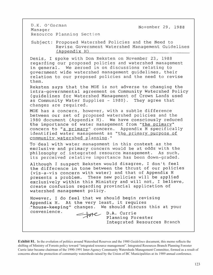
Exhibit 81. In the evolution of politics around Watershed Reserves and the 1980 Guidelines document, this memo reflects the shifting of Ministry of Forests policy toward “integrated resource management”. Integrated Resources Branch Planning Forester Currie later became chairman of the 1990-1991 Inter-Agency Community Watersheds Management Committee, formed as a result of concerns about the protection of community watersheds raised by the Union of BC Municipalities at its 1989 annual conference.
123
account for the relation between other uses of the forest and the water resource. We have not, therefore developed quantitative indicators for the water resource for inclusion in the accounts of the forest estate. That does not mean that the water resource would be ignored in forest management. (Forest Resource Management Alternatives Study, Fortrends Consulting, March 1991; Appendix III, “Incorporation of Non-Timber Values in Forest Management, Water Resources,” page III-3.)
As far as the future of BC’s Crown land planning processes were concerned, the Commission on Forest Resources made two important, inter-related recommendations: the immediate development of legally binding land use planning processes through a new process of public participation, and the development of a new forest stewardship or practices code over BC’s extensive Crown lands.
The effective use of land and its resources has from the beginning of time shaped our progress and evolution. All societies—primitive or advanced—have had a vision of the land and based their social structure on that vision. With that in mind, the Forest Resources Commission believes that any effort to protect and enhance the many values represented by British Columbia’s land base must begin with a comprehensive Land Use Plan. From that plan, and fully integrated with it, will flow a variety of management systems designed to make the best use of all those values. . . . The Forest Resources Commission has concluded that a comprehensive Land Use Plan is required to accommodate that new, fuller range of values and to allow the introduction of additional values as society changes its outlook. The Land Use Plan will be a blueprint for managing this change.
The process envisaged for the Land Use Plan must be open, neutral, and balanced. High quality land steward-ship is possible only if it is kept arms-length from the influence of short-term economic or political aspirations. Current land use mechanisms are shared among several provincial government ministries (Forests, Environment, Parks, etc.) each with an advocacy position and with a profusion of overlapping jurisdictions and conflicting goals. For that reason, none of those ministries—Forests, Environment, Parks, etc.—is an acceptable administrator of a comprehensive Land Use Plan designed to reflect all values. Each brings a bias of one kind or another to the table. The Forest Resources Commission believes a restructured Ministry of Crown Lands, with a mandate to ensure the optimum balance of activities on all provincial Crown lands, should coordinate all Land Use Planning functions. It will be best equipped to ensure that the Land Use Plan functions as objectively as possible, with the best interests of all British Columbians in mind. . . . Where appropriate, management protocols such as are currently in place between the Ministry of Crown Lands and the Ministry of Forests could be entered into with the new Forest Management structure recommended in this
report. This should in no way impair the ministry’s ability to carry out objectively its administrative responsibi-lities over the Land Use Plan. (Chapter 3, “Land Use Planning”; Section 1, “A Blueprint for Diversity”.)
Because the Commission made no mention of the hundreds of Watershed Reserves in force at that time, and did not describe their legal or legislative significance, it is not surprising that the Reserves were never mentioned at formal land planning processes in the future.
A May 1992 report, Forest Practices Code Background Papers, also made no reference to Watershed Reserves. Such was not the case, however, in a submission to the Forest Practices Code Act entitled A Catalogue of Forest Practices Guidelines and Regulations in British Columbia. Under a section entitled “Water,” the submission mentioned Appendix H and the 1980 Guidelines for Water Management of Crown Lands Used as Community Water Supplies. It also described a number of completed and ongoing Integrated Watershed Management Plans (for Mark Creek, Penticton Creek, Naramata Creek and Springer Creek). Somehow overlooked in the list of IWMPs were Pemberton Creek, Dolan Creek, Duck/Arrow creeks and Chapman/Gray creeks, also in force at that time.
8.4.1.1. The Ecosystems of BC Research Report Emphasizes and Affirms “Intact Forest Cover”
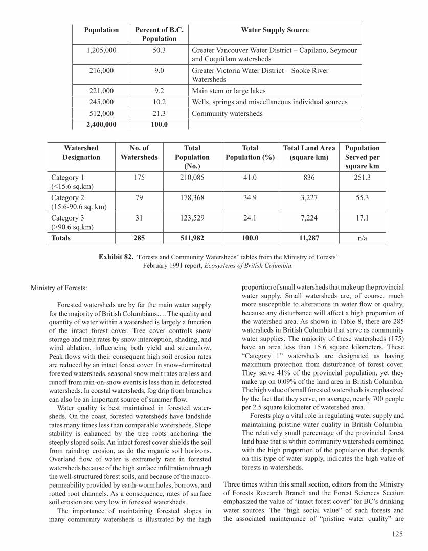
Two months before the Commission on Forest Resources’ final report was completed, the Ministry of Forests Research Branch published the Ecosystems of British Columbia (Special Report Series 6, February 1991). It contained a small but significant one and half page section entitled Forests and Community Watersheds. The following two tables (Exhibit 82) are from that report: one has statistics on population and drinking source types, and the other provides details about existing provincial Watershed Reserves (though not specifically identified as such in the report).
Notably, the Watershed Reserve Category totals are at variance with the 1989 BC Lands Statistics report published less than two years previously: Thirty-four Category One Reserves have been removed, Category Two Reserves have increased by three, and Category Three has increased by five. The significant decrease in Category One Reserves is troubling. These small community water sources are extremely sensitive to disturbance hence their Category One designation. There appears to have been a secretive undertaking to convert them to “un-statutory” designations (see Chapter 11.3 for a description). Although still called community watersheds, they have been re-designated under the Forest Practices Code, which may not have been legal.
The section of the Ecosystems of British Columbia report dedicated to the public’s drinking water sources made the following critical statements, which had been carefully synthesized from numerous research studies and forest related disciplines. This was possibly the last such report made by the
124
Ministry of Forests:
Forested watersheds are by far the main water supply for the majority of British Columbians…. The quality and quantity of water within a watershed is largely a function of the intact forest cover. Tree cover controls snow storage and melt rates by snow interception, shading, and wind ablation, influencing both yield and streamflow. Peak flows with their consequent high soil erosion rates are reduced by an intact forest cover. In snow-dominated forested watersheds, seasonal snow melt rates are less and runoff from rain-on-snow events is less than in deforested watersheds. In coastal watersheds, fog drip from branches can also be an important source of summer flow.
Water quality is best maintained in forested water-sheds. On the coast, forested watersheds have landslide rates many times less than comparable watersheds. Slope stability is enhanced by the tree roots anchoring the steeply sloped soils. An intact forest cover shields the soil from raindrop erosion, as do the organic soil horizons. Overland flow of water is extremely rare in forested watersheds because of the high surface infiltration through the well-structured forest soils, and because of the macro-permeability provided by earth-worm holes, borrows, and rotted root channels. As a consequence, rates of surface soil erosion are very low in forested watersheds.
The importance of maintaining forested slopes in many community watersheds is illustrated by the high
proportion of small watersheds that make up the provincial water supply. Small watersheds are, of course, much more susceptible to alterations in water flow or quality, because any disturbance will affect a high proportion of the watershed area. As shown in Table 8, there are 285 watersheds in British Columbia that serve as community water supplies. The majority of these watersheds (175) have an area less than 15.6 square kilometers. These “Category 1” watersheds are designated as having maximum protection from disturbance of forest cover. They serve 41% of the provincial population, yet they make up on 0.09% of the land area in British Columbia. The high value of small forested watersheds is emphasized by the fact that they serve, on average, nearly 700 people per 2.5 square kilometer of watershed area.
Forests play a vital role in regulating water supply and maintaining pristine water quality in British Columbia. The relatively small percentage of the provincial forest land base that is within community watersheds combined with the high proportion of the population that depends on this type of water supply, indicates the high value of forests in watersheds.
Three times within this small section, editors from the Ministry of Forests Research Branch and the Forest Sciences Section emphasized the value of “intact forest cover” for BC’s drinking water sources. The “high social value” of such forests and the associated maintenance of “pristine water quality” are
Population Percent of B.C. Population
Water Supply Source
1,205,000 50.3 Greater Vancouver Water District – Capilano, Seymour and Coquitlam watersheds
216,000 9.0 Greater Victoria Water District – Sooke River Watersheds
221,000 9.2 Main stem or large lakes245,000 10.2 Wells, springs and miscellaneous individual sources512,000 21.3 Community watersheds
2,400,000 100.0
Watershed Designation
No. of Watersheds
Total Population
(No.)
Total Population (%)
Total Land Area (square km)
Population Served per square km
Category 1(<15.6 sq.km)
175 210,085 41.0 836 251.3
Category 2(15.6-90.6 sq. km)
79 178,368 34.9 3,227 55.3
Category 3(>90.6 sq.km)
31 123,529 24.1 7,224 17.1
Totals 285 511,982 100.0 11,287 n/a
Exhibit 82. “Forests and Community Watersheds” tables from the Ministry of Forests’ February 1991 report, Ecosystems of British Columbia.
125
clearly reported by Ministry of Forests’ researchers to be tied to the maxim of “intact forest cover”. Nevertheless, such an emphasis, which maintains the long-held tradition of protecting these sources, is the complete antithesis of the objectives of the Ministry of Forests. Based on the decades-old policy of “sympathetic administration”, the Ministry of Forests had been licencing intrusions into the Watershed Reserves, especially the Category Ones, which had been designated to be afforded “maximum protection”. As a result, this important information provided by the Ministry of Forests’ Research Branch was not incorporated in the Forest Resource Commission’s final report.
8.4.1.2. The Resource Inventory Committee’s Watershed Task Force
The Forest Resources Commission’s final April 1991 report kick-started a provincial resource inventory process, the formation of the Forest Resource Inventory Committee, renamed in 1992 as the Resource Inventory Committee (RIC), a shared federal and provincial responsibility. As stated in the RIC’s Water and Watershed Task Force May 1992 report, the Forest Resources Commission “emphasized that “good inventory information is vital to the land use planning process” and recommended that the provincial government undertake a commitment to complete inventories for all renewable forest values using standardized compatible systems” ” [bold emphasis] (pages 3-4). In association, the BC Land Information Strategic Committee (LISC) “is responsible for ensuring that data sets are consistent, exchangeable and can be used in land use planning in British Columbia” (Ibid., page 5). As explained in the Watershed Task Force report, the LISC was an outcome of the development in 1989 of the Corporate Land Information Strategic Plan, “to enhance the sharing and exchange of land related information across government” (page 38). Together, the RIC and the LISC were responsible for “developing and disseminating land information” to support the newly formed Commission on Resources and Environment (CORE) that was “established to independently and publicly advise Cabinet on Legislation, policy and allocation decisions related to all land use issues and processes in British Columbia” (page 39). The obvious question remains: if government resource agencies were mandated to provide “good inventory information”, then why were the Land Act Watershed Reserves not being accounted for?
The RIC initially consisted of one Task Force, the Timber Inventory Task Force, which was mandated to “review the current Ministry of Forests Inventory Program and to design and plan the development of a new provincial timber inventory process” (Report of the Timber Inventory Task Force, April 1992, Preamble). Recommendations followed to establish “an integrated multi-resource inventory task force(s) effort to parallel and integrate with the work of the Timber Inventory Task Force” (ibid. page 5). The RIC then delegated the establishment of seven additional Task Forces, which included the Water and Watershed Task Force. It was established in November 1991 as a result of a recommendation by G.G. Runka Land Sense
Ltd. in the November 1991 report Forest Resource Inventory Committee Multi-resource Inventory Task Force Study: “With increasing public concern about water quality, quantity and watershed management issues, it is my view that a task force to pursue associated inventory issues is warranted” (Section 1.4 of the Task Force report).
Jim Mattison, the Director of the Ministry of Environment, Lands and Parks Hydrology Branch was appointed chairman of the Watershed Task Force, and Brian Turner, Senior Environmental Planner with the Integrated Management Branch, as co-chair. Two of the 14 member Task Force were Barry Willoughby with the Ministry of Health’s Public Health Protection, and Steve Chatwin with the Ministry of Forests Research Branch, who also chaired the provincial Community Watershed Guidelines Committee (1992-1993) responsible for creating the 1996 Community Watershed Guidelines Guidebook for the Forest Practices Code Act legislation. Included in the Watershed Task Force’s Terms of Reference was a questionnaire sent to “67 inventory holders and 155 users of water and watershed information”. The Task Force’s objectives included the determination of “what information is vital for effective land management, at what level of detail, and for what purposes.” Explained in section 4.2, How Inventories Meet Present Land Use Needs:
Water and watershed inventories meet current land use needs in a variety of ways. These inventories assist in resource protection, management, status and impact assessment, and in land use planning. Specific examples of how inventories meet present land use needs include: … assisting in resolving land use conflicts, land use planning … protecting the environment ….
In both the RIC’s Timber Inventory and Watershed Task Force reports, there is no accounting of or reference made to the provincial Watershed Reserves.
8.4.2. 1992 Following: The Introduction of New Land Planning Legislation
The June 1993 protocol agreement between the Ministry of Forests and BC Lands identified that they were to consult together about Watershed Reserves in the newly legislated public planning processes introduced in 1992:
Actions will be responsive to land use planning processes developed by the Commission on Resources and the Environment and approved by government and, Land and Resource Management Plans and Local Resource Use Plans, Crown Land Plans, Protected Areas Strategy, and local government plans. Decisions will be taken in the context of these plans and processes where they exist (Section 3.0, “Principles”; Sub-Section 3.3, “Planning”).
After the ugly ’80s, the New Democratic Party government (October 1991-May 2001) instituted BC’s first rigorous,
126
province-wide land planning processes. These also included new forms of public participation. The 1989-1991 Commission on Forest Resources had recommended significant changes for forest management planning and the inclusion of citizen participation, and the new government turned the table on the old boys’ network by unlocking many doors previously closed to the public—or so it seemed.
The transition in British Columbia towards meaningful public participation and balanced sustainability is just beginning. (Vancouver Island Land Use Plan, Volume One, Commission on Resources and Environment, February 1994, page 1.)
Largely forgotten was the fact that the provincial Social Credit and federal Liberal governments were responsible for the first-ever review process with public participation: the Canada-British Columbia Okanagan Basin Agreement, which provided for water planning in the Okanagan Basin in southern BC (1969-1974). An account of this process is provided in a 485-page technical supplement, Public Involvement in the Planning Process, and is summarized in the final 1974 Okanagan Basin Main Report.
In essence, the NDP reactivated the spirit of the 1971 Environment and Land Use Act, which had engaged provincial land use issues in a meaningful, responsible manner through a cabinet committee (see 9.3.4 below for a summary). A semblance of that Act was still in place, though dormant, but instead of re-invoking a special cabinet committee, the NDP made one agent accountable for the new planning processes. On June 23, 1992, as part of its unfolding Provincial Land Use Strategy, the government created the Commissioner on Resources and Environment Act (CORE). The Act gave enormous powers to an “independent” commissioner, Stephen Owen (now in his third term as a federal member of parliament), who reported directly to the Executive Council regarding “land use and related resource and environmental issues in British Columbia and on the need for legislation, policies and practices respecting these issues.” Owen’s mandate allowed him to conduct formal legal hearings as laid out in the provincial Inquiry Act. The CORE Act stipulated that the Commissioner “shall give due consideration to (a) economic, environmental and societal interests, (b) local, Provincial and federal governmental responsibilities, and (c) the interests of Aboriginal peoples.”
This new approach to land planning was proclaimed in the Provincial Land Use Charter, which the government “adopted in principle” in 1993:
1. The province shall maintain and enhance the life-supporting capacity of air, water, land and ecosystems. The Province shall respect the integrity of natural systems, and will seek to restore previously degraded environments. 2. The Province shall conserve biological diversity in genes, species and ecosystems. 3. The Province shall attempt to anticipate and prevent
adverse environmental impacts. When making land and resource decisions, the Province shall exercise caution and special concern for natural values, recognizing that human understanding of nature is incomplete. 4. The Province shall ensure that environmental and social costs are accounted for in land, resource use and economic decisions.5. The Province shall recognize its responsibility to protect the global environment, to reduce consumption to sustainable levels, to avoid importing or exporting ecological stresses, and to meet the global challenge of sustainably supporting the human population.6. The Province shall protect the environment for human uses and enjoyment, and will also respect the intrinsic value of nature.
8.4.3. Land Use Plans (LUPs) and Land Resource Management Plans (LRMPs)
What the province was not about to protect, despite the glossy veneer of its Land Use Charter, were the Land Act Watershed Reserves and the drinking watersheds not reserved. This was made quite apparent to BC water users, particularly those in the Kootenays who had been waging battles against the government for decades. It was painstakingly clear to community activists in the Sunshine Coast Regional District northwest of Vancouver, who were participating in an Integrated Watershed Management Planning process for their area but were being mysteriously stonewalled by the Ministry of Forests about two Watershed Reserves (see Chapter 9.1.1).
In the larger provincial planning context, deceptions about Watershed Reserves were also unfolding, but hardly anyone paid any attention to these designations because government agencies avoided mentioning them during numerous public planning processes. Government certainly offered no protection for community/ domestic watershed sources at these planning tables. Provincial water users were still being duped, despite pre-election promises made to the public that the Reserves would all be legislatively protected.
With the exception of the Kamloops Land and Resource Management Plan (LRMP), which got underway earlier, numerous regional and sub-regional planning processes started up after the NDP government was elected in late 1991 and the Forest Resources Commission had concluded its work. Watershed Reserves and unreserved community and domestic watersheds came under review. According to the November 1993 LRMP Public Participation Guidelines, a total of 40 LRMPs were scheduled for the entire province. Three regional Land Use Plans and most of the sub-regional LRMPs were complete by the end of the millennium, with a few still in progress. The following is a complete list (as currently registered on the website of the Ministry of Sustainable Resource Management):
127
• Land Use Plans: Vancouver Island; Cariboo Chilcotin; East and West Kootenay-Boundary; Haida Gwaii/Queen Charlotte Islands (underway).
• Land and Resource Management Plans: Central Coast; North Coast; Sea-to-Sky (underway); Dawson Creek; Fort Nelson; Fort St. James; Fort St. John; Mackenzie; Prince George; Robson Valley; Vanderhoof; Bulkley; Cassiar Iskut-Stikine; Kalum; Kispiox; Lakes; Morice; North Coast; Kamloops (the first LRMP); Lillooet; and Okanagan-Shuswap.
Both of these planning processes, along with Special Interim Management Processes, Local Resource Use Plans, Landscape-Level Plans and Total Resource Plans, are also approved Higher Level Plans, as defined in the government’s June 1996 Forest Practices Code: Higher Level Plans, Policy and Procedures:
The provincial government has introduced the Forest Practices Code as an important component of its overall, integrated strategy for land use planning and resource management in British Columbia. The Code introduces a number of new forest planning approaches and redefines others. Code development was guided by the desire to build on the many established planning processes and recent planning improvements.
This principle will ensure that valuable direction from regional plans, land and resource management plans and local resource use plans can be incorporated into the Code framework. These plans are prepared outside of the Forest Practices Code under other legislation or policy; however, through the concept of higher level plans, they can serve to legally influence forest practices under the Code. The Lieutenant Governor in Council, the ministers, the chief forester, regional managers, district managers and designated environment officials are now legally mandated to forge this link between the Code and the broader provincial planning framework.
Planning under the Forest Practices Code is separated into two levels: higher level planning and operational planning. Higher level plans include those plans specified in Part 2 of the Act—Strategic Planning, Objectives and Standards—and plans produced under certain non-code legislation or policy as specified in section 1(1) of the Act.
Higher level plans establish the broader, strategic context for operational plans, providing objectives that determine the mix of forest resources to be managed in a given area. They fall into two categories:
1. Plans that are directly enabled through Part 2 of the Forest Practices Code of British Columbia Act. These include objectives for the following: resource management zones, landscape units, sensitive areas, interpretive forest sites, recreation sites and recreation trails. 2. Plans that are developed under non-Code legislation or policy. These include the following: (a) plans or agreements declared
to be higher level plans by the Lieutenant Governor in Council (also referred to as Cabinet) or the ministers; (b) plans formulated pursuant to section 4(c) of the Ministry of Forests Act, which are designated as higher level plans by the district manager in accordance with direction from the chief forester; and (c) management plans, which may be designated as higher level plans by the chief forester for tree farm licences, and by the regional manager for other agreements under the Forest Act.
This second group of plans, except certain management plans, may be designated or declared for all Crown land.
In a broader sense, higher level plans refer to plans, agreements or objectives as defined in the Forest Practices Code. They are a “higher level” relative to operational plans and are the primary source of objectives that play an important role in determining the forest practices described in an operational plan. A plan such as the Kamloops Land and Resource Management Plan may be approved as government policy. However, this approval does not make it a higher level plan. It, or a portion of the plan, must first be formally declared by the Lieutenant Governor in Council or the ministers as a higher level plan before the provisions of the Code concerning these plans can apply. The same general concept (with different approving authorities) applies to other higher level plans (Sections 2.1, 2.2).
The Kamloops LRMP, which began in 1989, was the first provincial LRMP to be conducted and the first to be completed (on July 28, 1995):
The Kamloops Land and Resource Management Planning process was initiated in 1989, when the Ministry of Forests was mandated with developing a new plan for the Kamloops Timber Supply Area. At this time, public and agencies throughout British Columbia were demanding more comprehensive, open and consensus-based land use planning processes for protected areas integrated resource management. As a result, the LRMP process was developed based on the principles of public participation, interagency co-operation, full consideration of all resource values and consensus decision-making. The Kamloops LRMP process paralleled the development of provincial LRMP and protected area policies. It was the first Land and Resource Management Plan to be approved by government. (Kamloops LRMP, July 1995, page 18)
The LRMP document states that, out of the 2.2 million hectares in the Kamloops District Timber Supply Area, about four percent of the land base consists of community watersheds (excluding domestic watersheds such as Fage Creek and Scotty Creek). Phase One of the Kamloops LRMP began at the tail end of the Social Credit government era (1976-1991), kick-started by a mandate for a new timber supply review for the Kamloops Forest District. Phase two (of the seven LRMP phases) began in 1992 at the beginning of the NDP reign (1991-2001). It was during this transfer of political administrations that community
128
watershed planning objectives changed from those of the IWMP process to those of the new Forest Practices Code. Though there is a reference to “IWMP” in the glossary of the Kamloops LRMP final report, it is nowhere specifically mentioned in the 1995 text that there are a handful of Watershed Reserves within Kamloops LRMP boundaries. In the glossary a community watershed is defined as “any watershed as such as defined in the Forest Practices Code.”
The reason why this oversight occurred relates to the August 1986 merger and creation of the new Ministry of Forests and Lands, where foresters were issuing cutting permits in Reserves that were under the authority of the Ministry of Lands (see Chapter 9.1.1). The Lands Ministry was later re-merged with the Ministry of Environment in 1991 after being adrift for almost five years and promptly began to renew the Watershed Reserve status documents under the Ministry of Environment’s authority. These older “community watershed” designations exist separate from the Forest Practices Code Act community watersheds. In fact the Forest Practices Code Act differentiated between the older community watersheds and those designated under the Forest Practices Code Act. Forest Practices Code Act community watershed status could not be designated over or replace Land Act “community watershed” status.
Staff of the ministries of Environment and Forests designated all community watersheds in the Kamloops LRMP as Special Resource Management zones, a buzzword from the June 1995 Forest Practices Code Act, which allows logging and other resource uses in such areas. A host of reference documents exist for the Kamloops LRMP:
1. Land Use Planning: Kamloops LRMP Report (April 1994)
2. Land Use Planning: Kamloops LRMP Open House Report (July 1994)
3. Kamloops LRMP Summary of Public Comments (August 1994)
4. Kamloops LRMP Resource Analysis Report Summary (August 1994)
5. Land Use Planning: Kamloops LRMP Multiple Accounts Analysis Discussion Paper (September 1994)
6. Kamloops LRMP Volume I: The Recommendation (February 1995)
7. Kamloops LRMP Volume II: Appendices (February 1995)
8. Kamloops LRMP Recommendation Summary (February 1995)
9. Assessment of the Kamloops LRMP Recommendation (February 1995)
10. Kamloops LRMP Summary of Public Responses (March 1995)
11. Kamloops LRMP Evaluation Report (September 1995)
12. Kamloops LRMP Resource Management Guidelines: a. Policy for Domestic Livestock Grazing in Protection RMZs; b. Interim Measures for Biodiversity
Management; c. Visual Quality Guidelines; d. Timber Harvesting Guidelines for Caribou Habitat
13. Kamloops and Clearwater District Lakeshore Management Guidelines
When the Okanagan-Shuswap LRMP was finalized six years later on April 11, 2001—almost four years after the July 1997 Justice Paris Judgment (see Chapter 9)—there were no references to IWMPs either in the text or in the glossary. There were discussions about implementing Land Act Reserves in the Okanagan-Shuswap LRMP, but no references were ever made to existing Watershed Reserves. To conform with the Justice Paris Judgment, the LRMP states that placements of Land Act Reserve “designations do not preclude the taking of applications under the Forest Act, Mineral Tenure Act, or other acts” (Part 3, “General Resource Management, Crown Land,” pages 3-4). However, the LRMP’s glossary defines “Reserves from application” as follows, which appears to contradict the earlier disclaimer:
Statute (Land Act): A designation established under the Land Act (Sections 15 and 16), that allows land to be reserved from disposition (sale, leasing, licensing, and permitting) under that Act. The reserve designation is commonly used to maintain public options for current and future land use. Some examples would be for preservation of wildlife habitat (if the major threat was land alienation), or to maintain Crown aggregate resources for the Crown’s future use.
In December 2004, I began to investigate whether or not provincial Land Use Plans and LRMPs had consistently overlooked the inclusion or mention of Community Watershed Reserves in their reports and submissions. I found that they all had. I then began speaking with government staff to confirm my findings. I ended up at the new Ministry of Sustainable Resource Management headquarters in Victoria—what staff now refer to as “the warehouse”—where all provincial planning processes were coordinated. I was eventually directed to Dave Tudhope, Sustainable Resource Management Officer for the Surrey regional office. On January 10, 2005, Dave Tudhope, who had participated in four LRMPs—Kamloops, Okanagan/Shuswap, Lillooet and Sea-to-Sky—told me that tenured Land Act Community Watershed Reserves had never been discussed with LRMP stakeholders, or map information provided. Tudhope knew very little about the Reserves but recollected seeing them on official government maps. He said that only Forest Practices Code Community Watersheds had been brought forward for discussion.
Who in government was ultimately responsible for not providing accurate Crown Land information about Community Watershed Reserves at LRMP (and other Higher Level Planning) tables?
According to Land and Resource Management Planning: A Statement of Principles and Process, the 1993 document that guided LRMPs, “technical support and process administration”
129
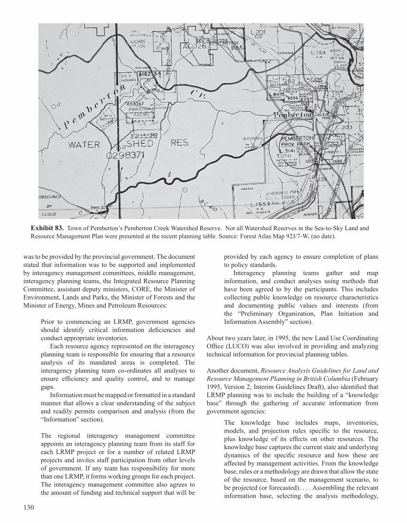
was to be provided by the provincial government. The document stated that information was to be supported and implemented by interagency management committees, middle management, interagency planning teams, the Integrated Resource Planning Committee, assistant deputy ministers, CORE, the Minister of Environment, Lands and Parks, the Minister of Forests and the Minister of Energy, Mines and Petroleum Resources:
Prior to commencing an LRMP, government agencies should identify critical information deficiencies and conduct appropriate inventories.
Each resource agency represented on the interagency planning team is responsible for ensuring that a resource analysis of its mandated areas is completed. The interagency planning team co-ordinates all analyses to ensure efficiency and quality control, and to manage gaps.
Information must be mapped or formatted in a standard manner that allows a clear understanding of the subject and readily permits comparison and analysis (from the “Information” section).
The regional interagency management committee appoints an interagency planning team from its staff for each LRMP project or for a number of related LRMP projects and invites staff participation from other levels of government. If any team has responsibility for more than one LRMP, it forms working groups for each project. The interagency management committee also agrees to the amount of funding and technical support that will be
provided by each agency to ensure completion of plans to policy standards.
Interagency planning teams gather and map information, and conduct analyses using methods that have been agreed to by the participants. This includes collecting public knowledge on resource characteristics and documenting public values and interests (from the “Preliminary Organization, Plan Initiation and Information Assembly” section).
About two years later, in 1995, the new Land Use Coordinating Office (LUCO) was also involved in providing and analyzing technical information for provincial planning tables.
Another document, Resource Analysis Guidelines for Land and Resource Management Planning in British Columbia (February 1995, Version 2, Interim Guidelines Draft), also identified that LRMP planning was to include the building of a “knowledge base” through the gathering of accurate information from government agencies:
The knowledge base includes maps, inventories, models, and projection rules specific to the resource, plus knowledge of its effects on other resources. The knowledge base captures the current state and underlying dynamics of the specific resource and how these are affected by management activities. From the knowledge base, rules or a methodology are drawn that allow the state of the resource, based on the management scenario, to be projected (or forecasted). . . . Assembling the relevant information base, selecting the analysis methodology,
Exhibit 83. Town of Pemberton’s Pemberton Creek Watershed Reserve. Not all Watershed Reserves in the Sea-to-Sky Land and Resource Management Plan were presented at the recent planning table. Source: Forest Atlas Map 92J/7-W, (no date).
130
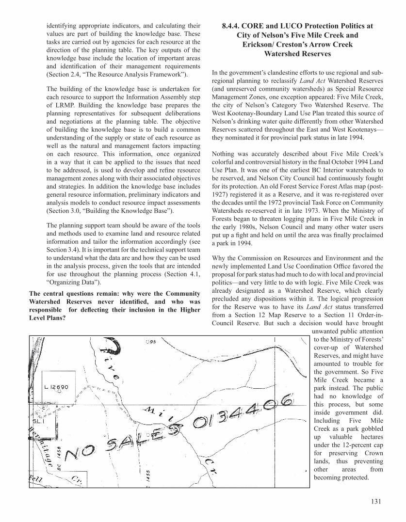
identifying appropriate indicators, and calculating their values are part of building the knowledge base. These tasks are carried out by agencies for each resource at the direction of the planning table. The key outputs of the knowledge base include the location of important areas and identification of their management requirements (Section 2.4, “The Resource Analysis Framework”).
The building of the knowledge base is undertaken for each resource to support the Information Assembly step of LRMP. Building the knowledge base prepares the planning representatives for subsequent deliberations and negotiations at the planning table. The objective of building the knowledge base is to build a common understanding of the supply or state of each resource as well as the natural and management factors impacting on each resource. This information, once organized in a way that it can be applied to the issues that need to be addressed, is used to develop and refine resource management zones along with their associated objectives and strategies. In addition the knowledge base includes general resource information, preliminary indicators and analysis models to conduct resource impact assessments (Section 3.0, “Building the Knowledge Base”).
The planning support team should be aware of the tools and methods used to examine land and resource related information and tailor the information accordingly (see Section 3.4). It is important for the technical support team to understand what the data are and how they can be used in the analysis process, given the tools that are intended for use throughout the planning process (Section 4.1, “Organizing Data”).
The central questions remain: why were the Community Watershed Reserves never identified, and who was responsible for deflecting their inclusion in the Higher Level Plans?
8.4.4. CORE and LUCO Protection Politics at City of Nelson’s Five Mile Creek and
Erickson/ Creston’s Arrow Creek Watershed Reserves
In the government’s clandestine efforts to use regional and sub-regional planning to reclassify Land Act Watershed Reserves (and unreserved community watersheds) as Special Resource Management Zones, one exception appeared: Five Mile Creek, the city of Nelson’s Category Two Watershed Reserve. The West Kootenay-Boundary Land Use Plan treated this source of Nelson’s drinking water quite differently from other Watershed Reserves scattered throughout the East and West Kootenays—they nominated it for provincial park status in late 1994.
Nothing was accurately described about Five Mile Creek’s colorful and controversial history in the final October 1994 Land Use Plan. It was one of the earliest BC Interior watersheds to be reserved, and Nelson City Council had continuously fought for its protection. An old Forest Service Forest Atlas map (post-1927) registered it as a Reserve, and it was re-registered over the decades until the 1972 provincial Task Force on Community Watersheds re-reserved it in late 1973. When the Ministry of Forests began to threaten logging plans in Five Mile Creek in the early 1980s, Nelson Council and many other water users put up a fight and held on until the area was finally proclaimed a park in 1994.
Why the Commission on Resources and Environment and the newly implemented Land Use Coordination Office favored the proposal for park status had much to do with local and provincial politics—and very little to do with logic. Five Mile Creek was already designated as a Watershed Reserve, which clearly precluded any dispositions within it. The logical progression for the Reserve was to have its Land Act status transferred from a Section 12 Map Reserve to a Section 11 Order-in-Council Reserve. But such a decision would have brought
unwanted public attention to the Ministry of Forests’ cover-up of Watershed Reserves, and might have amounted to trouble for the government. So Five Mile Creek became a park instead. The public had no knowledge of this process, but some inside government did. Including Five Mile Creek as a park gobbled up valuable hectares under the 12-percent cap for preserving Crown lands, thus preventing other areas from becoming protected.
131
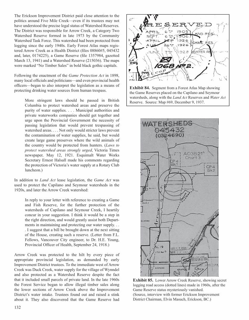
The Erickson Improvement District paid close attention to the politics around Five Mile Creek—even if its trustees may not have understood the precise legal status of Watershed Reserves. The District was responsible for Arrow Creek, a Category Two Watershed Reserve formed in late 1973 by the Community Watershed Task Force. This watershed had been protected from logging since the early 1940s. Early Forest Atlas maps regis-tered Arrow Creek as a Health District (files 08860#5, 045432 and, later, 0174225), a Game Reserve (file 1357984, gazetted March 13, 1941) and a Watershed Reserve (215036). The maps were marked “No Timber Sales” in bold black gothic capitals.
Following the enactment of the Game Protection Act in 1898, many local officials and politicians—and even provincial health officers—began to also interpret the legislation as a means of protecting drinking water sources from human trespass.
More stringent laws should be passed in British Columbia to protect watershed areas and preserve the purity of water supplies. . . . Municipal authorities and private waterworks companies should get together and urge upon the Provincial Government the necessity of passing legislation that would prevent trespassing of watershed areas. . . . Not only would stricter laws prevent the contamination of water supplies, he said, but would create large game preserves where the wild animals of the country would be protected from hunters. (Laws to protect watershed areas strongly urged, Victoria Times newspaper, May 12, 1921. Esquimalt Water Works Secretary Ernest Halsall made his comments regarding the protection of Victoria’s water supply at a Rotary Club luncheon.)
In addition to Land Act lease legislation, the Game Act was used to protect the Capilano and Seymour watersheds in the 1920s, and later the Arrow Creek watershed:
In reply to your letter with reference to creating a Game and Fish Reserve, for the further protection of the watersheds of Capilano and Seymour Creek, I heartily concur in your suggestion. I think it would be a step in the right direction, and would greatly assist both Depart-ments in maintaining and protecting our water supply. . . . I suggest that a bill be brought down at the next sitting of the House, creating such a reserve. (Letter from F.L. Fellows, Vancouver City engineer, to Dr. H.E. Young, Provincial Officer of Health, September 24, 1918.)
Arrow Creek was protected to the hilt by every piece of appropriate provincial legislation, as demanded by early Improvement District trustees. To the immediate west of Arrow Creek was Duck Creek, water supply for the village of Wynndel and also protected as a Watershed Reserve despite the fact that it included small parcels of private land. In the late 1960s the Forest Service began to allow illegal timber sales along the lower sections of Arrow Creek above the Improvement District’s water intake. Trustees found out and raised a stink about it. They also discovered that the Game Reserve had
Exhibit 84. Segment from a Forest Atlas Map showing the Game Reserves placed on the Capilano and Seymour watersheds, along with the Land Act Reserves and Water Act Reserve. Source: Map #69, December 9, 1937.
Exhibit 85. Lower Arrow Creek Reserve, showing secret logging road access (dotted lines) made in 1960s, after the Game Reserve status mysteriously vanished. (Source, interview with former Erickson Improvement District Chairman, Elvin Masuch, Erickson, BC.)
132
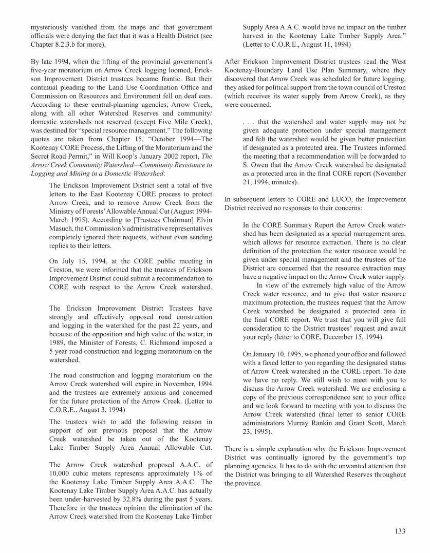
mysteriously vanished from the maps and that government officials were denying the fact that it was a Health District (see Chapter 8.2.3.b for more).
By late 1994, when the lifting of the provincial government’s five-year moratorium on Arrow Creek logging loomed, Erick-son Improvement District trustees became frantic. But their continual pleading to the Land Use Coordination Office and Commission on Resources and Environment fell on deaf ears. According to these central-planning agencies, Arrow Creek, along with all other Watershed Reserves and community/domestic watersheds not reserved (except Five Mile Creek), was destined for “special resource management.” The following quotes are taken from Chapter 15, “October 1994—The Kootenay CORE Process, the Lifting of the Moratorium and the Secret Road Permit,” in Will Koop’s January 2002 report, The Arrow Creek Community Watershed—Community Resistance to Logging and Mining in a Domestic Watershed:
The Erickson Improvement District sent a total of five letters to the East Kootenay CORE process to protect Arrow Creek, and to remove Arrow Creek from the Ministry of Forests’ Allowable Annual Cut (August 1994-March 1995). According to [Trustees Chairman] Elvin Masuch, the Commission’s administrative representatives completely ignored their requests, without even sending replies to their letters.
On July 15, 1994, at the CORE public meeting in Creston, we were informed that the trustees of Erickson Improvement District could submit a recommendation to CORE with respect to the Arrow Creek watershed.
The Erickson Improvement District Trustees have strongly and effectively opposed road construction and logging in the watershed for the past 22 years, and because of the opposition and high value of the water, in 1989, the Minister of Forests, C. Richmond imposed a 5 year road construction and logging moratorium on the watershed.
The road construction and logging moratorium on the Arrow Creek watershed will expire in November, 1994 and the trustees are extremely anxious and concerned for the future protection of the Arrow Creek. (Letter to C.O.R.E., August 3, 1994)
The trustees wish to add the following reason in support of our previous proposal that the Arrow Creek watershed be taken out of the Kootenay Lake Timber Supply Area Annual Allowable Cut.
The Arrow Creek watershed proposed A.A.C. of 10,000 cubic meters represents approximately 1% of the Kootenay Lake Timber Supply Area A.A.C. The Kootenay Lake Timber Supply Area A.A.C. has actually been under-harvested by 32.8% during the past 5 years. Therefore in the trustees opinion the elimination of the Arrow Creek watershed from the Kootenay Lake Timber
Supply Area A.A.C. would have no impact on the timber harvest in the Kootenay Lake Timber Supply Area.” (Letter to C.O.R.E., August 11, 1994)
After Erickson Improvement District trustees read the West Kootenay-Boundary Land Use Plan Summary, where they discovered that Arrow Creek was scheduled for future logging, they asked for political support from the town council of Creston (which receives its water supply from Arrow Creek), as they were concerned:
. . . that the watershed and water supply may not be given adequate protection under special management and felt the watershed would be given better protection if designated as a protected area. The Trustees informed the meeting that a recommendation will be forwarded to S. Owen that the Arrow Creek watershed be designated as a protected area in the final CORE report (November 21, 1994, minutes).
In subsequent letters to CORE and LUCO, the Improvement District received no responses to their concerns:
In the CORE Summary Report the Arrow Creek water-shed has been designated as a special management area, which allows for resource extraction. There is no clear definition of the protection the water resource would be given under special management and the trustees of the District are concerned that the resource extraction may have a negative impact on the Arrow Creek water supply. In view of the extremely high value of the Arrow Creek water resource, and to give that water resource maximum protection, the trustees request that the Arrow Creek watershed be designated a protected area in the final CORE report. We trust that you will give full consideration to the District trustees’ request and await your reply (letter to CORE, December 15, 1994).
On January 10, 1995, we phoned your office and followed with a faxed letter to you regarding the designated status of Arrow Creek watershed in the CORE report. To date we have no reply. We still wish to meet with you to discuss the Arrow Creek watershed. We are enclosing a copy of the previous correspondence sent to your office and we look forward to meeting with you to discuss the Arrow Creek watershed (final letter to senior CORE administrators Murray Rankin and Grant Scott, March 23, 1995).
There is a simple explanation why the Erickson Improvement District was continually ignored by the government’s top planning agencies. It has to do with the unwanted attention that the District was bringing to all Watershed Reserves throughout the province.
133
A bitter deluge of complaints by BC water users in the late 1980s provoked intense discussions at the annual conferences of the Union of BC Municipalities, and the Union passed a number of resolutions to protect groundwater sources and public drinking watersheds on Crown and private lands. The Social Credit government became sufficiently concerned (again) that it formed an inter-governmental committee to conduct follow-up investigations and a general review. The Inter-Agency Community Watersheds Management Committee began to meet in earnest in early 1990 and broke up in late 1991. In the end, nothing was resolved regarding the concerns brought forward by the Union of BC Municipalities.
In March 1990, the Ministry of Environment provided a four-page, draft terms of reference for the committee, Provincial Guidelines for Integrated Community Watershed Management. Its purpose was to “update, revise and expand the 1980 docu-ment entitled Guidelines for Watershed Management of Crown Lands Used as Community Water Supplies.” In a section called “Major Tasks,” recommendations were included to:
. . . update Appendix G List of Community Watersheds [the Land Act Watershed Reserves]; review all existing, new and proposed legislation (i.e. Environmental Management Act, Water Act) mandates, policies, programs, regulations, standards, controls and guidelines of Ministries involved in the management of land/re-source activities in community watersheds; and to clarify and outline administrative procedures for Crown Lands referral system and use of map reserves and notations (emphasis added).
This document is intriguing in that formal government references to Watershed Reserves were rare indeed by this time. Also interesting was the reference to Appendix G.
With the defeat of Social Credit in the October 17, 1991, election, the New Democratic administration formed another multi-agency community watershed committee, the Technical Advisory Committee, which met in 1992 and 1993. Nothing was resolved there, either, but the new government did achieve some quite insidious accomplishments through this committee. The Technical Advisory Committee “was formed to develop new guidelines for protecting drinking water in community watersheds from the impacts of multiple resource use—logging, road building, recreation, agriculture, etc” (Community
Watershed Guidelines, fourth draft, August 2, 1994, page 1-1). It met about 30 times over the course of two years and also held a series of eight or so public meetings across BC in early 1993, when the Land Use Plans were underway. The Land Act Watershed Reserves, however, were not mentioned at all during these meetings. Government simply wanted them to vanish and the public to forget about them.
A Community Watershed Guidelines Committee was created through the Technical Advisory Committee and prepared a series of four draft reports, which circulated among govern-ment staff in 1993 and 1994. In this latest committee’s 220-page fourth draft report, Community Watershed Guidelines (August 4, 1994), it was stated that these new guidelines were to replace the October 1980 Ministry of Environment Guidelines specifically created for Watershed Reserves. However, there was no reference to Watershed Reserves anywhere in the August 1994 Guidelines. The substance of the final draft was boiled down and incorporated into a 120-page October 1996 Community Watershed Guidelines Guidebook under the new Forest Practices Code Act legislation. Once again there was no reference to Watershed Reserves. Although the two government committees did discuss the prospect of replacing the Ministry of Environment’s 1980 Guidelines for Watershed Reserves, the earlier document was never formally rescinded, just pushed to the side as government agencies conducted their own interpretive planning for reserves and unreserved community watersheds.
In preparation for the proposed Forest Practices Code Act, the Community Watershed Guidelines Committee established a new classification system for the provincial community watersheds. It assigned them a numeric code, surreptitiously merging Land Act Watershed Reserves with unreserved community watersheds. When they were created, all Land Act Reserves had already been provided with numeric codes, which were cross-referenced to Lands ministry files and recorded on BC Lands’ Legal Survey maps. This provision was recognized in the 1993 protocol agreement (see Chapter 8.3.2.), where Land Act Reserves were declared to be under the “administration” of BC Lands. This latest deception was necessary because government now wanted it to appear that all 676 community watersheds identified in the August 1994 draft Community Watershed Guidelines (see Appendix 1 of the draft, “List of Community Watersheds in British Columbia”) were under the authority of the Forest Practices Code Act.
The list of 676 community watersheds in Appendix 1 provided information on Ministry of Forests Region and District, newly assigned code number, name of watershed, area of watershed, GIS map number, water licensee, water licence date and name of ecoregion. No separate column, however, was provided to confirm which watersheds were designated as Reserves. In fact, the 16-page glossary made no reference to Reserves, even under the definition of “protected areas.” The entire Guidelines document was a complete whitewash. Except for a handful of Sunshine Coast activists and a few scattered
8.4.5. The Community Watershed Guidelines Committee and the Forest Practices Code Act
“In preparation for the proposed Forest Practices Code Act, the Community Watershed Guidelines Committee established a new classification system for the provincial community watersheds. It assigned them a new numeric code, surreptitiously merging Land Act Watershed Reserves with unreserved community watersheds.”
134
others, the public was completely fooled by this government maneuver.
The August 1994 Guidelines draft provided an interpretation of how provincial “community watersheds,” as opposed to “domestic watersheds,” should be defined and integrated by the new Land and Resource Management Plans (LRMPs). Community watersheds were to be designated as “landscape units” under new “strategic planning regulations,” the objectives of which were to be “consistent with the guiding principles, standards and guidelines for community watersheds as established under the [proposed] Forest Practices Code.” For each landscape unit the Ministry of Forests and Ministry of Environment, Lands and Parks were to coordinate a “total resource plan,” which the Guidelines defined as a “map-based planning process that designates sensitive and protected areas and designs appropriate long-term resource development within a watershed.” The Forests and Environment ministries’ Total Resource Planning Committee was developing the total resource plans at this time. As explained in the Guidelines, Total Resource Plans were to be conducted within “community watersheds” and could include road construction, logging, cattle grazing, mining, recreation, residential development, utility corridors and chemical applications.
The August 1994 Guidelines draft did offer some interesting statistics about the 676 community watersheds (though statistics on Greater Vancouver and Greater Victoria’s drinking water-sheds were inexplicably excluded). These are presented here (Exhibit 86) from Table 2.1, “Summary of Community
Watersheds in BC,” and Table 2.2, “Drainage Areas of Community Watersheds in BC.” The list of community watersheds in Appendix 1 of the August 1994 Guidelines is reproduced in Appendix H of this report.
“The Forest Practices Code, which applies to the vast majority of community watersheds, provides significant protection to watersheds. At the present time there are 675 community watersheds on Crown land that come under the Forest Practices Code. The Ministry of Environment, Lands and Parks is working closely with the Ministry of Forests and Forest Renewal BC in prescribing acceptable forestry practices, setting water quality objectives and monitoring water quality within these watersheds. The Community Watershed Guidebook, published in October 1996 by the Ministry of Forests, provides detailed guidance on how forestry activities, including rangeland activities, are to be carried out in community watersheds.”
Cathy McGregor, Minister of Environment, Lands and Parks,
to Will Koop, Coordinator,B.C. Tap Water Alliance, April 29, 1997.
TYPE Creek/River Lake Spring Swamp TOTALMunicipal and Other Waterworks 445 52 82 1 580Water Users’ Communities 68 4 23 1 96TOTAL 513 56 105 2 676
Community Watershed Drainage
Area (sq.km)
Number of Watersheds Percentage of Total
Cumulative Percentage
Less than 1 120 21 21.11-2 67 11.7 32.82-3 34 5.9 38.73-5 54 9.5 48.25-10 83 14.5 62.710-50 126 22.1 84.850-100 36 6.3 91.1
More than 100 50 8.8 100
Exhibit 86. Tables 2.1 (above) and 2.2 (below) with statistics on BC’s community watersheds (excluding “domestic” watersheds), from the Ministry of Environment’s Community Watershed Guidelines (4th Draft, August 2, 1994). The definition of a “domestic” watershed, in comparision to a “community” watershed, is based on a fewer number of water users for a given watershed. For information and definitions on the domestic watersheds, see the Domestic Watershed Committee’s April 21, 1997 internal report, Managing Domestic Watersheds in British Columbia. Final Report: Issues and Recommendations.
135
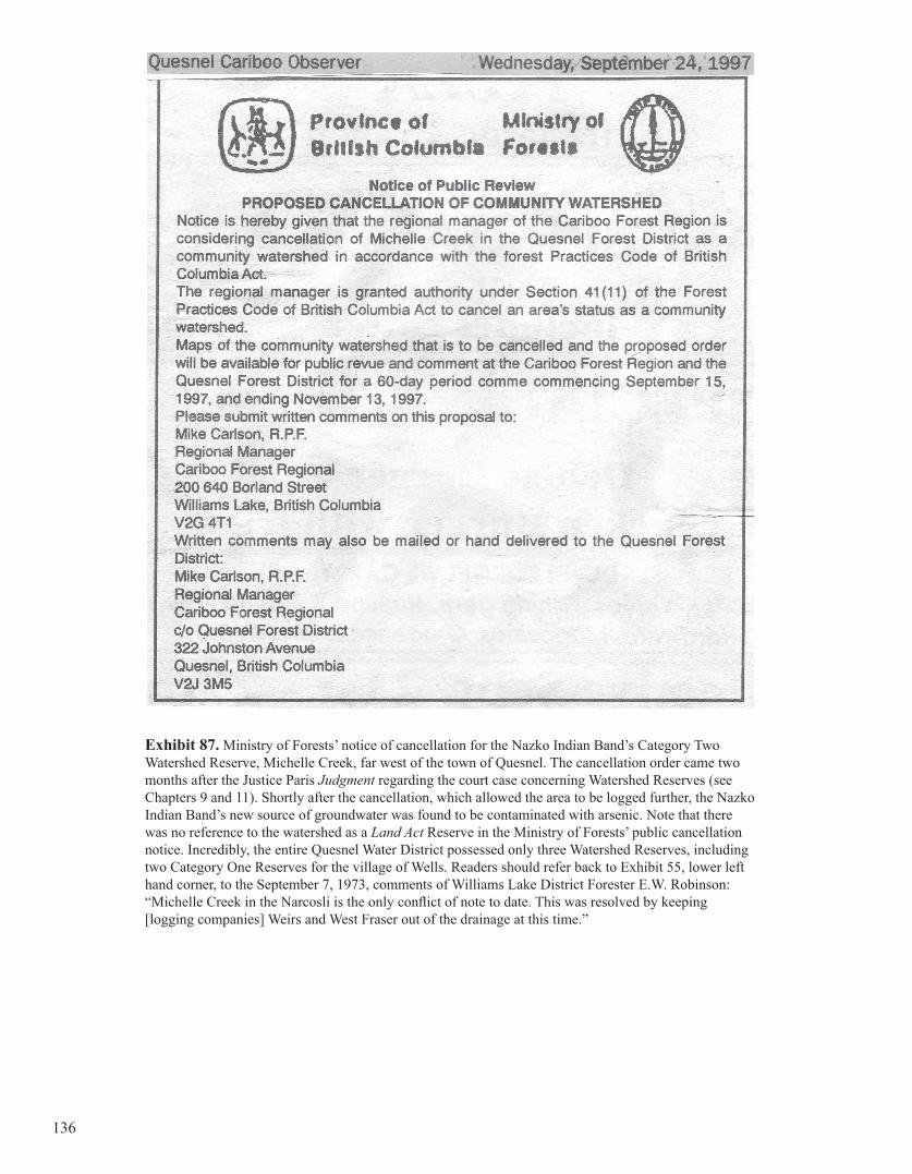
Exhibit 87. Ministry of Forests’ notice of cancellation for the Nazko Indian Band’s Category Two Watershed Reserve, Michelle Creek, far west of the town of Quesnel. The cancellation order came two months after the Justice Paris Judgment regarding the court case concerning Watershed Reserves (see Chapters 9 and 11). Shortly after the cancellation, which allowed the area to be logged further, the Nazko Indian Band’s new source of groundwater was found to be contaminated with arsenic. Note that there was no reference to the watershed as a Land Act Reserve in the Ministry of Forests’ public cancellation notice. Incredibly, the entire Quesnel Water District possessed only three Watershed Reserves, including two Category One Reserves for the village of Wells. Readers should refer back to Exhibit 55, lower left hand corner, to the September 7, 1973, comments of Williams Lake District Forester E.W. Robinson: “Michelle Creek in the Narcosli is the only conflict of note to date. This was resolved by keeping [logging companies] Weirs and West Fraser out of the drainage at this time.”
136

Exhibit #4 – Copy of the Executive Summary, in Will Koop’s June 2006 book, From Wisdom
to Tyranny: A History of British Columbia’s Drinking Watershed Reserves.
From Wisdom to Tyranny
A History of British Columbia’s Drinking Watershed Reserves
By Will Koop, B.C. Tap Water Alliance,May 21, 2006.
(Website: www.bctwa.org)
EXECUTIVE SUMMARY - FINDINGS AND RECOMMENDATIONS
From Wisdom to Tyranny is a long, factual investigative report about British Columbia’s (BC’s) Watershed Reserves. It is based on information accumulated over a period of about ten years from numerous sources, including two large and intriguing government files. The Reserves, created under the provincial Land Act, were public lands specifically set aside and protected as community drinking and domestic water sources. Early Forest Atlas maps—the central information reference for all Forest Service activities—displayed, in large letters, a standard disclaimer over these drinking watershed sources: NO TIMBER SALES. The protection of the public’s drinking water was obligatory, a fiduciary responsibility—what the Chief Forester’s office reluctantly understood as a “moral obligation” and described as such to administrative foresters (L.F. Swannell, Assistant Chief Forester, December 29, 1960).
The report details a turf war over BC’s drinking watersheds, pitting the Forest Service and its private industry clients against the province’s water users, and involving various elaborate cover-ups of the truth about Watershed Reserves. The government’s most scandalous behavior erupted in late 1980, following the end of a nine-year Task Force investigation into public drinking water sources. A succession of conniving public administrators—primarily government foresters and forest advisors—conspired to devise elaborate, wholesale deceptions in order to allow industrial resource users to operate at a profit in areas that were previously off-limits and protected as Watershed Reserves, all at the long-term expense of community water users.
The creation of BC’s Watershed Reserves by concerned water users and politicians began about 100 years ago. The Reserves were administered through provincial and federal Crown land legislation that protected public drinking water sources, mainly from commercial logging and public trespass. As BC’s population increased and industry expanded following World War II, other threats to water sources emerged: cattle grazing, mineral exploration, hydroelectric and other utility corridors, road access, recreation, etc. Evidence presented in 1944 and 1945 at BC’s second Royal Commission on Forest Resources described many Reserves throughout the province and noted that BC’s water users wanted the provincial government to continue applying this form of protection. The evidence also revealed that in the Okanagan Valley area the Forest Service was secretly ignoring legislation that protected the Reserves, abandoning its formal referral responsibilities to water users. However, later provincial Royal Commissions (in 1956 and 1976) and the Forest Resources Commission (in 1991) mysteriously failed to mention anything about Watershed Reserves, despite the fact that a provincial Task Force (1972-1980) had created and re-created about 300 of them under the protective powers of the Land Act. The BC Lands Ministry continued to create Watershed Reserves until the late 1980s, at which time the Social Credit government, heavily influenced by resource industry titans, began to uniformly ignore these preserves.
Government foresters, in alliance with industry and academic foresters—a coalition described in this report as the “Timber Triangle”—began to systematically oppose and stymie the Land Act legislation from the 1960s onward, lobbying provincial and local governments to allow logging in Watershed Reserves. Though only briefly summarized
7
in this report, the crusade against the protection of the public’s drinking watersheds actually originated in the United States (US) in the 1940s. The Washington forest industry reinforced its incursions into Seattle’s Cedar River drinking watershed with an extensive public-relations program in support of such activities, a program that quickly spread to BC with the help of industry associates and government foresters.
In July 1946, a US Forest Service forester, George A. Duthie, announced to municipal drinking water engineers affiliated with the American Water Works Association (see the article Should Your City Have a Municipal Forest, in the AWWA Journal) that thousands of protected community watersheds in the US should sacrifice their collective timber holdings for the common good of the forest industry. The rationale espoused by Duthie, and others like him, also helped introduce timber harvesting to BC’s drinking watersheds. A policy of “single use” of such watersheds (for water production only) had long dominated both governmental and public thinking. The forest industry, however, considered “single use” a threat and an irritant, and gradually insinuated an alternative model, one of “multiple use”—later polished under the banner of “integrated resource management”—thus eroding and, eventually, eradicating the protected status of municipal and community drinking water sources.
The manner in which the Timber Triangle initially instituted these changes was by compromising protective drinking watershed legislation and policies in the largest population centers. In BC this meant the watersheds of the Greater Victoria and Greater Vancouver Regional Districts. In the northwest US, Seattle’s Water Department and the Portland Water Bureau were targeted. The Triangle’s endeavors were tenacious and insidious; the battle was for total control. Later efforts in BC focused on the city of Nelson’s community drinking watershed (Five Mile Creek, vigilantly protected as a Watershed Reserve since 1939), where secret plans to log and construct roads were designed to become important precedents for harvesting in the region’s remaining domestic watersheds. Although the Five Mile Creek Reserve was eventually protected as a provincial park in 1994, the Ministry of Forests was not prevented—despite persistent opposition by local water users and community activists—from going ahead with its plans. Today, as a result, drinking water sources are jeopardized throughout the Nelson Forest Region and—more ominously—public opposition to ministry activity is sadly fragmented and divided.
FINDINGS
This report makes a series of intriguing and disturbing findings about Watershed Reserves—and about the effects that the actions of the BC government, primarily through the Forest Service, have had on them. These findings are summarized, chronologically, in the following 18 points:
1. The resolution passed by professional foresters and engineers at a February 1952 BC Natural Resources conference, calling for forest harvesting in BC’s protected drinking watersheds, heralded a new era for sustained-yield logging throughout the province. The announcement of the resolution coincided with proposed sustained-yield logging in Greater Victoria’s watersheds, the first such program in Canadian history (Chapter 3).
2. The Social Credit government amended a critical section of the Forest Act in 1960 (the first such change since the legislation was created in 1912) to exempt newly allocated and future Tree Farm Licensees from policies that provided protection to public drinking watersheds within their permit boundaries. This contradicted government policy on the protection of drinking water sources (Chapter 3).
3. A December 1960 internal memo from Assistant Chief Forester Swannell to his provincial foresters detailed how they should overturn and deflect policies that protected Land Act Reserves and watersheds not reserved (Chapter 7.2).
4. In 1967, a government forester advised the alteration of the Lands department’s policy for the protection of forests in Watershed Reserves, a policy that had been in place for decades (Chapter 7.3).
8
5. Public Sustained Yield Unit planning committees throughout BC were directed to begin logging in community and domestic watersheds and to include these previously off-limit areas in the timber harvesting land base. This went against specific recommendations in Forest Service manuals to keep the drinking watersheds out of proposed Allowable Annual Cut determinations (Chapter 9.3.6).
6. The revision of the Land Act in 1970 by the Social Credit government included the removal of the 999-year lease condition for Crown lands, originally introduced in 1908 specifically to protect drinking watersheds (Chapter 1.2).
7. In the early to mid-1970s a number of Forest Service regions blatantly rebelled against specific ministerial orders, made through a cabinet committee to a provincial Task Force on Community Watersheds, to re-cognize newly created and re-created Watershed Reserves on the Forest Service’s Forest Atlas maps (the central reference tools for all forest license permitting). During this period the Forest Service illegally allowed logging and granted road permits in an unknown number of Watershed Reserves (Chapter 7).
8. After the Forest Service was removed from the broad overview of the Ministry of Lands, Forests and Water Resources in 1976 and established as the stand-alone Ministry of Forests, the service began to single-handedly override policies designed to protect the public’s drinking watersheds (Chapters 7.8, 8, 9.3.2 and 9.3.3).
9. The substantial revision of the Forest Act in 1978 included the removal of the 66-year-old provision that specified how the public’s drinking watersheds were to be protected in Provincial Forests (formerly called Forest Reserves) under the Land Act (Chapter 9.3.10).
10. The manipulative reinterpretation of drinking watershed and Watershed Reserve policies by Ministry of Forests planners in 1981 and 1982—and the corruption of Ministry of Environment directives to adhere to such policies—conformed to a new internal policy of “integrated resource management” (Chapter 8.1.2 and following).
11. The Ministry of Crown Lands was removed from all Land Act Watershed Reserve referrals (Chapters 7.7 and 8.3).
12. The newly created Ministry of Forests attempted but failed to take control of the responsibilities of the ministries of Health and Environment as Lead Agency over the Watershed Reserves and drinking watersheds not reserved (Chapter 8.1).
13. The Ministry of Forests secretly railroaded a 1978 recommendation from the provincial Task Force on Community Watersheds to the Deputy Minister’s Environment and Technical Land Use Committee to permanently protect about 150 Watershed Reserves as Section 11 Land Act Order-in-Council Reserves. This legislation would have given the watersheds the same level of finalized protection as provincial parks, creating a powerful precedent and example for the stewardship of drinking water sources. Eventually, all these Reserves were wrongfully included in the timber harvesting land base (Chapter 5).
14. In 1984, the Ministry of Forests and the Ministry of Environment began the first formal public planning processes for provincial Watershed Reserves, known as Integrated Watershed Management Plans (IWMPs). Government records indicate that the Ministry of Forests planned to use the IWMPs as a tool to force provincial water users to accept multiple forms of resource use in their protected watersheds. Water users rejected this assault. During these planning processes in the 1980s and early 1990s, the government failed to provide any information to BC’s water users about the Watershed Reserves and their legislative significance (Chapter 8.2).
9
15. After 1986, when the stand-alone Ministry of Forests absorbed the functions of the Lands Ministry to become the Ministry of Forests and Lands, it quietly began to STRIP a large number of the Community
Watersheds of their Reserve status, thereby DEMOTING them to their original Notations of Interest (under the Land Act), a non-protective designation (Chapter 11.3).
16. When the Social Credit government was replaced by the New Democrat administration (1991), a new “public participation” era in land use planning was legislated under the Commission on Resources and Environment (CORE). Three Regional Land Use Plans were completed by the mid-1990s, and numerous sub-regional planning processes (known as Land and Resource Management Plans or LRMPs) took place and continued up until the present time. During these planning processes government failed to inform the public about Watershed Reserves, despite the fact that they were officially registered on Legal Survey and Forest Atlas maps. These processes, insofar as they relate to Watershed Reserves, were thus conducted illegally, as they ignored the legislative status of Land Act Reserves (Chapter 8.4).
17. From 1993 to 1995, an internal government committee on drinking watersheds re-classified hundreds of Land Act Watershed Reserves, along with drinking watersheds not reserved, into one group, known as Forest Practices Code Act Community Watersheds. The Reserves, which already had their own file codes under the Lands Ministry, were given separate file numbers associated with the new Forest Practices Code Act. There was not one reference to Watershed Reserves in either the 1995 Forest Practices Code Act or the 1996 Forest Practices Code Guidelines Manual. There was no mention of the significance of Watershed Reserves under Land Act legislation as areas that precluded provincial resource permitting. Watershed Reserves were made invisible. It was as if they had never existed, proof that if you ignore something intently enough it can be made to disappear—and others can be made to believe that it has disappeared—even though it is right in front of everyone’s eyes. There may be sufficient grounds to legally challenge the Forest Practices Code Act for purposely ignoring Watershed Reserves (Chapters 8.4.5 and 11.2).
18. The Valhalla Wilderness Society took the government to the BC Supreme Court in June 1997 over two Watershed Reserves in the Slocan Valley near the town of Silverton. It was the first trial in BC’s history regarding a Watershed Reserve. The government misled the court by stating that the two Reserves in question were not Reserves under the Land Act and that the Ministry of Forests had the right to issue road and logging permits there. Unfortunately Justice Paris sided with the government and ruled that the permits were legal. This report includes a comprehensive rebuttal of Justice Paris’s July 8, 1997, Judgment and an exposure of the scandal behind the trial (Chapter 9.3). Subsequent to the trial, the Ministry of Forests and the Ministry of Environment, Lands and Parks (superseded in 2001 by the ministries of Water, Land and Air Protection and Sustainable Resource Management) contravened government policy by using Justice Paris’ Judgment as a legal precedent to approve multi-resource use in Watershed Reserves.
A serious question arises from the court case (discussed at length in Chapter 9). Why did the respondents—the Attorney General’s Department, the Ministry of Forests, the former Ministry of Environment, Lands and Parks and forest giant Slocan Forest Products—conspire to deliberately mislead the court and commit possible perjury about two small, almost insignificant Watershed Reserves? The answers have a lot to do with what led up to that moment in history (described for the most part in Chapter 8), and concern the corruption of public resource administration in BC over almost two decades. Ultimately, this subject is not confined to within the borders of BC but is inextricably linked to the convoluted resource politics of the United States.
As a result, the public’s water supplies (hundreds of sources in BC, thousands in the US) were degraded, sometimes severely. Water sources were polluted and expensive water treatments required, paid for by tax dollars. The degradation of the watersheds, never accurately reported on before, has provoked continued public resistance and criticism, and an overwhelming lack of confidence by citizens in their own drinking water sources. 10
RECOMMENDATIONS
Despite the gloomy, tragic history of BC’s Watershed Reserves, it remains the Tap Water Alliance’s sincerest hope that British Columbians will benefit from the information presented in this report. Aside from what the government and the courts have tried to tell the public, there is overwhelming evidence that citizens do in fact have a legislative right to the full protection of their drinking water sources, as demonstrated by early provincial legislation and a long legacy of “single use.” This fact is not apparent, however, because the issue has been purposely clouded by a government in bed far too long with “vested interests.” Instead of being accountable to its own citizens and protecting their drinking water, BC’s government has indoctrinated and misled local administrators and the public for decades about the (unsuitable) benefits of “multiple use” and “integrated resource management.” Government has acted in bad faith to its electorate and has abused the public’s trust.
The following are our primary recommendations (restated verbatim from the report’s conclusion):
• That the contents of this report are a primary and sufficient catalyst for a provincial investigation into the actions of BC’s government regarding the Land Act Watershed Reserves, and those drinking watersheds not reserved;
• That an independent body of examiners conduct a forensic audit of all Crown land provincial planning initiatives and government records concerning the public’s Watershed Reserves and watersheds not reserved;
• That all licensed and tenured activities approved by the provincial government within Watershed Reserves be halted, pending a formal investigation;
• That this report serve as substantive grounds for water users to seek protection of their water sources through stronger legislation;
• That this report aid those BC water users with existing Watershed Reserves by helping them understand that they already have legal rights and avenues of protection over their water sources (despite what some government representatives have knowingly and mistakenly informed them over the years);
• That there are sufficient legal grounds to revisit, appeal and revoke BC Supreme Court Justice Paris’s July 8, 1997, Reasons for Judgment, and to investigate the corresponding government information and memos related to the court decision.
11