Embed Size (px)
Citation preview

Autonomous Mobile Robot Design
Dr. Kostas Alexis (CSE)
Sampling-based Aerial Robotic Inspection & Exploration Planning – A Primer
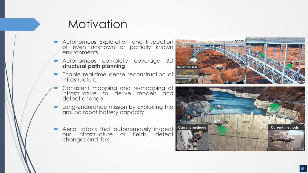
Motivation
Autonomous Exploration and Inspectionof even unknown or partially knownenvironments.
Autonomous complete coverage 3Dstructural path planning
Enable real-time dense reconstruction ofinfrastructure
Consistent mapping and re-mapping ofinfrastructure to derive models anddetect change
Long-endurance mission by exploiting theground robot battery capacity
Aerial robots that autonomously inspectour infrastructure or fields, detectchanges and risks.
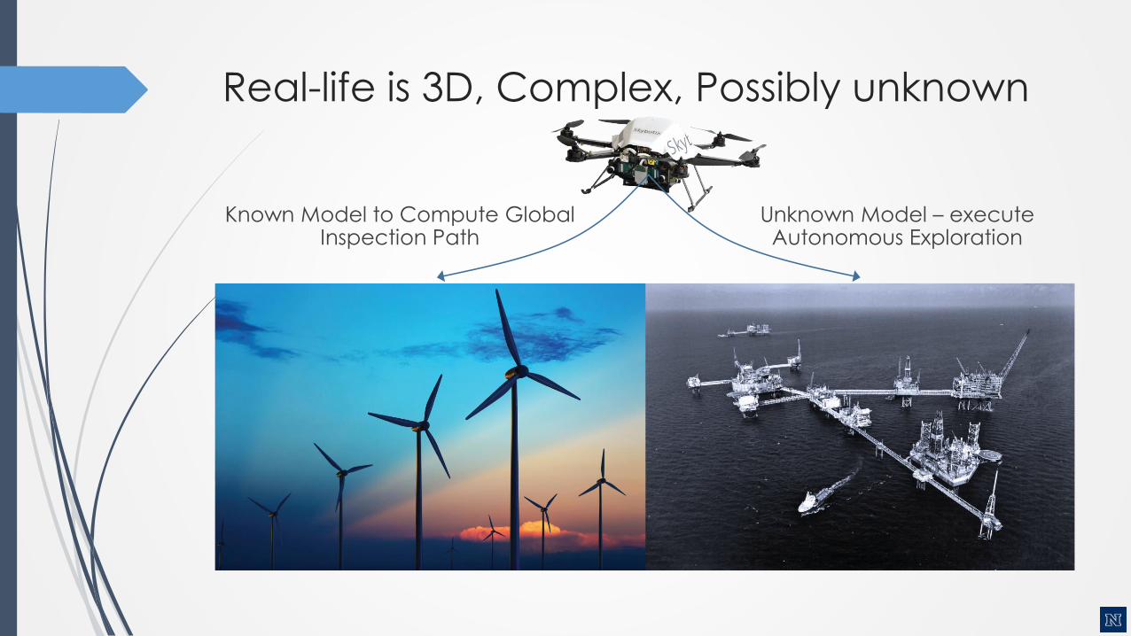
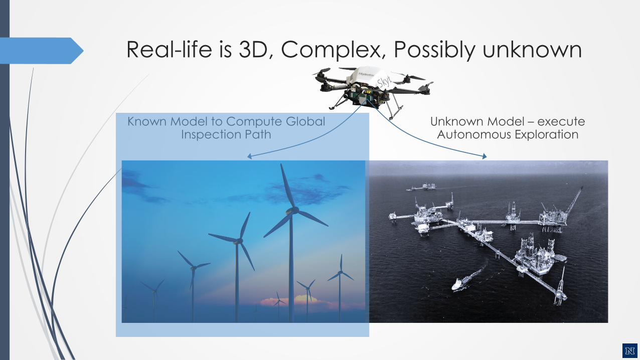
Real-life is 3D, Complex, Possibly unknown
Known Model to Compute Global Inspection Path
Unknown Model – execute Autonomous Exploration
Real-life is 3D, Complex, Possibly unknown
Known Model to Compute Global Inspection Path
Unknown Model – execute Autonomous Exploration
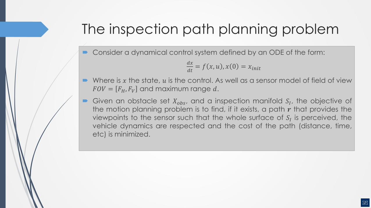
The inspection path planning problem
Consider a dynamical control system defined by an ODE of the form:
𝑑𝑥
𝑑𝑡= 𝑓 𝑥, 𝑢 , 𝑥 0 = 𝑥𝑖𝑛𝑖𝑡
Where is 𝑥 the state, 𝑢 is the control. As well as a sensor model of field of view
𝐹𝑂𝑉 = 𝐹𝐻, 𝐹𝑉 and maximum range 𝑑.
Given an obstacle set 𝑋𝑜𝑏𝑠, and a inspection manifold 𝑆𝐼, the objective of
the motion planning problem is to find, if it exists, a path 𝒓 that provides the
viewpoints to the sensor such that the whole surface of 𝑆𝐼 is perceived, the
vehicle dynamics are respected and the cost of the path (distance, time,
etc) is minimized.
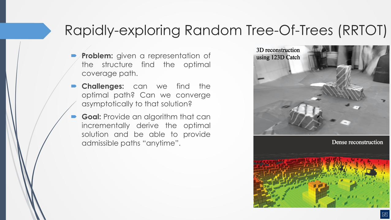
Rapidly-exploring Random Tree-Of-Trees (RRTOT)
Problem: given a representation of
the structure find the optimal
coverage path.
Challenges: can we find the
optimal path? Can we converge
asymptotically to that solution?
Goal: Provide an algorithm that canincrementally derive the optimal
solution and be able to provide
admissible paths “anytime”.
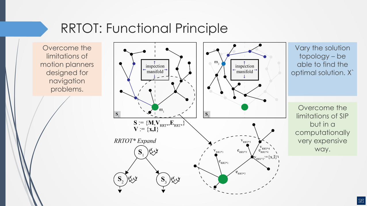
RRTOT: Functional Principle
Overcome the
limitations of
motion planners
designed for
navigation
problems.
Vary the solution
topology – be
able to find the
optimal solution. X`
Overcome the
limitations of SIP
but in a
computationally
very expensive
way.
RRTOT: Functional Principle
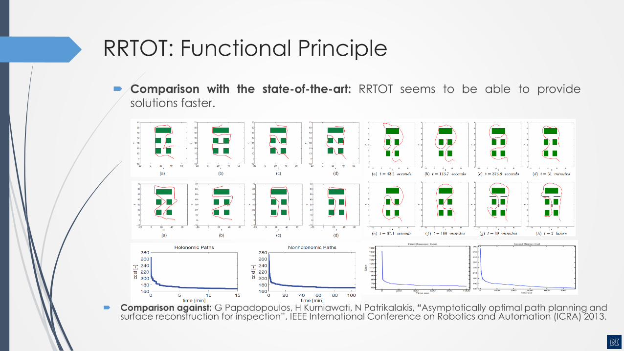
Comparison with the state-of-the-art: RRTOT seems to be able to provide
solutions faster.
Comparison against: G Papadopoulos, H Kurniawati, N Patrikalakis, “Asymptotically optimal path planning and surface reconstruction for inspection”, IEEE International Conference on Robotics and Automation (ICRA) 2013.
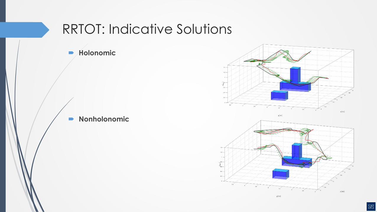
RRTOT: Indicative Solutions
Holonomic
Nonholonomic

RRTOT: Indicative Solutions
Kostas Alexis, Robotics Short Seminars, Feb 11 2016
Holonomic
Nonholonomic

Benefits and Disadvantages
Quality of the Solution: Proven to
provide asymptotically optimal
solution.
Complexity: Practically intractable
for large scale problems
Purpose: More of a “theoreticaltool” to compare other algorithms.
Alternative Solution
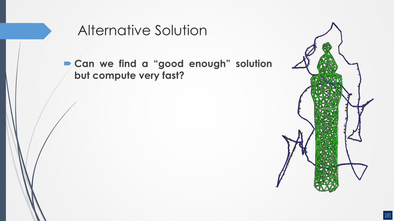
Can we find a “good enough” solution
but compute very fast?
Basic Concepts of the Inspection Planner
Main classes of existing 3D methods:
Separated Approach (AGP + TSP or
Control)
Prone to be suboptimal
In specific cases lead to infeasible paths(nonholonomic vehicles)
First attempts for optimal solutions via a
unified cycle
In specific cases can lead to theoptimal solution
Very high CPU and MemoryRequirements & Time
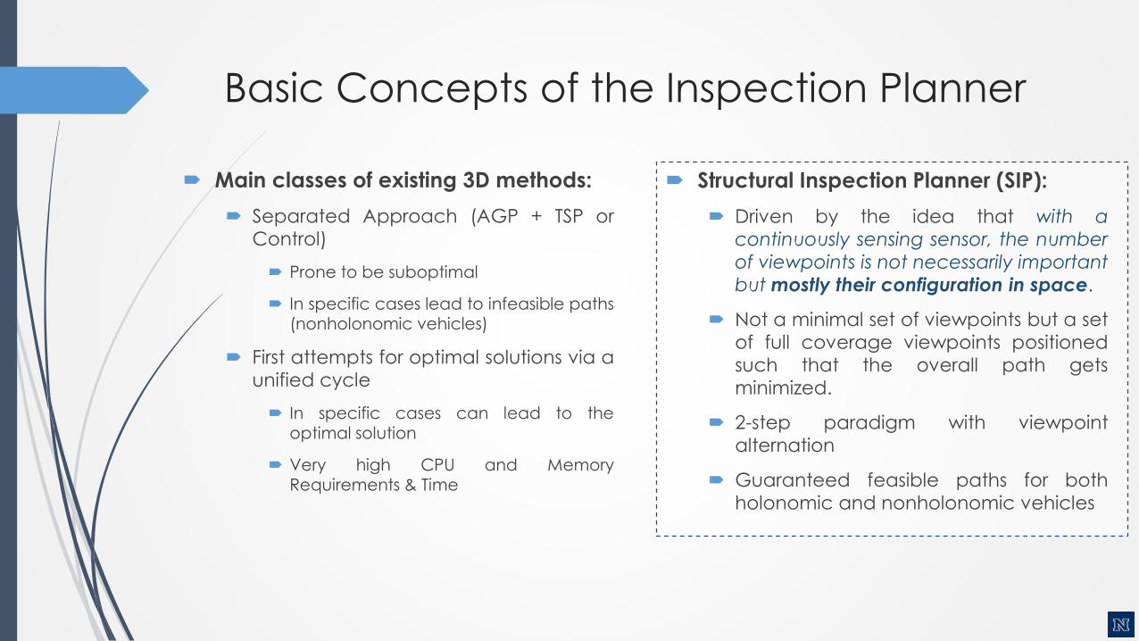
Structural Inspection Planner (SIP):
Driven by the idea that with a
continuously sensing sensor, the number
of viewpoints is not necessarily important
but mostly their configuration in space.
Not a minimal set of viewpoints but a set
of full coverage viewpoints positioned
such that the overall path gets
minimized.
2-step paradigm with viewpoint
alternation
Guaranteed feasible paths for both
holonomic and nonholonomic vehicles
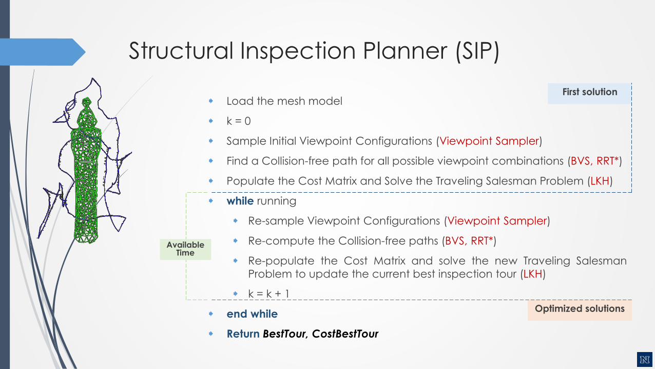
First solution
Structural Inspection Planner (SIP)
Load the mesh model
k = 0
Sample Initial Viewpoint Configurations (Viewpoint Sampler)
Find a Collision-free path for all possible viewpoint combinations (BVS, RRT*)
Populate the Cost Matrix and Solve the Traveling Salesman Problem (LKH)
while running
Re-sample Viewpoint Configurations (Viewpoint Sampler)
Re-compute the Collision-free paths (BVS, RRT*)
Re-populate the Cost Matrix and solve the new Traveling Salesman
Problem to update the current best inspection tour (LKH)
k = k + 1
end while
Return BestTour, CostBestTour
Available Time
Optimized solutions
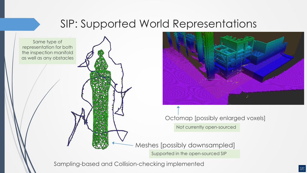
SIP: Supported World Representations
Meshes [possibly downsampled]
Octomap [possibly enlarged voxels]
Sampling-based and Collision-checking implemented
Not currently open-sourced
Supported in the open-sourced SIP
Same type of representation for both the inspection manifold as well as any obstacles
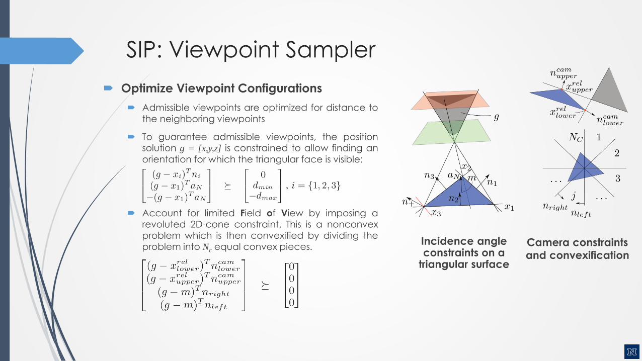
SIP: Viewpoint Sampler
Optimize Viewpoint Configurations
Admissible viewpoints are optimized for distance tothe neighboring viewpoints
To guarantee admissible viewpoints, the positionsolution g = [x,y,z] is constrained to allow finding an
orientation for which the triangular face is visible:
Account for limited Field of View by imposing arevoluted 2D-cone constraint. This is a nonconvexproblem which is then convexified by dividing theproblem into Nc equal convex pieces.
Incidence angle constraints on a
triangular surface
Camera constraints
and convexification
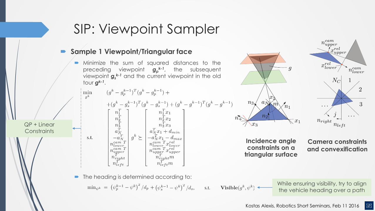
SIP: Viewpoint Sampler
Sample 1 Viewpoint/Triangular face
Minimize the sum of squared distances to the
preceding viewpoint gpk-1, the subsequent
viewpoint gsk-1 and the current viewpoint in the old
tour gk-1.
The heading is determined according to:
While ensuring visibility, try to align the vehicle heading over a path
Incidence angle constraints on a
triangular surface
Camera constraints
and convexification
QP + Linear Constraints
Kostas Alexis, Robotics Short Seminars, Feb 11 2016
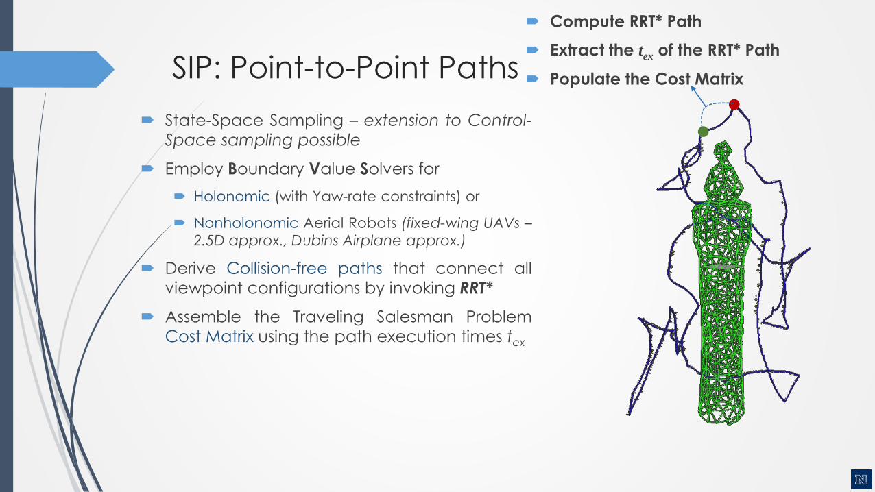
SIP: Point-to-Point Paths
State-Space Sampling – extension to Control-
Space sampling possible
Employ Boundary Value Solvers for
Holonomic (with Yaw-rate constraints) or
Nonholonomic Aerial Robots (fixed-wing UAVs –
2.5D approx., Dubins Airplane approx.)
Derive Collision-free paths that connect all
viewpoint configurations by invoking RRT*
Assemble the Traveling Salesman Problem
Cost Matrix using the path execution times tex
Compute RRT* Path
Extract the tex of the RRT* Path
Populate the Cost Matrix

SIP: TSP Solution
Solve the (possibly asymmetric) TSP problem
using the Lin-Kernighan-Helsgaun heuristic
Extract the Optimized Inspection Tour
O(N2.2) , N the number of viewpoints
Kostas Alexis, Robotics Short Seminars, Feb 11 2016

Autonomous Inspection
Kostas Alexis, Robotics Short Seminars, Feb 11 2016
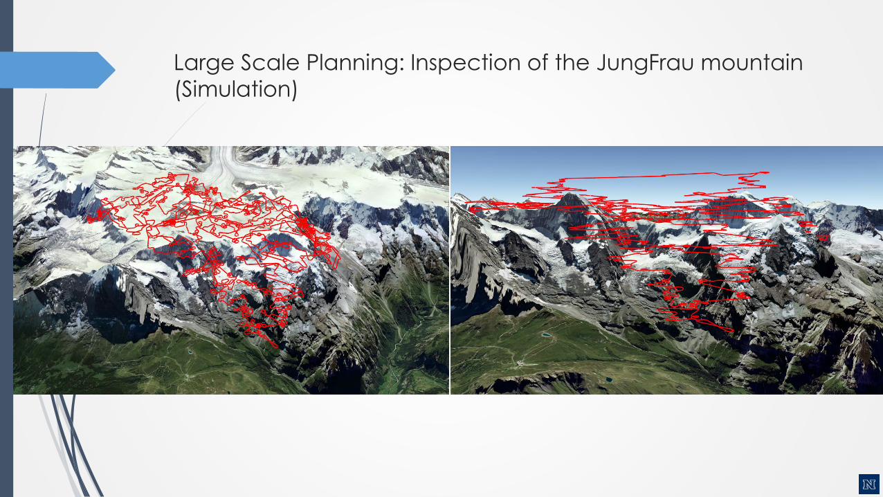
Large Scale Planning: Inspection of the JungFrau mountain
(Simulation)

Uniform Coverage Inspection Path-Planning (UC3D)
Problem: given a representation of
the structure, compute a full
coverage path that provides
uniform focus on the details.
Challenge: provide a good solution
at “anytime”.
Goal: an efficient “anytime”inspection path planning algorithm
with uniformity guarantees.
Key for the solution: Voronoi-based
remeshing techniques and a
combination of viewpoint
computation algorithms, collision-
free planners and efficient TSP
solvers.
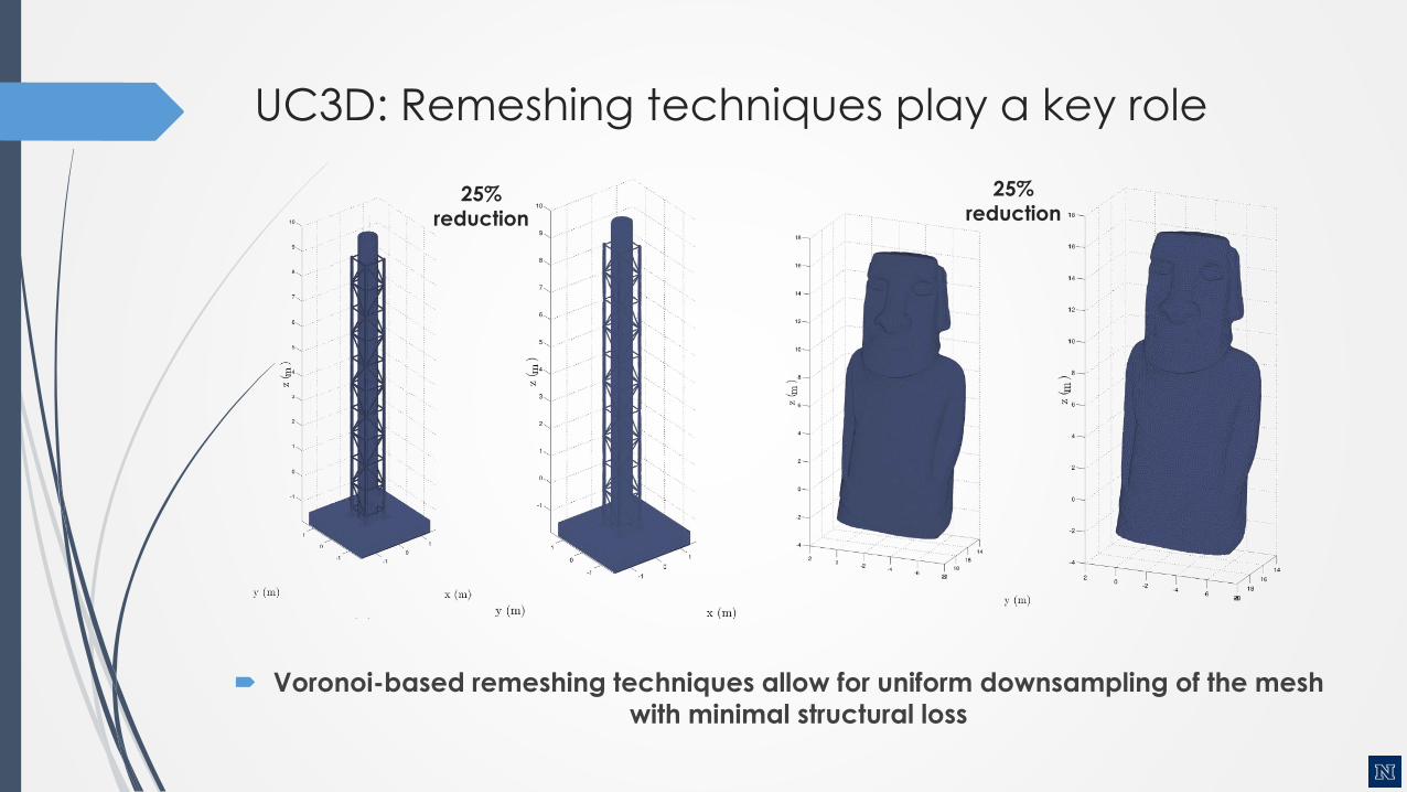
UC3D: Remeshing techniques play a key role
Voronoi-based remeshing techniques allow for uniform downsampling of the mesh
with minimal structural loss
25% reduction
25% reduction
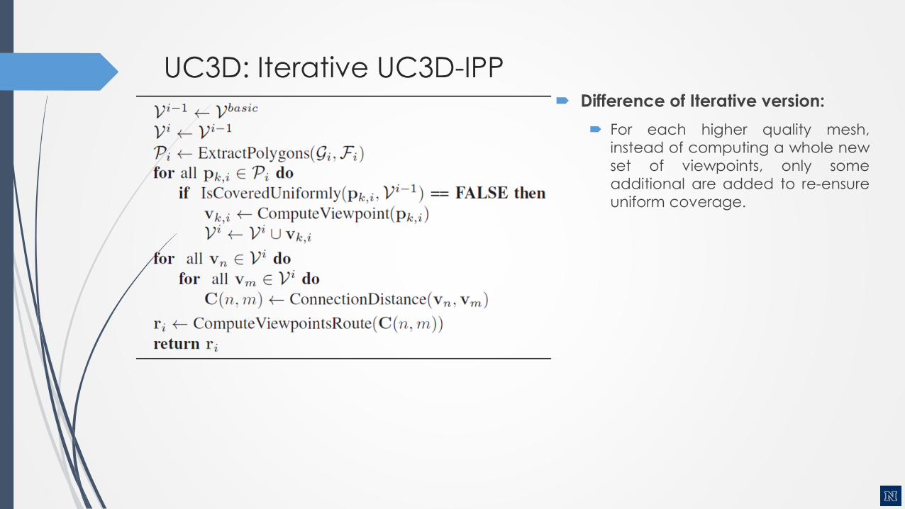
UC3D: Iterative UC3D-IPP Difference of Iterative version:
For each higher quality mesh,
instead of computing a whole new
set of viewpoints, only some
additional are added to re-ensure
uniform coverage.

UC3D: Basic UC3D-IPP Result
Sequential execution of the basic UC3D-IPP algorithm
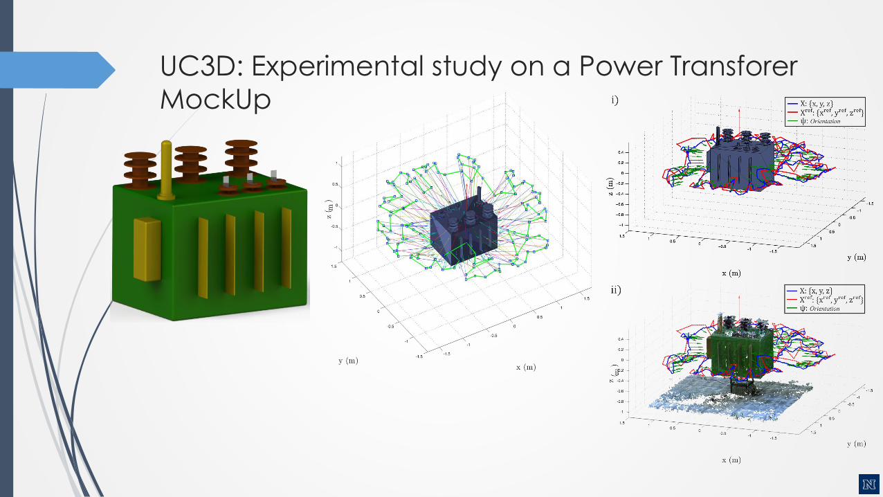
UC3D: Experimental study on a Power Transforer
MockUp

Uniform Coverage Inspection Path-Planning
Kostas Alexis, Robotics Short Seminars, Feb 11 2016

Real-life is 3D, Complex, Possibly unknown
Known Model to Compute Global Inspection Path
Unknown Model – execute Autonomous Exploration
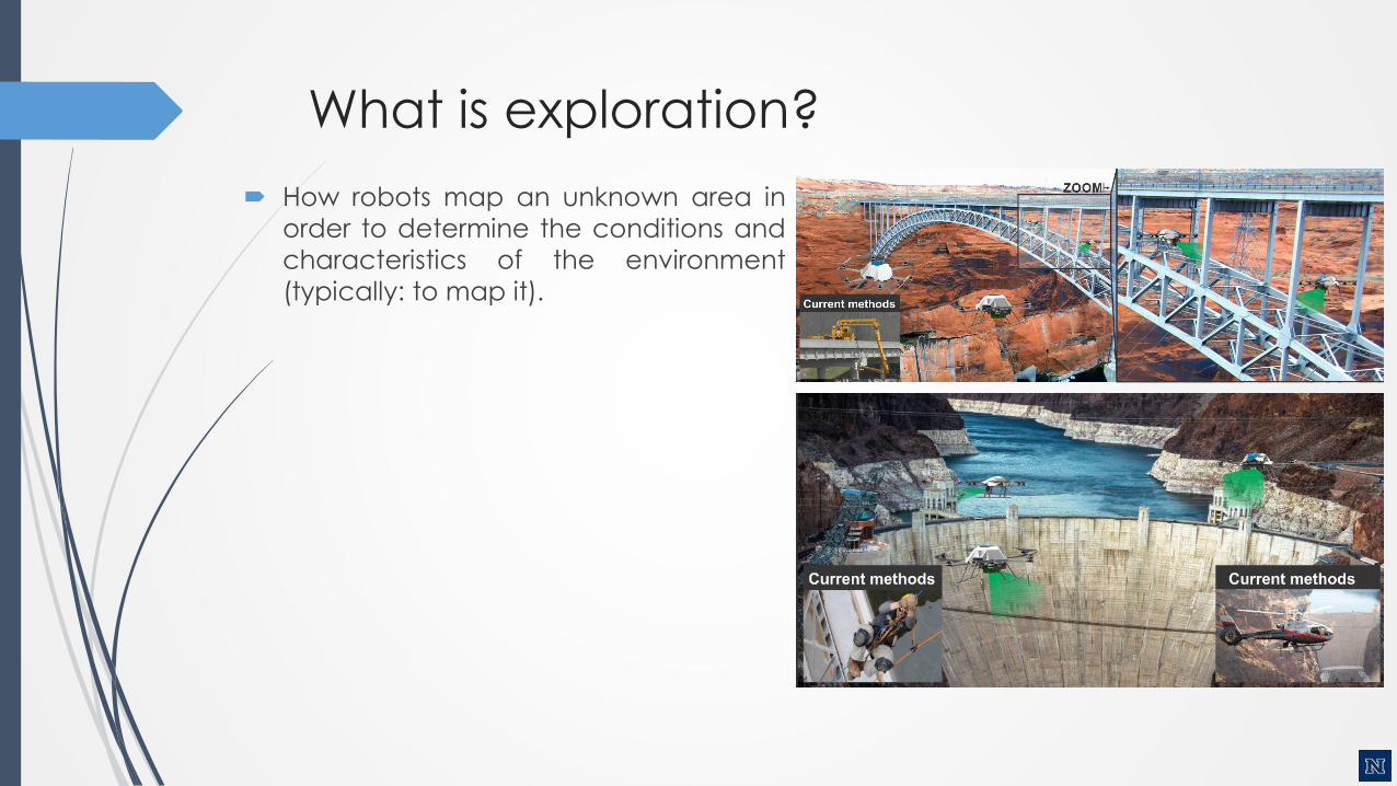
What is exploration?
How robots map an unknown area in
order to determine the conditions and
characteristics of the environment
(typically: to map it).
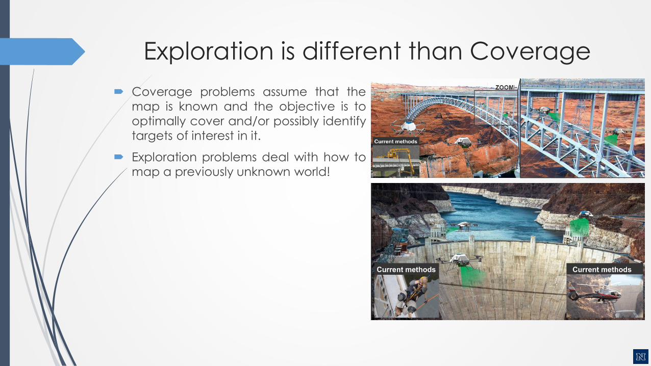
Exploration is different than Coverage
Coverage problems assume that the
map is known and the objective is to
optimally cover and/or possibly identify
targets of interest in it.
Exploration problems deal with how to
map a previously unknown world!

Applications of Autonomous Exploration
Infrastructure monitoring and
maintenance
Rapid support of search and rescue
operations
Surveillance and reconnaissance
Operation in any environment not
suitable for human operators
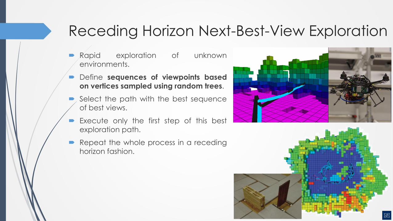
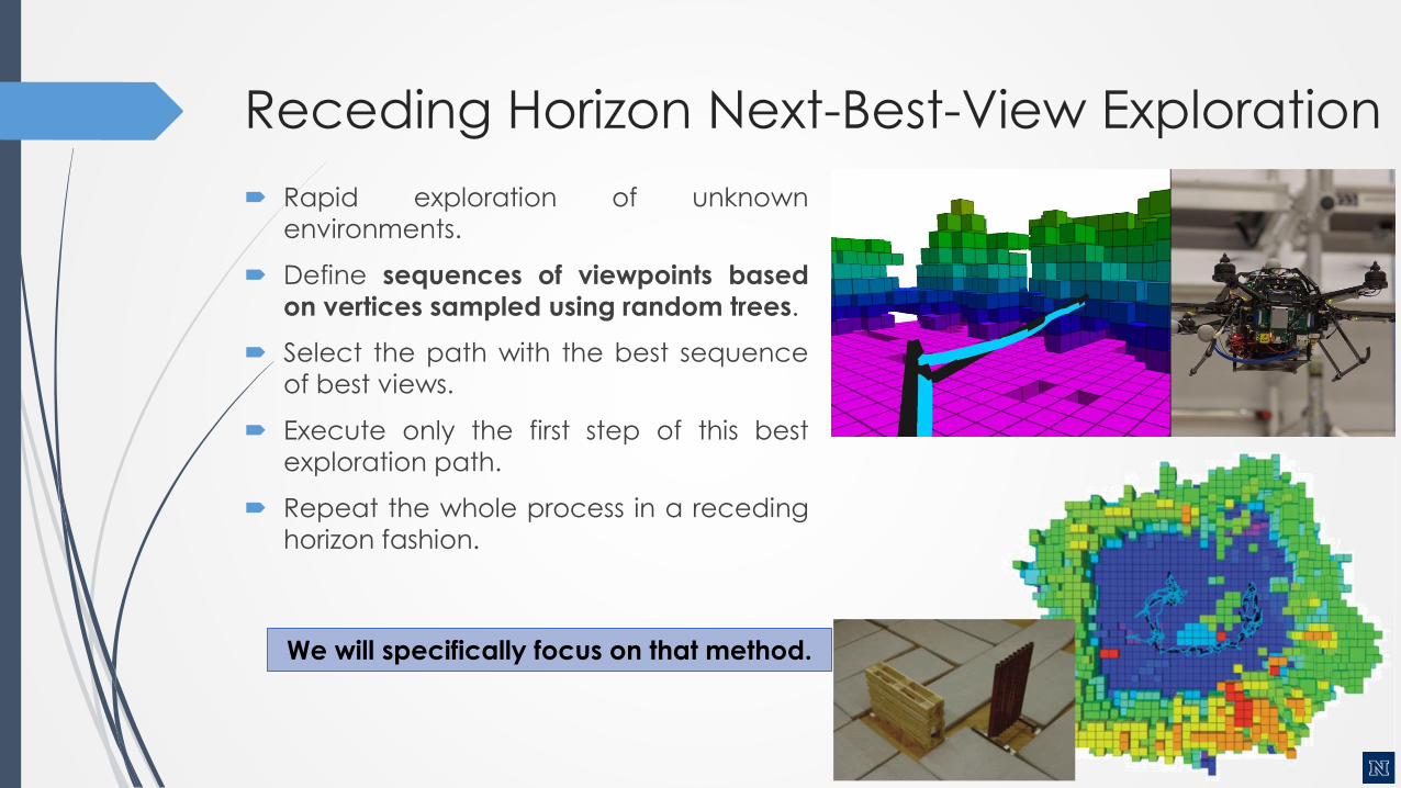
Receding Horizon Next-Best-View Exploration
Rapid exploration of unknown
environments.
Define sequences of viewpoints based
on vertices sampled using random trees.
Select the path with the best sequence
of best views.
Execute only the first step of this best
exploration path.
Repeat the whole process in a receding
horizon fashion.
We will specifically focus on that method.

The Exploration path planning problem
The exploration path planning problem consists in exploring a bounded 3Dspace 𝑉 ⊂ ℝ3. This is to determine which parts of the initially unmapped space𝑉𝑢𝑛𝑚 = 𝑉 are free 𝑉𝑓𝑟𝑒𝑒 ⊂ 𝑉 or occupied 𝑉𝑜𝑐𝑐 ⊂ 𝑉. The operation is subject tovehicle kinematic and dynamic constraints, localization uncertainty andlimitations of the employed sensor system with which the space is explored.
As for most sensors the perception stops at surfaces, hollow spaces or narrowpockets can sometimes not be explored with a given setup. This residualspace is denoted as 𝑉𝑟𝑒𝑠. The problem is considered to be fully solved when𝑉𝑓𝑟𝑒𝑒 ∪ 𝑉𝑜𝑐𝑐 = 𝑉\𝑉𝑟𝑒𝑠.
Due to the nature of the problem, a suitable path has to be computedonline and in real-time, as free space to navigate is not known prior to itsexploration.
Problem Definition

RH-NBVP Functional Principle
Kostas Alexis, Robotics Short Seminars, Feb 11 2016
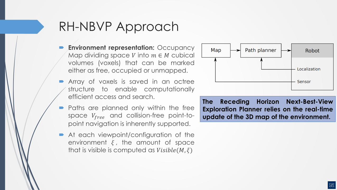
RH-NBVP Approach
Environment representation: Occupancy
Map dividing space 𝑉 into 𝑚 ∈ 𝑀 cubical
volumes (voxels) that can be marked
either as free, occupied or unmapped.
Array of voxels is saved in an octree
structure to enable computationally
efficient access and search.
Paths are planned only within the freespace 𝑉𝑓𝑟𝑒𝑒 and collision-free point-to-
point navigation is inherently supported.
At each viewpoint/configuration of the
environment 𝜉 , the amount of space
that is visible is computed as 𝑉𝑖𝑠𝑖𝑏𝑙𝑒(𝑀, 𝜉)
The Receding Horizon Next-Best-View
Exploration Planner relies on the real-time
update of the 3D map of the environment.
RH-NBVP Approach
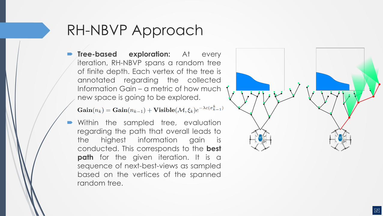
Tree-based exploration: At every
iteration, RH-NBVP spans a random tree
of finite depth. Each vertex of the tree is
annotated regarding the collected
Information Gain – a metric of how much
new space is going to be explored.
Within the sampled tree, evaluation
regarding the path that overall leads to
the highest information gain is
conducted. This corresponds to the best
path for the given iteration. It is asequence of next-best-views as sampled
based on the vertices of the spanned
random tree.
RH-NBVP Approach
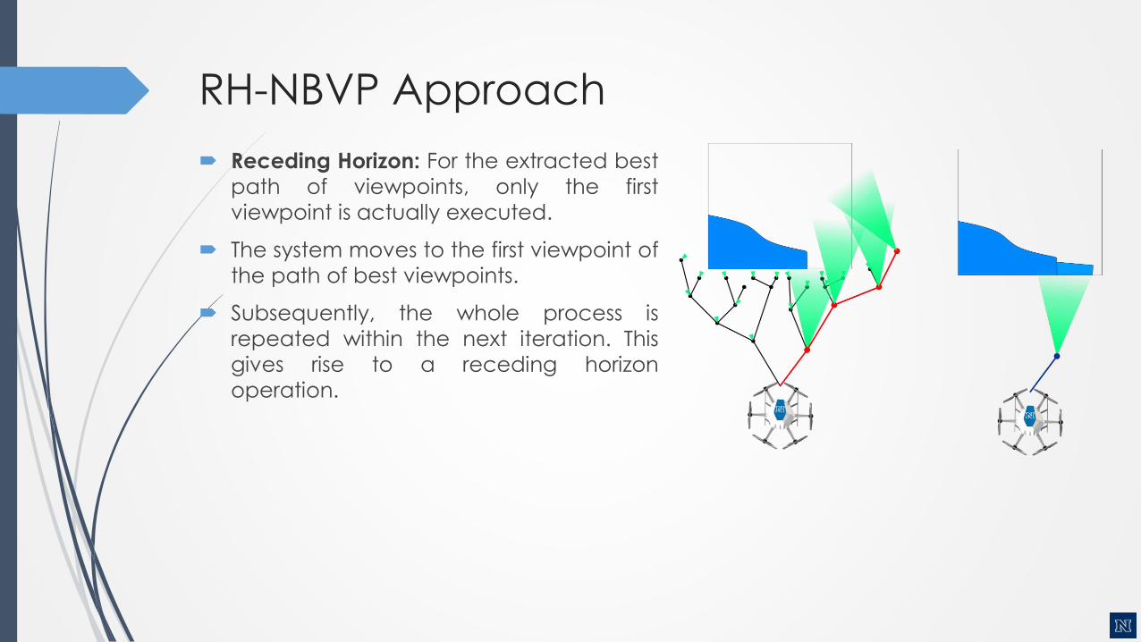
Receding Horizon: For the extracted best
path of viewpoints, only the first
viewpoint is actually executed.
The system moves to the first viewpoint of
the path of best viewpoints.
Subsequently, the whole process is
repeated within the next iteration. This
gives rise to a receding horizon
operation.

NBVP Iterative Step
RH-NBVP Algorithm
𝜉0 ←current vehicle configuration
Initialize 𝑻 with 𝜉0 and, unless first planner call, also previous best branch
𝑔𝑏𝑒𝑠𝑡 ← 0 // Set best gain to zero
𝑛𝑏𝑒𝑠𝑡 ← 𝑛0 𝜉0 // Set best node to root
𝑁𝑇 ←Number of nodes in 𝑻
while 𝑁𝑇 < 𝑁𝑚𝑎𝑥 or 𝑔𝑏𝑒𝑠𝑡 == 0 do
Incrementally build T by adding 𝑛𝑛𝑒𝑤 𝜉𝑛𝑒𝑤
𝑁𝑇 ← 𝑁𝑇 + 1
if 𝐺𝑎𝑖𝑛 𝑛𝑛𝑒𝑤 > 𝑔𝑏𝑒𝑠𝑡 then
𝑛𝑏𝑒𝑠𝑡 ← 𝑛𝑛𝑒𝑤
𝑔𝑏𝑒𝑠𝑡 ← 𝐺𝑎𝑖𝑛 𝑛𝑛𝑒𝑤
if 𝑁𝑇 > 𝑁𝑇𝑂𝑇 then
Terminate exploration
σ ← 𝑬𝒙𝒕𝒓𝒂𝒄𝒕𝑩𝒆𝒔𝒕𝑷𝒂𝒕𝒉𝑺𝒆𝒈𝒎𝒆𝒏𝒕 𝑛𝑏𝑒𝑠𝑡
Delete 𝑻
return σ

RH-NBVP in Action
RH-NBVP Remarks
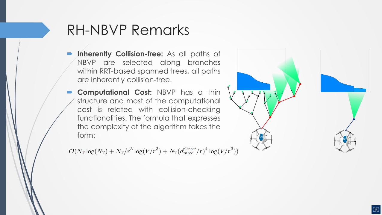
Inherently Collision-free: As all paths of
NBVP are selected along branches
within RRT-based spanned trees, all paths
are inherently collision-free.
Computational Cost: NBVP has a thin
structure and most of the computational
cost is related with collision-checking
functionalities. The formula that expresses
the complexity of the algorithm takes the
form:

RH-NBVP Evaluation (Simulation)
Kostas Alexis, Robotics Short Seminars, Feb 11 2016

Multi-Agent RH-NBVP Simulation
Kostas Alexis, Robotics Short Seminars, Feb 11 2016
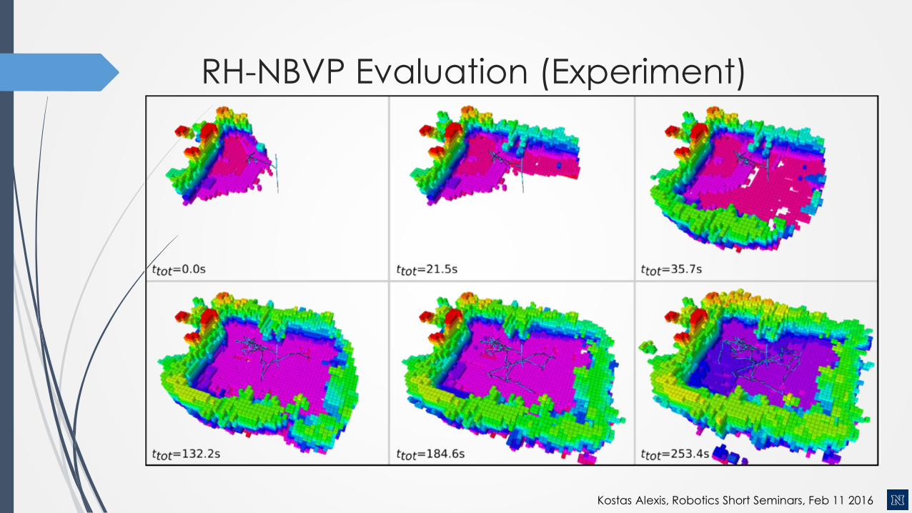
RH-NBVP Evaluation (Experiment)
Kostas Alexis, Robotics Short Seminars, Feb 11 2016
NBVP Evaluation (Experiment)
Kostas Alexis, Robotics Short Seminars, Feb 11 2016
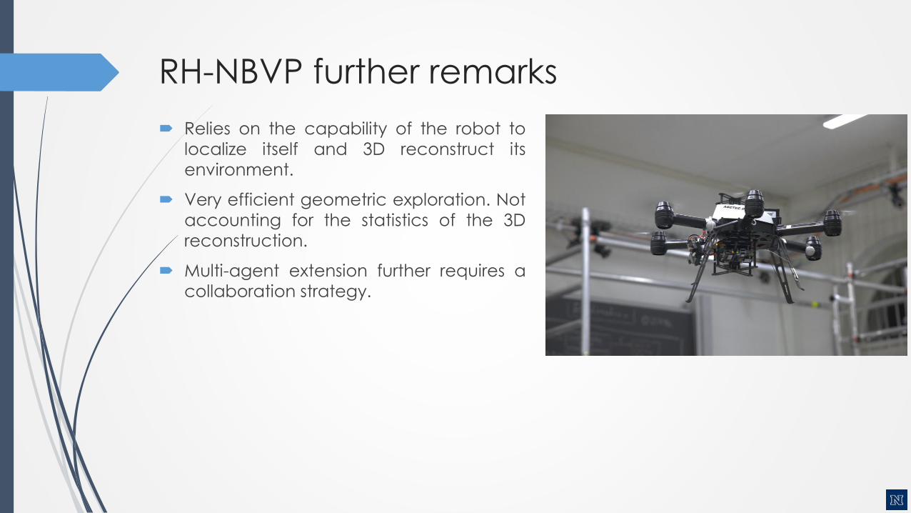
RH-NBVP further remarks
Relies on the capability of the robot to
localize itself and 3D reconstruct its
environment.
Very efficient geometric exploration. Not
accounting for the statistics of the 3D
reconstruction.
Multi-agent extension further requires a
collaboration strategy.
Be a developer
Open Source Code:
Structural Inspection Planner:
https://github.com/ethz-asl/StructuralInspectionPlanner
Next-Best-View Planner:
https://github.com/ethz-asl/nbvplanner
Associated Datasets:
Structural Inspection Planner:
https://github.com/ethz-asl/StructuralInspectionPlanner/wiki/Example-Results
Next-Best-View Planner:
https://github.com/ethz-asl/nbvplanner/wiki/Example-Results
Solar-powered UAV Sensing & Mapping:
http://projects.asl.ethz.ch/datasets/doku.php?id=fsr2015
Kostas Alexis, Robotics Short Seminars, Feb 11 2016
References
A. Bircher, K. Alexis, M. Burri, P. Oettershagen, S. Omari, T. Mantel, R. Siegwart, "StructuralInspection Path Planning via Iterative Viewpoint Resampling with Application to Aerial Robotics",IEEE International Conference on Robotics & Automation, May 26-30, 2015 (ICRA 2015), Seattle,Washington, USA
Kostas Alexis, Christos Papachristos, Roland Siegwart, Anthony Tzes, "Uniform Coverage StructuralInspection Path-Planning for Micro Aerial Vehicles", Multiconference on Systems and Control(MSC), 2015, Novotel Sydney Manly Pacific, Sydney Australia. 21-23 September, 2015
K. Alexis, G. Darivianakis, M. Burri, and R. Siegwart, "Aerial robotic contact-based inspection:planning and control", Autonomous Robots, Springer US, DOI: 10.1007/s10514-015-9485-5, ISSN:0929-5593, http://dx.doi.org/10.1007/s10514-015-9485-5
A. Bircher, K. Alexis, U. Schwesinger, S. Omari, M. Burri and R. Siegwart "An Incremental Sampling–based approach to Inspection Planning: the Rapidly–exploring Random Tree Of Trees", acceptedat the Robotica Journal (awaiting publication)
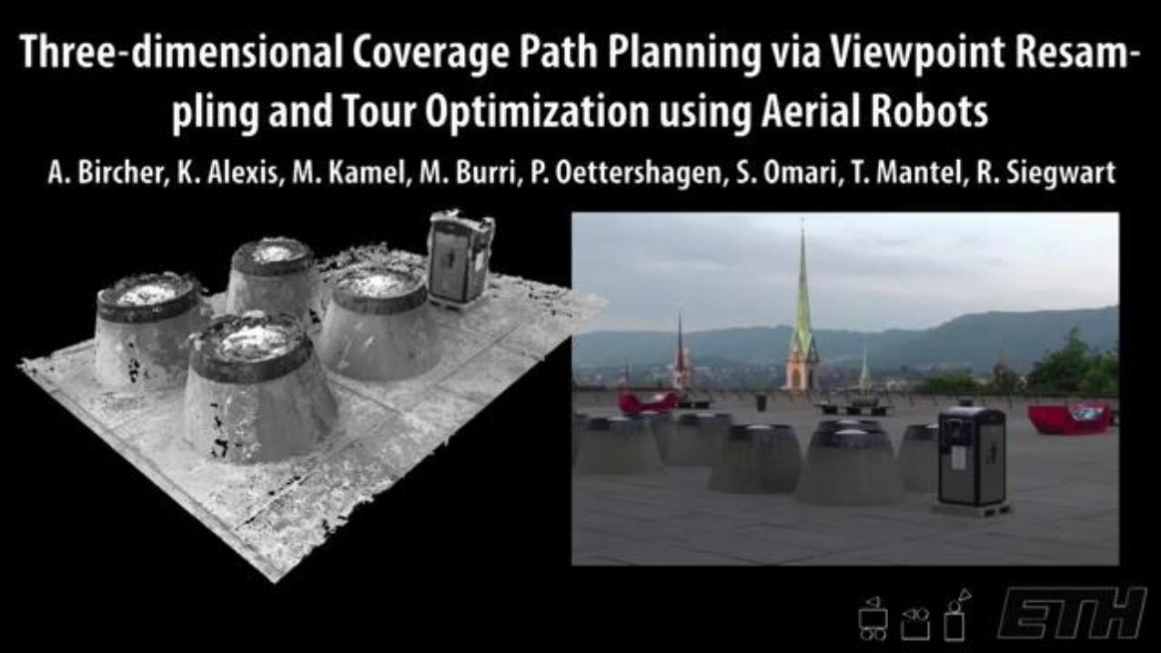
A. Bircher, M. Kamel, K. Alexis, M. Burri, P. Oettershagen, S. Omari, T. Mantel, R. Siegwart, "Three-dimensional Coverage Path Planning via Viewpoint Resampling and Tour Optimization for AerialRobots", Autonomous Robots, Springer US, DOI: 10.1007/s10514-015-9517-1, ISSN: 1573-7527
A. Bircher, M. Kamel, K. Alexis, H. Oleynikova, R. Siegwart, "Receding Horizon "Next-Best-View"Planner for 3D Exploration", IEEE International Conference on Robotics and Automation 2016(ICRA 2016), Stockholm, Sweden (Accepted - to be presented)

Thank you! Please ask your question!


![[ , ] Autonomous Human Robot Interactive Skills](https://img.pdfslide.us/doc/110x75/577cc35f1a28aba71195d883/-autonomous-human-robot-interactive-skills.jpg)