Embed Size (px)
Citation preview
This article appeared in a journal published by Elsevier. The attachedcopy is furnished to the author for internal non-commercial researchand education use, including for instruction at the authors institution
and sharing with colleagues.
Other uses, including reproduction and distribution, or selling orlicensing copies, or posting to personal, institutional or third party
websites are prohibited.
In most cases authors are permitted to post their version of thearticle (e.g. in Word or Tex form) to their personal website orinstitutional repository. Authors requiring further information
regarding Elsevier’s archiving and manuscript policies areencouraged to visit:
http://www.elsevier.com/copyright
Author's personal copy
Magnetic properties of sediments from major rivers, aeolian dust, loess soiland desert in China
Chao Li a, Shouye Yang a,⇑, Weiguo Zhang b
a State Key Laboratory of Marine Geology, Tongji University, Shanghai 200092, PR Chinab State Key Laboratory of Estuarine and Coastal Research, East China Normal University, Shanghai 200062, PR China
a r t i c l e i n f o
Article history:Received 17 June 2011Received in revised form 1 October 2011Accepted 21 October 2011Available online 25 November 2011
Keywords:Magnetic propertyRiver sedimentLoess–paleosolDesertDustChina
a b s t r a c t
The continent of China delivers huge terrigenous sediments to the East Asian marginal seas and north-west Pacific Ocean by riverine and aeolian inputs, which exerts a great impact on marine sedimentation,primary productivity and biogeochemical cycle. In this study, magnetic properties of the sediments fromthe Changjiang and Huanghe river systems were investigated, in order to provide potential provenancetracers. Besides, the top soil from the Loess Plateau, Taklimakan desert sand and dust storm particleswere comparatively studied to reveal the controls of magnetic properties in various depositional environ-ments.
The Changjiang sediment is characterized by the highest concentration of magnetic minerals and thelargest variations for most magnetic parameters, while the Huanghe sediment has much lower contentof magnetic minerals. The loess soil sediment yields the highest frequency-dependent susceptibilityvfd%, while the aeolian dust has similar magnetic susceptibility but higher saturation isothermal remnantmagnetization and lower anhysteretic remnant magnetization vARM. The desert sand has the lowest val-ues of all magnetic parameters, indicating the lowest ferrimagnetic mineral concentration with coarsergrain size. The magnetic properties of the Changjiang sediments are primarily determined by the diver-sity of lithology in its large drainage basin, while the sediment grain size basically accounts for the var-iation of magnetic parameters in the Huanghe sediment. The gradual increase of vfd% towards the lowerreaches suggests it may potentially indicate grain size fractionation in the catchments. Although somemagnetic parameters can apparently discriminate the origins of fluvial and aeolian sediments, reliablemagnetic proxy for distinguishing sediment origins in marine environment can only be established ifhydrodynamic differentiation and post-depositional diagenetic alteration of magnetic minerals are fullyunderstood.
� 2011 Elsevier Ltd. All rights reserved.
1. Introduction
The land–ocean interactions and relating earth surface pro-cesses are being conceived worldwide. Owing to the unique topog-raphy and monsoon climate, the East Asian continent delivers ahuge amount of terrigenous material primarily through riverineand aeolian transport to the East Asian marginal seas and north-west Pacific Ocean, which exerts a great impact on marine sedi-mentation, primary productivity and biogeochemical cycle(Milliman and Meade, 1983; Duce et al., 1980; Jickells et al.,2005; Maher et al., 2010). The Changjiang (Yangtze River) andthe Huanghe (Yellow River) are the two largest rivers in China(Fig. 1), transporting about 1.5 � 109 tons of sediment in totalannually to the estuarine and shelf areas, which accounts for about
10% of the global sediment discharge (Milliman and Meade, 1983).Nevertheless, the sediment loads of the Changjiang and Huanghedecrease significantly over the last two decades primarily due tothe constructions of numerous reservoirs in both drainage basinssuch as the world’s largest dam, the Three Gorges Dam (Yanget al., 2006, 2007). The tremendous material from the Changjiangand Huanghe dominates the sedimentation in the East Asian mar-ginal seas such as the Bohai, Yellow Sea and East China Sea. How-ever, major part of the fluvial sediments is trapped in the deltaic,coastal and continental shelf due to the mild gradient, estuarineprocess and littoral currents (Chen et al., 1985), and thereby thefine-grained terrigenous material to the open ocean is mostlydelivered by atmospheric dust (Duce et al., 1980; Jickells et al.,2005; Maher et al., 2010).
The global dust flux is estimated to range from 1000 to 2150 Tg/yr (Andreae and Rosenfeld, 2008), of which 8% is from centralChina (Tanaka and Chiba, 2006). Compared to the river input,nutrients and trace elements transported by aeolian dust are moresignificant in the open ocean (Jickells et al., 2005). Dust acts as one
1367-9120/$ - see front matter � 2011 Elsevier Ltd. All rights reserved.doi:10.1016/j.jseaes.2011.10.010
⇑ Corresponding author. Address: State Key Laboratory of Marine Geology, TongjiUniversity, 1239 Siping Road, Shanghai 200092, PR China. Tel.: +86 21 6598 9130;fax: +86 21 6598 6278.
E-mail address: [email protected] (S. Yang).
Journal of Asian Earth Sciences 45 (2012) 190–200
Contents lists available at SciVerse ScienceDirect
Journal of Asian Earth Sciences
journal homepage: www.elsevier .com/locate / jseaes
Author's personal copy
main source of iron to the open ocean where the availability of ironmay limit primary productivity (Martin, 1990; Jickells et al., 2005).Bory et al. (2003) found that the dust from both the Mongolianand Taklimakan deserts could be recognized in ice cores fromGreenland, and more recent study suggests that the finest particlesfrom Taklimakan dust even had circled the globe more than once(Uno et al., 2009). Overall, Sandy desert, Gobi desert, Loess Plateauand the mixed barren soil in Northern China and Mongolia, are themain sources of Asian dust (Duce et al., 1980; Jickells et al., 2005;Engelbrecht and Derbyshire, 2010; Maher et al., 2010).
Although the Changjiang, Huanghe and aeolian dust are consid-ered to be the main sources of terrigenous input to the west Pacificmarginal seas, the discrimination method of these different sedi-ment sources are still not well established (Yang et al., 2003). Tra-ditional studies on provenance discrimination of the Changjiangand Huanghe sediments were primarily based on geochemicaland mineralogical methods, while magnetic properties of thesetwo river sediments have only been investigated until recent years(Niu et al., 2008; Zhang et al., 2008; Wang et al., 2009; Liu et al.,2010b), with a main aim to identify the sediment origins in marineenvironments. As a fast, low-cost and sensitive analysis of sedi-ment character, environmental magnetism has been developedabout 30 years ago (Thompson and Oldfield, 1986), and widely ap-plied in paleoenvironmental study (Heller and Liu, 1986; Kukla andAn, 1989; Zheng et al., 1991; Maher and Thompson, 1991; Verosuband Roberts, 1995; Kissel et al., 2003; Liu et al., 2007a; Roberts,2007), agrology (Thompson and Oldfield, 1986; Taylor et al.,1987), and heavy metal contamination indication (Scoullos et al.,1979; Hunt et al., 1984; Zhang et al., 2001; Li et al., 2011). Previousstudies on magnetic property of the Changjiang and Huanghe sed-iments primarily gave emphasis to the estuarine and inner shelfareas (Liu et al., 2003, 2010b; Zhang and Yu, 2003; Zhang et al.,2008; Wang et al., 2004, 2009, 2010; Niu et al., 2008; Zhenget al., 2010; Horng and Huh, 2011), while the whole drainage ba-sins, especially the upper and middle reaches, and the major trib-utaries have rarely been investigated. Compared to the fluvialsediments, environmental magnetism of the loess–paleosol profileand aeolian dust has been more widely applied to decipher theQuaternary paleoenvironmental changes (Liu, 1985; Heller and
Liu, 1986; Kukla and An, 1989; Maher and Thompson, 1991; Zhenget al., 1991; Liu et al., 2007a; Sun et al., 2010; Zhao and Roberts,2010). But detailed comparative study on environmental magne-tism of the sediments from river, loess–paleosol and aeolian dust,however, has seldom been carried out yet. Furthermore, whethermagnetic proxy can be established to identify the sediment originsin marine environments remain enigmatic (Liu et al., 2010a; Wanget al., 2010; Zheng et al., 2010; Horng and Huh, 2011).
The present study attempts to compare magnetic properties ofthe river sediment, aeolian dust, loess–paleosol, and desert sand.Meantime, systematic sediment samples taken from the majortributaries and mainstream of the Changjiang and Huanghe werealso investigated, aiming to provide a better understanding of mag-netic properties in the large rivers. Furthermore, this paperdiscusses the possibility of using magnetic properties to discrimi-nate the sediment origins of East China marginal seas.
2. Geological settings
The Changjiang is the longest river in Asia, which flows about6300 km from the glaciers on the Tibetan Plateau, with elevationabove 4000 m and finally empties into the East China Sea. The rivercourse of the Changjiang is traditionally divided into three sec-tions. The mountainous upper reaches ranges from the headwaterin western Tibetan Plateau to the city of Yichang. Particularly, thesection from confluence with the Batang River, near Yushu, to Yibinis named Jinshajiang River. The middle reaches flows through a flatplain from Yichang to Hukou, and the lower reaches stretches fromHukou to the estuary in Shanghai before finally entering the EastChina Sea. The Changjiang drains one-fifth of China’s land areaand its watershed feeds one-third of China’s population. The waterdischarge and sediment load of the Changjiang are about 900 km3/yr and 4.78 � 108 t/yr, respectively, based on the long term hydro-logical observation (Milliman and Meade, 1983; Yang et al., 2004).The Changjiang catchment is primarily located in the temperateclimate zone, with an annual precipitation of 1100 mm. Framedby the Mesozoic Yenshanian orogenic belt and mostly situated inthe Yangtze Craton, the Changjiang river basin is characterizedby complex geological settings. The upper basin comprises widely
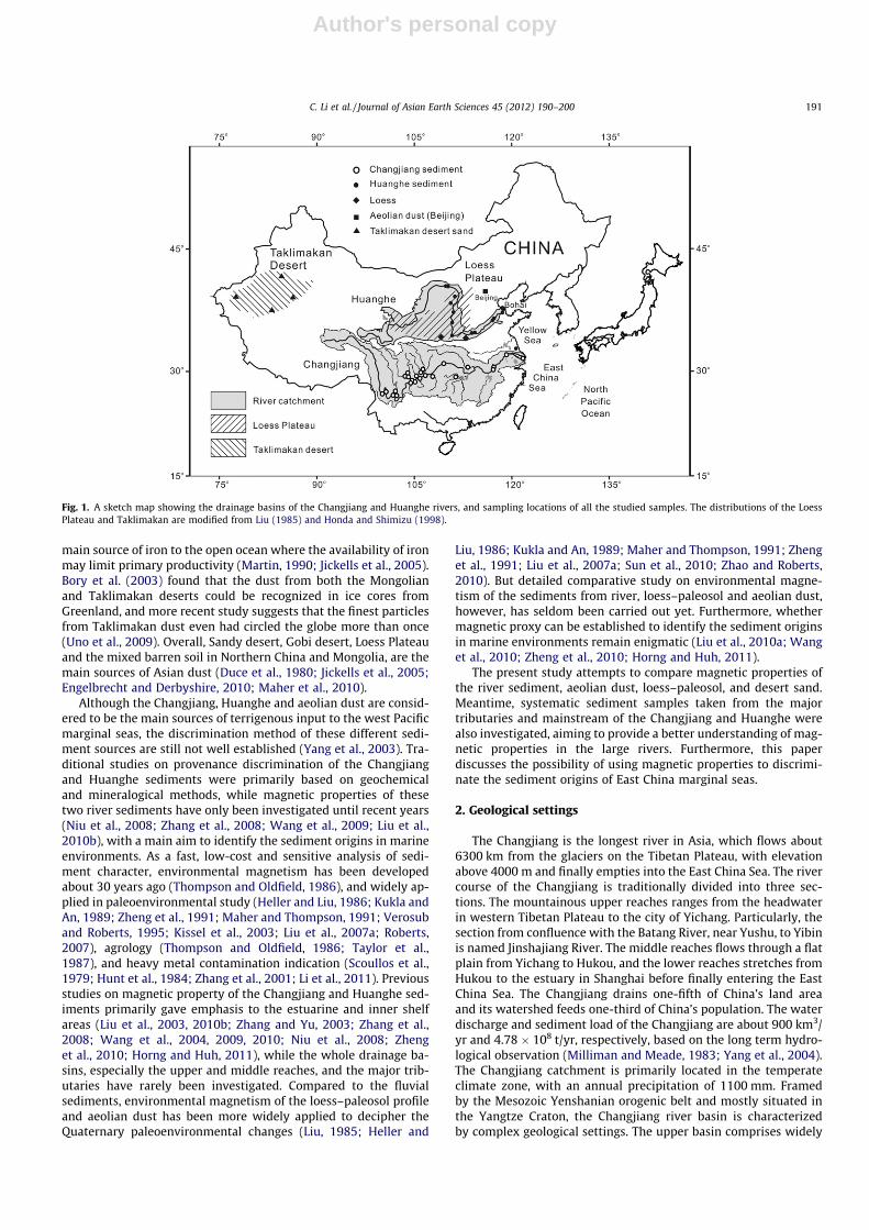
Fig. 1. A sketch map showing the drainage basins of the Changjiang and Huanghe rivers, and sampling locations of all the studied samples. The distributions of the LoessPlateau and Taklimakan are modified from Liu (1985) and Honda and Shimizu (1998).
C. Li et al. / Journal of Asian Earth Sciences 45 (2012) 190–200 191
Author's personal copy
distributed Paleozoic carbonate rock, Jurassic red sandstone andMesozoic igneous rocks, while the middle–lower valley mostlyconsists of Paleozoic and Quaternary sedimentary rocks, togetherwith intermediate to felsic igneous rocks (China Geological Survey,2004; Yang et al., 2004).
The Huanghe is the second largest river in China, with thedrainage basin of 0.77 � 106 km2. The vigorous upper reaches ofthe Huanghe starts from the headwater to Hekouzhen in InnerMongolia. The middle reaches ends at Taohuayu in Zhengzhou City,and the lower reaches ranges from Taohuayu to the delta on theBohai Sea. Though both sourced from the Tibetan Plateau, theHuanghe has significantly different geographic, hydrological andgeological characteristics from the Changjiang. The Huanghe is fea-tured by its low water discharge but tremendous amount of sus-pended sediment, about 1.08 � 109 t/yr, after it drains the LoessPlateau (Milliman and Meade, 1983; Ren and Shi, 1986). Althougha large proportion of its upper basin is covered by Cenozoic evap-orite, the loess terrain in the middle reaches (nearly 40% of thewhole drainage area) contributes about 90% of suspended load tothe Huanghe (Ren and Shi, 1986).
The Loess Plateau in north central China is now recognized asone of the best terrestrial archives for reconstructing Quaternarypaleoenvironmental changes in East Asia. It covers much of themiddle part of the Huanghe catchment, with an average elevationabout 1200 m and an area of about 4.4 � 105 km2 (Liu, 1985). TheLoess Plateau comprises a thick succession of loess with interstrat-ified paleosols predominantly formed 2.5 Myr ago (Liu, 1985;Heller and Liu, 1986), and is highly subject to erosion because ofsparse vegetation, heavy precipitation in summer, and extensivegullying.
In addition, silty samples from the Taklimakan Desert are alsostudied in this paper in order to make a detailed comparison withthose fluvial sediments and loess–paleosol samples. The Taklima-kan Desert in the Tarim Basin of Central Asia with an area of3.37 � 105 km2, is the world’s 17th largest desert and the secondlargest shifting sand desert (Zhu et al., 1980). It is bounded bythe Kunlun Mountains to the south, and the Pamir and Tian ShanMountains to the west and north respectively.
3. Materials and methods
3.1. Sample sources
A total of 48 samples were collected from diverse environmentsincluding river, loess, desert and aeolian dust. For those river sed-iments, 24 floodplain and suspended sediments were collectedfrom the mainstream and major tributaries of the Changjiang inApril, 2003 and August, 2004. The floodplain sediments of eachabout 500 g were taken using a pre-cleaned spoon from the sub-surface at 5 cm depth of the floodplains, and the sampling loca-tions covered the whole river system from the upper Jinshajiangdownstream to the river mouth (Yang et al., 2009; Fig. 1; Table 1).The suspended particulate matter (SPM) was filtered in situ by0.45 lm pre-cleaned membrane filter. A total of ten SPM samplesin April, 2009 and five floodplain sediments were taken from theHuanghe mainstream and tributaries in September, 2009. For com-parison, two top soil samples were taken from the loess–paleosolprofiles in Mangshan and Xi’an respectively. Mangshan is locatednear the most southeastern margin of the Loess Plateau. It is sepa-rated by the Huanghe and represents the transition from aeolianloess landforms in the northwest to fluvial terrains in the east(Jiang et al., 2007). Cutting through this Mangshan plateau, theHuanghe drains the North China Plain with a mild gradient beforefinally entering into the Bohai Sea. Another soil sample was takenfrom a loess–paleosol profile near Xi’an City, which is locatedabout 350 km west of the Mangshan site. In addition, four desert
samples were collected from the Taklimakan Desert, and three dustsamples from a dust storm happened in Beijing on April 17–18,2006 (Zheng and Zhang, 2008). All of these sampling locationsare shown in Fig. 1 and Table 1.
3.2. Measurement of magnetic properties
Major magnetic parameters used in environmental magnetismstudy include specific magnetic susceptibility (v), AnhystereticRemnant Magnetization (ARM), and Saturation Isothermal Rema-nent Magnetization (SIRM). Low (0.47 kHz) and high (4.7 kHz)
Table 1Sediment sample inventory from the Changjiang and Huanghe rivers, loess, aeoliandust and Taklimakan desert.
Samples Characters Locations Coordinates
Changjiang SPMCJ-SPM-1 SPM Jinshajiang 26�5302500N, 99�5704600ECJ-SPM-2 SPM Jinshajiang 26�3602100N, 101�4800100ECJ-SPM-3 SPM Daduhe 29�3301100N, 103�4505400ECJ-SPM-4 SPM Mainstream 28�4600700N, 104�3704500ECJ-SPM-5 SPM Mainstream 28�5400700N, 105�2605800ECJ-SPM-6 SPM Mainstream 29�3305200N, 106�3500800ECJ-SPM-7 SPM Mainstream 30�4804400N, 108�2300100ECJ-SPM-8 SPM Hanjiang 30�2204700N, 113�2604800ECJ-SPM-9 SPM Mainstream 30�4601200N, 117�3802200ECJ-SPM-10 SPM Mainstream 31�5702300N, 120�5104000E
Changjiang floodplain sedimentsCJ-FP-1 Floodplain Mainstream 26�4704400N, 100�2504400ECJ-FP-2 Floodplain Yalongjiang 26�3702900N, 101�4803800ECJ-FP-3 Floodplain Mainstream 26�3602100N, 101�4800300ECJ-FP-4 Floodplain Mainstream 29�3301300N, 103�4503600ECJ-FP-5 Floodplain Mainstream 28�4601900N, 104�3800400ECJ-FP-6 Floodplain Minjiang 28�4604000N, 104�3702300ECJ-FP-7 Floodplain Mainstream 28�5401100N, 105�2605800ECJ-FP-8 Floodplain Tuojiang 28�5401200N, 105�2605600ECJ-FP-9 Floodplain Fujiang 29�5905200N, 106�1303700ECJ-FP-10 Floodplain Jialingjiang 30�0003700N, 106�1603700ECJ-FP-11 Floodplain Wujiang 29�4105800N, 107�2402800ECJ-FP-13 Floodplain Yuanjiang 29�0102600N, 111�4101600ECJ-FP-12 Floodplain Mainstream 30�4601200N, 117�3802200ECJ-FP-14 Floodplain Mainstream 31�4704900N, 121�2505200E
Huanghe SPMHH-SPM-1 SPM Mainstream 40�3105700N, 109�5502800EHH-SPM-2 SPM Kuyehe 38�2300200N, 110�4404700EHH-SPM-3 SPM Tuweihe 38�3001500N, 110�2003100EHH-SPM-4 SPM Mainstream 37�0204000N, 110�2602500EHH-SPM-5 SPM Mainstream 35�3503800N, 110�3700000EHH-SPM-6 SPM Mainstream 34�3603600N, 110�1701700EHH-SPM-7 SPM Mainstream 34�5403000N, 113�4103700EHH-SPM-8 SPM Mainstream 36�4404300N, 116�5301600EHH-SPM-9 SPM Mainstream 37�3602000N, 118�3201000EHH-SPM-10 SPM Mainstream 37�4504400N, 119�0904100E
Huanghe floodplain sedimentsHH-FP-1 Floodplain Mainstream 40�3002500N, 109�4604500EHH-FP-2 Floodplain Mainstream 34�5704200N, 113�3004900EHH-FP-3 Floodplain Mainstream 37�4202800N, 118�3905200EHH-FP-4 Floodplain Mainstream 37�4603300N, 119�1504800EHH-FP-5 Floodplain Mainstream 34�2201200N, 120�0502000E
Loess–paleosolTop soil-1 Soil Xi’an 34�1705400N, 109�0402400ETop soil-2 Soil Mangshan 34�5603300N, 113�3100100E
Aeolian dustDust-1 Dust Beijing 39�5902200N, 116�2003600EDust-2 Dust Beijing 39�5902300N, 116�2001900EDust-3 Dust Beijing 39�5902300N, 116�2002100E
Taklimakan desert sandDesert-1 Sand Taklimakan 41�0404300N, 83�2900200EDesert-2 Sand Taklimakan 39�4104300N, 76�0603300EDesert-3 Sand Taklimakan 37�0801300N, 79�3104000EDesert-4 Sand Taklimakan 38�2803500N, 85�4505300E
Note: SPM denotes suspended particulate matter.
192 C. Li et al. / Journal of Asian Earth Sciences 45 (2012) 190–200
Author's personal copy
frequency susceptibilities (vlf and vhf, respectively) were measuredwith a Bartington MS2B meter. Frequency-dependent susceptibil-ity was termed in percentage form vfd% = (vlf � vhf)/vlf � 100%.Hard IRM (HIRM) was calculated as HIRM = 0.5 � (SIRM +IRM�300mT), where IRM�300mT, i.e. remnant magnetization, was ob-tained by first saturating the sample in 1 T field, and then applyinga back-field of �300 mT to reverse the SIRM contributed bymagnetite or maghemite (Liu et al., 2007b). S�100 and S�300 weredefined as 0.5 � (SIRM � IRM�100mT)/SIRM � 100 and 0.5 � (SIRM� IRM�300mT)/SIRM � 100, respectively (Bloemendal et al., 1992).Susceptibility of ARM (vARM) was obtained in a 0.04 mT DC fieldsuperimposed on a peak AF demagnetization field of 100 mT. TheL-ratio was proposed by Liu et al. (2007b) and calculated asHIRM/(0.5 � (SIRM + IRM�100mT)) (Zhang et al., 2008). All the mag-netic measurements were carried out in the State Key Laboratoryof Estuarine and Coastal Research at East China Normal University.Details of the magnetic measurement were given in Zhang et al.(2008).
In general, v and SIRM primarily reflect the concentration ofmagnetic grains in sediments, but SIRM is irrelevant to the diamag-netic, paramagnetic super-paramagnetic domain (SP). The suscep-tibility of ARM (vARM) is roughly proportional to ferrimagneticgrains in the fine-grained stable single domain (SSD) (Maher,1988), and HIRM varies with concentration of high coercivity min-erals. Frequency-dependent susceptibility (vfd, in %) indicates con-tribution of fine viscous grains at the SSD/SP border to the totalferromagnetic assemblage (Thompson and Oldfield, 1986; Maherand Taylor, 1988; Evans and Heller, 2003). S-ratio is indicative ofrelative contribution of low coercivity minerals (e.g. magnetiteand maghemite) versus high coercivity magnetic minerals (e.g.hematite and goethite), and S-ratio = 1 generally suggests low-coercivity ferrimagnetic mineral (Evans and Heller, 2003).However, the indication of some magnetic parameters is stillcontroversial, e.g., HIRM can reflect concentration of hematiteand/or goethite only when the L-ratio is relatively constant (Liuet al., 2007b). More detailed interpretations of these magnetic
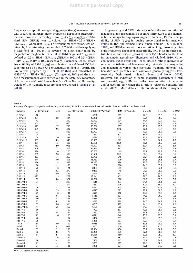
Table 2Summary of magnetic properties and mean grain size (Mz) for bulk river sediment, loess soil, aeolian dust and Taklimakan desert sand.
Samples v (10�8m3/kg) vfd% vARM (10�8m3/kg) SIRM (10�6Am2/kg) HIRM (10�6Am2/kg) S�100 (%) S�300 (%) U (Mz)
CJ-SPM-1 18 – 87 4700 307 72.0 93.5 3.5CJ-SPM-2 101 0.8 424 47,250 616 72.4 98.7 5.0CJ-SPM-3 43 – 260 12,592 924 74.7 92.7 3.9CJ-SPM-4 165 1.7 660 57,272 1050 75.4 98.2 4.2CJ-SPM-5 123 2.7 738 53,780 1337 73.2 97.5 6.3CJ-SPM-6 133 2.9 597 55,752 2888 72.4 94.8 5.7CJ-SPM-7 93 – 882 40,723 93 73.8 99.8 7.8CJ-SPM-8 24 – 396 8262 107 86.7 98.7 –CJ-SPM-9 54 2.0 388 9794 568 82.3 94.2 7.5CJ-SPM-10 103 4.5 549 18,887 619 80.8 96.7 7.7CJ-FP-1 157 1.3 402 48,188 2399 75.4 95.0 3.8CJ-FP-2 352 2.0 981 74,997 1517 83.7 98.0 5.3CJ-FP-3 306 1.7 502 69,525 1732 76.0 97.5 5.3CJ-FP-4 124 1.0 226 15,002 49 86.7 99.7 3.3CJ-FP-5 209 2.6 582 59,596 2545 80.6 95.7 3.7CJ-FP-6 103 1.4 260 16,789 648 81.7 96.1 3.3CJ-FP-7 144 0.9 405 38,363 479 84.1 98.8 3.7CJ-FP-8 136 1.8 537 41,235 1184 80.5 97.1 7.2CJ-FP-9 10 – 39 1292 210 74.0 83.7 3.2CJ-FP-10 76 1.6 121 8397 665 80.5 92.1 3.8CJ-FP-11 58 3.2 270 9269 45 91.6 99.5 7.6CJ-FP-13 33 2.9 255 5770 311 87.6 94.6 7.3CJ-FP-12 123 1.5 709 28,041 465 89.5 98.3 7.9CJ-FP-14 55 3.4 327 12,732 810 80.5 93.6 5.3HH-SPM-1 31 1.1 218 4518 493 84.4 89.1 7.5HH-SPM-2 27 1.2 202 4632 476 82.4 89.7 6.0HH-SPM-3 26 – 173 4225 368 79.5 91.3 5.4HH-SPM-4 28 2.9 129 4677 525 77.7 88.8 6.7HH-SPM-5 27 1.6 131 4573 318 74.9 93.0 6.7HH-SPM-6 32 3.4 182 5116 467 74.2 90.9 7.1HH-SPM-7 40 7.2 236 5486 416 80.2 92.4 6.2HH-SPM-8 32 5.1 154 5093 298 74.5 94.2 6.8HH-SPM-9 55 6.6 518 6285 417 74.6 93.4 7.8HH-SPM-10 47 6.6 467 6179 505 74.6 91.8 7.6HH-FP-1 56 1.7 69 7322 317 73.5 95.7 3.2HH-FP-2 54 2.4 254 7837 494 76.1 93.7 5.8HH-FP-3 23 1.6 96 4621 348 75.8 92.5 5.1HH-FP-4 26 – 107 4452 291 78.8 93.5 4.8HH-FP-5 38 – 71 5266 267 77.8 94.9 3.7Soil-1 84 9.9 709 9518 458 80.8 95.2 6.7Soil-2 83 9.2 658 9062 406 79.3 95.5 4.7Dust-1 83 2.1 283 12,864 490 85.7 96.2 5.9Dust-2 82 3.5 179 13,298 535 82.4 96.0 5.7Dust-3 84 2.1 182 14,036 580 82.5 95.9 5.9Desert-1 22 1.6 37 3814 381 71.4 90.0 7.3Desert-2 16 – 28 2406 383 60.7 84.1 7.2Desert-3 21 – 23 3253 307 71.6 90.6 6.8Desert-4 21 1.3 21 3378 274 72.1 91.9 7.1
Note: ‘‘–’’ means no determination.
C. Li et al. / Journal of Asian Earth Sciences 45 (2012) 190–200 193
Author's personal copy
parameters are referred to Thompson and Oldfield (1986), Evansand Heller (2003) and Liu et al. (2007b).
4. Results
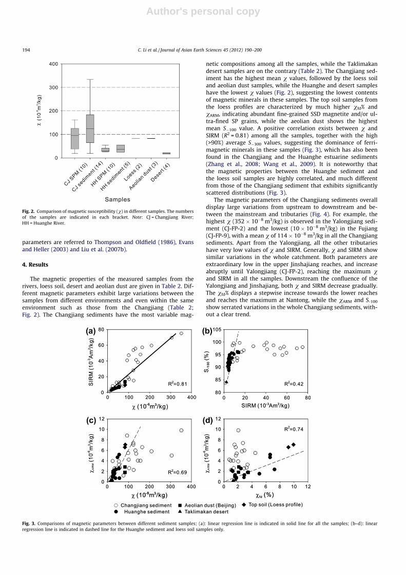
The magnetic properties of the measured samples from therivers, loess soil, desert and aeolian dust are given in Table 2. Dif-ferent magnetic parameters exhibit large variations between thesamples from different environments and even within the sameenvironment such as those from the Changjiang (Table 2;Fig. 2). The Changjiang sediments have the most variable mag-
netic compositions among all the samples, while the Taklimakandesert samples are on the contrary (Table 2). The Changjiang sed-iment has the highest mean v values, followed by the loess soiland aeolian dust samples, while the Huanghe and desert sampleshave the lowest v values (Fig. 2), suggesting the lowest contentsof magnetic minerals in these samples. The top soil samples fromthe loess profiles are characterized by much higher vfd% andvARM, indicating abundant fine-grained SSD magnetite and/or ul-tra-fined SP grains, while the aeolian dust shows the highestmean S�100 value. A positive correlation exists between v andSIRM (R2 = 0.81) among all the samples, together with the high(>90%) average S�300 values, suggesting the dominance of ferri-magnetic minerals in these samples (Fig. 3), which has also beenfound in the Changjiang and the Huanghe estuarine sediments(Zhang et al., 2008; Wang et al., 2009). It is noteworthy thatthe magnetic properties between the Huanghe sediment andthe loess soil samples are highly correlated, and much differentfrom those of the Changjiang sediment that exhibits significantlyscattered distributions (Fig. 3).
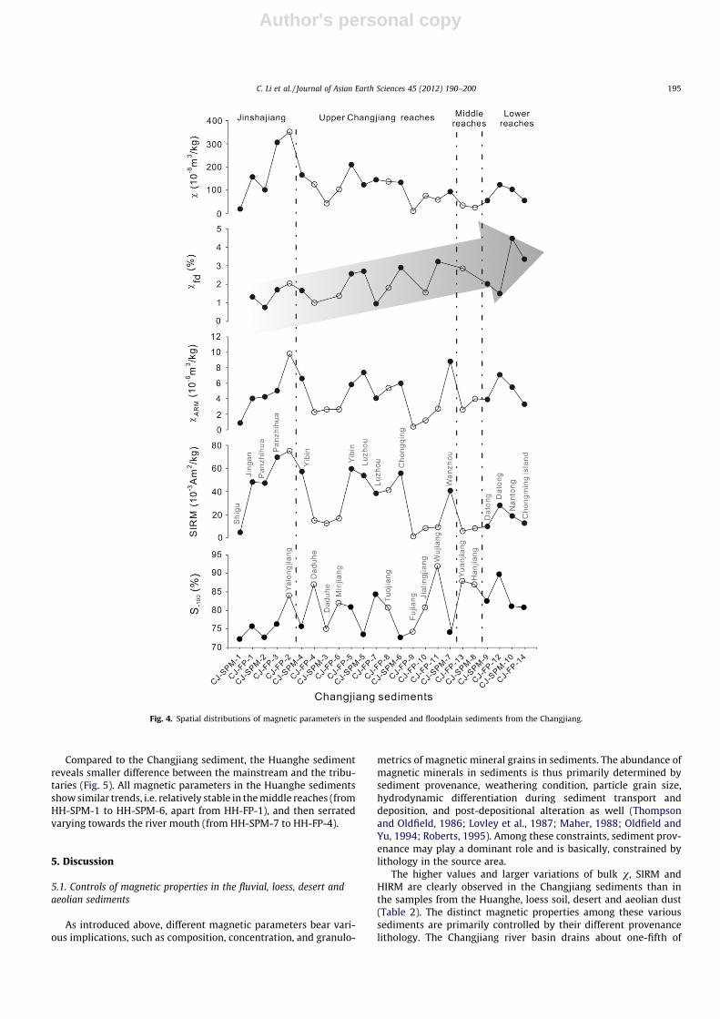
The magnetic parameters of the Changjiang sediments overalldisplay large variations from upstream to downstream and be-tween the mainstream and tributaries (Fig. 4). For example, thehighest v (352 � 10�8 m3/kg) is observed in the Yalongjiang sedi-ment (CJ-FP-2) and the lowest (10 � 10�8 m3/kg) in the Fujiang(CJ-FP-9), with a mean v of 114 � 10�8 m3/kg in all the Changjiangsediments. Apart from the Yalongjiang, all the other tributarieshave very low values of v and SIRM. Generally, v and SIRM showsimilar variations in the whole catchment. Both parameters areextraordinary low in the upper Jinshajiang reaches, and increaseabruptly until Yalongjiang (CJ-FP-2), reaching the maximum vand SIRM in all the samples. Downstream the confluence of theYalongjiang and Jinshajiang, both v and SIRM decrease gradually.The vfd% displays a stepwise increase towards the lower reachesand reaches the maximum at Nantong, while the vARM and S-100
show serrated variations in the whole Changjiang sediments, with-out a clear trend.
Fig. 2. Comparison of magnetic susceptibility (v) in different samples. The numbersof the samples are indicated in each bracket. Note: CJ = Changjiang River;HH = Huanghe River.
Fig. 3. Comparisons of magnetic parameters between different sediment samples; (a): linear regression line is indicated in solid line for all the samples; (b–d): linearregression line is indicated in dashed line for the Huanghe sediment and loess soil samples only.
194 C. Li et al. / Journal of Asian Earth Sciences 45 (2012) 190–200
Author's personal copy
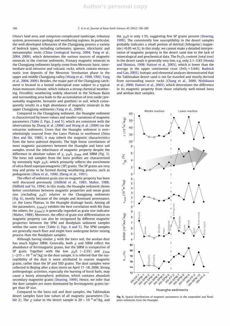
Compared to the Changjiang sediment, the Huanghe sedimentreveals smaller difference between the mainstream and the tribu-taries (Fig. 5). All magnetic parameters in the Huanghe sedimentsshow similar trends, i.e. relatively stable in the middle reaches (fromHH-SPM-1 to HH-SPM-6, apart from HH-FP-1), and then serratedvarying towards the river mouth (from HH-SPM-7 to HH-FP-4).
5. Discussion
5.1. Controls of magnetic properties in the fluvial, loess, desert andaeolian sediments
As introduced above, different magnetic parameters bear vari-ous implications, such as composition, concentration, and granulo-
metrics of magnetic mineral grains in sediments. The abundance ofmagnetic minerals in sediments is thus primarily determined bysediment provenance, weathering condition, particle grain size,hydrodynamic differentiation during sediment transport anddeposition, and post-depositional alteration as well (Thompsonand Oldfield, 1986; Lovley et al., 1987; Maher, 1988; Oldfield andYu, 1994; Roberts, 1995). Among these constraints, sediment prov-enance may play a dominant role and is basically, constrained bylithology in the source area.
The higher values and larger variations of bulk v, SIRM andHIRM are clearly observed in the Changjiang sediments than inthe samples from the Huanghe, loess soil, desert and aeolian dust(Table 2). The distinct magnetic properties among these varioussediments are primarily controlled by their different provenancelithology. The Changjiang river basin drains about one-fifth of
Fig. 4. Spatial distributions of magnetic parameters in the suspended and floodplain sediments from the Changjiang.
C. Li et al. / Journal of Asian Earth Sciences 45 (2012) 190–200 195
Author's personal copy
China’s land area, and comprises complicated landscape, tributarysystem, provenance geology and weathering regimes. In particular,the well-developed tributaries of the Changjiang possess a varietyof bedrock types, including carbonates, igneous, siliciclastic andmetamorphic rocks (China Geological Survey, 2004; Yang et al.,2004, 2009), which determines the various sources of magneticminerals in the riverine sediments. Primary magnetic minerals inthe Changjiang sediments largely come from Mesozoic basic, inter-mediate-acid intrusive and volcanic rocks, which contain metaso-matic iron deposits of the Mesozoic Yenshanian phase in theupper and middle Changjiang valley (Wang et al., 1990, 1992; Yanget al., 2004, 2009). Besides, the major part of the Changjiang catch-ment is located in a humid subtropical zone subject to a typicalAsian monsoon climate, which induces a strong chemical weather-ing. Ferrallitic weathering widely observed in the Sichuan Basinand surrounding area leads to the accumulation of iron oxide (pre-sumably magnetite, hematite and goethite) in soil, which conse-quently results in a high abundance of magnetic minerals in theupper Changjiang sediments (Yang et al., 2009).
Compared to the Changjiang sediment, the Huanghe sedimentis characterized by lower values and smaller variations of magneticparameters (Table 2; Figs. 2 and 5), which are consistent with theobservations by Zhang et al. (2008) and Wang et al. (2009) on theestuarine sediments. Given that the Huanghe sediment is over-whelmingly sourced from the Loess Plateau in northwest China(Ren and Shi, 1986), it may inherit the magnetic characteristicsfrom the loess–paleosol deposits. The high linear correlations ofmost magnetic parameters between the Huanghe and loess soilsamples reveal the inheritance of magnetic property despite thedifference in absolute values of v, vfd%, vARM and SIRM (Fig. 3).The loess soil samples from the loess profiles are characterizedby extremely high vfd%, which primarily reflects the enrichmentof ultra-fined superparamagnetic (SP) grains. The SP grains are verytiny and prone to be formed during weathering process, such aspedogenesis (Zhou et al., 1990; Zheng et al., 1991).
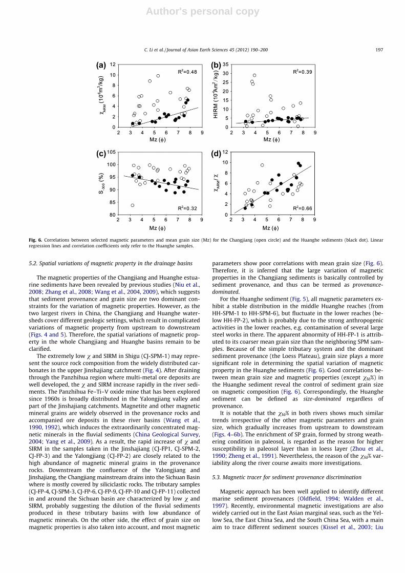
The effect of sediment grain size on magnetic property has beenwell discussed previously (Oldfield et al., 1985; Maher, 1988;Oldfield and Yu, 1994). In this study, the Huanghe sediment showsbetter correlations between magnetic properties and mean grainsize (excluding vfd%) relative to the Changjiang sediments(Fig. 6), mostly because of the simple and dominant provenance,i.e. the Loess Plateau, in the Huanghe drainage basin. Among allthe parameters, vARM/v exhibits the best correlation with Mz thanthe others, for vARM/v is generally regarded as grain size indicator(Maher, 1988). Moreover, the effect of grain size differentiation onmagnetic property can also be recognized by different magneticproperties between the SPM and floodplain sediment sampleswithin the same river (Table 2; Figs. 4 and 5). The SPM samplesare generally much finer and might have undergone better mixingprocess than the floodplain samples.
Although having similar v with the loess soil, the aeolian dusthas much higher SIRM. Generally, both v and SIRM reflect theabundance of ferrimagnetic grains, but the SIRM is irrespective ofSP grain. Together with the low vfd% (�2.5%) and vARM
(�215 � 10�8 m3/kg) in the dust sample, it is referred that the sus-ceptibility of the dust is more attributed to coarser magneticgrains, rather than the SP and SSD grains. The dust samples werecollected in Beijing after a dust storm on April 17–18, 2006. Stronganthropologic activities, especially the burning of fossil fuels, maycause a heavy atmospheric pollution, which contains abundantsecondary magnetite grains (Dearing, 1999). Hence, we infer thatthe dust samples are more dominated by ferrimagnetic grains lar-ger than SP size.
Compared to the loess soil and dust samples, the Taklimakandesert samples have low values of all magnetic parameters (Ta-ble 2). The v value in the desert sample is 20 � 10�8 m3/kg, and
the vfd% is only 1.5%, suggesting few SP grains present (Dearing,1999). The consistently low susceptibility in the desert samplesprobably indicates a small portion of detrital (lithogenic) magne-tite (<0.05 wt.%). In this study, we cannot make a detailed interpre-tation of magnetic property in the desert sand due to the lack ofmineralogical and geochemical data. The Fe2O3 content (total iron)in the desert sands is generally very low, e.g. only 2.1–3.8% (Hondaand Shimizu, 1998; Hattori et al., 2003), which is lower than theaverage in the upper continental crust (FeOT = 5.04%; Rudnickand Gao, 2003). Isotopic and elemental analyses demonstrated thatthe Taklimakan desert sand is not far-traveled and mostly derivedfrom surrounding source rocks (Chang et al., 2000; Nishikawaet al., 2000; Hattori et al., 2003), which determines the differencein its magnetic property from those relatively well-mixed loessand aeolian dust samples.
Fig. 5. Spatial distributions of magnetic parameters in the suspended and flood-plain sediments from the Huanghe.
196 C. Li et al. / Journal of Asian Earth Sciences 45 (2012) 190–200
Author's personal copy
5.2. Spatial variations of magnetic property in the drainage basins
The magnetic properties of the Changjiang and Huanghe estua-rine sediments have been revealed by previous studies (Niu et al.,2008; Zhang et al., 2008; Wang et al., 2004, 2009), which suggeststhat sediment provenance and grain size are two dominant con-straints for the variation of magnetic properties. However, as thetwo largest rivers in China, the Changjiang and Huanghe water-sheds cover different geologic settings, which result in complicatedvariations of magnetic property from upstream to downstream(Figs. 4 and 5). Therefore, the spatial variations of magnetic prop-erty in the whole Changjiang and Huanghe basins remain to beclarified.
The extremely low v and SIRM in Shigu (CJ-SPM-1) may repre-sent the source rock composition from the widely distributed car-bonates in the upper Jinshajiang catchment (Fig. 4). After drainingthrough the Panzhihua region where multi-metal ore deposits arewell developed, the v and SIRM increase rapidly in the river sedi-ments. The Panzhihua Fe–Ti–V oxide mine that has been exploredsince 1960s is broadly distributed in the Yalongjiang valley andpart of the Jinshajiang catchments. Magnetite and other magneticmineral grains are widely observed in the provenance rocks andaccompanied ore deposits in these river basins (Wang et al.,1990, 1992), which induces the extraordinarily concentrated mag-netic minerals in the fluvial sediments (China Geological Survey,2004; Yang et al., 2009). As a result, the rapid increase of v andSIRM in the samples taken in the Jinshajiang (CJ-FP1, CJ-SPM-2,CJ-FP-3) and the Yalongjiang (CJ-FP-2) are closely related to thehigh abundance of magnetic mineral grains in the provenancerocks. Downstream the confluence of the Yalongjiang andJinshajiang, the Changjiang mainstream drains into the Sichuan Basinwhere is mostly covered by siliciclastic rocks. The tributary samples(CJ-FP-4, CJ-SPM-3, CJ-FP-6, CJ-FP-9, CJ-FP-10 and CJ-FP-11) collectedin and around the Sichuan basin are characterized by low v andSIRM, probably suggesting the dilution of the fluvial sedimentsproduced in these tributary basins with low abundance ofmagnetic minerals. On the other side, the effect of grain size onmagnetic properties is also taken into account, and most magnetic
parameters show poor correlations with mean grain size (Fig. 6).Therefore, it is inferred that the large variation of magneticproperties in the Changjiang sediments is basically controlled bysediment provenance, and thus can be termed as provenance-dominated.
For the Huanghe sediment (Fig. 5), all magnetic parameters ex-hibit a stable distribution in the middle Huanghe reaches (fromHH-SPM-1 to HH-SPM-6), but fluctuate in the lower reaches (be-low HH-FP-2), which is probably due to the strong anthropogenicactivities in the lower reaches, e.g. contamination of several largesteel works in there. The apparent abnormity of HH-FP-1 is attrib-uted to its coarser mean grain size than the neighboring SPM sam-ples. Because of the simple tributary system and the dominantsediment provenance (the Loess Plateau), grain size plays a moresignificant role in determining the spatial variation of magneticproperty in the Huanghe sediments (Fig. 6). Good correlations be-tween mean grain size and magnetic properties (except vfd%) inthe Huanghe sediment reveal the control of sediment grain sizeon magnetic composition (Fig. 6). Correspondingly, the Huanghesediment can be defined as size-dominated regardless ofprovenance.
It is notable that the vfd% in both rivers shows much similartrends irrespective of the other magnetic parameters and grainsize, which gradually increases from upstream to downstream(Figs. 4–6b). The enrichment of SP grain, formed by strong weath-ering condition in paleosol, is regarded as the reason for highersusceptibility in paleosol layer than in loess layer (Zhou et al.,1990; Zheng et al., 1991). Nevertheless, the reason of the vfd% var-iability along the river course awaits more investigations.
5.3. Magnetic tracer for sediment provenance discrimination
Magnetic approach has been well applied to identify differentmarine sediment provenances (Oldfield, 1994; Walden et al.,1997). Recently, environmental magnetic investigations are alsowidely carried out in the East Asian marginal seas, such as the Yel-low Sea, the East China Sea, and the South China Sea, with a mainaim to trace different sediment sources (Kissel et al., 2003; Liu
Fig. 6. Correlations between selected magnetic parameters and mean grain size (Mz) for the Changjiang (open circle) and the Huanghe sediments (black dot). Linearregression lines and correlation coefficients only refer to the Huanghe samples.
C. Li et al. / Journal of Asian Earth Sciences 45 (2012) 190–200 197
Author's personal copy
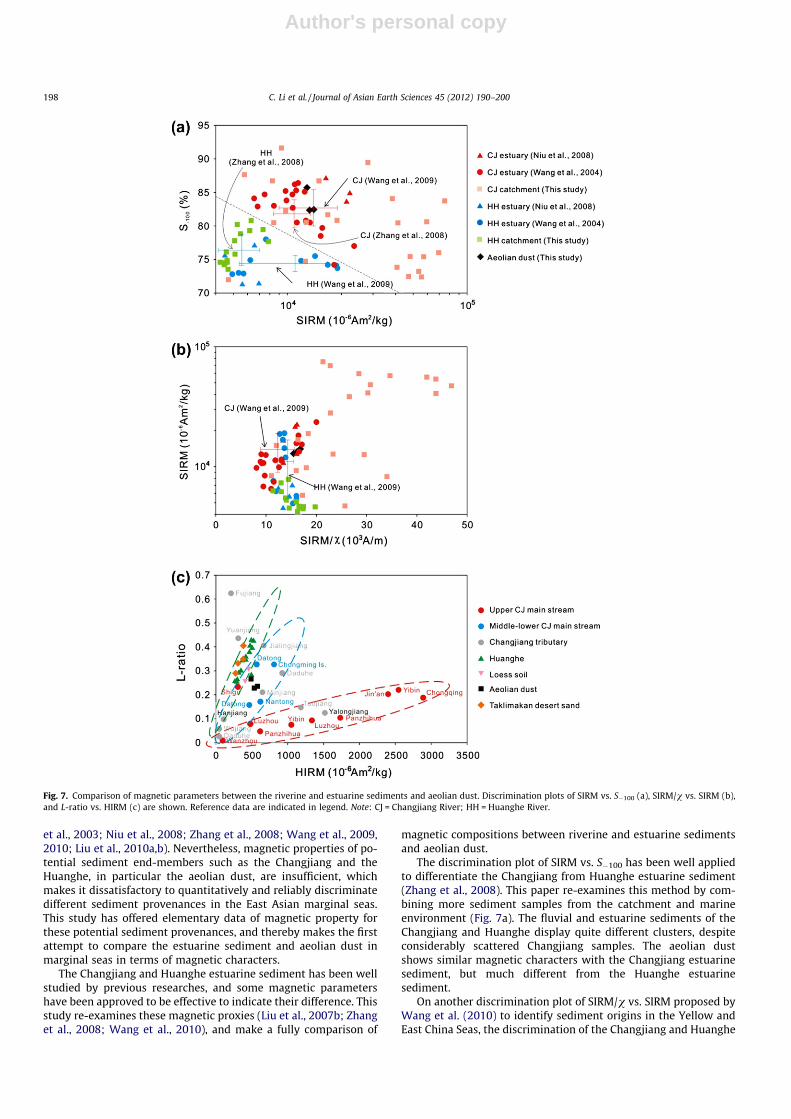
et al., 2003; Niu et al., 2008; Zhang et al., 2008; Wang et al., 2009,2010; Liu et al., 2010a,b). Nevertheless, magnetic properties of po-tential sediment end-members such as the Changjiang and theHuanghe, in particular the aeolian dust, are insufficient, whichmakes it dissatisfactory to quantitatively and reliably discriminatedifferent sediment provenances in the East Asian marginal seas.This study has offered elementary data of magnetic property forthese potential sediment provenances, and thereby makes the firstattempt to compare the estuarine sediment and aeolian dust inmarginal seas in terms of magnetic characters.
The Changjiang and Huanghe estuarine sediment has been wellstudied by previous researches, and some magnetic parametershave been approved to be effective to indicate their difference. Thisstudy re-examines these magnetic proxies (Liu et al., 2007b; Zhanget al., 2008; Wang et al., 2010), and make a fully comparison of
magnetic compositions between riverine and estuarine sedimentsand aeolian dust.
The discrimination plot of SIRM vs. S�100 has been well appliedto differentiate the Changjiang from Huanghe estuarine sediment(Zhang et al., 2008). This paper re-examines this method by com-bining more sediment samples from the catchment and marineenvironment (Fig. 7a). The fluvial and estuarine sediments of theChangjiang and Huanghe display quite different clusters, despiteconsiderably scattered Changjiang samples. The aeolian dustshows similar magnetic characters with the Changjiang estuarinesediment, but much different from the Huanghe estuarinesediment.
On another discrimination plot of SIRM/v vs. SIRM proposed byWang et al. (2010) to identify sediment origins in the Yellow andEast China Seas, the discrimination of the Changjiang and Huanghe
Fig. 7. Comparison of magnetic parameters between the riverine and estuarine sediments and aeolian dust. Discrimination plots of SIRM vs. S�100 (a), SIRM/v vs. SIRM (b),and L-ratio vs. HIRM (c) are shown. Reference data are indicated in legend. Note: CJ = Changjiang River; HH = Huanghe River.
198 C. Li et al. / Journal of Asian Earth Sciences 45 (2012) 190–200
Author's personal copy
sediments is not clear (Fig. 7b). The Huanghe and Changjiang estu-arine sediments (Wang et al., 2004, 2009) are largely mixed andoverlapped in this discrimination plot (Wang et al., 2004; Niuet al., 2008; this study), which makes it impossible to reliably dis-criminate both sediments into the sea. This uncertainty may arisefrom sample inhomogeneity (e.g. grain size differentiation) and/ordifferent analytical conditions, which is beyond the scope of thisresearch. Overall, the aeolian dust exhibits closer magnetic compo-sitions with the Changjiang sediments in these two discriminationplots (Fig. 7a and b).
The L-ratio is supposed to be sensitive for tracing hematite/goe-thite (Liu et al., 2007b). In the plot of L-ratio vs. HIRM (Fig. 7c), theHuanghe sediment and Taklimakan desert sand are closely clus-tered, mid-lower Changjiang mainstream sediments and aeoliandust samples clustered, while the upper Changjiang mainstreamsediments display a clearly different group with the other sedi-ments. In comparison, the sediments from the tributaries of theChangjiang show much scattered variations in this plot, probablysuggesting complex controls of various source rocks on magneticproperty in the tributary sediments. Nevertheless, the good linearcorrelation between L-ratio and HIRM in the mainstream sedi-ments indicates that the HIRM is basically controlled by the coer-civity rather than by antiferromagnetic mineral concentration (Liuet al., 2007b). Thereby, the samples that show different linercorrelations may have different hematite/goethite compositions,diagnostic of variable sediment sources. In other words, the plotof L-ratio vs. HIRM can be considered to distinctly discriminatethe sediments from different rivers and from different reacheswithin one river.
As discussed above, the fluvial sediments (e.g. Yalongjiang andTuojiang rivers) from Panzhihua region where multi-metal (Fe–Ti–V oxides) ore deposits are well developed, overall control themagnetic composition of the upper Changjiang mainstream sedi-ment. The good linear correlation of L-ratio with HIRM (Fig. 7c) be-tween the upper Changjiang mainstream and the Yalongjiang andTuojiang tributary sediments further confirms the significant con-tribution of Panzhihua iron ore deposits to the magnetic propertyof the Changjiang sediments.
Overall, despite the feasibility of discriminating the Changjiangsediment, Huanghe sediment and aeolian dust based on their dis-tinct magnetic properties, all comparisons and discriminationsproposed above are only based on the samples taken on land.While using these discrimination approaches to identify the aeo-lian dust and fluvial sediments in the East Asian marginal seas,we have to assume that these terrigenous sediments undergo weakor no alteration during and after entering into the sea. Neverthe-less, depositional and post-depositional diagenetic alterations canform pyrite, pyrrhotite or greigite due to magnetite reduction pro-cess in marine environments (Lovley et al., 1987). Significant par-titioning and dissolution of specific magnetic minerals undermarine environments in the East China Sea have been reportedpreviously (Roberts, 1995; Liu et al., 2004; Zheng et al., 2010).Therefore, a better understanding of the influence of hydrody-namic sorting, diagenetic process and redox reaction on deposi-tional magnetic minerals appear to be a prerequisite for morereliably identifying the origins of these terrigenous sediments inthe marginal seas.
6. Conclusions
Typical magnetic properties of the sediment samples from di-verse environments including the rivers, top soil from the loessprofile, desert and aeolian dust were investigated in this contribu-tion. In particular, the suspended and floodplain sediments fromthe mainstream and main tributaries of the Changjiang and Huan-
ghe rivers were comparatively studied to examine the spatial var-iation of magnetic compositions and their constraints. TheChangjiang sediment is characterized by the highest magneticmineral concentration and the largest variations for most magneticparameters, while the Huanghe sediment has much lower contentsof magnetic minerals. The loess soil has the highest vfd%, indicativeof the enrichment of finer SP grains. The aeolian dust displays sim-ilar v with the soil sample, but is higher in SIRM and lower in vARM,possibly indicating dominance by coarser ferrimagnetic grains lar-ger than SP and SSD size. The desert sample has the lowest valuesof each magnetic parameter.
The rapid increase of v and SIRM in some Jinshajiang and Yal-ongjiang samples is primarily caused by high abundance of mag-netic minerals in their provenance rocks. Downstream theconfluence of the Jinshajiang and Yalongjiang, the gradual decreaseof v and SIRM in the river sediments is probably due to the dilutionby many tributaries with low abundance of magnetic minerals.Comparatively, most magnetic parameters in the Huanghe sedi-ments are stable in the middle reaches but show large fluctuationsin the lower reaches, probably resulting from grain size variationbetween the samples and strong anthropogenic activities in thelower basin. Overall, magnetic property in the Changjiang sedi-ment is mainly constrained by its diverse lithology in the basin(provenance-dominated), while magnetic property in the Huanghesediment is highly related to sediment grain size because of thesimple sediment provenance (size-dominated). It is interesting tonote that vfd% may indicate grain size fractionation in a river basin.
Based upon the discrimination plot of SIRM vs. S�100, the Chang-jiang sediment, Huanghe sediment and aeolian dust can be clearlydiscriminated, and the plot of L-ratio vs. HIRM is sensitive for dif-ferentiating the mainstream sediments from different reaches ofthe Changjiang. Overall, magnetic method sheds a new light onthe possibility of identifying the sediment origins in East Chinamarginal seas, with great caution of hydrodynamic differentiationand diagenetic alterations of terrigenous magnetic minerals inmarine environment.
Acknowledgements
This work was supported by research funds awarded by the Na-tional Natural Science Foundation of China (Grant No. 41076018,40830107) and the National Basic Research Program of China(2007CB815906). We thank Youbin Sun and Yan Zheng for provid-ing the desert and aeolian dust samples respectively. Thanks go toChi-An Huh and the anonymous reviewers for their constructivecomments.
References
Andreae, M.O., Rosenfeld, D., 2008. Aerosol–cloud–precipitation interactions. Part 1.The nature and sources of cloud-active aerosols. Earth-Science Reviews 89, 13–41.
Bloemendal, J., King, J.W., Hall, F.R., Doh, S.-J., 1992. Rock magnetism of LateNeogene and Pleistocene deep-sea sediments: Relationship to sediment source,diagenetic processes, and sediment lithology. Journal of Geophysical Research97, 4361–4375.
Bory, A.J.-M., Biscaye, P.E., Grousset, F.E., 2003. Two distinct seasonal Asian sourceregions for mineral dust deposited in Greenland (North GRIP). GeophysicalResearch Letters 30, 1167.
Chang, Q., Mishima, T., Yabuki, S., Takahashi, Y., Shimizu, H., 2000. Sr and Nd isotoperatios and REE abundances of moraines in the mountain areas surrounding theTaklimakan Desert, NW China. Geochemical Journal 34, 407–427.
Chen, J.Y., Zhu, H.F., Dong, Y.F., Sun, J.M., 1985. Development of the ChangjiangEstuary and its submerged delta. Continental Shelf Research 4, 47–56.
China Geological Survey, 2004. Geological Map of China (1:2500,000). ChinaGeological Map Press, Beijing.
Dearing, J.A., 1999. Dearing, Environmental Magnetic Susceptibility: Using the MS2System, second ed. Chi Publishing, Kenilworth.
Duce, R.A., Unni, C.K., Ray, B.J., Prospero, J.M., Merrill, J.T., 1980. Long-rangeatmospheric transport of soil dust from Asia to the tropical North Pacific:temporal variability. Science 209, 1522–1524.
C. Li et al. / Journal of Asian Earth Sciences 45 (2012) 190–200 199
Author's personal copy
Engelbrecht, J.P., Derbyshire, E., 2010. Airborne mineral dust. Elements 6, 241–246.Evans, M.E., Heller, F., 2003. Environmental Magnetism: Principles and Applications
of Environmagnetics. Academic Press, California.Hattori, Y., Suzuki, K., Honda, M., Shimizu, H., 2003. Re-Os systematics of the
Taklimakan Desert sands, moraines and river sediments around the TaklimakanDesert, and of Tibetan soils. Geochimica et Cosmochimica Acta 67, 1195–1205.
Heller, F., Liu, T.S., 1986. Palaeoclimatic and sedimentary history from magneticsusceptibility of loess in China. Geophysical Research Letters 13, 1169–1172.
Honda, M., Shimizu, H., 1998. Geochemical, mineralogical and sedimentologicalstudies on the Taklimakan Desert sands. Sedimentology 45, 1125–1143.
Horng, C.S., Huh, C.A., 2011. Magnetic properties as tracers for source-to-sinkdispersal of sediments: a case study in the Taiwan Strait. Earth and PlanetaryScience Letters 309, 141–152.
Hunt, A., Jones, J., Oldfield, F., 1984. Magnetic measurements and heavy metals inatmospheric particulates of anthropogenic origin. Science of the TotalEnvironment 33, 129–139.
Jiang, F., Fu, J., Wang, S., Sun, D., Zhao, Z., 2007. Formation of the Yellow River,inferred from loess–paleosol sequence in Mangshan and lacustrine sedimentsin Sanmen Gorge, China. Quaternary International 175, 62–70.
Jickells, T.D., An, Z.S., Andersen, K.K., Baker, A.R., Bergametti, G., Brooks, N., Cao, J.J.,Boyd, P.W., Duce, R.A., Hunter, K.A., Kawahata, H., Kubilay, N., laRoche, J., Liss,P.S., Mahowald, N., Prospero, J.M., Ridgwell, A.J., Tegen, I., Torres, R., 2005.Global iron connections between desert dust, ocean biogeochemistry, andclimate. Science 308, 67–71.
Kissel, C., Laj, C., Clemens, S., Solheid, P., 2003. Magnetic signature of environmentalchanges in the last 1.2 My at ODP Site1146, South China Sea. Marine Geology201, 119–132.
Kukla, G., An, Z.S., 1989. Loess stratigraphy in central China. PalaeogeographyPalaeoclimatology Palaeoecology 72, 203–225.
Li, F., Li, G., Ji, J., 2011. Increasing magnetic susceptibility of the suspended particlesin Yangtze River and possible contribution of fly ash. Catena 87, 141–146.
Liu, J., Zhu, R.X., Li, G.X., 2003. Rock magnetic properties of the fine-grainedsediment on the outer shelf of the East China Sea: implication for provenance.Marine Geology 193, 195–206.
Liu, J., Zhu, R.X., Roberts, A.P., Li, S.Q., Chang, J.H., 2004. High-resolution analysis ofearly diagenetic effects on magnetic minerals in post-middle-Holocenecontinental shelf sediments from the Korea Strait. Journal of GeophysicalResearch 109, B03103.
Liu, J.G., Chen, Z., Chen, M.H., Yan, W., Xiang, R., Tang, X.Z., 2010a. Magneticsusceptibility variations and provenance of surface sediments in the SouthChina Sea. Sedimentary Geology 230, 77–85.
Liu, Q.S., Deng, C.L., Torrent, J., Zhu, R.X., 2007a. Review of recent developments inmineral magnetism of the Chinese loess. Quaternary Science Reviews 26, 368–385.
Liu, Q.S., Roberts, A.P., Torrent, J., Horng, C.S., Larrasoaña, J.C., 2007b. What do theHIRM and S-ratio really measure in environmental magnetism? GeochemistryGeophysics Geosystems 8, Q09011.
Liu, S.M., Zhang, W.G., He, Q., Li, D.J., Liu, H., Yu, L.Z., 2010b. Magnetic properties ofEast China Sea shelf sediments off the Yangtze Estuary: Influence of provenanceand particle size. Geomorphology 119, 212–220.
Liu, T.S., 1985. Loess and the Environment. China Ocean Press, Beijing.Lovley, D.R., Stolz, J.F., Nord, J.L., Phillips, E.J.P., 1987. Anaerobic production of mag-
netite by a dissimilatory iron-reducing microorganism. Nature 330, 252–254.Maher, B.A., 1988. Magnetic properties of some synthetic sub-micron magnetites.
Geophysical Journal 94, 83–96.Maher, B.A., Taylor, R.M., 1988. Formation of ultrafine-grained magnetite in soils.
Nature 336, 368–370.Maher, B.A., Thompson, R., 1991. Mineral magnetic record of the Chinese loess and
paleosols. Geology 19, 3–6.Maher, B.A., Prospero, J.M., Mackie, D., Gaiero, D., Hesse, P.P., Balkanski, Y., 2010.
Global connections between aeolian dust, climate and ocean biogeochemistryat the present day and at the last glacial maximum. Earth-Science Reviews 99,61–97.
Martin, J.H., 1990. Glacial–interglacial CO2 change: the iron hypothesis.Paleoceanography 5, 1–13.
Milliman, J.D., Meade, R.H., 1983. World-wide delivery of river sediments to theoceans. Journal of Geology 91, 1–21.
Nishikawa, M., Hao, Q., Morita, M., 2000. Preparation and evaluation of certifiedreference materials for Asian mineral dust. Global Environment Research 4,103–113.
Niu, J.L., Yang, Z.S., Li, Y.H., Qiao, S.Q., 2008. The characteristics of the environmentalmagnetism in sediment from the river mouths of the Changjiang River and theHuanghe River and their comparison study. Marine Sciences 32, 24–30 (inChinese with English abstract).
Oldfield, F., Maher, B.A., Donoghue, J., Pierce, J., 1985. Particle size related, mineralmagnetic source sediment linkages in the Rhode River catchment, Maryland.Journal of the Geological Society 142, 1035–1046.
Oldfield, F., 1994. Toward the discrimination of fine-grained ferrimagnets bymagnetic measurements in lake and near shore marine sediments. Journal ofGeophysical Research 99, 9045–9050.
Oldfield, F., Yu, L.Z., 1994. The influence of particle size variations on the magneticproperties of sediments from the north-eastern Irish Sea. Sedimentology 41,1093–1108.
Ren, M.E., Shi, Y.L., 1986. Sediment discharge of the Yellow River (China) and itseffect on the sedimentation of the Bohai and the Yellow Sea. Continental ShelfResearch 6, 785–810.
Roberts, A.P., 1995. Magnetic properties of sedimentary greigite (Fe3S4). Earth andPlanetary Science Letters 134, 227–236.
Roberts, A.P., 2007. Environmental magnetism, paleomagnetic applications. In:Gubbins, D., Herrero-Bervera, E. (Eds.), Encylopedia of Geomagnetism andPaleomagnetism, Encyclopedia of Earth Science Series. Springer, Dordrecht, pp.256–261.
Rudnick, R., Gao, S., 2003. Composition of the continental crust. In: Rudnick, R.L.(Ed.), The Crust. In: Holland, H.D., Turekian, K.K. (Eds.), Treatise onGeochemistry. Elsevier–Pergamon, Oxford, pp. 1–64.
Scoullos, M., Oldfield, F., Thompson, R., 1979. Magnetic monitoring of marineparticulate pollution in the Elefsis Gulf, Greece. Marine Pollution Bulletin 10,287–291.
Sun, Y.B., Wang, X.L., Liu, Q.S., Clemens, S.C., 2010. Impacts of post-depositionalprocesses on rapid monsoon signals recorded by the last glacial loess deposits ofnorthern China. Earth and Planetary Science Letters 29, 171–179.
Tanaka, T.Y., Chiba, M., 2006. A numerical study of the contributions of dust sourceregions to the global dust budget. Global and Planetary Change 52, 88–104.
Taylor, R.M., Maher, B.A., Self, P.G., 1987. Magnetite in soils. I. Synthesis of singledomain and superparamagnetic magnetite. Clay Minerals 22, 411–422.
Thompson, R., Oldfield, F., 1986. Environmental magnetism. George Allen andUnwin, London.
Uno, I., Eguchi, K., Yumimoto, K., Takemura, T., Shimizu, A., Uematsu, M., Liu, Z.,Wang, Z., Hara, Y., Sugimoto, N., 2009. Asian dust transported one full circuitaround the globe. Nature Geoscience 2, 557–560.
Verosub, K.L., Roberts, A.P., 1995. Environmental magnetism: past, present, andfuture. Journal of Geophysical Research 100, 2175–2192.
Walden, J., Slattery, M.C., Burt, T.P., 1997. Use of mineral magnetic measurements tofingerprint suspended sediment sources: approaches and techniques for dataanalysis. Journal of Hydrology 202, 353–372.
Wang, D.Y., Chen, M., Zhang, C.J., 1990. The Fe–Ti accessory minerals in granitoidsand their genetic significance. Journal of Chengdu College of Geology 17, 46–52(in Chinese with English abstract).
Wang, T., Yan, F.M., Yang, C., 1992. Research of main accessory mineral of granitoidsin Tongbaishan–Dabieshan. Geological Laboratory 8, 106–113 (in Chinese withEnglish abstract).
Wang, Y.H., Sheng, H.T., Zhang, W.G., 2004. A Preliminary Comparison of MagneticProperties of Sediments from the Changjiang and the Huanghe Estuaries andtheir controlling factors. Acta Sedimentologica Sinica 22, 658–663 (in Chinesewith English abstract).
Wang, Y.H., Yu, Z.G., Li, G.X., Oguchi, T., He, H.J., Shen, H.T., 2009. Discrimination inmagnetic properties of different-sized sediments from the Changjiang andHuanghe Estuaries of China and its implication for provenance of sediment onthe shelf. Marine Geology 260, 121–129.
Wang, Y.H., Dong, H.L., Li, G.X., Zhang, W.G., Oguchi, T., Bao, M., Jiang, H.C., Bishop,M.E., 2010. Magnetic properties of muddy sediments on the northeasterncontinental shelves of China: implication for provenance and transportation.Marine Geology 274, 107–119.
Yang, S.Y., Li, C.X., Lee, C.B., Na, T.K., 2003. REE geochemistry of suspendedsediments from the rivers around the Yellow Sea and provenance indicators.Chinese Science Bulletin 48, 1135–1139.
Yang, S.Y., Jung, H.S., Li, C.X., 2004. Two unique weathering regimes in theChangjiang and Huanghe drainage basins: geochemical evidence from river.Sedimentary Geology 164, 19–34.
Yang, S.Y., Wang, Z.B., Guo, Y., Li, C.X., Cai, J.G., 2009. Heavy mineral compositions ofthe Changjiang (Yangtze River) sediments and their provenance-tracingimplication. Journal of Asian Earth Sciences 35, 56–65.
Yang, Z.S., Wang, H.J., Saito, Y., Milliman, J.D., Xu, K.H., Qiao, S.Q., Shi, G., 2006. Damimpacts on the Changjiang (Yangtze) River sediment discharge to the sea: thepast 55 years and after the Three Gorges Dam. Water Resources Research 42,W04407.
Yang, S.L., Zhang, J., Xu, X.J., 2007. Influence of the Three Gorges Dam ondownstream delivery of sediment and its environmental implications,Yangtze River. Geophysical Research Letters 34, L10401.
Zhang, W.G., Yu, L.Z., Hutchinson, S.M., 2001. Diagenesis of magnetic minerals in theintertidal sediments of the Yangtze Estuary, China and its environmentalsignificance. Science of the Total Environment 266, 169–175.
Zhang, W.G., Yu, L.Z., 2003. Magnetic properties of tidal flat sediments of theYangtze Estuary and its relationship with particle size. Science in China (SeriesD: Earth Sciences) 46, 954–966.
Zhang, W.G., Yun, Y., Yu, L.Z., 2008. Distinguishing sediments from the Yangtze andYellow Rivers, China: a mineral magnetic approach. The Holocene 18, 1139–1145.
Zhao, X., Roberts, A.P., 2010. How does the Chinese loess become magnetized? Earthand Planetary Science Letters 292, 112–122.
Zheng, H.B., Yu, L.Z., Oldfield, F., Shaw, J., An, Z.S., 1991. The magnetic properties ofparticle-sized samples from the Luochuan loess section: evidence forpedogenesis. Physics of The Earth and Planetary Interiors 68, 250–258.
Zheng, Y., Zhang, S.H., 2008. Magnetic properties of street dust and topsoil in Beijingand its environmental implications. Chinese Science Bulletin 53, 408–417.
Zheng, Y., Kissel, C., Zheng, H.B., Lajand, C., Wang, K., 2010. Sedimentation on theinner shelf of the East China Sea: magnetic properties, diagenesis andpaleoclimate implications. Marine Geology 268, 34–42.
Zhou, L.P., Oldfield, F., Wintle, A.G., Robinson, S.G., Wang, J.T., 1990. Partly pedogenicorigin of magnetic variations in Chinese loess. Nature 346, 737–739.
Zhu, Z., Wu, Z., Liu, S., Di, X., 1980. An Induction to Chinese Desert. Science Press,Beijing, p. 107 (in Chinese).
200 C. Li et al. / Journal of Asian Earth Sciences 45 (2012) 190–200