Embed Size (px)
Citation preview
r
r
u
,.
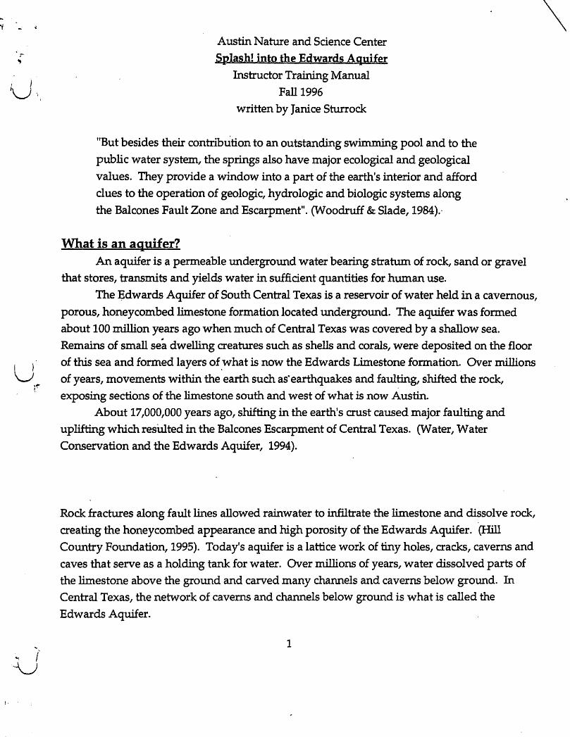
Austin Nature and Science Center Splash! into the Edwards Aquifer
Instructor Training Manual Fall 1996
written by Janice Sturrock
"But besides their contribution to an outstanding swimming pool and to the
public water system, the springs also have major ecological and geological values. They provide a window into a part of the earth's interior and afford clues to the operation of geologic, hydrologic and biologic systems along the Balcones Fault Zone and Escarpment". (Woodruff & Slade,1984).'
What is an aquifer? An aquifer is a permeable underground water bearing stratum of rock, sand or gravel
that stores, transmits and yields water in sufficient quantities for human use.
The Edwards Aquifer of South Central Texas is a reservoir of water held in a cavernous, porous, honeycombed limestone formation located underground. The aquifer was formed about 100 million years ago when much of Central Texas was covered by a shallow sea. Remains of small sea dwelling creatures such as shells and corals, were deposited on the floor of this sea and formed layers of , what is now the Edwards Limestone formation~ Over millions of years, movements within the earth such as· earthquakes and faulting, shifted the rock, exposing sections of the limestone south and west of what is now Austin.
About 17,000,000 years ago, shifting in the earth's crust caused major faulting and uplifting which resUlted in the Balcones Escarpment of Central Texas. (Water, Water Conservation and the Edwards Aquifer, 1994).
Rock fractures along fault lines allowed rainwater to infiltrate the limestone and dissolve rock, creating the honeycombed appearance and high porosity of the Edwards Aquifer. (Hill
Country Foundation, 1995). Today's aquifer is a lattice work of tiny holes, cracks, caverns and caves that serve as a holding tank for water. Over millions of years, water dissolved parts of the limestone above the ground and carved many channels and caverns below ground. In
Central Texas, the network of caverns and channels below ground is what is called the
Edwards Aquifer.
1
\
, .. Water enters an aquifer as precipitation that falls in the recharge zone. It eventually makes its way into the underground water table. Water leaves the aquifer through natural springs and artificial wells drilled into the aquifer. n !
What is Barton Springs? Barton Springs is an oasis of clear, cold water located in Zilker Park in Austin, Texas. It
is the fourth largest spring in the state, releasing ~ons of gallons of fresh water from the
Edwards Aquifer each day. For many people who live in Austin, Barton Springs Pool provides
an unique, spring fed swimming hole that offers relief from the long, hot, dry summers of 1 ~. Central Texas. For others, Barton Creek, whose waters feed the springs, offers a quiet, green,
natural area just minutes from the hustle and bustle of downtown Austin. Barton Springs is like a big faucet for the Barton Springs segment of the Edwards
Aquifer. About 95% of water that enters the Barton Springs segment is discharges at Barton Springs. Water that enters the Barton Springs segment, comes from the watersheds of six creeks. The creeks are Bear, Little Bear, Slaughter, Williamson, Onion and Barton, with the greatest amount of recharge coming from Barton and Onion Creeks. Basically, whatever enters the aquifer as recharge in these watersheds, is discharged at Barton Springs. Water flows out of the pool, into Barton Creek and enters Town Lake. Austin's drinking water
comes from Town Lake. n -,'''1
• ..:..":' ... ~ .. ' I •
These creeks wind through rural, suburban and urban areas. Barton Creek provides about 280/0 of the recharge to the aquifer, and water entering Barton Creek reaches the springs quickly. Water from Onion Creek provides about 34% of the recharge that flows into this segment of the aquifer. Because water flows through the Edwards Aquifer so quickly, disturbances that occur upstream can be measured at the springs within a matter of hours.
(Slade, et al., 1986). The pool created by the springs provides the city with its "jewel in the crown" of unique
natural features that help define Austin's quality of life. The pool is a major recreational attraction for Austin as well as a supplier for part of the city's municipal water supply. Water from the springs enters Town Lake about one half mile upstream from the Green Water Treatment Plant. This plant provides mid and east Austin with drinking water, accounting for about 280/0 of the total water for the city.
The Barton Springs segment of the Edwards Aquifer is the middle segment of the larger karst, limestone aquifer that underlies a region known as the Balcones Escarpment of Central
2
I
\0.., I
I
·U
\,
u
\ I U
Texas. "The Balcones Escarpment lies along the major line of dislocation of the Balcones fault
zone ... " (Woodruff & Abbott, 1986). "The Aquifer is located· where it is because of the location,
orientation and magnitude of faults composing the Balcones Fault system." (Woodruff &
Slade, 1984).
The Balcones Escarpment is a line of low hills that extends through Central Texas. It is a
surface expression of a deep-seated crustal discontinuity in which dramatic changes in
landscape occur. The Escarpment is also a major weather-maker. Although the limestone hills
are only a few hundred feet high, they offer the first topographic break inland from the Gulf of
Mexico. The Balcones Escarpment is the locus of the largest flood producing storms in the
contiguous United States. (Woodruff & Slade, 1984).
The Balcones Escarpment and fault zone provide physical divisions of east from west.
Within the big picture of North America, the Escarpment marks a break between the Great
Plains to the west and the Coastal Plains to the east. In Texas, this division is marked by
relatively flat,· clay soils and more abundant rainfall of the Blackland Prairie and coastal
regions to the east, and the hilly, thin limestone soils of the Hill Country and desert regions to
the west. (Woodruff& Abbott, 1986). In the 1800s, lifestyles were determined by the fault line
with cotton farming and urban areas developing to the east and ranching developing to the
wes~. (Woodruff, ¥arsh & Wilding, 1993). I
The abundance of water provided by Barton Springs has determined flora and fauna of
the area as we¥ as the development of human settlements for the last 11,000 years. The springs
were one ~f the main attractions for development of the city of Austin in the 1830s. The great
diversity of plants and animals in the Austin area is dictated by the fault zone.
Species of plants and animals found in Central Texas along the Balcones fault zone are
numerous because the fault creates an "edge" in which two ecological zones meet. Great
diversity of both plant and animal life can exist. Species from both ecological zones are found
within short distances of one another. For example, to the east there is the fox squirrel and to
the west, its counterpart, the rock squirrel. The blue jay is the eastern counterpart to the scrub
jay of the Hill Country. Some species are limited by the fault zone such as those dependent
upon plants whose distribution is determined by the fault. Today, there is much competition for water in the Edwards Aquifer. Children who live
in and around Austin will determine the future of the aquifer and the springs with their choice
of lifestyles and their votes for elected officials. How much they know, understand and care
3

about the water will influence their decisions concerning the Barton Springs segment of the
Edwards Aquifer. n History of development in the Barton Creek watershed
In February of 1979, the Austin City Council and Planning Commission adopted the
Austin Tomorrow Comprehensive Plan. The plan was developed over several years with
extensive input from citizens. It became a blueprint for growth of the city with consideration
for the threat that uncontrolled growth could present to Austin's unique environment. The
plan outlined a preferred growth corridor to extend north and south along Interstate Highway
35 and did not support construction over the sensitive Barton Springs Zone. (Ramanathan,
1994).
Despite careful planning for the future of the Barton Springs Zone, there has been
extensive construction of homes, roads and commercial ventures in the Barton Springs
contributing watershed zones. Between 1980 and 1994, the total amount of public funds that
had been spent to subsidize growth in the Barton Springs Zone was over $474,000,000.00.
These monies have gone to pay for municipal utility districts, major road construction such as
the Southwest Parkway and Mopac Highway South, new schools and suburban housing
developments. (Ramanathan, 1994).
I ,
Ordinances that have been established to protect watersheds and creeks in Austin are ~ .being challenged. Building continues to occur directly over the environmentally sensitive
i aquifer. Construction increases the possibility and probability that runoff and recharge waters
entering the aquifer within the Barton Springs watershed will become increasingly polluted,
transporting pollutants into the aquifer. About 95% of whatever enters the aquifer with
recharge waters in the Barton Springs segment is discharged at Barton Springs. CHill Country
Foundation, 1995). The Edwards Aquifer is more vulnerable to pollution than some other
aquifers because thin layers of .limestone that separate ground water from surface water, offer
little or no filtration of pollutants.
The City of Austin and Travis County continue to struggle to maintain a balance
between economic growth and environmental sustainability. Prevention of water pollution is
desired because the cost in dollars to clean up environmental damage is enormous. (Hill
Country Forum, Summer 1994).
Intricately intertwined in the future of water quality in the Barton Springs segment are
components of the ecosystem of the area. One example is the Barton Springs salamander,
Eurycea sosorum. As of the fall of 1996, federal legislation does not list the salamander as an
endangered species, despite research reports that indicate that it truly is endangered. (Cole, Hutchison, Roesner, Schram, & Yelderman, 1995).
4
\
/
I"
u
\ ) u
\ I U
The listing would have implications concerning development within the Barton Creek watershed and could render as illegal any development causing destruction of habitat or
danger to the species. In March of 1995, United States Secretary of the Interior, Bruce Babbit said,
"The Barton Springs salamander, like other species at risk, is the proverbial 'canary in the coal mine' for Texas residents
who depend upon or care about this priceless natural resource. The salamander functions here as an indicator of the overall
health of the aquifer spring system and the damage
that can be done to this irreplaceable natural resource. " (Mittelstadt, 1995).
Local media has pitted those concerned about future water quality against those who want to build over the aquifer. Citizens of Austin and outlying areas continueto be divided
and polarized concerning no growth versus economic growth versus managed growth.
"Rapid urban development is occurring in the Austin area. Much of this development is occurring in the watersheds which contribute recharge to the Edw~ds Aquifer. Such development can degrade the qualitY of runoff from these areas, and thus degrade the quality of water in the aquifer. Clearly, there is a need for adequate information to plan and assess the impacts of development on the aquifer". (Woodruff & Slade, 1984).
Dangers facing the Barton Creek watershed and ultimately, the discharge of,waters at Barton Springs, are depletion and pollution. "Ground water originating from Barton Creek remains in the aquifer for only a short period before discharging at Barton Springs." (Dorsey, Slade & Stewart,1986). Increased turbidity, indicating high concentrations of suspended clay and silt in the water, reduce visibility. "Changes in turbidity of Barton Springs water after a storm show how rapidly recharge water, with its relatively high turbidity, moves through the
aquifer to discharge at Barton Springs." (Dorsey, et al., 1986).
5
1. The Importance of Water
Water is that wonderfully unique compound that is composed of two atoms of n hydrogen and one atom of oxygen. It has special qualities that allow it to exist in three
different states, to change from one of these states into another and back again. It can perk up
a thirsty plant and quench a dry throat. Every living thing needs water. The problem is that
there is only so much water. It cycles through its various forms, condensing from o ....... ~JUS water vapor to a drop of water and freezing into ice. There is a finite amount of water on
earth, sometimes called the water planet, because 750/0 of it is composed of water. You can
change the state of it, you can change the quality of it, you can drink it, or swim in it, or ski on
it, but you cannot get any more of it. The water that you drink tomorrow, may be the same
water that a dinosaur drank 70,000,000 years ago.
Even though 75% of the earth is made of water, only a small portion of that water is
available for use. About 970/0 of all of the water on earth is salt water. Water frozen in ice caps
and glaciers comprise about 2 %. That leaves only about 1 % of water that is usable, fresh
water.
To have a concrete example of the percentage of usable water, imagine a 10 gallon
container filled with water. H you remove all of the salt water, all of the frozen water and all of
the polluted water, there would be 9 drops of usa~le fresh water available. (Barton
Springs/Edwards Aquifer Conservation District, 1995). r-\ I
Because every living thing needs water, water and the qualitY of it is very important. It·
has always been very important, ever since life on earth began; but there has never been so
much competition for it as there is now. Human populations have multiplied, pollution of
water has increased and people are beginning to worry if there will be enough clean water for
the future.
In Central Texas, near the cities of San Antonio and Austin, the fresh water supply
comes from the Edwards Aq~er. Whether or not there will continue to be enough water is of
increasing concern among residents of Central Tex~s. The southern segment of the Edwards
Aquifer, which underlies the city of San Antonio, is located just south and west of Austin. This
segment of the aquifer supports the fresh water needs of 1.5 million people, provid,es for
agricultural crop irrigation in six counties and distinguishes San Antonio as the largest 'city in
the world that depends upon a single source for its drinking water.
Although San Antonio and Austin are both situated atop the Edwards Aquifer, within
70 miles of each other, the two cities lie in different segments. San Antonio lies in the southern
Edwards and Austin lies in the middle portion, known as the Barton Springs segment of the
Aquifer. The northern segment extends north of Austin to Salado, Texas. Because of natural .
physical features in the aquifer, water does not flow back and forth from one segment to r'i 6
u
, ) u
another. Overdraft of one segment does not directly effect water levels in the other two
segments. In Austin, drinking water comes from surface water in Town Lake. On average, Barton Springs contributes approximately 32,000,000 gallons, or about 10% to the daily flow of Town Lake.
Although water does not flow between the southern and Barton Springs segments of the Edwards Aquifer, Austin is indirectly effected by fluctuations in water levels in the
southern segment. Water district officials in San Antonio are looking to the Highland Lakes,
which include Town Lake, located in the middle of Austin, for potential drinking water sources for the future for San Antonio.
"The water concerns of each area of the state are intricately tied to those of the rest of the state". (Webb, 1954).
All living things need water. The availability of water on earth determines the abundance and distribution of life. There is a finite amount of water on earth. Water has
unique characteristics that distinguish i~ from other compoun~. 1) a1lliving things heed water · 2) there is a finite amount of water on earth 3) water is the only substance that occurs naturally in three states of solid, liquid and
gas. Water is constantly moving from one state to another and back again.
4) water is the universal solvent, it can dissolve many materials.
Carbon dioxide gas, present in soil and air combines with water to form carbonic acid which has the ability to dissolve limestone. Throughout millions of years in Central Texas, this carbonic acid has dissolved the relatively soft limestone rock and created many'caverns and
caves throughout the Edwards Aquifer region. All living things need water. The human body is composed of about 65% water. This
means that if you weigh 100 lbs., 65 pounds of you is water. Water is essential for bodily functions of living creatures. It transports food, oxygen and waste products. It aids in
regulating body temperature. It is essential for many of the chemical reactions in the human
body. Without water, humans could only exist for a few d~ys. (Water, Water Conservation
and the Edwards Aquifer, 1994).
7
Plants also need water. In fact, plants need far more water than an animal of -
comparable weight. The transport processes of plants that govern intake of carbon dioxide for n photosynthesis are dependent upon water. \
2. The Water Cycle
Water is composed of two atoms of hydrogen and one atom of oxygen, H2O. The water
cycle is a series of repeating events in which water circulates naturally through surface water,
ground water and the atmosphere. In the water cycle, there is no beginning and no end.
Water evaporates (changes from a liquid to a gas), and transpires (a process in which plants
lose water to the atmosphere) to form clouds, condenses (changes from a gas to a liquid), and
falls as precipitation (discharge of water from the air ) in the form of rain, snow or sleet.
The water cycle is much like a terrarium. in which moisture is absorbed from the soil
into plants that transpire water as vapor into the air where it condenses on the top of the
terrarium and falls back onto the plants as dew or rain.
Events of the water cycle that take place in any part of the world are affecte~ by events in all other parts of the world. Rainfall in Central Texas could come from the Gulf of Mexico orn it could come from distant seas. (Water, Water Conservation and the Edwards Aquifer, 1994). ( \
3. Ground Water and Surface Water
A. Ground water is water that is stored under the earth's surface. Groundwater is the
largest single source of fresh water available to and commonly used by people. Ground Water
supplies about 61 % of the total water used in Texas. (Ground Water Protection Committee,
1988).
, Water enters the ground as precipitation and begins to fill the water table. Once in the
ground, water moves toward the lower lying places of discharge. Water can move upward if confined under pressure. Water stored under pressure is under artesian conditio~. A spring
is the natural discharge from a ground water reservoir. Water can discharge from a spring in
both confined and unconfined aquifers. Water can also be withdrawn by means of an artificial
well. In artesian conditions, the water may rise to the surface because of water pressure. In
water table conditions, well water may need to be pumped from the ground.
Ground water tends to move through aquifers very slowly depending on the
permeability of the rock. However; in Central Texas, ground water moves very quickly, 25-55
feet per day, because of the high permeability, (large pores in the rock) of the limestone which (\ 8 ~ I (,
( )
U
comprises the aquifer. Water moves rapidly through many cracks and crevices in the
limestone. Some of these openings were formed by faulting within the earth and some were
formed when the high mineral content of the water dissolved the limestone and created caves within the aquifer. (Woodruff & Slade, 1984, page 12).
Infiltration is the process by which water enters the ground through soil or cracks in
porous rock. The porosity, or ability to hold and yield water, determined by the size and
arrangement of the pore spaces, determines how easily water will travel through rock.
B. Surface water is the water that is on the land's surface. It is not different from ground
water, it is just located in a different place. Surface water includes water in lakes, streams,
rivers and glaciers. When surface water enters the ground, it becomes ground water. There is
a continuous interchange between surface. water and ground water. Austin receives most of its
fresh water from surface water in Town Lake.
4. Types of Aquifers
Aquifers can be formed below sand, gravel, soU or rock. Layers of soils act as filtering
devices for water as it enters different kinds of aquifers. Sand and soil filter out impurities in
recharge waters as the water seeps through to the aquifer water table. Gravel soils would filter
!ess than sandy soils. The por9us limestone of the Edwards Aquifer provides very little to no
filtering of recharge waters. In a karst aquifer, any impurities and pollutants in the water
when it enters the ground in a recharge zone, goes directly into the aquifer. That is why the
Edwards Aquifer is so vulnerable to pollution.
A. Important terms
An aquifer is a permeable underground water bearing stratum of rock, sand or gravel
that stores, transmits and yields water in sufficient quantities for human use. The word
aquifer comes from two Latin words. Aqua meaning water andferre meaning to bear or carry;
thus water bearing or water carrying. In Texas, about 61 % of the fresh water used across the
state comes from water stored in aquifers. Texas has 7 major and 16 minor aquifers.
A ground water divide, a natural phYSical feature, near Kyle, Texas separates the
southern Edwards from the Barton Springs segment.
Aquifers may be a few or many hundreds of feet thick. They may cover several acres or
thousands of square miles. Aquifers are described as being confined and unconfined. 9
Confined or artesian aqyifers store water that is confined or under pressure. Water is stored
under pressure between two impermeable layers and may flow freely out of natural springs and artificial wells.
Unconfined or water table aquifers store water that is not under pressure. Discharge
occurs because of gravity when water flows out of the aquifer as elevations decrease along the
water table. These aquifers have little stored water and are usually recharged directly above
where they occur, increasing their vulnerability to pollution. Parts of the southern segment of
the Edwards Aquifer, which lies under San Antonio, are unconfined and sensitive to
contamination because of little or no soil or rock to filter recharge waters. (Ground Water, 1981).
The Edwards Aquifer is a karst aquifer which means that the porous, water bearing
limestone that comprises it is characterized by irregular sinks, underground streams and
caverns. The high porosity, full of pores and permeable to liquids, of the limestone in this
area has created over 374 karst features which help define the Edwards Aquifer.
The aquifer lies underground in Central Texas and spans a distance of about 200 miles,
beginning in the west near Brackettville in Kinney Co~ty and extending to the northeast near
Salado in Bell County. The average thickness of the aquifer is about 500 feet. The aquifer is
divided into three hydrologic segments. The south~rn Edwards lies under San Antonio, to tllE~
south and west of AuStin. The Barton Springs segment is southwest of downtown Austin, f""l with the main discharge occurring at Barton Springs. The northern Edwards extends from
Austin northeastward to Salado. ,.
The Edwards Aquifer is unique in its geologic make up in which limestone provides
little to no filtration of recharge waters, and in its hydrologic importance because unfiltered
recharge water from precipitation enters the aquifer and travels through it quickly, as much as
25-55 feet per day, allowing for little to no filtering of sediments and contaminants from the
recharge waters. (Charbeneau,.1988).
Impervious coyer I or coverings on the land such as asphalt, are impenetrable to water
and increase the speed of water flowing through the contributing zone and the amount of
pollutants that are picked up by the water. The relatively high speed at which water can flow through the aquifer makes it difficult to pinpoint sources of pollution. (Slade, et ala 1986).
Impervious cover also can reduce the amount of recharge that replenishes the aquifer because
less land surface is available for water to soak into the ground and make its way to the aquifer.
Overdraft of an aquifer occurs when more water is withdrawn than recharge can replenish.
When overdraft occurs, an aquifer must draw water from all of its sources. As water is
discharged and the water table lowers, water pressure within the drinkable water area
10
( I LV
\ ) u
. decreases, making it possible for water from the bad water zone to seep into and contaminate the fresh water.
B. What makes the Edwards Aquifer unique?
1. Water bearing rock
The Edwards Aquifer is really a formation of water-bearing rock that holds water much like a sponge. Over millions of years, water has dissolved limestone to form honeycombed cracks and caverns. Water lies in the cracks, channels and caverns of the rock. The average
thickness of the aquifer is about 500 feet enclosed by two impermeable layers; Del Rio clay above and Glen Rose limestone underneath. (Wight, 1981).
Because of faulting within the recharge zone, the Barton Springs segment's recharge waters enter at fault lines in the limestone and clay which provide little to no filtration of pollutants. This lack of filtration contributes to the unique vulnerability of waters in the
Edwards Aquifer.
2. Three hydrologic segments . . .. • • ' =" ...
The Edwards Aquifer is divided into three hydrologic segments div~~%~·!J;>y·natura1, physical features that prevent water from flowing back and forth betweerr'them. Water flows from the southwest, where elevations are slightly higher, to the northeast as elevations become lower.
_.- - r, .. ! ,_ _
1) The southern segment of the Edwards Aquifer or San Antonio segment, begins near Brackettville in Kinney County and flows northeastward through San Marcos to s~uthern Hays County. This segment underlies the city of San Antonio, supports fresh water needs of 1.5 million people, provides for agricultural crop irrigation in six counties and distinguishes San Antonio as the largest city in the world that depends upon a single source for its drinking water. (Todd, 1995). 2) The middle segment known as the Barton Springs segment, begins at a ground water divide near Kyle in Hays County and extends to the Colorado River in Austin. This segment is 100 times smaller than the southern segment and has only one main discharge site at Barton
11
Springs Pool in Austin. Barton Springs is the fourth largest spring in Texas and discharges
32,000,000 gallons of water per day. This segment is also a federally-designated sole source ~
aquifer which means that for 35,000 Texans, it is the only readily available and practical sourcl I~ \
of drinking water. (Barton Springs/Edwards Aquifer Conservation District, 1994).
3) The northern segment of the Edwards picks up at the Colorado River in Austin and
continues northeastward to Salado in Bell County and supplies Round Rock and Georgetown
with some of their drinking water. (Hill Country Oasis, 1992).
The Edwards formation of limestone that covers much of the Hill Country west of
Austin and San Antonio, provides both a recharge zone and a holding tank for the water of the
Edwards Aquifer. Because of geologic formations and differences in elevations of discharge
sites along the aquifer from west to northeast, springs on the northeast end are the first to go
dry m periods of drought or overdraft. Within the southern segment, these springs are the
ones that feed the San Antonio River, the Comal River and the San Marcos River and
ultimately supply San Antonio with its fresh water. (Water, Water Conservation and the
Edwards Aquifer, 1994).
3. Shared characteristics
Some characteristics of aquifers that the three segments of the Edwards Aquifer share:
*The contributing zone. which is a zone where watersheds of creeks and rivers catch rainfall
and provide water for recharge. The contributing zone for the Barton Springs segment drams n . \
about 264 square miles. . '
*The recharge zone is where water enters the aquifer through caves, sinkholes, cracks and
fractures in the Edwards limestone. Large springs in this feature provide natural release
points for the aquifer at Comal Springs and San Marcos Springs in the southern segment and
Barton Springs in the Barton Springs segment. The recharge zone for the Barton Springs
segment covers about 90 square miles.
*The artesian ZOne is where water stored under pressure rises above the water line at artificial
wells and natural springs. Most of the Barton Springs segment is an artesian aquifer.
*The bad water line is the imaginary line where drinkable water is bordered by water that is
considered unsuitable for drinking, the quantity of dissolved minerals exceeds 1,000
milligrams per liter. In the Edwards, below the bad water line, water flows more slowly
through the limestone and stays m contact with it longer. This results in a higher dissolved
mineral content of calcium, sulfate and iron. Water in this area may be low in dissolved
12 r"I ( ,
oxygen, high in sulfates and have a higher temperature. (Water, Water Conservation and the Edwards Aquifer, 1994).
Overdraft of one segment does not directly effect water levels in the other two
segments. However; water shortages in one area of the state may require redistribution of
water for future needs. For example, when the southern segment has a low water level in
times of inadequate rainfall, the water level in the Barton Springs segment may not be low.
However, because low aquifer levels in the southern segment mean less available fresh water
for San Antonio, water district officials in San Antonio are looking at the possibility of
pumping water from the Highland Lakes to San Antonio. (Todd, 1995). Town Lake is one of
the seven Highland Lakes and is the source of Austin's drinking water. The amount of
available drinking water for Austin is indirectly effected by low aquifer levels in San Antonio.
In Austin, drinking water comes from Town Lake. Barton Springs contributes 32,000,000
gallons, or about 10% to the daily flow of Town Lake. (Charbeneau, 1988). In times of low
water levels, the contribution of water from Barton Springs, both improves the quality, by
adding oxygen, and contributes significantly to the amount of water available in Town Lake.
4. Uniqye karst features
.Lr? ) The Edwards Aquifer is unique geologically in that the pores, or spaces ~d cracks \J between soil particles, that define the Edwards Formation of limestone are large, giving the
aquifer unusually high porosity. Porosity is the proportion of cracks and pores in rock which
effect the transport of water through it. This means that once recharge waters have entered the
Edwards Aquifer through sink holes, caves and shallow limestone, it is able to move quickly
through large cracks and crevices to where it is discharged. In the Barton Springs segment,
950/0 of recharge waters that enter the aquifer through the watersheds of Barton and Onion
Creeks is discharged at Barton Springs in a relatively short amount of time. (Slade, et aI. 1986).
u
The western edge of the southern segment,located west of San Antonio, is particularly
vulnerable to pollution during recharge because the protective layer of clay that covers much
of the stored water is thin in some areas or missing altogether in others. In these areas,
limestone has been shifted by movements within the earth. Instead of entering above the
filtering layer of clay, recharge waters enter the aquifer at the porous limestone layer and move
more directly, without much filtering, to the water table area for storage and discharge.
5. Ecology of Barton Creek and Barton Springs
A. Ecological overview 13

The clean, clear, cool waters of Barton Creek have sustained an oasis of plant and .'
animal life on the edge of the Texas Hill Country throughout hundreds of years. Water that n recharges the Edwards Aquifer in the Barton Creek watershed is discharged at Barton Springs' \ and provides life-giving water to the area. Contributing to the overall green lushness of the
creek valley, are trees including elms, ashe juniper, hackberry, cottonwood, pecan, willow and redbud. The canopy of trees along with species of native shrubs, provide habitat for birds, mammals and insects. Plants in the creekbed include ferns, water primrose, wild celery and
cattail. These plants provide food and shelter for white-tailed deer, rabbits, bobcats, foxes,
raccoons, frogs and turtles.
Both the Black-capped Vireo, Vireo AtricapilIa, and the Golden-cheeked Warbler,
Dendroica chrysoparia, breed nowhere else in the world but the woodlands of Central Texas.
The Golden-cheeked Warbler is listed with the U.S. Fish and Wildlife Service and the State of
Texas as an endangered species because its habitat is in danger of disappearing. Steep canyons
found along parts of Barton Creek provide the right combination of shelter and food required
for the warbler's survival. The Barton Springs salamander, Eurycea sosorum, first discovered in the 1940s,lives in
the water filled cracks and crevices of the Barton Springs segment. It lives its entire life
underwater and maintains aquatic characteristics such as external gills. The salamander is
found only in Barton Springs and adjacent sp~g outlets. Monthly salamander surveys performed by field biologists in the Enviro~ental and Conservation Services Department of the City of Austin reveal that numbers of salamanders fluctuate with an average number found being twenty.
B. Rapid transmission of water
Contaminarits and pollutants can reach the springs almost immediately. A report issued in the fall of 1995 by the Texas Parks and Wildlife Department stated, "Over
development in the Barton Cr~ek watershed or improper developmental plans could result in significant degradation of the quality of ground water in a relatively short time frame". (Cole,
et al., 1995). Roadway construction and urbanization contribute to pollution of these waterways. Basically, whatever enters the aquifer as recharge in these watersheds,.is discharged at Barton Springs. This water flows out of the pool, into Barton Creek and enters Town Lake. Austin's drinking water comes from Town Lake.
C. Historical background
Archeological finds along Barton Creek show evidence that native peoples inhabited the
area in and around Barton Springs and Barton Creek as early as 11,000 years ago. Scientists have identified over 274 archeological sites in the Barton Creek valley. Flint spearpoints and knife remains suggest that hunters and gatherers were the first people to inhabit the area.
14
. \ - /
~
h)
u
Additional artifacts document continued use of about 120 square miles of the creek area
through present times. These remains of past civilizations tell us that this small part of
Central Texas that we know to be so beautiful and vital to life today, has been an important life-sustaining resource throughout the last 11,000 years. (Hill Country Oasis, 1992).
Remains of campsites along the creek, show that early Europeans who settled in the
area in the1800s had frequent contact with native Indians such as the Commanche and
Tonkawa. In 1837, William Barton settled on the land around Barton Springs and named the
springs after his two daughters, Parthenia and Eliza. The springs today still bear his name.
After Austin became the capitol of the Republic of Texas in 1839, numbers of inhabitants
in the area increased dramatically. By the end of the nineteenth century, Barton Springs had become a popular swimming hole and spring water powered an ice-making plant and mill.
(Hill Country Oasis, 1992).
In the twentieth century, with increased population and competition for the high
quality, clean, clear water from the springs, natural disasters like drought underscores the realization of water problems in Texas. In 1954, Walter Prescott Webb wrote,
IIWhat is happening now is but a repetition of what has happened over and over in Texas, and throughout the western· portion of the
United States. It has happened several times in memory, and it will happen many more times in the future. Drought is the certain
recurring weather phenomenon of more than half of the state and
of about half of the nation ... Unfortunately a good rain washes away more than the drought; it washes away much of man's interest in providing for the
next one, and it washes the supports from under those who know that another dry cycle is coming and those who
urge their fellows to make ready for it". (Webb, 1954).
D. Unique location ' The Edwards Aquifer contains water under both artesian and water table conditions.
The recharge areas of aquifers are the areas where water enters the ground to eventually refill
water that is taken out of the aquifer. In the Edwards Aquifer, under both artesian and water
table conditions, recharge occurs directly over the aquifer or within a short distance from where the water is discharged. When recharge occurs close to the points of discharge, aquifers
are very vulnerable to pollution. Severe flooding occurs in the Hill Country with great frequency. There were 15 major
floods between 1843 and 1938. C.M. Woodruff reported in 1992 that, liThe Hill Country is 15
especially prone to flooding, owing to the coincidence of extreme rates of rainfall, steep slopes, .
and a large number of small, high gradient streams". (Woodruff, et al., 1992, page 2-4). Heavn
rains, rapid run off and unfiltered recharge all contribute to the unique vulnerability of the 1,-)
quality of water in the aquifer.
6. The Future of the Edwards Aquifer
A. Varied Interests
As of the spring of 1996, use of water from the Edwards Aquifer is governed by several
districts throughout approximately 200 miles that the aquifer transects. Ranchers, farmers,
environmentalists and land developers all have their interests and opinions about how the
water from the aquifer should be used. Increased population and demand for drinking water,
irrigation, recreation and needs of endemic plant and animal species all compete for a
vulnerable and limited water resource.
B. Problems
Problems facing the watersheds of creeks and streams in the contributing zone of the
Barton Springs 's~gment and ultimately the discharge of waters at Barton Springs, are
overdraft, ~ which more water is pumped from the aquifer than is replenished with recharge, ~
and polltition of water, which renders water unusable ?y humans without cleaning. '
Recent research shows that there is a need to continue studying the effects of continued
urbanization within the Barton Springs recharge zone. The report issued in 1995 by the Texas
Parks and Wildlife Department states,
"Know ledge of ground water flow in the areas adjacent to
sensitive spring habita~ would prove invaluable for proper
planning and urban developments to insure that ground w~ter
flow to the springs is not altered. Ground water sources should
be viewed as extremely sensitive with regard to the potential
for contamination. Extreme care should be taken in the
development/ alteration of surface environments near major
recharge zones. Water quality and quantity, both surface
and ground water, in the Travis county area has declined
over the past decade and a half'. (Cole et al., 1995).
16
u
c. Goyerning Organizations
The Barton Springs/Edwards Aquifer Conservation District was created in 1987 by the Texas Legislature to conserve, protect and enhance ground water resources of the Barton Springs segment of the aquifer. The District registers and issues permits for water wells;
monitors the aquifer; manages effective pollution, sedimentation and erosion controls at roadway construction sites and provides educational materials to the public.
The Edwards Aquifer Authority was established by the Texas Legislature in 1993. It is a special regional management district to regulate the aquifer. It's purpose was to prevent the
federal government from taking control of a state resource. As of the fall of 1996, the
Authority has not set pumping limits for the Edwards Aquifer. Withdrawals are currently (March 1996) governed by an ancient common-law doctrine
called the "rule of capture", which says anyone has the right to drill a well and pump whatever
water can be captured. D. Ecological Needs of the Aquifer
Besides the importance of water for drinking and recreation, there are agricultural, hydroelectric and biological needs that the water provides for. Biological needs include the maintenance of ecosystems both along the rivers and creeks that funnel water into the aquifer
and ecosystems un~erground within the aquifer. There are plants and animals living in the aquifer that both depend on the quantity of water available for their existence and contribute
to the quality.?f water. About 40 known species of organisms live within the aquifer including bacteria,
copepods, isopods, flat worms, crustaceans, snails, beetles, catfish and salamanders. Some of
these creatures eat organic matter that enters the aquifer with recharge, thus contributing to the quality of the water. (Water, Water Conservation and the Edwards Aquifer, 1994).
17
E. Conservation
Conservation of the Edwards Aquifer involves managing the water so that it will last n longer while teaching each water user how to reuse and reduce waste and loss. ) I \
Awareness of water use and wise use of water will determine the future for each person and the future of the Edwards Aquifer area. Suggestions:
Conserve water and teach others how to do the same. Use native plants in landscaping. Follow water guidelines as set by the City of Austin .
Use mulch around yard plants and trees.
Don't use water to clean sidewalks.
Install low use showers heads and toilets.
Repair leaky faucets. Insulate water pipes. Wash only full loads of laundry. Do not let water run while brushing your teeth. Be informed about water resources where you live. Urge officials to have a water plan for the future. Teach others about the aquifer and how to use water wisely.
18 n \
.' ) U
u
Splasltlilito tlte Ed.wards 'l4quifer
Creek Station
Much of the following information is borrowed from the Biomonitoring Guide of Lower Colorado River Authority.
Background Information
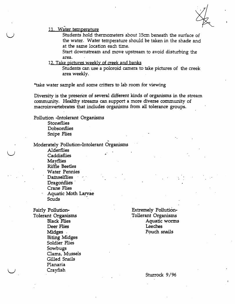
1. Collecting and observing macroinvertebrates (macro=able to be seen without a microscope, invertebrate=without backbone) from a stream can provide information about the health of an ecosyste~.
2. Examples of macroinvertebrates are: ·Urunahueandlarv~formsofinsects
black fly larva stonefly nymph mayfly nymph
• snails . • clams • leeches • crayfish ·water penny
3. Benthic macroinvertebrates (macroinvertebrates that feed on the bottom) can be classified according to their food gathering techniques. For example: increased numbers of scrapers may indicate nutrient runoff, but increased numbers of collectors may indic~te qrganic enrichment. . . .
4. As aquatic organisms, macroinvertebrates are dependent upon oxygen-. rich, pollution free water. Th~ir presence or lack of presence in a particular
body of water indicates water quatlity.
Safety 1. Wash hands after monitoring 2. Be careful of slick surfaces such as ~gae covered rock. 3. Poison ivy, snakes and fire ants are common ~ong creek bank. Be careful where you stand or sit.
Procedure 1. Arrive at creek bank, establish an area to put equipment. 2. Assign 3-S students to work together in a group. 3. Distribute equipment to work groups. 4. Students survey and record information about the creek. S. Bring everyone back together. Collect equipment. Observe critters. 6. Return to lab room.
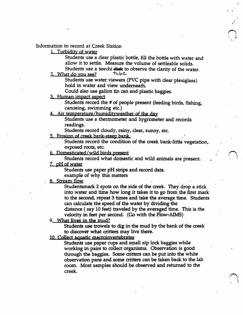
Information to record at Creek Station 1. Turbidity of water
Students use a cle~ plastic bottle, fill the bottle with water and allow it to settle. Measure the volume of settleable solids. Students use a seechi~ to observe the clarity of the water.
2. What do you see? +'-\.be,. . Students use water viewers (PVC pipe with clear plexiglass) hold in water and view underneath. Could also use gallon tin can and plastic baggies.
3. Human impact aspect StUdents record the # of people present (feeding birds, fishing, canoeing, swimming etc.)
4. Air temperature/humidityweather of the day Students use a thermometer and hygrometer and records readings. Students record Qoudy, rainy, clear, sunny, etc.
5. Erosion of creek bank-steep bank. . " Students record the condition of the creek bank-little vegetation, exposed roots, etc.
6. Domesticated /wild birds present Students record what domestic ·and wild animals are prese~t.
7. pH of water Students use paper pH strips and record data. example of why this matters
8. Stream flow' . Studentsmark 2 spots on the side of the creek. They drop g stick into water and time how long it takes it to go from the first mark to the second, repeat 3 times and take the average time. Students can calculat~ the speed of the water by dividing·the distance (say 10 feet) traveled by the averaged time. This is the velocity in feet per second. (Go with the Flow-AIMS)
9. What lives in the mud? Students use' trowels to dig in the mud by the bank of the creek to discover what critters may live there.
10. Collect aq.uatic macroinyertebrates Students use paper cups and s~all zip lock baggies while working in pairs to collect organisms. Observation is good through the baggies. Some critters can be put into the white obs~rvation pans and soine critters can be taken back to the lab room. Most samples should be observed and returned to the creek.
· .'
n f \
L=-'
u
u
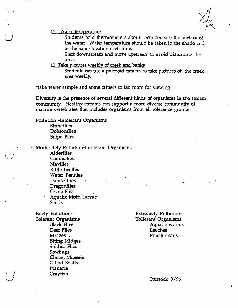
11. Water temperature Students hold thermometers about 15cm beneath the surface of the water. Water temperature should be taken in the shade and at the same location each time. Start downstream and move upstream to avoid disturbing the area.
12. Take pichlres weekly of creek and banks Students can use a poloroid camera to take pictures of the creek area weekly.
*take water sample and some critters to lab room for viewing
Diversity is the preserice of several different kinds of organisms in the stream community. Healthy streams can support a more diverse community of macroinvertebrates that includes organisms from all tolerance groups.
Pollution -Intolerant Organisms Stoneflies Dobsonflies Snipe Flie~
... Moderately Pollution-Intolerant Organisms
Alderflies Caddisflies Mayflies Riffle Beetles Water Pennies Dainselflies bragoriflies . Crane Flies . Aquatic Moth L~ae Scuds . ,
Fairly PollutionTolerant Organisms
Black Flies Deer Flies Midges" Biting Midges Soldier Flies Sowbugs Clams, Mussels Gilled Snails Planaria Crayfish
."
Extremely PollutionTollerant Organisms
Aquatic worms Leeches Pouch snails
Sturrock 9/96
."
· .. ( ) u
Glossary
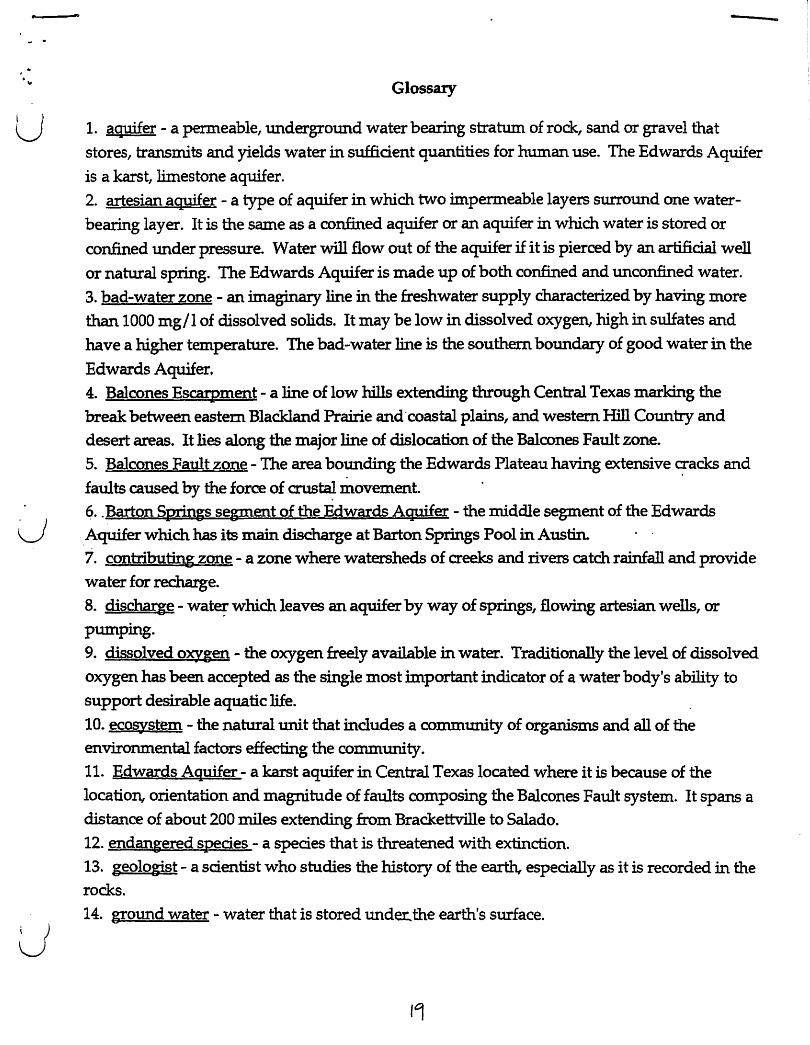
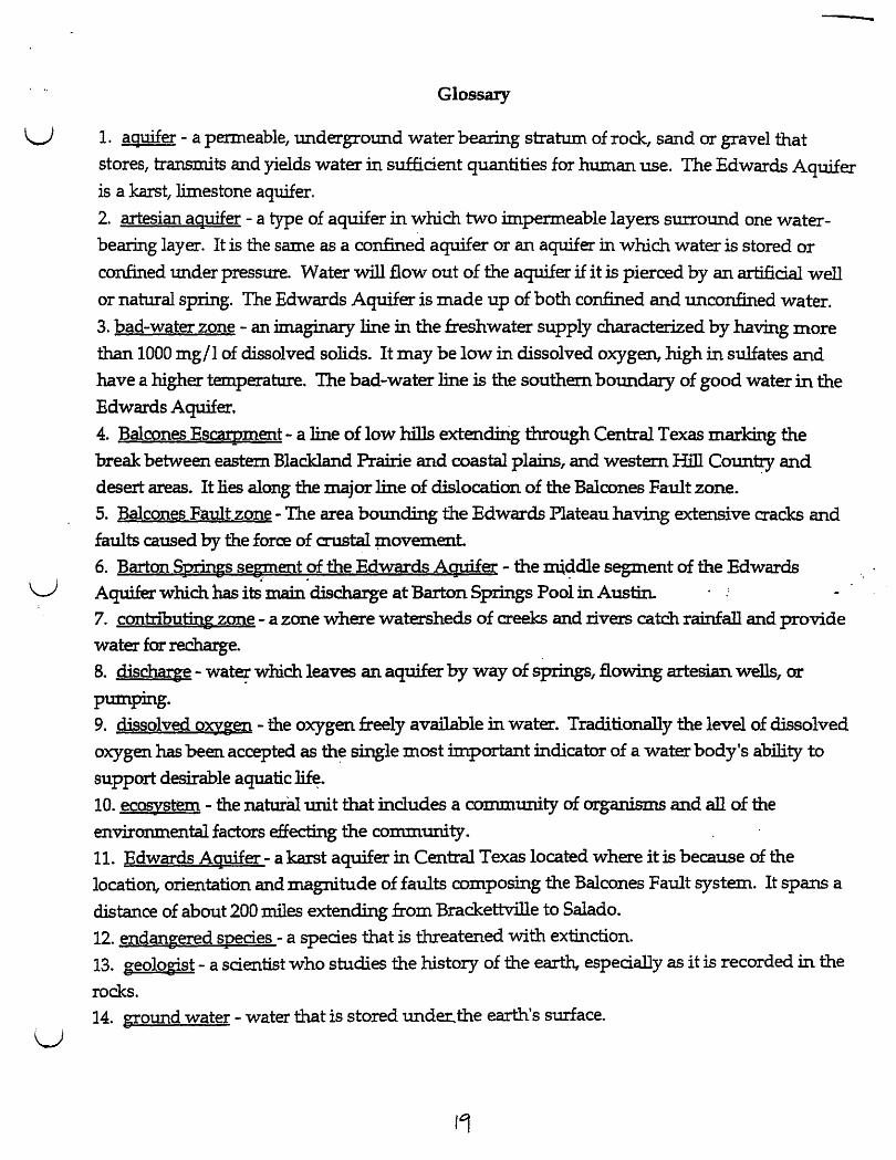
1. aquifer - a permeable, underground water bearing stratum of rock, sand or gravel that
stores, transmits and yields water in sufficient quantities for human use. The Edwards Aquifer
is a karst, limestone aquifer. 2. artesian aquifer - a type of aquifer in which two impermeable layers surround one water
bearing layer. It is the same as a confined aquifer or an aquifer in which water is stored or
confined under pressure. Water will flow out of the aquifer if it is pierced by an artificial well
or natural spring. The Edwards Aquifer is made up of both confined and unconfined water.
3. bad-water zone - an imaginary line in the freshwater supply characterized by having more
than 1000 mg/l of dissolved solids. It may be low in dissolved oxygen, high in sulfates and
have a higher temperature. The bad-water line is the southern boundary of good water in the
Edwards Aquifer. 4. Balcones Escarpment - a line of low hills extending through Central Texas marking the break between eastern Black.land Prairie and-coastal plains, and western Hill Country and
desert areas. It lies along the major line of dislocation of the Balcones Fault zone.
5. Balcones Fault zone - The area bo~ding the Edwards Plateau having extensive ~acks and
faults caused by the force of CIUS~ movement ~ .. Barton Springs segment of the Edwards Aquifer - the middle segment of the Edwards .Aquifer which has its main discharge at Barton Springs Pool in Austin. 7. contributing zone - a zone where watersheds of creeks and rivers catch rainfall and provide
water for recharge.
8. discharge - wat~ which leaves an aquifer by way of springs, flowing artesian wells, or
pumping.
9. dissolved oxygen - the oxygenfree1y available in water. Traditionally the level of dissolved
oxygen has been accepted as the single most important indicator of a water body's ability to
support desirable aquatic life.
10. ecosystem - the natural unit that includes a community of organisms and all of the environmental factors effecting the community.
11. Edwards Aquifer - a karst aquifer in Central Texas located where it is because of the
location, orientation and magnitude of faults composing the Balcones Fault system. It spans a distance of about 200 miles extending from Brackettville to Salado.
12. endangered species - a species that is threatened with extinction.
13. geologist - a scientist who studies the history of the earth, especially as it is recorded in the rocks.
14. ground water - water that is stored unde.t:..the earth's surface.
14
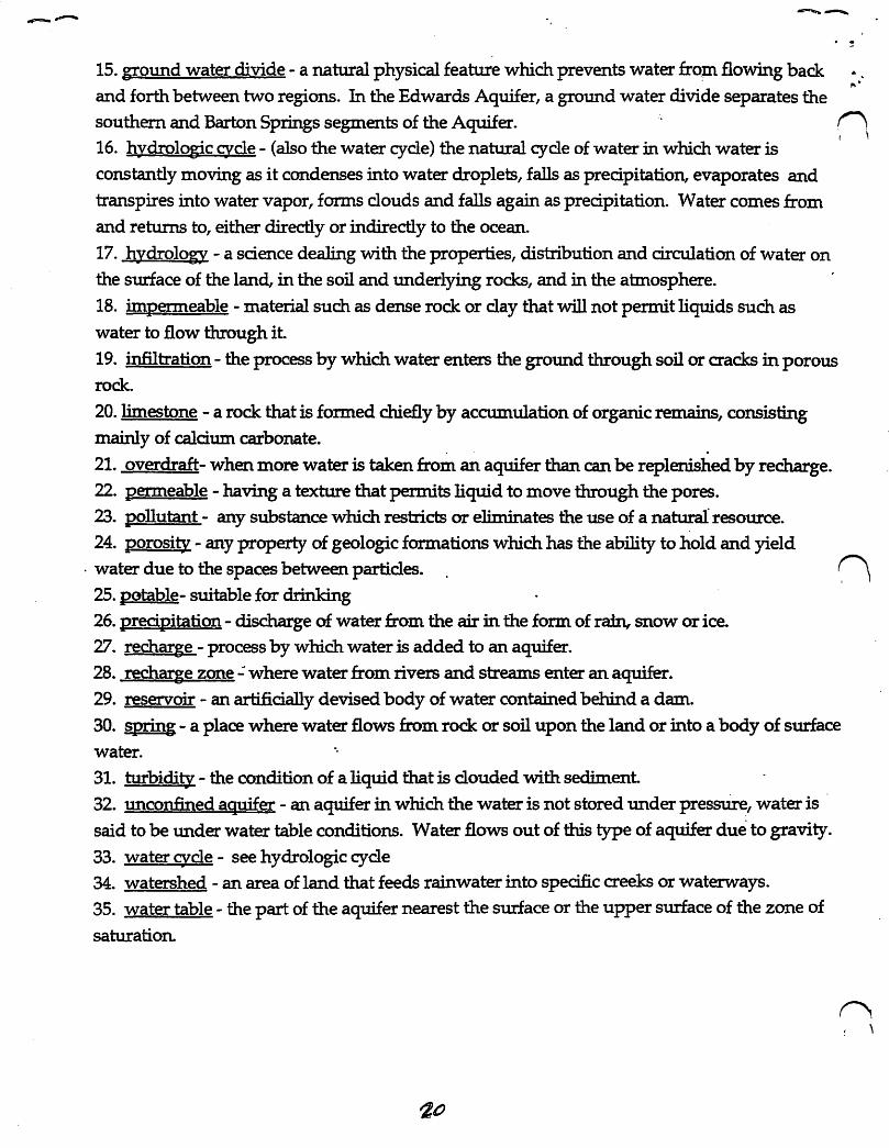
15. ground water divide - a natural physical feature which prevents water frQp1 flowing back and forth between two regions. In the Edwards Aquifer, a ground water divide separates the
",.
southern and Barton Springs segments of the Aquifer. n \
16. hydrologic c;ycle - (also the water cycle) the natural cycle of water in which water is
constantly moving as it condenses into water droplets, falls as precipitation, evaporates and
transpires into water vapor, forms clouds and falls again as precipitation. Water comes from and returns to, either directly or indirectly to the ocean.
17. hydrology - a science dealing with the properties, distribution and circulation of water on the surface of the land, in the soil and underlying rocks, and in the atmosphere.
18. impenneable - material such as dense rock or clay that will not permit liquids such as
water to flow through it
19. infiltration - the process by which water enters the ground through soil or cracks in porous rock.
20. limestone - a rock that is formed chiefly by accumulation of organic remains, consisting mainly of calcium carbonate.
. . 21. overdraft- when more water is taken from an aquifer than can be replenished by recharge. 22. permeable - having a texture that permits liquid to move through the pores. 23. pollutant - any substance which restricts or eliminates the use of a natural resource. 24. porosity - any property of geologic formations which has the ability to hold and yield
. water due to the spaces between particles.
25. potable- suitable for drinking 26. precipitation - discharge of water from the air in the form of rain, snow or ice. 27. recharge - process by which water is added to an aquifer. 28. recharge zone': where water from rivers and streams enter an aquifer.
29. reservoir - an artificially devised body of water contained behind a dam.
30. §pring - a place where water flows from rock or soil upon the land or into a body of surface water. -.
31. turbidity - the condition of a liquid that is clouded with sediment. 32. unconfined aquifer - an aquifer in which the water is not stored under pressure, water is .
said to be under water table conditions. Water flows out of this type of aquifer due to gravity.
33. water c;ycle - see hydrologic cycle 34. watershed - an area of land that feeds rainwater into specific creeks or waterways. 35. water table - the part of the aquifer nearest the surface or the upper surface of the zone of
saturation.
n \
Austin Nature and Science Center - Education Programs
Splash! into the Edwards Aquifer
09/05 Program Guide
Introduction Location: Outside, near entrance to the Exhibit
Greet teacher(s). Confirm that they are here for Splash! program. Collect money and give teacher receipt. Ask if pre .. packet activities completed. Do "headcount and record demographics. Have teacher divide students into 3 groups. Confirm that everyone understands they must have on shoes to go in the water and they will be getting their feet wet. Greet students & set stage:
"Welcome to Barton Springs Pool and the Splash! into the Edwards Aquifer Program I" [Introduce self and other program guides]
"We will be doing several activities this morning. Everyone will get to do all the activities, but in a different order." [assign groups to program guides]
Concepts: First impressions are important - know their age and where they are in the study of the topic. Brief discussion on why they are here for this program.
U See pre .. packet questions. What do they know? What will we look at?
u
What is an aquifer? Where is an aquifer located? Why is Austin's aquifer, called the Edwards Aquifer, unique? Why is Barton Springs pool important to Austin?
Schedule: GrouQ 1 GrouQ 2 Grou~ 3
9:30 Collecting* Game Exhibit
10:00 Lab (10:10) Collecting* Game
10:30 Exhibit Lab (10:40) Collecting*
11:00 Game Exhibit Lab (11 :10)
11 :30 all groups meet out front. Give teachers post"packets, posters, and game sheets. (remind them to fill out evaluations) Have students go to restrooms, use hand sanitizer, and stamp dry hands.
Clean up lab room, return supplies to closet; return critters to creek. Lock up.
*Finish collecting at end of 30 minutes and return to lab at beginning of next period. The Lab time includes the return walk from the creek.
Austin Nature and Science Center - Education Programs
Splash! Into the Edwards Aquifer - Online Resources, 09/05
http://www.aust;n360.com/recreat;on/content/recreat;on/guides/barton/barton.htm links to history, biology, geology, and pool map. Mostly accurate.
www.ci.austin.tx.us/watershed/ecamp.htm City of Austin Earth Camp teacher resources
www.cLaustin.tx.us/salamander/ lots of information about our favorite amphibian
http://www.ci.austin.tx.us/water/watertreatmentinfo.htm Austin's drinking water
www.bseacd.org/ Barton Springs/Edwards Aquifer Conservation District website
www.Edwardsaguifer.org/Pages/framesaquifer.html The Edwards Aquifer Authority (San Antonio segment) website
www.edwardsaquifer.net! Edwards Aquifer Homepage by Gregg Eckhardt. Aquifer info., Last updated??? n www.sosalliance.org non-profit advocates for saving Barton Springs
http://waterdata. usgs.gov/nwis/uv/?site no=08155500&PARAmeter cd=DD065,0 0060,00062 USGS gauging station for Barton Springs. Use to check current flow rate. Conversion factor is 1 cfs = 646,272 gpd.
http://www. epa. gov/bioindieators/htmll bioindicators and aquatic biodiversity http://www.epa.gov/win/questions.htrnl#resources watershed information .. http://www.gwpc.org/gwreportlAcrobaUtexas.pdf Texas groundwater conditions
http://www.lera.org/water/state.html Lower Colorado River Authority website. Water quality information.
www.tec.org Texas Environmental website. (undergoing re-design?) link to cd-rom.
u
u
u
Splash! into the EdwArds 14.qulfer
Creek Station
Much of the following information is borrowed from the Biomonitoring Guide of Lower Colorado River Authority.
Background Information
1. Collecting and observing macroinvertebrates' (macro=able to be seen without a microscope, invertebrate=without backbone) from a stream can provide information about the health of an ecosystem.
2. Examples of macroinvertebrates are: -immature and larval forms of insects
black fly larva stonefly nymph mayfly nymph
-snails . -clams -leeches -crayfish. ·water penny
3. Benthic macroinvertebrates (macroinverlebrates that feed on the bottom) can be classified according totheir food gathering techniques. For example: increased numbers of scrapers may indicate nutrient runoff, but increased numbers of collectors 1:1UlY indic~te 9rganic enrichment.
4. As aquatic organisms, macroinvertebrates are dependent upon oxygen-. rich, pollution free water. ~ presence or ~ack of presence in a particular body of water indicates water quatIity.
Safety 1. Wash hands after monitoring 2. Be careful of slick surfaces such as algae covered rock. 3. Poison ivy, snakes and fire ants are common along creek barik. Be careful where you stand or sit.
Procedure 1. Arrive at creek bank, establish an area to put equipment. 2. Assign 3-5 students to work together in a group. 3 .. Distribute equipment to work groups. 4. Students survey and record information about the creek. 5. Bring everyone back together. Collect equipment. Observe critters. 6. Return to lab room.
Information to record at Creek Station 1. Turbidity of water
Students use a clear plastic bottle, fill the bottle with water and allow it to settle. Measure the volume of settleable solids. Students use a 5eechi~ to observe the clarity of the water.
2. What do you see? -t"""b e... Students use water viewers (PVC pipe with clear plexiglass) hold in water and view underneath. Could also use gallon tin can and plastic baggies.
3. Human impact aspect StUdents record the # of people present (feeding birds, fishing, canoeing, swimming etc.)
4. Air temperature /humidityweather of the day Students use a thermometer and hygrometer and records readings. Students record q.oudy, rainy, ~ear, swmy, etc.
5. Erosion of creek bank-steep bank, . Students record the condition of the creek bank-little vegetation, exposed roots, etc.
6. Domesticated/wild birds present n Students' record what domestic and wild animals are present.
7. pH of wAtelj· Students use paper pH strips and record data. ~. example of why this matters
8. Stream flow' . Studentsmark 2 spots on the side of the creek. They drop it stick into water and time how long it takes it to go from the first mark to the second, repeat 3 times and take the average time. Students can ca1culat~ the speed of the water by dividing·the distance ( say 10 feet) traveled by the averaged time. This is the velocity in feet per second. (Go with the Flow-AIMS)
9. What lives in the mud? Students use'trowels to dig in the mud by the bank of the creek to discover what critters may live there.
10. Collect aquatic macroinyertebrates Students use paper cups and sp:tall zip lock baggies while working in pairs to collect organisms. Observation is good through the baggies. Some critters can be put into the white obs~rvation pans and soine critters can be taken back to the lab room. Most samples should be observed and returned to the creek.
u
u
u
11. Water temperature Students hold thermometers about 15cm beneath the surface of the water. Water temperature should be taken in the shade and at the same location each time. Start downstream and move upstream to avoid disturbing the area.
12. Take pictures weekly of creek and banks Students can use a poloroid camera to take pictures of the creek area weekly.
*take water sample and some critters to lab room for viewing
Diversity is the preserice of several different kinds of organisms in the stream community. Healthy streams can support a more diverse community of macroinvertebrates ~at includes organisms from all tolerance groups.
Poll uti on -Intolerant Organisms Stoneflies Dobsonflies Snipe Flie~
Moderately Pollution-Intolerant Organisms Alderflies Caddisflies Mayflies Riffle Beetles Water Pennies Dainselflies bragonmes'
.' .
Crane Flies . Aquatic Moth L~ae Scuds
Fairly PollutionTolerant Organisms
Black Flies Deer Flies Midges. Biting Midges Soldier Flies Sowbugs Clams, Mussels Gilled Snails Planaria Crayfish
Extremely Pollution-. Tollerant Organisms
Aquatic worms Leeches Pouch snails
Sturrock 9/96
u
u
u
Glossary
1. aQJJifer - a permeable, underground water bearing stratum of rock, sand or gravel that
stores, transmits and yields water in sufficient quantities for human use. The Edwards Aquifer
is a karst, limestone aqtrifer.
2. artesian aquifer - a type of aquifer in which two impermeable layers surround one water
bearing layer. It is the same as a confined aquifer or an aquifer In which water is stored or
confined tUlder pressure. Water will flow out of the aquifer if it is pierced by an artificial well
or natural spring. The Edwards Aquifer is made up of both confined and unconfined water.
3. bad-water zone - an imaginary line in the freshwater supply characterized by having more
than 1000 mg/l of dissolved solids. It may be low in dissolved oxygen, high in sulfat~s and
have a higher temperature. The bad-water line is the southern boundary of good water in the
Edwards Aquifer.
4. Balcones EScall'ment - a line of low hills extend±rig through Central Texas marking the
break between eastern Blackland Frame and coastal plains, and western Hill Country' and
desert areas. It lies along the major line of dislocation of the Balcones Fault zone.
S. Balcones Fault zone - The area bounding the Edwards Plateau having extensive cracks and
faults caused by the force of crustal :plovement.
6. Barton Springs segment of the Edwards AQJlifer - the nUddle segment of the Edwards .~ .. .
Aquifer which has its mam discharge at Barton Springs Pool in Austin. 7. contributing zone - a zone where watersheds of creeks and rivers catch rainfall and provide
water for recharge.
8. discharge - wate;- which leaves an aquifer by way of springs, flowing artesian wells, or
pumping. 9. dissolved oxygen - the oxygen freely available in water. Traditionally the level. of dissolved
oxygen has been accepted as th~ single most important indicator of a water body's ability to
support desirable aquatic lif~.
10. ecosystem - the natural unit that includes a community of organisms and all of the
environmental factors effecting the commuru:ty. 11. Edwards AQJJifer - a karst aquifer in Central Texas located where it is because of the
location, orientation and magnitude of faults composing the Balcones Fault system. It spans a
distance of about 200 miles extending from Brackettville to Salado.
12. endangered species - a species that is threatened with extinction.
13. geologist - a scientist who studies the history of the e~ especially as it is recorded in. the
rocks. 14. ground water - water that is stored unde:r:.the earth's surface.
14

15. ground water divide - a natural physical feature which prevents water from flowing back
and forth between two regions. In the Edwards Aquifer, a ground water divide separates the
southern and Barton Springs segments of the Aquifer. ~ 16. hydrologic cycle - (also the water cycle) the natural cycle of water m which water is
constantly moving as it condenses into water droplets, falls as precipitation, evaporates and
transprres into water vapor, forms clouds and falls again as precipitation. Water comes from
and returns to, either directly or indirectly to the ocean.
17. hydrology - a science dealing with the properties, distribution and circulation of water on
the surface of the land, in the soil and underlying rocks, and in the atmosphere.
18. impermeable - material such as dense rock or clay that will not permit liquids such as
water to flow through it.
19. infiltration - the process by which water enters the ground through soil or cracks m porous
rock.
20. limestone - a rock that is formed chiefly by accumulation of organic remains, consisting
mainly of calcium carbonate.
21. overdraft- when more water is taken from an aquifer than can be replenished by recharge. 22. permeable - having a texture that permits liquid to move through the pores.
23. pollutant - any substance which restricts or ~tes the use of a natural" resource.
.24. porositr - any property of geologic formations which has the ability to hold and yield
water due to the spaces between particles.
25. potable- suitable for drinking
26. precipitation - discharge of water from the air in the form of rain, snow or ice.
27. recharge - process by which water is added to an aquifer.
28. recharge zone': where water from rivers and streams enter an aquifer.
29. reservorr - an artificially devised body of water contained behind a dam.
30. §pring - a place where water flows from rock or soil upon the land or into a body of surface
water.
31. turbidity - the condition of a liquid that is clouded with sediment 32. unconfined aquifer - an aquifer in which the water is not stored under pres~, water is .
said to be under water table conditions. Water flows out of this type of aquifer due to gravity.
33. water cycle - see hydrologic cycle
34. watershed - an area of land that feeds rainwater into specific creeks or waterways.
35. water table - the part of the aquifer nearest the surface or the upper surface of the zone of saturation
u
u
Sp'".,,'1mo til. E...",. ~ Purpose of the Program
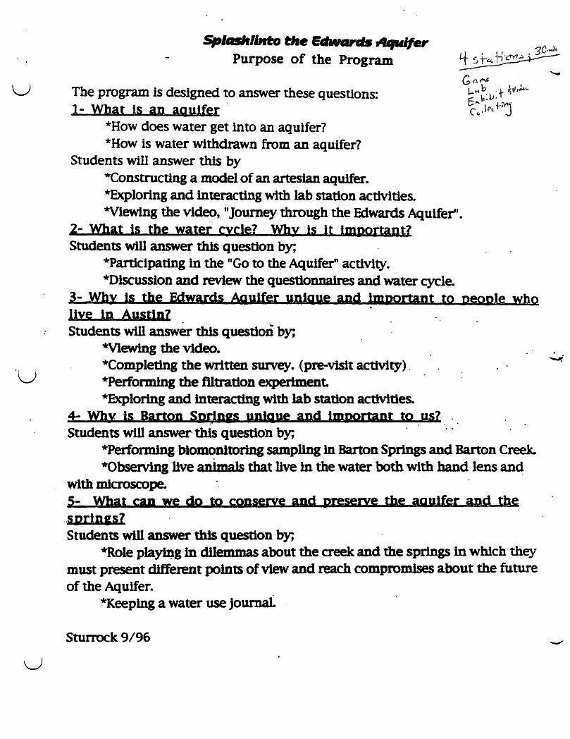
The program is designed to answer these questions: 1- What Is an ag ulfer .
*How does water get into an aquifer? *How is water withdrawn from an aquifer?
Students will answer this by *Constructlng a model of an artesian aquifer. *Exploring and interacting with lab station activities. *Vlewing the vld~,. "Journey through the Edwards Aquifer".
2- What is the water cycle? Why is it Important? Students wl1l ~er this question by;
*Participating in the "Go to th~ Aquifer" activity. *Dlscusslon and review the questlonnaires and water cycle.
3- Why Is the Edwards Aquifer unique and Important to pegple who live in Austin? . . Students will answer this question by;
"'Viewing the video. *Completing the written survey. (pre-visit activity) . *Performlng the flltratlOD experiment. *Explorlng and interacting with Jab station activities.
4- Why Is Barton SPOn.s unIQue and important to us? . . . .. Students will answer· this question by;
*Performing blomoDltoring sampllng In Barton Springs and Barton Creek. *Observing live animals that live in the water both with hand lens an~
with microscope. 5- What can we do to conserve and preserve the aquifer and the
.. sprlnss7 Students will answer this question by;
*Role pla~g in dlIemmas about the creek and the springs in which they must present different points of view and reach compromises about the future of the Aquifer.
*Keeplng a water use Journal.
Sturrock 9/96

::>p!aSh! Into the Ed\\'ards Aquifer StuJent()uestioonaDJs
Please have students complete in class before field trip ;,. ..
1~ VVhat do you think an aquifer is?
c "vater- (.L.~ (jrou.,n:J. 1 ~ ~ ~ s ~-tIA.r£:eJ ("'-0e., (Ilk. G"J~s A.,v.'\fe~ ': s '111\ •
~ u...sUA.1~ ~ ~~ 'l~ otn-'\.~e tl-V\J pt.4..r e... \lVV\e.$-b'lle, ("oc.k.'~'~ v~ \$
'De.ca.c.Lse \+ V\o:-S \oeeYl of.\ltereJ ~s ,t pe.r~l~es <'lD(J.)of) , M\ of V\oles- l,k.e oSlA)\SS
2. Where do you think Austin's drinking water comes from? ~se.. or ~ '7Jpo~e.. .
Color~o 2l6>~V\ w.e. i ~~\c:.lA ·\Sl\"e~ b'J -+he ];"J.uJd-rJs A'lA.\fer (~tov\ <£prl"5S f Cou. Sfrl~ () . L .' 'P~-tl", ~\ oer- k~ Prv..vf, f\ ..;
3. \'\Thy do you ~ that it is important for people and animals to have clean water? " S 0 ~e J.o.v.,.. + ~e..,t o\d=:-.. Ow- ~&.'es d1-e I'I'\esK~ wk. tJe. VIed LUder +0 "t.~ ~l+k:J ,f,:, c::U~sl-~ac1
-to e\\M\~-e. wa..stes a~ ~r -(~'~l~ .. 4. What do you think polluted water is?
tk wa:t~ ~ \$ ~~~\ +c, r\fe..~ ?elUtAtt~ C&l.v\ \oe \\I\troJ"'-CeJ ~eM\ceJs o..v-J.("r 'vV\.l.o~l~e.s .,V\ 4.e ~r~l ~eM\$+rj" f\
" l+(fCS)U~f>") l~ ncr a..lu.)~ vl~'l\c{e.. (~ '(f.lA ~ po\Lu..+~oV\1' -~ al~ , ) 5. What do you think would llappen if people drank polluted water?
• ~e~ u-'O v..U. tfT .t;,\ k . eXAmples. ~ e. eoll \:7.:tc.+e.rl "'-. , CA.,nc.e.,- - &'t.te.. +0 1Ou.( t&-·uf ~ -\-ex:\ V\. s
6. Where do you think water goes after it ~ used in the kitchen, the bathroom or on the n lawn and garden? 'Do lA.)e,. euer ~n tI\.,~ \t. ~\'" "? . : ..
. \+- ~e.5 ;4-0 ~e t.i8!> ~r'i>j~+eW\ -\-04 j,l)4.$~lU4-er-h-e:.d-mev.t~HHj' \AD~~fu1{'J \Al/O le~~. \t ~ d.l~o t! .~+O A.. ~ptrc.~~~tew'l.
7. What do you think would happen to Austin's water if Barton Springs dried up? It ~V.U Ie€. CL. ~'i~V\ M t.l)e .:u-e &eple:H"~&c::t1..tlfer; kp\e:H~ Dv..r~ 6UfP~"\. tfcA.' ~ (.aecJJ.~'t ~ "-'5 ~~. $eo~e. l&Lfl Q V)"I"'-j'
O\-\A.e.r ll.tI\\N\A1s ~~ toe affed-ed ~~~ ~~) '. 8. How could someone who lives in a town called Dripping Springs ~ct the water that comes out of the aquifer at Barton Springs? .
l){'\~p\",~S~r\~~ "tS tc\- ~~ heMWa:\-e.r~ '* k-to", c..reek.~ ~ ~+Aftef 4e.
~ ~4.e..,t • -\w.. tplL....+\oV\ 'Y\~ '1I\.to -/.he ~~s {1Q.o~ .dou:ln ltl\ ~\ ~r- 1,...+0
. ~ ~~(f~r ~ ~~S o~ _~~II\ ld- ~O~ cG(>Ci ~ 1/ ~ 11\ :. ~e StL+ £1
9. Draw a picture of what you ~the water cycle is on lbe back oftrus page. ~ M.Dfe. M~~ W fDl.l$l~Si +ke. ~ ~", ~ ~petl {}OM 4e. tl1W.tfer" W~ \s ().. ~t)LlS\\~M1teJ. ~c.e,e.~eA~/r.... t.eXA.-S.
Thank you for filling out this questionnaire!
1='0.- v-:.kr ~e d\~{bl..\N"l I see jif"J".d-e. tdt~lY\e.id-
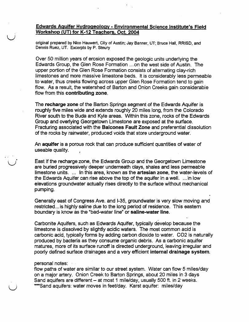
u Edwards Aquifer Hydrogeology - Environmental Science Institute's Field Workshop CUT) for K-12 Teachers, Oct. 2004
original prepared by Nico Hauwert, City of Austin; Jay Banner, UT; Bruce Hall, RRISD, and Dennis Ruez, UTe Excerpts by P. Steury
Over 50 million years of erosion exposed the geologic units underlying the Edwards Group, the Glen Rose Formation ... on the west side of Austin. The upper portion of the Glen Rose Formation consists of alternating clay-rich limestones and more massive limestone beds. It is considerably less permeable to water, thus creeks flowing across upper Glen Rose Formation tend to gain flow. As a result, the watershed of Barton and Onion Creeks gain considerable flow from this contributing zone.
The recharge zone of the Barton Springs segment of the Edwards Aquifer is roughly five miles wide and extends roughly 20 miles long, from the Colorado River south to the Buda and Kyle areas. Within this zone, rocks of the Edwards Group and overlying Georgetown Limestone are exposed at the surface. Fracturing associated with the Balcones Fault Zone and preferential dissolution of the rocks by rainwater, produced voids that store underground water.
An aquifer is a porous rock that can produce sufficient quantities of water of useable quality.
East if the recharge zone, the Edwards Group and the Georgetown Limestone are buried progressively deeper underneath clays, shales and less permeable limestone units .... In this area, known as the artesian zone, the water-levels of the Edwards Aquifer can rise above the top of the aquifer in a well. . .. in low elevations groundwater actually rises directly to the surface without mechanical pumping.
Generally east of Congress Ave. and 1-35, groundwater is very slow moving and restricted ... is highly saline pue to the long period of residence. This eastern boundary is know as the "bad-water line" or saline-water line.
Carbonite Aquifers, such as Edwar9s Aquifer, typically develop because the limestone is dissolved by slighfly acidic waters. The most common acid is carbonic acid, typically forms by adding carbon dioxide to water. C02 is naturally produced by bacteria as they consume organic debris. As a carbonic aquifer matures, more of its surface runoff is directed underground, leaving irregular and poorly defined surface drainages and a very efficient internal drainage system.
personal notes: flow paths of water are similar to our street system. Water can flow 5 miles/day on a major artery. Onion Creek to Barton Springs, about 20 miles in 3 days Sand aquifers are different - at most 1 mile/day, usually 500 ft. in 2 weeks.
U ***Sand aquifers: water moves in feet/day. Karst aquifer: miles/day
. : .. . .
'.
,---
.. , ... ~. tie· .-~ . - ..
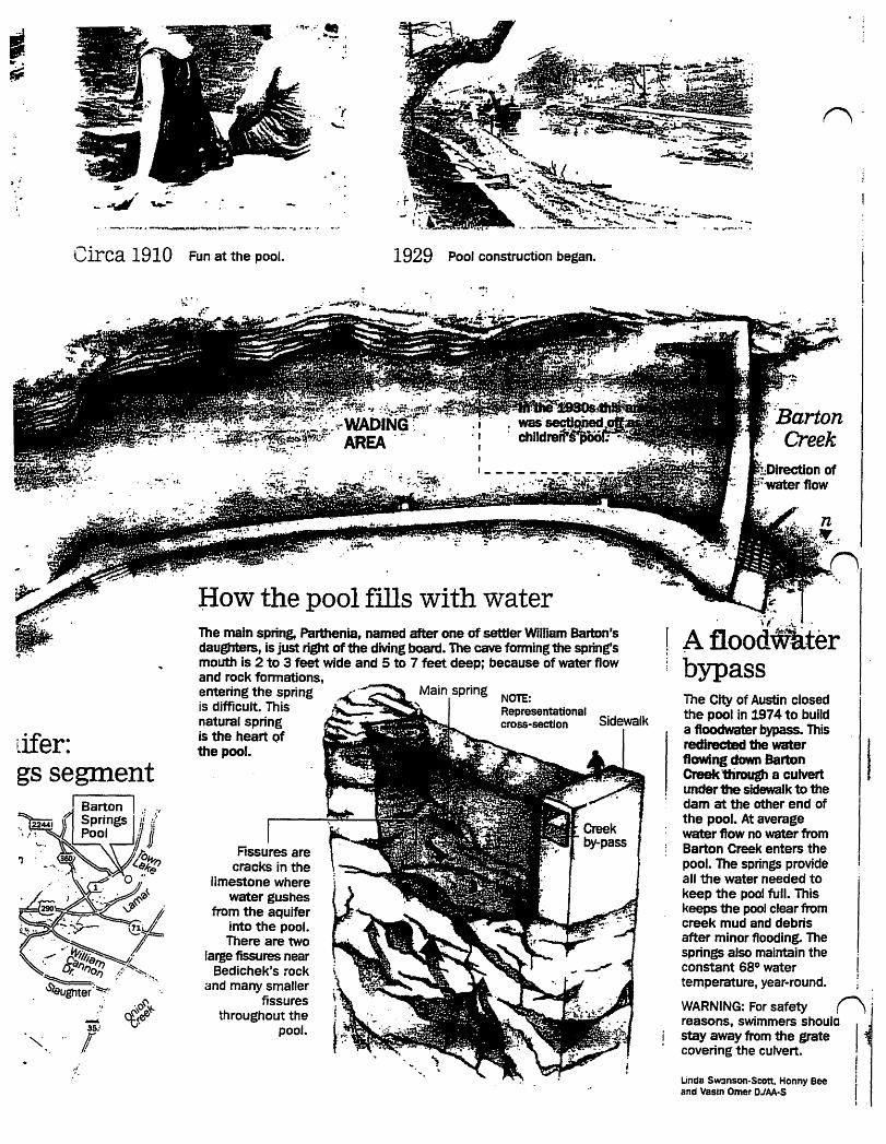
Circa 1910 Fun at the pool. 1929 Pool construction began.
" " ....,.;
35/
f
flow the pool fills with water The main spring, Parthenia, named after one of settler William Barton's daughters, is just right of the diving board. The cave forming the spring's mouth is 2 to 3 feet wide and 5 to 7 feet deep; because of water flow and rock formations, entering the spring is difficult. This natural spring is the heart Qf
the pool.
Fissures are cracks in the
limestone where water gushes
from the aquifer into the pool. There are two
large fissures near 8edichek's rock
and many smaller fissures
throughout the pool.
NOTE: Representational cross-sectJon Sidewalk
~ .
. "\'{ " .. \."
! A floodWliter I "
bypass The City of Austin closed the pool in 1974 to build a floodwater bypass. This redirected the water flowing down Barton Creek 1firough a culvert
I under the sidewalk to the . dam at the other end of
the pool. At average water flow no water from Barton Creek enters the pool. The springs provide all the water needed to keep the pool full. This keeps the pool clear from creek mud and debris after minor flooding. The springs also maintain the constant 68° water temperature, year-round.
WARNING: For safety n j reasons, swimmers shoulo 11 stay away from the grate covering the culvert. " "
I Linda SW3nson-Scott. Honny Bee I and Vasin Omer DJAA-S I
I
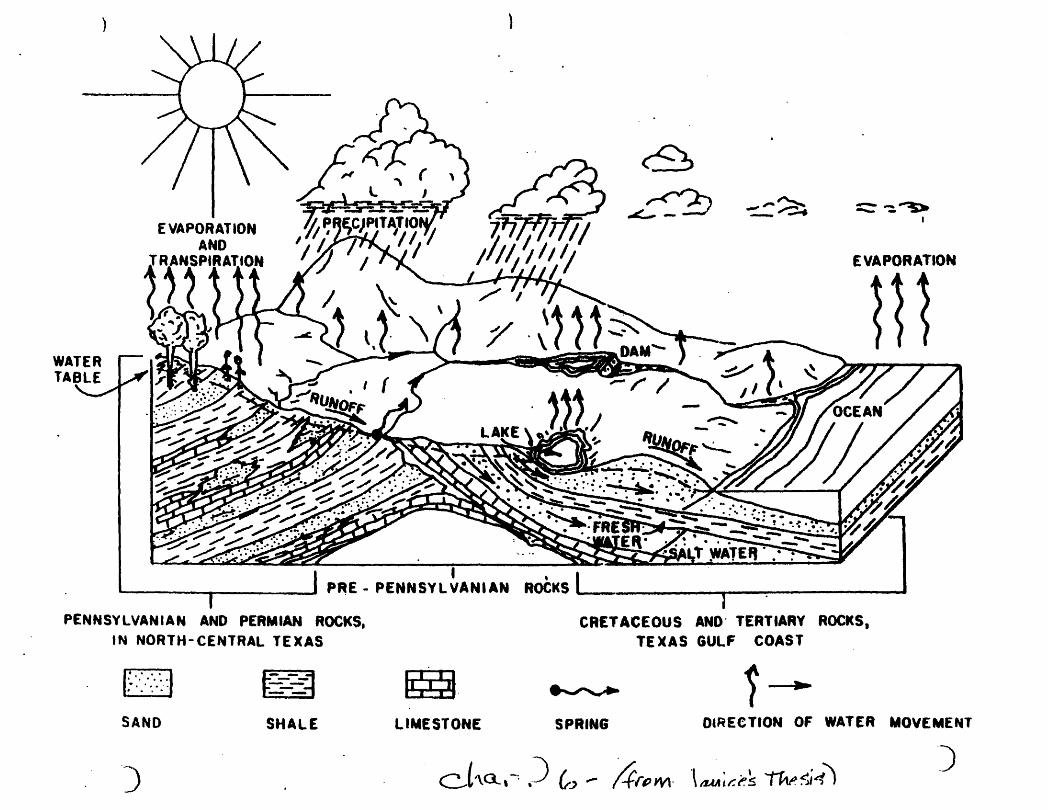
I ~ ______ ~ ______ ~, P~E-PENNSYLVANIAN
PENNSYLVANIAN AND PERMIAN ROCKS. IN NORTH-CENTRAL TEXAS
Do., . ',. ... .
•• .... e'· ...
SAND
~ ~ SHALE
00 LIMESTONE
~ r<'?;
-"'-- - - -,,..~ -~ :::::- -:. ~
EVAPORATION
II ~
CRETACEOUS AND' TERTIARY ROCKS, TEXAS GULF COAST
~ i ... SPRING DIRECTION OF WATER MOVEMENT
) cJ'\Q,-, ,) fr., ~ .4rpWl \aM;cA '"f1iv.~~1 -)

Splash Exhibit Tour Script revised 09/05
Film. (note: an American Eel is shown in video. Females migrate upstream, from Caribbean.)
In the corridor, just past the cave crawl-thru: Now that you have seen how the aquifer was formed, we will now take a closer look at what the Barton Spring segment of the aquifer means to us.
The Barton Springs segment is composed of three layers of rock. Del Rio Shale, Edwards Limestone, and Glen Rose Limestone. Which of these three layers is more permeable to water? (explain permeable?) Correct, the Edward's Limestone has a very high porosity while the other two layers are essentially impermeable. Throughout most of the Balcones Escarpment, the Edward's Limestone is sandwiched between the impermeable layers, resulting in a confined or artesian aquifer. This means that our segment of the aquifer is under high pressure and water can come to the surface without a pump wherever there is an opening - Barton Springs! That is one reason Barton Springs is so special. It is one of the few natural occurrences where water from the aquifer comes to the surface. (approximately 50 million gallons per day) (film states 33 million) (which is correct???)
There are other reasons why this area is important. I'm sure you have all seen the road signs that read uN.ow entering the Edward's Aquifer R~charge.ZoneEnvironmentally Sensitive Area." What does that mean? I. •
The Recharge Zone is where the Edward's limestone is exposed at the ground surface, and is not confined by the Glen Rose or Del Rio shale layers anymore. Why then does the exposure of the Edward's limestone make it an environmentally sensitive area? Edward's limestone is a karst limestone. It has lots of holes and crevices and it is easy for water to move thru these holes. We say it is highly permeable. In a sand, clay, or gravel type of aquifer, the water moves much more slowly and it gets filtered as it moves along. In a karst aquifer, like we have here in Central Texas, the water doesn't get filtered. Any industrial waste, runoff from streets, parking lots, car w~shes, lawn chemicals, what have you, goes directly into the aquifer, through the limestone and no filtering occurs. As they say in the computer industry, "Garbage in, garbage out. II
By the Diorama (model of watershed with buttons) Now that we've seen where the water is stored underground and how it come out at Barton Springs, let's look at how the water actually gets into the aquifer.
(Allow everyone to orient themselves and practice pushing the buttons. Explain that you will touch their shoulder when it is their tum to push their button.) Barton Springs is just one of three segments of the Edwards Aquifer - it's the smallest one too. The northern segment extends from Town Lake to Salado. The southern one is under San Antonio and extends up to around Kyle. Interestingly, water does not seem to flow between the three segments.
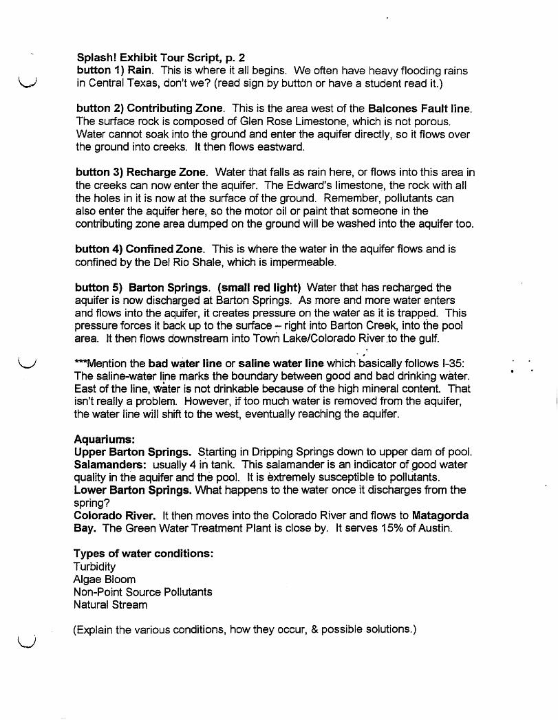
u Splash! Exhibit Tour Script, p. 2 button 1) Rain. This is where it aI/ begins. We often have heavy flooding rains in Central Texas, don't we? (read sign by button or have a student read it.)
button 2) Contributing Zone. This is the area west of the Balcones Fault line. The surface rock is composed of Glen Rose Limestone, which is not porous. Water cannot soak into the ground and enter the aquifer directly, so it flows over the ground into creeks. It then flows eastward.
button 3) Recharge Zone. Water that falls as rain here, or flows into this area in the creeks can now enter the aquifer. The Edward's limeston~, the rock with all the holes in it is now at the surface of the ground. Remember, pollutants can also enter the aquifer here, so the motor oil or paint that someone in the contributing zone area dumped on the ground will be washed into the aquifer too.
button 4) Confined Zone. This is where the water in the aquifer flows and is confined by the Del Rio Shale, which is impermeable.
button 5) Barton Springs. (small red light) Water that has recharged the aquifer is now discharged at Barton Springs. As more and more water enters and flows into the aquifer, it creates pressure on the water as it is trapped. This pressure forces it back up to the surface - right into Barton Creek, into the pool area. It then flows downstream into Town Lake/Colorado River :to the gulf .
• #
U ***Mention the bad w~ter line or saline water line which basically follows 1-35:
u
The saline-water line marks the boundary between good and bad drinking water. East of the line, water is not drinkable because of the high mineral content. That isn't really a problem. However, if too much water is removed from the aquifer, the water line will shift to the west, eventually reaching the aquifer.
Aquariums: Upper Barton Springs. Starting in Dripping Springs down to upper dam of pool. Salamanders: usually 4 in tank. This salamander is an indicator of good water quality in the aquifer and the pool. It is extremely susceptible to pollutants. Lower Barton Springs. What happens to the water once it discharges from the spring? Colorado River. It then moves into the Colorado River and flows to Matagorda Bay. The Green Water Treatment Plant is close by. It serves 15% of Austin.
Types of water conditions: Turbidity Algae Bloom Non-Point Source Pollutants Natural Stream
(Explain the various conditions, how they occur, & possible solutions.)
The Salamanders Austin's "Canary in a coal mine" 09/05
"Miners took canaries into the mines with them in order to detect toxic, odorless gases. If a canary passed out or died, it was time to get out of the mine."
by John Dromgroole. contrlbuter to Barton Springs Eternal
"Take care of the salamanders and we take care of the water. II Kent Butler
The Barton Springs Salamander (Eurycea sosorum) is our "canary". It's presence is an indicator of good water quality. The very thin skin and external gills makes the salamander extremely susceptible to pollutants.
Listed as an Endangered Species in 1997. lithe primary threats to this species are degradation to the quality and quantity of water that feeds Barton Springs due to urban expansion over the Barton Springs watershed. Also of concern is disturbance to the salamanders surface habitat in the pools where it occurs. This action implements Federal protection provided by the Act for the Barton Springs salamander." (USFWS,1997)
All of the known surface habitats of the BS salamander are found within Zilker Park ... which include Barton Springs, Eliza Springs, Sunken Gardens Springs, and Upper Barton Springs.
Source: http://www.cLaustin.tx..us/salamander/ (paraphrased); r-'l Totally aquatic, it does' not metamorphose into -a terrestrial adult. (While most salamanders lose their gins, the Barton Springs salamander does not.) It is lungless and relies on it's conspicuous red gills located behind the head for efficient gas exchange. It is found only at the four spring locations in Zilker Park. Surveys indicate they are found primarily near the spring outlets. It is not known to what extend their range extends into the aquifer. (It has only been found at the four springs in Zilker Park) No eggs have been discovered in their native habitat.
Since Eliza Springs has been cleaned out, the counts have rocketed from dozens to hundreds. Biologists (usually Laura Dries) from the city make regular counts, but accurate population estimates at all four spring locations are not possible.
One favorite food is the scuds. Crawfish may be a predator. However, the primary threats to the BS Salamander are the degradation of the quality of water that feeds Barton Springs due to urbanization over the BS watershed.
Adults grow to a length of 2.5 inches (6.35 cm).
Second species of salamander was recently discovered. (at Sunken Gardens?) It is a blind salamander, Eurycea waterlooensis and not yet listed as endangered. More rare and limited in habitat range than the Barton Springs salamander.

~
\J ..
v
Austin Nature and Science Center
Splash! Into the Edwards Aquifer
Teacher Training Manual
Prepared by Teresa McDonold September 15, 1999
©ANSC 1998
. ~ -v\[} 4 'YZ.l5 OJ f-il~\AJ1
. 'rra C),))7 j\_q/).Q~ )tJ (t/}C) ) S ,) )/Y\Z
Q ., S~~.\.IJJS ,?Zl)? r }I'of V10)1"l)J)j-VS' /~ -l) 00l ~ . --- ---~-~ 7(J~ S~O') fiY'?.N S"\f\I)O'N "?)'I\'7'J1Jc! ( 5~ .L')r./S ~W)<A - \j,\-~ ,
O\YJ"Vj~ 07/1 \GQ /\(1\ 'frd~"'Ou. (~~~!~1J\lY) O-\,{I) ~ "YIn >~\}'1 )W~ (~') Q\IV ~ )~).Y)cY\f.1' <1\-'V\1 ;,,-\J ",-,\, t 0 i't\ -? ~ <t
. . 5 M t?' A J CL.\['Vl) - ~ s 0 ~ \Il1f \ lh)Jt1' f' 0 S '\1\Y\ ~ 0'1 \-\ - r~
~u1 ",,:(VJ-Z\ - 4S1 .. ~_::;;;'"
I v/}"'J.\f 1-/' r) \I '''5 . '\\6\ \,\ S'{) ~ \0 N . ') fl1\ -;\ Sf!
__ I -'. -C;h~7}a-F7C\§J~------~-
r. -,
U
I I
I
a I
"
>F)Q"\~ -4_'~'JY\W oS ~\"lJ - dhW]dS 'vJn\!\: . f ')'\7) :nCf) '? )I \') S) 0 j~ j Q \ Q)'O -e..
0--
~.roJ 1(7 ~ 0) YJ J) . Il~owft.~~ .
..• 4 rfV\.01 ~\)1:~ -0 \Jli(l __ fr ''YSa .~VJ([
--")-,(,OV)'S Q .~() \?O ~ ... 'PrOOrvG r \
S t) a '\ ~ \i) ,I '\ )td / YLf\ ~ -'\I}\'no ? S \ \ a ..ll )o?-\,'YJ f\/\
~t1t ?0AY)v(7r~-'Sif\O'\I\ jo .,0\ YJ )y)V\ --')r..>'l)(Y\YD3
.'-, "
C5\Nl.~ S)J.JI]01f-3 PI n 0 5\\0) I -o~\jl Z '\"\0~ ( 'J}'\70
rtWJ1G\II WJ'Yl~ ~V\0'i) - -d)07,\ \JV?-\ lc)
~ :~ ~~
. S OIav\. v~ )0/ )LY 7'-U4S7-WlJj ~ 'l'rfi SO)C'V) tv_Lf'?.?rD (' P:?J'f 5,?)yW~/J/,) ~,?s
/""YJe?S XJ- ~O~1:? s~h \.VY\i 001
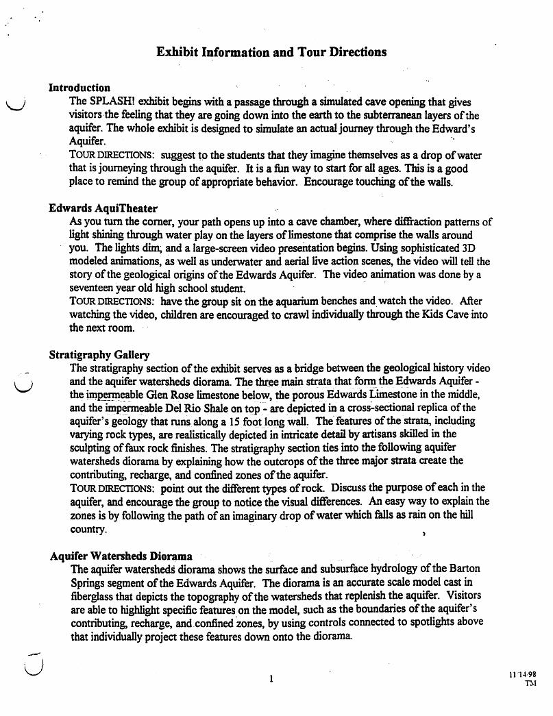
u
Exhibit Information and Tour Directions
Introduction The SPLASH! exhibit begins with a passage through a simulated cave opening that gives visitors·the feelirig that they are going down into the earth to the subterranean layers of the aquifer. The whole exhibit is designed to simulate an actual journey through the Edward's Aquifer. " TOUR DIRECTIONS: suggest tp the students that they imagine themselves as a drop of water that is journeying through the aquifer. It is a fun way to start for all ~ges. This is a good place to remind the group of appropriate behavior. Encourage touching of the walls.
Edwards AquiTheater As you tum the comer, your path opens up into a cave chamber, where diffiaction patterns of light shining through water play on the layers of limestone that comprise the walls around you. The lights ~ and a large-screen video presentation begins. Using sophisticated 3D modeled animations, as well as underwater and aerial live action scenes, the video will tell the story of the geological origins of the Edwards Aquifer. The video animation was done by a seventeen year old high school student. . . TOUR DIRECTIONS: have the group sit on the aquarium benches and. watch the video. After watching the video, children are encouraged to crawl individually through the Kids Cave into the next room.
Stratigraphy Gallery The stratigraphy section of the exhibit serves as a bridge between the geological history video and the aquifer watersheds diorama. The tb(e~.main strata that fonn the Edwards Aquifer -thejm~!!l!~~ble Glen Rose limestone below, the porous Edwards Limestone in the middle, and the imP~rm~able Del Rio Shale on t()p-:"_ are depicted in a cross~sectional replica of the aquifer's geology that runs. along a 15. fOQt JOllg wall~ The features of the strata, including varying rock types, are realistically depicted in intricate detail by artisans skilled in the sculpting of faux rock finishes. The stratigraphy section ties into the following aquifer watersheds diorama by explaining how the outcrops of the three major strata create the contributing, recharge, and confined zones of the aquifer. TOUR DIRECTIONS: point out the different types of rock. Discuss the purpose of each in the aquifer, and encourage the group to notice the visual differences. An easy way to explain the zones is by following the path of an imaginary drop of water which falls as rain on the hill country.
Aquifer Watenheds Dior~ma The aquifer watersheds diorama shows the surface and subsurface hydrology of the Barton Springs segment of the Edwards Aquifer. The diorama is an accurate scale model cast in fiberglass that depicts the topography of the watersheds that replenish the aquifer. Visitors are able to highlight specific features on the model, such as the boundaries of the aquifer's contributing, recharge, and .confined 'zones, by using controls connected to spotlights above that individually project these features down onto the diorama.
1 11'14·98 T~I
A cross section running roughly north-south down through the middle of the aquifer's recharge zone divides the diorama into western and eastern portions.' Under the visitor's control, the western po~on rises approximate1ysix' inches to reveal the aquifer below. The visitor can then see how surface water enters the aquifer through sinkholes in creekbeds and then travels north underground until it reaches the surface at Barton Springs in Zilker Park. TOUR DIRECTIONS: discuss how- the water travels into the aquifer, what each section means and relate the locations to the group by using places with which they are familiar.. A good technique at this station is to assign one child to a button, and start by pointing to the rain on the hill country button, and continue by following the drop qfwaterthrough the different zones. This method helps to prevent the 'push all the buttons at once' problem, and helps the children understand what they see.
Aquatic Habitats Habitats from the Hill Country to Matagorda Bay The Barton Creek watershed is brought to life with a series of aquariums that trace the path of the hydrologic cycle from central Texas to the Gulf of Mexico. In the first aquarium, rain
. falling on the upper reaches of Barton Creek flows over riftles and through pools filled with darters, and then down into a sink hole as it reaches the recharge zone of the Edwards Aquifer.
Species: Gr~n-throatedDarter Etheostoma lepidum The next aquarium depicts a spring outlet similar to those in Barton Springs pool that together discharge an average of 30-50 millions gallons of fresh water per day from the aquifer into lower Barton Creek. In cooperation with the U.S. Fish and Wildlife Service and with the support of the Texas Parks and Wtldlife Department, this tank features a refuge population of endangered Barton Springs Salamanders.
Species: BartonSprlngs _~~~a.nder Euryceq sosorum Water from the spring outlet tank appears to flow into the next aquarium, which exhibits the fauna and flora of lower Barton Creek. Because it receives cool, constant temperature water from the springs year-round, this section of Barton Creek is home to a unique aquatic ecosystem.
Species: Guadalupe Bass Micropterus dolomieui Central Stoneroller Campostoma anomalum Mosquito Fish Gambusia affinis Mexican Tetra Astyanax mexicanus
In the following aquarium, lower Barton Creek appears to empty into Austin's Town Lake, which is a dammed reservoir on the Colorado River that is home to native species of catfish, bass, and other aquatic species. .
Species: Green Sunfish Lepomis cyanellus Guadalupe Bass Micropterus dolomieui Texas Cichlid Cichlasoma cyanoguttatum Bluegill Lepomis macrochirus
A mural along the wall depicts the flow of the Colorado River from . Austin towards the Gulf of Mexico. The exhibit culminates with a diorama of Matagorda Bay that illustrates how moisture from the Gulf evaporates into the atmosphere and theQ. returns to central· Texas as rain.
2
. .
n 11/14/98
TM
u
TOUR DIRECTIONS: dis~ss the change in_habitat from upper Barton Creek to the Colorado river. This isa good area tQ J~ ~bQg~J~Qw~babitats and ther~foreflora &' tau.na~ vary even along the same creele, and rel3tethedifferent habitats to the different sections. of the aquifer i.e.oontributin~ -rech-arge-and confining. This is also a good place to talk about the water cycle starting with rain in the hill country to evaporation and condensation over the Gulf of Mexico.
" . Non-point Source Pollution T .. bes This exhibit· focuses on the effects of non-point source pollution on tJte quality of our region's water supply. Four large, clear tubes tilled with water convey working definitions of some of the terms we use to describe water quality. The differences between clean, toxic, eutrophic and turbid waters are emphasized by the presence of ponution-related artifacts within the tubes.
u
u
BACKGROUND INFORMATION: N:on-PQ~t sourc~. pollution istb.e term us~to ·describe many small, individual instances of water pollution th~t caiinot b~eas~y~ced to a single point. Some examples of nonpoint source pollution are I} toxicity from urban development-oil and grease from parking lots, leaky petroleum storage-tanks, pesticides, cleaning solvents, and other toxic chemicals can contaminate our creeks and kill natural aquatic oJ;'ganisms .. 2) ieutn~~hicat!on -the process by which a water body becomes "rich in inorganic . compounds~ These compounds, typically. n.itrogen and phosphorous, stimulate excessive algae gro\Vth. Because plants such as algae breathe oxygen at night, a massive algae bloom in a creek or river can consume much of the dissolved oxygen out of a body of :water. When this b~ppens, fish and Q~be! [email protected]!~anin.tal~ Who also need oxygen ~y die Qifin high.numbers. A1so~--riVers-and creeks that become choked with algae create a haven of stagnant water for microorganisms, mosquitoes, and .other pests. 3) turbiditythe ~ount of particulate ~~~er .SJ1spended 4t ~he water. Fast flowing runoff from rooftops and paved surfaces can cause erosion and build-ups of silt in our creek beds. Disturbances of the soil from construction can allow silt to wash into the creeks, making them muddy and inhospitable to natural aquatic organisms.
TOUR DIRECTIONS: before discussing anything, encourage the group to tell you what they see in the tub~s. This is also a good place to gather the group together, and go over the rules for the rest of the exhibit. Since it is hands-on and interactive encourage touching and thinking. Tty not to explain everything first. Let the group experiment, and then highlight different activities and make suggestions.
Re8l-time Aquifer Water Quality' Data' and Weather Station Actual real-time readi~gs of the quality of the aquifer water flowing into Barton Springs Poo~ as wen as local weather conditions, are displayed on monitors overhead as you enter the Water Science section of the SPLASH! exhibit. An electronic probe fitted with special sensors transmits data from the bottom of a well beside Barton Springs up to the Barton Springs Bathhouse. The data displayed in the exhibit includes turbidity, dissolved oxygen, pH, specific conductance, and temperature. Weather data, such as rainfall, air temperature,
3 11114/98
Thl
humidity, and wind speed, is taken directly from sensors atop a pole in Barton Springs Pool, and then displayed in the exhibit." " TOUR DIRECTIONS: Since these monitors are small and in a busy area, it may be better to go over them with a few stUdents at a time. Discussion about the meaning of the different readings should be encouraged. This stop is a good place to emphasize the importance of weather to water quality. "
Water Quality Hands On Exhibits Spectrophotometer Water Tester "
This exhibit demonstrates how scientists use a spectrophotometer to measure the levels of dissolved contaminants in our water. A map of the greater Austin area displays 24 lighted button switches that represent sampling sites along many of our local creeks. By pushing any one of the buttons on the map, the visitor can initiate a simulated testing sequence of the water quality at that particular site. A large clear tube, representing a spectrophotometer cuvette, will fill with water and then shine brightly as it is illuminated by dazzling light of different wavelengths. Overhead, a computer monitor will describe various aspects of spectrophotometric" testing, and then display actual results for that sampling site from tests conducted "at City of Austin and LCRA water quality laboratories. In this way, the visitor will see that we can use light to test the water for things that we can't see with our eyes alone. By sampling the water quality at different sites around Austin we can observe how the quality of the water in our creeks varies in urbanized and rural areas. BACKGROUND INFORMATION
A spectrophotometer measures the number of molecules of a specific chemical in a sample of water by illuminating the water with light that is tuned to a single wavelength that is efficiently absorbed by those molecules. By subtracting the amount of light that is absorbed from the total amount of light that the sample is illuminated "with, an estimation is made of the number of molecules of that particular chemical in the water sample. Water is a lot more than just H20; many different chemicals occur naturally in water, while others are present due to human activity. Nitrogen (N) and phosphorous (P) are important nutrients for the water plants and algae that fonn the base of aquatic food webs. Although they are naturally found at low levels in most natural waters, excessive levels ofN and P can cause algae 'blooms and encourage eutrophication. Minerals such as calcium, magnesium and sodium, and metals such as copper, iron and zinc dissolve into the water from limestone and other rocks in the aquifer and in creek beds, as well as from the soil as rain filters through it. If elevated levels of heavy metals such as lead, arsenic, and cadmium are found in surface or ground water, it is usually from a manmade source, such as runoff from roadways and urban areas.
TOUR DIRECTIONS: "encourage students to sample creeks from different land u)se areas and compare the results.
Aquifer Mini-Submarine" Activity Station Visitors are invited to navigate a virtual submarine through the underground channels of an aquifer to track down the source of bacterial contamination in the watershed. A vast network of water-tilled caves typical of the karst aquifer environment are simulated in a multimedia kiosk using high resolution computer animations. The kiosk has a joystick controller for
4
, .
(~
11/14198 Thf
u
u
--,.
steering through the animated subterranean passages, and has other controls to convey the feeling of operating an underwater laboratory ship .. When the opera~or comes to branching waterways, they are prompted to take a water sample to trace the bacteria W4en the MiniSub operator passes under a sinkhole, he or she will be able to extend a virtual periscope to scan the surface for pollution-causing events that may be occurring above ground BACKGROUND INFORMATION . ..
Bacteria are essential for the healthy functioning of our aquatic ecosystems. They decompose the organic matter from dead animals and plants so that minerals and nutrients can be taken up. by other organisms m a new Cycle of life. They also break down toxic waste products, such as ammonia, from animals intQ simpler molecules, such as nitrates, that can be safely consumed by other organisms. Recent research has shown that bacteria play an important role in many geological processes. They may excrete acids that accelerate the breaking up and dissolution of rock fonnations. Some bacteria are known to concentrate minerals to create an enonnous variety of compounds such as carbonates, sulfides, phosphates, oxides, and sUUcates. . One of the microbes that are carried out of our bodies and into the sewage systems is fecal colifonn. If there are elevated levels of fecal coliform bacteria in our creeks, it might indicate that a nearby sewer pipe may be leaking or a septic tank may be malfunctioning. Fecal coliform also comes from other mammals. besides humans. High concentrations of livestock in feedlots, or parks that are littered with excessive amounts of dog feces can generate high levels of fecal colifonn as well. Fecal coliform bacteria are harmless to humans~ but their presence can indicate the likely presence of other bacteria, viruses, fungi, or parasites that can cause human diseases. Water is tested for fecal coliform bacteria by taking a known amount of water and filtering it through a thin paper pad. The pad is placed into a petri dish with growth media that provides food for the bacteria, and then the petri dish is placed into an incubator at 44 degrees Celsius for 24 hours. During this time, any fecal coliform bacteria present will take advantage of these ideal growth conditions and multiply in a process called binary fission. After 24 hours, individual bacteria on the filter paper will have multiplied into colonies that can be seen as spots on the paper with very little magnification. If an average of more than 200 colonies from a sample of 100 ml of water is counted, the water is considered to be unsafe for swimming.
TOUR DIRECTIONS: this area is self explanatory. Encourage the students to be gentle with the joy stick, and complete the activity before moving on. .
Bug Inspector Biomonitoring Activity Station The use of small invertebrates as indicators of creeI.c water quality is explored in the Biomonitoring Activity Station. A display case with a magnifying glass on a rolling track houses several small animal specimens such as mayflies, dragonflies, or wonns. The students are invited ·to examine the specimens closely and identify them by using the key on the touch screen computer. Included in the int~ractive presentation is information on what kind of water quality is indicated by each particular species.
s
· BACKGROUND INFORMATION In an urbanized watershed, there may be a wi~e Variety of contaminants that can disrupt . natural aquatic ecosystems. Testing for each contaminant by using a spectrophotometer or other laboratory ·equipment can be time-consuming and expensive, especially when many sites within a watershed rc;quire regular monitoring. To address this ·concern, the ('\ City of ~stin has been .reflning a system called Rapid Biological Assessment, or simply, biomonitoring, to detect where contaminants might be present in in aquatic ecosystem. This method, instead of relying mainly on chemical analyses, eXamines the numbers and kinds of organisms that are present at different points aJong a creelc. C~ types o.f water animals, known as macroinvertebrates, as well as algae such as diatoms, are collected regularly at designated sampling sites. Because some aquatic species are very sensitive to pollution, while others are more tolerant, noticeable declines or increases in specific aquatic species can alert a biologist to a possible source of nearby pollution. The biologist can then take a water sample from the site to the laboratory for more rigorous analysis to identify ~ctly what specific contaminalits may be causing the shift in aquatic species composition.
TOUR DIRECTIONS: . direct the students to follow the directions on the screen, and look closely at the animals.
Barton Springs Interactive CD-ROM Kiosk This station features a multimedia kiosk that provides visitors a chance to sample the new "Barton Springs Interactive" CD-ROM. The CD-ROM provides an in-depth look at Barton Springs from a culturaI perspective. Historical photos and anecdotes, along with interviews with longtime swimmers and other patrons of the Springs will show how this 1000 foot-long, spring-fed pool in the heart of the city has become one of our community's most treasured natural resources. The CD-ROM was produced by Texas Environmental Center, and can be i~ purchased at the Splash Store Gift Shop outside the exhibit. TOUR DIRECTIONS: encourage students to sit and explore the cd-rom. Ask them to be careful with the computer. .
Aquifer Periscope This station features a large copper periscope that has a viewer for the student to look into and watch underwater footage. TOUR DIRECTIONS: this is an individual activity. Encourage taking turns. Please don't allow the students .to hang on the periscope.
Find Your School in the Watershed The City of Austin lies at the confluence of many creeks that drain into the Colorado River, which runs through the center of town. By using the Find Your School in the Watershed activity station, visitors to the SPLASH I exhibit are able to i4entify which watershed they inhabit. A large 3 I-inch monitor displays a map of the greater Austin area divided by school districts. Clicking on any of the districts will then bring up a map of that area with the school locations marked. There is also a list of schools in that area along the side of the screen. When the student clicks on their schoo~ another map appears that shows the boundaries of the watershed that the school lies within.
6 11114198 TM
u
u
u
TotJ'R DIRECTIONS: It is interesting to find your watershed then go to the spectrophotometer and find out what the water is like where you live. '
Pollution Prevention Pond In the Austin area, water quality ponds are widely used for the mitigation of non-point source pollution. Although they are becoming a common sight in our community's parking lots, many area residents may not understand what they are and how they work. This station features a model parking lot with toy cars and a water quality pond" shown in cross section. Small beads running out fro~ under th~ cars will ron down"the "lot and into the pond to demonstrate how the pond can trap particulate matter. In order to etpphasize the importance of regularly cleaning out water quality ponds to keep them properly functioning, the student is invited to operate a hand-controlled front-end loader to scoop out the beads from the pond, and then drop them into the bed of a large dump truck. A hidden recirculation system takes the beads from the truck and then puts them out again underneath the cars. The beads then roll back down into the pond.
, BACKGROUND INFORMATION Structural controls, generally, are of two types - ponds which hold runofffor short periods of time in order to control peak flow rates (flood detention ponds) and those which hold water for longer periods for water quality treatment (water quality ponds). Often a site will have both types of ponds. A flood detention pond usually is a large. basin into which stormwater from a parking lot, roadway, rooftops, and other areas>:of impervious cover flows when it rains. The storm water collects in the pond and then is released slowly into the' stonnwater drainage system and eventually flows into the local stream. Because the water released into the creek has been detained until the heaviest rainfall has passed, peak flows are decreased and damage to stream banks from erosion is reduced. A water quality pond is designed to collect and hold run-off for longer periods of time in order to remove pollutants. There are many different methods in use such as sand filtration or newer "wet pond" designs which utilizes a permanent pool of water and aquatic plants as the treatment mechanism.
TOUR DIRECTIONS: remind students to take turns.
Erosive Veiocity Sediment Transport Activity Station The Sediment Transport Activity Station demonstrates the relationship between the speed of water flowing through a creek and the corresponding level of erosion and sediment transport within a watershed. A circular raceway filled with" water serves as a creek model. The student initiates the action by turning a lever on the front of the model that actiyates a pump in the creek bed to accelerate the water around the raceway. Small plastic pellets resting in the bottom of the creek, channel represent the soil bottom of the creek bed. As the water moves faster, more and'more of the pellets are picked up and carried along with the flowing
. water, thus demonstrating erosion and sediment transport BACKGROUND INFORMATION
As w~ter flows through a natural watershed, it may carry with it suspended particles of dirt that have been eroded from the topsoil in the watershed, bits of leaves or twigs from nearby trees and plants, organic debris from aquatic organisms, and dust that has fallen
7 11/14/98
from the atmosphere. If the water slows down and becomes still, these tiny suspended particles will settle to the creek bed. When the :water speeds up again, it mAy begin to exhibit turbulent flow, which will pick up the sediment and keep ,it suspended' and churning in the water as it flows downstream. ' -Hill Country creeks are usually composed of a series of shallow rocky areas, or riftles, where the water flows swiftly and turbulently, and pools where the water slows down and flows more calmly. Water flowing in the shallow riftles tends to scour the bottom and pick up sediment which ,keeps riftle areas clean and clear. The turbulent flow in riftles keeps their water highly charged With oxygen. Accordingly, riftles provide· an ideal habitat for many aquatic organisms. , When the water reaches a pool, it slows down and drops its sediment load to create thick areas of silt deposits. The calmer water may allow the luxurious growth of water plants and algae. Accordingly, riffles and pools create very different types of habitats, and the types of aquatic organisms found in each ~e often noticeably different. Creeks that _ receive much' of their ~off from urban areas often lose their alternating pool and riftle structure. Woody debris and larger ro'cks that partially dam up the creek to create pools are washed away by the increase in storm flows that rapidly run off of impervious cover. The faster-flowing water erodes the banks of the creek and widens it, especially on the outside edges of curves. In urban areas, this erosion may cause creekside property oWners to lose significant portions of their land, and may threaten the stability of their buildings. A common solution to this problem is to install concrete channels in sections of the creek that are badly eroding. Unfortunately, although this may solve the erosion problem in that immediate area, the water velocity may actually accelerate in the newly channeled sections, and the problem of erosion will be simply exported to unchanneled areas downstream. If the problem of excessive water velocity is handled the same way again and again when erosion becomes a problem, most of the creek may wind up being channeled. Ultimately, in place of a natural creek with a diverse community of animals and plants, there may be simply a long, concrete drainage ditch that is incapable of supporting a native aquatic ecosystem.
Stormwater Run-ofT Simulator The Stormwater Simulator Station demonstrates how high levels of impervious cover can change the way rainfall run-off flows through a watershed. Two watershed models are presented side-by-side: the one on the left is a natural landscape, while the one on the right is an urbanized- area with many parking lots, streets, rooftops, etc. Above each watershed, equal amounts of "rain" will be suspended in cloud-like reselVoirs. Under the student's command, the rain falls first on the natural watershed, and then on the highly developed one. A flow meter in each of the 'creek channels graphs the pattern of discharge as the run-off flows through each watershed. The flow meters then send their readings to a cbmputer equipped with National Instruments Lab VIEW software. Overhead, the computer's monitor presents a multimedia display of overlapping graphs of the speed and duration of the flow of water through the two wate~sheds. The multimedia presentation then helps the student interpret the graph to understand why higher levels of impervious cover can alter a creek's natural appearance and its capacity to support native wildlife.
8 11/14/98 TM
BACKGROUND INFORMATION: . When we build our .homes, work places, and p~ay areas within ~ a watershed, we inevitably affect the way water flows through that w.atershed. 111, ~turaI ar~as, rain water nonnally seeps into the ground then slowly flows through soil to the nearest creek. The flow of water that is held in the soil and slowly released is called base flow. Storm flow occurs when· the soil is saturated and' can no longer absorb, additional·rainfall. During stann flows, the water flows swiftly on top of the soil towards the creek instead of through the soil. When we cover the natural landscape with roads; buildings, parking lots, etc., the rain runs r.apidly off' of these impervious Surfaces and into stann drains that often empty directly into· to a nearby creek, rather than soaking into the soil. Accordingly, increases in impervious cover can increase the frequency and intensity of storm flows in a watershed. Also, because the rain cannot reach the soil beneath the impervious cover to seep slowly towards.the creek,.the amount of base flow is reduced. Research by civil engineers, biologists and hydrologists has shown that when 10-15% of a watershed is covered by impervious surfaces, the natural functioning of its aquatic ecosystem may . begin to degrade. The faster flowing water that comes off of the developed areas with higher impervious cover levels can increase the rate of erosion and flooding in the creek downstream, and disrupt the habitats of animals and plants that live there. In addition, runoff from streets and parking lots may contain levels of petroleum hydrocarbons (oil and grease) and other toxic materials that are harmful to aquatic ~e. In many of the urban watersheds studied so far, high impervious cover levels have leet- to losses of the natural pool and riftle structure of the creeks, to a significant widening. and deepening of each creek's channel, and to a dramatic decline in the diversity of native aquatic wildlife. Community planners try to balance the man-made and natural . environments to arrive at a level of imperviou~ cover that the watershed can handle without compromising the quality of the water, without creating erosion and flooding problems downstream.
TOUR DIRECTIONS: direct the students to press both buttons at the same time to get a flow rate comparison.
Aquifer Library Step inside and use the Internet computers to do more exploring, and to obtain more informatiQn. about the aquifer. TOUR DIRECTIONS: encourage use of the facility, but monitor the students.
Exhibit ends at bubble doon
ConsenratioD and Preservation of the Barton ·Springs Edwards Aquifer pollution discussion infonruition For thousands of years, the springs of the Edwards Aquifer have provided the peoples of Texas with clean fresh water. The introduction of the "Aeromoter" windmill to Texas in 19th century, as well as later improvements in water well technology and irrigation, facilitated the growth of farms, ranches and towns up and down the Edwards Aquifer, from Belton to Uvalde.
9 1l.'14·98 TIl
. . In our portion of the Edwards Aquifer - the Barton Springs segment - 41,000 people live in areas that have no o~her source but the aquifer for drinking ~ater. The ~ area's growth in the last decade has begun to strain the region's water supplies. Since 1985, the number of peOple living over the contributing, recharge, and artesian zones of the Barton Springs 'Edwards Aquif~r has more than doubled. Using ground water supplies to meet demands from future groWth will require (\ careful planning ~d cooperation from all of the members of the cOmmunity who have a stake in the continued health of the aquifer and Barton Springs. . Barton Springs is a tremendous natural and cultural resource for the people of central Texas. It is one of Austin's main tourist attractions, second only to the state. capitol. Each year,. over-300,OOO people pass through its gates to enjoy the pool' s coo~ fresh water, where they can swim alongside
. fish and explore.a native aquatic ecosystem. But if too many wells are drilled into the aquifer and more and more water is pumped out for human use, the flow· at Barton Springs could be reduced to the point where swimming there is no longer feasible. Also, expanding areas of urban development in the contnouting and recharge zon~ of the Barton Springs Edwards Aquifer may threaten groundwater . supplies ~d Barton Springs Pool with non-point source poUution. . Although the overall health of the aquifer is currendy excenent, scientists have alre8.dy begun to detect traces and, on rare occasions, unsafe lt~vels of man-made chemicals or heavy metals in water wens. if continued urban development in the contributing and recharge zones causes significant deClines in water quality in the creeks that replenish the aquifer, non-point source pollution might one day make Barton Springs unsafe for swimmers, and cause the ~oss of the aquifer as a source of clean, safe drinking water.
10 11114198 1M

u
u
u
Austin Nature and Science Center SpIGsltI into tlte Edwards 14quifer
1. Purpose of the Program 2. Program Outline 3. Training manual 4. Glossary S. Manual attachment
Training Manual Table of Contents
"Go to the Aquifer" Station Creek Station Lab Station Informal science education
6: Bibliography
Other enclosures • Hill Country Oasis • Barton Springs/Edwards Aquifer Conservation District Brochure • Barton Springs Pool Brochure
. I
I •
SpICISII/lftto tile Etlwtut:ls ""Idler Purpose of the Program n
The program is designed to answer these questions: 1- What is an a9 uifer
*How does water get into an aquifer? *How is water withdrawn from an aquifer?
Students will answer this by *Constructing a model of an artesian aquifer. *Exploring and interacting with lab station activities. *Yiewing the video" "Journey through the Edwards Aquifer". ,
2- What is the water cycle? Why is it important? Students will ~swer this question by;
*Partlcipating in the "Go to the Aquifer" activity. *Discussion and review the questionnaires and water cycle. .
3- Why is the Edwards AQUifer unique and important to people who live in Austin? Students will answer this question by;
*Yiewing the video. n *Completing the written survey. (pre-visit activity) *Perfonning the ffitration experiment. *Explormg and interacting with lab station activities.
4- Why is Barton ~prln8s unique and imp~rtant to us? Students will answer this question by;
*Perfonning biomonitoring sampling in Barton Springs and Barton Creek. *ObseIVing live animals that live in the water both.with hand lens and
with microscope. S- What can we do to conserve and preserve the aguifer and the springs? Students will answer this question by;
*Role playing in dilemmas about the creek and the springs in which they must present different points of view and reach compromises about the future of the Aquifer.
*Keeplng a water use journal.
Sturrock 9/96
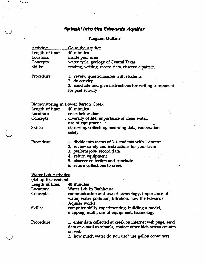
u
u
u
Activity: Length of time: Location: Concepts: Skills:
Procedure:
Splll5llllllto tile EdwClr • .4quifer
Program Outline
Go to the Aquifer 40 minutes inside pool area water cycle, geology of Central Texas reading" writing, record data, observe a pattern
1. reveiw questionnaires with students 2. do activity 3. conclude and give instructions for writing component for post activity
Biomonitorinl in Lower Barton Creek Length of time: 40 minutes Location: creek below dam Concepts: , diversity of life, importance of clean water,
use of equipment . _ Skills: observing, collecting, recording data, cooperation
safety
Procedure: 1. divide into teams of 3-4 students with 1 docent 2. review safety and instructions for your team 3. perform jobs, recor4 ~ata 4. return equipment 5. observe collection and conclude 6. return collections to creek
Water Lab Activities (Set up like centers) Length of time: 40 minutes Location: Water Lab in Bathhouse Concepts: communication and use of technology, importance of
water, water pollution, filtration, how the Edwards Aquifer works
Skills: computer skills, experimenting, building a model, mapping, math, use of equipment, technology
Procedure: 1. enter data collected at creek on internet web page, send data or e-mail to schools, contact other kids across country on web 2. how much water do you use? use gallon containers
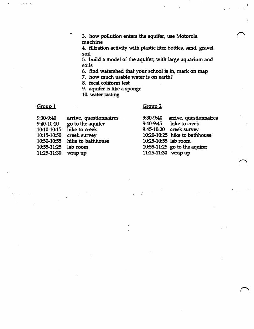
Group 1
9:30-9:40 9:40-10:10 10:10-10:15 10:15-10:50 10:50-10:55 10:55-11:25 11:25-11:30
3. how pollution enters the aquifer, use Motorola (') machine 4. filtration activity with plastic liter bottles, sand, gravel, soil 5. build a model of the aquifer, with large aquarium and soils 6. find watershed that your school is in, mark on map 7. how much usable water is on earth? 8. fecal coliform test 9. aquifer is like a sponge 10. water tasting
arrive, questionnaires go to the aquifer hike to aeek creek survey hike to bathhouse lab room wrapup
Group 2
9:30-9:40 arrive, questionnaires 9:40-9:45 hike to creek 9:45-10:20 creek survey 10:20-10:25 hike to bathhouse 10:25-10:55 lab room 10:55-11:25 go to the aquifer 11:25-11:30 wrap up
u
u
u
Austin Nature and Science Center
Splash! into the Edwards Aquifer
Instructor Training Manual
Fall 1996
written by Janice Sturrock
"But besides their contribution to an o~tstanding swimming pool and to the
public water system, the springs also have major ecological and geological
values. They provide a window into a part of the earth's interior and afford
clues to the operation of geologic, hydrologic and biologic systems along
the Balcones Fault Zone and Escarpment". (Woodruff & Slade, 1984).·
What is an'aquifer? An aquifer IS a permeable underground water bearing stratum of rock, sand or gravel
that stores, transmits and yields water in sufficient quantities for human use.
The Edwards Aquifer of South Central Texas is a reservoir of water held in a cavernous,
porous, honeycombed limestone formatio~ located underground. The a.quifer was formed
about 100 million years ago when much of Central Texas was covered by a shallow sea.
Remains of small sea dwelling creatures such as shells and corals, were deposited on the floor
of this sea and formed layers of what is now the Edwards Limestone formation. Over. millions
of years, movements within the earth such as earthquakes and faulting, shifted the rock,
exposing sections .of the limestone south and west of what is now Austin.
About 17,OOO;000.years elga, shifting in the earth's crust caused major faulting anq
uplifting which resulted in the Balcones Escarpment of Central Texas. (Water, W~ter C~nseryation and the Edwards Aquifer, 1994).
(See map 1, the Balcones Escarpment)
Rock fractures along fault lines allowed rainwater to infiltrate the limestone,.and dissolve rock,
creating the honeycombed appearance and high porosity of the Edwards Aquifer. (Hill
Country Foundation, 1995). Today's aquifer is a lattice work of tiny holes, cracks, caverns and
caves that serve as a holding tank for water. Over millions of years, water dissolved parts of .
the limestone above the ground and carved many channels and caverns below ground. In
Central Texas, the network of caverns and channels below ground is what is called the
Edwards Aquifer.
1
i . .i. ....
Water enters an aquifer as precipitation that falls in the recharge zone. It eventually
makes its way into the underground water table. Water leaves the aquifer through natural n springs and artificial wells drilled into the aquifer.
What is B~rton Springs? Barton Springs is an oasis of clear, cold wat~r located in Zilker Park in Austin, Texas. It
is the fourth largest spring in the state, releasing millions of gallons of fresh water from the
Edwards Aquifer each day. For many people who live in Austin, Barton Springs Pool provides an unique, spring fed swimming hole that offers relief from the long, hot, dry summers of Central Texas. For others, Barton Creek, whose waters feed the springs, offers a quiet, green, natural area just minutes from the hustle and bustle of downtown Austin.
Barton Springs is like a big faucet for the Barton Springs segment of the Edwards
Aquifer. About 950/0 of water that enters the Barton Springs segment is discharges at Barton Springs. Water that enters the Barton Springs segment, comes from the watersheds of six creeks. The creeks are Bear, Little Bear, Slaughter, Williamson, Onion and Barton, with the
greatest amount of rec~ge coming from Barton.and Onion Creeks. Basically, whatever enters the aquifer as recharge in these watersheds, is discharged at Barton Springs. Water
flows out of the pool, into Barton Cr~k and enters Town Lake. Austin's drinking w~ter
comes froin Town Lake. n
(See map 2, the Barton Springs segment of the Edwards Aquifer)
These creeks win~ through nfr~, sub.urb~ .~d ·.urban areas. Barton Creek provid~s ab0':1t 280/0 of the recharge to the aquifer, and water entering Barton Creek reaches the springs quickly. Water from Onion Creek provides about 340/0 of the recharge that flows into this
seginent of the aquifer. Because water flows through the Edwards Aquifer so quickly,
disturbances that occur upstream can be measured at the springs within a matter of hours.
(Slade, et al., 1986). The pool created by the springs provides the city with its "jewel in the crown" of unique
natural features that help define Austin's quality of life. The pool is a major recreational attraction for Austin as well as a supplier for part of the city's municipal water supply. Water
from the springs enters Town Lake about one half mile upstream from the Green Water
Treatment Plant. This plant provides ~d and east Austin with drinking water, accounting for
about 280/0 of the total water for the city. The Barton Springs segment of the Edwards Aquifer is the middle segment of the larger
karst, limeston~ aquifer that underlies a region known as the Balcones Escarpment of Central n 2

u
u
u
Texas. "The Balcones Escarpment lies along the major line of dislocation of the Balcones fault
zone ... " (Woodruff & Abbott, 1986). "The Aquifer is located where it is because of the location,
orientation and magnitude of faults composing the Balcones Fault system." (Woodruff &
Slade, 1984).
(See map 3, the Balcones Fault Zone)
The Balcones Escarpment is a line of low hills that extends through Central Texas. It is a surface expression of a deep-seated crustal discontinuity in which dramatic changes in
landscape occur. The Escarpment is also a major weather-maker. Although the limestone hills
are only a few hundred feet high, they offer the first topographic break inland from the Gulf of
Mexico. The Balcones Escarpment is the locus of the largest flood producing storms in the
contiguous United States. (Woodruff & Slade, 1984).
The Balcones Escarpment and fault zone provide physical divisions of east from west.
Within the big picture of North America, the Escarpment marks a break between the Great
Plains to the west and the Coastal·Plains to the east. In Texas, this division is marked by
relatively flat, clay soilS and more abundant rainfall of the Blackland Prairie anefcoastal
regions to the east, and the hilly, thin limestone soils of the Hill Country and desert regions to
the west. (Woodruff & Abbott, 1986). In the 1800s, lifestyles were determined by the fault line
with cotton farming and urban areas developing to the east and ranching developing to the
west. (Woociruff, Marsh & ~ilding, 1993). .
The abundance of water provided by Barton Sprin~ has determined flora and fauna of
. the area as well. as the development of human settlements for the last 11,000 years. The springs
~ere·one of the main attractions for development of the city of Austin in the 1830s. The great
diversity of plants and animals in the Austin area is dictated by the fault zone.
Species of plants and animals found in Central Texas along the Balcones fault zone are
numerous because the fault creates an nedg~1t in which two ecological zones meet. Great
diversity of both plant and animal life can exist. Species from both ecological zones are found
within short distances of one another. For example, to the east there is the fox squirrel and to
the west, its counterpart, the rock squirrel. The blue jay is the eastern counterpart to the scrub
jay of the Hill Country. Some species are limited by the fault zone such as those dependent
upon plants whose distribution is determined by the fault. Today, there is much competition fpr water in the Edwards Aquifer. Children who live
in and around Austin will determine the future of the aquifer and the springs with their choice
of lifestyles and their votes for elected officials. How much they know, understand and care
3
# _~ J.".
about the water will influence their decisions concerning the Barton Springs segment of the Edwards Aquifer.- n History of development in the Barton Creek watershed
In February of 1979, the Austin City Council and Planning Commission adopted the Austin Tomorrow Comprehensive Plan. The plan was developed over several years with extensive input from citizens. It became a blueprint for growth of the city with consideration
for the threat that uncontrolled growth could present to Austin's unique environment. The
plan outlined a preferred growth corridor to extend north and south along Interstate Highway. 35 and did not support construction over the sensitive Barton Springs Zone. (Ramanathan, 1994).
Despite careful planning for the future of the Barton Spr~gs Zone, there has been exterisive construction of homes, roads and commercial ventures in the Barton Springs
contributing watershed zones. Between 1980 and 1994, the total amount of public funds that
had been spent to subsidize growth in the Barton Springs Zone was over $474,000,000.00. These monies have gone to pay for municipal utility districts, major road construction such as the Southwest Parkway and Mopac Highway South, new schools and suburban housing developments. (Ram~than, 1994).
Ordinances that have been established to protect watersheds and creeks in Austin are n being challenged. Building continues to occur directly over the environmentally sensitive aquifer. Construction increases the possibility and probability that runoff and recharge waters entering the aquifer within the Barton Springs watershed will become increa~ingly polluted,
transporting pollutants into th~ aquifer. About 95°fc, of w~tever ente~s the aquifer· with
recharge waters in the Barton Sprmgs segment is discharged at Barton Springs. (Hill Country Foundation, 1995). The Edwards Aquifer is more vulnerable to pollution than some other . aquifers because thin layers of limestone that separate ground water from surface water, offer
little or no filtration of pollutants.
The City of Austin and Travis County continue to struggle to maintain a balance
between economic growth and environmental sustainability. Prevention of water pollution is
desired because the cost in dollars to clean up environmental damage is enormous. (Hill
Country Forum, Summer 1994).
Intricately intertwined in the future of water quality in the Barton Springs segment are
components of the ecosystem of the area .. One example is the Barton Springs salamander,
Eurycea sosorum. As of the fall of 1996, federal legislation does not list the salamander as an endangered species, despite research reports that indicate that it truly is endangered. (Cole,
Hutchison, Roesner, Schram, &; Yelderman, 1995). n 4
u
u
u
The listing would have implications concerning development within the Barton Creek watershed and coUld render as illegal any development causing destruction of habitat or
danger to the species. In March of 1995, United States Secretary of the Interior, Bruce Babbit said,
"The Barton Springs salamander, like other .species at risk, is the proverbial' canary in the coal mine' for Texas residents
who depend upon or care about this priceless natural resource. The salamander functions here as an indicator of the overall health of the aquifer spring system and the damage that can be done to this irreplaceable natural resource." (Mittelstadt, 1995).
Local media has pitted those concerned about future water quality against those who want to build over the aquifer. Citizens of Austin and outlying areas continue to be divided. and polarized concerning no growth versus economic growth versus managed growth.
"Rapid urban development is <?Ccwring in the Austin area.
. Much of this development is occwring in the watersheds which contribute recharge to the Edwards Aquifer. Such development can degrade the quality of runoff from these
areas, and thus degrade the quality of water in the aquifer.
Clearly, th~re is.a needJ?r ad~qua~e ~ormation.to plan and assess the impacts of development on the aquifer".
(Woodruff &: Slade, 1984).
(See map 4, the Barton Springs recharge and contributing zones).
Dangers facing the Barton Creek watershed and ultimately, the discharge of waters at Barton Springs, are depletion and pollution "Ground water originating from Barton Creek
remains in the aquifer for only a short period before discharging at Barton Springs." (Dorsey,
Slade &: Stewart, 1986). Increased turbidity, indicating high concentrations of suspended clay
and silt in the water, reduce visibility. "Changes in turbidity of Barton Springs water after a
storm show how rapidly recharge wate.r, with its relatively high turbidity, moves through the aquifer to discharge at Barton Springs." (Dorsey, et al., 1986).
5
1. The Importance of Water
. Water is tliat wonderfully unique compound that is composed of two atoms of n hydrogen and one atom of oxygen. It has special qualities that allow it to exist in three
. different states, to change from one of these states into another and back again. It can perk up
a thirsty plant and quench a dry throat. Every living thing needs water. The problem is that
there is only so much water. It cycles through its various forms, condensing from gaseous water vapor to a drop of water and freezing into ice. There is a finite amount of water on
earth, sometimes called the water planet, because 750/0 of it is composed of water. You can change the state of it, you can change the quality of it, you can drink it, or swim in it, or ski on . it, but you cannot get any more of it. The water that you drink tomorrow, may be the same water that a dinosaur drank 70,000,000 years ago.
Even though 75% of the earth is made of water, only a small portion of that water is available for use. About 97% of all of the water on earth is salt water .. Water frozen in'ice caps
and glaciers comprise about 2 %. That leaves only about 1% of water that is usable, fresh water.
To have a concrete example of the percentage of usable water, imagine a 10 gallon container filled with water. If you remove all of the salt water, all of the frozen water and all of the polluted water, there would be 9 drops of usable fresh water available. (Barton
Springs/Edwards Aquifer Conservation District, 1995). n Because every living thing needs water, water and the quality of it is very important. It
has always been very important, ever since life on earth began; but there has never been so
much competition for it as there is now. Human populations have multiplied, pollution of
water has increased and people are beginning to wony if there wUI be enQugh clean w~ter for the future.
In Central Texas, near the ci~es of San Anto~o and Austin, the fresh water supply comes from the Edwards Aquifer. Whether or not there will continue to be enough water is of
increasing concern among residents of Central Texas. -The southern segment o~ the Edwards
Aquifer, which underlies the city of San Antonio, is located just south and west of Austin. This
segment of the aquifer supports the fresh water needs of 1.5 million people, provides for
agricultural crop irrigation in six counties and distinguishes San Antonio as the largest city in the world that depends upon a single source for its drinking water.
Although San Antonio and Austin are both situated atop the Edwards Aquifer, within
70 miles of each other, the two cities lie in different segments. San Antonio lies in the southern
Edwards and Austin lies in the middle portion, known as the Barton Springs segment of the Aquifer. The northern segment extends north of Austin to Salado, Texas. Because of natural . physical features in the aquifer, water does not flow back and forth from one segment to n
6
u
u
u
# ; •• :.
another. Overdraft of one segment does not directly effect water levels in the other two
segments. In Austin, . drinking water comes from surface water in Town Lake. On average,
Barton Springs contributes approximately 32,000,000 gallons, or about 100/0 to the daily flow of Town Lake.
(See map 5, the three 'segments of the Edwards Aquifer)
Although water does not flow between the southern and Barton Springs segments of
the ~dwards Aquifer, Austin is indirectly effected by fluctuations in water levels in the'
southern segment. Water district officials in San Antonio are looking to the Highland Lakes,
which include Town Lake, located in the middle of Austin~ for potential drinking water sources for the future for San Antonio. '
"The water concerns of each are~ of the state are intricately tied to those of the rest of the state". (Webb, 1954).
(Se~ map 3, the Balcones Fault Zone) ~'.:~ .
An living things need water. The availability of water on earth determines the
abundance and distribution of life. There is a finite amount of water on earth. Water has
unique charact~ristics that distinguish it from other compounds.
1) all living things need water
2) there is a finite amount of water on earth
, '3) water is the only substan~e that Occurs naturally in three' states.of solid, liquid and
gas. Water is constantly moving from one state to another and back again.
4) water is the universal solvent, it can dissolve many materials.
Carbon dioxide gas, present in soil and air combines with water to form carbonic acid
which has the ability to dissolve limestone. Throughout millions of years in Central Texas, this
carbonic acid has dissolved the relatively soft limestone rock and created many caverns and
caves throughout the Edwards Aquifer region.
All living things need water. The human body is composed of about 65°k water. This
means that if you weigh 100 lbs., 65 pounds of you is water. Water is essential for bodily
functions of living creatures. It transports food, oxygen and waste products. It aids in
regulating body temperature. It is essential for many of the chemical reactions in the human
body. Without water, humans could only exist for a few days. (Water, Water Conservation
and the Edwards Aquifer, 1994).
7 .
Plants also need water. In fact, plants need far more water than an animal of
comparable weight. The transport processes of plants that govern intake of carbon dioxide fQ~ photosynthesis are dependent upon water.
2. The Water Cycle
Water is composed of two atoms of hydrogen and one atom of oxygen, H2O. The water
cycle is a series of repeating events in which water circulates naturally through surface water,
ground water and the atmosphere. In the water cycle, there is no beginning and no end.
Water evaporates (changes from a liquid to a gas), and transpires (a process in which plants
lose water to the atmosphere) to form clouds, condenses (changes from a gas to a liquid), and
falls as precipitation (discharge of water from the air ) in the form of rain, snow or sleet.
(See chart 6, the ~ater cycle).
The water cycle is much like a terrarium in which moisture is absorbed from the soil
into plants that transpire water as vapor into the air where it condenses on the top of the
terrarium and falls back onto the plants' as dew or rain. - .
Events of the water cycle that taKe place in any part of the world are affected by events
in all other parts of the world. Rainfall in Central Texas could come from the Gulf of Mexico en it could come from distant seas. (Water, Water Conservation and the Edwards.Aquifer, 1994).
3. Ground Water'and Surface Water
A. Grouild water ,is wate~ that is s~ored under the earth's surface. Gr~undwater is the
largest single source of fresh water available to and commonly used by people. Ground .Water
supplies about 61% of the total water used in Texas. (Ground Water Protection Committee, 1988). .
Water enters the ground as precipitation and begins to fill the water table. Once in the
ground, water moves toward the lower lying places of discharge. Water can move upward if
confined under pressure. ~ ater stored under pressure is under artesian conditions. A spring
is the natural discharge from a ground water reservoir. Water can discharge from a spring in
both confined and unconfined aquifers. Water can also be withdrawn by means of an artificial
well. In artesian conditions, the water may rise to the surface because of water pressure. In
water table conditions, well water may need to be pumped from the ground.
Ground water tends to move through aquifers very slowly depending on the
permeability of the rock. However; in Central Texas, ground water moves very quickly, 25-55
feet per day, because of the high permeability. (large pores in the rock) of the limestone whicn 8

u
u
u·
. comprises the aquifer. Water moves rapidly through many cracks and crevices in the
limestone. Some of these openings were formed by faulting within the earth and some were
formed when the high mineral content of the water dissolved the limestone and created caves . within the aquifer. (Woodruff & Slade, 1984, page 12).
Infiltration is the process by which water enters the ground through soil or cracks in
porous rock. The porosity. or ability to hold and yield water, determined by the size and
arrangement of the pore spaces, determines how easily water will travel through rock.
(See worksheet 7, example of porosity).
B. Surface water is the water that is on the land's surface. It is not different from ground
water, it is just located in a different place. Surface water includes water in lakes, streams,
rivers and glaciers. When surface water enters the ground, it becomes ground water. There is
a continuous interchange between surface water and ground water. Austin receives most of its
fresh water from surface water in Town Lake.
4. Types of Aquifers ..
Aquifers can be formed below sand, gravel, soil or rock. Layers of soils act as filtering
devices for water as it enters different kinds of aquifers. Sand and soil filter out impurities in .
recharge waters as the water seeps through to the aquifer water table. Gravel soils would filter
less than sandy soils. The porous limestone of the Edwards Aquifer provides very little to no
filtering of recharge waters. In a karst aquifer, any impurities and pollutants in the water
when it enters the ground in a recharge zone, goes directly into the aquifer. That is why the
Edwards Aquifer is so vulnerable to p~llution.· -
A. Important terms
An aquifer is a permeable tu:lderground wa~er bearing stratum of rock, sand or'gravel
that stores, transmits and yields water in sufficient quantities for human use. The word
aquifer comes from two Latin words. Aqua meaning water and ferre meaning ~o bear or carry;
thus water bearing or water carrying. In Texas, about 610/0 of the fresh water used across the
state comes from water stored in aquifers. Texas has 7 major and 16 minor aquifers.
(See map 8, major aquifers in Texas).
A groyrui water divide, a natural physical feature, near Kyle, Texas separates the
southern Edwards from the Barton Springs segment.
-Aquifers may be a few or many hundreds of feet thick. They may cover several acres or
thousands of square miles. Aquifers are described as being confined and unconfined. 9
Confined or artesian aquifers store water that is confined or under pressure. Water is stored
under pressure between two impermeabl~ layers and may flow freely out of natural springs ('., and artificial wells.
Unconfined or water table aq.uifers store water that is not under pressure. Discharge occurs because of gravity when water flows out of the aquifer as elevations decrease along the water table. These aquifers have little stored water and are usually recharged directly above
where they occur, increasing their vulnerability to pollution. Parts of the southern segment of the Edwards Aquifer, which lies under San Antonio, are unconfined and sensitive to contamination because of little or no soil or rock to filter recharge waters. (Ground Water, 1981).
The Edwards Aquifer is a lw:5taquifer which means that the porous, water bearing limestone that comprises it is characterized by irregular sinks, underground streams and caverns. The high porosity, full of pores and permeable to liquids, of the limestone in this area has created over 374 karst features which help define the Edwards Aquifer.
The aquifer lies underground in Central Texas· and spans a distance of about 200 miles,
beginning in the west near Brackettville in Kinney County and extending to the northeast near
Salado in Bell County. The average thickness of the aquifer is about SOO feet. The aquife~ is .
divided into three hydr~logiC segments. ~e southern ~dwards lie~ under San Antonio: to thh south and west of Austin. The Barton Spnngs segment IS southwest of downtown AUstin,
with the main discharge occurring at Barton Springs. The northern Edwards extends from
Austin northeastward to Salado.
The Edwards Aquifer is unique in its geolgiic ma~ up in which limestone provid~s . little to no filtr~tion of recharge waters, and in its· hydrolggic importance .because unfiltered,
t:echarge water from precipitation enters the aquifer and travels through it quickly, as much as 25-55 feet per day, allowing for little to no filtering of sediments and contaminants from the
recharge waters. (Charbeneau, 1988).
Impervious coyer, or coverings on the land such as asphalt, are impenetrable to water
and increase the speed of water flowing through the contributing zone and the amount of
pollutants that are picked up by the water. The relatively high speed at which water can flow through the aquifer makes it difficult to pinpoint sources of pollution. (Slade; et ale 1986).
Impervious cover also can reduce the amount of recharge that replenishes the aquifer because less land surface is available for water to soak into the ground and make its way to the aquifer. Overdraft of an aquifer occurs when mor~ water is withdrawn than recharge can replenish. When overdraft occurs, an aquifer must draw water from all of its sources. As water is
discharged and the water table lowers, water pressure within the drinkable water area
10
decreases, makin~ it possible for water from the bad water zone to seep into and contaminate U the fresh water.
u
u
(See map 9, the bad water zone)
B. What makes the Edwards Aqyifer uniqye? 1. Water bearing rock
The Edwards Aquifer is really a formation of water-bearing r~ck that holds water much like a sponge. Over millions of years, water has dissolved limestone to form honeycombed cracks and caverns. Water lies in the cracks, channels and caverns of the rock. The average thickness of the aquifer is about 500 feet enclosed by two impermeable layers; Del Rio clay above and Glen Rose limestone underneath. (Wight, 1981).
Because of faulting within the recharge zone, the Barton Springs segment'~ recharge waters enter at fault lines in the limestone and clay which provide little to no filtration of
pollutants. This lack of filtration contributes to the unique vulnerability of waters in the Edwards Aquifer. -.;
(See map 10, cross-section of the Edwards Aquifer).
2. Three hydrologic segments
The Edwards Aquifer is divided into three hydrologic segments divided by natural, physical features that prevent water frc;>m flowing back and forth between them. Water flows
from the southwest, .where elevations ar~ slightly higher,-to the northe"ast as ~levations become lower.
(See map 5, the three segments of the Edwards Aquifer)
1) The southern sepent of the Edwards Aquifer or San Antonio segment, begins near
Brackettville in Kinney C01:Ulty and flows northeastward through San Marcos to southern Hays County. This segment underlies the city of San Antonio, supports fresh water needs of
1.S million people, provides for agricultural crop irrigation in six counties and distinguishes San Antonio as the largest city in the world that depends' upon a single source for its drinking .
water. (Todd, 1995). 2) The middle segment known as the Barton 5.prinp segment. begins at a ground water divide near Kyle in Hays County and extends to the Colorado River in Austin. This segment is 100
times smaller than the southern segment and has only one main discharge site at Barton 11
·. . «.~ .. ~.
Springs Pool in A~tin. Barton Springs is the fourth largest spring in Texas and discharges
32,000,000 gallons of water per day. This segment is also a federally-designated sole source ("', aquifer which means that for 35,000 Texans, it is the only readily available and practical source of drinking water. (Barton Springs/Edwards Aquifer Conservation District, 1994).
3) The northern segment of the Edwards picks up at the Colorado River in Austin and
continues northeastward to Salado in Bell County. and supplies Round Rock and Georgetown with some of their drinking water. (Hill Country Oasis, 1992).
The Edwards formation of limestone that covers much of the Hill Country west of Austin and San Antonio, provides both a recharge zone and a holding tank for the water of the· Edwards Aquifer. Because of geologic formations and differences in elevations of discharge sites along the aquifer from west to northeast, springs on the northeast end are the first to go .
dry in periods of drought or overdraft. Within the southern segment, these springs are the ones that feed the San Antonio River, the Comal River and the San Marcos River and ultimately supply San Antonio with its fresh water. (Water, Water Conservation and the Edwards Aquifer, 1994).
3. Shared characteristics
Some characteristics of aquifers that the three segments of the Edwards Aquifer share:
*The coin?buting zone. which is a zone where ~atersh~ds of cr~ and rivers catch rainfall n and provide water for recharge. The contributing zone for the Barton Springs segment drains _--
about 264 square miles.
*Ihe rechat:ge zone is where water enters the aquifer through caves, sinkholes, cracks and
fractures in the Edwards lime~tone. Large springs in this feature provide natural release points for the aquifer at Comal Springs and.San··Marcos··Springs in the southern segment and
Barton Springs in the Barton Springs segment. The recharge zone for the Barton Springs
seg~ent covers about 90 square miles.
(See map 4, the Barton Springs recharge and contributing zones).
*The artesian zone is where water stored under pressure rises above the water line at artificial
wells and natural springs. Most of the Barton Springs segment is an artesian aquifer.
*The bad water line is the imaginary line where drinkable water is bordered by water that is
considered unsuitable for drlnking, the quantity of dissolved minerals exceeds 1,000
milligrams per liter. In the Edwards, below the bad water line, water flows more slowly through the limestone and stays in contact with it longer. This results in a higher dissolved
mineral content of calcium, sulfate and iron. Water in this area may be low in dissolved n 12
oxygen, high in sulfates and have a higher temperature. (Water, Water Conservation and the U Edwards Aquifer, 1994).
Overdraft of one segment does not directly effect water levels in the other two
segments. However; water shortages in one area of the state may require redistribution of
water for future needs. For example, when the southern segment has a low water level in
times of inadequate rainfall, the water level in the Barton Springs segment may not be low.
However, because low aquifer levels in the southern segment mean less available fresh water
for San Antonio, water district officials in San Antonio are looking at the possibility of
pumping water from the Highland Lakes to San Antonio. (Todd, 1995). Town Lake is one of .
the seven Highland Lakes and is the source of Austin's drinking water. The amount of
available drinking water for Austin is indirectly effected by low aquifer levels in San Antonio.
In Austin, drinking water comes from Town Lake. Barton Springs contributes 32,000,000
gallons, or about 100/0 to the daily flow of Town Lake. (Charbeneau, 1988). In times of low
water levels, the contribution of water from Barton Springs, both improves the quality, by
adding oxygen, and contributes significantly to the amount of water available in Town Lake.
(See map 11, the Lower Colorado River).
U 4. Unique karst features
u
The Edwards Aquifer is unique geologically in that the pOres, or spaces and cracks
between soil particles, that define the EdwSfds Formation of limestone are large, giving the
aquifer unusually high porosity. Porosity is the proporti~n of cracks and pores in rock which
. effect the transport of water through it. This meaJ\S that once recharge waters have entered the
~dwards Aquifer through sink holes, caves and shallow limestone, it is able to move quickly
through large cracks and crevices to where it is discharged. In the Barton Springs segment,
950/0 of recharge waters that 'enter the aquifer through the watersheds of Barton and Onion
Creeks is discharged at Barton Springs in a .relatively short amount of time. (Slade, et al. 1986).
The western edge of the southern sesment, located west of San Antonio, is particularly
vulnerable to pollution during recharge because the protective layer of clay that covers much
of the stored water is thin in some areas or missing altogether in others. In these areas,
limestone has been shifted by movements within the earth. Instead of entering above the
filtering layer of clay, recharge waters enter the aquifer at the porous limestone layer ·and move
more directly, without much filtering, to- $e water table area for storage and discharge.
5. EcolQIJ of Barton Creek and Barton Sprinp
A. ECQlogical overview 13
. : .... --
The clean, clear, cool waters of Barton Creek have sustained an oasis of plant and
animal life on the edg~ of the Texas Hill Country throughout hundreds of years. Water that n recharges the Edwards Aquifer in the Barton Creek watershed is discharged at Barton Springs
and provides life-giving water to the area. Contributing to the overall green lushness of the creek valley, are trees including elms, ashe juniper, hackberry, cottonwood, pecan, willow and
redbud. The canopy of trees along with species of native shrubs, provide habitat for birds,
mammals and insects. Plants in the creekbed include ferns, water primrose, wild celery and
cattail. These plants provide food and shelter for white-tailed deer, rabbits, bobcats, foxes,
racc~ns, frogs and turtles. Both the Black-capped Vireo, Vireo Atricapilla, and the Golden-cheeked Warbler,
Dendroica chrysoparia, breed nowhere else in the world but the woodlands of Central Texas.
The Golden-cheeked Warbler is listed with the U.S. Fish and Wildlife Service and the State of
Texas' as an endangered species because its habitat is in danger of disappearing. Steep canyons
found along parts of Barton Creek provide the right combination of shelter and food required
for the warbler's survival.
The Barton Springs salamander, Eurycea sosorum , first discovered in the 1940s, lives in
the water filled cracks and crevices of the Barton Springs segment. It lives its entire life
underWater and maintains aquatic characteristics such as external gills. The salamander is
found only in Barton Springs and adjacent ~pring outlets. Monthly salamander surveys
performed by ~eld biologists in the Environmental and Conservation Services Department of
the City of Austin reveal that numbers of salamanders fluctuate with an average number
found being twenty .
. B. Rapid transmission of wa~er . . Contaminants and pollutants can reach the springs almost immediately.
A report issued in the fall of 1995 by the Texas Parks and Wildlife Department stated, "Over .
development in the Barton Creek watershed or improper developmental plans could result in
significant degradation of the quality of ground water in a relatively short time frame". (Cole,
et al., 1995). Roadway construction and urbanization contribute to pollution of these waterways. Basically, whatever enters the aquifer as recharge in these watersheds, is
discharged at Barton Springs. This water flows out of the pool, into Barton Creek and enters
Town Lake. Austin's drinking water comes from Town Lake.
C. Historical background
Archeological finds along Barton Greek show evidence that native peoples inhabited the
area in and around Barton Springs and Barton Creek as early as 11,000 years ago. Scientists
have identified over 274 archeological sites in the Barton Creek valley. Flint spearpoints and
knife remains suggest that hunters and gatherers were the first people to inhabit the area. n 14

u
u
u
Additional artifacts document continued use of about 120 square miles of the creek area
through present times. These remains of past civilizations tell us that this small part of
Central Texas that we know to be so beautiful and vital to life today, has been an important
life-sustaining resource throughout the last 11,000 years. (Hill Country Oasis, 1992).
Remains of campsites along the creek, show that early Europeans who settled in the
area in the 1800s had frequent contact with native Indians such as the Commanche and
Tonkawa. In 1837, William Barton settled on the land around Barton Springs and named the
springs after his two daughters, Parthenia and Eliza. The springs today still bear his name.
After Austin became the capitol of the Republic of Texas in 1839, numbers of inhabitants
in the area increased dramatically. By the end of the nineteenth century, Barton Springs had
become a popular swimming hole and spring water· powered an ice-making plant and mill.
(Hill Country Oasis, 1992).
In the twentieth century; with increased population and competition for the high
quality, clean, clear water from the springs, natural disasters like drought underscores the
realization of water problems in Texas. In 1954, Walter Prescott Webb wrote,
"What is happening now is but a repetition of what has happened
over and over in Texas, and throughout the western portio~ of the
Uruted States. It has happened several times in memory, and it
will happen many more times in the future .. Drought is the 'certain
recurring weather phenomenon of more than half of the state and
of about half of the nation. .. Unfortunately a good rain washes away
more than. the drought;· ~t was~es ~~ay much of ·man's interest in providing for .the.
next one, and it washes the supports from under
those who know that another dry cycle is coming and those who
urge their fellows to make read)" for it". (Webb,1954).
p. Unique location
The Edwards Aquifer contains water under both artesian and water table conditions.
The recharge areas of aquifers are the areas where water enters the ground to eventually refill
water that is taken out of the aquifer. In the Edwards Aquifer, under both artesian and water
table conditions, recharge occurs directly over the aquifer or within a short distance from
where the water is discharged. When ~echarge occurs close to the points of discharge, aquifers
are very vulnerable to pollution.
Severe flooding occurs in the Hill Country with great frequency. There were 15 major
floods between 1843 and 1938. C.M. Woodruff reported in 1992 that, "The Hill Country is . 15'
especially prone to flooding, owing to the coincidence of extreme rates of rainfall, steep slopes, and a large number of small, high gradient streams". (Woodruff, et al., 1992, page 2-4). Hea-n
rains, rapid run off and unfiltered recharge all contribute to the unique vulnerability of the - quality of water in the aquifer.
(See chart 12, mean annual precipitation in Texas)
6. The Future of the Edwards Aquifer
A. Varied Interests
As of the spring of 1996, use of water from the Edwards Aquifer is governed by several
districts throughout approximately 200 miles that the. aquifer transects. Ranchers, farmers, environmentalists and land developers all have their interests and opinions about how the
water from the aquifer should· be used. Increased population and demand for drinking water,
irrigation, recreation and needs of endemic plant and animal species all compete for a vulnerable and limited water resource.
B. Problems
Problems facing the watersheds of creeks and streams in the contributing zone of the
Barton Springs segment and ultinlately the discharge of waters at Barton Springs, are
overdraft, in which more water is pumped from the aquifer than is replenished with rechargE(~ and pollution of water, which renders water unusable by humans without cleaning.
Recent research shows that there is a need to continue studying the effects of continued
urbanization within the Barton Springs recharge zone. The report issued in 1995 by the Texas
Parks and Wildlife Department states,
"Knowle~ge of ground wat~r flow in the ar~as adjacent to sensitive spring habitats would prove invaluable for proper
planning and urban developments to insure that ground water
flow to the springs is not altered. Ground water sources should
be viewed as' extremely sensitive with regard to the potential
for contamination. Extreme care should be taken in the developmentl alteration of surface environments near major
recharge zones. Water quality and quantity, both surface
and ground water, in the Travis county area has declined over the past decade and a half'. (Cole et al.,1995).
16
u
u
u
c. Governing Organizations
The Barton Springs/Edwards Aquifer Conservation District was created in 1987 by the
Texas Legislature to conserve, protect and enhance ground water resources of the Barton Springs segment of the aquifer. The District registers and issues permits for water wells;
monitors the aquifer; manages effective pollution, sedimentation and erosion controls at roadway construction sites and provides educational materials to the public.
The Edwards Aquifer Authority was established by the Texas Legislature in 1993. It is a special regional management district to regulate the aquifer. It's purpose was to prevent the fed~ral government from taking control of a state resource. As of the fall of 1996, the .
Authority has not set pumping limits for the Edwards Aquifer.
Withdrawals are currently (March 1996) governed by an ancient common-law doctrine
called the ttrule of capturett, which says anyone has the right to ~ a well and pump whatever water can be captured.
p. Ecological Needs of the Aquifer Besides the importance of water for drinking and recreation, there are agricultural,
hydroelectric and biological needs that the water provides for. Biological needs include the
maintenance of ecosystems both along the rivers and creeks that funnel water into the aquifer
and ecosystems underground within the aquifer. There are plants and animals living in"the aquifer that both depend on the quantity of water available for their existence and contribute
to the quality o.f water. About 40 known species of organisms live within the aquifer including bacteria,
copepods, isopods, flat worms, crustaceans, snails, beetles, catfish and salamanders. Some of
these creatures eat organic matter ~t enters the aquifer with recharge, ~us contributing to the quality of the water. (Water, Water Conservation and the Edwards Aquifer, 1994).
17 .
Eo Conservation
Conservation of the Edwards Aquifer involves managing the water so that it will last (',
longer while teaching each water user how to reuse and reduce waste and loss.
Awareness of water use and wise use of water will determine the future for each person and the future of the Edwards Aquifer area.
Suggestions: Conserve water and teach others how to do the same.
Use native plants in landscaping.
Follow water guidelines as set by the City of Austin . Use mulch around yard plants and trees. Don't use water to clean sidewalks. Install low use showers heads and toilets.
Repair leaky faucets.
Insulate water pipes. Wash only full loads of laundry. Do not let water run while brushing your teeth.
Be informed about water resources where you live.
Urge officials to have a wetter plan for the future.
Teach others about the aquifer and how to use water wisely.
18
u
u
u
Spl.sh! into the Eelw.rds 19.quifer
Creek Station
Much of the following information is borrowed from the Biomonitoring Guide of Lower Colorado River Authority.
Background Information
1. Collecting and observing macroinvertebrates (macro=able to be seen without a microscope, invertebrate=without backbone) from a stream can provide information about the health of an ecosystem.
2. Examples of macroinvertebrates are: - immature and larval forms of insects
black fly larva stonefly nymph mayfly nymph
-snails -clams -leeches -crayfish -water penny
3. Benthic macroinvertebrates (macroinvertebrates that feed on the bottom) can be classified according to their food gathering techniques. For example: increased numbers of scrapers may indicate nutrient runoff, but increased numbers of collectors may indicate orgaruc enrichment.
4. As aquatic organisms, macroinvertebrates are dependent upon oxyg~nrich, pollution free water. Th~ir presence or lack of presence in a particular body of water indicates water quatIity.
Safety 1. Wash hands after monitoring 2. Be careful of slick surfaces such as algae covered rock. 3. Poison ivy, snakes and fire ants are common along creek bank. Be careful where you stan~ or sit.
Procedure 1. Arrive at creek bank, establish an area to put equipment. 2. Assign 3-5 students to work together in a group. 3. Distribute equipment to work groups. 4. Students survey and record information about the creek. 5. Bring everyone back together. Collect equipment. Observe critters. 6. Return to lab room.
.. : .~
Information to record at Creek Station 1. Turbidity of water
Students use a cle~ plastic bottle, fill the bottle with water and allow it to settle. Measure the volume of settleable solids. Students use acseechi disk to observe the clarity of the water.
2. What do you see? Students use water viewers (PVC pipe with clear plexiglass) hold in water and view underneath. Could also use gallon tin can and plastic baggies.
3. Human impact aspect Shidents record the # of people present (feeding birds, fishing, canoeing, swimming etc.)
4. Air temperature/humidityweather of the day Students use a thermometer and hygrometer and records readings. Students record cloudy, rainy, clear, sunny, etc.
5. Erosion of creek bank-steep bank. Students record the condition of the creek bank-little vegetation, exposed roots, etc.
6. Domesticated/wild birds present Students record what domestic and wild animals are present.
7. pH of water Students use paper pH strips and record data. example of why this matters
8. Stream flow . . . Studentsmark 2 spots on the side of the creek. They drop a stick into water and time how long it takes it to go from the first mark to the second, repeat 3 times and take the average time. Students can calculate the speed of the water by dividing the distance (say 10 feet) traveled by the averaged time. This is the velocity in feet per second. (Go with the Flow-AIMS)
9. What lives in the mud? . Students use'trowels to dig in the mud by the bank of the creek to discover what critters may live there.
10. Collect aqJIatic magoinYertebrates Students use paper cups and small zip lock baggies while working in pairs to collect organisms. Observation is good through the baggies. Some critters can be put into the white obs~rvation pans and soine critters can be taken back to the lab room. Most samples should be observed and returned to the creek.
u
u
11. Water temperature Students hold thermometers about 15cm beneath the surface of the water. Water temperature should be taken in the shade and at the same location each time. Start downstream and move upstream to avoid disturbing the area.
12. Take pictures weekly of creek and banks Students can use a poloroid camera to take pictures of the creek area weekly.
"'take water sample and some critters to lab room for viewing
Diversity is the presence of several different kinds of organisms in the stream community. Healthy streams can support a more diverse community of macroinvertebrates that includes organisms from all tolerance ~oups.
Pollution -Intolerant Organisms Stoneflies Dobsonflies Snipe Flies
.. Moderately Pollution-Intolerant Organisms
Alderflies Caddisflies Mayflies Riffle Beetles Water Pennies Damselflies Dragonflies Crane Flies Aquatic Moth L~ae Scuds
Fairly PollutionTolerant Organisms
Black Flies Deer Flies Midges Biting Midges Soldier Flies Sowbugs Clams, Mussels Gilled Snails Planaria Crayfish
Extremely PollutionTollerant Organisms
Aquatic worms Leeches Pouch snails
Sturrock 9/96
•. .a .....
*'ifsIIl into the edwards t4qulfer
Water Lab Station
Stations (centers) will be set up in the 2 adjo4Ung rooms. Students will rotate from station to station and engage in activities.
1. How pollution enters the aquifer Students manipulate and observe the Motorola Rain Machine.
2. Filtration activity . Students use litre bottles with construction sand; small pea gravel and potting soil to predict and observe which soil type allows water to flow through it the fastest. . Students use stop watches to time filtration. Students compare the gravel to the limestone of the Edwards Aquifer.
3. Build a model of the aquifer Students use large aquarium, gravel, karst, plastic tubes, hand pump for well, labels to construct a model of the Edwards Aquifer.
4 .. Find your watershed Students use watershed map, locate their school on the map,' mark with a push pen. . Students identify the watershed where their school is located.
5. Computer /microscqpe/camera. Students enter data from the creek station, send to web address,' e-mail to their school. Students contact other students across the country. Students use microscope to examiJ:te critters found in the creek. Still images can be taken and sent to the web address or printed out to take back to school.
6. How much usable water is on earth? Students use bucket of water and eyedropper to demonstrate the amount of usable water on earth. . 7. How much water do you use? Students use gallon containers to ~timate (math) how much water they use for different activities
toilet flushing shower
. washing clothes drinking
u
u
u
8. Fecal coliform test with water sample Students use water samples from the creek station to start fecal coliform tests. Tests require 48 hour incubation, the next weeks' students will record the results.
9. Water as the univeral solvent Students pour water over a sponge that has been soaked in plaster ( and hardened). Water dissolves the plaster much- like the minerals in water dissolve the limestone of the aquifer.
10. Water tasting Students taste and compare several different kinds of water. Distilled water, spring water, drinking water.
Janice Sturrock 9-96
# : •• :.
Glossary
1. aqyifer - a permeable, underground water bearing stratum of rock, sand or gravel that
stores, transmits and yields water in sufficient quantities for human use. The Edwards Aquifer
is a karst, limestone aquifer.
2. artesian aquifer - a type of aquifer in which two impermeable layers surround one water
bearing layer. It is the same as a confined aquifer or an aquifer in which water is stored or
confined under pressure. Water will flow out of the aquifer if it is pierced by an artificial well .
or natural spring. The Edwards Aquifer is made up of both confined and unconfined weiter.
3. bad-water zone - an imaginary line in the freshwater supply characterized by having more
than 1000 mg/l of dissolved solids. It may be low in dissolved ~xygen, high in sulfates and
have 4 higher temperature. The bad-water line is the southern boundary of good water in the
Edwards Aquifer.
4. Balcones E§Catpment - a line of low hills extending through Central Texas marking the
break between eastern Blacldand Prairie and coastal plains, and western Hill Country and
desert areas. It lies along the major line ~f dislocation of the Balcones Fault zone.
5. Balcopes Fault zone - The area bounding the Edwards Plateau having extensive cracks and
faults caused by the force of crustal movement . n 6. Barton Springs segtent of the Edwards Aqyifer - the middle segment of the Edwards
Aquifer which has its main discharge at Barton Springs Pool in Austin.
7. conbibuting zone - a zone where watersheds of creeks and rivers catch rainfall and provide
water for recharge. 8. ~e - water which leaves an aquifer by way of sPrings, floWing artesian wells, or
p~ping.
9. dissolved o¥YSen - the oxygen freely available in water. Traditionally the level of dissolved
oxygen has been accepted as the single most important indicator of a water body's ability to
support desirable aquatic life.
10. ecosystem - the natural unit that includes a community of organisms and all of the
environmental factors eHecting the community.
11. Edwards Aqyifer - a karst aquifer in Central Texas located where it is because of the
location, orientation and magnitude of faults composing the Balcones Fault system. It spans a .
distance of about 200 miles extending from Brackettville to Salado.
12. endan&ered species - a species that is threatened with extinction.
13. geolopst - a scientist who studies the history of the earth, especially as it is recorded in the
rocks. n 14. ground water - water that is stored under..the earth's surface.

u
u
u
15. ground water divide - a natural physical feature which prevents water from flowing back
and forth between-two regions. In the Edwards Aquifer, a ground water divide separates the
southern and Barton Springs segments of the Aquifer.
16. hydrologic c;ycle - (also the water cycle) the natural cycle of water in which water is
constantly moving as it condenses into water droplets, falls as precipitation, evaporates and
transpires into water vapor, forms clouds and falls again as precipitation. Water comes from
and returns to, either directly or indirectly to the ocean.
17. hydrology - a science dealing with the properties, distribution and circulation of water on
the surface of the land, in the soil and underlying rocks, and in the abnosphere.
18. imPermeable - material such as dense rock or clay that will not permit liquids such as
water to flow through it
19. infiltration - the process by which water enters the ground through soil or cracks in porous
rock.
20. limestone - a rock that is formed chiefly by accumulation of organic remains, consisting
mainly of calcium carbonate.
21. overdraft- when more water is taken from an aquifer than can be replenished by recharge.
22. permeable - having a- texture that permits liqUid to move through the pores.-'<-
23. pollutant - any substance which restricts or eliminates the use ~f a natural resource.
24. porosfty - any property of geologic formations which has the ability to hold and yield
water due to the spaces between particles.
25. potable- suitable for drinking
26. precipitation - discharge of water from the air in the form of rain, snow or ice.
27. recllarze - process Py which.water is added -to an aquifer.
28. recllarze zone - where water froID riverS and streams enter an aquifer.
29. reservoir - an artificially devised body of water contained behind a dam.
30 .. spring - a place where water flows from rock or soil upon the land or into a body of surface
water.
31. turbidity - the condition of a liquid that is clouded with sediment
32. unconfined aqyifer - an aquifer in which the water is not stored under pressure, water is
said to be under water table conditions. Water flows out of this type of aquifer due to gravity.
33. water £Ycle - see hydrologic cycle
34. watershed - an area of land that feeds rainwater into specific creeks or waterways.
35. water table - the part of the aquifer nearest the surface or the upper surface of the zone of
saturation.
I
\
~anualaHachJnenl
I. "Go to the Aquifer Station"
Students will role play being a drop of water as it travels through the water cycle in Central Texas.
II. The Creek Station
Biomonitoring See Creek Station description
III. The water Lab Station "
Use of technology in the Water Lab Station Students will use a computer to record data that has been colle~ed at the Creek Station.
Students will enter data that will be posted on the Austin Nature and Science Center's Web
page. Information can be e-mailed to schools or across country to other students involved in similar water related studies. .
A teaching micr.oscope and attached video camera will be used to view microscopic life collected at the creek. Images magnified through the microscope can be displayed on the .
computer monitor and still images can be captured and· sent to the home page. These images n could be used in publications or e-mailed to particular schools or other sites.
In addition to the use of equipment, students will engage in participatory activities that stress the importance and unique qualities of water. These activities will cover concepts such
as: how pollution enters the.aquifer, w~ch kinas of soil filter out pollutan~,.how the ~dwards Aquifer works, how muCh water do you use, how water dissolves limestone.
Also see Lab Station description.
IV. Philosophy of the Austin Nature ~d Science Center The purpose of the Austin Nature and Science Center is to offer educatioriaI and
recreational opportUnities that increase each person's awareness of and appreciation for the
natural world in Central Texas and its relationship to o"ther world ecosystems.
The education programs of the Austin Nature and Science Center strive to provide . unique hands-on opportUnities for visiting school groups which enhance and extend nature and science learning beyond the classroom. A participatory approach is used to involve
students as much as possible in discovery of information through hands on activities and/or
questioning techniques.

u IV, Literature supporting informal science education
Infor~al science education is a term used to describe the kind of science learning that
takes place outside of the classroom. Nature centers and science museums often offer field
trips for students which enhance and extend the classroom science lesson. These programs
tycpically offer hands on opportunities that are not available in the classroom. This type of
experience is often successful in capturing student attention and stimulating interest. Research
supports this kind of learning and suggests some definitions for the term.
"Informal science education resources also can provide a strong
foundation for learning science. Like many of you, I have
always enjoyed visiting zoos. As a youngster, I didn't visit
zoos to learn about the animals. I went simply to see ~als
and to have fun, but I learned a~out animals in spite of my
nonacademic motives". (Druger,1988).
In Druger 's book, Science for the Fun of It. written in 1988, the author discussed the
advantages of informal science experiences in which learning takes place without an external
motivation to learn. .
U In 1991, the International Journal of ~ience Education published a volume entirely
u
devoted to inf<:>rmal science learning. One article in particular discussed the contribution and
effectiveness of informal science programs that take place at museums. The article also
supports the idea of obtaining input from teachers and students in the design phase of science
programs.
"The importance of informal science education opportunities is
increasingly recognized ... Teachers should have a role in
program design from the beginning. Student curiosity is
directly proportional to teacher interest. Interactive
learning experiences are much more effective than
lectures or demonstrations. Students' questions are
important indicators of interest. There is a social
component to learning in which students learn in
exploratory behavior. More successful programs offer
opportunities for first hand experience and observation
followed by introduction of concepts and vocabulary.
This order encourages divergent thinking, questioning
and the development of observational skills. Benefits of
informal 'sdence programs are enhancement of school
science where students learn more and better science". (Hein & Price, 1991, page 508).
The National Science ·Foundation has long recognized the positive outcomes of informal
science learning. The foundation defines informal science education as,
", . .learning which is voluntary and self-directed, life-long, an~ motivated by intrinsic interests like curiosity, exploration, manipulation, fantasy, task completion, and social interaction.
Informal learning can be linear or non-linear and often self-paced and visual- or object-related. Informal education
is also characterized as learning that provides an experiential base and motivation for future activity and le~g. The outcomes of an informal learning experience in science include
a better understanding of the process of science and scientific
thinking, as well as increased knowledge about spedfic topics, what scientists do, and careers in~the sciences",
(National Science Foundation, 1995, page 11).
In 1984, a study entitled, 'The impact of a class visit to a participatory science museum
exhibit and a classroom science lesson,'" conducted by M. Borun and B.K. Flexer concluded
that, " ... the presentatipn ~f scien~e inform~tion in an exciting way can stimul~te interest and enthusiasm for the topic among students." Visiting school groups of fifth and sixth grade
studentf! in Philadelphia to the Franklin Institute Science Museum were studied. The authors
were interested in knowing if, "students would perceive their visit "to be more enjoyable,
interesting and motivating than a lecture" .. (Borun & Flexer, 1984, page 864).
In a book published ~ 1994, entitled, Informal Science Learning. the authors report,
"The reasoning, apparently supported by the studies, is that
children are interested in science and mathematics; they are turned off by the tiresome pedagogy of science and mathematics
that occurs in most schools most of the time ... These informal
programs are not merely supplementing what happens
in school; they are competing with school for the opportunity

u
u
u
• : • "!
to define science in order to retain enthusiasm for engaging in it". (Crane, NiCholson, Chen & Bitgood, 1994).
Research shows that informal science programs th~t take place in museums similar to the Austin Nature and Science Center, can have a positive impact on science learning. The
following excerpt outlines informalleaming opportunities in museums:
"There are several other general aspects of what the learner does in an
informal setting that are particularly appropriate to museums; in fact, museums may have the most creative opportunities for their expression. These activities include: 1) making quick connections between what is personally known and something new, resulting in new associations and
relationships; 2) having an authentic experience: seeing the real stuff,
or experiencing the actual phenomenon, or having access to the accurate,
simulated device; 3) having experiences that involve naming, identifica~c;>n, observation, imagination, fantasy, imitation and role playing, cooperation,
demonstrations and discovery; and 4) having no limits, tests or lectures". (Crane, et al., 1994, page 63). .
"Learning science helps develop critical thinking skills and gives practice in
use of evidence in decision making. An increasing number of jobs require
understanding scientific proces~es and principles; and mos~ jobs ca.!l Jor
problem solvirig and decision making skills that may be acquired through the study of science. Equally important is the ability for all citizens to
make good decisions using a basic understanding of the science and
technology behind the vanous social issues affetting their lives".
(Sivertsen, 1993, page 3).
"Quality science instruction at the upper elementary grades is also important,
for at present these grades are the last time that science is part of the regular
curriculum for students ... The elementary grades are a critical time for capturing
children's interesf'. (Sivertsen, 1993, page 3).
itA number-of science centers are developing exhibits, auxiliary
learning stations on the museum floor and integrated libraries to address the desire of many visitors to learn more about a particular subject or to develop a theoretical understanding of a general concept. These activities support in-depth, extended
learning experiences that are somewhere in between a casual museum visit and a class setting. It
(RobertJ. Semper, Executive Associate Director of the Exploratorium in San Francisco. November 1990).
u
u
Bihlioaraphy
Austin Parks and Recreation Department, Barton Springs/Edwards Aquifer Conservation District & Save Barton Creek Association. Hill... Countt:y Oasis. 1992.
Barton Springs/Edwards Aquifer Conservation District. The Edwards Aquifer: the Barton Sprinas Segment. 1994.
Charbenea~, N. J. The Edwards Aquifer-The Balcones Fault Zone-Austin Region. An educational unit. Travis Audubon Society, 1988.
Cole, R. A., HutchisoI\. V. H., Roesner, L. A., Schram, M. D. & Yelderman, J. C. A Reyiew of the Status of Current Critical Biological and Ecological Information on the Eur,ycea Salamanders Located in Travis County, Texas. Austin, Texas.: Texas Parks and Wildlife Department, 1995.
Crane, V., Nicholson, H., Chen, M. & Bitgood, S. Informal Science Learning. Washington D.C.: National Science Foundation. 1994.
Edwards Underground Water Distdct, Edwards Aquifer Research and Data Center. Water, Water Conservation and the Edwards Aquifer. Student Workbook. 1994.
Edwards UndergroUnd Water District, P.O. Box 15830, San Antonio, Texas. Water Wizards, Grades 4-6 Curriculum Supplement. 1992.
Edwards Underground Water District, P.O. Box 15830, San Antonio, Texas~ District Brochure. 1992. ' .
Ground Water Protection Committee. Texas Ground Water Protection Stratesy. Austin~ 'Texas. :Texas Water Commission, 1988.
Haurwitz, R. I<.M. Salamanders may go to zoo for breeding. The Austin American Statesman. 1995 Mar. 24:B (col. 1).
Haurwitz, R. I<.M. Study lists measures to preserve rare salamanders. The Austin American Statesman. 1995 Sept 24:0 (col. 1).
Haurwitz, R. I<.M. Inaction imperils species, suit says. The Austin American Statesman. 1995 Oct. 21:B (col. 1).
Hill Country Foundation. Eco Location Map. m.n Country Foundation, 1995.
U Lower Colorado River Authority. The State of the River. Austin, Texas. : Lower Colorado River Autho~ty, 1993.

Mittelstadt, M. U.S. delays rule on protection of salamander. The Austin American Statesman. 1995 Mar. 8:B (col.1).
Project Learning Tree. Water Wonders Activity. Washington D.C.: American Forest Foundation, 1993.
Ramana~ S. Paying for Urban Sprawl Hill Country Forum. 1994 Summer, ~ (1), 1-4.
Slade, R. M. Jr., Dorsey, M. E. & Stewart, S. l. Water-Resource Investigations (Report No. 86-4036). Austin, Texas. :US Geological Survey, 1986.
Todd, M. Judge strikes down aquifer authority. The Austin American Statesman. 1995 Oct.' 28:B (col.2).
Todd, M. Court orders end to Edwards Aquifer suit The Austin American Statesman. 1996 Feb.28:B (col. 1).
U. S. Geological Survey. Ground Water. Washington D.C.: U.s. Government , Printing Office, 1981.
, "
Webb, W. P. More Water for Texas. The University of Texas Press, Austin, Texas. 1954.
Wight, M. G. The Edwards Aquifer; Its Waters and Where They Go. The New Braunfels Conservation Society and Coalition of Rivers Environment Protect~rs. 1981: ," "-,
Woodruff, C.M. Jr. & Abbott, P.l. The Balcones Escat:Pment San Antonio, Texas.: Geological Sodety of America, 1986.
Woodruff, C.M. Jr., Marsh, W.M. ~ Wilding, l.P. Soils, Land forms, Hydrolosic Processes, and Land-Use Issues-Glen Rose T limestone Terrains, Barton Creek Watershed, Travis CounQ:, Texas. Field Report and Guidebook. Austin, Texas.: Society of Independent Professional Earth Scientists, 1993.
Woodruff, C.M. Jr. &£ Slade, R. M. Jr. H~eoIOQ of the Edwards Aqyi£er-Barton Sprinp Segment. Guidebook 6. Austin, Texas.: Austin Geological Society, 1984. .
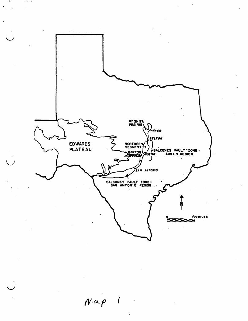
· ,
u
u
EDWARDS PLATEAU
u
u
u
o 1 2 3 4 MILES I ' , , , i • I I o 1 2 3 4 KilOMETERS
B .. fromTua~oI Highways and Pubic Transport"" O...s HipAy mill
Downtown Austin
FIGURE 3. Extent of the. Barton Springs Aquifer (after Slade et al. 1986, Fig. 27).
{
.i (.".
------------~c >
i j
i ike .. " cO. i i i ,.
EDWARDS (Balcones Fault Zone) AQUIFER REGION
I •
i I i RESERVOIR
i
i i I L.
. _-:;...,....
L ~ (' ,...~ "'c'
'",-.-('
(:J
t, t..,.)
( " . ...., ~
~.') \
fi'i' I i i i i
i.-I -cO.-·-4· ... ·_I·_· ... ~/
", ~,/ ~'-q"
,/
I i
/'
/ i
/
--!.. ____ ,t.--I
.~ _-1 ....... i "- ;'
;' i
I/)/\ .... ~ f\ - ~
..------_ .. .,- .~;-,
/
."
'\.,,", ..... \ . \
'<\ \ ~\ ,
\ \
- -- - .'?!!....
.,'
i I
........ . .; ""L~/,
CQ\. \ \
//
'/ ~~ ... / -
/
/ ./
/
t ........... "e" - r •• . -.~
.~"~LUI!U.
" \ \ "\ ~
--------- =,.. .. _,-----_tpu ... _ ---,- -..,.. -"._, .............. ------ _. __ ... .,---
lDWAItOS AQUIfER ItEKAIICIt AltO MYA CENtER IUROCI WIll_Sf ilIA' Sfall .. 'YfRSlII 5 ...... _. 'f'"
1114
... r.
I
I , I
()
N
i Explanation
EI Recharge Zone
o Contributing Zone
county Line
o 1 2 3 4 5 6 miles , , , , , t •
FIGURE 4. The recharge and contributing zones of the Barton Springs Aquifer (after Slade et al. 1986, Fig. 27; Veenhuis ana Slade 1990, Fig. 2).
(I c-'
I PRE - PENNSYLVANIAN
PENNSYLVANIAN AND PERMIAN ROCKS. IN NORTH- CENTRAL TE XAS
[;J .... . .. ,. .. . •• ' •• 0. .....
SAND
~ ~
SHALE
.~
LIMESTONE
~
~~ -,..~ -~
()
:::::::- -::. ~
EVAPORATION
~ ~ 1
CRETACEOUS AND TERTIARY ROCKS, TEXAS GULF COAST
~ ? .. SPRING DIRECTION OF WATER MOVEMENT
c...hQ,-t- ~
-:.
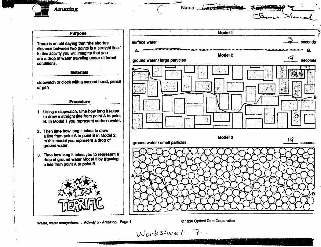
.-- . .... " ....,..;.. , ....
Purpose
There is an old saying that .,he shortest . distance between two points Is a straight line.· In this activity you will Imagine that you are a drop of water traveling under different conditions.
stopwatch or clock with a second hand. pencil or pen
Procedure
1. Using a stopwatch. time how long It takes to draw a straight line from point A to point B. In Model 1 you represent surface water.
2. Then time how long it takes to draw a line from point A to point B In Model 2. In this model you represent a drop of ground water.
3. Time how long It takes you to represent a drop of ground water Model 3 by CkJwlng a line from point A to point B •
. '. ~.1t.'." .•..• '.: :' .:t..;
::. ..~ ••• , Fl." ...... ...... (:}"~ 'K" : '" :V' "'&;'. ': '". \1C . .~ . .- .
C" Name
r---------~--~----~~~--------~----------~" Modal 1 ';:, I
surface water seconds
A. 'AoAoW ............... • 'IJ..I' ..................... , ........ _-......... &:'''!.!.' • :.:,' • :.:.' • ':':':' '!.!.!. • ... u,u.u..a.a.u.a-a B. MocIel2
" ground water 1 large particles seconds
Modal 3 ground water I small particles seconds
Water. water everywhere... Activity 5 - Amazing - Page 1 e 1990 Optical Data Corporation
7-. "

c'
Artesian well
(Af~er Ground Waler and Wells, UOP Johnson Div., 1966)
Water-pressure level (potenliomelric surface, of artesian aquifer
Water-table well
,Flowing , artesian well
(\
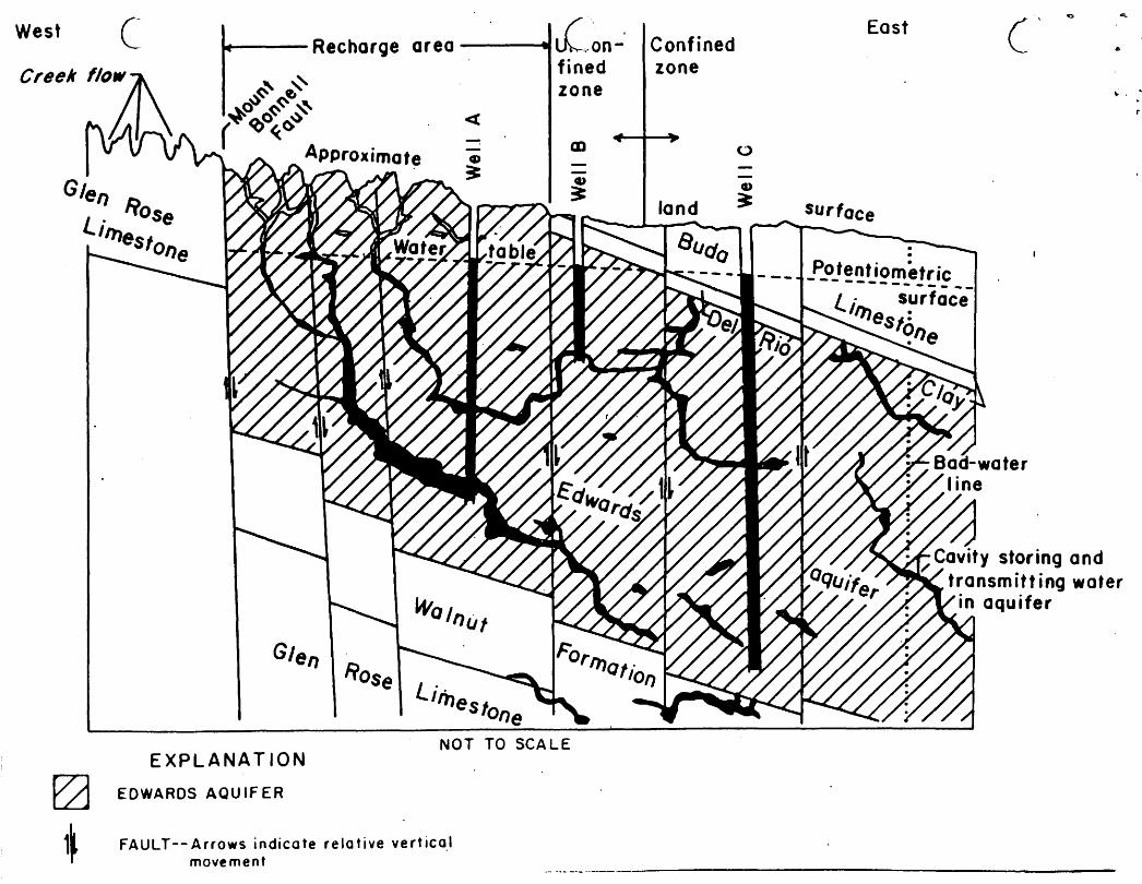
West c ....... ---Recharge area ---..... £,on-'
«
fined zone
m
NOT TO SCALE EXPLANAT ION
EDWARDS AQU IF ER
FA U L T - - A rr 0 W 5 in die ate rei a t i ve ve r tic 0.1 movement
Confined zone
East
\. .

.;
• •
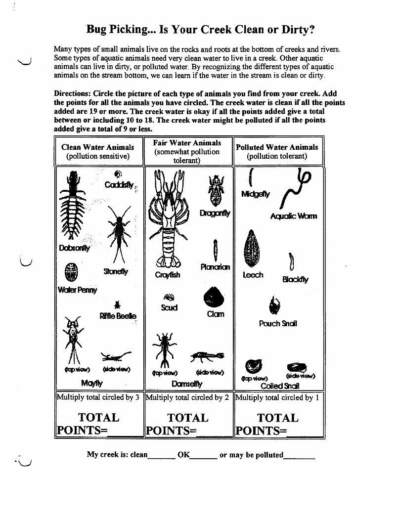
u
Bug Picking ... Is Your Creek Clean or Dirty?
Many types of small animals live on the rocks and roots at the bottom of creeks and rivers. Some types of aquatic animals need very clean water to live in a creek. Other aquatic animals can live in dirty, or polluted water. By recognizing the different types of aquatic animals on the stream bottom, we can learn if the water in the stream is clean or dirty.
Directions: Circle the picture of each type of animals you find from your creek. Add the points for all the animals you have circled. The creek water is clean if all the points added are 19 or more. The creek water is okay if all the points added give a total between or including to to 18. The creek water might be polluted if all the points added give a total of 9 or less.
Clean Water Animals (pollution sensitive)
Fair Water Animals (somewhat pollution
tolerant)
,
Scud Clan
Polluted Water Animals (pollution tolerant)
AtpaicWam
Leech
PouchSncil
Multiply total circled by 3 Multiply total circled by 2 Multiply total circled 1;>y 1
TOTAL POINTS=
TOTAL POINTS=
TOTAL POINTS=
My creek is: c1eao ___ OK ___ or may be polluted __ _

· .
u
I .
~:s;;. ~.-.-.~
23
I
20 I I
/ 21
GROUP TWO TAXA canUnued
10 Scutt 0nJer Amphipoda.l/4: white 10 gey.!:cc"/ higher than H is wide. swims sicEways. Im"!!.~ : legs. resembles small shrimp.
11 A/delf/y /6va.' Family SiaOdae. 1- lOIlJ.locks :~ smaJl hellgrammite but has 1 long, thin. tx'2rcc~: tail at md< end (no tmks). No gill tufts l!ra.~
12 AshOy IatV4 Family CotydaJictJe. Up to 11(Z long. looks like small hellgrammite txJt cf.en a lighter reddIsh-tan color. or with ~lIowist1 5trEa~ No gilllufts uroerreath.
13 Damselfly: Suborder ZYUJptera. 1/2: - l-,lar;; e~s. 6 thin hooked legs. 3 broad oar-shacec ~~. positioned like a tripod. Smooth (no gills) en s~ of lower half of body. (See arrow.)
14 Watersnipe Ry LaIVd: Family AlJ1ericidae (AJte:fx':_ 1/4- -1-, pale to green, tapered body, man"/ caterpillar-like legs, coniml hpad. feathery -mr.s' at back end.
15 Crane Fly: Suborder NemaJorera. 1/3- -'Z. miliiy. green. or light broMl. pltmp caterpillar-li~ segmented body. 4 finger-like lobes at tacK em
1& Beetle lNVd: Or[JerColeoptera 1/4-1·, figtitcolored. Slags on upper tBH of body, feelers, antennae.
17 Dragon Fly: Suborder Anisoptera. 1/2.- -~, Ia";; eyes. 6 hooked legs. Wide oval to round at:Cci.~:"~
18 Clam: Class Bivalvia.
GROUP THREE TAXA Pollution tolerant organisms can be in any QLBlity cf Kater.
19 AQuatiC Worm: Class Oli(;od1aela 1/4- - ~, can De VPJY tiny; thin worm-like body.
20 Midge Fly I.Nva: Suborder Nematocera Up to 1/4-. dark head. worm-like segmented body. 2 tiny le~ on ea:h side.
21 8Ja:ld1y Lav;r Family SimuOf2. Up to 1/4-, one eoo of body wider. Black head. suction pad on enc.
..... 22 Leech: Order Hirudif1P4. 1/4- - 2-, brown, slimy OOdy, ends wilh suction pads.
23 Pouch Snail arrJ Pond Snai/~ Class Gastropoda. No operculum. Breathe air. Shell ustally opens en lefL
24 OIJ1er snails: Class GastrOprxB. No operculum. Breathe air. Snail shell coils in one plane.

· .
u
u
Relevant Vocabulary
aguifer-a penneable, confined, underground geological fonnation that stores, transmits and yields water for consumption. biomonitoring-use the small animals in a body of water to check the health of the area confined or anesian zone- where water is stored under pressure and will ~se above the water line at artificial wells and natural springs contributing zone-the watershed upstream of an aqUifer recharge zone from which nm-off and stream flow are directed towards the recharge zone . dissolved oxvgen-oxygen freely available in water. The most important indicator for the capability of a body of water to suppon life. . ecosvstem-the. natural unit that includes a community of organisms and all of the environmental factors eff~gilieoommunity . erosion-wearing away of rock and soil and removal of that debris eutrophication-process by which a body of water becomes rich in inorganic minerals usually causing excessive algae growth, and the dying of higher life fonns
fecal coliform-a type of bacteria found in animal (including human) waste
!!!I!i!!t-place where all the requirements for an organism to live are met
bumiditv-measure of the amount of water vapor in the air
bvdrology-the study of water; in particular the properties, distribution, and circulation of water on the surface of ilie land, in the ground, and in the atmosphere
impermeable-material that does not pennit liquids to flow through it
impenious cover-SUlfaces that do not allow water to soak through them.
Don-point source pollution-any pollution which can not be traced to one individual source
I!H -a numeric scale that indicates the acidity or alkalinity of a solution. It measures the concentration of hydrogen ioDS. The scale runs from 0-14 with 7 being neutral, lower is acid and higher is basic.
pollution-any substance which restricts or eliminates the use of a natural resource
porous-has l.ots of openings and is penneable to water
recharge zone-land surface with fractures caves or small openings in rock through which rainfall, runoff: and streamflow drain underground into an aquifer, thereby replenishing the water stored there.
turbiditv-amount of panicu1ate matter in suspension
11.14·98 TI.r
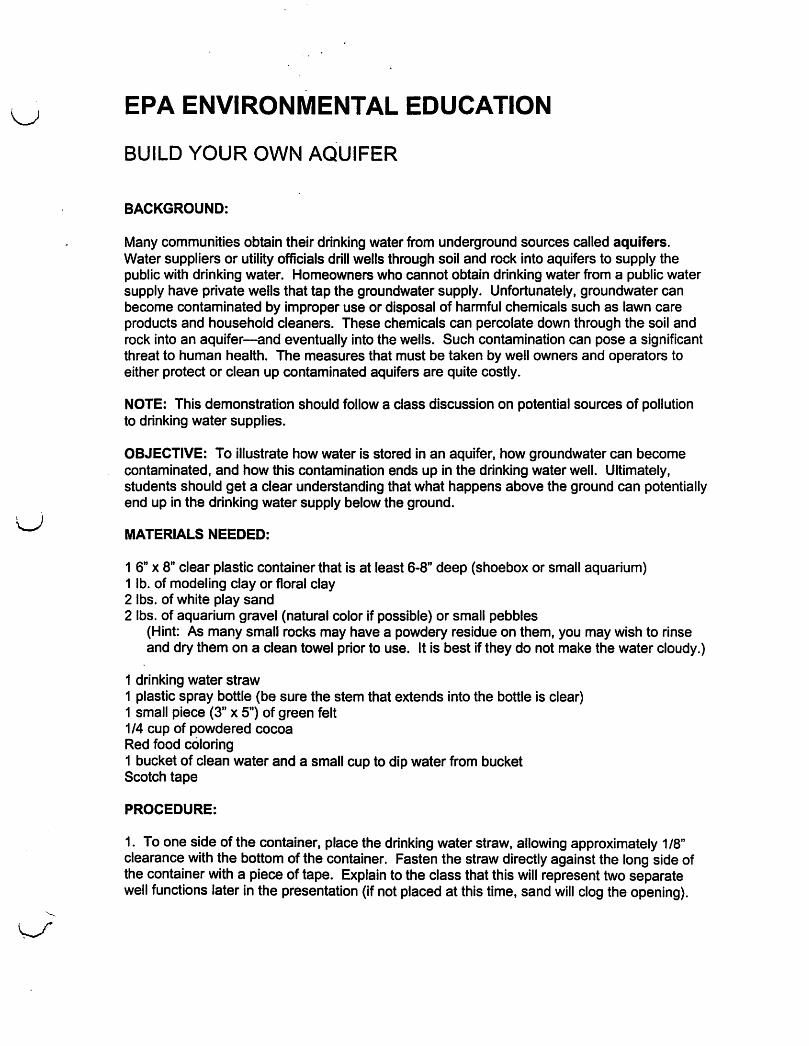
u
u
EPA ENVIRONMENTAL EDUCATION
BUILD YOUR OWN AQUIFER
BACKGROUND:
Many communities obtain their drinking water from underground sources called aquifers. Water suppliers or utility officials drill wells through soil and rock into aquifers to supply the public with drinking water. Homeowners who cannot obtain drinking water from a public water supply have private wells that tap the groundwater supply. Unfortunately, groundwater can become contaminated by improper use or disposal of harmful chemicals such as lawn care products and household cleaners. These chemicals can percolate down through the soil and rock into an aquifer-and eventually into the wells. Such contamination can pose a significant threat to human health. The measures that must be taken by well owners and operators to either protect or clean up contaminated aquifers are quite costly.
NOTE: This demonstration should follow a class discussion on potential sources of pollution to drinking water supplies.
OBJECTIVE: To illustrate how water is stored in an aquifer, how groundwater can become contaminated, and how this contamination ends up in the drinking water well. Ultimately, students should get a clear understanding that what happens above the ground can potentially end up in the drinking water supply below the ground.
MATERIALS NEEDED:
1 6" X 8" clear plastic container that is at least 6-8" deep (shoebox or small aquarium) 1 lb. of modeling clay or floral clay 2 Ibs. of white play sand 2 Ibs. of aquarium gravel (natural color if possible) or small pebbles
(Hint: As many small rocks may have a powdery residue on them, you may wish to rinse and dry them on a clean towel prior to use. It is best if they do not make the water cloudy.)
1 drinking water straw 1 plastic spray bottle (be sure the stem that extends into the bottle is clear) 1 small piece (3" x 5") of green felt 1/4 cup of powdered cocoa Red food coloring 1 bucket of clean water and a small cup to dip water from bucket Scotch tape
PROCEDURE:
1. To one side of the container, place the drinking water straw, allowing approximately 1/8" clearance with the bottom of the container. Fasten the straw directly against the long side of the container with a piece of tape. Explain to the class that this will represent two separate well functions later in the presentation (if not placed at this time, sand will clog the opening).
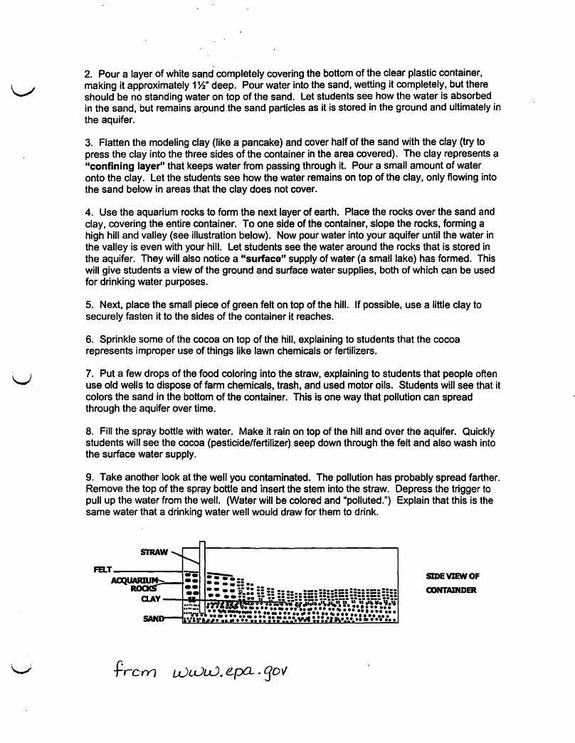
2. Pour a layer of white sand completely covering the bottom of the clear plastic container, making it approximately 1 %" deep. Pour water into the sand, wetting it completely, but there should be no standing water on top of the sand. Let students see how the water is absorbed in the sand, but remains arpund the sand particles as it is stored in the ground and ultimately in the aquifer.
3. Flatten the modeling clay (like a pancake) and cover half of the sand with the clay (try to press the clay into the three sides of the container in the area covered). The clay represents a "confining layer" that keeps water from passing through it. Pour a sma" amount of water onto the clay. Let the students see how the water remains on top of the clay, only flowing into the sand below in areas that the clay does not cover.
4. Use the aquarium rocks to form the next layer of earth. Place the rocks over the sand and clay, covering the entire container. To one side of the container, slope the rocks, forming a high hill and valley (see illustration below). Now pour water into your aquifer until the water in the valley is even with your hill. Let students see the water around the rocks that is stored in the aquifer. They will also notice a "surface" supply of water (a sma" lake) has formed. This will give students a view of the ground and surface water supplies, both of which can be used for drinking water purposes.
5. Next, place the small piece of green felt on top of the hill. If possible, use a little clay to securely fasten it to the sides of the container it reaches.
6. Sprinkle some of the cocoa on top of the hill, explaining to students that the cocoa represents improper use of things like lawn chemicals or fertilizers.
7. Put a few drops of the food coloring into the straw, explaining to students that people often use old wells to dispose of farm chemicals, trash, and used motor oils. Students will see that it colors the sand in the bottom of the container. This is one way that pollution can spread through the aquifer over time.
8. Fill the spray bottle with water. Make it rain on top of the hill and over the aquifer. Quickly students will see the cocoa (pesticide/fertilizer) seep down through the felt and also wash into the surface water supply.
9. Take another look at the well you contaminated. The pollution has probably spread farther. Remove the top of the spray bottle and insert the stem into the straw. Depress the trigger to pull up the water from the well. (Water will be colored and "polluted.") Explain that this is the same water that a drinking water well would draw for them to drink.
SIDE VIEW OF
OONTAINDER
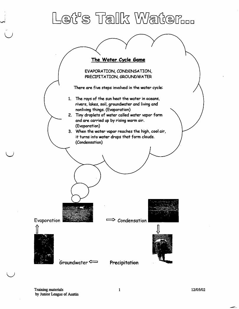
u
u
u
Evaporation
it
EVAPORATION, CONDENSATION, PRECIPITATION, GROUNDWATER
There are five steps involved in the water cycle:
1. The rays of the sun heat the water in oceans, rivers, lakes, soil, groundwater and living and nonliving things. (Evaporation)
2. Tiny droplets of water called water vapor form and are carried up by rising warm air. (Evaporation)
3. When the water vapor reaches the high, cool air, it turns into water drops that form clouds. (Condensation)
~~~~~ii~ .or ..... r- ~ ~.~r~~· .
~ Condensation I
Groundwater ¢::::::J Precipitation
Training materials 1 by JwriorLeague of Austin
12/05/02

Now that we have played the game .. .let's go visit Barton Springs Pool and learn a little bit about why the pool is so important to us ...
Training materials 2 12/05/02 by Junior League of Austin
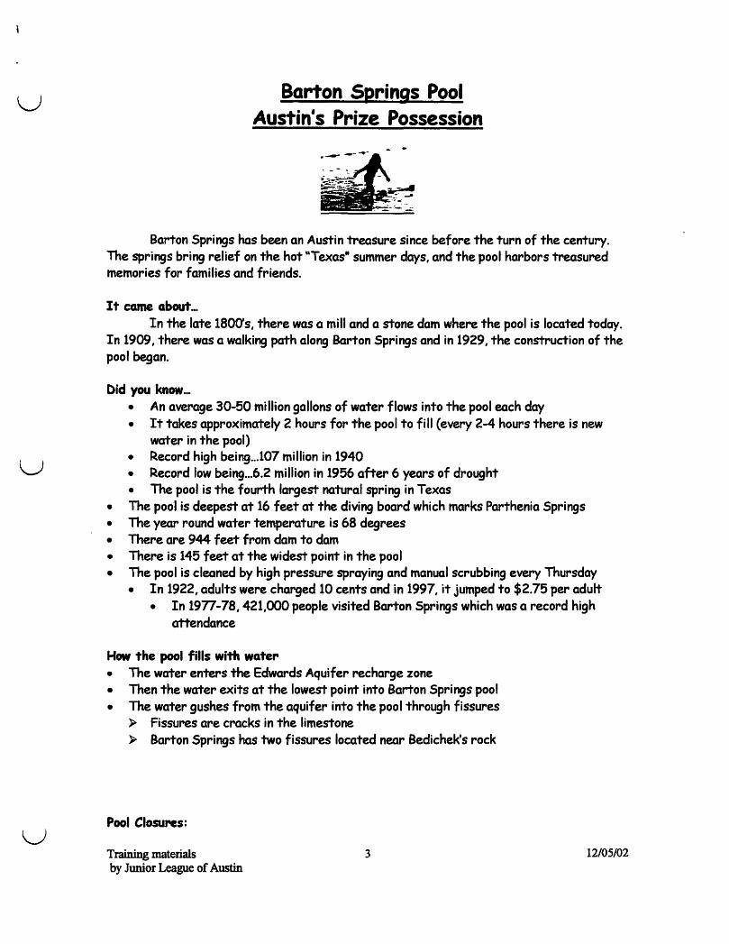
u
u
u
Barton Springs Pool Austin's Prize Possession
Barton Springs has been an Austin treasure since before the turn of the century. The springs bring relief on the hot "Texas· summer days, and the pool harbors treasured memories for families and friends.
It came about_. In the late 1800's, there was a mill and a stone dam where the pool is located today.
In 1909, there was a walking path along Barton Springs and in 1929, the construction of the pool began.
Did you know ... • An average 30-50 million gallons of water flows into the pool each day • It takes approximately 2 hours for the pool to fill (every 2-4 hours there is new
water in the pool) • Record high being .. .107 million in 1940 • Record low being ... 6.2 million in 1956 after 6 years of drought • The pool is the fourth largest natural spring in Texas
• The pool is deepest at 16 feet at the diving board which marks Parthenia Springs • The year round water temperature is 68 degrees • There are 944 feet from dam to dam • There is 145 feet at the widest point in the pool • The pool is cleaned by high pressure spraying and manual scrubbing every Thursday
• In 1922, adults were charged 10 cents and in 1997, it jumped to $2.75 per adult • In 19n -78, 421,000 people visited Barton Springs which was a record high
attendance
How the pool fills with water • The water enters the Edwards Aquifer recharge zone • Then the water exits at the lowest point into Barton Springs pool • The water gushes from the aquifer into the pool through fissures
» Fissures are cracks in the limestone » Barton Springs has two fissures located near Bedichek's rock
Pool Closures:
Training materials 3 by Junior League of Austin
12/05/02

• The pool closes when fecal coliform bacteria (found in the digestive tracts of humans and animals), pesticides, nitrogens, and other pollutants are washed into the recharge zone. This happens frequently after heavy rains.
• In 1974, the city closed the pool to build Q floodwater bypass. This would redirect the water flowing down Barton Creek through a culvert, under the sidewalk and to the dam at the other end of the pool.
» This keeps the pool free from mud and debris ~ It keeps the temperature at 68 degrees year round
Training materials 4 12/05/02 by Junior League of Austin
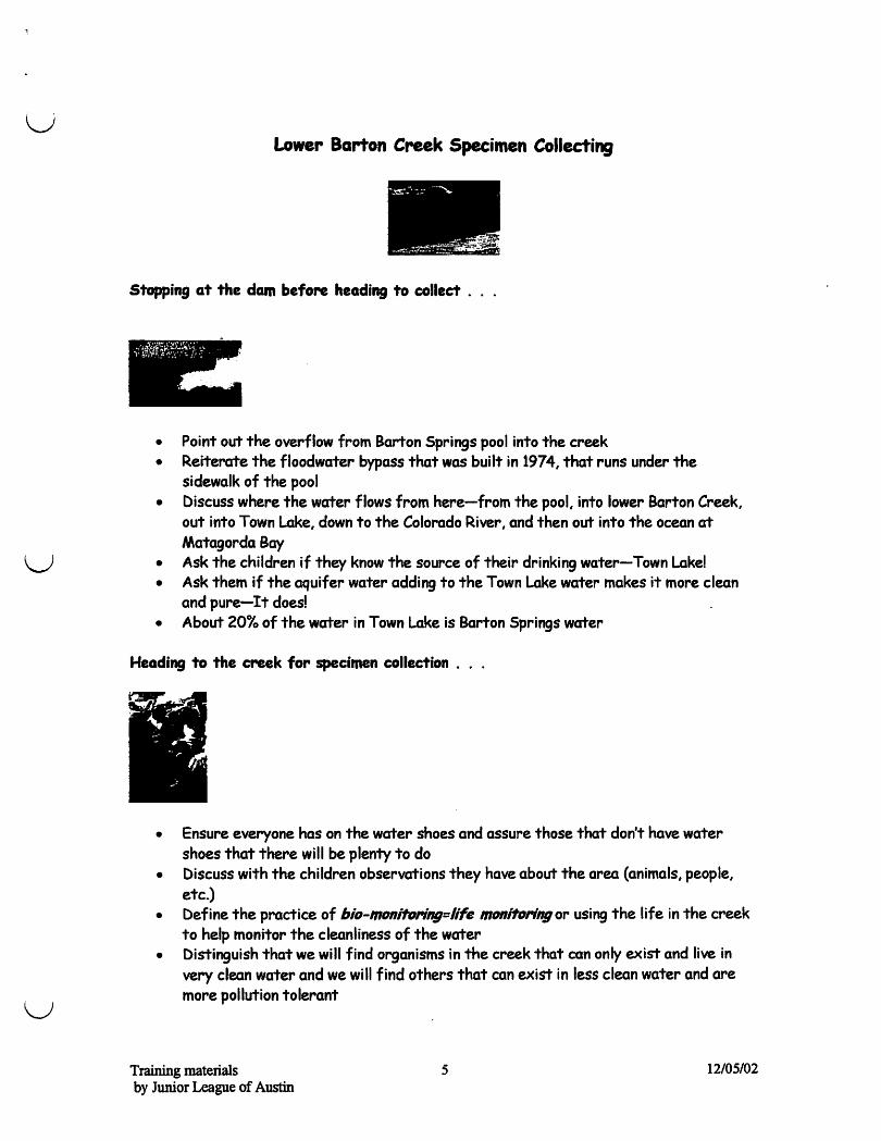
u
u
u
Lower Barton Creek Specimen Collecting
-~.-. -:;: --.~
--..,~~:f!5'1;;'". _ . ,.~"
Stopping at the dam before heading to collect .
)':·!j~f~~V~(F:;, .
,
• Point out the overflow from Barton Springs pool into the creek • Reiterate the floodwater bypass that was built in 1974, that runs under the
sidewalk of the pool • Discuss where the water flows from here-from the pool, into lower Barton Creek,
out into Town Lake, down to the Colorado River, and then out into the ocean at Matagorda Bay
• Ask the children if they know the source of their drinking water-Town Lakel • Ask them if the aquifer water adding to the Town Lake water makes it more clean
and pure-It doesl • About 20% of the water in Town Lake is Barton Springs water
Heading to the creek for specimen collection ...
• Ensure everyone has on the water shoes and assure those that don't have water shoes that there will be plenty to do
• Discuss with the children observations they have about the area (animals, people, etc.)
• Define the practice of biD-mDnift»eing=life mDnittJringor using the life in the creek to help monitor the cleanliness of the water
• Distinguish that we will find organisms in the creek that can only exist and live in very clean water and we will find others that can exist in less clean water and are more pollution tolerant
Training materials byJwriorl£agueof~
5 12/05/02

• The primary focus is on collecting macro-invertebrates which are small organisms that CAN be seen with the human eye and are enhanced under the microscope unlike organisms that may also exist in the creek which we cannot see with our naked eye but ONLY under a microscope
• Encourage exploration
Training materials 6 12/05/02 by Junior League of Austin
u The Edwards Aquifer Region
The Edwards Aquifer is the porous, honeycombed formation of the Edwards and associated
limestones. There are three parts: the Contributing Zone, the Recharge Zone and the Confined Zone, which is the Artesian Reservoir Area.
How the Aquifer works: • Rainfall in the Contributing Zone infiltrate the cavernous water table aquifer and it
forms spring fed streams that flow downhill. • Once the water reaches the Recharge Zone (which is the cracked and broken boundary
between the Edwards Plateau and the Artesian AqUifer) then it runs directly down in the ArtesianlReservoir Area of the Aquifer. Recharge dams slow storm runoff over the Recharge Zone so more of it runs into the Aquifer.
• Flowing Artesian wells and springs exist where hydraulic pressure is sufficient to force the water up through wells and faults to the surface.
Facts about the Aquifer: U · The recharge zone is at the base of the Balcones Escarpment, separating two
u
physiographic regions - the Edwards Plateau to the north and the Gulf Coastal Plain to the south
• The Plateau ranges in altitude from about 1,000 to 2,300 feet above sea level. • The topography is rough and rolling and is commonly referred to as the Texas "Hill
Country.-• Vegetation is primarily woodland comprised of oak, mesquite and cedar. • The recharge zone is 1,500 sq. mi Ie area of fractured and cavernous limestone called a
Karst Formation. (Edwards Limestone) • The Edwards Aquifer (southern segment) in the San Antonio area is one of the most
productive aquifers in the southwestern United States. • The Aquifer is about 180 miles long extending from Bracketville to Kyle, Texas and
varies from 5-30 miles in width. • The San Antonio Aquifer supplies nearly all of the water for municipal, domestic and
agricultural needs. • In 1959, the Edwards Underground Water District was created to protect, preserve &
conserve that resource in San Antonio. • The Edwards Aquifer is one of the largest sale source aquifers in the country and the
first to be designated by the U.S. Environmental Protection Agency. • About 85'D of precipitation falling on the area is lost back to the atmosphere by
evaporation due to warm temperatures or transpiration of water vapor from vegetation.
Training materials 7 12/05102 by Junior League of Austin
Other Interesting Things Around the Pool
• "Bedichek's rock-: this rock was named after Texas writers Roy Bedichek, a naturalist, J. Frank Dobie, a folklorist and chronicler, and historian Walter Prescott Webb (the non-swimmer in the trio) who enjoyed contemplating life on this rock's ledge. There is a statue dedicated to these "rock sitters- at the entrance of the bathhouse.
• "Eliza Spring-: A.J. Zi Iker bui It the structure around Eliza Spring in 1903, as a meeting place for the Elks' club. YetJrS ago when Barton Springs pool was lowered for cleaning, the salamander would get trapped in Eliza Spring and die. This is one of the reasons why Barton Springs pool is not lowered any longer for cleaning and other methods have been employed for the removal of the algae from the pool's sides and bottom. (There are plans to renovate the spring for public use again.)
• "Parthenia Spring-: named after one of settler William Barton's daughters, and is the largest and main spring at the pool. This spring is known as the heart of the pool. The Barton Springs salamander is found frequently at the mouth of this spring.
• Sunken Gardens is the 3rd spring in this area and is down past the pool and similar in size to Eliza spring. The Sunken Gardens is also known as Zenobia - who is Barton's daughter.
Training materials 8 12/05/02 by JuruorLeague of Austin
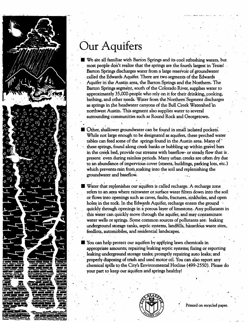
. Our Aquifers .We are all familiar with Barton SQrings and its cool refreshing wat(!rs, but
most peo~ledQn't realize that the springs are the fourth largest in Te~as! 'Barton Springs discharges w~ter fro~ a large reservoir of gr~undwater called the Edwards Aquifer. There are tWo segments of the EdwardS , Aquifer iri the' Austin aJ;ea, the Barton Sptillgs and the Northern. The Bartc;>n Springs segm~n~, south of the Colorado River, supplies water to approximately 35,00b~people who rely on it for their drinking,_cooking, bathing, and other needs. 'W~ter from the Northern Segment discharges as'springs inihe he.adwa~er canyons of the Bull Creek Watershed 1n northwest Austin. Thjs ~egment also supplies w~ter to several surrounding communities such as Round Rock and Georgetown.
. . .. • Other, shallow(!r groundwater can be found in small isolated pocketS.
While not large enough to be designated" as aqu'ifers, these 'perched water tables can feed some of the springs: found in the Austin area. Many of" ' these sPrings, Jound ~ong creek banks or bubbling up within gravel b~ in the creek bed, provide our streams with baseflow .. or'steady flow that is. present ' ~~en during rainleSs periods. Many urban creeks are 'often dry due 'to an ~buncfance of impervio~ cover (streets, buildings, parking lots, e'tc.) which preven~.rain, froril..$Qaking into the soil and replenishing the groun~water and',baseflow.,
• W~ter ~t rep!enishes our aqqifers i,s' called r~charge. A recharge zone , refers to an .ate a where rainwater or, surface water filters down into the soil' ,or flows' into openings such as caves, fa~lts, fractures, 'sinkholes, and ,open holes_ iti. the rock. In the Edwards Aquifer, recharge enters the ground '" quickly through,'opening~ in ~ porous layer of limeston~. Any poliu'tants in this water can quickly move thro~gh the aquifer, and may contaminate water wells or springs. Some common so~rces of.pollutants ~~e: leaking underground storage tanks, septic systems, landfillS, hazardous waste sites, , feedlo~, automobiles, and residenti~llandscapes. ,
• You can help protect our aquift:rs by appiying lawn chemicals tn appropriat-e amounts; repairing leaking septic systems; fixing or reporting leaking undergr<9und storage tanks; promptly repairing auto leaks; and ' properly disposing of trash and used motor oil. You can also report any ~hemical Spills t<? the City's Environmental Hotline (499 .. 2550). Please do your part to keep our aquifers and springs healthy! '
~rinted on recycled paper.

, ! OurWat~rsh~ds· . .. _ . . '. .. .~. • ' Situated on the' bo~dary .between the Texas Hill .. eo"untty to the west and prairi~ri : , . lands to the east, Austin is at the crossroads of two distinct and dive~ ecosystems: /
Native:Americans were attracted tb this area because of the abundance Qf water . "and the diversity of natural resources, as were early European settlers. Austin's . ,
creeks p~ovided these settlers with water, food,' energy, and relief from our Ce~tral Texas heat~ Today, our creeks still serve some of the same jmpOrtant. functions. . . They contribute water ~o Austin's drinking water supply,' provide Atistinites With '
" recreational opportunities, serve as wildlife habitat, and drain floodwaters from our ". neighborhoods. These-creeks 3l'~ ~ integral part of our natural environment arid
a cOntrihutor to oUr uniql:le 'A~tin life .. style. . -i· I' r r,
'. Right now,.if you'looked: out' your window, you might see lots of concrete: your. o • ,driveway, sidewalks, the street and curbs. This' is what's called impervious cover.
Ii: came gradually, with urbanization, and ies made quite 'a difference in the'health , of your creek. That's right, You have a creek! Your home is located in one of the .' ar~a's 45 creek wa~ersheds. A watershed is the entire 3l'ea of land that drains .to a creek, river or lake. You can use the enclosed map to find out~where your
. watershed is. .
• Many years ago, your property was natural and und~veloped. IWnfalllanding' ~n .. ) . your property· ran off slowly over the native vegetation ana ,was ab$orbed into the, r. ~
, earth. Today's rainfall lands on hard surfac~ like your'driveway, sidewalk, roof,' ( ) . '. street and curb (your property'~ imperVious cover) and '1UIlS directli into a ~storm
-sewer and into a creek. This increased stormwater now drains much more quickly ....' than it .used to, 'altering your creek's natural ecosystem and increasing the likeli ..
hood that pollutants will enter your creek. These pollutants, not easily traced to one particular sOurce, are called nonpoint source pollution: Some common types of nonpoint source pollutants .that homeowners generate are fert~lizer, pesticides,' ,
. motor oil and car waSh soap. •
.• ' I~ some newer 'areas' of Aust~, builders are required to install water quality c6ntr~1 structures. These strucq.rres cari limit the degree to which a creek is' polluted by developJllent. Since many of Austin's residential neighborhoods were built before
_ ,the City required' dl~e structures, it's very important fo~ you to take small mea.. ~ . : sures at home to reduce the.am.ount of pollution you contribute to our waterways. · Please read the. enclosed brocliures to learn more about reducing the amount of
.nonpoint source pOllution that you and your family produce. Thank you .for your intereSt ~ keeping Austin a great place to live.
. Printed on recycled paper. -
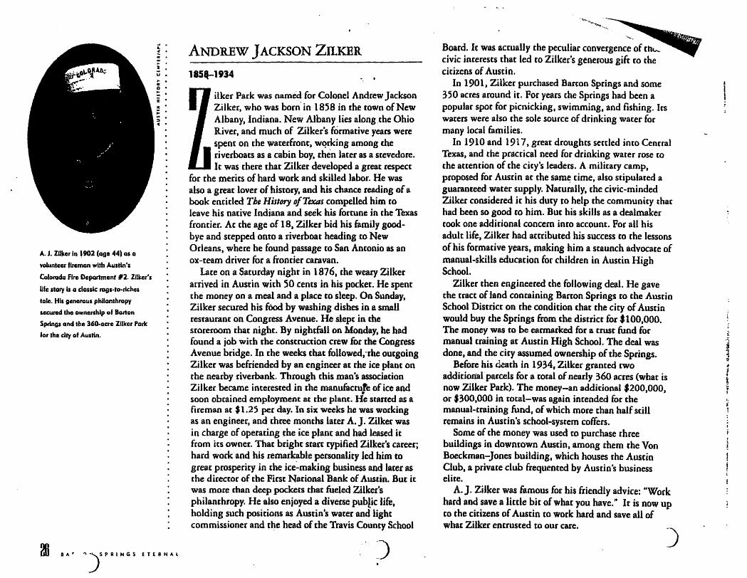
A. J. ZUker 111 ,902 (Q91 44) os 0
Yolunteer fbeman with Austin's
Colorado Fire DCPQrtmont 112. ZUker's
life story Is Q classic rags-to-riches
tole. His generous philanthropy
sGCUr'Cld tho ownership of Bolton
Springs and tho 36o.acre Zilker Park
for the city of Austin.
D ... r ")5 P R I H G 5 E T £ Il N ... L
ANDREW JACKSON ZILKER
18511-1934
ilker Park was named for Colonel Andrew Jackson Zilker, who was born'in 1858 in the town of New Albany, Indiana. New Albany lies along.the Ohio R.iver, and much of Zilker's formative years were spent on the waterfront, wqrking among the riverboats as a cabin boy, then later as a stevedore. It was there that Zilker developed a great respect
for the merits of hard work and skilled labor. He was also a great lover of histOry, and his chance reading of a book entided The History of Texas compelled him to leave his native Indiana and seek his fortune in the Texas fronrier_ At the age of 18. Zilker bid his family goodbye and stepped onto a riverboat heading to New Orleans, where he found passage to San Antonio as an ox-team driver for a frontier caravan.
late on a Saturday night in 1876, the weary ZUker arrived in Austin with SO cents in his pocket. He spent the money on a meal and a place to sleep. On Sunday, Zilker secured his fOod by washing dishes jn a small restaurant on Congress Avenue. He slept in the storeroom that night. By nightfall on Monday, he had found a job with the construction crew for the Congress Avenue bridge. In the weeks that followed •. the outgoing Zilker was befriended by an engineer at the ice plant on the nearby riverbank. Through this mao's association Zilkec became interested in the manufacture of ice and • soon obtained employment at the plant. He sraned as a fireman at $1.25 per day. In six weeks he was working as an engineer. and three months later A. J. ZUker was in charge of operating the ice plant and had leased it from its owner. That bright statt typified Zilker's career; hard work and his remarkable personality led him to great prosperity in the ice~makjng business and later as the director of the First National Bank of Austin. But it was more than deep pockets tbat fueled ZUker's philanthropy. He also enjoyed a diverse public life, holding such positions as Austin's water and light commissioner and t~e head of the Travis County School
Board. It was actually the peculiar convergence of th", ...
civic interests that led to ZUker's generous gift (0 the citizens of Austin.
In 1901, Zilker purchased Barton Springs and some 350 acres around it. For years the Springs had been a popular SpOt for picnicking. swimming, and fishing. Its waters were also the sale source of drinking water for many local families.
In 1910 and 1917, great droughts senled into Cenrral Texas, and the practical need for drinking water rose [0
the attention of the city's leaders. A military camp, proposed for Austin at the sam~ rime, also stipulared a guaranteed water supply. Naturally, the civic-minded Zilker considered it his duty to help the community [har had been so good to him. But his skills as a dealmaker took one additional concern into account. For all his adult life, Zilker had actributed his success to the lessons of his formative years, making him a staunch advocate of manual-skills education for children in Austin High School.
ZUker then engineered the following deal. He gave the tract of land containing Barton Springs to the Austin School District on the condition that the city of Austin would buy the Springs from the district for $100,000. The money was to be earmarked for a trust fund for manual training at Austin High School. The deal was done, and the city assumed ownership of the Springs.
Before his ci~ath in 1934, Zilker granted two additional' parcels for a total of nearly 360 acres (what is now ZUker Park). The money-an additjonal $200,000, or '300,000 in total-was again intended for the manual-training fund, of which mote than half still remains in Austin's school-system coffers.
Some of the money was used to purchase three buildings in downtown Austin, among them the Von Boeckman-Jones building, which houses the Austin Club, a private club frequented by Austin's business elite.
A.J. Zilker was famous for his friendly advice: "Work hard and save a little bjt of what you have." It is now up co the citizens of Austin to work hard and save all of what ZUker entrusted to our care.
)
(
18 8ARTON SPRINGS ETERNAL
WILLIAM "UNCLE BILL' (lRTON
1782-1840
n 1837. when William Barmn and his family settled ~t the Jarge freshwater spring that would later bear his name, his nearest neighbor witS Reuben Hornsby, eleven miles away at Hornsby's Bend. The Barton party had moved to Texas nearly ten years earlier wirh Srephen F. Austin and had "taken·' their league" near Bastrop. But later. when another family moved
within earshot, old man Barton decided toputl out and moved upriver to a more private spot. So, when William Barton's eldest son, Wayne, returned victorious from the Baule of San Jacinto. Texas was a free republic, the Mexican general Santa Anna was a prisoner. and the Barron family was on the move.
All £old. there were three springs grouped within a shorr distance of the cabin Banan built overlooking the main hole of Spring Creek (as it was known then). Old man Banon named these springs after his three daughters, Parthenia, Eliza. and Zenobia. The names never stuck, however, and the place has been called Barton Springs ever since. These three springs remain today as Barton Springs pool, the nearby Elks Pit (fenced off near the current concession stand), and the Sunken Garden (downsrream from the pool on the south bank).
If Barton had any designs on solitude at his new home. they were' to be dashed by greater designs on the sleepy settlement of Waterloo. which Jay just across the river. Waterloo, Texas, wasn't so much a town in those days as a frontier outpost, with a few small cabins and a single large one surrounded by a split-log stockade for Indian protection. Indian raids were a real chreat to the Texas settlers in those days, just as the settlers' encroachment was a real threat to the continued existence of the Indians. Uncle Billy Bacron came to be known as a great Indian fighter 86 .he fallewift8 seo19 \Oas Fussed . gB~'A dUQuf)k 8181'ltieR' +1.. "el8islI' here js adapted
(r-Ona month after brothers WiUlam and Elisha Barton each rueJved headright grants from the MoxJcan govemment and purduasad 4,421
acral for $155, an exultant Elisha wrote af hll purchas. to family back
In South Carollno:
Brother, sitch land as it is yolt never saw. It is a high, dry, healthy country and much healthier than any part of Alabama . ...
There are a great many deer in this colony. 1 can see at one sight sometimfJI more than 300. There are (aho) many good buffalo, and wild cows run at this time witbin ten miles of where I litle. There is an enormolls sight of wild horses within four miles of where I live.
Brother William and his family are here and
he has gOI him jllst as milch land as I have. Brother, 1 never expect to see any of you again,
still 1 will write to you al milch as once a y84t', if I should live. I can, at almosl any time, send a letter from here 10 the United States by someone thai is passing. 1 am living 15 miles ab01le where William litles, five miles below where the St. Antone Road crosses it . ...
So no more bill remains your brother till death.
. Farewell,' Elisha Barlon May 2nd, 1831
)
Spring Creek is a strUl7n 0/ eighleen miles in length, whirb enJers tbe Colorado from the u'esl, one mile aho"e the City 0/ Auslin. II rises in the mountains, and after r/~'ming a few III;/es, almosl disappears: 'bul about one mile from the ri"er, al a place failed BartOli's springs, il is again supplied by waler, by four large springs, wbub supply a dream of sixty feet in widlb and four foel deep, and rUllS wilb a brisk currenllo Ibe river. A company lire about ereeling a mill III Ibis pl",e. A por,;on o/Ibe land towards Ibe bead of Ibis ,reek is broken and hilly, bUI of ri,b qualily, and weJI supplied wilb limber. It bas extensive, rich, and beautiful valleys, and some exee/lent table land upon tbe bills. Towards Ihe moulh il runs througb II &ounlry
beautifully undulaling, rkb and 4greeably interspersed with woodland and prairie.
. George W. Bonnell
Topographical Description of Texas. 1840
18
Bonnell come to Texas in 1836
to fight in the revolution. He
begon this report os the commissionpr of Indian Affairs under Sam Houston.
GARTON SPftlNGS ETERNAL
When stories of Barron's dan8~rous outptJ .... kade their way to the Texas government at Washington on the BrazosJ soldiers were posted at the Springs for the family's protection. "In no time." wrote Brown. "Uncle Bjity wrote President Houston to come get his blasted soldiers or he would sic the Indians on them. (It was more trouble to keep the soldiers away from his daughters than it was co fight the redskins.)"'
On April 13. 1839. the Republic of Texas began the search for a new capital city, and a survey committee selected [he town of Waterloo. In a letter to Miraheau B. lamar. the selection comminee cited Waterloo's central location in the new republic plus its abundanc~ of fine water. fertile land. building stone, and other .. desideratims of health.·· Included in their praise was nearby Spring Creek (at Banon Springs), which afforded "the greatest and most convenient flow of water to be found in the Republic."
Indeed. William Barron's spring was soon to furnish chac convenient flow to the city of Austin, whose records reveal thac in December 1839, Barton agreed to "give possession of stream of water from my Big Spring" to furnish power for a sawmill. It was the first of various mills to take advantage of the dependable flow. so marking the dawn of.the industrial era in the new republic. But before the pulsing spring was ever harnessed. Uncle Billy Barton died on Aprilll, 1840. His body was buried near his springs and later moved by his family to a less pubUc spot in nearby Round Rock.
) .... . . ~'::'
-) ...... 9' •.••. -. '1:"'-~~!.""'.:t::Mi:C.~.F.'~~~l!;li~"I!a:1;'I!!IIII'IiII~_IIiI! •• IIIJ5_1L \ ' . .. . ...... . .\. . ., . .... . ....
Tragedy at Barton Springs
On the first day of August 1842. George M. Dobon
and John R. Black. cwo young men tben residing at
Austin, concluded to 80 to B~on creek to bath in the
cool water. Friends warned rhcm. before leavin,. of the
danger attendins the trip, as Indians were numerous in
the country about Austin and made frequent incursions in
to the village and its vicinity in queat of booty and scalps.
They expressed rhemselves as feeling safc, remarking Ihal
they were mounted on fleet horses and could easily out
run the ponies of any Indian mal'a~ders that miaht be
encountered •... Dolson and Black crossed the river at the
ford neal' tbe mouth of Shoal creek .•. and proceeded to
the aeek. near the spring. about half a mile above its mouth. About two hours after leaving town tbeir horses
came back riderless. ~wimminB the river above tbe ford.
One of them had an arrow sricking in the rear of the
saddle. The worst was feared. The few men tben in me vill8Jc ol'pnized a 5C8I'Ching party and wen I: to tbe creek.
There diey found tho 4ead bodies of the two men, not far ap~ showing they )lad been tunbushed, killed otudshr, sQllped and stripped of their clochiog .••• These two
young men were noble specimell$ of manhood, beloved by all, and their unamely and trasic end was. rhe Bource of sincere sorrow to the Unle community, who could not well afford to spare ,bem.
PcankBl'oWR
Aflll4h o/Tr""is Cou,,'y "ad Iho City 0/ Atnll" 1875
-).
The Edwards Aquifer and the Great Springs of Texas
The Edwards Aquifer is an irreplaceable natural resource. This natural underground reservoir is the sole source of dri~iD~ water for over I.~ million Central Texans, including the ~ity of San Antonio, and is the source of the largest 0 sprIngs m Texas. The aqUIfer and the flows from these Great Spnngs also provide necessary habitat for over fifty specie!, of plants and animals that live in Central Texas and nowhere else in the world. In turn, spring flows provide essential fresh water for river and estuary ecosystems downstream. The first step in protecting these invaluable water resources is knowledge. Use this map as a handy reference.
The Edwards Aquifer is a karst limestone aquifer, characterized by a system of fractures. faults, open channels, sinkholes, and caves through wh ich water flows rapidly, and by a thin to nonexistent soil cover. These characteristics allow for only minimal filtration of contaminants; thus the aquifer is particularly vulnerable to contamination from human activities on the surface. The aquifer has three segments. These segments-the Northern, Barton Springs (shown in purple), and Southern or San Antonio Segments-are hydrologically distinct; water is not exchanged between them under Donnal flow conditions. Each segment has three zones. In the Recharge Zones, shown in dark green and dark purple, the porous Edwards limestone is exposed to the surface, allowing rainfall and streamflows (and any pollutants they carry) fO plunge directly into the subsurface system of caves and channels that makes up the aquifer. The Contributing Zones, shown in lighter green and purple, consist of the upstream watershed areas of all the streams that drain to and flow across the Recharge Zones. The Artesian Zones, shown in blue, make up the aquifer's underground reservoirs. In the Artesian Zones, overlaying geologic fonnations separate the aquifer from the land surface. The Contributing and Recharge Zones together compose the aquifer's watershed; the Recharge and Artesian Zones compose the aquifer itself.
Seven of the twelve largest springs in Texas flow from the Edwards Aquifer. Ranked by historic rates of flow, they are: Cornal (largest), San Marcos (2nd), Barton (5th), San Antonio (6th), Hueco (7th), Las Moras (lIth), and Salado (12th). The third .. and fourth .. largest springs, Goodenough and San Felipe, issue from the related Georgetown limestone in Val Verde county. Goodenough Springs was covered by the waters of Lake Amistad in 1968; San Felipe Springs is the sole source of water for the city of Del Rio.
I
Archeological evidence indicares that f!1ese large springs hfl':e been the focus of human .activiti since man first came to ~ this area; cities and towns have now grown up around all of them.. Proximity to Barton Springs was a major factor in the ' decision to locate the new capital of the Republic of Texas at Austin in 1839. Spanish missionaries settled at what is now San Antonio in the early 1700s because of the abundant water supplied by San Antonio and San Pedro Springs.
Unfortunately, excessive pumping from the Southern Edwards has severely reduced spring flows. Since the drought of the 1950s, flows from San Antonio and San Pedro Springs have been declining and erratic due to increased pumping; at times, they cease flowing altogether. The recreational value ofBrackemidge Park and the San Antonio Riverwalk is now maintained by well water pumped into the San Antonio River downstream from San Antonio Springs. And in the fall of 1996, after several years of withdrawals from the aquifer exceeding its recharge, the two largest springs in Texas, Comal and San Marcos, came perilously close to drying up.
While pmnping is currently the most seriouS threat to the So~em Segment of the aquifer, contamination is the greatest threat to the Barton Springs and Northern Segments. The Barton Springs Segment has been identified by state water . officials as the Texas aquifer most vulnerable to pollution due to its relatively smalJ size and high porosity and the high development activity in its Recharge and Contributing Zones in southwestern Travis and northern Hays Counties. The Northern Segment is also experiencing heavy development activity in northern Travis and southern Williamson Counties. Increased impervious cover-the total area of roads, parking lots, sidewalks, rooftops, and other impermeable surfacesleads to increased contaminant loads in rainfall runoff from developed areas; scientists have shown that a relatively low percentage of impervious cover (10% to 15%) can bring about irreversible damage to ~e quality of streams. Since streams flowing across the Contributing and Recharge Zones resupply the Edwards Aquifer, preservation of high water quality in these streams is critical to maintaining the quality of water in the aquifer.
For more information, or to join in efforts to protect the aquifer, please contact the organizations listed below.
HiD Country Foundation . Save Our Springs Alliance San Marcos River FouDdatioD P.O. Box 685075 P.O. Box 684881 . P.O. Box 1393 Austin, Texas 78768 Austin, Texas 78768 San Marcos, Texas 78666 512-478-5743 512-477-2320 512-357-6897
www.sosaIliaDce.org • -.-"
Val Verde
•
Nolan Taylor Callahan
San Saba
~ EDWARDS AQUIFER • ARTESIAN ZONES
K BARTON SPRINGS SEGMENT OF EDWARDS AQUIFER
Schleicher Menard
Sulton
Edwards
Kinney Uvalde
Maverick Zavala
Dimmit
RECHARGE lDNES
CONTRIBUTING ZONES
Mason Llano
Gillespie
Kerr
Bandera
Medina
BARTON SPRINGS CONTRIBUTING ZONE
McMullen
ARTESIAN ZONES ---ROADS N.fI I inch 1:'1.111;11. ,lprl'OlI. 32J mile,.
01020104060
Thl' map rcprc~cnh a ~lightlr rC\'j'cd n.~r'>ion u( the Ed\\',mb Aquifer Zone mal' (ollnd lin the All~tl!l. Tt'xa::., Eco-Loc.ul0n ~ 1.11'. Fnr a copy of the Eco·Lncauoll /'.\al'. wuh dct,HleJ IIl(OnlUU('O ,1hoUI the ecology u( tht' AU'lIn ;!rca, ,,[Crt'll' CUIl(,\C t Ihe I lill GIUnll') F(lUndarion. 1800 GU:llLl1u1X', All-1m. Tl'xa~ 78701. (511) H8.57.n.
{ l~'i. 11111l:' .. unlj h>nn,l.ull'll
The Edwards Aquifer in the Texas Hill Country
Description of the Hill Country: "That imprecisely defined crescent of deep-carved, layered limestone covering all or parts of several counties west and north of the Escarpment as it curves from Austin down through San Antonio and beyond." (John Graves, in ~ Heartland: A Hill Countty Year). The Hill Country's geographic location in central Texas, as well as its charm and varied beauty, make it, to many, the heartland of Texas. Blessed with a unique and abundant water supply, wildlife species found nowhere else in the world, beautiful limestone hills, crystal clear creeks and springs, and a rich and diverse human culture, the Texas Hill Country has been recognized as one of the "Last Great Places on Earth." Ecological regions converging with the Hill Country include the Blackland Prairie to the east and the South Texas Plains to the south.
A Truncated Geologic History of the Edwards Aquifer: Shallow inland sea; formation of Hill Country limestones from carbonate shells of ancient marine organisms; geologic uplift along crescent-shaped Balcones Fault to form Balcones Escarpment. and Edwards Plateau; carving of canyons along Escarpment [eastern and southern edge of Edwards Plateau] to form ''Balcones Canyonlands," or "Texas Hill Country"; continuous dissolution of fractured Edwards Limestone along Balcones Escarpment [Fault Zone] to form porous "honeycombed" Edwards Aquifer.
Water Resources: The Edwards Aquifer consists of a system of fractures, faults, open channels, sinkholes and caves through which rainwater recharges from the surface to a voluminous underground reservoir, the sole source of water for 1.5 million people. Other shallower limestone aquifers in the region serve as the water source for some rural communities in the upper watersheds of the Edwards Aquifer. The Edwards Aquifer feeds three of the four largest springs in Texas, springs that occur along the Balcones Escarpment and emerge in the heart of three Texas cities: Comal Springs in New Braunfels, San Marcos Springs in San Marcos, and Barton Springs in Austin. These springs, creeks and rivers eventually flow south and east out of the Hill Country across the Coastal Plains providing fresh water to the bays and estuaries of the Gulf of Mexico.
Wildlife Resources: The Hill Country is home to a wide array of nonnative (exotic) and native wildlife species, including some that are federally listed as endangered species: the Goldencheeked Warbler, Black-capped Vireo, San Marcos Gambusia, Fountain Darter, San Marcos Salamander, Texas Wild Rice, and several cave invertebrates, to name just a few.
Resource Issues of National Significance include groundwater depletion; groundwater contamination; nonpoint source pollution; endangered species and habitat conservation planning; environmental and economic equity; open space protection; the public trust vs. private property rights; and growth management in an increasingly populous region. Major federal laws that come into play include the Clean Water Act, Safe Drinking Water Act (including the sole source provision), Endangered Species Act, and National Environmental Policy Act, among others.
Population Growth Concerns: The vast majority of about 2 million Texans over the age of 55 hope to retire to the Hill Country in the next ten years, according to the marketing survey of a national company that builds resort/retirement communities. The Austin area is now widely recognized as a major high tech hub (known as "Silicon Hills"), a distinction that has helped spur a 14% increase in Austin's population since 1990. The whole San Antonio-Austin corridor is growing and developing very rapidly, including the encroachment of urban sprawl onto the aquifer, and into water supply watersheds and endangered species habitat areas. Very few land use planning tools are available to the many fragmented political jurisdictions (e.g., counties have no zoning authority). Traditional regulatory approaches are politically and otherwise problematic. Also, many of the Hill Country's largest family landholdings are at risk of being subdivided as a result of the estate tax hammer, and to accomodate more people in search of Hill Country living.
Hill Country Foundation's Major Program Components: Public education, regional coalition building, information gathering and dissemination, business community and landowner outreach, land trust services, promotion of regional identity and Hill Country land ethic .
•
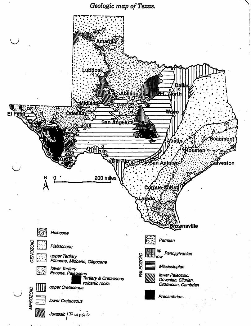
u
u
~.
~ ~ ~
S:2 U ~
~ ~
Geologic map of Texas. r: ., -;-:- 1" -;-;-:--:-:- -::-=-:t I. • • • • ••• •• ••• ., I ••••• •••• ••• • • ,. .. . . .. .. . . . . . .. .. ... .. ... .. . . • • ••••• · ....... --..."'"
N o~==-_-====-__ A
~ :j!:~i;: Holocene
[2J P/elstocefJe ..... :. ',- .
.', of,
D upper Tertiary .. PHocene,AlidCene;OHgocene . .
[lJ ~~:.~~.: lower Tertiary Eocene,
Tertiary & Cretaceous volcanic rocks am upper Cretaceous
9 loweiCr.etaceous
Jurassic l~'a.SSt ~
Permian
IlJJJJI1JIJ1I up Penn$ylvanian ~ rtffm1/ow ·0
~ ~ MIssissippian ..... ~ lower PIiI80zolc:
• • .. . .. . . . .
• o· •
• • • . .
Devonian, Silurian, Ordovician, Cambrian
Precambrian ..
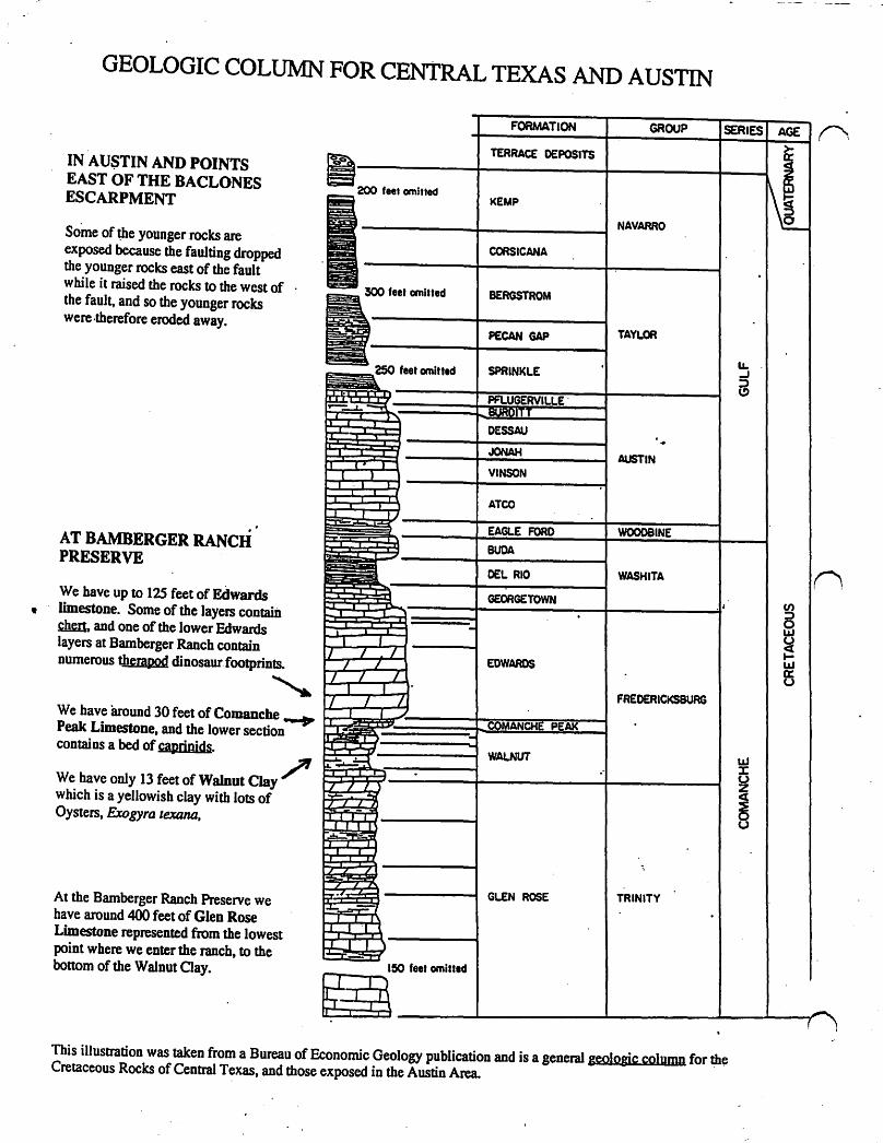
GEOLOGIC COLUMN FOR CENTRAL TEXAS AND AUSTIN
- -- GROUP I SERIES-·~_.IUN
IN AUSTIN AND POINTS EAST OF THE BACLONES ESCARPMENT
Some of Ute younger rocks are exposed because the faulting dropped the younger rocks east of the fault w bile it raised the rocks to the west of the fault, and so the younger rocks were ,therefore eroded away.
AT BAMBERGER RANCH PRESERVE
We have up to 125 feet of Edwards • limestone. Some of the layers contain ~ and one of the lower Edwards layers at Bamberger Ranch contain numerous therapod dinosaurfoolprints. , We have around 30 feet of Comanche .... Peak Limestone, and the lower section contains a bed of caprinjds.
~ We have only 13 feet of Walnut Clay which is a yellowish clay with lots of Oysters, Exogyra lexana,
At the Bamberger Ranch Preserve we have around 400 feet of Glen Rose Limestone represented from the lowest point where we enter the ranch, to the bottom of the Walnut Oay.
~ 200 feel omitted
1300 fee' emitted
250 feet omitt.d
F-~ f )
r
:J I' I ~ ) ,.
I
I .1 I I
.,. .. ~ :J -, "T 1
...,
-,- , 7 I /
7 I 7 7 L
1 1 _' 7 I 1
T f T .-"T~~ ~. ) .. -::r:::I::;[~ -r II
~..,o-9
7 / l ) ::c:' 40,;
77. Z.i. :rill -rIll .~
I
7 '7 /
7, L
;L -~J J , r
:::I J 'I 1 I:::J I )
ISO feet omitted
~
TERRACE DEPOSITS
KEMP
NAVARRO
CORSICANA
BERGSTROM
PECAN GAP TAYLOR
SPRINKLE
"' 111':1:0\111 1 II:' BURDITT
DESSAU .. . JONAH. AUSTIN
VINSON
ATCO
EAGLE FORD
DEL RIO WASHITA
~~TgWN [.
EDWARDS
FREDERICKSBURG
PEAK
WAlNUT "
;
GLEN ROSE TRINITY
This illustration was taken from a Bureau of Economic Geology publication and is a general geologic column for the Cretaceous Rocks of Central Texas, and those exposed in the Austin Area.
u. .J :;) C!)
UJ J: U Z
~
AGE n ~
~ - ,
n (I) ::::l 0 LU
~ I-LU a:: u
(
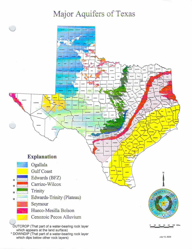
Major Aquifers of Texas
Explanation
Ogallala
Gulf Coast
* ~ Edwards (BFZ)
*~ Carrizo-Wilcox
* ~ Trinity
* r I. I Edwards-Trinity (Plateau) .. Seymour .. Hueco-Mesilla Bolson
Cenozoic Pecos Alluviwn
OUTCROP (That part of a water-bearing rock layer which appears at the land surface)
• DOWNDIP (That part of a water-bearing rock layer which dips below other rock layers)
N
t
o 20 .so 60 80 100 Miles
July 13, 2000
Minor Aquifers of Texas
Explanation Bone Spring - Victorio Peak * ~ Nacatoch
* ~ Dockum ~ Lipan
_ Brazos River Alluvium
*~ Hickory
_ West Texas Bolsons
*~. Queen City
* ' , i Woodbine
_ Igneous
_ Rita Blanca
* Ellenburger-San Saba
*~ Blossom
_ Marble Falls
Edwards-Trinity (High Plains) * ,-, Rustler
*~ Blaine
* Sparta
Capitan Reef Complex
I888l Marathon
Yegua - Jackson
OUTCROP (That part of a water-bearing rock layer which appears at the land surface) • DOWNDIP (That part of a ater-bearing rock layer which dips below other rock layers)
N
t
o 20 40 60 80 100 Mil=:! --July 16, 2001
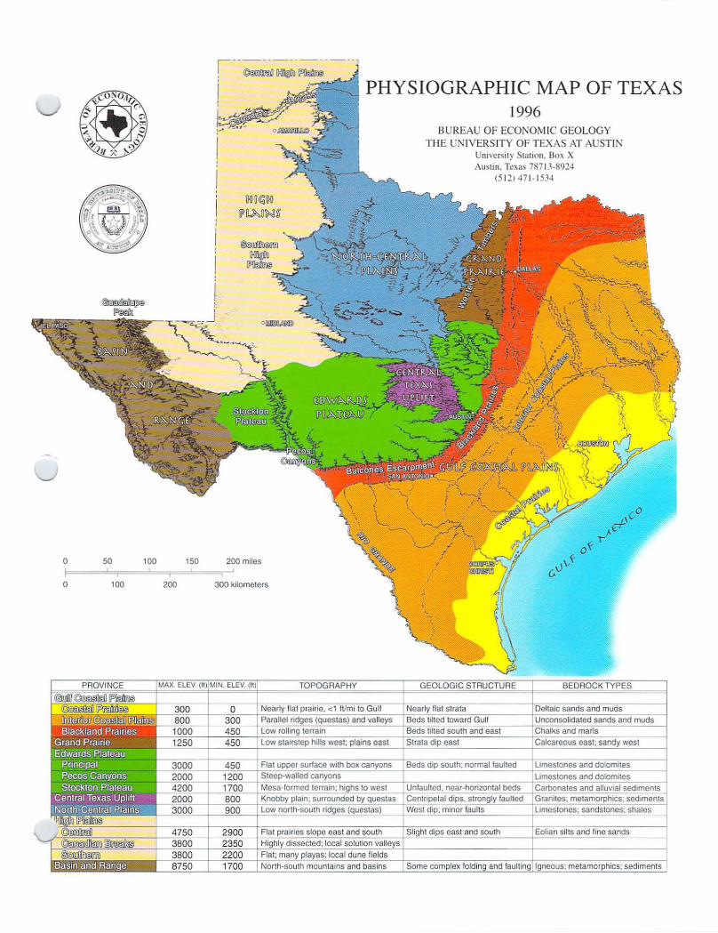
o I o
50
100
100 150
200
!---<fu>J-~-~-_----
! . -~ ...........
200 miles
300 kilometers
I .
IIi ill
; .
1 :1
PHYSIOGRAPHIC MAP OF TEXAS 1996
BUREAU OF ECONOMIC GEOLOGY TI·IE NIVERS ITY OF TEXAS AT AUSTI N
University Station. 130x X Austin. Texas 787 J 3·8924
(5 12) 471-15 34
" I i ;

Geologists study the natural scenery of Texas and sort its variations into distinctive physiographic provinces. Each province or landscape reflects a unified geological history of depositional and erosional processes. Each physiographic province is distinguished by characteristic geologic structure, rock and soil types, vegetation, and climate. The elevations and shapes of its landforms contrast significantly with those of landforms in adjacent regions. The Physiographic Map of Texas displays seven physiographic provinces and their principal subdivisions; the accompanying table describes their major physical differences. The following descriptions selectively emphasize those characteristics that distinguish provinces and their subdivisions.
Gulf Coastal Plains. The Gulf Coastal Plains include three subprovinces named the Coastal Prairies, the Interior Coastal Plains, and the Blackland Prairies. The Coastal Prairies begin at the Gulf of Mexico shoreline. Young deltaic sands, silts, and clays erode to nearly flat grasslands that form almost imperceptible slopes to the southeast. Trees are uncommon except locally along streams and in oak mottes, growing on coarser underlying sediments of ancient streams. Minor steeper slopes, from I foot to as much as 9 feet high, result from subsidence of deltaic sediments along faults. Between Corpus Christi and Brownsville, broad sand sheets pocked by low dunes and blowouts forming ponds dominate the landscape.
The Interior Coastal Plains comprise alternating belts of resistant uncemented sands among weaker shales that erode into long, sandy ridges. At least two major down-to-thecoast fault systems trend nearly parallel to the coastline. Clusters of faults also concentrate over salt domes in East Texas. That region is characterized by pine and hardwood forests and numerous permanent streams. West and south, tree density continuously declines, pines disappear in Central Texas, and chaparral brush and sparse grasses dominate between San Antonio and Laredo.
On the Blackland Prairies of the innermost Gulf Coastal Plains, chalks and marls weather to deep, black, fertile clay soils, in contrast with the thin red and tan sandy and clay soils of the Interior Gulf Coastal Plains. The blacklands have a gentle undulating surface, cleared of most natural vegetation and cultivated for crops.
From sea level at the Gulf of Mexico, the elevation of the Gulf Coastal Plains increases northward and westward. In the AustinSan Antonio area, the average elevation is about 800 feet. South of Del Rio, the western end of the Gulf Coastal Plains has an elevation of about 1,000 feet.
Grand Prairie. The eastern Grand Prairie developed on limestones; weathering and
Physiography of Texas erosion have left thin rocky soils. North and west of Fort Worth. the plateaulike surface is well exposed, and numerous streams dissect land that is mostly flat or that gently slopes southeastward. There, silver bluestem-Texas wintergrass grassland is the flora. Primarily sandstones underlie the western margin of the Grand Prairie, where post oak woods form the Western Cross Timbers.
Edwards Plateau. The Balcones Escarpment. superposed on a curved band of major normal faults, bounds the eastern and southern Edwards Plateau. Its principal area includes the Hill Country and a broad plateau. Stream erosion of the fault escarpment sculpts the Hill Country from Waco to Del Rio. The Edwards Plateau is capped by hard Cretaceous limestones. Local streams entrench the plateau as much as 1,800 feet in 15 miles. The upper drainages of streams are waterless draws that open into box canyons where springs provide permanently flowing water. Sinkholes commonly dot the limestone terrane and connect with a network of caverns. Alternating hard and soft marly limestones form a stairstep topography in the central interior of the province.
The Edwards Plateau includes the Stockton Plateau. mesal ike land that is the highest part of this subdivision. With westwarddecreasing rainfall, the vegetation grades from mesquite-juniper brush westward into creosote bush-tarbush shrubs.
The Pecos River erodes a canyon as deep as 1,000 feet between the Edwards and Stockton Plateaus. Its side streams become draws forming narrow blind canyons with nearly vertical walls. The Pecos Canyons include the major river and its side streams. Vegetation is sparse, even near springs and streams.
Central Texas Uplift. The most characteristic feature of this province is a central basin having a rolling floor studded with rounded granite hills 400 to 600 feet high. Enchanted Rock State Park is typical of this terrain. Rocks forming both basin floor and hills are among the oldest in Texas. A rim of resistant lower Paleozoic formations (see the Geology of Texas map) surrounds the basin. Beyond the Paleozoic rim is a second ridge formed of limestones like those of the Edwards Plateau. Central live oak-mesquite parks are surrounded by live oak-ashe juniper parks.
North-Central Plains. An erosional surface that developed on upper Paleozoic formations forms the North-Central Plains. Where shale bedrock prevails, meandering rivers traverse stretches of local prairie. In areas of harder bedrock, hills and rolling plains dominate. Local areas of hard sandstones and limestones cap steep slopes severely dissected near rivers. Lengthy dip slopes of strongly fractured limestones display extensive rectangular patterns. Western rocks and soils are oxidized
Bureau of Economic Geology
red or gray where gypsum dominates, whereas eastern rocks and soils weather tan to buff. Live oak-ashe juniper parks grade westward into mesquite-Iotebush brush.
Hieh Plains. The High Plains of Texas form a nearly flat plateau with an aver~ elevation approximating 3,000 feet. Extens. stream-laid sand and gravel deposits, which contain the Ogallala aquifer, underlie the plains. Windblown sands and silts form thick. rich soils and caliche locally. Havard shin oak-mesquite brush dominates the silty soils, whereas sandsage-Havard shin oak brush occupies the sand sheets. Numerous playa lakes scatter randomly over the treeless plains. The eastern boundary is a westward-retreating escarpment capped by a hard caliche. Headwaters of major rivers deeply notch the caprock, as exemplified by Palo Duro Canyon and Caprock Canyons State Parks.
On the High Plains, widespread small. intermittent streams dominate the drainage. The Canadian River cuts across the province, creating the Canadian Breaks and separating the Central High Plains from the Southern High Plains. Pecos River drainage erodes the west-facing escarpment of the Southern High Plains, which terminates against the Edwards Plateau on the south.
Basin and Ranee. The Basin and Range province contains eight mountain peaks that are higher than 8,000 feet At 8,749 feet, Guadalupe Peak is the highest point in Texas. Mountain ranges generally trend nearly north-south and rise abruptly from barren rocky plains.
Plateaus in which the rocks are nea~ horizontal and less deformed commonly fll , the mountains. Cores of strongly folded anu faulted sedimentary and volcanic rocks or of granite rocks compose the interiors of mountain ranges. Volcanic rocks form many peaks. Large flows of volcanic ash and thick deposits of volcanic debris flank the slopes of most former volcanoes. Ancient volcanic activity of the Texas Basin and Range province was mostly explosive in nature, like Mount Saint Helens. Volcanoes that poured successive lava flows are uncommon. Eroded craters, where the cores of volcanoes collapsed and subsided, are abundant.
Gray oak-pinyon pine-alligator juniper parks drape the highest elevations. Creosote bush and lechuguilla shrubs sparsely populate plateaus and intermediate elevations. Tobosablack grama grassland occupies the low basins.
The Physiographic Map of Texas is a useful guide to appreciate statewide travel. Texas abounds with vistas of mountains, plateaus, plains, hills, and valleys in which many rock types and geologic structures are exposed. A variety of vegetation grows, depending on local climate.
-Text by E. G. Wermund
The Bureau of Economic Geology, established in 1909, is a research entity of The University of Texas at Austin and also functions as the State Geological Survey. The Bureau conducts basic and applied research projects in energy and mineral resources, coastal and environmental studies, land resources, and geologic mapping. Reports and maps published by the Bureau are available for a nominal price. A list of publications is available on request.
The University of Texas at Austin • University Station, Box X • Austin, Texas 78713-8924 • (512) 471-1534 Web: http://www.utexas.edulresearchlbeg! • Publication Sales: (512) 471-7144, 1-888-839-4365 (toll-free USA)
c) c
m§i -.--------------I~O ,,!'LES
llANO ~IVER VALLEY
Sprl~
I EDWARDS PLATEAU AQUIFER
fiGURE 6:
. RELATIVE POSITION Of KERRVILLE & fREDERICKSBURG
RELATIVE POSITION Of AUSTIN & SAN ANTONIO
, I
.ij 6 RELATIVE POSITIONS Of
COMAL, AQUARENA & BARTON SPRINGS
AI_ .tr .... fl_in8 ij eo,twa,eI .. lOu.hwof4 011 EeI .. _ PIo ...
~ .1 .... ~-~-~,
.. r., ...... eOltwo,d & .,.he •• "" ,"'" ," Ed ... ,.,..Z-
Aquile,.
8ALCONES fAULT ZONE
IECHAIGE I ARTESIAN ZONE ZONE .
GlEN "atl' lAD 'M. WATERUNE
c
SCHEMADC CROSS SECTION SHOWING RELATIONS OF THE EOWARDS AQUifERS,
CENTRAL TEXAS HILL COUNTRY DRAINAGE AREA
EDWARDS FAULT-ZONE AQUIFER
GULf COASTAL PLAIN
mll~IOSf AUGUST. 19M
c .. 1
c.
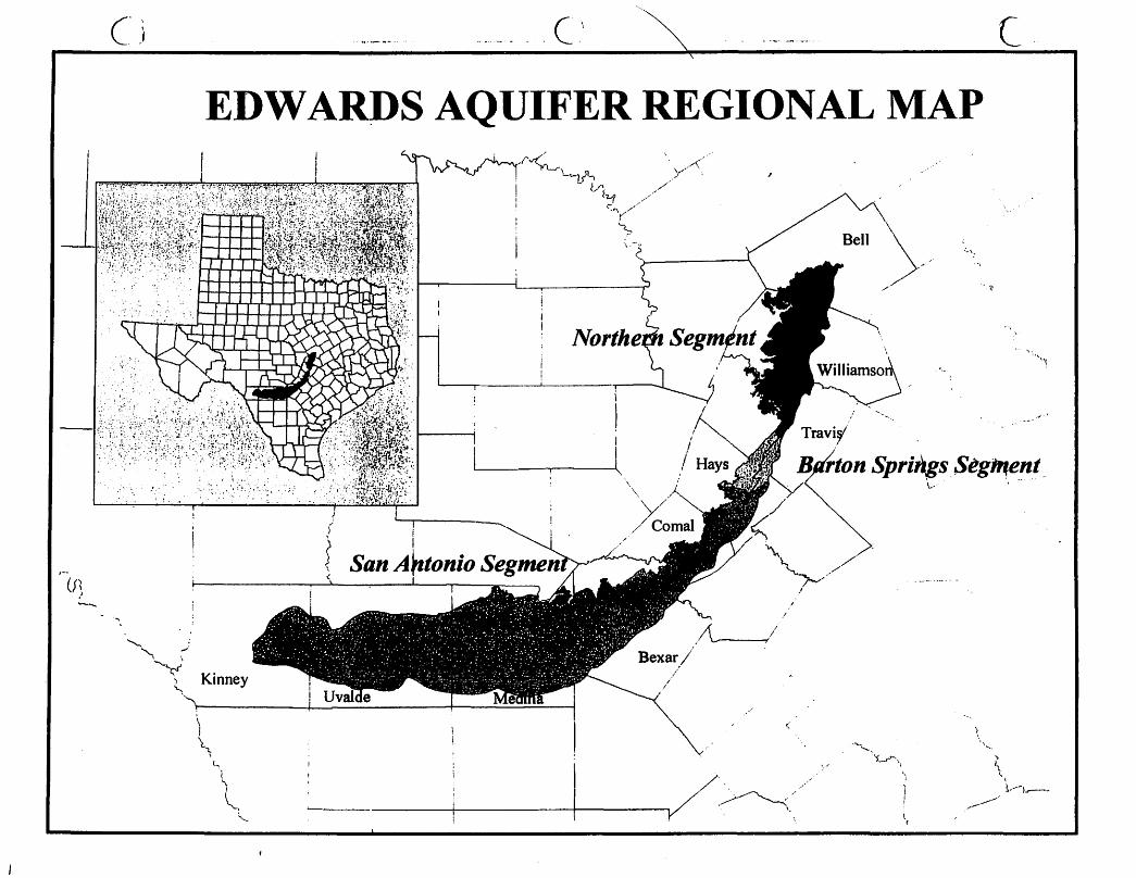
I-(f~
---....
c· j
'..,
'" ,.,' "-; \
Y
. (\ c EDWARDS AQUIFER REGIONAL MAP
I
I \
San AntonIo
Kinney
t \
~(
l, '-
" \.
v ...... -< /
././'
.'/
"
<;"
/~:
:"';
'·tJ
~'\.·I
Travi~/
Kn.-tnn Spri.;,gs.Seg".ent~ .\.... ' •.....
..... ----'.'l.....r.-\
\ \'"
" 1\
\
_/' .. --1 .. --1..----
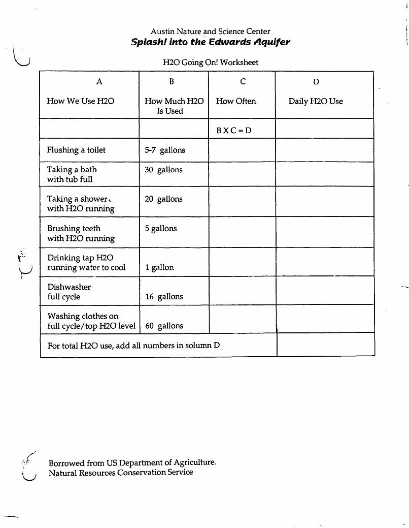
.. ~
·U
--
A
Austin Nature and Science Center .Splash! into the Edwards 74.quifer
H20 Going On! Worksheet
B C D
How We Use H2O How Much H2O How Often Daily H2O Use Is Used
BXC=D
Flushing a toilet 5-7 gallons
Taking a bath 30 gallons with tub full
Taking a shower, 20 gallons with H20 running
Brushing teeth 5 gallons with H20 running
Drinking tap H2O running water to cool 1 gallon
Dishwasher full cycle 16 gallons
Washing clothes on full cycle / top H2O level 60 gallons
For total H20 use, add all numbers in solumn D
Borrowed from US Department of Agriculture. Natural Resources Conservation Service
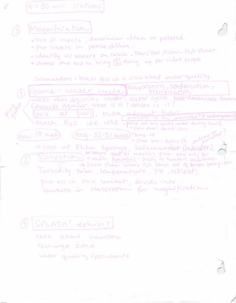
•
f l
~I (
!
r
/