Embed Size (px)
Citation preview
Augmented reality used in navigation.
Project 2
Theme: improvement and innovation
Netherlands Maritime University Lloydstraat 300
3024EA Rotterdam Netherlands
Date: 5 februari 2013 Group 8, LZHBOM3C Version: 1.5 Group members: Arthur de Vlaming Nr: 0850014, Email: [email protected] Rick Verhoef Nr: 0847319, Email: [email protected] Erin Meijer Nr: 0855479, Email: [email protected] Maarten Kuipers Nr: 0852006, Email: [email protected] Group managers: Mr. G. Blankenstein Email: [email protected] Mr. P.C. van Kluijven Email: [email protected]
2
Content • 1 Preface page: 3 • 2 Introduction page: 3
o 2.1 Problem description o 2.2 Problem definition o 2.3 Main question o 2.4 Sub questions o 2.5 Project borders o 2.6 Research methodology o 2.7 Project objective
• 3 The definition of Augmented reality page: 6 o 3.1 Augmented reality o 3.2 Visualization
3.2.1 Optical combination 3.2.2 Visual combination
o 3.3 Registration o 3.4 Tracking o 3.5 Sensors
• 4 Augmented reality used today page: 8 o 4.1 Heads up display
4.1.1 Definitions of heads up display 4.1.2 Generations of HUDs 4.1.3 Applications of HUDs
o 4.2 Head mounted display • 5 Information needed for maritime navigation page: 10
o 5.1 Primary information 5.1.1 Own vessel information 5.1.2 Buoys and shipping lanes 5.1.3 COLREGS
o 5.2 Secondary Information 5.2.1 shallow waters, underwater obstacles, wrecks 5.2.2 Information on other vessels
o 5.3 During restricted visibility o 5.4 Alert priorities according to IMO standards
• 6 The effect of augmented reality on safety page: 13 o 6.1 Introduction o 6.2 Application for safety
6.2.1 Current situation 6.2.2 Situation with AR technology 6.2.3 Improvement in safety
• 7 The effect of augmented reality on situational awareness page: 15 o 7.1 Introduction o 7.2 Applications for situational awareness
• 8 Conclusions page: 17 • 9 Recommendations page: 18 • 10 List of abbreviations page: 19 • 11 References page: 20
o 11.1 Online references o 11.2 Literary references o 11.3 Other sources
• Appendix A: Summarized interviews
3
1 Preface This report is written as part of the main phase project. In this report the project group will elaborate on the research that is carried out and the conclusions derived from this research. The topic of this report is Augmented Reality. We would like to thank Mr. Griffioen for his assistance with the radar simulator.
2 Introduction 2.1 Problem description The topic Augmented reality used in navigation was chosen because it is a very interesting topic, but also very innovative. Similar systems have been used in airplanes and military applications, but never in maritime navigation. In maritime navigation an officer is exposed to a lot of information. This information is displayed on different screens and monitors. To read this information the officer has to turn his or her attention away from the view outside the bridge (This will now be called: head down posture/ head down time). If all the information is displayed in a heads-up display or by Augmented reality glasses the officer can keep his or her attention on the outside view, and have all the information there in one screen. This will reduce the head down time and improve safety. In this project the goal of the research is to find out how Augmented reality can improve the safety and situation awareness. 2.2 Problem definition The problem is that there are a lot of systems on the bridge that the officer needs to keep track of. While viewing the necessary information from the various systems the officer cannot keep a proper look out.
4
2.3 Definition of the main question In this project augmented reality is used on the bridge of a vessel. It will be integrated with the normal navigation systems. This information is projected on the windows and special glasses. The information shown on the windows will not block the view from outside but add information. By showing this information all in one screen and on the window it will reduce the head down time of the officer of the watch. It is expected that this will increase the safety on board and the situational awareness. This system is not used in maritime navigation but it exists in other applications. It’s a completely new way of using this technology. Main Question: How can Augmented reality improve maritime navigation?
2.4 Definition of the sub questions What is Augmented reality? -explaining the system and our vision. How is Augmented reality used today? -Applications in other sections of navigation. What information is needed for maritime navigation? -Ideas of the project group. -Input from experienced seafarers. How will the information be shown on the screens? -Will all the information be on one screen? -Switching between different views. How Will Augmented reality improve safety? -Shipping lane information during low visibility. -Shallow water shown. How Will Augmented reality improve situational awareness? -All vessels information shown. -All information in one system.
5
2.5 Project borders To avoid mistakes between the principal and the project group, the borders of this project will be clearly defined. The project will contain: Researching if it is possible to use augmented reality for navigation on sea, and how to best project the live view to the officer of the watch. What will augmented reality mean for the safety on board and which systems will be connected with the augmented reality system. An artist impression will be made showing what the augmented reality will look like. The project group will look at the possibilities and limitations regarding the technical aspects. The project will not include: The building of the actual software. There will be no investigation of the legal aspects of the system. The start of the project was on Thursday 6 September 2012. 2.6 Research methodology In this project two types of primary research were used: qualitative research and quantitative research. As a precursor to primary research desk research was carried out. Desk research was used to find what augmented reality is. It is determined how augmented reality is used today and what the possibilities and limitations of AR systems are. In the field research both qualitative and quantitative research was carried out to determine how seafarers think about the system and what information is on the screen. This was carried out in the form of a questionnaire, which is quantitative, to obtain statistical data and then backed it up with an interview which is a qualitative research. An experiment using a beamer to create an impression of the AR system is also used to determine its usefulness and to help design the layout. 2.7 Project objective The goal of this project is to reduce the head down time and thus creating more time to look outside. This to improve the situational awareness of the OOW and improve the safety. The objective of this project is to determine if the AR system is technically feasible and to determine if it will improve safety and situational awareness.
6
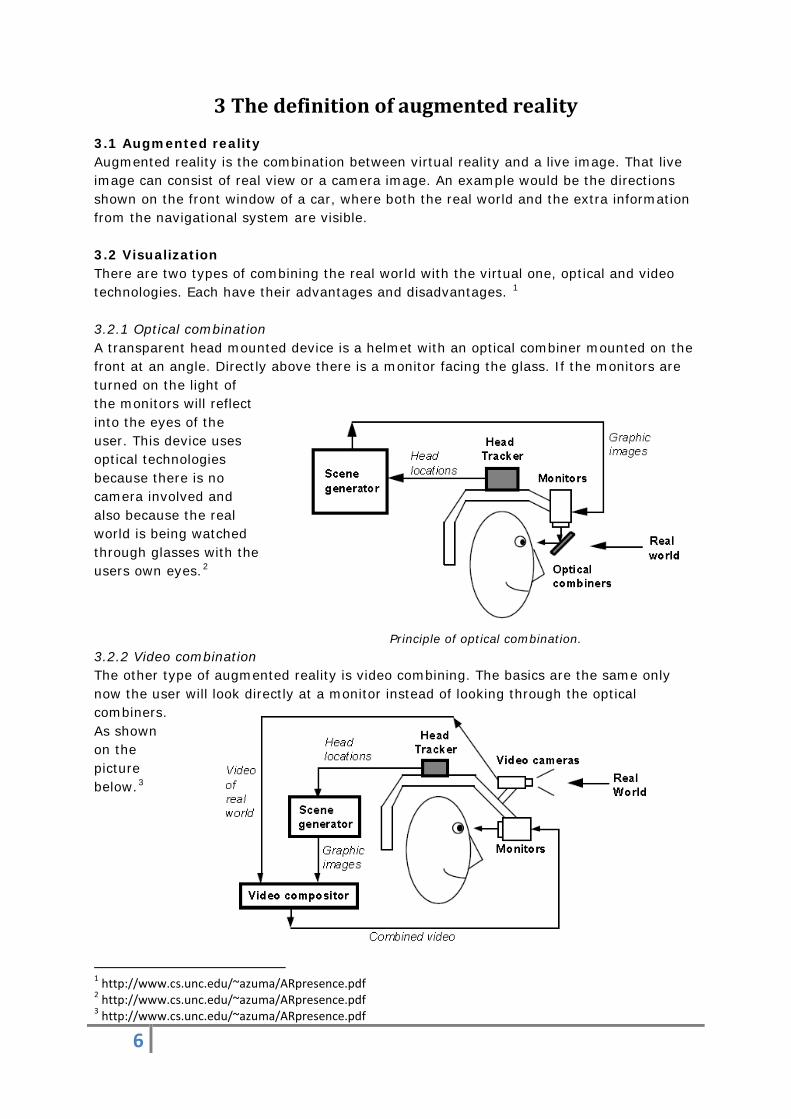
3 The definition of augmented reality 3.1 Augmented reality Augmented reality is the combination between virtual reality and a live image. That live image can consist of real view or a camera image. An example would be the directions shown on the front window of a car, where both the real world and the extra information from the navigational system are visible. 3.2 Visualization There are two types of combining the real world with the virtual one, optical and video technologies. Each have their advantages and disadvantages. 1 3.2.1 Optical combination A transparent head mounted device is a helmet with an optical combiner mounted on the front at an angle. Directly above there is a monitor facing the glass. If the monitors are turned on the light of the monitors will reflect into the eyes of the user. This device uses optical technologies because there is no camera involved and also because the real world is being watched through glasses with the users own eyes.2
Principle of optical combination. 3.2.2 Video combination The other type of augmented reality is video combining. The basics are the same only now the user will look directly at a monitor instead of looking through the optical combiners. As shown on the picture below.3
1 http://www.cs.unc.edu/~azuma/ARpresence.pdf 2 http://www.cs.unc.edu/~azuma/ARpresence.pdf 3 http://www.cs.unc.edu/~azuma/ARpresence.pdf
7
3.3 Registration Registration is the accurate alignment of virtual and real images. When a user remains motionless and can see a perfect alignment of the real and virtual images then the system has a good static registration. However AR systems should also have a good dynamic registration meaning that when the user is moving there should be no lag or jitter between real and virtual objects. Many variables are needed to take into consideration, depending on the type of display used, but a crucial component in every system is a continuous knowledge of the user’s viewpoint in order to render virtual graphics from the correct position.4
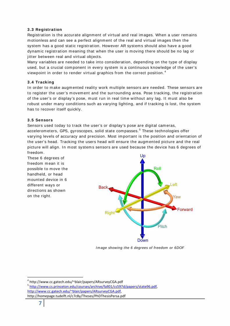
3.4 Tracking In order to make augmented reality work multiple sensors are needed. These sensors are to register the user’s movement and the surrounding area. Pose tracking, the registration of the user’s or display’s pose, must run in real time without any lag. It must also be robust under many conditions such as varying lighting, and if tracking is lost, the system has to recover itself quickly. 3.5 Sensors Sensors used today to track the user’s or display’s pose are digital cameras, accelerometers, GPS, gyroscopes, solid state compasses.5 These technologies offer varying levels of accuracy and precision. Most important is the position and orientation of the user's head. Tracking the users head will ensure the augmented picture and the real picture will align. In most systems sensors are used because the device has 6 degrees of freedom. These 6 degrees of freedom mean it is possible to move the handheld, or head mounted device in 6 different ways or directions as shown on the right.
Image showing the 6 degrees of freedom or 6DOF
4 http://www.cc.gatech.edu/~blair/papers/ARsurveyCGA.pdf 5 http://www.cs.princeton.edu/courses/archive/fall01/cs597d/papers/state96.pdf, http://www.cc.gatech.edu/~blair/papers/ARsurveyCGA.pdf, http://homepage.tudelft.nl/c7c8y/Theses/PhDThesisPersa.pdf
8
4 Augmented reality used today
Today augmented reality has multiple applications and is used in aviation, the military, in cars but it is also used by surgeons and engineers and for recreational purposes. 6
4.1 Heads up display 4.1.1 Definition of heads up display A Heads up display or HUD is a transparent display that presents data without requiring users to look away from their usual viewpoints. The heads-up display was initially developed for the military but is now also used in commercial aircrafts and cars. In its most simplistic form a heads up display is a semi see-through mirror showing the image that is projected onto it and the real view on the other side of the mirror. These mirrors usually consist of a piece of glass with a special coating that reflects the monochromatic light projected onto it from the projector unit while allowing all other wavelengths of light to pass through.
4.1.2 Different generations of HUDs There are several technologies for heads up displays divided into four generations
The first generation uses a CRT screen to generate the image on the semi see-through screen, this screen is coated with phosphor which has the disadvantage that it degrades over time.
The second generation uses an LCD screen with a solid state light source, the light source is modulated by the LCD screen to display an image.
The third generation uses optical waveguides to produce an image directly in the combiner instead of using a projector system.
The fourth generation uses a scanning laser to display images on a transparent medium.7
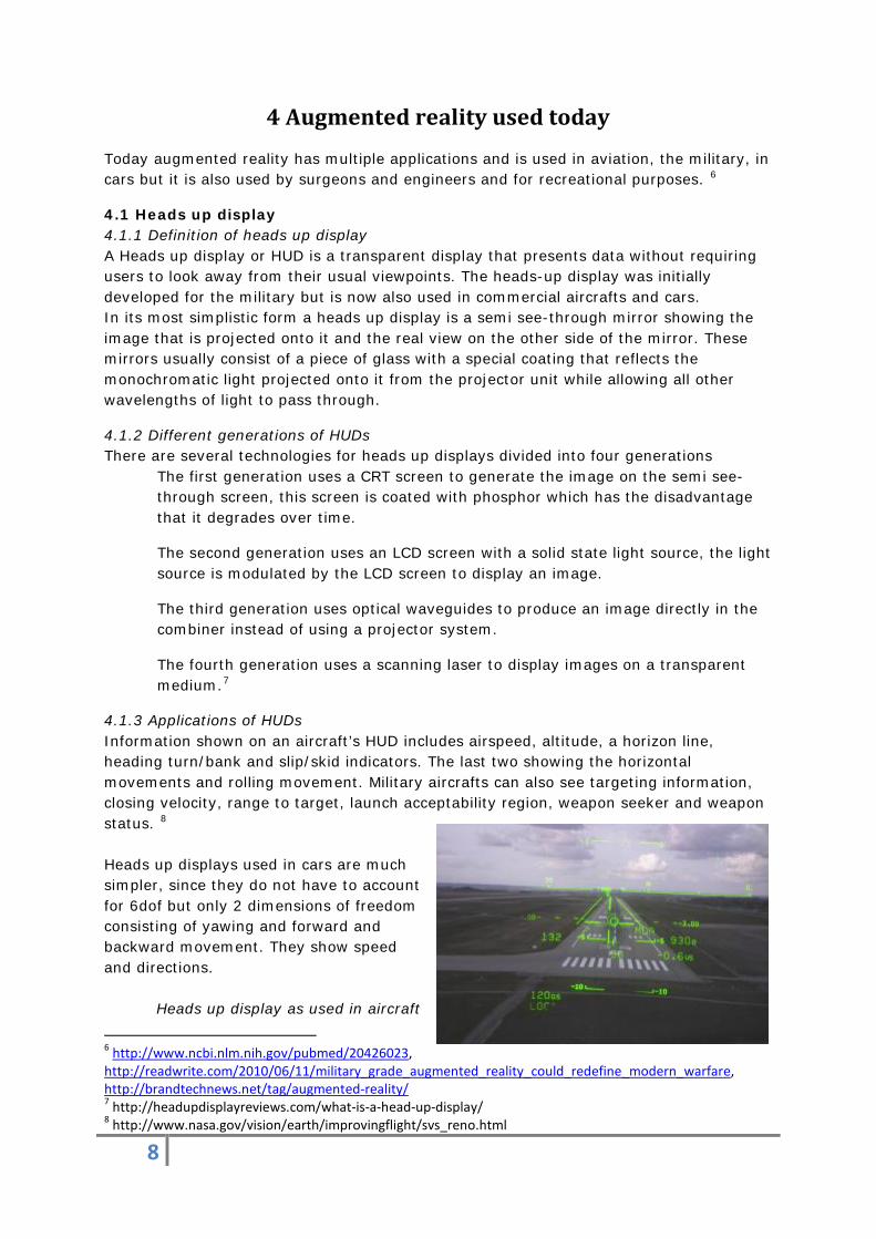
4.1.3 Applications of HUDs Information shown on an aircraft’s HUD includes airspeed, altitude, a horizon line, heading turn/bank and slip/skid indicators. The last two showing the horizontal movements and rolling movement. Military aircrafts can also see targeting information, closing velocity, range to target, launch acceptability region, weapon seeker and weapon status. 8 Heads up displays used in cars are much simpler, since they do not have to account for 6dof but only 2 dimensions of freedom consisting of yawing and forward and backward movement. They show speed and directions.
Heads up display as used in aircraft
6 http://www.ncbi.nlm.nih.gov/pubmed/20426023, http://readwrite.com/2010/06/11/military_grade_augmented_reality_could_redefine_modern_warfare, http://brandtechnews.net/tag/augmented-reality/ 7 http://headupdisplayreviews.com/what-is-a-head-up-display/ 8 http://www.nasa.gov/vision/earth/improvingflight/svs_reno.html
9
4.2 Head mounted display Head mounted displays or HMDs are used in a wide field of applications, it is used in aviation and military but it is also used by engineers and surgeons to see a layered view of a person or a piece of machinery.9 Head mounted displays can also be used for recreational activities. A head mounted display can be worn as a helmet or as goggles/glasses. It is in many ways similar to a heads up display. Only a HUD is fixed and HMD is a device worn by a user so it can be more freely used e.g.: pointed in multiple directions.
Engineers use head mounted displays to provide a 3D view of schematics of complex systems. This is useful because the engineer can see a layered view of the system, meaning he knows what is behind for example an iron cover before removing it. A similar version of this technique is used in surgery where the real view of the surgeon is combined with CAT scans and MRI imaging.
Head mounted displays in military aircrafts show all the information a HUD shows but does not require the pilot to look through the HUD. The advantage of this is that the pilot can look at an aircraft flying above him and immediately knows its speed, altitude and other useful information.
9 http://www.ncbi.nlm.nih.gov/pubmed/20426023
10
5 Information needed for maritime navigation
The bridge of a vessel contains large amounts of information that is needed for safe navigation. All this information will be integrated in the augmented reality system. The proposed system will use a static HUD. This means that the information is only visible from one position. This is to maintain a proper alignment of the AR system and the real world. In order to optimize the presentation of the information in the AR system this needs to be divided between primary and secondary information. Primary information will be the information that is always shown on the screen, secondary information will be a second layer that can be applied in busy areas. Special information can also be selected using the controls of the AR system. All these options will be controlled by smart menus. These menus consist of selected layouts with certain combinations of data that are useful in specific situations. Such as a smart menu geared towards sailing in low visibility or when navigating in restricted waters. These menus can be personalized by the officers. The AR system relies on the input of the other navigational equipment. When this input is not correct then the AR system will not be able to produce a correct augmented reality view. 5.1 Primary information There are several systems that will be integrated as primary information. Several interviews with experienced seafarers were held to find out what they believe is primary or secondary information needed for safe navigation. 10 5.1.1 Own vessel information On the main screen the ground track and the vessel’s own speed will be shown. This is core information for safe navigation. When the officer does not know where the vessel is going at what speed he cannot navigate safely. The ground track will be shown on the screen as a coloured line or path with the true direction shown in degrees. Using information from the radar a vector corrected for wind and stream can also be shown. The speed will also be shown on this line in nautical miles per hour (knots). The system can also give a warning when the vessel is moving out of the planned track. This track consists out of the waypoint the OOW puts in the ECDIS during voyage planning. 5.1.2 Buoys and shipping lanes Buoyage systems and shipping lanes will also be integrated as primary information. This means that the system is always on, but this does not mean it always shows something on the screen. The reason for this is simple because in ocean passages there are no buoying systems or shipping lanes, but as soon as the vessel enters one it will be shown on the screen. Buoys will be shown by their top mark, this makes them easy to identify. Shipping lanes will be shown by a coloured line. Shipping lanes are usually marked by buoys as well and could also be recognized in the same way as buoys normally would. 10 Summaries of the interviews can be found in appendix A
11
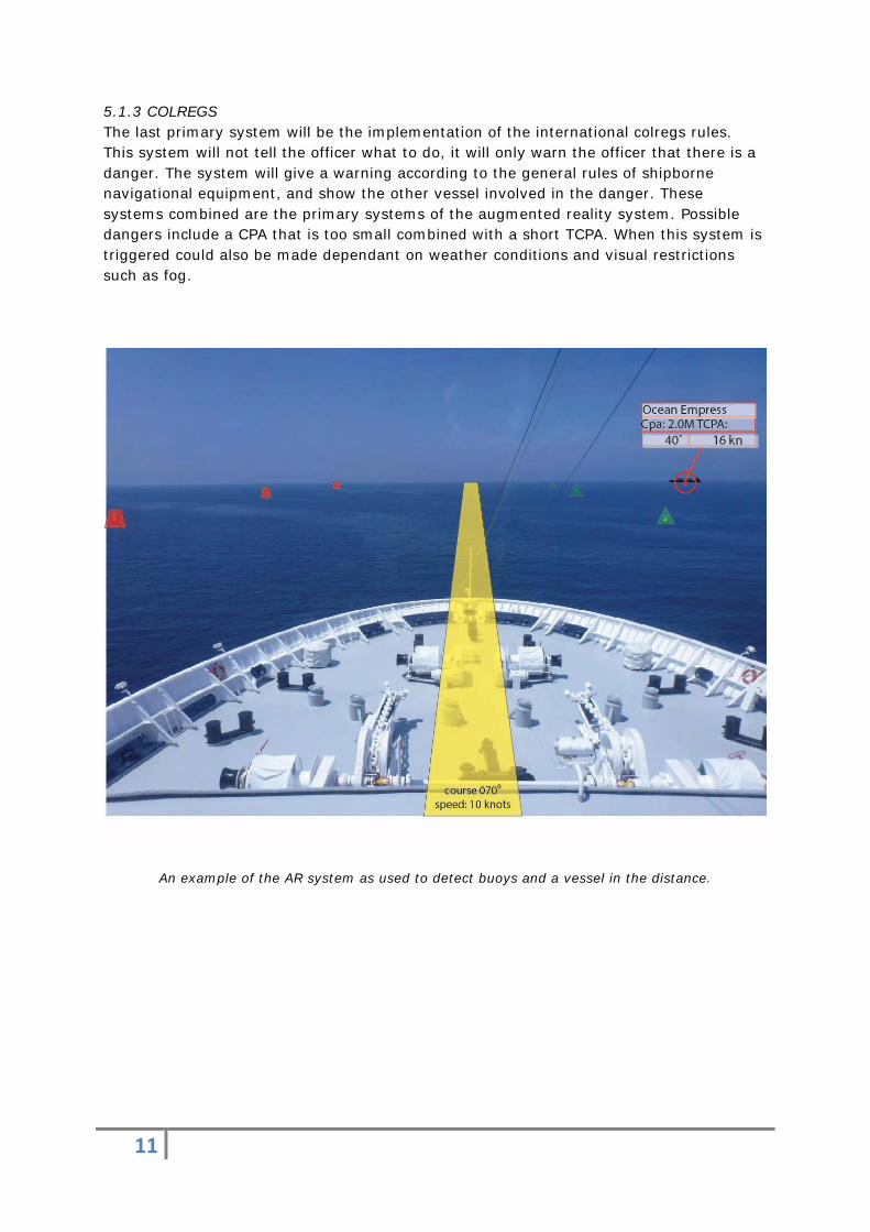
5.1.3 COLREGS The last primary system will be the implementation of the international colregs rules. This system will not tell the officer what to do, it will only warn the officer that there is a danger. The system will give a warning according to the general rules of shipborne navigational equipment, and show the other vessel involved in the danger. These systems combined are the primary systems of the augmented reality system. Possible dangers include a CPA that is too small combined with a short TCPA. When this system is triggered could also be made dependant on weather conditions and visual restrictions such as fog.
An example of the AR system as used to detect buoys and a vessel in the distance.
12
5.2 Secondary information Secondary information is information that is not always shown but will be available to the OOW when he decides so. This information is less critical to the safety and more geared towards improving the general awareness. When a danger may occur that is determined by secondary information the OOW will still be immediately warned. 5.2.1 Shallow waters, underwater obstacles, wrecks When the vessel comes close to water of insufficient depth or any underwater obstacles the system will warn the OOW of said danger(example: wreck) and indicate it on the main screen. This will mainly happen when the vessel moves out of the planned track. All data required for correct positioning of these objects is obtained from the ECDIS. This means it is important that the ECDIS information is up to date. 5.2.2 Information on other vessels The system will also show other vessels by combining the radar and the AIS. Information that the system will show include the name of the other vessel, its course and speed and its CPA and TCPA. More information on other vessels can also be obtained and presented if required by the OOW. This includes call sign and MMSI number. By combining radar and AIS input the largest possible amount of vessels and other objects in the vicinity of the own ship can be detected. 5.3 During restricted visibility During restricted visibility the OOW may require more information than during normal situations. The AR system can be of assistance in this by indicating other vessels that would not be visible with the naked eye. During fog or otherwise restricted visibility it is also possible that aids to navigation such as sector lights, lights in line and buoys are not visible. Using the information from the ECDIS and GPS the AR system would be able to display such lights in the position they would normally be seen in. 5.4 Alert priorities according to the IMO standards When the system detects that there is a possible danger alerts should be given according to the IMO Standards. Paraphrased to fit to the AR system these are as follows:11 An alarm should indicate conditions requiring immediate attention and action from bridge personnel. A warning should indicate changed conditions and should be presented for precautionary reasons only. These conditions are not immediately hazardous, but could become so if no action is taken. A caution should indicate a condition which does not warrant an alarm or warning but should still be taken into account when considering the situation. The AR system can indicate various dangers and they should be displayed when there is need for immediate action.
11 Performance standards for shipborne radio Communications and navigational equipment
13
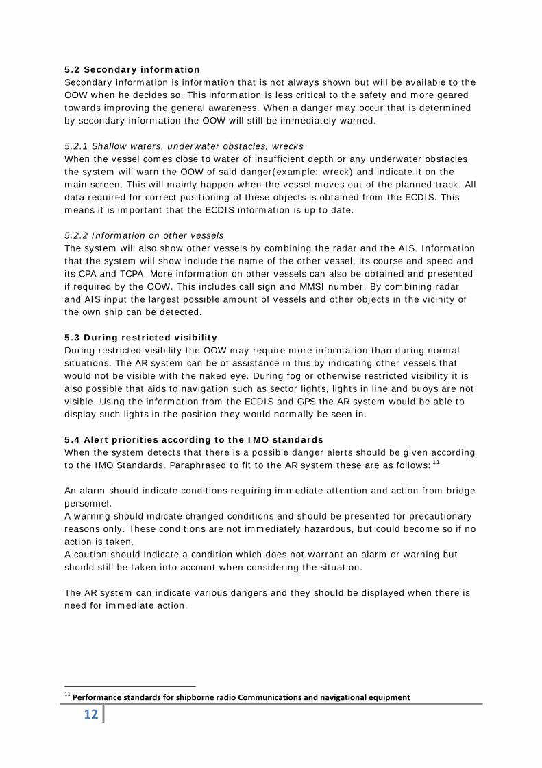
6 The effect of augmented reality on safety 6.1 Introduction There are a lot of systems that give information to the augmented reality system. The augmented reality system combines all this information and so there is a lot of useful complementing information. How all this information will be shown, what the system is and what information is needed is discussed in the sub questions before. To navigate safely the augmented reality system needs a lot of information. When all this information has been processed by the system, the result will be a certain augmented reality view. The system can give warnings when a potentially dangerous situation is developing. For example: The AR system knows the draft of the vessel and when the vessel is heading to water of insufficient depth the AR system can give a warning and show this on the AR view. There are many more situations where the AR system can give warnings when danger is expected if it has the available information. There are a lot of different ways to show the information of the AR system, the best way to show this information is in smart menus. This is discussed in a sub question above. How the system shows the information and in what kind of situation, will determine if and how the safety of navigation will improve.
Simulation of the AR system, created using the radar simulator at the STC. Buoys that would not be visible to the naked eye due to fog can still be seen using the AR system.
14
6.2 Application for safety 6.2.1 Current situation. At the moment the officer of the watch has to look on different screens for the information to navigate safely. These screens are integrated in the bridge console. In order to look at these screens the officer has to put his head down also known as the ‘head down time’. During this time the officer of the watch is unable to look at his surroundings.12 6.2.2 Situation with AR technology The information of the AR system will be shown on a heads up display integrated in the windows of the bridge. At this point the officer of the watch does not have to put his head down to read the information. The officer of the watch also does not have to look on different screens, because all the crucial information is presented in a single display. The officer of the watch can also look outside, where the AR system will show the information the officer wants to see it. This information will match with the real view outside of the window. In this way the officer does not have to translate the information of the charts and other displayed information to the real outside view, because the AR system is doing this for the officer. This will not only reduce the head down time of the officer but also improve the awareness of the situation.13 6.2.3 Improvement in safety The information in the system will be shown as described in the previous chapters. This will improve safety because of the fact that the information is shown more clearly and more complete to the officer. The system can warn the officer when the vessel runs into any potential dangers. By showing primary information the officer will have fewer distractions, improving safety.
12 http://www.niqld.net/resources/bridge_instrument_orientation.pdf 13 http://pages.nxtbook.com/nxtbooks/questex/gps0612/offline/questex_gps0612.pdf Page 47
15
7 The effect of augmented reality on situational awareness
7.1 Introduction To see if situational awareness is improved by the AR system it is necessary to look at some of the questions answered earlier. These are:
• How will the real time information be presented in the AR system • Which information will be presented in the AR system • Is it possible to show information that is needed for a special kind of situation • And if this is possible, will the system then recognize this situation and give the
necessary information that the officer of the watch will need to properly react to the circumstances
• What is the information in the AR system These are all aspects of the system that needed to be researched before it can be determined if the AR system will improve situational awareness and how this will be done. These questions have been researched in the sub questions before and the conclusions will be used in applications for safety and situational awareness. 7.2 Applications for situational awareness An advantage of the AR system is that all the information is there in one system in front of the officer. This system is situated on a head up display in the windows of the bridge.14 But will this also improve the situational awareness? When the vessel is in a situation with bad weather and low visibility, nowadays the officer of the watch has to use the radar and AIS to look around the vessel to see what other vessels are doing. With the AR system the officer can look outside the window and put the information of the radar and AIS on the head up display and directly get the information of the vessels around him. In this way the officer can see where the other vessels are and what their speeds and courses are. The place that the vessel is shown on the head up display correlates with the real position of the vessel in good visibility. This way it is easier and more natural for the officer of the watch to decide if there is a dangerous situation around his vessel. In this way augmented reality improves situational awareness.15 Another situation would be when there is a barely visible vessel close to the vessel with the AR system. And that vessel is not on the radar and does not have AIS. Then the vessel will not be made visible by the AR system. But because the AR system is located on a head up display in the window of the bridge the officer of the watch is also looking outside. Today the officer is looking down on his radar screen and cannot look out of the window all the time. When equipped with the AR system the officer is aware of his surroundings, so there is a better chance that the officer will actually see the inconspicuous vessel in time.
14 http://www.niqld.net/resources/bridge_instrument_orientation.pdf 15 http://www.anacapasciences.com/projects/hud/Holder-EH-01-Maritime%20HUD%20Preliminary%20Evaluation.pdf
16
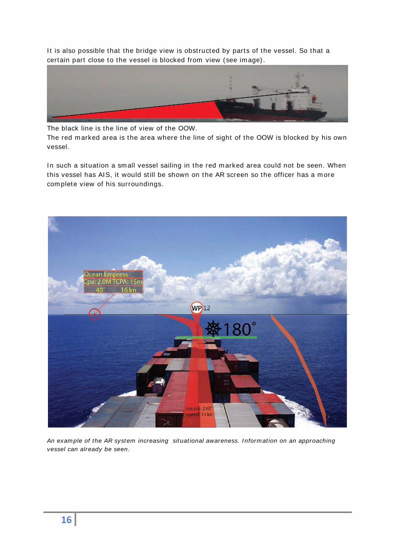
It is also possible that the bridge view is obstructed by parts of the vessel. So that a certain part close to the vessel is blocked from view (see image).
The black line is the line of view of the OOW. The red marked area is the area where the line of sight of the OOW is blocked by his own vessel. In such a situation a small vessel sailing in the red marked area could not be seen. When this vessel has AIS, it would still be shown on the AR screen so the officer has a more complete view of his surroundings.
An example of the AR system increasing situational awareness. Information on an approaching vessel can already be seen.
17
8. Conclusions The augmented reality system will improve the maritime navigation in multiple aspects regarding the safety and situational awareness. With the AR system the OOW does not have to look on multiple screens and can look outside while reading the data needed for navigation, this will improve situational awareness. The proposed system will use a static HUD. This is to maintain a proper alignment of the AR system and the real world. The safety will be improved because of an increase in situational awareness. This is achieved by the inclusion of multiple systems in the AR system such as ECDIS and radar which can identify potential hazards. The system can also automatically generate and show on screen alarms and warnings in dangerous situations.
One of the most important aspects of the system is that it is necessary that the AR view should align with the real view outside. If this is achieved the system can be used reliably.
Although the system is able to improve safety by increasing the situational awareness normal restrictions still apply. The AR system relies on the input of the other navigational equipment. When this input is incorrect then the AR system will be unable to produce a correct augmented reality.
The augmented reality system envisioned could be made with today’s technology and is therefore technically feasible.
Usage of Augmented Reality technology in navigation also seems to be considered by the industry as seen in a new bridge generation being developed.16 17
16 http://www.ulsteinlab.com/ 17 http://www.pole-mer-bretagne.com/sigran_0.php
18
9 Recommendations In order realize the AR system it is recommended to research the best way to integrate the various bridge systems. This means that it will be necessary to integrate the input from the radar, AIS, ECDIS etcetera. The combined information is necessary for the system to function correctly.
Software needs to be written that can interpret and organize the input from the navigational equipment into a correct augmented reality view.
Research needs to be done in the correct way of presenting information on a HUD. Taking into account the effect certain colors and shapes have on how such information is perceived by the human mind.
19
10 List of Abbreviations The following is a list of abbreviations used in this report in alphabetical order.
6DOF: 6 Degrees Of Freedom AIS: Automatic Identification System AR: Augmented Reality CPA: Closest Point of Approach COLREGS: Collision Regulations ECDIS: Electronic Chart Display Information System HUD: Heads Up Display IMO: International Maritime Organization TCPA: Time to CPA MMSI: Maritime Mobile Service Identity OOW: Officer of the Watch
20
11 References 11.1 Online references
1. http://www.ausairpower.net/TE-Fighter-Cockpits.html 2. http://www.cs.unc.edu/~azuma/ARpresence.pdf 3. http://studierstube.icg.tugraz.at/thesis/Wagner_PhDthesis_final.pdf 4. http://www.ronaldazuma.com/papers/cga99.pdf 5. http://homepage.tudelft.nl/c7c8y/Theses/PhDThesisPersa.pdf 6. http://archsurg.jamanetwork.com/article.aspx?articleid=396410 7. http://reference.kfupm.edu.sa/content/a/u/augmented_reality_visualization_for_l
apa_55615.pdf 8. hrcak.srce.hr/file/106490 9. http://www.technologyreview.com/news/415977/faster-maintenance-with-
augmented-reality/ 10. http://www.anacapasciences.com/projects/hud/Holder-EH-01-
Maritime%20HUD%20Preliminary%20Evaluation.pdf 11. http://www.niqld.net/resources/bridge_instrument_orientation.pdf 12. http://www.mikesflightdeck.com/hud/head_up_displays.html 13. http://www.rockwellcollins.com/Products_and_Systems/Displays/Head_up_Displa
ys.aspx 14. http://www.elbitsystems.com/elbitmain/area-
in2.asp?parent=18&num=139&num2=139 15. http://www.hhcc.com/blog/wp-content/uploads/2009/12/window3.jpg 16. http://justinsomnia.org/images/cap-cleveland-bridge-view-raining-cloud-big.jpg 17. http://pages.nxtbook.com/nxtbooks/questex/gps0612/offline/questex_gps0612.p
df 18. http://www.ulsteinlab.com/ 19. http://www.pole-mer-bretagne.com/sigran_0.php
11.2 Literary references
• Performance standards for Shipborne Radio Communications and Navigational Equipment, edition 2008, IMO
11.3 Other sources
• Interviews with several experienced seafarers. (Summaries in appendix A.) • The radar simulator was used to create an impression of the AR system.
21
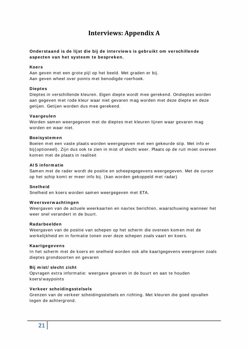
Interviews: Appendix A
Onderstaand is de lijst die bij de interviews is gebruikt om verschillende aspecten van het systeem te bespreken.
Koers Aan geven met een grote pijl op het beeld. Met graden er bij. Aan geven wheel over points met benodigde roerhoek.
Dieptes Dieptes in verschillende kleuren. Eigen diepte wordt mee gerekend. Ondieptes worden aan gegeven met rode kleur waar niet gevaren mag worden met deze diepte en deze getijen. Getijen worden dus mee gerekend.
Vaargeulen Worden samen weergegeven met de dieptes met kleuren lijnen waar gevaren mag worden en waar niet.
Boeisystemen Boeien met een vaste plaats worden weergegeven met een gekeurde stip. Met info er bij(optioneel). Zijn dus ook te zien in mist of slecht weer. Plaats op de ruit moet overeen komen met de plaats in realiteit
AIS informatie Samen met de rader wordt de positie en scheepsgegevens weergegeven. Met de cursor op het schip komt er meer info bij. (kan worden gekoppeld met radar)
Snelheid Snelheid en koers worden samen weergegeven met ETA.
Weersverwachtingen Weergaven van de actuele weerkaarten en navtex berichten, waarschuwing wanneer het weer snel verandert in de buurt.
Radarbeelden Weergaven van de positie van schepen op het scherm die overeen komen met de werkelijkheid en in formatie tonen over deze schepen zoals vaart en koers.
Kaartgegevens In het scherm met de koers en snelheid worden ook alle kaartgegevens weergeven zoals dieptes grondsoorten en gevaren
Bij mist/slecht zicht Opvragen extra informatie: weergave gevaren in de buurt en aan te houden koers/waypoints
Verkeer scheidingsstelsels Grenzen van de verkeer scheidingsstelsels en richting. Met kleuren die goed opvallen tegen de achtergrond.
22
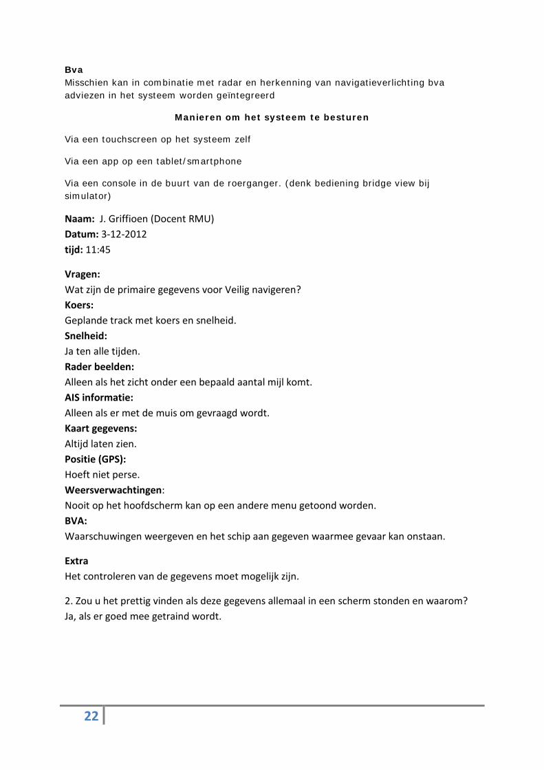
Bva Misschien kan in combinatie met radar en herkenning van navigatieverlichting bva adviezen in het systeem worden geïntegreerd
Manieren om het systeem te besturen
Via een touchscreen op het systeem zelf
Via een app op een tablet/smartphone
Via een console in de buurt van de roerganger. (denk bediening bridge view bij simulator)
Naam: J. Griffioen (Docent RMU) Datum: 3-12-2012 tijd: 11:45
Vragen: Wat zijn de primaire gegevens voor Veilig navigeren? Koers: Geplande track met koers en snelheid. Snelheid: Ja ten alle tijden. Rader beelden: Alleen als het zicht onder een bepaald aantal mijl komt. AIS informatie: Alleen als er met de muis om gevraagd wordt. Kaart gegevens: Altijd laten zien. Positie (GPS): Hoeft niet perse. Weersverwachtingen: Nooit op het hoofdscherm kan op een andere menu getoond worden. BVA: Waarschuwingen weergeven en het schip aan gegeven waarmee gevaar kan onstaan.
Extra Het controleren van de gegevens moet mogelijk zijn.
2. Zou u het prettig vinden als deze gegevens allemaal in een scherm stonden en waarom? Ja, als er goed mee getraind wordt.
23
Naam: W. van Pruissen (docent RMU) Datum: 15-11-2012 tijd: 12:00
Vragen: 1. Wat zijn de primaire gegevens voor Veilig navigeren? Koers: Altijd laten zien met rate of turn, zijwaartse beweging en wind snelheid en richting. Snelheid: ja ten alle tijden. Rader beelden: Alleen in druk gebieden, aanloop en vertrek. AIS informatie: Alleen als er met de muis om gevraagd wordt. Kaart gegevens: zijn bij de reisvoorbereiding al gecontroleerd dus alleen laten zien als er wordt afgeweken van de koers. Positie (GPS): Altijd laten zien. Weersverwachtingen: Nooit op het hoofdscherm kan op een andere menu getoond worden. BVA: Als het mogelijk is kan het getoond worden als waarschuwing of als hulp.
Extra Onderscheid maken tussen drukke vaargebieden aanloop en vertrekgebieden. Alles daar buiten kan als rustig worden beschouwt.
2. Zou u het prettig vinden als deze gegevens allemaal in een scherm stonden en waarom? Ja alleen als het wel over heel de brug verkrijgbaar is en klopt met de omgeving.
24
Naam: H. Mastenbroek (kapitein Meander/ voormalig verkeersleider Rijkswaterstaat) Datum: 16-12-2012 tijd: 13:00
Vragen: 1. Wat zijn de primaire gegevens voor Veilig navigeren? Koers: Weergeven gecorrigeerde. WOP/rate of turn afhankelijk van manoeuvreereigenschappen schip. (Bij kleinere goed manoeuvreerbare schepen zal dit niet nodig zijn). Eta naar volgend waypoint (moet uit te schakelen zijn) Snelheid: Ja Rader beelden: Als onderliggende laag. AIS informatie: Gekoppeld aan radar informatie: standaard de scheepsnaam+cpa/tcpa en koers/vaart weergeven. Pop up scherm voor aanvullende informatie Kaart gegevens: Alleen diepgang. Dit gekoppeld aan eigen diepgangsgegevens. (handmatig of elektronisch bepaald). Duidelijke kleurindicaties met waarschuwingen voor gevaar. Positie (GPS): Altijd laten zien. Weersverwachtingen: Als op te roepen informatie. BVA: Gedeeltelijk BVA: dat wil zeggen aangeven wanneer volgens de regels uitgeweken moet worden. Beslissing overlaten aan Officier van de Wacht. Boeisystemen/verkeers scheidings stelsels: Boeien aangeven in het systeem met hun topteken zodat onmiddellijk duidelijk is welke boei er is. Daarnaast moeten boeien aanklikbaar zijn om zo informatie te krijgen over naam/karakter etc. Misschien kan een kleur worden toegevoegd die overeenkomt met de kleur van een VSS in de kaart. Lichtenlijnenen/ sectorlichten: Deze zouden bij beperkt zicht kunnen worden getoond op het AR systeem overeenkomstig met hun locatie in werkelijkheid. Extra Van belang is dat het scherm zo rustig mogelijk gehouden moet worden. Bediening met tablet/touchscreen zou voorkeur hebben. Zeker de tablet biedt mogelijkheden om het overzicht te behouden en ook controlemogelijkheden te bieden aan de kapitein.
25
2. Zou u het prettig vinden als deze gegevens allemaal in een scherm stonden en waarom? Ja alleen als het wel over heel de brug verkrijgbaar is en klopt met de omgeving.
Naam: J.Borgstein (loods, Nederlands loodswezen) Datum: 30-11-2012 tijd: 20:00
Vragen: Wat zijn de primaire gegevens voor Veilig navigeren? Koers: Altijd laten zien gegevens van de koers over de grond. Snelheid: Altijd laten zien gegevens van de snelheid over de grond ETA: Niet weergeven, dit gegeven verandert continue. Diepte: Waarschuwing voor ondieptes, Bepaald met eigen under keel clearance. Vaargeulen: Aangeven met de kleur magenta Rader beelden/Ais informatie: Ander schip pas weergeven wanneer er een bepaalde CPA wordt bereikt die je zelf kan instellen, situatie afhankelijk Kaart gegevens: Niet weergeven, afstand instelbaar maken tot gevaren waarbij er een alarm te voorschijn komt. Mist/slecht zicht: Rate of turn weergeven en pad predictie. Positie (GPS): Altijd laten zien. Weersverwachtingen: In submenu. BVA: Wanneer mogelijk waarschuwen, (denk dat dit erg moeilijk wordt rekening houdend met navigatie verlichting van schepen, dagmerken, geulers) Manier besturen systeem: Door middel van tablet, gegevens van het AR systeem overal op het schip kunnen opvragen via WIFI zodat overal mee gekeken kan worden. Alle gegevens in 1 scherm: Nee, alleen operationele functies zoals koers, snelheid en coördinaten. Alle andere gegevens op te vragen via menu. Extra’s: Drie verschillende mode voor oceaan, drukker bevaren gebied en een mode speciaal voor havens (docking mode): waarin vectoren worden weergeven van het schip beweging naar voor en naar achter beweging van boeg naar bb en sb beweging achterschip bb en sb.


![“creating a pervasive Augmented Reality paradigm, where ...Poither]VENTURI... · O World modelling using consumer-level mobile devices O Mobile contextual understanding ... visual](https://img.pdfslide.us/doc/110x75/5ed3ec49b3851038685737ea/aoecreating-a-pervasive-augmented-reality-paradigm-where-poitherventuri.jpg)