Embed Size (px)
Citation preview

ATTACHMENT F.
ALTERATIONS ANALYSIS FLOW CHARTS
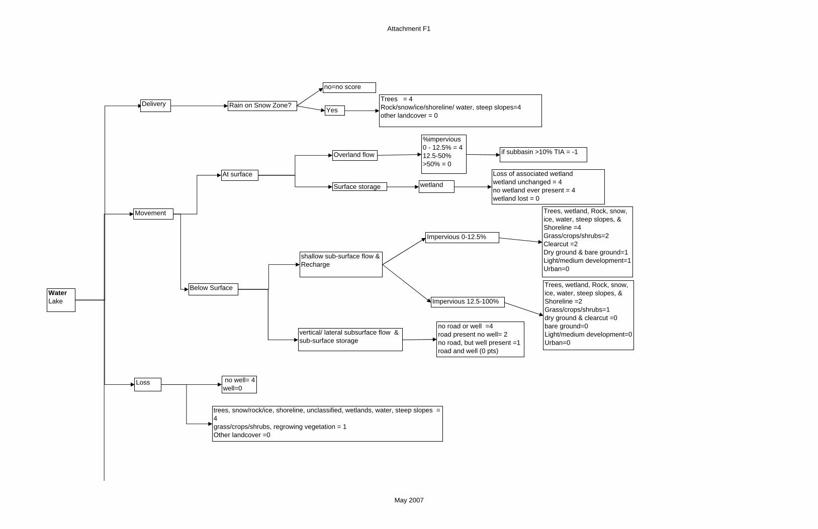
Attachment F1
Trees = 4Rock/snow/ice/shoreline/ water, steep slopes=4other landcover = 0
Delivery
At surface
Loss
Water Lake
Movement
Overland flow if subbasin >10% TIA = -1
Surface storage wetland
Below Surface
shallow sub-surface flow & Recharge
no road or well =4 road present no well= 2no road, but well present =1road and well (0 pts)
vertical/ lateral subsurface flow & sub-surface storage
Loss of associated wetlandwetland unchanged = 4no wetland ever present = 4wetland lost = 0
trees, snow/rock/ice, shoreline, unclassified, wetlands, water, steep slopes = 4grass/crops/shrubs, regrowing vegetation = 1Other landcover =0
Rain on Snow Zone?
no=no score
Yes
Impervious 0-12.5%
Impervious 12.5-100%
Trees, wetland, Rock, snow, ice, water, steep slopes, & Shoreline =4Grass/crops/shrubs=2Clearcut =2Dry ground & bare ground=1Light/medium development=1Urban=0
Trees, wetland, Rock, snow, ice, water, steep slopes, & Shoreline =2Grass/crops/shrubs=1dry ground & clearcut =0bare ground=0Light/medium development=0Urban=0
no well= 4well=0
%impervious 0 - 12.5% = 412.5-50%>50% = 0
May 2007

Attachment F1
Subbasin
TIA of subbasinTIA 0 to1%=4TIA 1 to 3%=3TIA 3 to10%=2TIA >10%= 1
Watershed scale effects-% of subbasin not in forest coverRelative % of basin covered in forest 81% to 100%=461% to 80%=341% to 60% =2 21% to 40% =10% to 20%=0
% wetland loss/alteration within the subbasin (divide range into four equal binsLowest loss=4Second lowest loss= 3Third lowest loss = 2Highest loss = 1
May 2007

Attachment F1
Delivery
At surface
Loss
WaterRiverine
Movement
Overland flow
Surface storage floodplain
wetland
Below Surface
stream reach no diversion/dam* (4 pts)stream reach downstream of diversion/dam* (0 pts)
No levee=4Leeved=0
Trees = 4Rock/snow/ice/shoreline/ steep slopes, water=4other landcover = 0Rain on Snow Zone?
no=no score
Yes
%impervious 0 - 12.5% = 412.5-50%>50% = 0
if subbasin >10% TIA = -1
Loss of associated wetlandwetland unchanged = 4no wetland ever present = 4wetland lost = 0
Dams Stream reaches above or with no dams=4Stream reaches downstream of dams=0
shallow sub-surface flow & Recharge
no road or well =4 road present no well= 2no road, but well present =1road and well = 0
vertical/ lateral subsurface flow & sub-surface storage
Impervious 0-12.5%
Impervious 12.5-100%
trees, snow/rock/ice, shoreline, unclassified, wetlands, water, steep slopes = 4grass/crops/shrubs, regrowing vegetation = 1Other landcover =0
no well= 4well=0
Trees, wetland, Rock, snow, ice, water, steep slopes, & Shoreline =4Grass/crops/shrubs=2Clearcut =2Dry ground & bare ground=1Light/medium development=1Urban=0
Trees, wetland, Rock, snow, ice, water, steep slopes, & Shoreline =2Grass/crops/shrubs=1dry ground & clearcut =0bare ground=0Light/medium development=0Urban=0
road
no
yes = 0
May 2007

Attachment F1
% wetland loss/alteration within the subbasin (divide range into four equal binsLowest loss=4Second lowest loss= 3Third lowest loss = 2Highest loss = 1
Subbasin
TIA of subbasinTIA 0 to1%=4TIA 1 to 3%=3TIA 3 to10%=2TIA 10 to 25%= 1TIA >25%=0
Watershed scale effects-% of subbasin not in forest coverRelative % of basin covered in forest 81% to 100%=461% to 80%=341% to 60% =2 21% to 40% =10% to 20%=0
May 2007

Attachment F1Delivery
At surface
Loss
Water Marine Movement
Below Surface
Continuous Trees=4Continuous Shrubs=3Patchy Trees=2Patchy shrubs or Grass=1none=0
No rain on snow areas in marine environment, Don't score.
Overland flow if subbasin >10% TIA = -1
Surface storage wetland
Loss of associated wetlandwetland unchanged = 4no wetland ever present = 4wetland lost = 0
shallow sub-surface flow & Recharge
vertical/ lateral subsurface flow & sub-surface storage
Impervious 0-12.5%
Impervious 12.5-100%
Trees=4shrubs=2grass=1none=0
Trees=1shrubs=1grass=0none=0
No road =4Road = 0
No Shoreline Armoring =4Sh li i 0
%impervious 0 - 12.5% = 412.5-50%>50% = 0
May 2007

Attachment F2
DeliveryIs shoreline adjacent to major shipping lanes/ ferry traffic?
Is shorelines within high recreational boat traffic area (i.e. marinas)?
Wave Energy Marine
Yes=0
No
yes=0
No=4
Movement Is shoreline armored?
Armoring above OHWM= 4Armoring at OHWM=2Armoring below OHWM=0
no =4
yes
Loss Is there an overwater structures? (i.e. docks)
Yes = 0
No = 4
If boat ramp present = -2
May 2007

Attachment F2
Delivery
Is shoreline on a lake with motorized boat traffic?***
Wave Energy Lake
Yes=0
No=4
Movement Is shoreline armored? (presence of dock)
No dock and not within 2 pixels of a dock= 4
yes
Loss Is there an overwater structures? (i.e. docks)
Yes = 0
No=4
Presence of dock=0Pixel on either side of dock=02 pixels out from either side of dock=1
wind movementtrees/ wetland/ snow/ ice/ rock/ steep slopes, water = 4all other = 0
May 2007
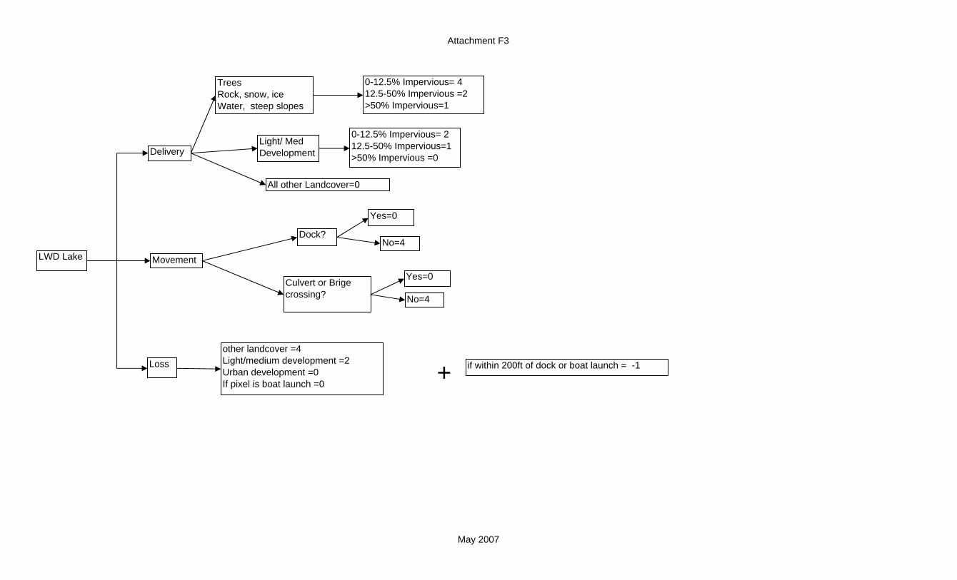
Attachment F3
+
Delivery
Movement
Loss
LWD Lake
if within 200ft of dock or boat launch = -1
other landcover =4Light/medium development =2Urban development =0If pixel is boat launch =0
TreesRock, snow, iceWater, steep slopes
0-12.5% Impervious= 412.5-50% Impervious =2>50% Impervious=1
Light/ Med Development
0-12.5% Impervious= 212.5-50% Impervious=1>50% Impervious =0
All other Landcover=0
Dock?
Yes=0
No=4
Culvert or Brige crossing?
Yes=0
No=4
May 2007

Attachment F3
Shoreline erosion
Movement
Loss
LWD Riverine
+ if within 200ft (alongshore distance) of dock or boat launch -1other landcover =4Light/medium development =2Urban development =0If pixel is boat launch =0
Armored? No
Level of channel confinement?
Confined
Unconfined/Moderately confined
Yes
Channel size?
Small
Large
Gradient >4%Within 100 year floodplain
Gradient <4%=4
Unconfined=3Mod Confined=3 Confined=2
Confined or Moderately confined
Unconfined=4
Armored shoreline =0
Unarmored shoreline =4
Delivery
TreesRock, snow, ice & water, steep slopes
Light/ Med Development
All other Landcover=0
TreesRock, snow, ice & water, steep slopesLight/ Med Development
All other Landcover=0
TreesRock, snow, ice & water, steep slopes
Light/ Med Development
All other Landcover=0
0-12.5% Impervious= 312.5-50% Impervious =2>50% Impervious=1
0-12.5% Impervious= 212.5-50% Impervious=1>50% Impervious =0
0-12.5% Impervious= 412.5-50% Impervious =2>50% Impervious=1
0-12.5% Impervious= 212.5-50% Impervious=1>50% Impervious =0
0-12.5% Impervious= 312.5-50% Impervious =2>50% Impervious=1
0-12.5% Impervious= 1>12.5% Impervious =0
Culvert or Brige crossing?
Yes=0
No=4
Downstream of Dam?
Yes=0
No=4
May 2007

Attachment F3
+
+
Delivery
Continuous trees, adjacent = 3 Patchy trees, adjacent=2Continuous or patchy, separated trees = 2Shrubs, patchy/continuous, separated/adjacent=1none of the above = 0
Movement
Loss
LWD Marine
if within 200ft of dock or boat ramp = -1
Continuous trees adjacent to shoreline = 4Patchy trees adjacent to shoreline=3Shrubs adjacent to shoreline=1none/grass/trees or shrubs separated = 0 pts
Patch trees adjacent = 3Dense trees adjacent = 2none, grass or separated = 0
no armor =4armor above OHWM = 3armor at OHWM = 0armor below OHWM = 0
Low Imperviousness=4Medium Imperviousness=2High Imperviousness =0
Armored?
No
Yes
if 1 or more dock present -1
In Landslide area?
Yes
No
Culvert or Brige crossing?
Yes=0
No=4
May 2007
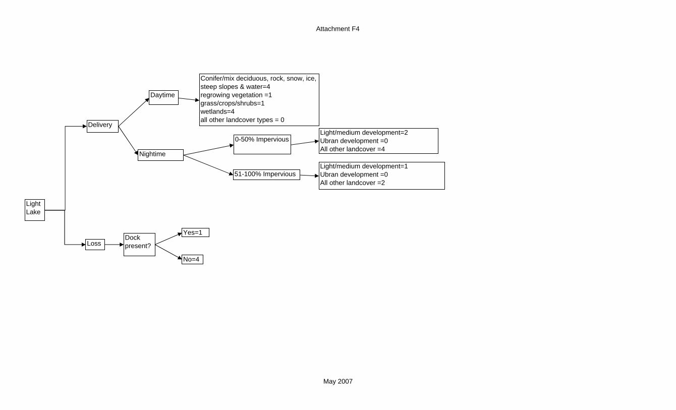
Attachment F4
Delivery
Loss
Light Lake
Conifer/mix deciduous, rock, snow, ice, steep slopes & water=4regrowing vegetation =1grass/crops/shrubs=1wetlands=4all other landcover types = 0
Nightime
Dock present?
Yes=1
No=4
0-50% Impervious
51-100% Impervious
Daytime
Light/medium development=2Ubran development =0All other landcover =4
Light/medium development=1Ubran development =0All other landcover =2
May 2007

Attachment F4
Delivery
Loss
Light River
Dock present?
Yes=1
No=4
Conifer/mix deciduous=4regrowing vegetation =1grass/crops/shrubs=1Rock/snow/ice/shoreline/wetlands/water, steep slopes =4all other landcover types = 0
Nightime
0-50% Impervious
51-100% Impervious
Daytime
Light/medium development=2Ubran development =0All other landcover =4
Light/medium development=1Ubran development =0All other landcover =2
May 2007

Attachment F4
FU
Delivery
Loss
Light Marine
No
Recreational Dock present?
Yes=1
No=4
Marina or ferry terminal Present?
yes=0
No
Marina/ Ferry Terminal ?
Yes=0
Adjacent trees and overhanging =4Adjacent tress and no overhanging =3Other combinations of vegetation and overhanging =0
0-50% Impervious
51-100% Impervious
Day time
Night time
Adjacent, continuous trees or shrubs=4Adjacent, patchy trees or shrubs=2other vegetation combinations=0
Adjacent, continuous trees or shrubs=2Adjacent, patchy trees or shrubs=0other vegetation combinations=0
May 2007

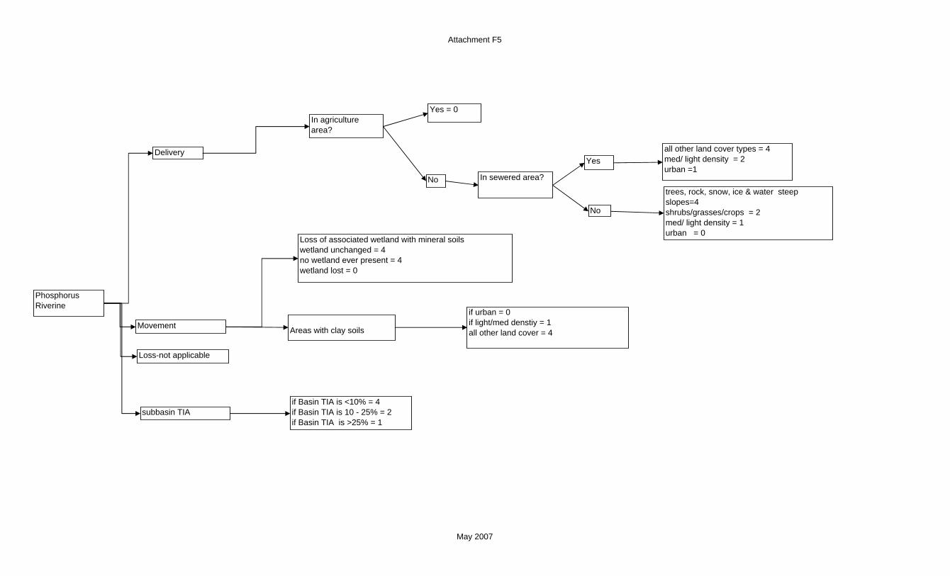
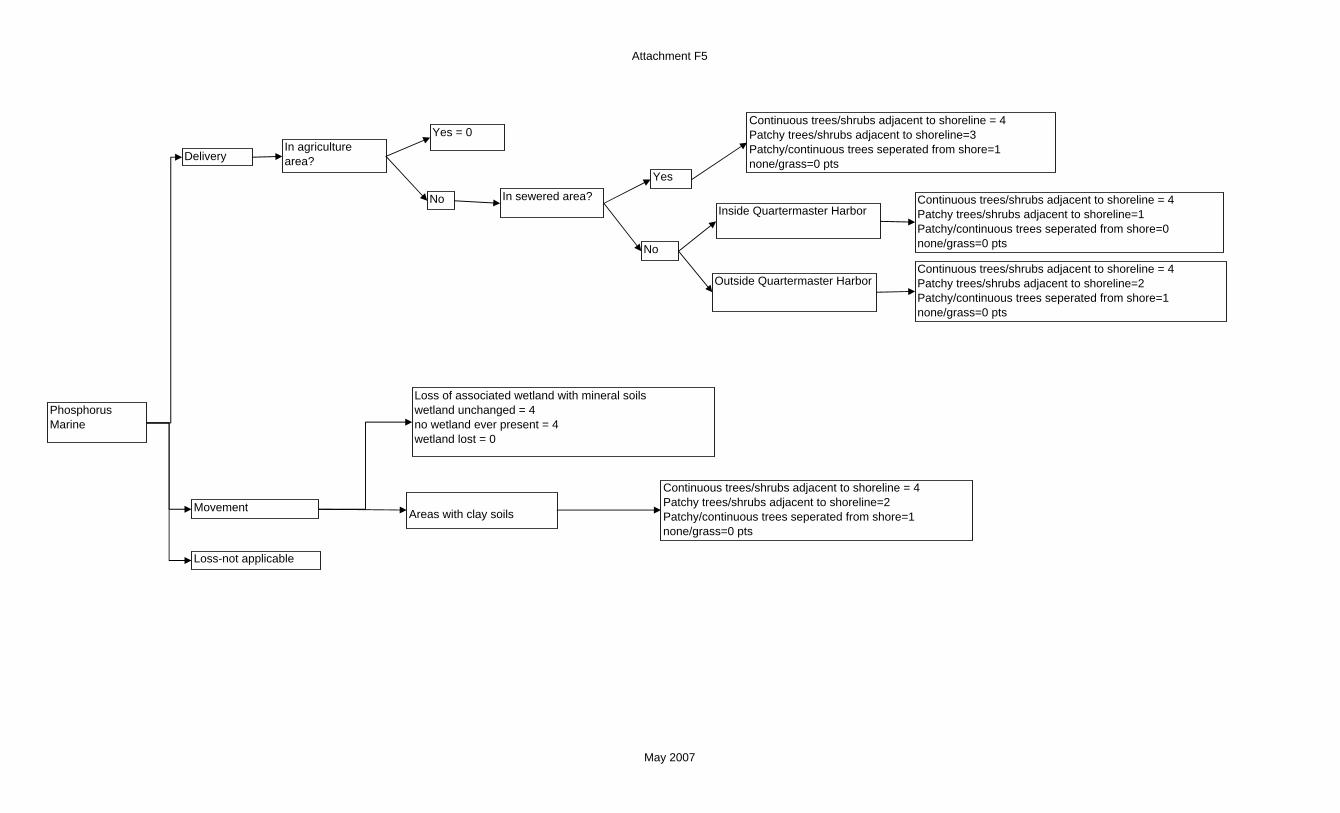
Attachment F5
Delivery
Movement
PhosphorusLake
In agriculture area?
Yes = 0
No
Loss of associated wetland with mineral soilswetland unchanged = 4no wetland ever present = 4wetland lost = 0
No
Yes
if Basin TIA is <10% = 4if Basin TIA is 10 - 25% = 2if Basin TIA is >25% = 1
In sewered area?
Areas with clay soils
if urban = 0if light/med denstiy = 1all other land cover = 4
all other land cover types = 4med/ light density = 2urban =1
trees, rock, snow, ice & water steep slopes=4shrubs/grasses/crops = 2med/ light density = 1urban = 0
Loss-not applicable
Subbasin TIA
wind movementtrees/ wetland/ snow/ ice/ rock/ steep slopes, water = 4all other = 0
May 2007
Attachment F5
Delivery
Movement
PhosphorusRiverine
In agriculture area?
Yes = 0
No
Loss of associated wetland with mineral soilswetland unchanged = 4no wetland ever present = 4wetland lost = 0
No
Yes
In sewered area?
Areas with clay soils
if urban = 0if light/med denstiy = 1all other land cover = 4
all other land cover types = 4med/ light density = 2urban =1
trees, rock, snow, ice & water steep slopes=4shrubs/grasses/crops = 2med/ light density = 1urban = 0
if Basin TIA is <10% = 4if Basin TIA is 10 - 25% = 2if Basin TIA is >25% = 1
subbasin TIA
Loss-not applicable
May 2007
Attachment F5
Delivery
Movement
PhosphorusMarine
In agriculture area?
Yes = 0
No
Loss of associated wetland with mineral soilswetland unchanged = 4no wetland ever present = 4wetland lost = 0
No
Yes
In sewered area?
Areas with clay soils
Inside Quartermaster Harbor
Outside Quartermaster Harbor Continuous trees/shrubs adjacent to shoreline = 4Patchy trees/shrubs adjacent to shoreline=2Patchy/continuous trees seperated from shore=1none/grass=0 pts
Continuous trees/shrubs adjacent to shoreline = 4Patchy trees/shrubs adjacent to shoreline=1Patchy/continuous trees seperated from shore=0none/grass=0 pts
Continuous trees/shrubs adjacent to shoreline = 4Patchy trees/shrubs adjacent to shoreline=2Patchy/continuous trees seperated from shore=1none/grass=0 pts
Continuous trees/shrubs adjacent to shoreline = 4Patchy trees/shrubs adjacent to shoreline=3Patchy/continuous trees seperated from shore=1none/grass=0 pts
Loss-not applicable
May 2007

Attachment F6
Delivery
Movement/Loss
Total Nitrogen Lake
In agriculture area?
Yes = 0 pts
No
Loss of associated wetlandwetland unchanged = 4no wetland ever present = 4wetland lost = 0
In sewered area?trees, rock, snow, ice, water & wetlands, steep slopes =4shrubs/grasses/crops = 2med/ light density = 1urban = 0
No
Yes all other land cover types = 4med/ light density = 2urban =1
Channelized streamYes = 0No = 4
May 2007

Attachment F6
Delivery
Movement/Loss
Total Nitrogen Riverine
In agriculture area?
Yes = 0 pts
No
Loss of associated wetlandwetland unchanged = 4no wetland ever present = 4wetland lost = 0
In sewered area?
No
Yes all other land cover types = 4 med/ light density = 2urban=1
Channelized streamYes = 0No = 4
trees=4 shrubs/grasses/crops = 2med/ light density = 1urban = 0Other landcover types=4
May 1007

Attachment F6
Delivery
Movement/Loss
Total Nitrogen Marine
In agriculture area?
Yes = 0 pts
No
Loss of associated wetlandwetland unchanged = 4no wetland ever present = 4wetland lost = 0
In sewered area?
Inside Quartermaster Harbor
No
Yes
Channelized streamYes = 0No = 4
Outside Quartermaster Harbor
Continuous trees/shrubs adjacent to shoreline = 4Patchy trees/shrubs adjacent to shoreline=3Patchy/continuous trees seperated from shore=1none/grass=0 pts
Continuous trees/shrubs adjacent to shoreline = 4Patchy trees/shrubs adjacent to shoreline=2Patchy/continuous trees seperated from shore=1none/grass=0 pts
Continuous trees/shrubs adjacent to shoreline = 4Patchy trees/shrubs adjacent to shoreline=1Patchy/continuous trees seperated from shore=0none/grass=0 pts
May 2007

Attachment F7
Delivery
Movement/Loss
PathogensLake
In agriculture area?
Wetlands
horticulture = 4unspecified ( treat as not in ag)mixed crop/ livestock = 3dairy = 0livestock = 0
In sewered area?No
Yes
No
Yesall land cover types = 4public beaches and parks = 0
loss of depressional wetlandwetland unchanged = 4no wetland ever present = 4wetland lost = 0
ditched watercourse or roads
No = 4
Yes = 0
if Basin TIA is <10% = 4if Basin TIA is 10 - 25% = 1if Basin TIA is >25% = 0
trees/shrubs, grasses not in sewered area = 4med/ light density not in sewered area = 2urban not in sewered area = 0public beaches and parks = 0Other landcover types=4
May 2007

Attachment F7
Delivery
Movement/Loss
PathogensRiver
In agriculture area?
Wetlands
trees/shrubs, grasses not in sewered area = 4med/ light density not in sewered area = 2urban not in sewered area = 0public beaches and parks = 0Other landcover types=4
horticulture = 4unspecified ( treat as not in ag)mixed crop/ livestock = 3dairy = 0livestock = 0
In sewered area?No
Yes
No
Yesall landcover types = 4public beaches and parks = 0
loss of depressional wetlandwetland unchanged = 4no wetland ever present = 4wetland lost = 0
ditched watercourse or roads
No = 4
Yes = 0
if Basin TIA is <10% = 4if Basin TIA is 10 - 25% = 1if Basin TIA is >25% = 0
May 2007

Attachment F7
Delivery
Movement/Loss
PathogensMarine
Marinas ?
horticulture = 4unspecified ( treat as not in ag)mixed crop/ livestock = 2dairy = 0livestock = 0
no = 4yes = 0
In agriculture area?
No
Yes
loss of associated wetlandwetland unchanged = 4no wetland ever present = 4wetland lost = 0
In sewered area?Yes = 4
no
ditched watercourse or roads
No = 4
Yes = 0
if Basin TIA is <10% = 4if Basin TIA is 10 - 25% = 1if Basin TIA is >25% = 0
Inside Quartermaster
Outside Quartermaster Harbor
Continuous trees/shrubs adjacent to shoreline = 4Patchy trees/shrubs adjacent to shoreline=2Patchy/continuous trees seperated from shore=1none/grass=0
Continuous trees/shrubs adjacent to shoreline = 4Patchy trees/shrubs adjacent to shoreline=1Patchy/continuous trees seperated from shore=0none/grass=0
Draft December 2006

Attachment F8
Delivery
Movement/Loss
ToxinsLake
Trees, rock, snow, ice, steep slopes & water = 4Light/medium density = 1Urban density = 0all other land use types = 3
Boats?
In agriculture area?
horticultural = 0Crops/ livestock = 0dairy = 1livestock = 1Unspecificed (evaluate under "no")
No
Yes
CSO?Yes = 0No = 4
Loss of associated wetland with organic or clay soilswetland unchanged = 4no wetland ever present = 4wetland lost = 0
Road?No road=4Road between 100 and 200 ft=2Road within first 100 feet =0
Loss-not applicable
% impervious0-12.5% = 412.5-50%=2>50% = 0
High = 0low = 2none = 0
May 2007

Attachment F8
Delivery
Movement
ToxinsRiverine
% impervious0-12.5% = 412.5-50%=2>50% = 0
Boats?boats allowed = 0no outboard allowed = 4
In agriculture area?
horticultural = 0Crops/ livestock = 0dairy = 1livestock = 1Unspecificed (evaluate under "no")
No
Yes
CSO?High = 0low = 2none = 0
Road?No road=4Road between 100 and 200 ft=2Road within first 100 feet =0
Trees & rock, snow, ice steep slopes= 4Light/medium density = 1Urban density = 0all other land use types = 3
Loss of associated wetland with organic or clay soilswetland unchanged = 4no wetland ever present = 4wetland lost = 0
Loss-not applicable
May 2007

Attachment F8
Movement
ToxinsMarine
Marinas ?
CSO ?
% impervious
Wetlands
no = 4yes = 0
no = 4yes = 0
In agriculture area?
No
Yes = 0
Delivery
Road?No road=4Road between 100 and 200 ft=2Road within first 100 feet =0
Low Imperviousness=4Medium Imperviousness=1High Imperviousness =0
Continuous trees/shrubs adjacent to shoreline = 4Patchy trees/shrubs adjacent to shoreline=3Patchy/continuous trees seperated from shore=1none/grass=0 pts
Loss of associated wetland with organic or clay soilswetland unchanged = 4no wetland ever present = 4wetland lost = 0
Loss-not applicable
May 2007

Attachment F9
Delivery not applicable
Tidal RegimeMarine Movement Is there tidal
encroachment?
Armoring above OHWM = 3Armoring at OHWM =1Armoring below OHWM = 0
No =4
yes
Loss not applicable
is there a tidal constriction?
Marine outfall = 0 Culvert within 100 feet of shore = 0Weir present = 0Bulkhead stream barriers = 0All other shoreline pixels = 4
TIA of basin 0 to 10%=4TIA of basin 10 to 25%=1TIA of Basin >25%=0
May 2007
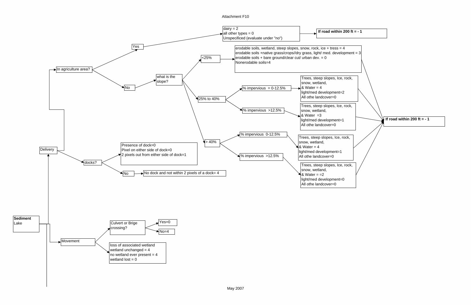
Attachment F10
In agriculture area?
Movement
Sediment Lake
loss of associated wetlandwetland unchanged = 4no wetland ever present = 4wetland lost = 0
dairy = 2all other types = 0Unspecificed (evaluate under "no")
No
Yes
Delivery
docks?
No
If road within 200 ft = - 1
erodable soils, wetland, steep slopes, snow, rock, ice + tress = 4erodable soils +native grass/crops//dry grass, light/ med. development = 3erodable soils + bare ground/clear cut/ urban dev. = 0 Nonerodable soils=4
<25%
25% to 40%
Trees, steep slopes, Ice, rock, snow, wetland,& Water = 4light/med development=2All othe landcover=0
% impervious = 0-12.5%
If road within 200 ft = - 1
what is the slope?
> 40%
% impervious >12.5%Trees, steep slopes, Ice, rock, snow, wetland,& Water =3light/med development=1All othe landcover=0
Trees, steep slopes, Ice, rock, snow, wetland,& Water = 4light/med development=1All othe landcover=0
% impervious 0-12.5%
% impervious >12.5%
Trees, steep slopes, Ice, rock, snow, wetland,& Water = =2light/med development=0All othe landcover=0
No dock and not within 2 pixels of a dock= 4
Presence of dock=0Pixel on either side of dock=02 pixels out from either side of dock=1
Culvert or Brige crossing?
Yes=0
No=4
May 2007
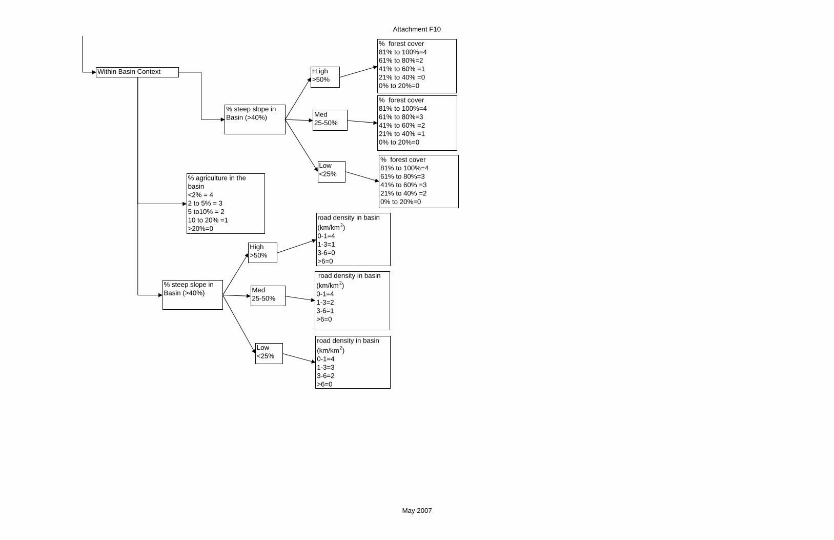
Attachment F10
Within Basin Context
road density in basin (km/km2)0-1=41-3=13-6=0>6=0
% steep slope in Basin (>40%) Med
25-50%
Low <25%
High >50%
road density in basin (km/km2)0-1=41-3=23-6=1>6=0
road density in basin (km/km2)0-1=41-3=33-6=2>6=0
% forest cover81% to 100%=461% to 80%=241% to 60% =121% to 40% =00% to 20%=0
% steep slope in Basin (>40%) Med
25-50%
Low <25%
H igh >50%
% forest cover81% to 100%=461% to 80%=341% to 60% =221% to 40% =10% to 20%=0
% forest cover81% to 100%=461% to 80%=341% to 60% =321% to 40% =20% to 20%=0
% agriculture in the basin<2% = 42 to 5% = 35 to10% = 210 to 20% =1>20%=0
May 2007

Attachment F10
SedimentRiverine
Delivery
Shoreline erosion
Armored?
Dam?
No
Basin %TIA<10%=110%-25%=0>25%=0
yes
In agriculture area?erodable soils + wetland, steep slopes, snow, rock, ice ,tress = 4erodable soils +native grass/crops//dry grass, light/ med. development = 3erodable soils + bare ground/clear cut/ urban dev. = 0 Non-erodable soils=4
dairy = 2all other types = 0Unspecificed (evaluate under "no")
Yes
<25%
25% to 40%
Trees, Ice/rock/snow, steep slopes &wetland =4light/med development=2All other landcover=0Water = 4
% impervious = 0-12.5%
If road within 200 ft = - 1
+ If road within 200 ft = - 1
No what is the slope?
> 40%
% impervious >12.5%
Trees, Water, Ice, rock, snow steep slopes &wetland =3light/med development=1All othe landcover=0
Trees, steep slopes, Ice, rock, snow, wetland,& Water = 4light/med development=1All othe landcover=0
% impervious 0-12.5%
% impervious >12.5% Trees, steep slopes, Ice, rock, snow, wetland,& Water = 2light/med development=0All othe landcover=0
noBasin %TIA<10%=210%-25%=1>25%=0
Basin %TIA<10%=410%-25%=3>25%=1
yes
Dam?yes
no
May 2007

Attachment F10
Movement
(Floodplain impacts) Levee?
Yes = 0
No channelized
Yes = 0
No = 4(In-channel impacts)Armored?
loss of associated wetlandwetland unchanged = 4no wetland ever present = 4wetland lost = 0
Loss not applicable
Basin Context
% agriculture in the basin<5% = 46-20 = 320-50% = 2>50% =0
Yes = 0
No = 4
road density in basin (km/km2)0-1=41-3=13-6=0>6=0
% steep slope in Basin (>40%) Med
25-50%
Low <25%
High >50%
road density in basin (km/km2)0-1=41-3=23-6=1>6=0
road density in basin (km/km2)0-1=41-3=33-6=2>6=0
% forest cover81% to 100%=461% to 80%=241% to 60% =121% to 40% =00% to 20%=0
% steep slope in Basin (>40%)
Med 25-50%
Low <25%
H igh >50%
% forest cover81% to 100%=461% to 80%=341% to 60% =221% to 40% =10% to 20%=0
% forest cover81% to 100%=461% to 80%=341% to 60% =321% to 40% =20% to 20%=0
Culvert or Brige crossing?
Yes=0
No=4
May 2007
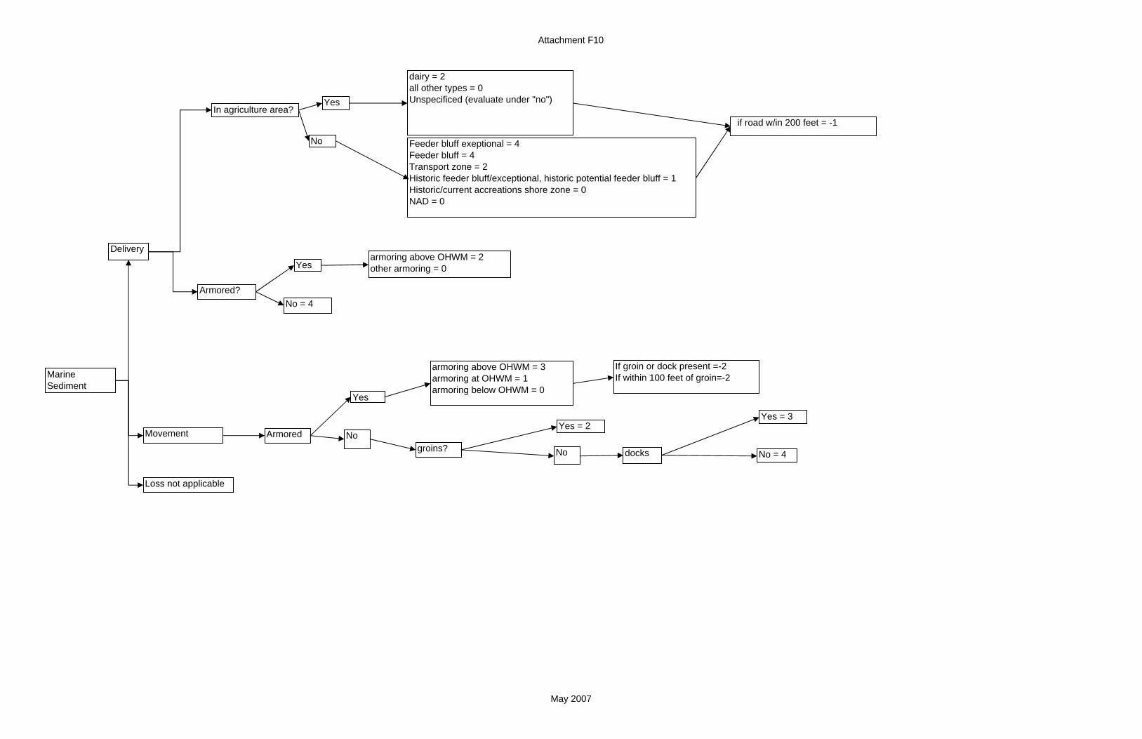
Attachment F10
Delivery
Armored?
Feeder bluff exeptional = 4Feeder bluff = 4Transport zone = 2Historic feeder bluff/exceptional, historic potential feeder bluff = 1Historic/current accreations shore zone = 0NAD = 0
Movement
armoring above OHWM = 2other armoring = 0
MarineSediment
if road w/in 200 feet = -1In agriculture area?
No
Yes
dairy = 2all other types = 0Unspecificed (evaluate under "no")
No = 4
Yes
Armored
armoring above OHWM = 3armoring at OHWM = 1armoring below OHWM = 0
No
Yes
groins? No
Yes = 2
docks No = 4
Yes = 3
If groin or dock present =-2If within 100 feet of groin=-2
Loss not applicable
May 2007