Embed Size (px)
Citation preview

Attachment 4 – Thornlie-Cockburn Link Inland Waters – Additional Information report (PTA, 2019a)

Thornlie-Cockburn Link Inland Waters – Additional Information June 2019
For more information contact Public Transport Authority
Public Transport Centre, West Parade, Perth WA 6000
PO Box 8125, Perth Business Centre, Perth WA 6849
Telephone: (08) 9326 2000
Email: [email protected] www.pta.wa.gov.au
Rev Date Author Reviewer(s) Description
A 18/06/2019 R. Burnell
L. Zimmermann
D. Cahill
C. Stedman
Draft – first version
0 27/06/2019 L. Zimmermann
S. Brown
D. Cahill
C. Stedman
M. Ludlow
Final

Public Transport Authority Thornlie-Cockburn Link 2
Contents
1. Introduction ............................................................................................................................ 4
1.1 Background ...................................................................................................................... 4
1.2 Objective .......................................................................................................................... 5
1.3 Scope ............................................................................................................................... 6
1.4 Report Structure ............................................................................................................... 6
2. Public Drinking Water Source Areas .................................................................................... 7
2.1 Protection areas ............................................................................................................... 7
2.2 Underground Water Pollution Control Areas and Wellhead Protection Zones ................... 7
3. Intersection with Kwinana Freeway .................................................................................... 10
3.1 Project Activities ............................................................................................................. 10
3.2 Potential Impacts ............................................................................................................ 10
3.3 Management Measures .................................................................................................. 11
4. Karel Avenue – Drainage Basins and Construction Area ................................................. 13
4.1 Project Activities ............................................................................................................. 13
4.2 Potential Impacts ............................................................................................................ 14
4.3 Management Measures .................................................................................................. 15
5. Ranford Road Station .......................................................................................................... 17
5.1 Project Activities ................................................................................................................. 17
5.2 Potential Impacts ............................................................................................................ 18
5.3 Management Measures .................................................................................................. 19
6. Nicholson Road Station ...................................................................................................... 22
6.1 Project Activities ............................................................................................................. 22
6.2 Potential Impacts ............................................................................................................ 22
6.3 Management Measures .................................................................................................. 23
7. Tom Bateman Reserve Temporary Construction Area and Pedestrian Footbridge ........ 25
7.1 Project Activities ............................................................................................................. 25
7.2 Potential Impacts ............................................................................................................ 27
7.3 Management Measures .................................................................................................. 29
8. Thornlie Station ................................................................................................................... 31
8.1 Project Activities ............................................................................................................. 31
8.2 Potential Impacts ............................................................................................................ 31
8.3 Management Measures .................................................................................................. 31
9. Canning River Rail Bridge Duplication and Construction Area ........................................ 32
9.1 Project Activities ............................................................................................................. 32

3
9.2 Potential Impacts ............................................................................................................ 35
9.3 Management Measures .................................................................................................. 36
10 References ............................................................................................................................. 40
Figures......................................................................................................................................... 41
Public Transport Authority Thornlie-Cockburn Link 4
1. Introduction 1.1 Background
The Thornlie-Cockburn Link (TCL) Project was referred to the Environmental Protection Authority
(EPA) on 7 June 2018. On 2 July, the EPA set the level of assessment for the proposal at Referral
Information (s39A (2) (b) with Additional Information (s0(2)(a)). The preliminary key environmental
factors were: Flora and Vegetation, Terrestrial Environmental Quality, Terrestrial Fauna,
Hydrological Processes, Inland Waters and Social Surroundings. The Proposal, herein referred to
as the project, is currently being assessed by the EPA.
The Public Transport Authority’s (PTA) proposal comprises construction of a 14.5 kilometre (km)
new dual railway track within existing railway and road reserves, to extend the existing Thornlie
spur line to Cockburn Central Station as well as the duplication of 3 km of railway track between
Beckenham Junction and Thornlie train station. The project also includes the following:
Construction of two new stations: Ranford Road Station and Nicholson Road Station;
Modification of two existing stations: Thornlie Station and Cockburn Central Station; and
Modifications to one rail bridge, two road bridges and the grade separation of a pedestrian
crossing.
Further information relating to potential impacts and associated management measures are
required for the Inland Waters environmental factor.
A workshop was held on 29 May 2019 with staff from the PTA, two branches of the Department of
Water and Environmental Regulation (DWER) EPA Services and Water Planning Advice and the
Department of Biodiversity, Conservation and Attractions (DBCA) Rivers and Estuaries division.
The PTA currently has limited information on the final design and construction methodology for the
project, as a contractor has not yet been appointed. Therefore, the aim of the workshop was to
identify key activities which have the potential to impact environmental values associated with the
Inland Waters environmental factor, and propose realistic management measures. In particular, the
potential impacts to nearby sensitive groundwater dependent ecosystems were discussed.
1.1.1 Preliminary Hydrogeological Assessment
The PTA commissioned Golder to undertake a Preliminary Hydrogeological Assessment for the
project (Golder 2019). The objective of this assessment was to provide information on the sensitive
groundwater dependent ecosystems in proximity to the project and present appropriate
contingency and mitigation measures for implementation (if required to address potential impacts).
A set of criteria were development to assess the potential risk from dewatering and abstraction
bores on the project.
Golder (2019) provides an assessment of the potential impacts to Inland Waters along the project
alignment using three risk categories, summarised in Table 1. Figures are provided in Golder
(2019).

5
Table 1: Golder risk assessment category definitions
Colour category
Risk Percentage of risk category within the development envelope (%)
Red Groundwater abstraction wells are not recommended to be located in these areas as there is an unacceptable risk of detrimental impacts to groundwater and/or environmental values from abstraction. This is predominantly based on the presence of public drinking water bores, conservation wetlands or Banksia Woodlands within the vicinity of these areas (Golder 2019).
27
Orange The risk of detrimental impacts to groundwater and/or environmental values from abstraction is considered manageable through additional investigations and by using trigger driven contingency measures to manage the risk.
20
Green The risk of detrimental impacts to groundwater and/or environmental values from abstraction is considered acceptable (transient or negligible).
53
It has been assessed that sufficient well locations along the project alignment exist, where the
temporary impact of abstracting groundwater can be considered acceptable or managed without
causing detrimental environmental impacts.
The assessment concludes that it will be possible to meet the temporary construction water
requirements of the project through groundwater abstraction from the Superficial Aquifer.
1.1.2 Groundwater Abstraction Locations
The current concept design allows for four abstraction bore locations along the project alignment.
The locations of these bores are indicative and will be finalised by the construction contractor.
The PTA can confirm that no abstraction points will be located in those areas identified as
“unacceptable” (Red category) or “manageable” (Orange category) impact. All abstraction points
will be located within areas considered “acceptable” (Green category) in accordance with Golder
(2019).
As per the Rights in Water and Irrigation Act 1914, the project will require a hydrogeological
investigation to support the application, consistent with Operational Policy No. 5.12 –
Hydrogeological reporting associated with a groundwater well licence (DWER, Nov 2009). The
construction contractor will undertake a H2 or H3 hydrogeological assessment as required and will
apply for required permits/licences.
1.2 Objective
The objective of this report is to provide additional information regarding potential impacts and
management measures to allow EPA Services to complete its assessment against the
environmental objective for Inland Waters.
Public Transport Authority Thornlie-Cockburn Link 6
1.3 Scope
This report provides additional information on the following items in relation to the project, which
were outcomes of the workshop with the PTA, DWER and DBCA:
Locations of likely dewatering activities
Groundwater abstraction activities
Drainage management
Construction activities
Construction areas (including limestone hardstand areas)
Management of construction activities within an Underground Water Pollution Control Area
(UWPCA) and a Well Head Protection Zone (WHPZ).
For each of the above project activities, an assessment of potential impacts is provided as well as
application of the residual significant impact model which considers the application of avoidance,
minimisation and rehabilitation under a range of construction scenarios.
Potential environmental impacts are discussed with reference to the following environmental
receptors that directly or indirectly interact with Inland Waters, including groundwater and surface
water:
UWPCAs and WHPZs.
Groundwater users
Aquatic groundwater dependent ecosystems (GDEs):
o Various wetlands including Conservation Category, Resource Enhancement and
Multiple Use Wetlands
o The Canning River
Terrestrial GDEs including Banksia Woodlands.
The information in this report is additional to the information presented in the Referral Information
with Additional Information Report (Aurora Environmental 2019a) and the TCL Construction
Environmental Management Plan (Aurora Environmental 2019b).
1.4 Report Structure
This report is structured based on seven key locations within the proposal’s development envelope
where project activities have the potential to impact Inland Waters. Working from West to East,
these include:
Chapter 3 – Intersection with Kwinana Freeway
Chapter 4 – Karel Avenue – Drainage Basin and Construction Area
Chapter 5 – Ranford Road Station
Chapter 6 – Nicholson Road Station
Chapter 7 – Tom Bateman Reserve Construction Area and Pedestrian Footbridge
Chapter 8 – Thornlie Station
Chapter 9 – Canning River Rail Bridge Duplication and Construction Area

7
2. Public Drinking Water Source Areas Public drinking water source areas (PDWSAs) are surface water catchments and groundwater
areas that provide drinking water to cities, towns and communities throughout the state. PDWSAs
are proclaimed under the Metropolitan Water Supply, Sewerage, and Drainage Act 1909 or the
Country Areas Water Supply Act 1947. Groundwater sources are normally referred to as
underground water pollution control areas or water reserves. Surface water sources are generally
referred to as catchment areas (Government of Western Australia 2019).
2.1 Protection areas
Priority 1 (P1) source protection areas are defined to ensure that there is no degradation of the
water source. P1 areas are declared over land where the provision of high quality public drinking
water is the prime beneficial land use. P1 areas typically include land under public ownership. P1
areas are protected in accordance with the objective of risk avoidance.
Priority 2 (P2) source protection areas are defined to ensure that there is no increased risk of
pollution to the water source. P2 areas are declared over land where low intensity development
(such as pasture and dry-land cropping) exists. Protection of public water supply sources is also a
high priority relative to other land use values in these areas. P2 areas are protected in accordance
with the objective of risk minimisation.
Priority 3 (P3) source protection areas are defined where it is necessary to manage the risk of
pollution to the water source, and where water supply sources need to co-exist with other existing
land uses such as residential, commercial and light industrial developments. P3 areas generally
include the requirement for use of best available environmental management practice and
connection to deep sewerage. P3 areas are protected in accordance with the objective of risk
management.
The following Protection areas are located within or within the vicinity of the development envelope
and are discussed in detail later in this report:
The section of the project between the Kwinana Freeway and Jandakot is within the
UWPCA and traverses Priority 1 and Priority 3 designated areas (Figure 1a, Figure 2a and
2b).
Kwinana Freeway stormwater drainage basin is located within a P1 and P2 UWPCA and a
WHPZ (Figure 1a).
The south western portion of the Karel Avenue construction area is sited within a P1
UWPCA (Figure 2a).
2.2 Underground Water Pollution Control Areas and Wellhead
Protection Zones
An UWPCA is a specific type of PDWSA. The current boundaries of the Perth Coastal and Gwelup
UWPCAs were established in 1990 through proclamation under the Metropolitan Water Supply,
Sewerage, and Drainage Act 1909. A P3 area was assigned over both control areas. This included
a 300 m radius WHPZ around each production bore.
WHPZs are defined around groundwater abstraction bores. In the absence of modelled alternative
zone shapes, WHPZ in P1 areas are set at a 500 metre radius around bores, and in P2 or P3
areas they are set at a 300 metre radius around bores.
The eastern portion of the proposed Kwinana Freeway drainage basin is located within a WHPZ
(Figure 1a).

Public Transport Authority Thornlie-Cockburn Link 8
Activities within UWPCA and WHPZs are summarised in Chapters 3 to 9 of this report.
2.2.1 Management within UWPCA and WHPZs
In accordance with Government of Western Australia (2016), the following activities are prohibited
within the UWPCA and WHPZs:
Storage of dangerous goods/chemicals.
Storage of mobile or permanent (>12 months) fuel storage tanks.
Installation/storage of underground chemical storage tanks (equal to or greater than 250
L).
Discharge of stormwater or groundwater.
Refuelling, repair or maintenance of vehicles.
Location of onsite wastewater treatment systems.
Use or stockpiling of landscaping materials that include organic matter rich soils and
mulches.
Concrete wash down activities.
The following management measures are proposed to manage impacts to UWPCA and/or WHPZs:
Drainage basin overflow to be directed away from P1 UWPCA and WHPZs.
Consult with the Water Corporation and DWER during construction of the project in the
UWPCA and WHPZ for Production Bore J400.
No prohibited activities (e.g. abstraction, discharge) will occur within the UWPCA and
WHPZ.
Locate abstraction points outside of the Jandakot Mound UWPCA.
Develop detailed drainage designs in accordance with the principles contained in the
following guidelines and advice from the DWER Urban Water Branch throughout the
design and construction of drainage infrastructure:
o Decision process for stormwater management in Western Australia,
November 2017 (DWER, 2017).
o Stormwater Management Manual for Western Australia 2004-07 (DoE,
2004).
o Water Sensitive Urban Design (WSUD) brochures published by the DWER
and available online.
Consideration of WSUD and management of impacts to the UWPCA and associated
WHPZ in the early planning phase.
Incorporate WSUD guidance documents into procurement and contractual
documentation.
Implement the following Water Quality Protection Notes (WQPN) that are of relevance to
‘railway’ land uses, as identified in DWER’s Land Use Compatibility Tables for Public
Drinking Water Source Areas (DoW, 2016):
o Contaminant Spills – Emergency Response (DoW, 2006a)
o Roads Near Sensitive Water Resources (DoW, 2006b)
9
o Tanks for Fuel and Chemical Storage Near Sensitive Water Resources
(DWER, 2018c)
o Infrastructure Corridors Near Sensitive Water Resources (DoW, 2007).
Incorporate management actions to avoid potential impacts to the groundwater and
WHPZ within the PTA’s Construction Environmental Management Plan (CEMP) and the
Contractor’s CEMP.
Locate groundwater abstraction bores a suitable distance from other groundwater bore
users and Water Corporation production bores.
PTA to maintain the railway stormwater management system and landscaping elements
during the operational phase.
Public Transport Authority Thornlie-Cockburn Link 10
3. Intersection with Kwinana Freeway 3.1 Project Activities
A stormwater drainage basin of approximately 1.2 m deep, 1,750m2 total surface area to store
2,300m3 is proposed to be constructed at the intersection of Kwinana Freeway and the rail reserve.
The drainage basin will be constructed within the rail reserve, south of the intersection as shown in
Figure 1a. The infiltration basin is located within a P1 and P2 UWPCA and a WHPZ (Figure 1a).
Banksia Woodlands are located in the area of the drainage basin and will be cleared (Figure 1b).
3.2 Potential Impacts
3.2.1 Dewatering
Dewatering is not required to construct the drainage basin. There are no associated potential
hydrological impacts relevant to this area with regards to dewatering.
3.2.2 Groundwater Abstraction
No groundwater abstraction will be conducted in this area.
Due to the drainage basin being located within a P1 UWPCA, the Preliminary Hydrogeological
Assessment (Golder 2019) confirms that groundwater should not be abstracted in this area (refer
to Figure 11E from Golder 2019).
3.2.3 Drainage Design
Drainage basins are designed and constructed in accordance with Narrow Gauge Mainline Code of
Practice Track and Civil Infrastructure Code of Practice (PTA, 2018). Railways are designed to
remain fully functional during a 100-year ARI storm or flood event. Flow or ponding beside
ballasted track must not encroach onto the ballast for a 10-year ARI storm event. Stormwater
drainage design requires that the maximum local storage and recharge to the ground water is
achieved by:
1. Using surface flow in preference to piped flow where practicable;
2. Directing flow along vegetated surfaces, in preference to constructed drains; and/or
3. Minimising export of water from the rail reserve.
The design process should also have regard to the existing environment and ensure a requirement
to retain good-quality bushland or screening vegetation (PTA, 2018).
The design parameters for determining the size and nature of drainage facilities within the Perth
urban railway system must be in accordance with the following (PTA, 2018):
Run-off coefficients
Infiltration rates – 5 m/day for the Perth environment.
Groundwater levels - base level of a swale must be placed at or above the MGL (as
provided in the Perth Groundwater Atlas).
Times of concentration
Event return periods
Three types of open drain designs (table, catch, toe).
3.2.4 Drainage Management

11
The proposed basin is surrounded by developed residential properties to the south and south east,
the Thornlie freight rail line to the north and Kwinana Freeway to the west. The proposed basin is
directly adjacent to an area of Banksia Woodlands (Figure 1b) and the nearest geomorphic
wetland is Resource Enhancement wetland UFI 6650, approximately 1km east of the proposed
drainage basin (Figure 1a).
The proposed drainage basin is sited largely within a P1 UWPCA. The western portion of the basin
is within a P2 UWPCA and a small area of the eastern portion of the drainage basin is located
within a WHPZ.
Stormwater from the project relevant to this area will be directed to the drainage basin, with
overflow directed away from both the P1 UWPCA and WHPZ. There are no hydrological impacts
expected to either the P1 or P2 UWPCA or WHPZ as a result of the construction or operation of
the drainage basin (Golder 2019).
Golder (2019) also states the basin would result in a groundwater level increase <0.01m at the
closest public drinking water bore, located 260m east.
As a water quality protection measure for the drainage basin, the basin will be constructed in
accordance with the Water Sensitive Urban Design (WSUD) principles including the Adoption
Guidelines for Stormwater Biofiltration Systems (2015). It should also be noted that vegetation
height and flammability will need to be considered for species in the basin with regards to rail
safety.
3.3 Management Measures
Management measures will be implemented in accordance with the Contractor’s overarching
Construction Environmental Management Plan (CEMP). The Contractor will be required to prepare
site specific management measures for key activities.
Subject to the final design process and construction methodology, the contractor’s CEMP will detail
the specific risks and management measures proposed to minimise risks associated with working
at the site during construction.
The CEMP will address the following matters as a minimum:
clearing,
dust,
odours,
noise,
vibration,
stockpiling,
waste management,
materials tracking,
stormwater run-off,
drainage,
sedimentation,
leachate management and
groundwater protection
traffic management (including
measures to prevent dust or mud
being deposited on public roads by
vehicles leaving the site)
existing (protected) vegetation
contamination
unexpected finds
emergency preparedness and
response
monitoring requirements
security and training.
hazardous materials and
hydrocarbon (i.e. none within P1
area)
Public Transport Authority Thornlie-Cockburn Link 12
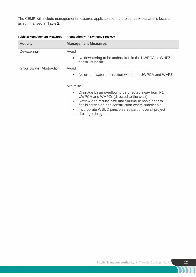
The CEMP will include management measures applicable to the project activities at this location,
as summarised in Table 2.
Table 2: Management Measures – Intersection with Kwinana Freeway
Activity Management Measures
Dewatering Avoid
No dewatering to be undertaken in the UWPCA or WHPZ to construct basin.
Groundwater Abstraction Avoid
No groundwater abstraction within the UWPCA and WHPZ.
Minimise
Drainage basin overflow to be directed away from P1 UWPCA and WHPZs (directed to the west).
Review and reduce size and volume of basin prior to finalising design and construction where practicable.
Incorporate WSUD principles as part of overall project drainage design.
13
4. Karel Avenue – Drainage Basins and Construction Area
4.1 Project Activities
4.1.1 Drainage Basins
Two stormwater drainage basins are proposed to be constructed within the Karel Avenue area,
north and south of the rail reserve to compensate for a 1 in a 100 year ARI rainfall event (Figure 2a
and 2b).
The two stormwater infiltration basins will be constructed within the project development envelope,
in proximity to Karel Avenue, referred to as north basin and south basin and were designed in
accordance with PTA (2018) as summarised in Table 3 and Figure 2a.
Table 3: Dimensions of North and South drainage basins
Basin Approximate volume (m3) Approximate area (m2) Approximate depth (mAHD)
North 4700 3500 2.4
South 2750 1650 2.5
4.1.2 Temporary Construction Area
A temporary construction area estimated to cover approximately 3.60 ha (Figure 2a) and located
adjacent Karel Avenue is required for project construction and track access. The temporary
construction area is approximately 800m north-east of the Water Corporation’s Production Bore
J400. 300mm of compacted, crushed limestone will be installed to form the hardstand at this site.
The site is owned by the PTA and earmarked for a future bus depot therefore it is intended to leave
the hardstand in place following completion of construction. . Activities not permitted to occur within
the Restricted Activity Zone (see Section 4.1.3) may occur within this limestone hardstand area, if
required.
The following activities are proposed for the temporary construction area:
Satellite office compound – self-contained site office, portable toilets, generator, security
fencing, laydown area, parking area and chemical storage area.
Installation of bunding around entire compound area for stormwater management.
Temporary storage of excavated soils.
Temporary hardstand area for construction materials – including steel, timber, railway
track, concrete sleepers, ballast, pipes, fencing materials, lighting and landscaping
materials.
Storage area – including sea containers, plant, equipment, tools, rubbish skip bins, etc.
Access tracks for machinery / plant to access construction area / railway reserve.
Storage and use of heavy equipment including trucks, front end loaders, excavators,
water trucks, graders and static and vibrating rollers, delivery trucks, concrete trucks and
pumps, concrete vibrators, cranes and power / hand tools.
Parking area – for vehicles and machinery.

Public Transport Authority Thornlie-Cockburn Link 14
Chemical storage area – bunded and self-contained storage area for chemicals, tools
and equipment. Limited hydrocarbon storage (no bulk storage) is anticipated at this site.
Refuelling area – a designated refuelling area will be demarcated onsite, with all fuel
supplied via a mobile fuel supply truck (i.e. no fuel storage onsite).
Drainage – installation of drainage for temporary stormwater retention onsite (e.g. swale
or bunded area).
4.1.3 Restricted Activity Zone
The south western portion of the Karel Avenue temporary construction area is sited within a P1
UWPCA. To comply with Government of Western Australia (2016) activity restrictions within the
UWPCA and WHPZs areas, this area will be designated a ‘Restricted Activity Zone’ (refer to Figure
2a). The following activities will be prohibited from occurring within the Restricted Activity Zone:
Storage of dangerous goods/chemicals.
Storage of mobile or permanent (>12 months) fuel storage tanks.
Installation/storage of underground chemical storage tanks (equal to or greater than 250
L).
Discharge of stormwater or groundwater.
Refuelling, repair or maintenance of vehicles.
Location of onsite wastewater treatment systems.
Use of landscaping materials that include organic matter rich soils and mulches.
Concrete wash down activities.
4.2 Potential Impacts
4.2.1 Dewatering
Dewatering is not required as part of construction of the temporary construction area or drainage
basins. There are no associated potential impacts to the site’s hydrology from dewatering.
4.2.2 Groundwater Abstraction
In accordance with Figure 11E of Golder (2019), groundwater can be abstracted within the eastern
portion of the construction area as well as east of Karel Avenue (within the development envelope).
An unacceptable impact risk from groundwater abstraction is present west of the construction area
to approximately Chainage 14000 (Figure 11E, Golder 2019).
4.2.3 Drainage Management
In accordance with Golder (2019), groundwater level is expected to increase by 1.5m following a 1
in 100 rainfall event. However as the approximate basin depth is 2.5 mAHD and groundwater level
is approximately 15mbgl, and the increase would be temporary, it is not expected that the drainage
basin would significantly impact the Banksia Woodlands located 60m east of the north basin and
90m east of the south basin (as shown in Figure 2b).
Both of the Karel Avenue basins would not result in a measureable increase in groundwater level
at the closest public drinking water bore located 850m west (Golder 2019). Following a 1 in 100
rainfall event, it is anticipated that the groundwater level would not increase by a measureable
amount due to the drainage basins.

15
4.2.4 Temporary Construction Area
Based on the activities proposed to be undertaken within the temporary construction area, the
following potential impacts may occur:
Contamination of soil, ground or surface water due to spills and or infiltration of run-off.
Dust emissions from vehicle operation on hardstand.
Flooding and/or ponding during high-rainfall events.
Littering within the site and surrounds due to uncontained/unmanaged waste storage
sites.
4.3 Management Measures
Management measures will be implemented in accordance with the Contractor’s overarching
CEMP as described in Section 3.3. The CEMP will include management measures applicable to
the project activities at this location, as summarised in Table 4.
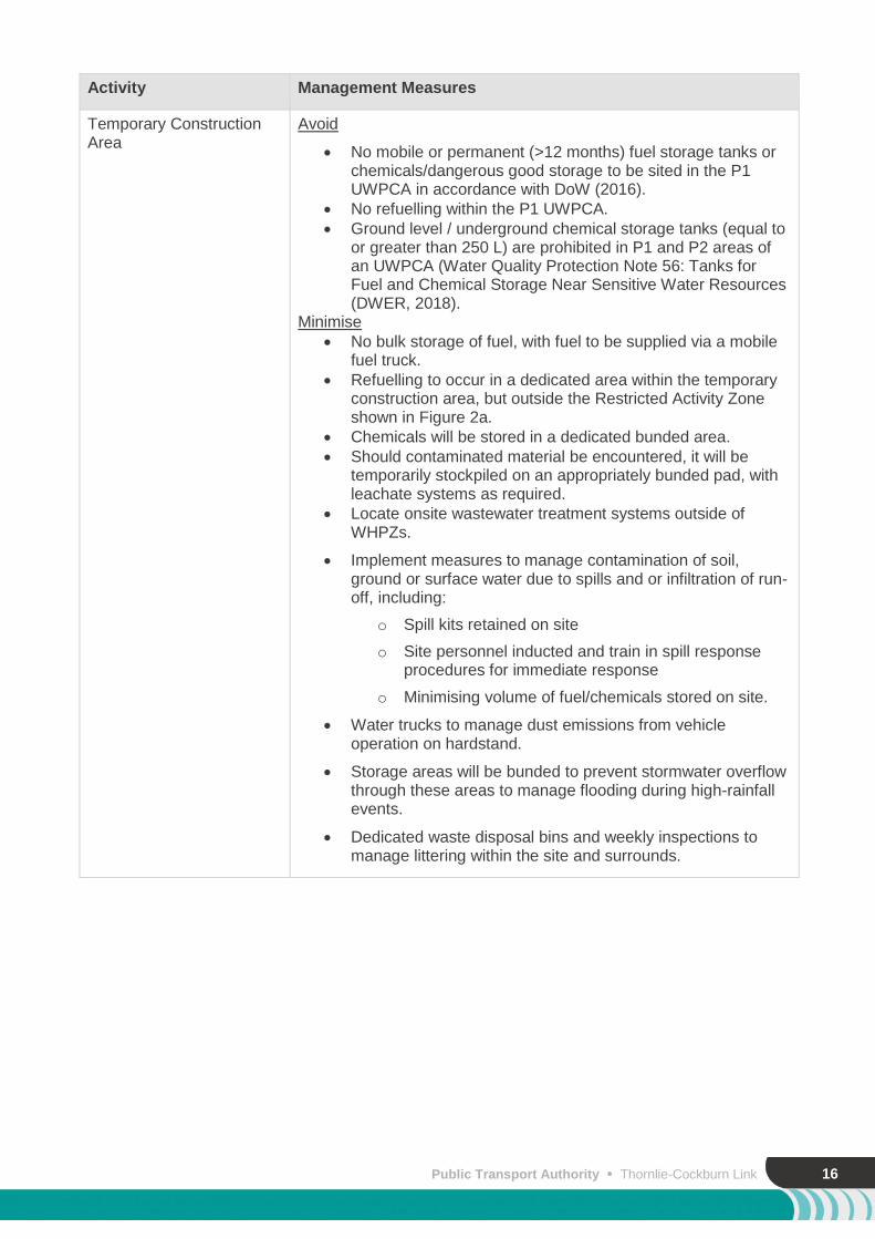
Table 4: Management Measures – Karel Avenue
Activity Management Measures
Dewatering Avoid
No dewatering required during drainage basin construction for this site.
Groundwater Abstraction Avoid
No groundwater abstraction in the south basin as per Golder (2019).
Minimise
Prohibited activities (e.g. abstraction, discharge) will not occur within the UWPCA and WHPZs Restricted Activity Zones.
Monitor production bores/monitoring wells adjacent to Banksia Woodlands TEC to assess drawdown trends and potential impacts (Figure 2b).
Drainage Management Avoid
Temporary stormwater control measures such as swales and bunding will be used around construction areas to prevent stormwater runoff entering adjacent areas.
Minimise
Where practicable, concentrate flows to the north basin as this location is a greater distance from the Banksia Woodlands.
Incorporate WSUD principles as part of overall project drainage designs.
Public Transport Authority Thornlie-Cockburn Link 16
Activity Management Measures
Temporary Construction Area
Avoid
No mobile or permanent (>12 months) fuel storage tanks or chemicals/dangerous good storage to be sited in the P1 UWPCA in accordance with DoW (2016).
No refuelling within the P1 UWPCA.
Ground level / underground chemical storage tanks (equal to or greater than 250 L) are prohibited in P1 and P2 areas of an UWPCA (Water Quality Protection Note 56: Tanks for Fuel and Chemical Storage Near Sensitive Water Resources (DWER, 2018).
Minimise
No bulk storage of fuel, with fuel to be supplied via a mobile fuel truck.
Refuelling to occur in a dedicated area within the temporary construction area, but outside the Restricted Activity Zone shown in Figure 2a.
Chemicals will be stored in a dedicated bunded area.
Should contaminated material be encountered, it will be temporarily stockpiled on an appropriately bunded pad, with leachate systems as required.
Locate onsite wastewater treatment systems outside of WHPZs.
Implement measures to manage contamination of soil, ground or surface water due to spills and or infiltration of run-off, including:
o Spill kits retained on site
o Site personnel inducted and train in spill response procedures for immediate response
o Minimising volume of fuel/chemicals stored on site.
Water trucks to manage dust emissions from vehicle operation on hardstand.
Storage areas will be bunded to prevent stormwater overflow through these areas to manage flooding during high-rainfall events.
Dedicated waste disposal bins and weekly inspections to manage littering within the site and surrounds.
17
5. Ranford Road Station 5.1 Project Activities
5.1.1 Construction of Ranford Road Station
The project includes construction of Ranford Road Station, a new railway station and bus
interchange with bus passenger transfer, drop-off area, walk on/cycle transfers, car parking bays
and a mixture of shelters and U-rails for bicycles. The layout of the Ranford Road Station is
currently in the concept design process with the final layout to be confirmed by the construction
contractor.
Specific works involved with the construction of the new station include:
A Bus interchange incorporating a minimum of 12 active bus bays (including 1 articulated
bus bay), six layover bays (including 1 articulated bus bay) and continuous roof cover
over bus stands
A Principle Shared Path (PSP) on southwestern edge/side of Ranford Road and Ranford
Road Bridge
A new PSP alongside southern edge of rail reserve (running under Ranford Road Bridge
alongside track)
150m long island platform located in the rail reserve cutting adjacent to the existing
freight line.
Station Entry Building and Concourse over the rail providing access to the Station from
the Bus Interchange and Station Carpark. The platform will be accessed via an overpass
with lifts, stairs and escalators.
Parking – 400 bays, with Park ‘n’ Ride bays, staff parking areas, passenger drop off
areas, universal access bays, universally accessible pedestrian pathways, motorcycle
parking, bicycle parking and taxi stands.
New Ranford Road Bridge to replace existing Ranford Road Bridge
Staff Toilet, Shower and Crib Room Facilities
Designated external bin store within Station carpark
Signalling, Electrical and Communications rooms and infrastructure
Incorporation of a Radio Monopole
5.1.2 Temporary Construction Area
A temporary construction area is also nominated to the north of the proposed Ranford Road
Station and rail reserve (Figure 3a). This temporary construction area is approximately 3.40 ha.
300mm of compacted, crushed limestone will be installed to form the hardstand at this site and
following construction of the project, the City of Canning will be consulted to agree whether the
crushed limestone hardstand should remain. The area will be treated to minimise erosion and dust
emissions.
Activities not permitted to occur within the Restricted Activity Zone may occur within this limestone
hardstand area, if required.
The following activities are proposed for this temporary construction area:

Public Transport Authority Thornlie-Cockburn Link 18
Satellite office compound – self-contained site office, portable toilets, generator, security
fencing, laydown area, parking area and chemical storage area.
Installation of bunding around entire compound area for stormwater management.
Temporary hardstand area for construction materials – including steel, timber, railway track,
concrete sleepers, ballast, pipes, fencing materials, lighting and landscaping materials.
Storage area – including sea containers, plant, equipment, tools, rubbish skip bins, etc.
Machinery hardstand areas – installation of hardstand areas to allow for construction
machinery and plant access to the rail reserve and proposed station.
Parking area – for vehicles and machinery.
Chemical storage area – bunded and self-contained storage area for chemicals, tools and
equipment. Limited hydrocarbon storage is anticipated at this site.
Refuelling area – a designated refuelling area will be demarcated onsite, with all fuel
supplied via a mobile fuel supply truck (i.e. no fuel storage onsite).
Drainage – installation of drainage for temporary stormwater retention onsite (e.g. swale or
bunded area).
Acid Sulfate Soils (ASS) treatment – should acid sulfate soils be encountered during
excavation works; the material may be temporarily transferred to an ASS treatment pad or
removed from site to a licensed landfill facility.
Stockpiling area for potentially contaminated excavated material, including installation of
leachate systems as required.
5.2 Potential Impacts
5.2.1 Dewatering
Due to depth to groundwater, dewatering is not anticipated to be required to construct Ranford
Road Station. Groundwater levels within the vicinity of the proposed Ranford Road Station average
approximately 21.2 mAHD. Station platforms and associated infrastructure are expected to be
constructed to a maximum depth of 27 mAHD, which is approximately 5.2 mAHD above the
groundwater level.
5.2.2 Groundwater Abstraction
As per Figure 11D of Golder (2019), there is an unacceptable impact risk and therefore
groundwater cannot be abstracted within the Ranford Road Station area, construction area or the
western portion of the rail reserve to approximately Chainage 10200 (Figure 11D, Golder 2019). A
manageable impact risk from groundwater abstraction is present in a small eastern area of Ranford
Road and surrounding Caladenia Grove Reserve, including Conservation Wetland UFI 6910
(Figure 3a).
5.2.3 Drainage Design and Management
As the final concept design of the station is yet to be confirmed, drainage basins have not been
designed or an indicative location provided for the Ranford Road Station and/or construction areas.
Following confirmation of the site layout by the construction contractor, drainage basins will be
designed and located in accordance with WSUD principles and in consideration of:
The location of the landfill mass
The location of wetlands (Figure 3a)
The location of Banksia Woodlands (Figure 3b).
Narrow Gauge Mainline Code of Practice Track and Civil Infrastructure Code of Practice
(PTA, 2018).
19
5.2.4 Contaminant Leaching
If required, piling into the landfill mass has the potential to enhance the vertical migration of
leachate. This is associated with the piling of deep foundations, which may be required to
penetrate the waste mass to transmit structure loadings to suitable strata beneath the waste
mass. Potential increases in the migration and/or generation of landfill leachate could produce
further impact to groundwater with risks posed to down-gradient aquatic ecosystems including the
Canning River and nearby wetlands.
Ground improvement construction activities such as loading and compression have the potential to
create a surge and therefore increase the rate of contaminants leaching into the underlying
groundwater. This impact however should be considered short-term until equalisation occurs, with
the long-term impacts of the station expected to reduce groundwater impacts. This is anticipated
due to the station hardstand restricting the pathway for rainfall infiltration. In addition, onsite
drainage will be directed to areas outside of the landfill mass and stormwater infiltrated at the site
is expected to be limited.
As part of the Ranford Road Detailed Site Investigation (GHD 2018), concentrations of aluminium
and per- and poly-fluoroalkyl substances (PFAS) were detected in the groundwater at the site,
which were indicative of local background (i.e. up-gradient) influences. The nature and extent of
PFAS in groundwater beyond the site (further down-gradient beyond the Bannister Road site) has
not been defined.
5.2.5 Temporary Construction Area
Based on the activities proposed to be undertaken within the temporary construction area, the
following potential impacts may occur:
Contamination of soil, ground or surface water due to spills and or infiltration of run-off.
Dust emissions from vehicle operation on hardstand
Flooding during high-rainfall events.
Littering within the site and surrounds due to uncontained/unmanaged waste storage
sites.
5.3 Management Measures
A Site Management Plan (SMP) will be prepared to manage contamination during the construction
of the Ranford Road Station. The SMP will identify contamination risks associated with excavation,
stockpiling and offsite disposal activities and specify management and mitigation measures
including management of ground gas.
Post construction, the SMP will be updated with specific risks and management measures
reflective of the final ground conditions and ongoing operational needs. All future management of
the Ranford Road Station will be undertaken in accordance with the SMP.
Two Mandatory Auditor’s Reports (MARs) are to be prepared for the Ranford Road Station site by
a DWER accredited Contaminated Sites Auditor (CSA). The PTA is proposing the first MAR to
include historical reporting up until, and including the Contractor’s CEMP and SMP. It would be
expected these would be reviewed and endorsed prior to the commencement of construction. A
second MAR is then proposed to include all reporting and investigations during construction,
including project closure and any ongoing site management requirements, following project
completion. The SMP will be supplied to DWER as part of the approvals process.

Public Transport Authority Thornlie-Cockburn Link 20
Management measures will be implemented in accordance with the Contractor’s overarching
CEMP as described in Section 3.3. The CEMP will include management measures applicable to
the project activities at this location, as summarised in Table 5.
Table 5: Management Measures – Ranford Road Station
Activity Management Measures
Dewatering Avoid
Dewatering is not anticipated to be required to construct the station or platforms.
Minimise
Conduct a review of dewatering requirements once detailed design has been completed and if required re-evaluate the potential impacts to surrounding vegetation and wetlands including Banksia woodlands.
Design options for the Ranford Road Station will be reviewed and refined to minimise any dewatering requirements, potentially reducing impacts to Wetlands UFI 6911, 6912 and UFI 13332.
Dewatering (if required) will be conducted in accordance with a Dewatering Management Plan.
Groundwater Abstraction Avoid
No groundwater abstraction bores within the Ranford Road Station site, the construction area or east to Chainage 10200 as per Golder (2019).
Minimise
Groundwater abstraction bores will not be located within “unacceptable” impact risk areas as per Golder (2019).
Where possible, limit groundwater abstraction to the west of the Ranford Road site area (areas depicted as “manageable” impact) (Golder 2019).
Drainage Management Avoid
Temporary stormwater control measures such as swales and bunding will be used around laydown areas to avoid stormwater runoff into adjacent areas.
No drainage basins to be located over landfill mass.
Minimise
Incorporation of WSUD principles as part of overall project drainage management.
Design options for the Ranford Road Station will be reviewed and refined, potentially reducing impacts to Wetlands UFI 6911, 6912 and UFI 13332.
Contamination / Stockpile Management
Avoid
No direct surface or groundwater discharge will be located over the landfill mass.

21
Activity Management Measures
Minimise
Ranford Road Station construction and post-construction works to be conducted in accordance with a site specific SMP and CEMP. The SMP will be endorsed by the CSA prior to construction commencement.
Should ASS be encountered during excavation works, the material will be transferred to an ASS treatment pad or removed from site to a licensed landfill and/or treatment facility.
Stockpile contaminated material on an appropriate bunded pad, with leachate systems as required.
Contaminated soil excavated for project works will be removed from the site and appropriately disposed of.
Monitor groundwater for the duration of construction to capture potential offsite migration of contaminated groundwater.
Temporary Construction Area
Minimise:
Ranford Road Station construction and post-construction works to be conducted in accordance with a site specific SMP and CEMP. The SMP will endorsed by the CSA prior to construction commencement and will include measures:
o Implement measures to manage contamination of soil, ground or surface water due to spills and or infiltration of run-off, including:
Spill kits retained on site
Site personnel inducted and train in spill response procedures for immediate response
Minimising volume of fuel/chemicals stored on site.
o Water trucks to manage dust emissions from vehicle operation on hardstand.
o Storage areas will be bunded to prevent stormwater overflow through these areas to manage flooding during high-rainfall events.
o Dedicated waste disposal bins and weekly inspections to manage littering within the site and surrounds.

Public Transport Authority Thornlie-Cockburn Link 22
6. Nicholson Road Station 6.1 Project Activities
The project includes construction of a new station to the east of Nicholson Road (Figure 4).
Nicholson Road Station comprises of a Bus Interchange and a Rail Station which integrates
pedestrian access into the existing suburban housing area east of Nicholson Road, the Tom
Bateman Recreation Reserve to the north and Canning Vale industrial area to the west.
The Station is to incorporate one island platform that is 150m in length and a Bus Interchange that
incorporates the following:
7 active bus bays (including 1 articulated bus bay)
3 layover bus bays (including 1 articulated bus bay)
Priority to bus movements between bus layover areas and bus stand areas.
1,000 car bays with a Short Term parking area that includes car Drop Off bays in close
proximity to the station entry and staff car parking bays.
Current station designs have indicated the bases of the platforms are anticipated to be 15.5mAHD,
with dewatering required to achieve a dry work environment to 14.5mAHD. Dewatering is therefore
required to construct the platforms and foundations.
6.2 Potential Impacts
6.2.1 Dewatering
Dewatering to construct the platform foundation is expected to be required for approximately six
months with rates estimated to be less than 10L/s (Figure 4). The dewatering effluent is proposed
to be reinfiltrated onsite via an infiltration basin or reinjection spears, pending volume and quality of
effluent. Pump tests will be conducted prior to dewatering to dictate the most suitable method of
effluent disposal.
In accordance with Golder (2019) and based on current conceptual designs of the platforms, it is
estimated that drawdown at the Conservation wetland (UFI 7446) 500m to the northeast will be
approximately 0.1m (Figure 4). Based on these results, mitigation measures are not proposed. If
dewatering requirements are increased, drawdown impacts will be reassessed and management
measures will be specified and included within the TCL Dewatering Management Plan and revised
CEMP.
6.2.2 Groundwater Abstraction
As per Figure 11B of Golder (2019), the Nicholson Road site area is “acceptable” for groundwater
abstraction, as well as approximately 300m east and west of the station, along the alignment.
6.2.3 Drainage Design
The current design of Nicholson Station includes six drainage basins; two basins located north, two
located midway and two located south, within the site area. The stormwater infiltration basins were
designed in accordance with PTA (2018) and are summarised in Table 6 and Figure 4.
23
Table 6: Dimensions of Nicholson Road Station Drainage Basins
Basin Approximate volume (m3) Approximate area (m2) Approximate depth (mAHD)
North 1 880 1700 0.9
North 2 200 330 0.9
Mid 1 680 1000 1.4
Mid 2 300 600 1.25
South 1 280 475 0.9
South 2 230 370 0.9
6.3 Management Measures
Management measures will be implemented in accordance with the Contractor’s overarching
CEMP as described in Section 3.3. The CEMP will include management measures applicable to
the project activities at this location, as summarised in Table 7.
Table 7: Management Measures – Nicholson Road Station
Activity Management Measures
Dewatering Minimise
Restrict the size of excavations to the minimum extent required to undertake the works.
Manage dewatering in accordance with a Dewatering Management Plan or Acid Sulfate Soil Dewatering Management Plan (if required).
Minimising the extent and duration of dewatering where practicable.
Maximise infiltration/re-injection and/or utilisation of discharge water from dewatering operations (if of acceptable water quality) for construction purposes in designated infiltration areas.
Divert dewatering effluent to a settlement pond and/or re-injection or re-infiltration in an adjacent area.
Conduct dewatering, water quality and level monitoring in accordance with the Dewatering Management Plan.
Trigger levels for monitoring potential groundwater drawdown impact (i.e. level not allowed to be lowered beyond) will be determined following baseline monitoring and taking into account natural seasonal variation.
ASS Investigations will be carried out in the location of proposed dewatering.
Should ASS be encountered during excavation works, the material will be temporarily transferred to an ASS treatment pad or removed from site to a licensed landfill facility.
Groundwater abstraction Avoid
No groundwater abstraction east of Nicholson Road as per Golder (2019).

Public Transport Authority Thornlie-Cockburn Link 24
Activity Management Measures
Minimise
Locate groundwater abstraction points in the western half of the station or west along the alignment up to approximately Chainage 5600 as per Golder (2019).
Drainage management Minimise
Incorporate WSUD principles as part of overall project drainage designs.
Construction area – storage of materials and stockpiling
Minimise
Refuelling will occur in a dedicated area within the temporary construction area.
Store chemicals in a dedicated bunded area.
Should contaminated material be encountered, it will be temporarily stockpiled on an appropriate bunded pad, with leachate systems as required.
Locate onsite wastewater treatment systems outside of WHPZs.
Ground level / underground chemical storage tanks (equal to or greater than 250 L) are prohibited in P1 and P2 areas of an UWPCA.
Above ground chemical storage tanks (equal to or greater than 250 L capacity) are prohibited in P1 and P2 WHPZs of an UWPCA (DoW, 2016).
25
7. Tom Bateman Reserve Temporary Construction Area and Pedestrian Footbridge
7.1 Project Activities
7.1.1 Temporary Construction Area
A temporary construction area, approximately 0.53 ha, is required within Tom Bateman Reserve
for storage of construction materials, as well as to provide access to the rail reserve (Figure 5a and
Figure 5b).
The following activities will be undertaken in this temporary construction area:
Limestone hardstand area (crushed limestone) for laydown of construction materials –
including steel, timber, rail track, ballast, concrete sleepers, pipes, fencing materials,
lighting and landscaping materials.
Satellite office compound – self-contained site office, portable toilets, generator, security
fencing and parking area.
Stockpiling area – temporary stockpiling of fill materials.
Truck unloading facility – access for trucks to unload construction materials.
Access track – access track to the railway corridor, approximately 10 m in width, noting
that this track will remain following completion of construction for railway and City of
Gosnells access purposes.
Drainage – installation of drainage for temporary retention onsite (e.g. swale or bunded
area). Drainage will be directed away from wetland areas and infiltrated onsite.
ASS treatment – should acid sulfate soils be encountered during excavation works; the
material will be temporarily transferred to an ASS treatment pad or removed from site to a
licensed landfill facility. The ASS treatment pad will consist of a bunded limestone pad
(minimum 300mm thick) with a leachate collection system to prevent runoff of untreated
material.
The temporary construction area has been positioned outside of wetland areas (Figure 5b). See
Plate 1 for site photos of the location of the proposed construction area. The site consists of a
weedy grassed area that has been previously disturbed, with remnant patches of mature trees.
The majority of the mature trees are Melaleuca preissiana and M. rhaphiophylla.
Plate 1: Site photos of area proposed for Tom Bateman Reserve temporary construction area

Public Transport Authority Thornlie-Cockburn Link 26
The main purpose of the temporary construction area at this location is to provide access to the
northern side of the rail reserve and the laydown of construction materials. The temporary
construction area may be used for temporary storage of surplus materials, or as overflow areas for
parking of vehicles, machinery or storage of equipment.
300mm of compacted, crushed limestone will be installed to form the limestone hardstand area at
this site, as depicted in Figure 5b. Activities not permitted to occur within the Restricted Activity
Zone may occur within this limestone hardstand area, where required.
The crushed limestone access track will remain permanently following construction. The track will
be used as an emergency access track for PTA to the rail corridor and by the City of Gosnells for
maintenance access (Figure 5b). The limestone access track will remain within the boundary of
CCW UFI 7446 and intersects approximately 0.08 ha.
In addition, prior to the completion of construction of the project, the PTA will consult with the City
of Gosnells to determine whether the crushed limestone hardstand area needs to be retained
consistent with any future development plans for the site. If the hardstand area is not required by
the City, the PTA will remove the hardstand materials to allow for natural regrowth and will stabilise
the area.
7.1.2 Native Vegetation Retention Area
A Native Vegetation Retention Area will be established within the Tom Bateman Reserve for the
purpose of retaining patches of native vegetation. The PTA will avoid clearing of native vegetation
within these areas by implementing controls during construction. The Native Vegetation Retention
Area will be managed as follows:
Identification on project mapping and demarcation in the field – shown on Figure 5a
Each patch will be demarcated with fencing/flagging as per the boundaries shown in
Figure 5a and Figure 5b. The majority of the patches at this location are Melaleuca
preissiana and M. rhaphiophylla.
Weekly inspections of this Native Vegetation Retention Area will be conducted to ensure
all flagged demarcated vegetated areas are retained.
7.1.3 Pedestrian Footbridge – Cameron Street to Elliot Place
As part of the project, the existing pedestrian level crossing between Cameron Street and Elliot
Place in Thornlie will be replaced and grade-separated with the construction of a pedestrian
footbridge (Figure 5).
The preferred construction methodology for the footbridge is either screw or bored piles which
would minimise requirements for dewatering. However, the footbridge may be constructed using
pad footings which may require a small quantity of dewatering. The foundations will have a
relatively small footprint. See Plate 2 for a site photo of the location of the proposed footbridge.

27
Plate 2: Location of proposed Pedestrian Footbridge between Cameron Street to Elliot Place
7.2 Potential Impacts
7.2.1 Dewatering
Construction of the pad footings of the pedestrian footbridge may require a small quantity of
dewatering. The expected duration of dewatering is two months at a rate of <10 L/s. The current
(summer 2019) depth to groundwater at this location is approximately 1.72 to 3.29 mbgl.
Dewatering has the potential to impact the Conservation Category wetland (UFI 7446) located
approximately 150 m south-west of the footings of the pedestrian footbridge (Figure 5a). This
wetland is surrounded by Multiple Use wetland UFI 13621. The footbridge is also located on the
northern boundary of Bush Forever Site 456 (Nicholson Road Bushland).
As dewatering will be minimal and of short duration, the likelihood of any associated groundwater
drawdown impacting the nearby wetland is considered low. The drawdown at the Conservation
Category wetland (UFI 7446) which is 150m south-west from the proposed footings is likely to be
approximately 0.1m (Golder 2019). However, based on design levels and groundwater levels

Public Transport Authority Thornlie-Cockburn Link 28
measured in the area, this is considered a conservative estimate and dewatering requirements are
likely to be limited and considered to be manageable through the Dewatering Management Plan.
7.2.2 Groundwater Abstraction
As per Figure 11B of Golder (2019), groundwater abstraction in the area surrounding the
pedestrian bridge has been classified as a “manageable” impact risk. An “unacceptable” impact
risk from groundwater abstraction is present immediately west of the site area, in alignment with
the Conservation category wetland UFI 7446.
7.2.3 Drainage Management
No major drainage infrastructure is proposed to be installed in the vicinity of the Tom Bateman
Reserve construction area or the Cameron Street/Elliot Place pedestrian footbridge. It should be
noted that the existing drain into the constructed wetland is being relocated. The outlet pipe will still
outfall at the current location, only the pipes are being relocated to allow for construction of the
pedestrian bridge.
Any temporary drainage for the construction area will utilise existing drainage infrastructure.
Sediment controls such as bunds and settlement ponds will be utilised if required to ensure no
offsite discharge of sediment.
7.2.4 Temporary Construction Area
The temporary construction area within Tom Bateman Reserve will be used for temporary storage
of materials and stockpiling. Storage of chemicals within the limestone hardstand area at this
location has the potential to result in pollution of the adjacent wetland area, including Conservation
Category wetland UFI 7446.
In addition, should contamination be encountered during construction it may be temporarily
stockpiled within the limestone hardstand and/or temporary construction area, which has the
potential to result in leachate contaminating the groundwater and impacting the adjacent wetland
area, including Conservation Category wetland UFI 7446.
Based on the activities proposed to be undertaken within the temporary construction area, the
following potential impacts may occur:
Contamination of soil, ground or surface water due to spills and/or infiltration of run-off,
including from the stockpile of contaminated soil.
Dust emissions from vehicle operation on hardstand
Flooding during high-rainfall events.
Littering within the site and surrounds due to uncontained/unmanaged waste storage
sites.
7.2.5 Restricted Activity Zone
A 50 m buffer from UFI 7446 within the Tom Bateman temporary construction area has been
designated as a Restricted Activity Zone (refer to Figure 5b). The following activities are prohibited
from occurring within the Restricted Activity Zone:
Storage of dangerous goods/chemicals.
Storage of mobile or permanent (>12 months) fuel storage tanks.
Installation/storage of underground chemical storage tanks (equal to or greater than 250
L).
Discharge of stormwater or groundwater.
29
Refuelling, repair or maintenance of vehicles.
Location of onsite wastewater treatment systems.
Use or stockpiling of landscaping materials that include organic matter rich soils and
mulches.
Concrete wash down activities.
Storage of contaminated soil.
7.3 Management Measures
Management measures will be implemented in accordance with the Contractor’s overarching
CEMP as described in Section 3.3. The CEMP will include management measures applicable to
the project activities at this location, as summarised in Table 8.
Table 8: Management Measures: Tom Bateman Reserve Construction Area and Pedestrian Footbridge
Activity Management Measures
Dewatering Avoid
No dewatering within a Conservation Category wetland.
Where practicable dewatering will be avoided in the construction of the pedestrian bridge (depending on the construction methodology).
Minimise
Dewatering will be managed in accordance with a Dewatering Management Plan (if required).
Where dewatering cannot be avoided, minimise the extent and duration of dewatering where practicable.
Maximise infiltration/re-injection and/or utilisation of discharge water from dewatering operations (if of acceptable water quality) for construction purposes in designated infiltration areas.
Divert dewatering effluent to a settlement pond or structure, monitor water quality and level (via piezometer(s)) and re-inject or re-infiltrate in an adjacent area.
If re-injection wells are used, these will be placed outside of the Conservation Category wetland UFI 7446.
Obtain baseline water quality data from Conservation Category wetland UFI 7446 before the commencement of dewatering operations (which may involve more than one monitoring event to ensure the data are representative and to capture seasonal variations).
Measure standing water levels within Conservation Category wetland UFI 7446 before the commencement of dewatering operations.
Trigger levels for monitoring potential groundwater drawdown impact (i.e. level not allowed to be lowered beyond) will be determined following baseline monitoring and taking into account natural seasonal variation.
ASS Investigations will be carried out in the location of proposed dewatering.
Should ASS be encountered during excavation works, the material will be temporarily transferred to an ASS treatment pad for the TCL Proposal or removed from site to a licensed landfill facility.

Public Transport Authority Thornlie-Cockburn Link 30
Activity Management Measures
Groundwater Abstraction
Avoid
No groundwater abstraction west of the pedestrian bridge site (immediately south of UFI 7446) area as per Golder (2019).
Temporary Construction Area – storage of materials and stockpiling
Avoid
No bulk fuel storage tanks or chemicals/dangerous good storage will be sited in Conservation Category wetland 7446.
Temporary stormwater control measures such as swales and bunding will be used around the laydown area to avoid stormwater runoff into adjacent areas.
Minimise
There will be no bulk storage of fuel, with fuel supplied via a mobile fuel truck.
Refuelling will occur in a dedicated area within the temporary construction area.
Chemicals will be stored in a dedicated bunded area to ensure that pollutants are not washed into adjacent areas during rainfall events.
Should contaminated material be encountered, it will be temporarily stockpiled on an appropriate bunded pad, with leachate systems as required.
Implement measures to manage contamination of soil, ground or surface water due to spills and or infiltration of run-off, including:
o Spill kits retained on site
o Site personnel inducted and train in spill response procedures for immediate response
o Minimising volume of fuel/chemicals stored on site.
Water trucks to manage dust emissions from vehicle operation on hardstand.
Storage areas will be bunded to prevent stormwater overflow through these areas to manage flooding during high-rainfall events.
Dedicated waste disposal bins and weekly inspections to manage littering within the site and surrounds.
31
8. Thornlie Station 8.1 Project Activities
8.1.1 Thornlie Station
The existing Thornlie Station will be modified to accommodate six–car trains and will also include
upgrades to existing infrastructure to allow the station to function as a ‘through’ station on the TCL
to the existing Cockburn Central Station. Specific works as part of the upgrade include:
New pedestrian concourse to connect the platforms with new vertical transport (lifts and
stairs) and roofing;
Extending existing platforms from 100m to 150m to accommodate a six railcar set;
Modification of existing shared paths;
Provision of new staff amenities (showers and toilets);
Electrical and communications infrastructure upgrades; and,
Replacement and upgrade of existing electrical substation.
8.1.2 Internal Stormwater Infiltration Basin
A stormwater infiltration basin will be constructed within the rail corridor, south-west of the station
as shown in Figure 6. The proposed basin will be 2.2 mAHD deep, with a surface area of 1,750m2
and a storage volume of 1,490m3.
8.2 Potential Impacts
8.2.1 Drainage Management
The Thornlie Station is surrounded by developed residential and commercial properties with
access via Spencer Road. The nearest environmentally sensitive area is Resource Enhancement
wetland UFI 7499, approximately 280 m north-east of the station and 430 m north-east of the
proposed infiltration basin (Figure 6).
The majority of the stormwater in the vicinity of the Thornlie Station will be directed to the infiltration
basin, and no hydrological impacts are expected to Resource Enhancement wetland UFI 7499 due
to the distance.
8.2.2 Dewatering
No dewatering is anticipated to be required to modify Thornlie Station, and therefore there are no
associated potential dewatering impacts.
8.2.3 Groundwater Abstraction
In accordance with Figure 11B of Golder (2019), groundwater abstraction in the area surrounding
Thornlie Station has been classified as an “acceptable” impact risk. Immediately west and east of
the station are also “acceptable” risk areas.
8.3 Management Measures
Management measures will be implemented in accordance with the Contractor’s overarching
CEMP as described in Section 3.3. No specific environmental management measures have been
developed for the modification of Thornlie Station as the associated works are highly unlikely to
impact nearby environmental values.

Public Transport Authority Thornlie-Cockburn Link 32
9. Canning River Rail Bridge Duplication and Construction Area
9.1 Project Activities
9.1.1 Canning River Rail Bridge Duplication
The existing passenger rail bridge over the Canning River is proposed to be duplicated.
Construction of the rail bridge involves installation of foundations for the bridge piers in alignment
with the piers of the existing bridge (Figure 7a). Detailed design may move the alignment of piers
however piers will not be located within the river channel. Following this, footings will be
constructed on the foundations and then bridge spans installed in between.
There are three options for the construction of the bridge duplication, with the anticipated method
being incremental launch. Incremental launch involves the structure being built in segments in a
casting yard, and put together by working from one end of the bridge to the other. The bridge
foundation piles are expected to be installed via driven piles however there is a chance that bored
piles may also be used, with neither methods requiring dewatering. Minor dewatering will be
required for the construction of pile caps which hold the piles for each pier together.
The incremental launch method to place bridge spans onto the piers involves pushing a span from
one side onto the pier columns. Alternatively, the bridge spans may be lifted into place by cranes.
See Plate 3 for a site photo of the location of the existing Canning River Rail Bridge and location of
duplication.
Plate 3: Site photos showing location of rail bridge duplication.

33
9.1.2 Temporary Construction Areas
Two temporary construction areas are required adjacent the Canning River for construction of the
Canning River Rail Bridge Duplication (Figure 7a). The temporary construction areas are located
on the north and south sides of the Canning River, with the northern temporary construction area
identified as the main construction site.
The following activities will be undertaken in the northern temporary construction area:
Satellite office compound – self-contained site office, portable toilets, generator, security
fencing, laydown area, parking area and chemical storage area. Installation of bunding
around entire compound area for stormwater management.
Temporary hardstand area for construction materials – including steel, timber, railway track,
ballast, pipes, fencing materials, lighting and landscaping materials.
Rail bridge construction – including earthworks, concrete pouring, bridge installation.
Storage area – including sea containers, plant, equipment, tools, rubbish skip bins, etc.
Access track – access for construction plant and vehicles from Rimmer Lane, including
access to the Canning River Rail Bridge Duplication site. Approximately 10 m wide.
Machinery hardstand areas – installation of hardstand areas on the northern and southern
sides of the Canning River to allow for construction machinery and plant access to the rail
bridge duplication area. Two pads will be installed on either side of the river for crane pads.
Parking area – for vehicles and machinery (outside of the Canning River floodway and flood
fringe floodplain (1 in 100 (1%) annual exceedence probability (AEP)).
Chemical storage area – bunded and self-contained storage area for chemicals, tools and
equipment. Limited hydrocarbon storage is anticipated at this site.
Re-fuelling area – a designated refuelling area will be demarcated onsite, with all fuel
supplied via a mobile fuel supply truck (i.e. no bulk fuel storage onsite).
Drainage – installation of drainage for temporary stormwater retention onsite (e.g. swale or
bunded area).
ASS treatment – should acid sulfate soils be encountered during excavation works; the
material will be temporarily transferred to an ASS treatment pad for the TCL Proposal or
removed from site to a licensed landfill facility.
Plate 4: Site photo showing the northern extent proposed location of construction area north of Canning River
(adjacent to Rimmer Lane).

Public Transport Authority Thornlie-Cockburn Link 34
The limestone hardstand areas, as indicated in Figure 7a have been located outside of the
Canning River floodway and flood fringe (1 in 100 AEP) and 50 m wetland buffer. Activities
restricted within the Restricted Activity Zone may occur within the limestone hardstand area, where
required. See Plate 4 for a site photo of the location of the proposed construction area north of
Canning River. 300mm of compacted, crushed limestone will be installed to form the hardstand
areas at this site and following construction of the project, as part of demobilisation, the PTA will
remove the crushed limestone hardstand. The area will be stabilised and returned to
commensurate pre-project condition and with permission from the landowner, will be revegetated
in consultation with the DBCA.
9.1.3 Native Vegetation Retention Area
A Native Vegetation Retention Area will be established south of Canning River for the purpose of
retaining patches of native vegetation (Figure 7b). The PTA will avoid clearing of native vegetation
within these areas by implementing controls during construction. The Native Vegetation Retention
Area will be managed as follows:
Identification on project mapping and demarcation in the field – shown on Figure 7b
Each vegetation patch will be flagged for retention. There are 14 potential Black
Cockatoo breeding trees within this area, as well as a number of other smaller mature
trees.
The main purpose of the construction area at this location is to provide access to the
southern side of the railway including access for the construction of the duplication of Rail
Bridge over Canning River. Storage of materials will be located outside of the Native
Vegetation Retention Area.
Weekly inspections of this Native Vegetation Retention Area will be conducted to ensure
all demarcated vegetated areas are retained.
See Plate 5 for a site photo of the location of the proposed construction area south of Canning
River.
35
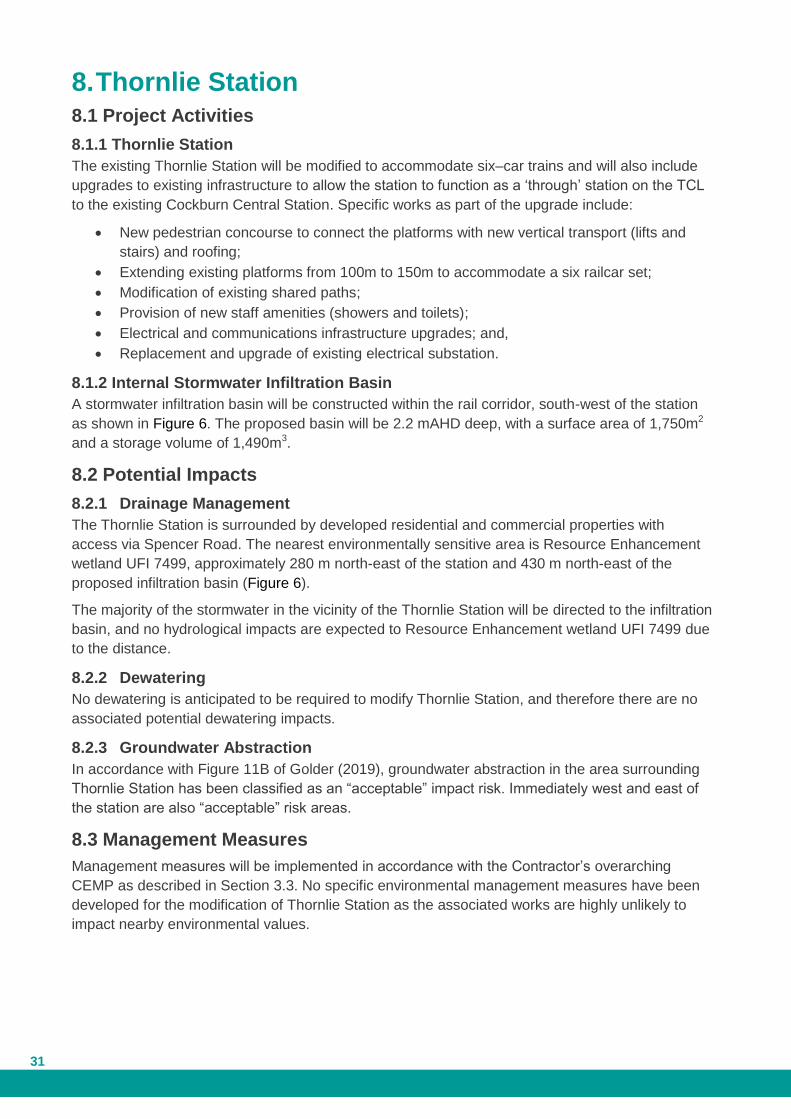
Plate 5: Site photo showing proposed location of construction area south of Canning River, with mature
trees to be retained in the Native Vegetation Retention Area.
Following construction of the project, the PTA will remove hardstand materials from the
construction areas (e.g. crushed limestone) and stabilise the areas. At the northern construction
area, the PTA will also revegetate the impacted portion with suitable flora species. Revegetation
plans will be determined in consultation with the DBCA and DWER, noting the area is within a
Bush Forever Site, the Canning River floodway and flood fringe (1 in 100 AEP) and the Swan
Canning Development Control Area.
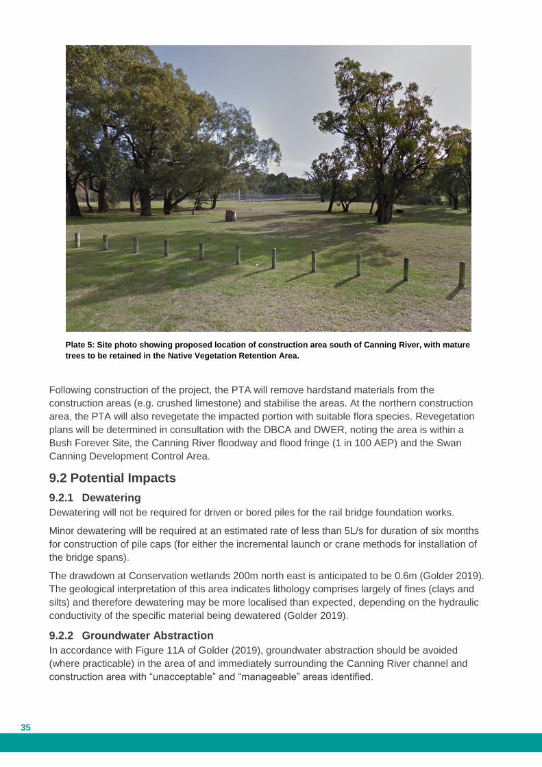
9.2 Potential Impacts
9.2.1 Dewatering
Dewatering will not be required for driven or bored piles for the rail bridge foundation works.
Minor dewatering will be required at an estimated rate of less than 5L/s for duration of six months
for construction of pile caps (for either the incremental launch or crane methods for installation of
the bridge spans).
The drawdown at Conservation wetlands 200m north east is anticipated to be 0.6m (Golder 2019).
The geological interpretation of this area indicates lithology comprises largely of fines (clays and
silts) and therefore dewatering may be more localised than expected, depending on the hydraulic
conductivity of the specific material being dewatered (Golder 2019).
9.2.2 Groundwater Abstraction
In accordance with Figure 11A of Golder (2019), groundwater abstraction should be avoided
(where practicable) in the area of and immediately surrounding the Canning River channel and
construction area with “unacceptable” and “manageable” areas identified.

Public Transport Authority Thornlie-Cockburn Link 36
No groundwater abstraction bores are to occur within areas of Canning River site area depicted as
“unacceptable”.
9.2.3 Drainage Management
No major drainage infrastructure is proposed to be installed in the vicinity of the Canning River Rail
Bridge Duplication or adjacent construction area. The drainage outfall on the southern side of the
river will be relocated to allow construction.
9.2.4 Temporary Construction Area
Based on the activities proposed to be undertaken within the temporary construction area, the
following potential impacts may occur:
Contamination of soil, ground or surface water due to spills and or infiltration of run-off.
Dust emissions from vehicle operation on hardstand
Flooding during high-rainfall events.
Littering within the site and surrounds due to uncontained/unmanaged waste storage
sites.
9.2.5 Restricted Activity Zone
A portion of the Canning River construction area (outside the rail corridor and excluding the
limestone hardstand area depicted in Figure 7b) will be categorised as a Restricted Activity Zone.
This incorporates a 50 m buffer from Conservation and Resource Enhancement wetlands. The
following activities are prohibited from occurring within the Restricted Activity Zone:
Storage of dangerous goods/chemicals.
Storage of mobile or permanent (>12 months) fuel storage tanks.
Installation/storage of underground chemical storage tanks (equal to or greater than 250
L).
Discharge of stormwater or groundwater.
Refuelling, repair or maintenance of vehicles.
Location of onsite wastewater treatment systems.
Use or stockpiling of landscaping materials that include organic matter rich soils and
mulches.
Concrete wash down activities.
Stockpile of ASS or contaminated soil.
9.3 Management Measures
Management measures will be implemented in accordance with the Contractor’s overarching
CEMP as described in Section 3.3. Works within the Swan Canning Development Control Area will
require a permit under Regulation 29 of the Swan and Canning Rivers Management Regulations
2007. The construction contractor will be required to obtain the permit and ensure their works are
undertaken in accordance with it. Management measures for the project activities at this location
are outlined in Table 9.
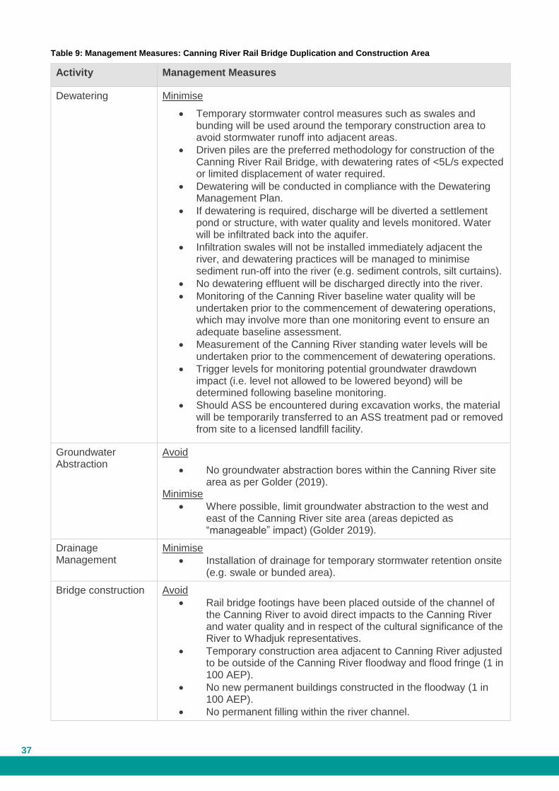
37
Table 9: Management Measures: Canning River Rail Bridge Duplication and Construction Area
Activity Management Measures
Dewatering Minimise
Temporary stormwater control measures such as swales and bunding will be used around the temporary construction area to avoid stormwater runoff into adjacent areas.
Driven piles are the preferred methodology for construction of the Canning River Rail Bridge, with dewatering rates of <5L/s expected or limited displacement of water required.
Dewatering will be conducted in compliance with the Dewatering Management Plan.
If dewatering is required, discharge will be diverted a settlement pond or structure, with water quality and levels monitored. Water will be infiltrated back into the aquifer.
Infiltration swales will not be installed immediately adjacent the river, and dewatering practices will be managed to minimise sediment run-off into the river (e.g. sediment controls, silt curtains).
No dewatering effluent will be discharged directly into the river.
Monitoring of the Canning River baseline water quality will be undertaken prior to the commencement of dewatering operations, which may involve more than one monitoring event to ensure an adequate baseline assessment.
Measurement of the Canning River standing water levels will be undertaken prior to the commencement of dewatering operations.
Trigger levels for monitoring potential groundwater drawdown impact (i.e. level not allowed to be lowered beyond) will be determined following baseline monitoring.
Should ASS be encountered during excavation works, the material will be temporarily transferred to an ASS treatment pad or removed from site to a licensed landfill facility.
Groundwater Abstraction
Avoid
No groundwater abstraction bores within the Canning River site area as per Golder (2019).
Minimise
Where possible, limit groundwater abstraction to the west and east of the Canning River site area (areas depicted as “manageable” impact) (Golder 2019).
Drainage Management
Minimise
Installation of drainage for temporary stormwater retention onsite (e.g. swale or bunded area).
Bridge construction Avoid
Rail bridge footings have been placed outside of the channel of the Canning River to avoid direct impacts to the Canning River and water quality and in respect of the cultural significance of the River to Whadjuk representatives.
Temporary construction area adjacent to Canning River adjusted to be outside of the Canning River floodway and flood fringe (1 in 100 AEP).
No new permanent buildings constructed in the floodway (1 in 100 AEP).
No permanent filling within the river channel.

Public Transport Authority Thornlie-Cockburn Link 38
Activity Management Measures
Mobile fuel storage tanks will not be sited in the floodway (1 in 100 AEP) as it may not be possible to obtain 2m separation distance to groundwater.
No bulk fuel storage tanks located in the floodway (1 in 100 AEP).
No storage of chemicals or dangerous goods, even if appropriately bunded, in the floodway (1 in 100 AEP).
No stockpiles of potentially contaminated soil located in the floodway (1 in 100 AEP).
Minimise
The new Canning River Rail Bridge footings/pillars will not be placed within the river channel.
Final design will include a hydraulic analysis to determine appropriate afflux criteria in consultation with DWER.
Based on the above restrictions and proposed placement of footings/pillars, the risk of obstructing flows during major flood events is considered low, and therefore no significant impacts to the hydrological processes of the Canning River flood regime are expected.
Silt curtains and protection bunds to be installed to prevent discharges to river.
Rehabilitate
Following construction of the bridge, the PTA will remove hardstand materials from the river riparian zone and rehabilitate the impacted area of the river fringe.
Rehabilitation works will include stabilisation of the river bank and revegetation with suitable flora species.
An Indicative Riverbank Rehabilitation Zone is shown in Figure 7a. This Zone is an approximate 20 m buffer of the Canning River waterway and 100m in length.
The PTA will remove hardstand materials from the construction area (e.g. crushed limestone), stabilise and revegetate the impacted portion with suitable flora species, excluding the southern temporary construction area.
Rehabilitation plans will be determined in consultation with the DBCA and DWER, noting the area is within a Bush Forever Site, the Canning River floodway and flood fringe (1 in 100 AEP)and the Swan River Trust Development Control Area.
Temporary Construction Area
Minimise:
Implement measures to manage contamination of soil, ground or surface water due to spills and or infiltration of run-off, including:
o Spill kits retained on site
o Site personnel inducted and train in spill response procedures for immediate response
o Minimising volume of fuel/chemicals stored on site.
Water trucks to manage dust emissions from vehicle operation on hardstand.
Storage areas will be bunded to prevent stormwater overflow through these areas to manage flooding during high-rainfall

39
Activity Management Measures
events.
Dedicated waste disposal bins and weekly inspections to manage littering within the site and surrounds.
Public Transport Authority Thornlie-Cockburn Link 40
10 References
Aurora Environmental (2019a) Thornlie-Cockburn Link – Referral Information with Additional
Information Report. Version 5. 16 May 2019
Aurora (2019b) Thornlie-Cockburn Link – Construction Environmental Management Plan. Version
4, May 2019
DWER (2018). Water Quality Protection Note 56: Tanks for Fuel and Chemical Storage Near
Sensitive Water Resources. Department of Water and Environmental Regulation (DWER), Perth
WA.
GHD (2018) Ranford Road Metronet Detailed Site Investigation. GHD Perth.
Golder (2019) Thornlie-Cockburn Link - Preliminary Hydrogeological Assessment. June 2019
Government of Western Australia (2019). Public Drinking Water Source Areas (DWER-033)
accessed on 21 June 2019 from https://catalogue.data.wa.gov.au/dataset/public-drinking-water-
source-areas
Government of Western Australia (2016). Land use compatibility tables for public drinking water
source areas. April 2016. Department of Water, Perth WA
PTA (2018). Narrow Gauge Mainline Code of Practice Track and Civil Infrastructure Code of
Practice. Public Transport Authority (PTA), Perth WA.
41
Figures
Figure 1a Kwinana Freeway
Figure 1b Kwinana Freeway – TEC/PECs
Figure 2a East of Karel Avenue
Figure 2b East of Karel Avenue – TEC/PECs
Figure 3a Ranford Road Station – Wetlands
Figure 3b Ranford Road Station – TEC/PECs
Figure 4 Nicholson Road Station
Figure 5a Tom Bateman Construction Area and Pedestrian Footbridge
Figure 5b Tom Bateman Construction Area and Pedestrian Footbridge – Further Detail
Figure 6 Thornlie Station
Figure 7a Canning River Rail Bridge Duplication and Construction Area
Figure 7b Canning River Rail Bridge Duplication and Construction Area – Wetlands

@A
6650
J400
Figure 1a - Intersection with Kwinana Freeway
Document Path: Y:\ENVIRONMENTAL\Sam\05_ThornlieCockburnLink\02_MXDs\02_EnvironmentalAssessment\Water_Memo\Figure1a_Intersection_KFwy_A4P.mxd
Date Printed: 26/06/2019Created By: Rob McGregor ¯
Base Data: Nearmap 2018, Sources: Esri, HERE, Garmin, USGS, Intermap, INCREMENT P, NRCan, Esri Japan, METI, Esri China (Hong Kong), Esri Korea, Esri (Thailand), NGCC, (c) OpenStreetMap contributors, and the GIS User CommunityEsri, HERE, Garmin, (c) OpenStreetMap contributors, and the GIS user community
1:8,000Scale
0 125 25062.5 m
LegendDevelopment EnvelopeIndicative Drainage Basins
@A Water Corporation Production BoreWellhead Protection Zone
WetlandsConservationMultiple UseResource Enhancement
Jandakot Underground WaterPollution Control Area (UWPCA)Priority
P1P2P3
388
Figure 1b - Intersection with Kwinana Freeway – TEC/PECs
Document Path: Y:\ENVIRONMENTAL\Sam\05_ThornlieCockburnLink\02_MXDs\02_EnvironmentalAssessment\Water_Memo\Figure1b_Intersection_KFwy_TECPEC_A4P.mxd
Date Printed: 26/06/2019Created By: Rob McGregor ¯
Base Data: Nearmap 2018, Sources: Esri, HERE, Garmin, USGS, Intermap, INCREMENT P, NRCan, Esri Japan, METI, Esri China (Hong Kong), Esri Korea, Esri (Thailand), NGCC, (c) OpenStreetMap contributors, and the GIS User CommunityEsri, HERE, Garmin, (c) OpenStreetMap contributors, and the GIS user community
1:8,000Scale
0 125 25062.5 m
LegendDevelopment EnvelopeBush Forever (Site Number Labelled)Indicative Drainage Basins
Banksia Woodlands of the Swan Coastal Plain TECLow lying Banksia attenuata woodlands orshrublands - SCP21c PEC

@A
6650
J400
LegendDevelopment EnvelopeIndicative Drainage Basins
@A Water Corporation Production BoreWellhead Protection ZoneLimestone Hardstand AreaRestricted Activity ZoneTemporary Construction Area
WetlandsConservationMultiple UseResource Enhancement
Jandakot Underground Water PollutionControl Area (UWPCA)Priority
P1P2P3
Figure 2a - Karel Avenue
Document Path: Y:\ENVIRONMENTAL\Sam\05_ThornlieCockburnLink\02_MXDs\02_EnvironmentalAssessment\Water_Memo\Figure2a_WaterCorp_Bore_A4P.mxd
Date Printed: 26/06/2019Created By: Rob McGregor ¯
Base Data: Nearmap 2018, Sources: Esri, HERE, Garmin, USGS, Intermap, INCREMENT P, NRCan, Esri Japan, METI, Esri China (Hong Kong), Esri Korea, Esri (Thailand), NGCC, (c) OpenStreetMap contributors, and the GIS User CommunityEsri, HERE, Garmin, (c) OpenStreetMap contributors, and the GIS user community
1:8,000Scale
0 125 25062.5 m
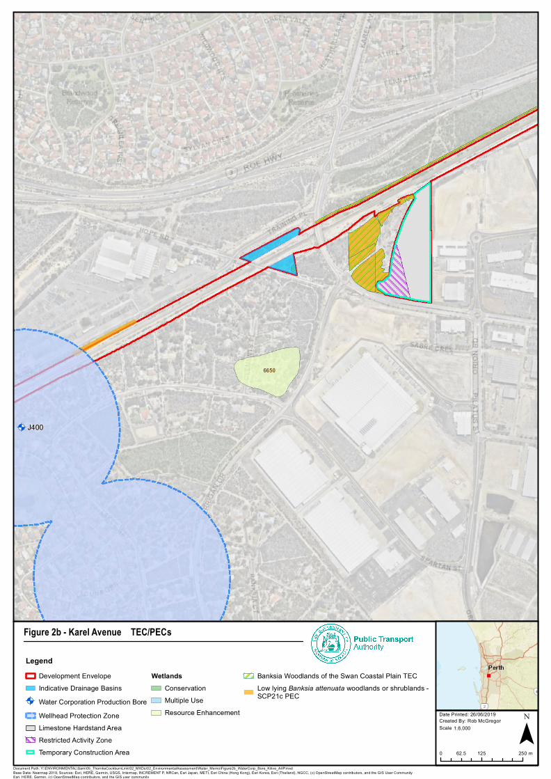
@A
6650
J400
LegendDevelopment EnvelopeIndicative Drainage Basins
@A Water Corporation Production BoreWellhead Protection ZoneLimestone Hardstand AreaRestricted Activity ZoneTemporary Construction Area
WetlandsConservationMultiple UseResource Enhancement
Banksia Woodlands of the Swan Coastal Plain TECLow lying Banksia attenuata woodlands or shrublands -SCP21c PEC
Figure 2b - Karel Avenue – TEC/PECs
Document Path: Y:\ENVIRONMENTAL\Sam\05_ThornlieCockburnLink\02_MXDs\02_EnvironmentalAssessment\Water_Memo\Figure2b_WaterCorp_Bore_KAve_A4P.mxd
Date Printed: 26/06/2019Created By: Rob McGregor ¯
Base Data: Nearmap 2018, Sources: Esri, HERE, Garmin, USGS, Intermap, INCREMENT P, NRCan, Esri Japan, METI, Esri China (Hong Kong), Esri Korea, Esri (Thailand), NGCC, (c) OpenStreetMap contributors, and the GIS User CommunityEsri, HERE, Garmin, (c) OpenStreetMap contributors, and the GIS user community
1:8,000Scale
0 125 25062.5 m

388
6911
13332
6910
6912
LegendDevelopment EnvelopeBush Forever (Site Number Labelled)Caladenia Grove ReserveLimestone HardstandTemporary Construction
WetlandsConservation
Figure 3a - Ranford Road Station - Wetlands
Document Path: Y:\ENVIRONMENTAL\Sam\05_ThornlieCockburnLink\02_MXDs\02_EnvironmentalAssessment\Water_Memo\Figure3a_Wetlands_A4P.mxd
Date Printed: 26/06/2019Created By: Rob McGregor ¯
Base Data: Nearmap 2018, Sources: Esri, HERE, Garmin, USGS, Intermap, INCREMENT P, NRCan, Esri Japan, METI, Esri China (Hong Kong), Esri Korea, Esri (Thailand), NGCC, (c) OpenStreetMap contributors, and the GIS User CommunityEsri, HERE, Garmin, (c) OpenStreetMap contributors, and the GIS user community
1:5,000Scale
0 75 15037.5 m

!(
!(
!(
!(!(
!(
!(
388
Legend!( Caladenia huegelii (T)
Development EnvelopeBush Forever (Site Number Labelled)Limestone Hardstand AreaTemporary Construction Area
Banksia Woodlands of the Swan Coastal Plain TECInferred TECLow lying Banksia attenuata woodlands or shrublands -SCP21c PEC
Figure 3b - Ranford Road Station – TEC/PECs
Document Path: Y:\ENVIRONMENTAL\Sam\05_ThornlieCockburnLink\02_MXDs\02_EnvironmentalAssessment\Water_Memo\Figure3b_TECPEC_A4P.mxd
Date Printed: 26/06/2019Created By: Rob McGregor ¯
Base Data: Nearmap 2018, Sources: Esri, HERE, Garmin, USGS, Intermap, INCREMENT P, NRCan, Esri Japan, METI, Esri China (Hong Kong), Esri Korea, Esri (Thailand), NGCC, (c) OpenStreetMap contributors, and the GIS User CommunityEsri, HERE, Garmin, (c) OpenStreetMap contributors, and the GIS user community
1:5,000Scale
0 75 15037.5 m

456
13537
7353
13533
13621
7446
LegendDevelopment EnvelopeIndicative Drainage BasinsPossible DewateringBush Forever (Site Number Labelled)
WetlandsConservationMultiple UseResource Enhancement
Figure 4 - Nicholson Road Station
Document Path: Y:\ENVIRONMENTAL\Sam\05_ThornlieCockburnLink\02_MXDs\02_EnvironmentalAssessment\Water_Memo\Figure4_NicholsonRd_A4P.mxd
Date Printed: 26/06/2019Created By: Rob McGregor ¯
Base Data: Nearmap 2018, Sources: Esri, HERE, Garmin, USGS, Intermap, INCREMENT P, NRCan, Esri Japan, METI, Esri China (Hong Kong), Esri Korea, Esri (Thailand), NGCC, (c) OpenStreetMap contributors, and the GIS User CommunityEsri, HERE, Garmin, (c) OpenStreetMap contributors, and the GIS user community
1:6,000Scale
0 90 18045 m

456
456
13622
13621
7446
LegendPedestrian Bridge DesignDevelopment EnvelopeBush Forever (Site Number Labelled)Possible Dewatering AreaTemporary Construction AreaNative Vegetation Retention Area
WetlandsConservationMultiple Use
Figure 5a - Tom Bateman Reserve Temporary Construction Areaand Pedestrian Footbridge
Document Path: Y:\ENVIRONMENTAL\Sam\05_ThornlieCockburnLink\02_MXDs\02_EnvironmentalAssessment\Water_Memo\Figure5a_TomBateman_TCA_FB_A4P.mxd
Date Printed: 26/06/2019Created By: Rob McGregor ¯
Base Data: Nearmap 2018, Sources: Esri, HERE, Garmin, USGS, Intermap, INCREMENT P, NRCan, Esri Japan, METI, Esri China (Hong Kong), Esri Korea, Esri (Thailand), NGCC, (c) OpenStreetMap contributors, and the GIS User CommunityEsri, HERE, Garmin, (c) OpenStreetMap contributors, and the GIS user community
1:5,000Scale
0 75 15037.5 m

456
456
13622
13621
7446
LegendPedestrian Bridge DesignDevelopment EnvelopeBush Forever (Site Number Labelled)Possible Dewatering Area
Access TrackLimestone Hardstand AreaRestricted Activity ZoneTemporary Construction AreaNative Vegetation Retention Area
WetlandsConservationMultiple Use
Figure 5b - Tom Bateman Reserve Temporary Construction Area – Further Detail
Document Path: Y:\ENVIRONMENTAL\Sam\05_ThornlieCockburnLink\02_MXDs\02_EnvironmentalAssessment\Water_Memo\Figure5b_TomBatement_TCA_FD_A4P.mxd
Date Printed: 26/06/2019Created By: Rob McGregor ¯
Base Data: Nearmap 2018, Sources: Esri, HERE, Garmin, USGS, Intermap, INCREMENT P, NRCan, Esri Japan, METI, Esri China (Hong Kong), Esri Korea, Esri (Thailand), NGCC, (c) OpenStreetMap contributors, and the GIS User CommunityEsri, HERE, Garmin, (c) OpenStreetMap contributors, and the GIS user community
1:5,000Scale
0 75 15037.5 m
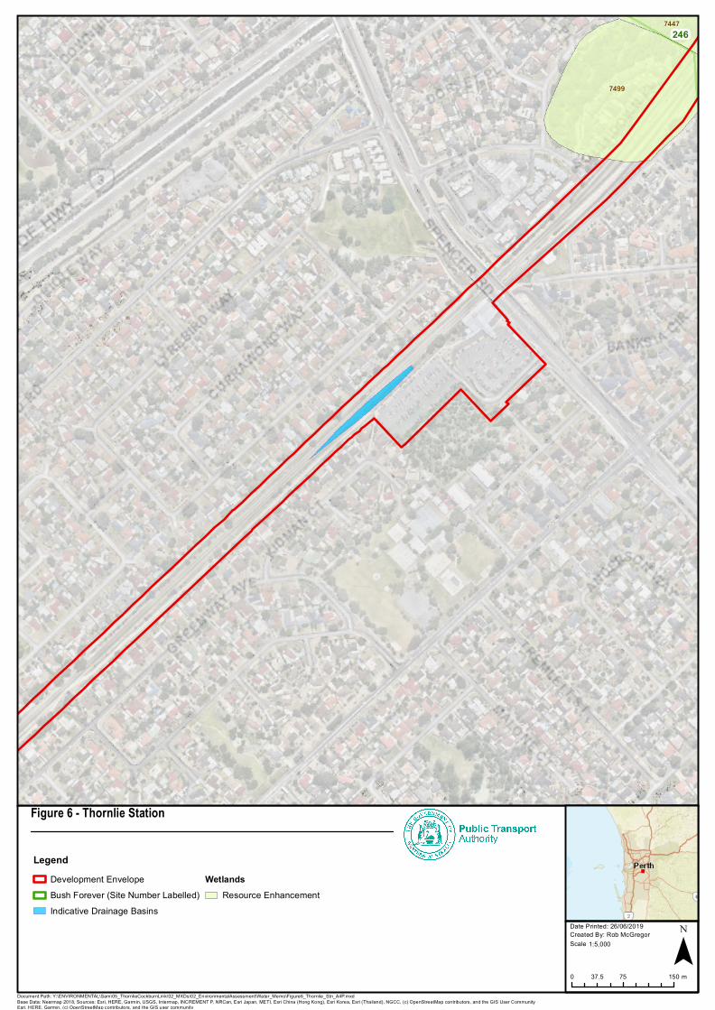
2467447
7499
LegendDevelopment EnvelopeBush Forever (Site Number Labelled)Indicative Drainage Basins
WetlandsResource Enhancement
Figure 6 - Thornlie Station
Document Path: Y:\ENVIRONMENTAL\Sam\05_ThornlieCockburnLink\02_MXDs\02_EnvironmentalAssessment\Water_Memo\Figure6_Thornlie_Stn_A4P.mxd
Date Printed: 26/06/2019Created By: Rob McGregor ¯
Base Data: Nearmap 2018, Sources: Esri, HERE, Garmin, USGS, Intermap, INCREMENT P, NRCan, Esri Japan, METI, Esri China (Hong Kong), Esri Korea, Esri (Thailand), NGCC, (c) OpenStreetMap contributors, and the GIS User CommunityEsri, HERE, Garmin, (c) OpenStreetMap contributors, and the GIS user community
1:5,000Scale
0 75 15037.5 m

224
246
246
LegendCanning River Rail Bridge DuplicationConcept DesignDevelopment EnvelopeBush Forever (Site Number Labelled)FloodwayFlood Fringe
Access TrackIndicative Riverbank Rehabilitation ZoneLimestone Hardstand AreaRestricted Activity ZoneTemporary Construction AreaNative Vegetation Retention Area
Figure 7a - Canning River Rail Bridge Duplication andConstruction Area
Document Path: \\ptcvwpfsipmp01\B_PlanningProperty\ENVIRONMENTAL\Sam\05_ThornlieCockburnLink\02_MXDs\02_EnvironmentalAssessment\Water_Memo\Figure7a_CanningB_Floodway_A4P.mxd
Date Printed: 26/06/2019Created By: Rob McGregor ¯
Base Data: Nearmap 2018, Sources: Esri, HERE, Garmin, USGS, Intermap, INCREMENT P, NRCan, Esri Japan, METI, Esri China (Hong Kong), Esri Korea, Esri (Thailand), NGCC, © OpenStreetMap contributors, and the GIS User CommunityEsri, HERE, Garmin, © OpenStreetMap contributors, and the GIS user community
1:5,000Scale
0 75 15037.5 m
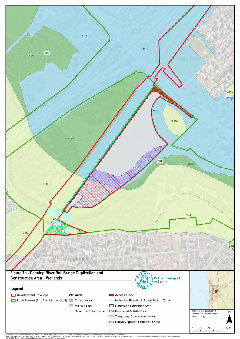
224
246
246
7447
14455
15926
7499
7733
14450
14899
14453
15949
15925
14900
14901
LegendDevelopment EnvelopeBush Forever (Site Number Labelled)
WetlandsConservationMultiple UseResource Enhancement
Access TrackIndicative Riverbank Rehabilitation ZoneLimestone Hardstand AreaRestricted Activity ZoneTemporary Construction AreaNative Vegetation Retention Area
Figure 7b - Canning River Rail Bridge Duplication andConstruction Area – Wetlands
Document Path: Y:\ENVIRONMENTAL\Sam\05_ThornlieCockburnLink\02_MXDs\02_EnvironmentalAssessment\Water_Memo\Figure7b_CanningB_Wetlands_A4P.mxd
Date Printed: 26/06/2019Created By: Rob McGregor ¯
Base Data: Nearmap 2018, Sources: Esri, HERE, Garmin, USGS, Intermap, INCREMENT P, NRCan, Esri Japan, METI, Esri China (Hong Kong), Esri Korea, Esri (Thailand), NGCC, (c) OpenStreetMap contributors, and the GIS User CommunityEsri, HERE, Garmin, (c) OpenStreetMap contributors, and the GIS user community
1:5,000Scale
0 75 15037.5 m