Embed Size (px)
Citation preview
Attachment 4 – New SmartTrack and RER Stations Planning and Technical Update
1. Introduction
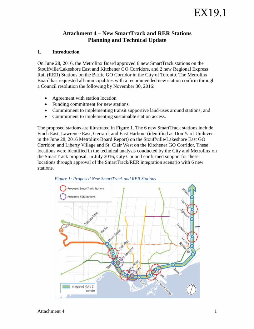
On June 28, 2016, the Metrolinx Board approved 6 new SmartTrack stations on the Stouffville/Lakeshore East and Kitchener GO Corridors, and 2 new Regional Express Rail (RER) Stations on the Barrie GO Corridor in the City of Toronto. The Metrolinx Board has requested all municipalities with a recommended new station confirm through a Council resolution the following by November 30, 2016:
• Agreement with station location• Funding commitment for new stations• Commitment to implementing transit supportive land-uses around stations; and• Commitment to implementing sustainable station access.
The proposed stations are illustrated in Figure 1. The 6 new SmartTrack stations include Finch East, Lawrence East, Gerrard, and East Harbour (identified as Don Yard-Unilever in the June 28, 2016 Metrolinx Board Report) on the Stouffville/Lakeshore East GO Corridor, and Liberty Village and St. Clair West on the Kitchener GO Corridor. These locations were identified in the technical analysis conducted by the City and Metrolinx on the SmartTrack proposal. In July 2016, City Council confirmed support for these locations through approval of the SmartTrack/RER integration scenario with 6 new stations.
Figure 1: Proposed New SmartTrack and RER Stations
Attachment 4 1
EX19.1
Metrolinx has also identified new GO RER stations across the network, including two stations located on the Barrie GO Corridor in the City of Toronto at Spadina/Front and Bloor/Lansdowne. This attachment provides an overview of preliminary findings and key considerations at each station location that will serve as input to the station planning, design and procurement process. 2. Process An initial business case analysis was developed for each station as part of Metrolinx's New Stations Analysis process. Each business case includes an assessment of potential costs and benefits of each station from a strategic, financial, economic, and deliverability perspective, and a preliminary conceptual plan for each station. The Class 5 Cost Estimates presented in EX16.1 Developing Toronto's Transit Network Plan to 2031 were based on preliminary infrastructure and property requirements identified in the conceptual plans for each station through these initial business cases. A working group with representation from the City of Toronto, Toronto Transit Commission (TTC), and Metrolinx, was established to undertake required planning and technical work to identify station access requirements and opportunities for transit supportive development. Station concepts developed as part of Metrolinx's initial business case process were the basis for review. Opportunities and challenges were identified for each station through the working group sessions and are discussed in detail below. In some cases, adjusting the location of the station platforms was also discussed. 3. Overview of Initial Station Design Issues Station Access The City encourages the use of alternative modes of mobility, including transit and active forms of transportation by integrating pedestrian and cycling infrastructure into the design of transit facilities and mobility hubs, streets, neighbourhoods, and major destinations. The City of Toronto has several initiatives that support a policy of increasing the proportion of trips made by walking, cycling, and transit and reduce the demand for vehicular travel. This includes Official Plan policies as well as numerous other plans and strategies including the Complete Streets Guidelines, the Cycling Master Plan, the PATH Pedestrian Master Plan, and Design Guidelines for 'Greening' Surface Parking Lots. For all transit stations located in the City of Toronto, the prioritization of pedestrian and cycling transportation networks and accesses in and around station areas is key to contributing to an attractive, safe and comfortable environment. To this end, the City will continue supporting, building and improving pedestrian and cycling infrastructure that connects and contributes to transit services and strengthens local communities. Each
Attachment 4 2
station entrance will need to be planned and designed to have a strong presence on a public street, integrated within the urban fabric, and respectful of the local context. Integrating station entrances with development will be encouraged in the design of these stations. The seamless integration of TTC bus and streetcar connections with new SmartTrack and GO RER stations is also essential to the success of these new stations. Currently, TTC operates high-frequency service intersecting all planned station sites. Quick, convenient, and comfortable transfers are required from local bus and streetcar service to these stations, whether through improved on-street connections or new integrated off-street facilities. In addition, the TTC has identified opportunities for changes and extensions to the streetcar network to improve connectivity to stations on Toronto’s east side. The City, TTC and Metrolinx will work together to advance these connections as station planning and design work progresses. City Planning does not support having commuter parking at any new SmartTrack or RER stations in Toronto. Commuter parking would provide minimal benefit and is not consistent with the planning policies of either the City or the Province, including the City's Official Plan, the Ministry of Transportation's Transit-Supportive Guidelines, and Metrolinx's Mobility Hub Guidelines. While the availability of commuter parking may provide an incentive for some people to ride transit, the impact of this on transit ridership is minimal. The TTC system currently has approximately 14,000 parking spaces associated with transit stations. A very small number of the TTC's approximately 1.5 million daily riders make use of these spots. The provision of commuter parking lots also includes ongoing costs for operating, maintenance, and refurbishment. Other costs associated with the provision of commuter parking lots at stations include land acquisition, construction and cash-in-lieu of property tax. According to Toronto Parking Authority data, the costs of providing commuter parking are not fully recoverable through the collection of parking fees. At most existing GO Rail stations, off-street multi-lane passenger pick-up and drop-off (PPUDO) facilities are provided as part of the station area to allow automobile drivers to safely pick-up or drop-off passengers who then board the GO transit system. TTC also provides formal PPUDO facilities at a number of subway stations, primarily at end-of-the-line and suburban stations where the surrounding context has not traditionally been conducive to informal pick-up and drop-off from the street. PPUDO facilities are also provided to meet accessibility standards, per Ontario's Accessibility for Ontarians with Disabilities Act. Formal off-street PPUDO facilities typically include a large area to accommodate queuing vehicles.
Although the City's Official Plan does not currently have a policy on PPUDOs, City Planning is not supportive of including conventional multi-lane PPUDOs provided at existing GO stations as part of any new SmartTrack or RER station area. Acknowledging
that stations must be fully accessible, accessible loading and unloading areas for TTC Wheel-Trans and other paratransit providers will need to be provided at all stations in close proximity to station entrances. City Planning staff supports planning for these
Attachment 4 3
activities within a public right-of-way, or integrated with adjacent development. Solutions could include lay-bys or the identification of areas where the slowing of traffic will not impact other uses or surrounding neighbourhoods. Further work will be required to determine suitable approaches for passenger pick-up and drop-off for each station to take into account the potential for interference with transit operations and general traffic flows, as well as potential impacts on surrounding neighbourhoods.
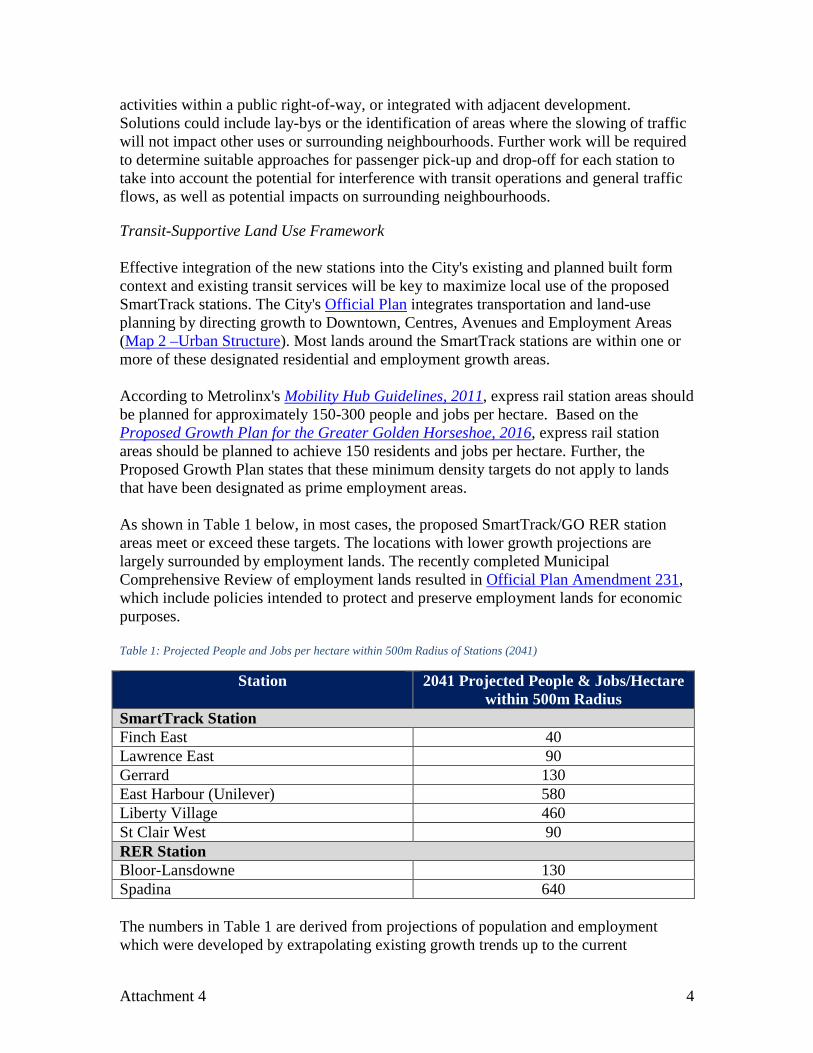
Transit-Supportive Land Use Framework Effective integration of the new stations into the City's existing and planned built form context and existing transit services will be key to maximize local use of the proposed SmartTrack stations. The City's Official Plan integrates transportation and land-use planning by directing growth to Downtown, Centres, Avenues and Employment Areas (Map 2 –Urban Structure). Most lands around the SmartTrack stations are within one or more of these designated residential and employment growth areas. According to Metrolinx's Mobility Hub Guidelines, 2011, express rail station areas should be planned for approximately 150-300 people and jobs per hectare. Based on the Proposed Growth Plan for the Greater Golden Horseshoe, 2016, express rail station areas should be planned to achieve 150 residents and jobs per hectare. Further, the Proposed Growth Plan states that these minimum density targets do not apply to lands that have been designated as prime employment areas. As shown in Table 1 below, in most cases, the proposed SmartTrack/GO RER station areas meet or exceed these targets. The locations with lower growth projections are largely surrounded by employment lands. The recently completed Municipal Comprehensive Review of employment lands resulted in Official Plan Amendment 231, which include policies intended to protect and preserve employment lands for economic purposes. Table 1: Projected People and Jobs per hectare within 500m Radius of Stations (2041)
Station 2041 Projected People & Jobs/Hectare within 500m Radius
SmartTrack Station Finch East 40 Lawrence East 90 Gerrard 130 East Harbour (Unilever) 580 Liberty Village 460 St Clair West 90 RER Station Bloor-Lansdowne 130 Spadina 640 The numbers in Table 1 are derived from projections of population and employment which were developed by extrapolating existing growth trends up to the current
Attachment 4 4
permissible zoning with an overlay of the results from a study of office nodes within the GTA conducted by Strategic Regional Research Alliance (SRRA). The study identified areas for which additional office development would be expected as a result of SmartTrack. It is important to note that the areas around the proposed stations at Finch East, Gerrard, St. Clair West and Bloor-Lansdowne Stations were not considered to be office nodes due to their lack of existing office buildings. Projections at these stations do not consider the potential boost to development resulting from the investment in the SmartTrack stations. Further, the projections were developed using the traffic zone system which, due to their size, means that projected growth in the relatively smaller station area could be over- or understated. An understatement is more likely since the development triggered by the proposed new stations would most likely occur close to the station. As a result, the projections should be seen as conservative estimates of how many people and jobs could be accommodated around the stations based on the current planning regime. Each station area will evolve and develop differently given the location, context, and market conditions. Through employment lands policies and appropriate incentives, the City will pursue ways to encourage and implement higher density employment uses such as office development in these areas to ensure that employment concentrations can be distributed across the city. In addition, the opportunity to increase employment and ridership on higher order transit can be achieved through a provincial regulation on conditional zoning to allow the City to require and secure employment uses. At the same time, City staff is mindful of the potential for increased pressure for conversion of employment areas to residential uses. Therefore, as refined station concepts are prepared, the development opportunities around each station will also be refined to identify opportunities and issues to maximize transit supportive uses. Initial design requirements of each proposed new station are outlined below. Further technical planning and design requirements will be identified as the station concepts are defined as part of the environmental assessment and procurement processes. 4. Key Design Issues for Each Station St. Clair West SmartTrack Station Station Description St. Clair West Station is proposed to be located on the Kitchener GO Corridor at St. Clair Avenue West, between Weston Road/Keele Street and Old Weston Road. This station will serve as an important point of transfer within the transit network including with the 512 St. Clair streetcar and the 41 Keele, 89 Weston, 127 Davenport, and 168 Symington buses. Approximately 10,000 surface transit riders currently pass this station location each day.
Attachment 4 5
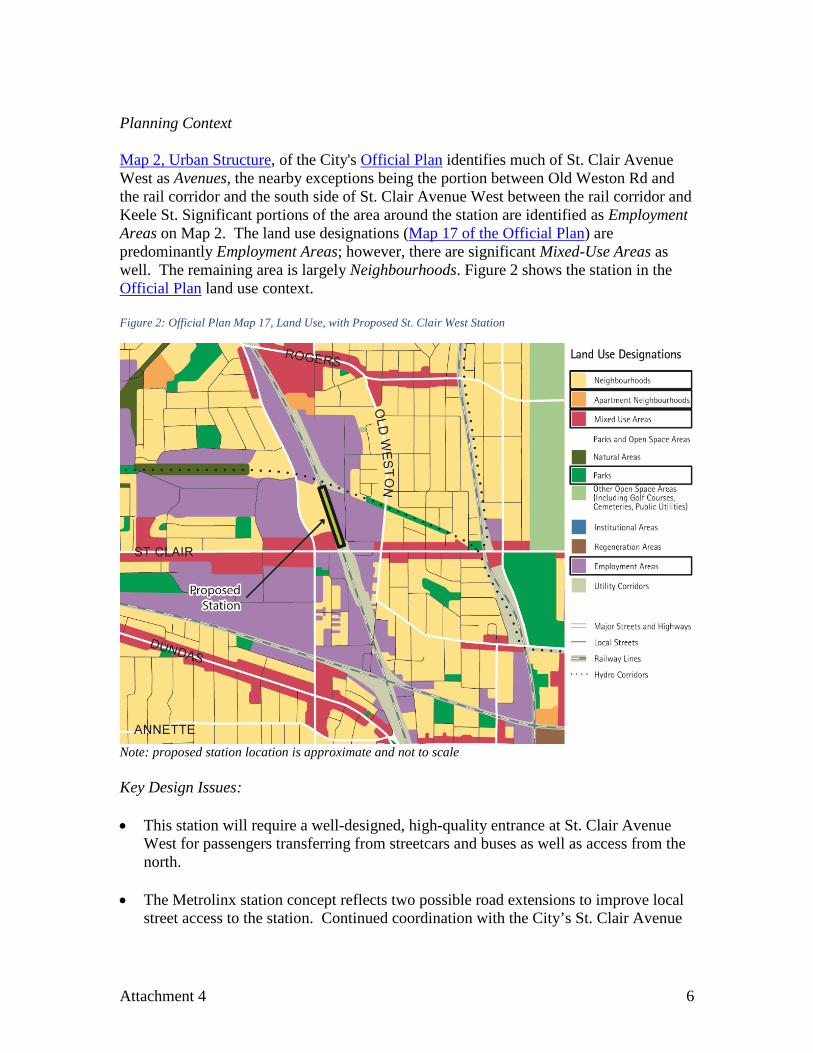
Planning Context Map 2, Urban Structure, of the City's Official Plan identifies much of St. Clair Avenue West as Avenues, the nearby exceptions being the portion between Old Weston Rd and the rail corridor and the south side of St. Clair Avenue West between the rail corridor and Keele St. Significant portions of the area around the station are identified as Employment Areas on Map 2. The land use designations (Map 17 of the Official Plan) are predominantly Employment Areas; however, there are significant Mixed-Use Areas as well. The remaining area is largely Neighbourhoods. Figure 2 shows the station in the Official Plan land use context. Figure 2: Official Plan Map 17, Land Use, with Proposed St. Clair West Station
Note: proposed station location is approximate and not to scale Key Design Issues: • This station will require a well-designed, high-quality entrance at St. Clair Avenue
West for passengers transferring from streetcars and buses as well as access from the north.
• The Metrolinx station concept reflects two possible road extensions to improve local
street access to the station. Continued coordination with the City’s St. Clair Avenue
Attachment 4 6
West Area Transportation Master Plan will be needed. The Plan is currently being developed and is expected to be complete by early 2017.
• There is an opportunity to coordinate planning, design and project delivery of station
with the St. Clair West Transportation Master Plan and other related area infrastructure improvements, such as improved road connections and reconstruction of the St. Clair Avenue West bridge.
• Access to the station should focus on pedestrians, cyclists and connecting transit
services. No commuter parking spaces should be included as part of the station (none are shown in the Metrolinx station concept). Care will be needed in planning for a fully accessible station; however, a conventional GO multi-lane PPUDO facility is not supported by City Planning.
• Adequate and convenient bicycle parking facilities will be needed at the station (the Metrolinx station concept identifies bike parking at key station access points)
• An accessible loading and unloading area needs to be provided in close proximity to
the station entrance. TTC Wheel-Trans will use this area or a bus bay in an off-street bus terminal, if provided.
• The Metrolinx station concept includes a bus loop to replace the existing Townsley Loop at Old Weston Road, which would allow for the 127 Davenport bus route to be extended to directly serve the station. A high-quality connection for passengers transferring between the station platform and streetcars and buses on St. Clair Avenue West, Weston Road/Keele Street and Old Weston Road is required. Further analysis is required to develop concepts for connecting bus and streetcar routes, identify required on- and off-street facilities to provide seamless connectivity between transit modes, and identify any new capital and operating requirements for TTC budgetary purposes.
• A direct connection between the streetcar and the station would be desirable.
Geometric conditions at the underpass of St. Clair Avenue West to the rail corridor make such a connection very challenging. The project team for the St. Clair Avenue West – Transportation Master Plan is considering options to provide this connection. One potential option identified by the TTC is to provide a spur of the 512 St. Clair streetcar on Old Weston Road and Townsley Street into the station. In this case, a streetcar loop would need to be provided at the station.
Liberty Village SmartTrack Station Station Description The Liberty Village Station is proposed to be located on the Kitchener GO Corridor just north of King Street West, east of Dufferin Street.
Attachment 4 7
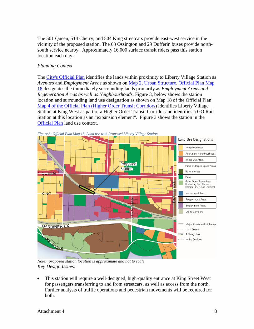
The 501 Queen, 514 Cherry, and 504 King streetcars provide east-west service in the vicinity of the proposed station. The 63 Ossington and 29 Dufferin buses provide north-south service nearby. Approximately 16,000 surface transit riders pass this station location each day. Planning Context The City's Official Plan identifies the lands within proximity to Liberty Village Station as Avenues and Employment Areas as shown on Map 2, Urban Structure. Official Plan Map 18 designates the immediately surrounding lands primarily as Employment Areas and Regeneration Areas as well as Neighbourhoods. Figure 3, below shows the station location and surrounding land use designation as shown on Map 18 of the Official Plan Map 4 of the Official Plan (Higher Order Transit Corridors) identifies Liberty Village Station at King West as part of a Higher Order Transit Corridor and identifies a GO Rail Station at this location as an "expansion element". Figure 3 shows the station in the Official Plan land use context. Figure 3: Official Plan Map 18, Land use with Proposed Liberty Village Station
Note: proposed station location is approximate and not to scale Key Design Issues: • This station will require a well-designed, high-quality entrance at King Street West
for passengers transferring to and from streetcars, as well as access from the north. Further analysis of traffic operations and pedestrian movements will be required for both.
Attachment 4 8
• Access to the station should focus on pedestrians, cyclists and connecting transit
services. No commuter parking spaces should be included as part of the station (none are shown in the Metrolinx station concept). Care will be needed in planning for a fully accessible station; however, a conventional GO multi-lane PPUDO facility is not supported by City Planning.
• Adequate and convenient bicycle parking facilities will be needed at the station. • An accessible loading and unloading area will need to be provided in close proximity
to the station entrance, with space for TTC Wheel-Trans use. • The proposed station concept provides the opportunity to improve pedestrian and
cycling connectivity between Liberty Village, the Queen West Triangle, and King Street West Communities, and integrate with the West Toronto Rail Path and planned and approved area pedestrian bridges.
• The station concept identifies a developer-proposed "King High Line". Additional
consideration should be made for an over-rail corridor access to allow pedestrians and cyclists to cross the rail corridor and provide additional access the station.
• Several area development proposals and approvals, such as the proposal at 99
Sudbury Street and the approved development at 1100 King Street West, may present opportunities to achieve connections between the proposed station and the surrounding area. Further consultation between the City, Metrolinx, and area landowners will be needed in order to explore these opportunities in greater detail as part of the station design.
• There are potential requirements for noise walls and drainage to mitigate
environmental impacts which will require further evaluation as part of the environmental assessment process.
• Liberty Village is a highly sensitive area with respect to heritage resources and contains structures with heritage status. The rail bridge is a Heritage Bridge, which will need to be carefully reviewed as part of the design process to ensure compatibility and any impacts will need to be mitigated. Removal of any original heritage fabric will need to be carried out carefully. 55 Sudbury (a potential station entrance) is a registered heritage building which is provincially protected under the Heritage Act. Metrolinx will need to work closely with the City under the Province’s heritage preservation policies to ensure appropriate attention is given to the heritage attributes of this property.
• There may be opportunities for the preservation/adaptive reuse of area heritage
buildings, including the heritage bridge above King Street West, in the context of station construction.
Attachment 4 9
• The Garrison Commons Secondary Plan, which includes the area for Liberty Village station, is currently under review. There is an opportunity to consider the parks and public realm and pedestrian and cyclist connections within the station area further through the Secondary Plan update.
East Harbour (Unilever) SmartTrack Station Station Description A new station along the Stouffville/Lakeshore East GO Corridors is planned to serve emerging waterfront communities west of the Don River as well as a major proposed development (East Harbour) on the former Lever Brothers site (Unilever). The station is proposed to be located on the east side of the Don River, to the north of Lake Shore Boulevard, south of Eastern Avenue.1 The City is conducting a planning study to comprehensively plan for a concentration of new employment uses in this area, referred to as the "Unilever Precinct", and forming part of the South of Eastern Employment Area. A preliminary application for an Official Plan Amendment for the Unilever Precinct is being considered. It is proposed to result in approximately 50,000 jobs when fully built out. Discussions with landowners, Metrolinx, and City staff are underway to assess technical issues related to planning the station integration with the future development of the precinct. The primary Precinct landowner and East Harbour proponent, First Gulf, has expressed willingness to be a funding partner for design and construction of the station. East Harbour will be a significant interchange station, providing connections with the planned Relief Line and Broadview streetcar extension. The station will be the most direct rapid transit gateway in the network to the future development planned in the Port Lands. The immediate station area is not currently served directly by any transit routes. GO trains along Lakeshore East and Stouffville GO corridors pass through the area but do not stop. The 143 Downtown/Beach Express bus operates on Eastern Avenue north of the proposed station but does not stop in the area. The 501 Queen, 502 Downtowner, 503 Kingston Rd, 504 King streetcar routes operating on Queen Street East north of the proposed station are the closest existing transit connection available. A new future north-south streetcar route on the existing and planned extension of Broadview Avenue is planned, as part of the port lands redevelopment. Planning Context Map 2, Urban Structure, of the City's Official Plan shows the East Harbour station area as Employment Areas and the land use designation on Map 18 of the Official Plan is Employment Areas.
1 Metrolinx is currently still reviewing the technical feasibility of this station location.
Attachment 4 10
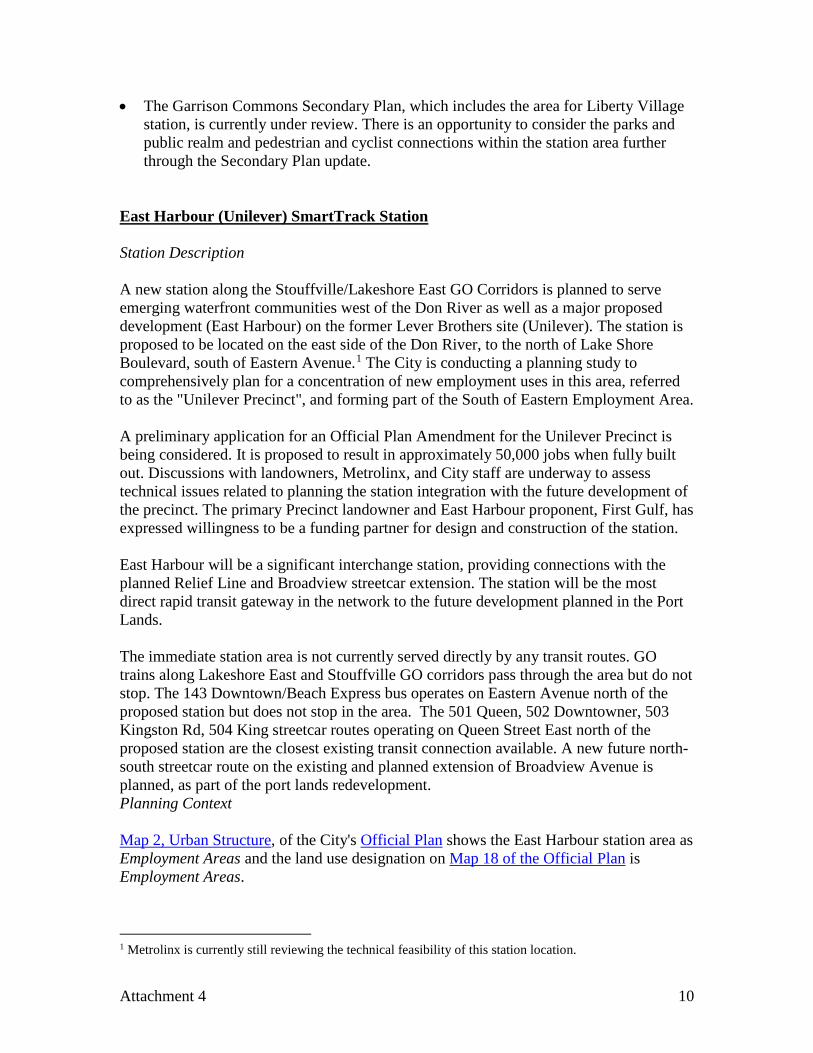
The proposed station area, along with the South of Eastern Employment Area more broadly, is within the Lower Don River flood plain and Special Policy Area (SPA). Provincial approval is required for changes in land use policy, designations or boundaries in SPAs. The Province has not issued a decision on the 2002 City of Toronto Official Plan SPA policies, a matter which continues to be subject to an Ontario Municipal Board appeal. The SPA policies of the former City of Toronto Official Plan with respect to the Lower Don remain in effect. Official Plan Amendment (OPA) No. 231, arising from the recent Municipal Comprehensive Review of Employment Lands reaffirmed the appropriateness of continued employment uses within the Unilever Precinct, retaining employment land use designations in its entirety. It also introduced Site and Area Specific Policy (SASP) 426 for a portion of the Unilever Precinct south of the rail corridor. Among other things, the SASP calls for a broad variety of non-residential land uses in a comprehensively planned employment area. The Ministry of Municipal Affairs has withheld its decision on OPA 231 SASPs within the Lower Don SPA. Portions of OPA 231, including the Ministry's lack of decision on the Lower Don SASPs, are subject to ongoing Ontario Municipal Board appeals. Figure 4 shows the station location within the in-force Official Plan land use context. Figure 4: Official Plan Map 18, Land Use with Proposed East Harbour Station
Notes: station location is approximate and not to scale; station location is still under review by Metrolinx
Attachment 4 11
Key Design Issues: • Planning and design of the East Harbour Station must be integrated with the overall
comprehensive employment Precinct planning, including station location.
• This station will require a well-designed, high-quality entrance(s) at Broadview Avenue for passengers transferring from the future streetcar line. Main entrances on Broadview Avenue both north and south of the rail corridor should be generous and clearly accessible from the public realm. The station will also need to incorporate strong access connections to the future Relief Line station proposed at Eastern Avenue and Broadview Avenue. Access should also be provided at the west end of the station across the river to the Don Valley multi-use path.
• Access to the station should focus on pedestrians, cyclists and connecting transit
services. No commuter parking spaces should be included as part of the station (none are contemplated in the station concept). Care will be needed in planning for a fully accessible station; however, a conventional GO multi-lane PPUDO facility is not supported by City Planning.
• Adequate and convenient bicycle parking facilities will be needed at the station. • An accessible loading and unloading area will need to be provided in close proximity
to the station entrance, with space for TTC Wheel-Trans use.
• Depending on the timing and phasing of implementation of the Broadview Avenue streetcar extension and surrounding development, a temporary loop may be required at this station site. Ultimately, the Broadview Avenue streetcar is envisioned to terminate at an off-street loop in the area of Bouchette Street and Commissioners Street.
• Further investigation will be needed regarding potential infrastructure conflicts
between the rail bridge widening required to accommodate a station straddling the Don River and Don Valley Parkway, and the vertical clearances required for the Gardiner Expressway ramp reconfiguration under the Hybrid #3 option approved by Council March 2016. Metrolinx is currently investigating the technical and operational feasibility of the East Harbour location in consultation with the City of Toronto and Waterfront Toronto.
• The proposed west station access at the Don Valley multi-use path is an important
pedestrian and cycling connection to link the new West Don Lands community to the station, and would allow users of the multi-use path to connect across the river. Lighting, orientation and design of this connection should achieve design excellence and promote comfortable usage year-round in all conditions.
Attachment 4 12
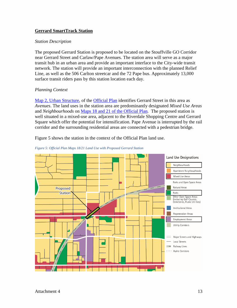
Gerrard SmartTrack Station Station Description The proposed Gerrard Station is proposed to be located on the Stouffville GO Corridor near Gerrard Street and Carlaw/Pape Avenues. The station area will serve as a major transit hub in an urban area and provide an important interface to the City-wide transit network. The station will provide an important interconnection with the planned Relief Line, as well as the 506 Carlton streetcar and the 72 Pape bus. Approximately 13,000 surface transit riders pass by this station location each day. Planning Context Map 2, Urban Structure, of the Official Plan identifies Gerrard Street in this area as Avenues. The land uses in the station area are predominantly designated Mixed Use Areas and Neighbourhoods on Maps 18 and 21 of the Official Plan. The proposed station is well situated in a mixed-use area, adjacent to the Riverdale Shopping Centre and Gerrard Square which offer the potential for intensification. Pape Avenue is interrupted by the rail corridor and the surrounding residential areas are connected with a pedestrian bridge. Figure 5 shows the station in the context of the Official Plan land use. Figure 5: Official Plan Maps 18/21 Land Use with Proposed Gerrard Station
Attachment 4 13
Notes: proposed station location is approximate and not to scale; location is shifted per working group discussions Carlaw-Dundas is a former industrial area that has been undergoing a transformation, emerging as a mixed-use cultural hub of workers and residents. The area has seen considerable growth and change with significant residential construction taking place in the last six years. The Carlaw-Dundas area is subject to Site and Area Specific Policy 247 that permits residential and live/work uses. The area is further identified in the Carlaw + Dundas Community Initiative, which seeks as part of its nine principles to: support the use of public transit in the area, maintain the historic industrial character of the Carlaw-Dundas area, and ensure that new development is compatible with surrounding neighbourhoods. Key Design Issues: • The station should be located in close proximity to both Pape Avenue and Carlaw
Avenue, to best serve the local community, improve neighbourhood connections over the rail corridor, reflect redevelopment potential, and provide interconnection with the Relief Line. This requires a shift in the station location from the concept plan developed as part of Metrolinx's initial business case process. Further analysis is needed to determine potential impacts of this shift on Gerrard Square.
• This station will require well-designed, high-quality access at each of the surrounding major roadways and should include consideration for accessible ramp connections, enhancement of pedestrian underpass connections, indoor bike parking, and improved pedestrian bridge connections. The station will also need to incorporate strong access connections to the future Relief Line station.
• Access to the station should focus on pedestrians, cyclists and connecting transit
services. No commuter parking spaces should be included as part of the station (none are shown in the Metrolinx station concept). Care will be needed in planning for a fully accessible station; however, a conventional GO multi-lane PPUDO facility is not supported by City Planning. The accommodation for informal passenger pick-up and drop-off needs to be studied further to ensure that this activity does not interfere with transit or traffic operations in the area and considers the impact of traffic infiltration into the neighbourhood.
• Adequate and convenient bicycle parking facilities will be needed at the station. • An accessible loading and unloading area will be provided in close proximity to the
station entrance. TTC Wheel-Trans will use this area or a bus bay in an off-street bus terminal, if provided.
• TTC has completed an initial review of potential bus and streetcar connections to the
new station. This includes the extension of the 505 Dundas streetcar via Dundas Street East or Gerrard Street, terminating at the station. There may also be changes to the 72 Pape bus route and extension of bus service (such as the 25 Don Mills or 81
Attachment 4 14
Thorncliffe Park) from Pape Station. The conceptual connecting network will be used to inform requirements for off-street bus and streetcar facilities at this station and any new capital and operating requirements for TTC budgetary purposes.
• Currently the station location is not directly served by any direct connection to cycle
lanes or paths; however, the City's 10 Year Cycle Plan indicates a planned route along Carlaw Avenue. The potential addition of additional transit services into the area may indicate the need to review the planned cycle network and better understand how it interfaces with the proposed station and other planned or proposed transit infrastructure in the area. Further examination of potential technical challenges will be required.
Lawrence East SmartTrack Station Station Description The Lawrence East station is proposed to be located on the Stouffville GO Corridor at Lawrence Avenue East, between Kennedy Road and Midland Avenue. This area is currently served by Line 3 Scarborough, which operates at 4-5 minute headways during the peak period. This station will provide an important rapid transit connection for local residents and employees, as well as a north-south interchange for the busy surface 54 Lawrence bus route serving the area. There are approximately 7,500 all day boardings at the Line 3 Lawrence East station and approximately 10,500 surface transit riders pass this station location each day. Planning Context Map 2, Urban Structure, of the City's Official Plan identified the station area as Avenues and Employment Areas. The land use designations within the station area are generally a combination of Mixed Use Areas, Apartment Neighbourhoods, and Employment Areas on Map 20 of the Official Plan. Figure 6 shows the station in the Official Plan land use context.
Attachment 4 15
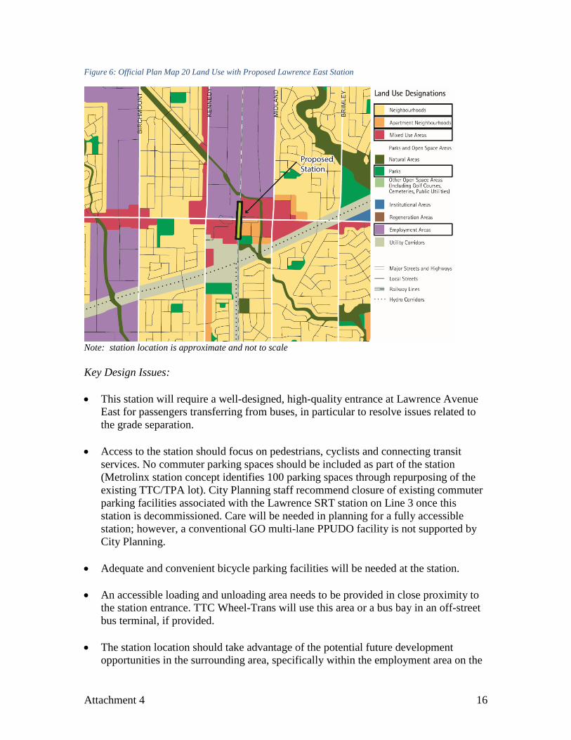
Figure 6: Official Plan Map 20 Land Use with Proposed Lawrence East Station
Note: station location is approximate and not to scale Key Design Issues: • This station will require a well-designed, high-quality entrance at Lawrence Avenue
East for passengers transferring from buses, in particular to resolve issues related to the grade separation.
• Access to the station should focus on pedestrians, cyclists and connecting transit
services. No commuter parking spaces should be included as part of the station (Metrolinx station concept identifies 100 parking spaces through repurposing of the existing TTC/TPA lot). City Planning staff recommend closure of existing commuter parking facilities associated with the Lawrence SRT station on Line 3 once this station is decommissioned. Care will be needed in planning for a fully accessible station; however, a conventional GO multi-lane PPUDO facility is not supported by City Planning.
• Adequate and convenient bicycle parking facilities will be needed at the station. • An accessible loading and unloading area needs to be provided in close proximity to
the station entrance. TTC Wheel-Trans will use this area or a bus bay in an off-street bus terminal, if provided.
• The station location should take advantage of the potential future development
opportunities in the surrounding area, specifically within the employment area on the
Attachment 4 16
north side of Lawrence. City staff request that consideration be given to shifting the station location to the north. Access to the south side of Lawrence is also important to serve emerging new mixed-use development and existing residential uses. Metrolinx has indicated that it is willing to consider this shift northward, pending confirmation that it is technically feasible.
• The 54 Lawrence East bus is a high volume east-west surface transit route serving the
Lawrence East corridor. With the elimination of the Line 3 Lawrence East Station, specifically the existing bus terminal, it will be important to ensure that surface transit riders have a good connection to the station. TTC has requested that changes to the station do not preclude the ability to turn back buses from the west or east and layover facilities for buses are retained.
• Construction of this station will need to be coordinated with the construction of the
Scarborough Subway Extension and the phasing out of the Lawrence SRT station. Metrolinx has indicated a willingness to work with the City to assess the impacts and alternatives, including considering delaying opening of the SmartTrack station until the subway extension is operational.
Finch East SmartTrack Station Station Description The Finch East station is proposed to be located on the Stouffville Corridor at Finch Ave East, between Kennedy Road and Midland Avenue. Finch East Station will serve as an important point of transfer within the transit network by providing connections with 39 Finch East and 199 Finch Rocket bus routes. Approximately 14,000 surface transit riders pass this station location each day. Planning Context Map 2, Urban Structure, of the City's Official Plan identifies the lands adjacent to this station as Employment Areas and the land use designation on Map 19 are generally Employment Areas and Neighbourhoods. Figure 7 shows the station in the Official Plan land use context.
Attachment 4 17
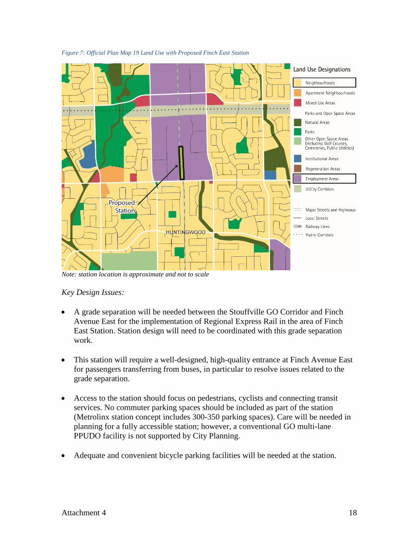
Figure 7: Official Plan Map 19 Land Use with Proposed Finch East Station
Note: station location is approximate and not to scale Key Design Issues: • A grade separation will be needed between the Stouffville GO Corridor and Finch
Avenue East for the implementation of Regional Express Rail in the area of Finch East Station. Station design will need to be coordinated with this grade separation work.
• This station will require a well-designed, high-quality entrance at Finch Avenue East
for passengers transferring from buses, in particular to resolve issues related to the grade separation.
• Access to the station should focus on pedestrians, cyclists and connecting transit
services. No commuter parking spaces should be included as part of the station (Metrolinx station concept includes 300-350 parking spaces). Care will be needed in planning for a fully accessible station; however, a conventional GO multi-lane PPUDO facility is not supported by City Planning.
• Adequate and convenient bicycle parking facilities will be needed at the station.
Attachment 4 18
• An accessible loading and unloading area needs to be provided in close proximity to the station entrance. TTC Wheel-Trans will use this area or a bus bay in an off-street bus terminal, if provided.
• Direct connections for passengers transferring from surface transit along Finch
Avenue East needs to be a key consideration for this station. TTC has indicated that five bus bays are needed to serve this station. Further analysis is needed to understand the best configuration for the bus bays, including the option for buses to stop along Finch Avenue East or to turn around and head back in the same direction from which the vehicle came. Further analysis is also required to understand the interface between the grade separation and access to an off-street bus terminal.
• The need for and location of an access road for this station needs further
consideration. RER Stations At its June 28, 2016 meeting, the Metrolinx Board approved two non-SmartTrack stations on the Barrie GO Corridor (Spadina Station and Bloor-Lansdowne Station) to be delivered as part of its RER program. City Planning supports Metrolinx in the implementation of these proposed GO RER stations. Both proposed stations would provide key connections for transit users, provide people with mobility choice, increase demand on the future GO RER system by providing connections to TTC rapid transit and significantly increase transportation accessibility. Overall, the development of GO RER, including these stations, would contribute to Toronto's city building vision. Bloor-Lansdowne RER Station In July, 2016 City Council directed staff to continue negotiations with Metrolinx to secure a new multi-modal GO/RER station in this location as part of the Davenport Diamond Grade Separation (EX16.18 - The "Missing Link" Freight Rail Alternative and Davenport Diamond Grade Separation Update). Station Description The Bloor-Lansdowne Station is proposed to be located on the Barrie Corridor, at Bloor Street West, just west of Lansdowne Avenue. This is an important location in the transit network as the Barrie GO Corridor crosses Line 2 (Bloor-Danforth) on the subway system; the Lansdowne Station entrance is located about 250 metres east of the rail corridor. Other nearby major transit stations include the existing Bloor GO Station and Bloor Union Pearson Express Station on the Kitchener Rail Corridor (approximately 360 metres west of the Barrie Corridor). The closest surface transit route is the 47 Lansdowne bus. Approximately 11,000 daily transit riders pass this station location (includes arrivals and boardings at Lansdowne Subway station).
Attachment 4 19
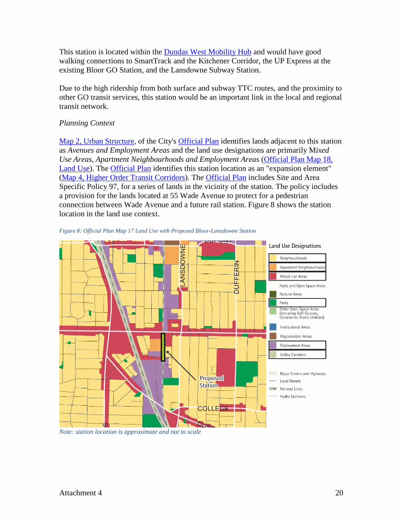
This station is located within the Dundas West Mobility Hub and would have good walking connections to SmartTrack and the Kitchener Corridor, the UP Express at the existing Bloor GO Station, and the Lansdowne Subway Station. Due to the high ridership from both surface and subway TTC routes, and the proximity to other GO transit services, this station would be an important link in the local and regional transit network. Planning Context Map 2, Urban Structure, of the City's Official Plan identifies lands adjacent to this station as Avenues and Employment Areas and the land use designations are primarily Mixed Use Areas, Apartment Neighbourhoods and Employment Areas (Official Plan Map 18, Land Use). The Official Plan identifies this station location as an "expansion element" (Map 4, Higher Order Transit Corridors). The Official Plan includes Site and Area Specific Policy 97, for a series of lands in the vicinity of the station. The policy includes a provision for the lands located at 55 Wade Avenue to protect for a pedestrian connection between Wade Avenue and a future rail station. Figure 8 shows the station location in the land use context. Figure 8: Official Plan Map 17 Land Use with Proposed Bloor-Lansdowne Station
Note: station location is approximate and not to scale
Attachment 4 20
Key Design Issues: • This station will require a well-designed, high-quality access at Bloor Street West.
• Access to the station should focus on pedestrians, cyclists and connecting transit
services. No commuter parking spaces should be included as part of the station (none are shown in the Metrolinx station concept). Care will be needed in planning for a fully accessible station; however, a conventional GO multi-lane PPUDO facility is not supported by City Planning. The accommodation for informal passenger pick-up and drop-off needs to be studied further to ensure that this activity does not interfere with transit or traffic operations in the area and considers the impact of traffic infiltration into the neighbourhood. An accessible loading and unloading area will need to be provided in close proximity to the station entrance and for TTC Wheel-Trans.
• Adequate and convenient bicycle parking facilities will be needed at the station. • The station design should consider the Metrolinx EA for the Davenport Diamond
Grade Separation project, which begins just north of Bloor Street West, and the Metrolinx EA for the Barrie GO Corridor Rail Expansion, which proposes to add a second rail track to meet future service requirements. The grade separation is a 570 metre bridge over the CP rail corridor (between Dupont Street and Davenport Road) with a berm (400-450 metres) on both approaches to the bridge section. The Environmental Project Report (EPR) for the grade separation has been completed. The Davenport Diamond Grade Separation EA included a provision for a multi-use trail along the east side of the rail corridor north of Bloor Street West and the City has requested that Metrolinx include a provision in the Barrie Rail Corridor Expansion EA for the multi-use trail south of Bloor Street West. The trail is also included in the station concept plan, and is regarded as an important component of this station to meet City building objectives.
• The Bloor Street West rail bridge may require widening to accommodate track
geometry and multi-use trail crossing of Bloor. Further analysis will be needed, including consideration of heritage implications.
• Metrolinx has identified a requirement for the City to provide an accessible, weather-
protected pedestrian link between the Bloor-Lansdowne RER Station and the Lansdowne Subway Station. City staff agrees that this is a desirable objective and, together with Metrolinx, will work towards achieving this connection.
• Further analysis and coordination with adjacent landowners is required to confirm the
desirability and feasibility of additional access points. • Further analysis of the need for noise walls is required.
Attachment 4 21
• Further analysis is required regarding potential environmental contamination of lands adjacent to the station location; remediation may be required.
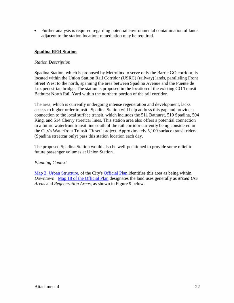
Spadina RER Station Station Description Spadina Station, which is proposed by Metrolinx to serve only the Barrie GO corridor, is located within the Union Station Rail Corridor (USRC) (railway) lands, paralleling Front Street West to the north, spanning the area between Spadina Avenue and the Puente de Luz pedestrian bridge. The station is proposed in the location of the existing GO Transit Bathurst North Rail Yard within the northern portion of the rail corridor. The area, which is currently undergoing intense regeneration and development, lacks access to higher order transit. Spadina Station will help address this gap and provide a connection to the local surface transit, which includes the 511 Bathurst, 510 Spadina, 504 King, and 514 Cherry streetcar lines. This station area also offers a potential connection to a future waterfront transit line south of the rail corridor currently being considered in the City's Waterfront Transit "Reset" project. Approximately 5,100 surface transit riders (Spadina streetcar only) pass this station location each day. The proposed Spadina Station would also be well-positioned to provide some relief to future passenger volumes at Union Station. Planning Context Map 2, Urban Structure, of the City's Official Plan identifies this area as being within Downtown. Map 18 of the Official Plan designates the land uses generally as Mixed Use Areas and Regeneration Areas, as shown in Figure 9 below.
Attachment 4 22
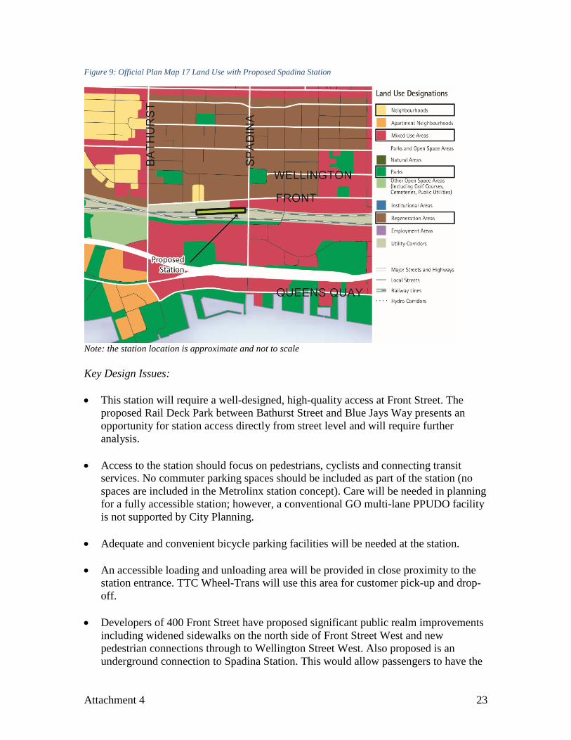
Figure 9: Official Plan Map 17 Land Use with Proposed Spadina Station
Note: the station location is approximate and not to scale Key Design Issues: • This station will require a well-designed, high-quality access at Front Street. The
proposed Rail Deck Park between Bathurst Street and Blue Jays Way presents an opportunity for station access directly from street level and will require further analysis.
• Access to the station should focus on pedestrians, cyclists and connecting transit
services. No commuter parking spaces should be included as part of the station (no spaces are included in the Metrolinx station concept). Care will be needed in planning for a fully accessible station; however, a conventional GO multi-lane PPUDO facility is not supported by City Planning.
• Adequate and convenient bicycle parking facilities will be needed at the station. • An accessible loading and unloading area will be provided in close proximity to the
station entrance. TTC Wheel-Trans will use this area for customer pick-up and drop-off.
• Developers of 400 Front Street have proposed significant public realm improvements
including widened sidewalks on the north side of Front Street West and new pedestrian connections through to Wellington Street West. Also proposed is an underground connection to Spadina Station. This would allow passengers to have the
Attachment 4 23
ability to pass through the proposed retail developments to access the station under Front Street West between Spadina Avenue and Draper Street. Currently, as part of a site plan application review process, City Planning is anticipating that there will be knockout panels at the northwest corner of Front/Spadina, positioned to the south (for station access) and to the east.
• The proposed development at 400 Front Street West, a mixed use site with a significant residential component) provides further opportunity for below grade connections and potential connections via a PATH extension to reach existing portions of the PATH network close to Front Street and John Street. These connections are at the preliminary stage of discussion. City Planning will engage the developers of 400 Front Street West and other stakeholders as required to develop these connections.
• Along with a new sidewalk on the south side of Front Street West, a second ramp on the east side of the Puente de Luz bridge landing to improve access to Front Street West and a midblock station access point will be considered.
• Improved pedestrian facilities across the Spadina Avenue bridge, including weather
protection, will connect to the high density City Place neighbourhood to the south.
• The possible future operation of a bus service or a new streetcar service on Front Street must be protected for in road and station design.
• Metrolinx has indicated that this station has the potential to significantly impact
future train operations and storage needs and further feasibility analysis is required.
5. Next Steps The next steps to advance planning and technical analysis for SmartTrack stations include:
• Environmental assessment for each station (Transit Project Assessment Process- TPAP), including community consultation;
• More detailed planning and design work to establish specifications for the procurement of engineering and detailed design of each station; and
• Service planning related to new station locations.
A report in Q3 2017 will include the draft Environmental Project Reports for the six new stations. Refined Class 4 cost estimates will be developed once 10% design has been reached, as outlined in the Stage Gate Process of the Staff Cover Report.
Attachment 4 24