Embed Size (px)
Citation preview

DUGWAY PERMIT
MODULE VII
ATTACHMENT 3
HAZARDOUS WASTE MANAGEMENT UNIT HWMU 2
POST-CLOSURE PLAN
Dugway Proving Ground Module VII
Attachment 3 – HWMU 2 Sept. 2017
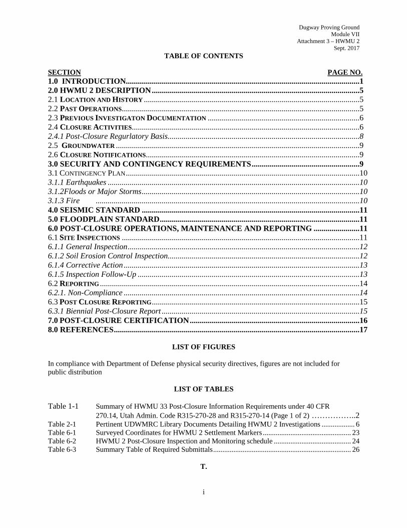
TABLE OF CONTENTS
SECTION PAGE NO. 1.0 INTRODUCTION.....................................................................................................................1 2.0 HWMU 2 DESCRIPTION ........................................................................................................5 2.1 LOCATION AND HISTORY ............................................................................................................5 2.2 PAST OPERATIONS.......................................................................................................................5 2.3 PREVIOUS INVESTIGATON DOCUMENTATION ............................................................................6 2.4 CLOSURE ACTIVITIES ..................................................................................................................6 2.4.1 Post-Closure Regurlatory Basis ................................................................................................8 2.5 GROUNDWATER ..........................................................................................................................9 2.6 CLOSURE NOTIFICATIONS...........................................................................................................9 3.0 SECURITY AND CONTINGENCY REQUIREMENTS ......................................................9 3.1 CONTINGENCY PLAN .....................................................................................................................10 3.1.1 Earthquakes ..............................................................................................................................10 3.1.2Floods or Major Storms .............................................................................................................10 3.1.3 Fire ....................................................................................................................................10 4.0 SEISMIC STANDARD .............................................................................................................11 5.0 FLOODPLAIN STANDARD ....................................................................................................11 6.0 POST-CLOSURE OPERATIONS, MAINTENANCE AND REPORTING .......................11 6.1 SITE INSPECTIONS .......................................................................................................................11 6.1.1 General Inspection ....................................................................................................................12 6.1.2 Soil Erosion Control Inspection................................................................................................12 6.1.4 Corrective Action ......................................................................................................................13 6.1.5 Inspection Follow-Up ...............................................................................................................13 6.2 REPORTING ..................................................................................................................................14 6.2.1. Non-Compliance ......................................................................................................................14 6.3 POST CLOSURE REPORTING ........................................................................................................15 6.3.1 Biennial Post-Closure Report ...................................................................................................15 7.0 POST-CLOSURE CERTIFICATION .....................................................................................16 8.0 REFERENCES ...........................................................................................................................17
LIST OF FIGURES
In compliance with Department of Defense physical security directives, figures are not included for public distribution
LIST OF TABLES Table 1-1 Summary of HWMU 33 Post-Closure Information Requirements under 40 CFR
270.14, Utah Admin. Code R315-270-28 and R315-270-14 (Page 1 of 2) ……………..2 Table 2-1 Pertinent UDWMRC Library Documents Detailing HWMU 2 Investigations .................. 6 Table 6-1 Surveyed Coordinates for HWMU 2 Settlement Markers ................................................ 23 Table 6-2 HWMU 2 Post-Closure Inspection and Monitoring schedule .......................................... 24 Table 6-3 Summary Table of Required Submittals ........................................................................... 26
T.
i
Dugway Proving Ground Module VII
Attachment 3 – HWMU 2 Sept. 2017
LIST OF APPENDICES
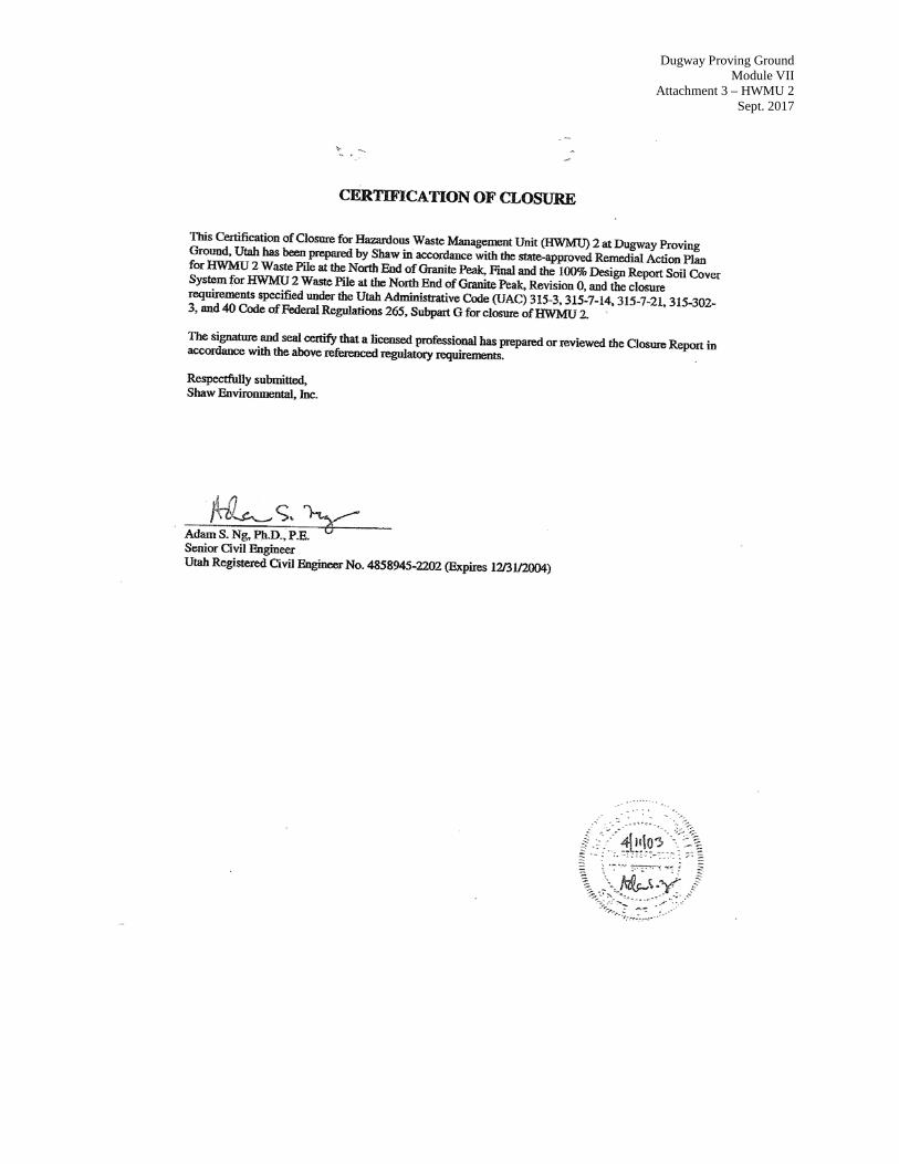
Appendix A Dugway, HWMU 2 Certificate of Closure
ii

Dugway Proving Ground Module VII
Attachment 3 – HWMU 2 Sept. 2017
1.0 INTRODUCTION
The objectives of the Hazardous Waste Management Unit (HWMU) 2 Post-Closure Plan (PCP) are: 1) ensure that Dugway Proving Ground (Dugway or DPG) complies with the Post-Closure Permit issued by the State of Utah in accordance with Utah Administrative Code (Utah Admin. Code) R315-265 - Title 40 Code of Federal Regulations (CFR) §265.117 incorporated by reference, with respect to post-closure inspections, care, and groundwater monitoring, and 2) prevent exposure to the buried landfill waste. To meet these objectives, this PCP provides detailed information regarding the location, regulatory criteria, inspections, and post-closure care and maintenance at HWMU 2. Post-closure care will ensure that the engineered soil cover at HWMU 2 is maintained and functions as designed. Post-closure care will continue for a minimum of 30 years after closure of HWMU 2. The post-closure care period may be extended or shortened, as deemed necessary Utah Admin. Code R315-265 (40 CFR §265.117(a)(2) incorporated by reference). Technical personnel conducting post-closure activities will be qualified personnel capable of performing the duties identified in this PCP and shall be in compliance with Permit Condition VII.L. In accordance with 40 CFR §270.28 and Utah Admin. Code R315-270-28, the post-closure permit is required to include specific information for a closed facility. As applicable to HWMU 2, the information requirements include:
1. General description of the facility;
2. Description of security procedures;
3. Copy of general inspection schedule;
4. Preparedness and Prevention Plan;
5. Facility location information
6. Closure Plan or Closure Proposal;
7. Certificate of Closure; and
8. Topographic map, with specific scale.
Table 1-1 provides the regulatory citations for the general information requirements and the specific locations in the Attachments or in the PCP where the specific information is presented.
Page 1

Dugway Proving Ground Module VII
Attachment 3 – HWMU 2 Sept. 2017
Table 1-1: Summary of HWMU 2 Post-Closure Information Requirements Under 40 CFR §270.14 and Utah Admin. Code R315-270-28 and R315-270-14
Regulation Citation Requirement Description Location Requirement is Addressed
40 CFR §270.14(b)(1)
Utah Admin. Code R315-270-14(b)(1)
General Description of the Facility
Post Closure Permit, Attachment 1
40 CFR §270.14(b)(4) Utah Admin. Code R315-270-14(b)(4)
Description of Security Procedures
Section 3.0.
40 CFR §270.14(b)(5) Utah Admin, Code R315-270-14(b)(5)
General Inspection Schedule Section 8.1, Module VII Table VII-3, and Module VII Form B
40 CFR §270.14(b)(6) Utah Admin. Code R315-270-14(b)(6)
Preparedness and Prevention Section 3.0
40 CFR §§270.14(b)(11)(i-ii, v) Utah Admin. Code R315-270-14(b)(11) (i-ii, v)
Facility Location Information
Applicable seismic standard
Attachment 1; Section 4.0.
40 CFR §§270.14(b)(11) (iii-v) Utah Admin. Code R315-270-14(b)(11) (iii-v)
Facility Location Information 100-year floodplain
Section 5.0
40 CFR §270.14(b)(14) Utah Admin. Code R315-270-14(b)(14)
Closure Certification and Notification
Appendix A
40 CFR §270.14(b)(16) Utah Admin. Code R315-270-14(b)(16)
Post-Closure Cost Estimate Federal Facilities are exempt from this requirement
40 CFR §270.14(b)(18) Utah Admin. Code R315-270-14(b)(18)
Proof of Financial Coverage Federal Facilities are exempt from this requirement
40 CFR §270.14(b)(19) Utah Admin. Code R315-270-14(b)(19) (i)
Topographic Map Map Scale and Date
Figure 2-4; 1 inch = 20 feet 2.5; 1 inch=1000’
40 CFR §270.14(b)(19) Utah Admin. Code R315-270-14(b)(19) (ii)
Topographic Map 100-year floodplain area
HWMU 2 is not located within a verified 100-year floodplain area (Figure 2-5).
40 CFR §270.14(b)(19) Utah Admin. Code R315-270-14(b)(19) (iii)
Topographic Map Surface waters including intermittent streams
There are no surface waters or intermittent streams within the HWMU 2 area (Figure 2-4).
40 CFR §270.14(b)(19) Utah Admin. Code R315-270-14(b)(19) (iv)
Topographic Map Surrounding land uses
HWMU 2 is within a military base. There are no nearby operations in the vicinity of HWMU 2. See Figure 2-4 & 2-5
40 CFR §270.14(b)(19) Utah Admin. Code R315-270-14(b)(19)
(v)
Topographic Map A wind rose (i.e., prevailing wind speed and direction)
The unit is closed with an engineered soil cover. There are no residential populations in the vicinity of HWMU 2. The closest residential area is English Village (approximately 30 miles away). A wind rose is not deemed necessary for HWMU 2.
40 CFR §270.14(b)(19) Utah Admin. Code R315-270-14(b)(19) (vi)
Topographic Map Orientation of Map, North Arrow
Figure 2-4 & 2-5
40 CFR §270.14(b)(19) Topographic Map The area is shown in Figure 2-4.
Page 2
Dugway Proving Ground Module VII
Attachment 3 – HWMU 2 Sept. 2017
Table 1-1: Summary of HWMU 2 Post-Closure Information Requirements Under 40 CFR §270.14 and Utah Admin. Code R315-270-28 and R315-270-14
Regulation Citation Requirement Description Location Requirement is Addressed
Utah Admin. Code R315-270-14(b)(19) (vii)
Legal boundaries of the hazardous waste management facility.
40 CFR §270.14(b)(19) Utah Admin. Code R315-270-14(b)(19) (viii)
Topographic Map Access control,
The area is shown in Figure 2-4.
40 CFR §270.14(b)(19) Utah Admin. Code R315-270-14(b)(19) (ix)
Topographic Map Injection and withdrawal wells
There are no injection or withdrawal wells in the vicinity of HWMU 2. The monitoring wells are shown in Figure 2-4.
40 CFR §270.14(b)(19) Utah Admin. Code R315-270-14(b)(19) (xi)
Topographic Map Barriers for drainage or flood control
The HWMU site is graded to drain away from the soil cover. Also, a drainage ditch was constructed on the southwest side of the site. See Figure 2-4
40 CFR §270.14(c) Utah Admin. Code R315-270-14(c)(1)
Groundwater Monitoring Information Summary of Groundwater Data
Section 2.4; HWMU 2 Closure Report Initial Groundwater Sampling 1995. Detection Program (four quarters) 1999-2000 (Utah Admin. Code R315-268). Assessment Program (4 semi-annual events) 2001-2002 (Utah Admin. Code R315-268) No additional post-closure groundwater monitoring is required at HWMU 2 (see Section 2.3.1.1 of the Downrange GMA)
40 CFR §270.14(c) Utah Admin Code R315-270-14(c)(2)
Groundwater Monitoring Information Identification of uppermost aquifer
Section 2.6; HWMU 2 Closure Report No additional post-closure groundwater monitoring is required at HWMU 2 (see Section 2.3.1.1 of the Downrange GMA)
40 CFR §270.14(c) Utah Admin. Code R315-270-14(c)(3)
Groundwater Monitoring Information Delineation of the Waste Management Area
Figure 2-5 ; HWMU 2 Closure Report includes the Legal Description for HWMU 2 No additional post-closure groundwater monitoring is required at HWMU 2 (see Section 2.3.1.1 of the Downrange GMA)
40 CFR §270.14(c) Utah Admin. Code R315-270- 14(c)(4)
Groundwater Monitoring Information
Extent of Plume
Section 2.4 includes a description of the groundwater data. There is no identified plume at HWMU 2. No additional post-closure groundwater monitoring is required at
Page 3

Dugway Proving Ground Module VII
Attachment 3 – HWMU 2 Sept. 2017
Table 1-1: Summary of HWMU 2 Post-Closure Information Requirements Under 40 CFR §270.14 and Utah Admin. Code R315-270-28 and R315-270-14
Regulation Citation Requirement Description Location Requirement is Addressed
HWMU 2 (see Section 2.3.1.1 of the Downrange GMA)
40 CFR §270.14(c) Utah Admin. Code R315-270-14(c)(5)
Groundwater Monitoring Information
Detailed Plans/Engineering Report for Proposed Groundwater Program
Section 2.0 No additional post-closure groundwater monitoring is required at HWMU 2 (see Section 2.3.1.1 of the Downrange GMA)
40 CFR §270.14(c) Utah Admin. Code R315-270-14(c)(6)(i)
Groundwater Monitoring Information
No Hazardous constituents are present in the groundwater at HWMU 2. Proposed List of Parameters
Section 2.0; HMWU 2 Closure Report No additional post-closure groundwater monitoring is required at HWMU 2 (see Section 2.3.1.1 of the Downrange GMA)
40 CFR §270.14(c) Utah Admin. Code R315-270-14(c)(6)(ii)
Groundwater Monitoring Information
No Hazardous constituents are present in the groundwater at HWMU 2.
Proposed Groundwater Monitoring System
No additional post-closure groundwater monitoring is required at HWMU 2 (see Section 2.3.1.1 of the Downrange GMA)
40 CFR §270.14(c) Utah Admin. Code R315-270-14(c)(6)(iii)
Groundwater Monitoring Information
No Hazardous constituents are present in the groundwater at HWMU 2 Background Values
No additional post-closure groundwater monitoring is required at HWMU 2 (see Section 2.3.1.1 of the Downrange GMA)
40 CFR §270.14(c) Utah Admin. Code R315-270-14(c)(6)(iv)
Groundwater Monitoring Information
No Hazardous constituents are present in the groundwater at HWMU 2. A description of the Proposed Sampling
No additional post-closure groundwater monitoring is required at HWMU 2 (see Section 2.3.1.1 of the Downrange GMA)
Page 4

Dugway Proving Ground Module VII
Attachment 3 – HWMU 2 Sept. 2017
2.0. HWMU 2 DESCRIPTION
The following provides a general description of HWMU 2, also known as the Waste Pile at the North End of Granite Peak at Dugway (Figure 2-1). The facility information requirements specified in Utah Admin. Code 315-270-14(d) for Solid Waste Management Units (SWMUs) is addressed under the Dugway Proving Ground Storage Permit. A general description of the Dugway installation can be found in Module VII, Attachment 1.
2.1 Location and History
HWMU 2, known as the Waste Pile at the North End of Granite Peak, is a closed HWMU located north of Granite Peak and approximately 1,000 feet (ft) north of Stark Road (Figure 2-5). Figure 2-2 shows the location of HWMU 2 with respect to Granite Peak. This HWMU is located on a relatively flat valley floor at an approximate elevation of 4,290 ft mean sea level (msl). The nearest operating Dugway facility is the Baker Area, located approximately 12 miles east of Granite Peak. The central portion of Dugway, in which HWMU 2 is located, is now primarily used for test ranges. In the past, munitions disposal, decontamination, and other demilitarization activities were also conducted in this portion of Dugway.
HWMU 2 was used for disposal of a variety of solid wastes generated during range cleanup and the demilitarization activities. The unit consisted of two unlined trenches that were positioned end to end and trend northwest-southeast (See Figure 2-3). These trenches were approximately 50 ft apart. Ridges of excavated soil that were four to six ft high were located adjacent to each trench on the east side. The northern trench was about 145 ft long, eight ft wide, and three ft deep, and the southern trench was approximately 110 ft long, 16 ft wide, and two to four ft deep. The central portion of the southern trench was backfilled with material from an adjacent pile of native soil to create a roadway across the trench for environmental sampling. A small drainage feature entered the southern end of the southern trench and another drainage feature exits the northern trench at the northern end. The northern half of the northern trench was vegetated with shrubs. Other features observed at HWMU 2 included a small area of burned material adjacent to the northern trench, which has since been excavated during closure activities.
2.2 Past Operation
HWMU 2 was used for disposal of a variety of solid wastes generated during range cleanup and the demilitarization activities. The unit may have also received biological agent laboratory wastes from Granite Peak Installation No. 2 (GPI-2), a former testing laboratory located 0.5 miles southeast of HWMU 2. According to a former Dugway employee, HWMU 2 had been in use since 1960. However, historical aerial photographs indicate the trenches were present in 1953. Disposal activities at HWMU 2 ceased prior to 1993 when a removal action was conducted at this unit.
During an October 1991 site visit, each trench was observed to be filled with debris from a maximum depth of five ft to within two to three ft of the ground surface. Backfill and eroded soil partially covered the debris. The wastes observed in the trenches at that time included miscellaneous trash, scrap metal, construction debris, asbestos cylinders, laboratory waste, empty decontamination solution containers, landing mats, ordnance-related debris, and potential 3X materials. Among these items was a 500- to 700-pound (lb) German bomb that previously contained Tabun (GA). The bomb had been bored and the agent drained from the bomb before it was placed in the northern trench. An expanded burster tube for chemical weapons was identified in the small excavation east of the southern trench. Spent o-
Page 5

Dugway Proving Ground Module VII
Attachment 3 – HWMU 2 Sept. 2017
chlorobenzalmalononitrile (CS) canisters, glass fragments, and light bulbs were identified on the surface near the two trenches.
In 1993, surface debris was removed from the trenches during a removal action. Approximately 4.9 tons of salvageable scrap was taken to the Defense Reutilization Management Office (DRMO) and the remaining 31 tons of surface debris were taken to the Dugway Landfill on Stark Road for disposal.
HWMU 2 was one of the 27 sites listed at Dugway under the Utah Department of Environmental Quality – Division of Solid and Hazardous Waste (UDEQ-DSHW) Stipulation and Consent Order No. 8909884 (dated September 19, 1990). This Consent Order directed Dugway to determine whether hazardous waste management occurred at these sites. This Stipulation and Consent Order was amended in December 22, 1993 and identified HWMU 2 among the sites to be closed. 2.3. Previous Investigations Documentation
Previous investigations at HWMU 2 have included geophysical, test pit, and soil investigations. Further details are included in the HWMU 2 Closure Report and in the Foster Wheeler Closure Plan (FWEC, 1998).
The detailed results of previous material, soil, and groundwater sampling, and closure information including the risk assessment are available, for HWMU 2 are provided in the Utah Division of Waste Management and Radiation Control (UDWMRC), formerly the Division of Solid and Hazardous Waste (DSHW), public documents listed in Table 2-1.
Table 2-1: Pertinent UDWMRC Library Documents Detailing HWMU 2 Investigations
Document Title Received Date UDWMRC Library No.
IT, 2001a. Final 100% Design Report for HWMU 2 Waste Pile at the North End of Granite Peak, Dugway Proving Ground, Dugway, U
6/1/2001 DSHW-2001-001724
IT, 2002. Final Groundwater Monitoring Work Plan and Sampling and Analysis Plan for the Consent Order Groundwater Monitoring Program, Dugway Proving Ground, Dugway, Utah, Revision 2.
4/19/02 DSHW-2002-003301
IT, 2003 Final Closure Report Hazardous Waste Management Unit (HWMU) 2; Waste Pile at North end of Granite Peak.
2/28/2003 DSHW-2003-009083
PES, 2007. Final Hydrogeological Assessment and Regional Groundwater Management Plan, Volume III: Downrange Groundwater Management Area. June.
6/2007 DSHW-2007-010344
2.4 Closure Activities
The closure of HWMU 2 has been completed. Approval for the HWMU 2 Closure Report (IT, 2003) was received in a letter dated from March 20, 2003, from Mr. Dennis R. Downs, Utah Solid and Hazardous
Page 6

Dugway Proving Ground Module VII
Attachment 3 – HWMU 2 Sept. 2017
Waste Control Board. Appendix A includes a copy of the HWMU 2 Closure Certification signed and stamped by a Utah-licensed Professional Engineer. In compliance with Utah Admin. Code R315-265, 40 CFR 265-111 incorporated by reference, the HWMU 2 closure provided a cover that will: 1) protect human health and the quality of the environment under conditions of continuing military use; 2) control, minimize, or eliminate the escape of hazardous constituents to soil, surface, groundwater, or the atmosphere during its closure and post-closure period; and 3) minimize the need for further maintenance. The final cover system (a two-ft thick engineered, soil cover with an additional rock protective layer) was designed and constructed to satisfy the requirements of these regulations namely:
1. Provide long-term minimization of migration of liquids through the closed landfill;
2. Function with minimum maintenance;
3. Promote drainage and minimize erosion or abrasion of the cover;
4. Accommodate settling and subsidence so that the cover’s integrity is maintained; and
5. Have a permeability less than or equal to the permeability of any bottom liner or natural subsoils present.
6. Major closure activities at HWMU 2 included:
7. Excavation and disposal of burn area soil to remove elevated arsenic and dioxins/furans concentrations and discolored burnt soil followed by confirmation sampling and backfilling;
8. Installation of an engineered soil cover;
9. Installation of a protective rock layer over the engineered soil cover; and
10. Upgrade of the existing access road, grading, and erosion control activities to minimize long-term maintenance requirements.
11. The final closure cover system consisted of the following components (from bottom to top):
12. A minimum one-foot thick layer of self-compacting fill;
13. A compacted subgrade layer comprised of clean soil imported from the Dugway landfill;
14. An 18-inch thick layer of controlled permeability (permeability range of 1 x 10⁻⁴ centimeters per second (cm/sec) to 1 x 10⁻⁶ cm/sec); and
15. A 6-inch thick layer of soil cover overlain by a protective rock layer.
All construction activities were completed in accordance with applicable Utah Admin. Code regulations, the Remedial Action Plan, the 100% Design Report, and approved Field Work Variances (FWVs). Figure 2-4 shows the post-closure configuration of the HWMU 2 engineered soil cover and existing site conditions.
Page 7

Dugway Proving Ground Module VII
Attachment 3 – HWMU 2 Sept. 2017
All the permeability tests conducted on the 18-inch thick controlled permeability layer passed the established criterion of 1 x 10⁻⁴ cm/sec to 1 x 10⁻⁶ cm/sec. After completion of the 18-inch thick low permeability layer, the 6-inch thick soil layer was installed in a single lift using the same source of import material from the Dugway Landfill. This final lift (vegetated layer) was then drill-seeded. The selected vegetation is in compliance with the Forage and Conservation Planting Guide for Utah (EC433) developed by the Cooperative Extension Service of Utah State University (Utah State University, 1989) and appropriate for arid environments. As vegetation did not take, a protective rock layer was placed over the final soil layer to ensure cover integrity.
Other construction activities included construction of a swale and other miscellaneous grading around the landfill, installation of appropriate signage around the engineered soil cover, upgrading the existing road for access during the rainy season, adding a final protective rock layer over the disturbed areas of the engineered soil cover, and seeding outside of the cover area. As part of general grading efforts, drainage along the east side of the former dirt road was redirected to the west side of the road by construction of a swale. The swale has a maximum depth of six inches. General grading was also completed to fill low-lying areas around the southern and eastern sides of the soil cover to prevent precipitation from running onto the soil cover. The road improvements consisted of upgrading the existing dirt road. The cross section of the roadway as designed and constructed is approximately 12 ft wide and eight inches thick with a two-percent crown along the centerline of the roadway. Final lines and grades were surveyed for as-built documentation purposes.
2.4.1 Post Closure Regulatory Basis
Utah has specific regulations governing the closure and post-closure requirements for interim status hazardous waste treatment, storage and disposal facilities (TSDFs) (Utah Admin. Code R315-265 40 CFR §265.110 – 265.121 incorporated by reference). Post-Closure groundwater monitoring requirements must comply with requirements specified in Utah Admin. Code R315-265 (40CFR §265- 90 -265 94 incorporated by reference) and R315-265 (40 CFR §265-110 – 265-121 incorporated by reference)(40 CFR §265 subparts F (Groundwater Monitoring) and subpart G (Closure and Post-closure Care respectively. In accordance with Utah Admin. Code R315-265 (40 CFR §265-310(b) incorporated by reference), the following are the requirements for post-closure care:
1. After final closure, the owner or operator shall comply with all post-closure
requirements contained in Utah Admin. Code R315-265, which incorporates by reference 40 CFR §§265.110 - 265.120, including maintenance and monitoring throughout the post-closure care period. The owner or operator shall:
2. Maintain the integrity and effectiveness of the final cover, including making repairs to the cover as necessary to correct the effects of settling, subsidence, erosion, or other events;
3. Maintain and monitor the leak detection system in accordance with Utah Admin. Code R315-264-301(c)(3)(iv) and (4) and R315-265 (40 CFR 265-340(b)), and comply with all other applicable leak detection system requirements of Utah Admin. Code R315-265. The HWMU 2 engineered soil cover is exempt from this requirement because it qualifies as an “existing unit” exempt from the minimum requirements imposed by Hazardous and Solid Waste Agency (HSWA) for new landfills.
Page 8
Dugway Proving Ground Module VII
Attachment 3 – HWMU 2 Sept. 2017
4. Maintain and monitor the groundwater monitoring system and comply with all other applicable requirements of Utah Admin. Code R315-265 (40 CFR 265-90 – 265-94 incorporated by reference). HWMU 2 is exempt from this requirement as additional groundwater monitoring at HWMU 2 is not required (PES, 2007);
5. Prevent run-on and run-off from eroding or otherwise damaging the final cover; and
6. Protect and maintain surveyed benchmarks used in complying with Utah Admin. Code R315-265 (40 CFR §265-309 incorporated by reference).”
Based on the work performed at HWMU 2 and the risk evaluations presented in the Final Closure Report, the requirements specified under 40 CFR §265, subpart G and a Consent Order have been achieved.
The detailed results of previous material, soil, and groundwater sampling at HWMU 2 are included in the. Draft Final Closure Report for HWMU 2 Waste Pile at the North End of Granite Peak (Closure Report), Dugway Proving Ground, Dugway, Utah (IT, 2003b).
The closure of HWMU 2 has been completed. Approval for the HWMU 2 Final Remedial Action Closure Report (IT, 2003) was received in a letter dated March 20, 2003, from Mr. Dennis R. Downs, Utah Solid and Hazardous Waste Control Board. Appendix A includes a copy of the HWMU 2 Closure Certification signed and stamped by a Utah-licensed Professional Engineer. UDSHW verified the Closure of HWMU 2 on August 4, 2003. With the investigative, remedial, and closure actions performed at this site, all stipulations of the Consent Order has been satisfied for HWMU 2.
2.5 Groundwater Four shallow groundwater monitoring wells (MW01, MW02, MW03, and MW04) were installed at HWMU 2. Sampling of these wells since 1995 has resulted in no data indicating a release to groundwater at HWMU 2. Groundwater is also classified as non-potable.
According to the downrange GMA no additional post closure groundwater monitoring is required at HWMU 2.
2.6 Closure Notifications
Federal facilities are exempt from submitting notifications to the local zoning authority as required by Utah Admin. Code R315-264-116 and R315-264-119. 3.0 SECURITY AND CONTINGENCY REQUIREMENTS The Permittee shall comply with the following security conditions as applicable to HWMU 2:
1. HWMU 2 is located within a federal, military installation (Dugway). As such, the installation is restricted for the common population. Access to HWMU 2 is strictly monitored by Dugway Base Security (Range Control).
2. Signs, which read “DANGER, UNAUTHORIZED PERSONNEL KEEP OUT”, are posted every 50 ft along the perimeter of the unit and shall be maintained throughout the post-closure care period. The signs must be legible from a distance of at least 25 ft in compliance with Utah Admin. Code R3l5-264-14(c).
Page 9

Dugway Proving Ground Module VII
Attachment 3 – HWMU 2 Sept. 2017
3. All security equipment shall be inspected throughout the post-closure care period. The Permittee shall incorporate those security items (i.e., warning signs, signs of vandalism, etc.) to be inspected and the frequency of inspection on the inspection schedule.
4. Damaged security equipment shall be noted in the inspection checklist. Repairs shall be completed as soon as practicable after the problem is discovered, in compliance with Utah Admin. Code R3l5-264-15(c).
3.1. Contingency Plan
This section provides information about emergency response inspection procedures to be implemented in the event of any natural disaster in the Dugway area that may affect the soil cover at HWMU 2. Module VII, Form B addresses post-closure site inspections.
The Dugway Emergency Response and Contingency Plan (Part B Permit), where applicable to this site, shall be used to announce and respond to emergency conditions. At a minimum, the site inspector should have a radio or phone and a First Aid kit available during inspections.
3.1.1. Earthquakes
Dugway is located in Seismic Zone 2 with a maximum acceleration of 0.16 gravity force (IT, 2001a). In the event of a 6.5-magnitude or higher earthquake centered within 50 miles of the site, qualified personnel will visually inspect the landfill cap for signs of damage as soon as it is safe and practical to do so. Any damage to the landfill cap will be repaired to ensure the integrity of the cap. If the landfill cap has sustained extensive damage, Dugway will implement corrective actions to ensure that contaminants are contained and human health is protected. Post-earthquake site inspection records will be submitted to the Dugway Environmental Department.
Following an earthquake, the landfill and landfill cap will also be inspected for lateral shifting of debris. Settlement markers will be resurveyed to determine any horizontal or vertical movement of the cap.
3.1.2. Floods or Major Storms
In the event of a flood or major storm, Dugway will inspect the landfill cap to ensure its integrity within 72 business hours of the event. A post-closure site inspection checklist is included as Form B in Module VII. A major storm is defined in this plan as a storm with one inch of precipitation or more over a 24-hour period. Any damage to the landfill cap will be repaired as soon as possible to ensure the integrity of the cap.
3.1.3. Fire
The event of a fire is an unlikely event at HWMU 2 given its remote location with respect to other base facilities. Nonetheless, in the event of a surface fire near the landfill cap, the Dugway fire department will be notified and the Dugway integrated contingency plan will be implemented. In the event of a landfill fire, if the cap is observed to have been breached, other firefighting methods (such as using foam or smothering with dirt) will be considered and used, as appropriate. Following the incident, Dugway will perform a thorough inspection of the landfill cap using the site-specific post-closure emergency response checklist included in Form Bin Module VII, to ensure that the integrity of the soil cover has not
Page 10

Dugway Proving Ground Module VII
Attachment 3 – HWMU 2 Sept. 2017
been compromised and waste is not exposed. If there is fire damage, Dugway will implement corrective actions to ensure that contaminants are contained and human health is protected.
4.0. SEISMIC STANDARD
HWMU 2 is not located within 200 ft of faults, which have displacement in Holocene time. Although, Utah is tectonically active, most of the earthquake activity occurs about 55 miles to the east along the Wasatch Range Foothills. The U.S. Geological Survey has conducted a study ([U.S. Geological Survey (USGS), 1988]. Map of Fault Scarps Formed on Unconsolidated Sediments, Tooele 1°x2° Quadrangle, Northwestern Utah. Compiled by T.P. Bamhard and R. L. Dodge) to determine the distribution, relative age, and amount and extent of surface rupture on Quaternary fault scarps in the Tooele 1x2 Quadrangle in northwestern Utah. The conclusions of the study state that morphologic and geologic data collected along the fault scarps in the area indicate that all were formed during the later Pleistocene era with no clear evidence of Holocene surface faulting. Several faults inferred on geophysical evidence are located on Dugway; however, there is no evidence of displacement during Holocene time.
5.0. FLOODPLAIN STANDARD HWMU 2 is not located within a 100-year verified floodplain. A National Flood Insurance Rate Map, identifying the boundary of the 100-year flood, has not been prepared for Dugway. These are no permanent streams or other surface water bodies on Dugway. Surface water from precipitation flows through well-established drainage channels into the flat plain and evaporates. Like other arid regions, Dugway is subject to flash flooding following high-precipitation events. Flash floods have occurred only four times in the history of the installation, in 1944, 1952, 1973, and 1983. The major area affected during flash floods has been the Government Creek drainage channel, which has overflowed and caused minor inundation of roads at Ditto Technical Center. HWMU 2 is located at the north end of Granite Peak, approximately 20 miles from the Ditto Technical Center. Because of the location of HWMU 2, it is not likely that a 100-year flood would affect the site.
The area around HWMU 2 has been graded to divert surface water away from the engineered soils covers. In addition, a swale was constructed along the southern edge of the site to diver runoff coming from Stark road (Figure 2-4).
6.0 POST-CLOSURE OPERATIONS, MAINTENANCE AND REPORTING
The HWMU 2 waste pile has been covered with an engineered soil cover. The following sections discuss the Operation and Maintenance (O&M) procedures and the Reports required to ensure maintenance and monitoring of the engineered soil cover during the post-closure period.
6.1 Site Inspections
General site inspections of the landfill area will be conducted annually by November 1st to ensure that the integrity of the landfill cap is maintained. The following post-closure inspections will be required:
1. General site inspections; 2. Rock cover inspections; and
Page 11

Dugway Proving Ground Module VII
Attachment 3 – HWMU 2 Sept. 2017
3. Soil Erosion Control inspections.
Post-closure site inspections will be conducting using Form B of Module VII for documenting the above required inspections. 6.1.1. General Inspection
The site shall be visually inspected to ensure the following conditions are maintained at the site:
1. Proper warning signs are present; 2. No weeds (with deep taproots) are present that may penetrate the cap; 3. No excessive soil erosion is evident on the cap surface or at the cap edges; 4. No noticeable damage to the soil covering from burrowing animals; 5. No excessive vegetation is growing in the swale drainage ditch; 6. No noticeable depressions or ponded water are present; 7. No noticeable sliding (slope failure) or desiccation cracks are present in the soil cover; and 8. No excessive erosion of the all-weather road accessing and surrounding the HWMU 2 soil
cover is evident.
As part of the routine inspection, settlement marker locations and elevations should be surveyed at least once every six months for the first year after construction, and annually thereafter. When a settlement of 0.1 foot or less has been measured for two consecutive years, surveys can be scaled back to once every five years. The baseline northings, eastings (State Plan, Nad 83 Central Zone), and elevations of the settlement markers are summarized in the table below.
Table 6-1: Surveyed Coordinates for HWMU 2 Settlement Markers.
Type Location Northing (ft) Easting (ft) Elevation
(ft above msl)
Settlement Marker (SM-1) South end of soil cover 7237846.49 1136002.64 4283.56
Settlement Marker (SM-2) North end of soil cover 7238035.42 1135922.90 4284.73
6.1.2 Soil Erosion Control Inspection
The surface water control system should be inspected to ensure that it is providing adequate erosion control. The HWMU-2 post-closure site inspection form for landfill sites (Form B) in Module VII includes procedures for ensuring that soil erosion is controlled.
If signs of soil erosion are excessive (for example, cracks or rills greater than two inches wide) and continual (recurring in the same area), corrective action may be needed. Significant cracks and/or rills that have the potential to impact the functionality of the cover system will be documented in the
Page 12

Dugway Proving Ground Module VII
Attachment 3 – HWMU 2 Sept. 2017
inspection forms. Corrective actions may include filling in the eroded or cracked area, investigating the cause of erosion, and regrading slopes.
6.1.3 Corrective Action
Corrective action shall be initiated as soon as practical but no longer than 30 days of discovery. If the corrective action will require more than 30 days a schedule of the correction will be provided to the Director for approval. If the corrective action requires substantial effort, a technical plan shall be prepared to summarize the problem, illustrate potential impacts, and clarify the proposed plan for action. Routine corrective actions will be recorded on the site inspection form in the comments with the date of the correction. This will ensure proper tracking of the resolution.
Table 6-2: HWMU 2 Post-Closure Inspection and Monitoring Schedule.
Inspection/Monitoring Item
Frequency of Inspection (To be documented on the General Landfill Inspection Form, Module VII Form B)
Soil Cover Inspection: cover integrity rock cover/erosion settlement subsidence surface water drainage systems
Annual Inspection due by November 1st. An additional inspection shall be required after a major rain event.
Settlement Marker Survey Annual Surveys shall be conducted once every five years.
Signs Annual Access Road Annual Well monuments (damage, oxidation) Annual
Exposed well casing (structural integrity, cracks, & corrosion) and well caps. Well id markers, surface pads, and dedicated wells.
Annual
Emergency Response (earthquake, storms, fire) As soon as possible after an earthquake
or major storm
6.1.4 Inspection Follow-Up
All copies of completed site inspection checklists (Form B, Module VII) will be forwarded to the Dugway Environmental Office. If significant damage or erosion is observed, the Dugway Environmental Office will be contacted immediately by telephone. The Point-of-Contact for the Dugway Environmental Office is as follows:
Page 13

Dugway Proving Ground Module VII
Attachment 3 – HWMU 2 Sept. 2017
Environmental Programs Compliance Representative Dugway Environmental Program Office Dugway Proving Ground, UT 84022 (435) 831-3560
Corrective action shall be initiated as soon as practical but no longer than 30 days of discovery. If the corrective action will require more than 30 days a schedule of the correction will be provided to the Director for approval. If the corrective action requires substantial effort, a technical plan shall be prepared to summarize the problem, illustrate potential impacts, and clarify the proposed plan for action. Routine corrective actions will be recorded on the site inspection form in the comments with the date of the correction. This will ensure proper tracking of the resolution. 6.2 Reporting This section summarizes the reporting requirements for HWMU 2 during the post-closure period (Table 6-3). 6.2.1. Non-Compliance In the event a non-compliant issue is observed at HWMU 2, which may endanger public water supplies, human health, or the environment, the Dugway Environmental Office shall be notified immediately. Dugway will notify the Director orally within 24 hours. A written notification will be submitted to UDEQ-DWMRC within five days after oral notification with a planned corrective action or within 15 days if the Director waives the five-day notification. If the non-compliance does not affect human health or the environment, the written notification will be submitted at the time monitoring reports are submitted (Utah Admin. Code R315-270-30(l)(2)(ii)(4). At a minimum, the following information will be provided:
1. Name, address, and telephone number of the Permittee; 2. Name, address, and telephone number of individual making the report; 3. Date, time, and type of incident; 4. Description and quantity of materials involved; 5. The extent of injuries or damage (if any); 6. An assessment of actual or potential hazard to the environment and health outside the facility;
and 7. Estimated quantity and disposition of recovered materials.
The remote site conditions at HWMU 2 are such that impacts to human health outside the site itself are very unlikely. HWMU 2 is located in a very remote part of a controlled federal facility. Hazardous materials are no longer managed or maintained at the site. Nonetheless, if there is any type of non-compliance, the above requirements apply.
Page 14
Dugway Proving Ground Module VII
Attachment 3 – HWMU 2 Sept. 2017
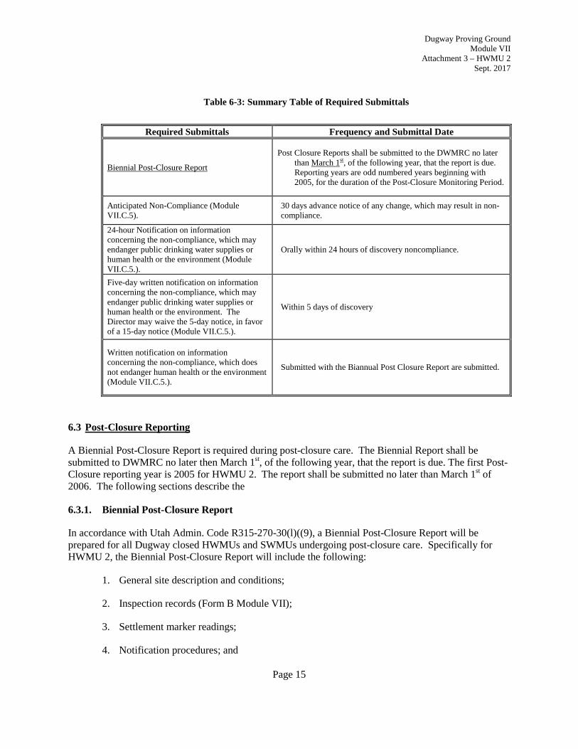
Table 6-3: Summary Table of Required Submittals
Required Submittals Frequency and Submittal Date
Biennial Post-Closure Report
Post Closure Reports shall be submitted to the DWMRC no later than March 1st, of the following year, that the report is due. Reporting years are odd numbered years beginning with 2005, for the duration of the Post-Closure Monitoring Period.
Anticipated Non-Compliance (Module VII.C.5).
30 days advance notice of any change, which may result in non-compliance.
24-hour Notification on information concerning the non-compliance, which may endanger public drinking water supplies or human health or the environment (Module VII.C.5.).
Orally within 24 hours of discovery noncompliance.
Five-day written notification on information concerning the non-compliance, which may endanger public drinking water supplies or human health or the environment. The Director may waive the 5-day notice, in favor of a 15-day notice (Module VII.C.5.).
Within 5 days of discovery
Written notification on information concerning the non-compliance, which does not endanger human health or the environment (Module VII.C.5.).
Submitted with the Biannual Post Closure Report are submitted.
6.3 Post-Closure Reporting
A Biennial Post-Closure Report is required during post-closure care. The Biennial Report shall be submitted to DWMRC no later then March 1st, of the following year, that the report is due. The first Post-Closure reporting year is 2005 for HWMU 2. The report shall be submitted no later than March 1st of 2006. The following sections describe the
6.3.1. Biennial Post-Closure Report
In accordance with Utah Admin. Code R315-270-30(l)((9), a Biennial Post-Closure Report will be prepared for all Dugway closed HWMUs and SWMUs undergoing post-closure care. Specifically for HWMU 2, the Biennial Post-Closure Report will include the following:
1. General site description and conditions;
2. Inspection records (Form B Module VII);
3. Settlement marker readings;
4. Notification procedures; and
Page 15
Dugway Proving Ground Module VII
Attachment 3 – HWMU 2 Sept. 2017
5. Maintenance/Repairs performed.
7.0 POST-CLOSURE CERTIFICATION
No later than 60 days after post-closure activities are completed and approved by the Director, Dugway will submit a certification to the Board, signed by Dugway and an independent professional engineer registered in the State of Utah, stating why post-closure care is no longer needed.
Page 16

Dugway Proving Ground Module VII
Attachment 3 – HWMU 2 Sept. 2017
8.0 REFERENCES
AGEISS Environmental (AGEISS), 1996. Comprehensive Groundwater Monitoring Plan. July. AGEISS, 1998c. Final Annual Groundwater Monitoring Report for Execution of the Groundwater Monitoring Plan for the Consent Order Hazardous Waste Management Units. November. Department of Defense (DOD), 2002. Quality Systems Manual for Environmental Laboratories, Final Version 2. June. Dugway Proving Ground RCRA Part B Permit Foster Wheeler, Environmental Corporation (FWEC), 1996. Dugway Proving Ground Closure Plan Module 3. September. FWEC, 1998. Dugway Proving Ground Closure Module 3, HWMU 2. May. ICF Kaiser Engineers (ICF Kaiser), 1998. Program Contractor Quality Control Plan for Sacramento TERC II, USACE Contract No. DACW05-96—D-001, Revision. November. IT Corporation (IT), 2003a. Draft Fiscal Year 2002 Annual Report, Dugway Groundwater Monitoring Program, Dugway Proving Ground, Dugway, Utah. March. IT, 2003b. Draft Final Closure Report for HWMU 2 Waste Pile at the North End of Granite Peak (Closure Report), Dugway Proving Ground, Dugway, Utah. February. IT, 2002. Final Groundwater Monitoring Work Plan and Sampling and Analysis Plan for the Detection and Assessment Monitoring Program, Dugway Proving Ground, Dugway, Utah, Revision 2. March. IT, 2001a. Final 100% Design Report for HWMU 2 Waste Pile at the North End of Granite Peak, Dugway Proving Ground, Dugway, Utah. September. IT, 2001b. Final Remedial Action Plan for HWMU 2 Waste Pile at the North End of Granite Peak, Dugway Proving Ground, Dugway, Utah. September. IT, 2000a. Fiscal Year 2000 Annual Report, Dugway Groundwater Monitoring Program, Dugway Proving Ground, Dugway, Utah. December. IT, 2000b. 1999 Annual Report, Dugway Groundwater Monitoring Program, Final, Dugway Proving Ground, Dugway, Utah. February. IT, 2000c. Chemical Data Quality Management Plan for Dugway Proving Ground, Dugway, Utah. Revision 2. June. Parsons Engineering Science (PES). 2002a. Final Phase II RCRA Facility Investigation Risk Assumptions Document, Revision 2, Dugway Proving Ground, Dugway Utah. May. PES, 2002b. Draft Hydrogeological Assessment and Regional Groundwater Management Plan. September.
Page 17

Dugway Proving Ground Module VII
Attachment 3 – HWMU 2 Sept. 2017
PES, 2007. Final Hydrogeological Assessment and Regional Groundwater Management Plan, Volume III: Downrange Groundwater Management Area. June. U.S. Environmental Protection Agency (USEPA), 1997. Solid Waste and Emergency Response, “IDENTIFYING YOUR WASTE, THE STARTING POINT,” USEPA530-F-97-029, http://www.epa.gov). September. USEPA, 1994, February. U.S. Environmental Protection Agency Contract Laboratory Program National Functional Guidelines for Organic Data Review (PB94-963501) and U.S. Environmental Protection Agency Contract Laboratory Program National Functional Guidelines For Inorganic Data Review (PB94-963502). February. USEPA, 1990. USEPA v. Environmental Waste Control, Inc., 710 F. Supp. 1172, 1214-1216 (1989), aff’d., 917 F.2d 327 (7th Cir. 1990)). U.S. Geological Survey (USGS), 1954. Dugway Proving Ground, Southeast Utah. Quadrangle. 1:24,000. USGS, 1993a. Topographic Map, Camels Back Ridge, NW Quadrangle. 7.5 Minute Series. Dugway, Utah. USGS, 1993b. Topographic Map, Camels Back Ridge, NE Quadrangle. 7.5 Minute Series. Dugway, Utah. Utah Administrative Code , Utah Hazardous Waste Management Rules, R315-265 to R315-266, R315-50, and R315-101. Utah State University, 1989. Forage and Conservation Planting Guide for Utah (EC433).
Page 18

APPENDIX A
COPY OF CERTIFICATION OF CLOSURE
Dugway Proving Ground Module VII
Attachment 3 – HWMU 2 Sept. 2017