Embed Size (px)
Citation preview
Cameron’s Run
January 2017 1
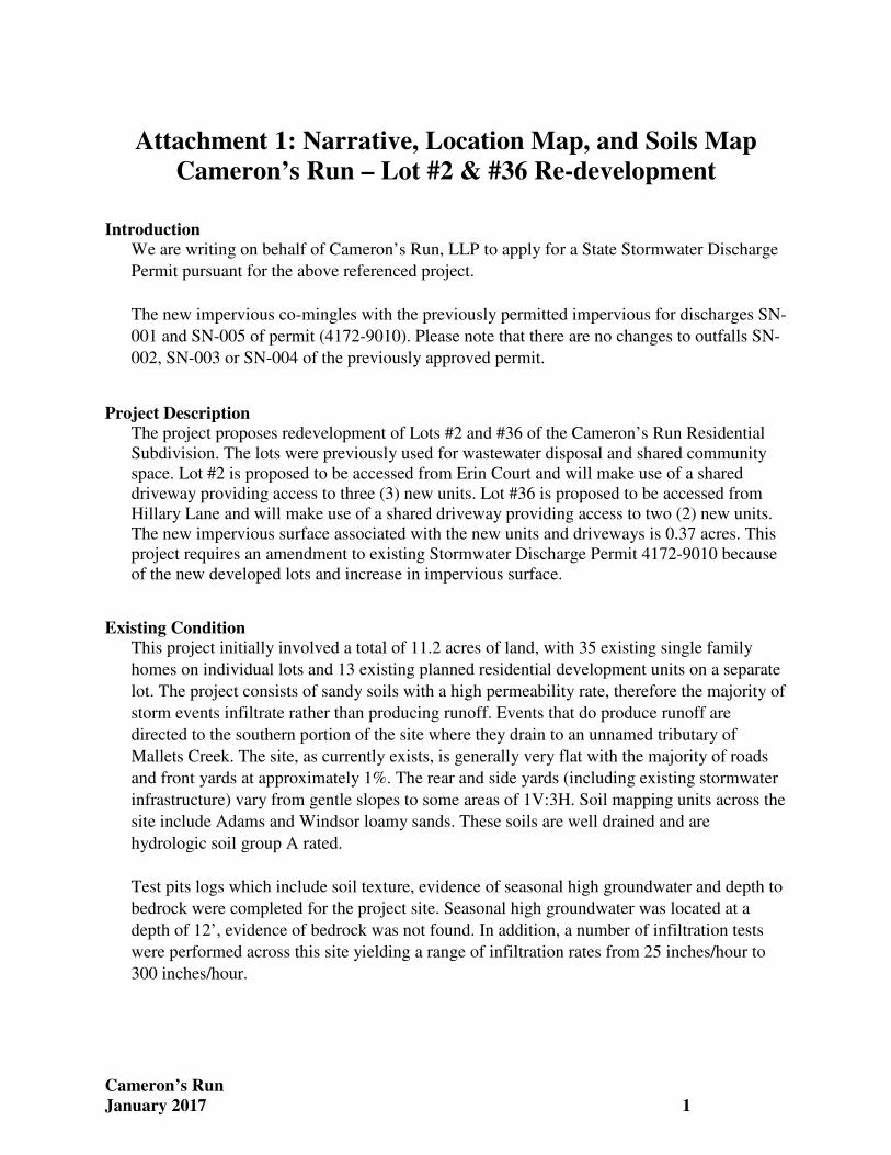
Attachment 1: Narrative, Location Map, and Soils Map
Cameron’s Run – Lot #2 & #36 Re-development
Introduction We are writing on behalf of Cameron’s Run, LLP to apply for a State Stormwater Discharge
Permit pursuant for the above referenced project.
The new impervious co-mingles with the previously permitted impervious for discharges SN-
001 and SN-005 of permit (4172-9010). Please note that there are no changes to outfalls SN-
002, SN-003 or SN-004 of the previously approved permit.
Project Description The project proposes redevelopment of Lots #2 and #36 of the Cameron’s Run Residential
Subdivision. The lots were previously used for wastewater disposal and shared community
space. Lot #2 is proposed to be accessed from Erin Court and will make use of a shared
driveway providing access to three (3) new units. Lot #36 is proposed to be accessed from
Hillary Lane and will make use of a shared driveway providing access to two (2) new units.
The new impervious surface associated with the new units and driveways is 0.37 acres. This
project requires an amendment to existing Stormwater Discharge Permit 4172-9010 because
of the new developed lots and increase in impervious surface.
Existing Condition This project initially involved a total of 11.2 acres of land, with 35 existing single family
homes on individual lots and 13 existing planned residential development units on a separate
lot. The project consists of sandy soils with a high permeability rate, therefore the majority of
storm events infiltrate rather than producing runoff. Events that do produce runoff are
directed to the southern portion of the site where they drain to an unnamed tributary of
Mallets Creek. The site, as currently exists, is generally very flat with the majority of roads
and front yards at approximately 1%. The rear and side yards (including existing stormwater
infrastructure) vary from gentle slopes to some areas of 1V:3H. Soil mapping units across the
site include Adams and Windsor loamy sands. These soils are well drained and are
hydrologic soil group A rated.
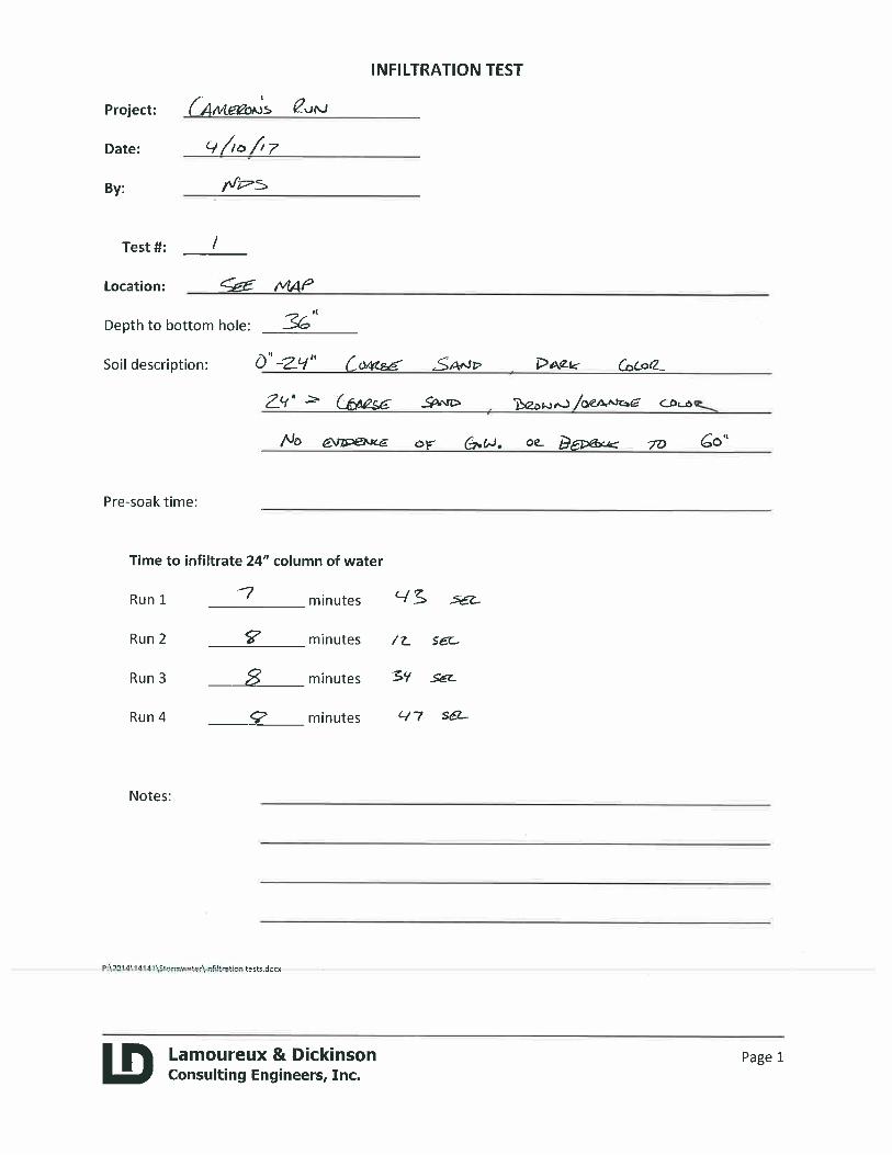
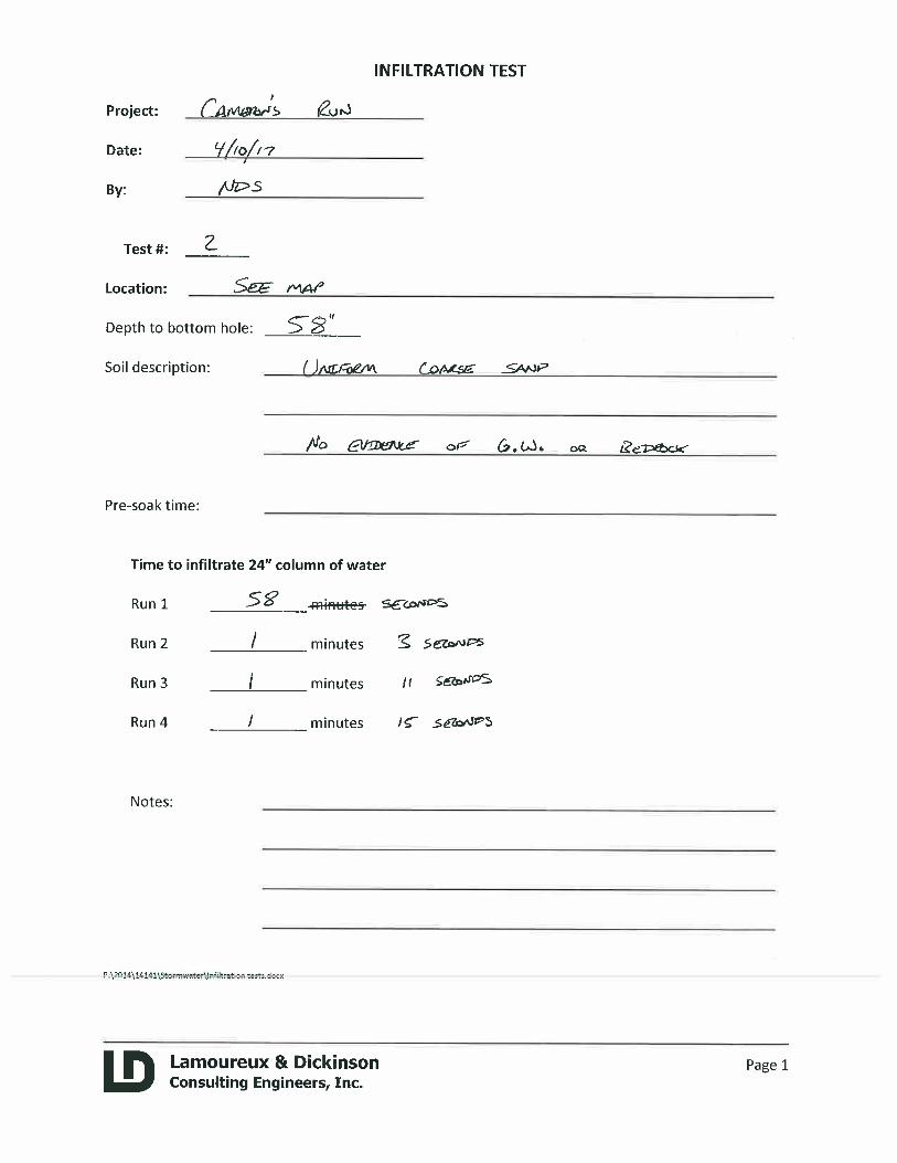
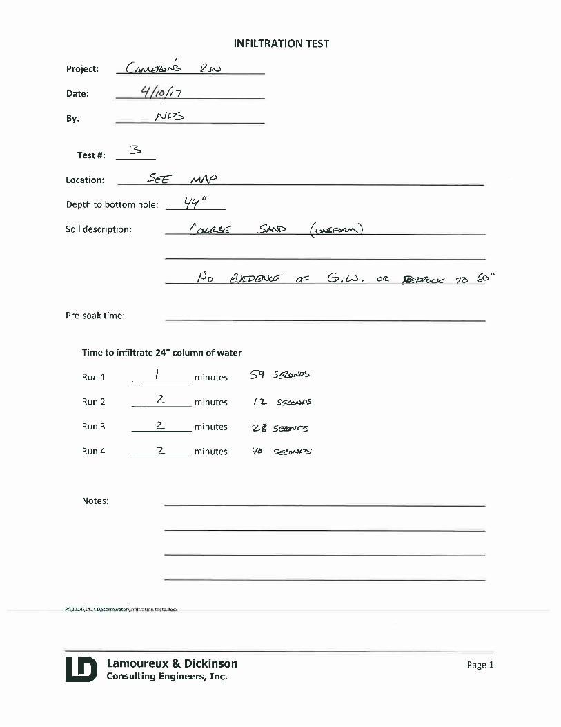
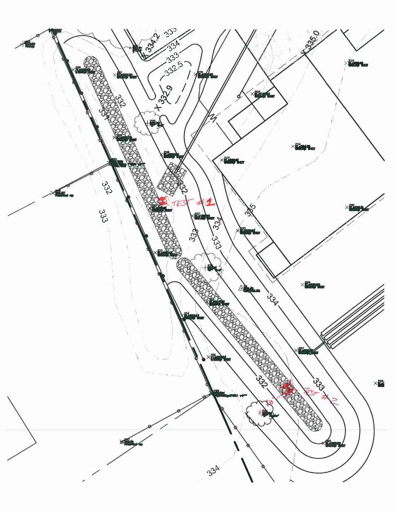
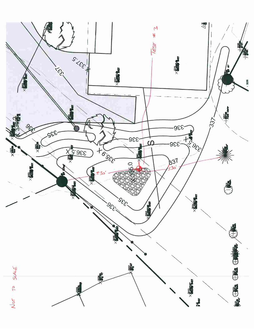
Test pits logs which include soil texture, evidence of seasonal high groundwater and depth to
bedrock were completed for the project site. Seasonal high groundwater was located at a
depth of 12’, evidence of bedrock was not found. In addition, a number of infiltration tests
were performed across this site yielding a range of infiltration rates from 25 inches/hour to
300 inches/hour.
Cameron’s Run
January 2017 2
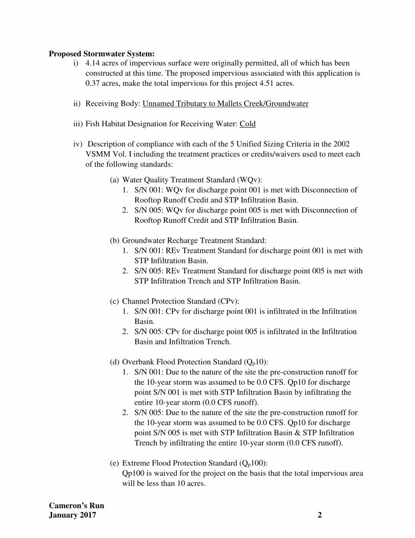
Proposed Stormwater System: i) 4.14 acres of impervious surface were originally permitted, all of which has been
constructed at this time. The proposed impervious associated with this application is
0.37 acres, make the total impervious for this project 4.51 acres.
ii) Receiving Body: Unnamed Tributary to Mallets Creek/Groundwater
iii) Fish Habitat Designation for Receiving Water: Cold
iv) Description of compliance with each of the 5 Unified Sizing Criteria in the 2002
VSMM Vol. I including the treatment practices or credits/waivers used to meet each
of the following standards:
(a) Water Quality Treatment Standard (WQv):
1. S/N 001: WQv for discharge point 001 is met with Disconnection of
Rooftop Runoff Credit and STP Infiltration Basin.
2. S/N 005: WQv for discharge point 005 is met with Disconnection of
Rooftop Runoff Credit and STP Infiltration Basin.
(b) Groundwater Recharge Treatment Standard:
1. S/N 001: REv Treatment Standard for discharge point 001 is met with
STP Infiltration Basin.
2. S/N 005: REv Treatment Standard for discharge point 005 is met with
STP Infiltration Trench and STP Infiltration Basin.
(c) Channel Protection Standard (CPv):
1. S/N 001: CPv for discharge point 001 is infiltrated in the Infiltration
Basin.
2. S/N 005: CPv for discharge point 005 is infiltrated in the Infiltration
Basin and Infiltration Trench.
(d) Overbank Flood Protection Standard (Qp10):
1. S/N 001: Due to the nature of the site the pre-construction runoff for
the 10-year storm was assumed to be 0.0 CFS. Qp10 for discharge
point S/N 001 is met with STP Infiltration Basin by infiltrating the
entire 10-year storm (0.0 CFS runoff).
2. S/N 005: Due to the nature of the site the pre-construction runoff for
the 10-year storm was assumed to be 0.0 CFS. Qp10 for discharge
point S/N 005 is met with STP Infiltration Basin & STP Infiltration
Trench by infiltrating the entire 10-year storm (0.0 CFS runoff).
(e) Extreme Flood Protection Standard (Qp100):
Qp100 is waived for the project on the basis that the total impervious area
will be less than 10 acres.
Cameron’s Run
January 2017 3
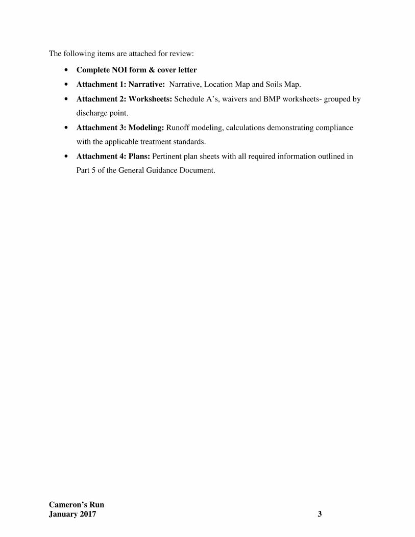
The following items are attached for review:
• Complete NOI form & cover letter
• Attachment 1: Narrative: Narrative, Location Map and Soils Map.
• Attachment 2: Worksheets: Schedule A’s, waivers and BMP worksheets- grouped by
discharge point.
• Attachment 3: Modeling: Runoff modeling, calculations demonstrating compliance
with the applicable treatment standards.
• Attachment 4: Plans: Pertinent plan sheets with all required information outlined in
Part 5 of the General Guidance Document.
30,000
1,524.0
Natural Resources AtlasVermont Agency of Natural Resources
19,650
© Vermont Agency of Natural Resources
998.0
1:
WGS_1984_Web_Mercator_Auxiliary_Sphere
Meters998.00
NOTES
Map created using ANR's Natural Resources Atlas
LEGEND
499.00
vermont.gov
DISCLAIMER: This map is for general reference only. Data layers that appearon this map may or may not be accurate, current, or otherwise reliable. ANR and
the State of Vermont make no representations of any kind, including but notlimited to, the warranties of merchantability, or fitness for a particular use, nor
are any such warranties to be implied with respect to the data on this map.
December 16, 2016
THIS MAP IS NOT TO BE USED FOR NAVIGATION
1" = 1638 1cm = 196Ft. Meters
Waterbody
Stream
Parcels (where available)
Town Boundary
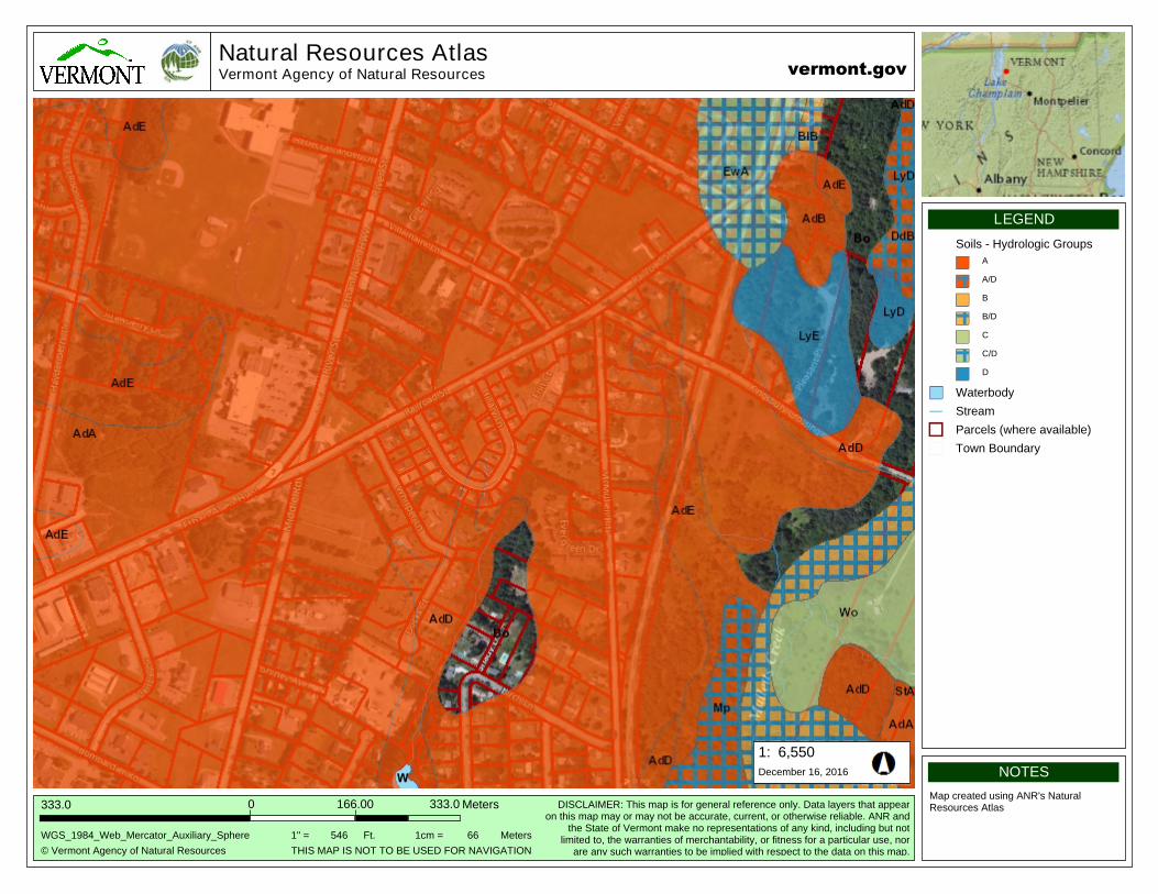
10,000
508.0
Natural Resources AtlasVermont Agency of Natural Resources
6,550
© Vermont Agency of Natural Resources
333.0
1:
WGS_1984_Web_Mercator_Auxiliary_Sphere
Meters333.00
NOTES
Map created using ANR's Natural Resources Atlas
LEGEND
166.00
vermont.gov
DISCLAIMER: This map is for general reference only. Data layers that appearon this map may or may not be accurate, current, or otherwise reliable. ANR and
the State of Vermont make no representations of any kind, including but notlimited to, the warranties of merchantability, or fitness for a particular use, nor
are any such warranties to be implied with respect to the data on this map.
December 16, 2016
THIS MAP IS NOT TO BE USED FOR NAVIGATION
1" = 546 1cm = 66Ft. Meters
Soils - Hydrologic Groups
A
A/D
B
B/D
C
C/D
D
Waterbody
Stream
Parcels (where available)
Town Boundary