Embed Size (px)
Citation preview

Atmospheric Pressure and Wind Atmospheric Pressure and Wind SystemsSystems
Atmospheric Pressure
Global Distribution of Air Pressure:- Global Surface (Horizontal)
Pressure Belts
Nature of Winds- Causes of Wind- Cyclones and Anticyclones

Atmospheric Pressure and Wind Atmospheric Pressure and Wind SystemsSystems
General Circulation of the Atmosphere- Global Surface Wind Systems- Regional Wind Systems- Local Wind Systems

Atmospheric PressureAtmospheric Pressure
It is the force or weight of an air column exerted on the surface
It’s measured using mercury Barometer
Torricelli (1643) measured air pressure with a mercury barometer

Atmospheric PressureAtmospheric PressureStandard barometric pressure:
- at sea-level: 29.92 inches or 1013.2mb or 14.7Ibs/in2 or 1kg/cm2
- high pressure is any value higher than 1013.2mb (1013 - 1040mb)
- low pressure is any value lower than 1013.2mb (980 - 1013mb)
Note: 1cm = 13.3mb or 1in = 34mb

Mercury Barometer Invented By TorricelliMercury Barometer Invented By Torricelli

Atmospheric PressureAtmospheric Pressure
Air pressure varies vertically and horizontally
Heating or warming surface temperatures cause air pressure to decrease due to:
- air expansion, and- increased vibration/collision of air molecules

Atmospheric PressureAtmospheric Pressure
Cooling or cold surface temperatures cause air pressure to increase due to: - air contraction or crowding of air
molecules
- reduced vibration/collision of air molecules

Atmospheric PressureAtmospheric Pressure
In general, cold surfaces in winter develop thermally induced areas of high pressure
while, warm surfaces in summer develop thermally induced low pressure
Strongly rising air often produces low pressure at the surface (a dynamic low)

Atmospheric PressureAtmospheric Pressure
Strongly descending air often produces high pressure at the surface (a dynamic high)

Global Belts of Low & High PressuresGlobal Belts of Low & High Pressures
The global belts of low and high pressures include:
- Equatorial trough of low pressure- Subtropical high pressure- Sub-polar low pressure- Polar high pressure

Global Belts of Low and High PressuresGlobal Belts of Low and High Pressures

Global Belts of Low & High PressuresGlobal Belts of Low & High PressuresEquatorial Trough of Low Pressure
- centered at the equator- occurs between latitudes 5oN & S- It’s thermally induced
Sub-Tropical Pressure Belt- centered at latitudes 30oN & S- occurs between lat. 25o and 35oN & S- dynamically induced- zone of air subsidence- zone of major deserts

Location of Major Deserts at Sub-Tropical Location of Major Deserts at Sub-Tropical Pressure BeltsPressure Belts

Global Belts of Low & High PressuresGlobal Belts of Low & High Pressures
Sub-Polar Low Pressure
- centered at lat. 60o N & S- dynamically induced due to strong
lifting of warm air as it meets cold air from the pole

Global Belts of Low & High Global Belts of Low & High PressuresPressures
Polar High Pressure- centered at the poles- forma a circular pressure cap
over the polar region- thermally induced

Global Belts of Low & High PressuresGlobal Belts of Low & High Pressures
The global pressure belts represent average pressure conditions
Belts shift several degrees of latitudes annually following the overhead sun
Belts are better defined in the southern hemisphere than in the north because of large homogenous water body

Global Belts of Low & High PressuresGlobal Belts of Low & High Pressures
Poorly defined belts in the N.H. because of remarkable land and water contrasts
In winter, the sub-polar low in N.H. is not continuous, hence:- over warmer oceans, the Aleutian low and the Icelandic low persist
- but, over colder land surface, the Siberian & Canadian high pressures form instead

Global Belts of Low and High PressuresGlobal Belts of Low and High Pressures
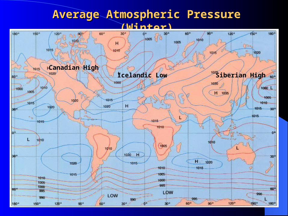
Average Atmospheric Pressure (Winter)Average Atmospheric Pressure (Winter)
Canadian HighIcelandic Low Siberian High

Global Belts of Low & High PressuresGlobal Belts of Low & High Pressures
In summer, the subtropical high pressure belt is not continuous in N.H., hence:
- over colder oceans, the Hawaiian and Bermuda high pressure persist
- But, over warmer land surface, Asian low pressure develops in this belt of high pressure

Global Belts of Low and High PressuresGlobal Belts of Low and High Pressures

Average Atmospheric Pressure (Summer)Average Atmospheric Pressure (Summer)
Bermuda HighAsian Low
Hawaiian High

The Nature of Atmospheric The Nature of Atmospheric PressurePressure
Mapping pressure with isobars– Pressure measured with
a barometer– Typical units are
millibars or inches of mercury
– Contour pressure values reduced to sea level
– Shows highs and lows, ridges and troughs

Nature of WindsNature of WindsSome Definitions:
Wind: Air in horizontal motionUpdraft: Small-scale air in upward
vertical motion Ascent: Large-scale air in upward
vertical motion Downdraft: Small-scale air in downward vertical motion
Subsidence:Large-scale air in downward vertical motion

The Nature of WindThe Nature of Wind
Origination of wind– Uneven heating of
Earth’s surface creates temperature and pressure gradients
– Direction of wind results from pressure gradient
– Winds blow from high pressure to low pressure
25

The Nature of WindThe Nature of Wind
Wind speed– Tight pressure gradients
(isobars close together) indicate faster wind speeds
– Wind speeds are gentle on average
26

Vertical Variations in Pressure Vertical Variations in Pressure and Windand Wind
Atmospheric pressure decreases rapidly with height
Atmospheric surface pressure centers lean with height
Winds aloft are much faster than at the surface
Jet streams
27

Causes of WindCauses of Wind
The principal causes of wind are:
- solar energy- pressure gradient force- coriolis force- frictional force

Causes of WindCauses of Wind
Solar Energy:
- differences in the distribution of solar energy determines low and high pressure belts
- air moves from high to low pressure areas

Causes of WindCauses of WindPressure Gradient Force:
- spatial variation of pressure produce pressure gradient force - the force causes air to move from high
to low pressure area across the isobars - determines wind direction and causes
wind to blow at right angle or perpendicular to the isobars

Pressure Gradient ForcePressure Gradient Force

Pressure Gradient Force OnlyPressure Gradient Force Only

Isobars: Pressure GradientIsobars: Pressure Gradient

Causes of WindCauses of Wind
- determines wind speed such that steeper pressure gradient force
produces stronger wind speed

Causes of WindCauses of Wind
Coriolis Force:- produced by earth rotation
- it turns wind to the right of its direction in the N.H. and to the left in the S.H.
- Coriolis effect increases in strength poleward
- It only affects wind direction, not wind speed, though faster winds turn more

Coriolis EffectCoriolis Effect

Geostrophic WindGeostrophic Wind

Coriolis Effect and Geostrophic WindsCoriolis Effect and Geostrophic Winds

Causes of WindCauses of Wind
- prevents the wind from flowing down the pressure gradient
- when pressure gradient force is equal to coriolis force, GEOSTROPHIC
WIND develop and moves parallel to the isobars

Causes of WindCauses of Wind
Frictional Resistance:- caused by surface roughness or molecular friction within the air stream - reduces wind speed by 60% on land and produces wind turbulence (eddying and
swirling motions)
- Does not affect upper levels

Frictional ResistanceFrictional Resistance

Causes of WindCauses of Wind
- wind speed is faster over water bodies because of smoother surface (only 40% reduction in speed)
- interferes with coriolis force by causing a less than 90o deflection
- produces 10 - 35o change in wind direction

Causes of WindCauses of Wind
results in wind blowing at some intermediate angle between pressure gradient and coriolis forces

The Influence of Pressure Gradient Force (PGF), The Influence of Pressure Gradient Force (PGF), Coriolis Effect (CE), and Frictional Resistance (FR) Coriolis Effect (CE), and Frictional Resistance (FR)
on Wind Directionon Wind Direction
950mb
1000mb
1050mb
CE
900mb

Effects of Friction, Coriolis Effect, and Effects of Friction, Coriolis Effect, and Pressure Gradient Force on Wind DirectionPressure Gradient Force on Wind Direction

CyclonesCyclones
Cyclones describe wind flow pattern around a low pressure center
air converge at the low pressure center and rises to the upper level
clouds can easily form
in the N.H., airflow is a counterclockwise in-spiral into the low pressure center

CyclonesCyclones
N.H. Cyclone (surface)Counterclockwise Flow
S.H. Cyclone (surface)Clockwise Flow

CyclonesCyclones
Converging & Rising Air in a Cyclone
Descending & Diverging Air in a Anticyclone

CyclonesCyclones
in the Southern Hemisphere, airflow is a clockwise in-spiral into the low pressure center
commonly associated with bad weather

AnticyclonesAnticyclones
air flow pattern around a high pressure center
air divergence at the high pressure center leading to air subsidence from the upper level
Northern Hemisphere: air flow is a clockwise out-spiral from the high pressure center

AnticyclonesAnticyclones
N.H. Anticyclone (surface)Clockwise Flow
S.H. Anticyclone (surface)Counterclockwise Flow

CyclonesCyclones
Converging & Rising Air in a Cyclone
Descending & Diverging Air in a Anticyclone

AnticyclonesAnticyclones
Southern Hemisphere: air flow is counterclockwise
Commonly associated with fine weather condition
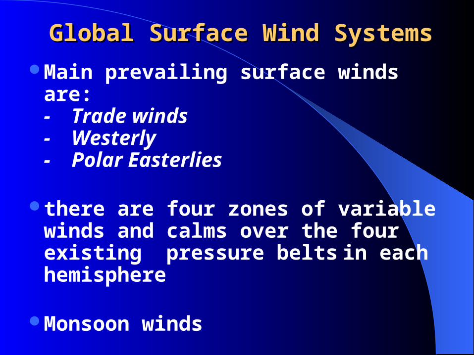
Global Surface Wind SystemsGlobal Surface Wind Systems Main prevailing surface winds are:
- Trade winds- Westerly- Polar Easterlies
there are four zones of variable winds and calms over the four existing pressure belts in each hemisphere
Monsoon winds

Global Surface Wind SystemsGlobal Surface Wind Systems

Global Surface Wind SystemsGlobal Surface Wind Systems

Global Surface Wind SystemsGlobal Surface Wind SystemsTrade Winds
- originates from the equator ward side of the subtropical high pressure belt
- the wind is deflected to the west in its movement to the equator to blow as an easterly wind
- in N.H., it is the North-East (NE) Trade wind

High Pressure Belt as Source of Surface WindsHigh Pressure Belt as Source of Surface Winds
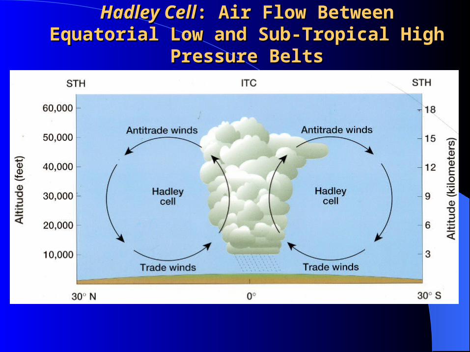
Hadley CellHadley Cell: Air Flow Between Equatorial Low : Air Flow Between Equatorial Low and Sub-Tropical High Pressure Beltsand Sub-Tropical High Pressure Belts

Trade Winds BeltTrade Winds Belt

Global Surface Wind SystemsGlobal Surface Wind Systems
- in S.H., it’s South-East Trade wind
- trade winds are persistent with a steady direction
- originates as warm dry winds and prevails between the equator & lat. 30º - could cause heavy precipitation over tropical oceans

High Pressure Belt as Source of Surface WindsHigh Pressure Belt as Source of Surface Winds

Global Surface Wind SystemsGlobal Surface Wind Systems
- The trade winds become monsoon wind in SE Asia and Africa once
they cross the equator
- Could cause dry and dusty winds when it blows over continents,
especially over desert areas
- Causes Harmattan wind in West Africa in December through March

Global Surface Wind SystemsGlobal Surface Wind Systems
Westerlies- originates on the poleward side of the
Subtropical High Pressure Belt
- wind prevails between lat. 30º and 60º
- disrupted by landmasses in N.H.
- they are strong and persistent winds in Southern Hemisphere

High Pressure Belt as Source of Surface WindsHigh Pressure Belt as Source of Surface Winds

The Westerlies BeltThe Westerlies Belt

Global Surface Wind SystemsGlobal Surface Wind Systems
- wind velocities increase poleward in the south and sailors describe these increases by terms like:
roaring fortiesfurious fiftiesscreaming sixties
- mid-latitude depressions are associated with this wind

Global Surface Wind SystemsGlobal Surface Wind Systems
Polar Easterlies- Global Surface Wind Systems- wind moves from east to west - it is cold and dry

Polar Easterlies BeltPolar Easterlies Belt

Global Surface Wind SystemsGlobal Surface Wind Systems
Intertropical Convergence Zone (ITCZ)- it is where the 2trade winds meet at or close to the equator
- zone of calm and variable winds (Doldrums)
- zone of weak horizontal airflow
Global Surface Wind SystemsGlobal Surface Wind Systems
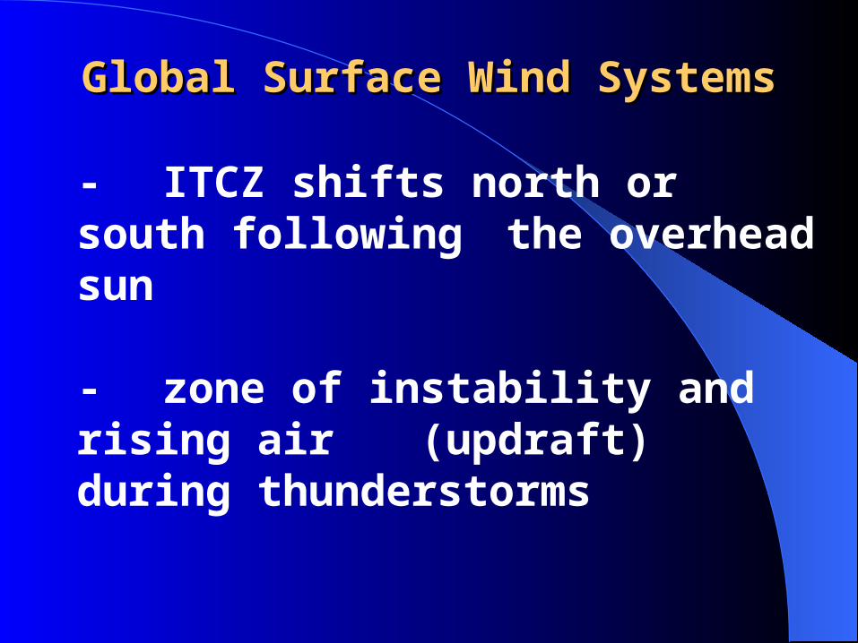
- ITCZ shifts north or south following the overhead sun - zone of instability and rising air (updraft) during thunderstorms

Local Wind SystemsLocal Wind Systems
The main types of local winds described are:
- Land and Sea Breeze- Chinook/Foehn Winds- Drainage Winds or Katabatic Winds- Mountain and Valley Winds

Local Wind Systems: Local Wind Systems: Land & Sea BreezeLand & Sea Breeze
Land and Sea Breeze- commonly experienced along tropical coastlines any time of the year and in summers in mid-latitudes
- involves sea breeze on land during the day and land breeze over the ocean
surface at night

Local Wind Systems: Local Wind Systems: Land & Sea BreezeLand & Sea Breeze
- caused by differential heating of land and water to form a small-scale
convectional circulation
- low pressure develops over warm land in the day causing low pressure to develop over land
- high pressure develops over relatively colder ocean surface during the day

Land and Sea BreezeLand and Sea Breeze

Local Wind Systems: Local Wind Systems: Land & Sea BreezeLand & Sea Breeze
- hence, sea breeze develops and blows - at night, low pressure develops over relatively warmer ocean surfaces and high pressure over relatively colder land surface
- hence land breeze develops & blows offshore over the oceans at night

Local Wind Systems: Local Wind Systems: Chinook/Foehn WindsChinook/Foehn Winds
It is a local downslope wind
It’s called Chinook (snow-eater) in the Rockies and foehn wind in the Alps
It begins as moisture laden wind that is forced to rise the windward side of the slope

Local Wind Systems: Local Wind Systems: Chinook/Foehn WindsChinook/Foehn Winds
It causes heavy precipitation on the wind ward side & a relatively dry wind is pulled over the leeward side of the mountain
the descending air is compressed and warmed up adiabatically
the wind arrives the base of the mountain on the leeward side as a warming, drying wind
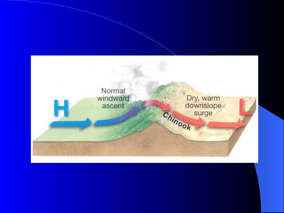

Chinook WindChinook Wind

Local Wind Systems: Local Wind Systems: Chinook/Foehn WindsChinook/Foehn Winds
It’s capable of melting snow very rapidly and makes it possible to keep the animals longer in the field in winter
A similar wind is called Santa Anas in California
Santa Anas is noted for its high speed, high temperature and extreme dryness

Local Wind Systems: Local Wind Systems: Chinook/Foehn WindsChinook/Foehn Winds
Santa Anas provides ideal condition for wildfires in summers and fall in California to spread rapidly
Chinook wind causes extreme dryness or the rain shadow effect on the leeward side

Chinook Wind and Rainshadow EffectChinook Wind and Rainshadow Effect

Local Wind Systems: Local Wind Systems: Drainage or Katabatic WindDrainage or Katabatic Wind
Common in cold uplands, high plateaus or high interior valleys of high latitudes, examples: Greenland and Antarctica
it involves the spill over of cold & dense air across low mountain divides (or through passes) downslope to lowland regions under the force of gravity

Local Wind Systems: Local Wind Systems: Drainage or Katabatic WindDrainage or Katabatic Wind
Hence, it is called Gravity-Flow Winds
It is called the Mistral wind along the Rhone Valley in southern France
Mistral wind originates in the Alps and channeled through the Rhone valley at high velocity to the Mediterranean Sea

Local Wind Systems: Local Wind Systems: Drainage or Katabatic WindDrainage or Katabatic Wind
It is also called Taku winds in southeastern Alaska

Local Wind Systems: Local Wind Systems: Mountain and Valley WindsMountain and Valley Winds
It’s a daily cycle of airflow between the valley side slopes and the valley bottoms
Valley side slopes are heated more rapidly during the day than the valley bottom
Hence, low pressure develops on the valley side slopes and high pressure at the valley bottom receiving less heat during the day

Mountain and Valley BreezeMountain and Valley Breeze

Local Wind Systems: Local Wind Systems: Mountain and Valley WindsMountain and Valley Winds
Hence, valley breeze invades the slope at daylight when pressure is low
Valley breeze are prominent during summer
An opposite process, the mountain breeze, operates at night

Local Wind Systems: Local Wind Systems: Mountain and Valley WindsMountain and Valley Winds
Valley side slopes lose heat very rapidly and become chilled at night
Hence, high pressure develops on the slopes & causing chilled and dense mountain side air to slip downslope as mountain breeze at night
Mountain breeze is more prominent in winter

Regional Wind Systems:Regional Wind Systems:Monsoonal Wind SystemsMonsoonal Wind Systems
Monsoon winds are seasonal wind shift of up to 180o
Monsoonal winds blow onshore in summer
Monsoonal winds blow offshore in winter
Well developed in the trade wind belts due to shifts in positions of ITCZ an unequal heating of land and water
Monsoonal Wind SystemsMonsoonal Wind Systems
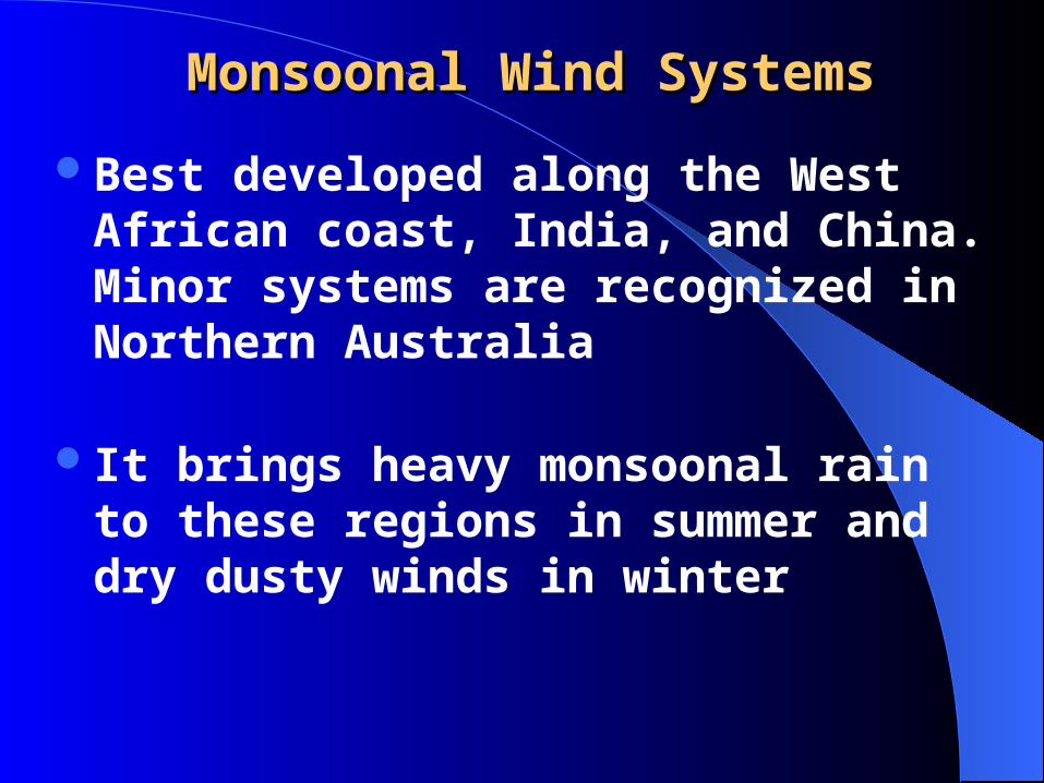
Best developed along the West African coast, India, and China. Minor systems are recognized in Northern Australia
It brings heavy monsoonal rain to these regions in summer and dry dusty winds in winter

Monsoonal System in AfricaMonsoonal System in Africa

Minor Monsoonal System

Monsoonal System in IndiaMonsoonal System in India

Monsoonal System in ChinaMonsoonal System in China

El Nino and La NinaEl Nino and La Nina
Warming of waters in the eastern equatorial Pacific
Associated with changes in weather patterns worldwide
Typically occurs on time scales of 3 to 7 years for about 18 months

El Nino and La NinaEl Nino and La NinaIn normal years, the coasts of Ecuador and
Peru are washed by cold Peruvian current
But in some years when the Equatorial currents are weak, warm ocean currents flow southward to replace the cold Peruvian current
This happens close to the end of the year and the natives named it El Nino (the child) after the child Jesus because of the Christmas season

El Nino: Walker Circulation PatternsEl Nino: Walker Circulation Patterns


El Nino and La NinaEl Nino and La NinaLocally, El Nino causes:
- abnormal weather patterns with abnormally high amount of rain inland
- hence, abnormal high crop yields and devastating floods in Ecuador and Peru observed
- but the fishing industry is usually devastated because the warm waters blocks the upwelling of nutrient rich cold waters

El Nino and La NinaEl Nino and La NinaThe effects of El Nino are felt across the globe:
- Causes severe drought in Australia, Indonesia, the Philippines and Africa Sahel
- 1997-98 El Nino brought severe storms accompanied by unusual beach erosion, landslide and floods to California
- Heavy rains and flood in Texas and the Gulf states and less hurricane events

El Nino and La NinaEl Nino and La NinaThe effects of El Nino are felt across the globe:
- Suppression of Atlantic hurricanes
- allows a pool of warm water over the Pacific to develop which in turn displaces the paths of both the polar and subtropical jet
streams
- hence, subtropical jet brought heavy winter precipitation to the Gulf coast and the polar jet brought milder winter far north

El Nino and La NinaEl Nino and La NinaThe effects of El Nino are felt across the globe:
- or warmer than normal winter in northern United States and Canada persists

El Nino and La NinaEl Nino and La NinaDuring an El Nino year, high pressure develops
in the western pacific near Australia and low pressure in east pacific
When El Nino comes to an end, the pressure situation reverses such that east pacific has high pressure and the west low pressure
This phenomenon is referred to as El Nino Southern Oscillation (ENSO)


El Nino and La NinaEl Nino and La NinaWhat was once regarded as the normal
condition with high pressure and cold current in eastern pacific is now referred to as La Nina
Researchers restrict La Nina to periods when surface temperatures are colder than average


El Nino and La NinaEl Nino and La NinaLa Nina has its distinct weather patterns:
- colder than normal winter of the Pacific Northwest and Northern Great Plains
- Warming experienced in the rest of the United States
- Great hurricane activity producing more than 20 times more damage than El Nino years

Review Questions for Topic 5Review Questions for Topic 5

1)1) The force exerted by gas molecules on some area of The force exerted by gas molecules on some area of Earth’s surface or any other body is called what?Earth’s surface or any other body is called what?
A. Density
B. Wind
C. Atmospheric pressure
D. Friction
E. Geotropism
Figure 5-1

1)1) The force exerted by gas molecules on some area of The force exerted by gas molecules on some area of Earth’s surface or any other body is called what?Earth’s surface or any other body is called what?
A. Density
B. Wind
C. Atmospheric pressure
D. Friction
E. Geotropism
Explanation: Gas molecules, when in contact with a surface, will exert a force on that surface. This force corresponds to atmospheric pressure.
Figure 5-1

2) 2) Lines drawn on maps joining areas of equal Lines drawn on maps joining areas of equal atmospheric pressure are called what?atmospheric pressure are called what?
A. Wavelengths
B. Isotherms
C. Contours lines
D. Isohyets
E. Isobars
Figure 5-4

2) 2) Lines drawn on maps joining areas of equal Lines drawn on maps joining areas of equal atmospheric pressure are called what?atmospheric pressure are called what?
A. Wavelengths
B. Isotherms
C. Contours lines
D. Isohyets
E. Isobars
Explanation: Lines of constant pressure, by definition, are called isobars.
Figure 5-4

3) 3) Due to Coriolis force, freely moving objects in the Due to Coriolis force, freely moving objects in the Northern Hemisphere appear to be deflected toNorthern Hemisphere appear to be deflected to
A. the left.
B. the right.
C. the ocean.
D. the east.
E. the west.

3) 3) Due to Coriolis force, freely moving objects in the Due to Coriolis force, freely moving objects in the Northern Hemisphere appear to be deflected toNorthern Hemisphere appear to be deflected to
A. the left.
B. the right.
C. the ocean.
D. the east.
E. the west.
Explanation: In the Northern Hemisphere, winds are deflected to the right by Coriolis. In the Southern Hemisphere, winds are deflected to the left
Figure 5-6

4) 4) The air that descends and spirals out of the subtropical The air that descends and spirals out of the subtropical high pressure belt is the source of high pressure belt is the source of
A. polar easterlies.
B. trade winds and the westerlies.
C. Chinooks.
D. land and sea breeze.
E. the monsoons.
Explanation: As seen in Figure 5-14, the subtropical high is the source location for both the mid-latitude westerlies and the trade winds.
Figure 5-14

5) 5) A sea breeze is experienced A sea breeze is experienced
A. in the night.
B. in winter.
C. during the day.
D. at dawn only.
E. when air over land is too heavy to be lifted by convective currents.

5) 5) A sea breeze is experienced A sea breeze is experienced
A. in the night.
B. in winter.
C. during the day.
D. at dawn only.
E. when air over land is too heavy to be lifted by convective currents.
Explanation: During the day, the land heads faster than the water, creating athermal low on land and a thermal high over water. The winds will blow fromhigh to low pressure, creating a sea breeze.
Figure 5-34a

6) 6) The semi-permanent area of high pressure over the The semi-permanent area of high pressure over the poles of Earth is an example of poles of Earth is an example of
A. a subtropical high.
B. a sea breeze.
C. a dynamic high.
D. a thermal high.
E. a midlatitude anticyclone.
Figure 5-14

6) 6) The semi-permanent area of high pressure over the The semi-permanent area of high pressure over the poles of Earth is an example of poles of Earth is an example of
A. a subtropical high.
B. a sea breeze.
C. a dynamic high.
D. a thermal high.
E. a midlatitude anticyclone.
Explanation: The area of high pressure over the poles is an example of a thermal high.When the air gets extremely cold and dense over these regions, it becomes very heavy, thus exerting higher pressure on the surface as a result of its temperature.
Figure 5-14

7) 7) An El Niño is observed asAn El Niño is observed as
A. a cooling of equatorial Pacific waters.
B. high pressure over western South America.
C. a warming of eastern equatorial Pacific waters.
D. low pressure over Australia.
E. rainy conditions for Australia.
Figure 5-37

7) 7) An El Niño is observed asAn El Niño is observed as
A. a cooling of equatorial Pacific waters.
B. high pressure over western South America.
C. a warming of eastern equatorial Pacific waters.
D. low pressure over Australia.
E. rainy conditions for Australia.
Explanation: During an El Niño event, water over the eastern equatorial Pacific (off the west coast of South America) becomes abnormally warm, resulting in a switch of the Walker Circulation.
Figure 5-37

8) 8) Waves in the jet stream pattern are calledWaves in the jet stream pattern are called
A. Kelvin waves.
B. electromagnetic waves.
C. shallow water waves.
D. Coriolis waves.
E. Rossby waves. Figure 5-24
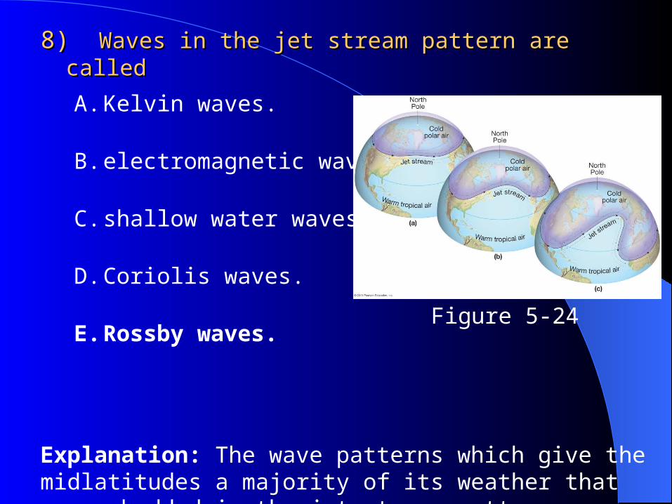
8) 8) Waves in the jet stream pattern are calledWaves in the jet stream pattern are called
A. Kelvin waves.
B. electromagnetic waves.
C. shallow water waves.
D. Coriolis waves.
E. Rossby waves.
Explanation: The wave patterns which give the midlatitudes a majority of its weather that are embedded in the jet stream pattern are called Rossby waves.
Figure 5-24

9) 9) Which type of wind is an example of a katabatic wind?Which type of wind is an example of a katabatic wind?
A. Foehn
B. Gale
C. Bora
D. Chinook
E. Santa Ana

9) 9) Which type of wind is an example of a katabatic wind?Which type of wind is an example of a katabatic wind?
A. Foehn
B. Gale
C. Bora
D. Chinook
E. Santa Ana
Explanation: A bora wind is a strong cold wind that affects the lee slopes of a mountain range. It is katabatic because it is a cold wind.

10) 10) Air which has decreased in density and temperature willAir which has decreased in density and temperature will
A. be warmer.
B. have a higher air pressure.
C. have a lower air pressure.
D. sink.
E. compress.
Figure 5-3

10) 10) Air which has decreased in density and temperature willAir which has decreased in density and temperature will
Explanation: Air temperature and density are directly related to pressure. If air temperature and density decrease, the pressure must also decrease as a result of the temperature and density decrease.
A. be warmer.
B. have a higher air pressure.
C. have a lower air pressure.
D. sink.
E. compress.
Figure 5-3

The General Circulation of the The General Circulation of the AtmosphereAtmosphere
131
Atmosphere is in constant motion Major semipermanent conditions of wind and
pressure—general circulation Principal mechanism for longitudinal and latitudinal
heat transfer Second only to insolation as a determination for
global climate
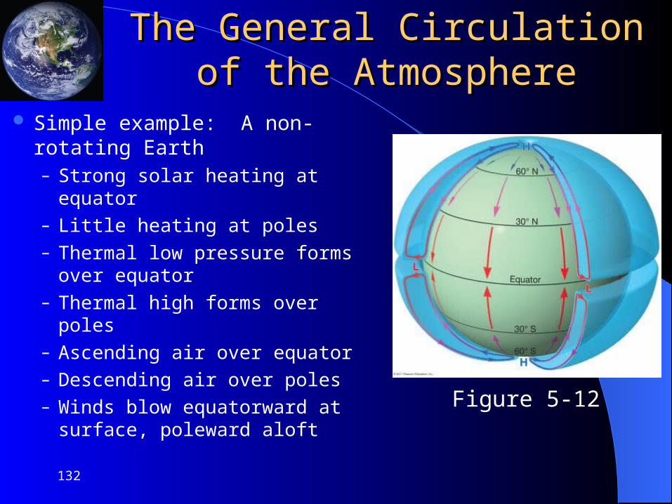
The General Circulation of the The General Circulation of the AtmosphereAtmosphere
Simple example: A non-rotating Earth– Strong solar heating at equator– Little heating at poles– Thermal low pressure forms over
equator– Thermal high forms over poles– Ascending air over equator– Descending air over poles– Winds blow equatorward at
surface, poleward aloft
132
Figure 5-12

The General Circulation of the The General Circulation of the AtmosphereAtmosphere
Observed general circulation– Addition of Earth’s rotation
increases complexity of circulation
– One semipermanent convective cell near the equator
– Three latitudinal wind belts per hemisphere
– Hadley cells
133
Figure 5-14

The General Circulation of the The General Circulation of the AtmosphereAtmosphere
Seasonal differences in the general circulation
134
Figure 5-15

The General Circulation of the The General Circulation of the AtmosphereAtmosphere
Components of the general circulation– Subtropical highs
Persistent zones of high pressure near 30° latitude in both hemispheres
Result from descending air in Hadley cells
Subsidence is common over these regions
Regions of world’s major deserts
No wind, horse latitudes
135
Figure 5-16
The General Circulation of the The General Circulation of the AtmosphereAtmosphere
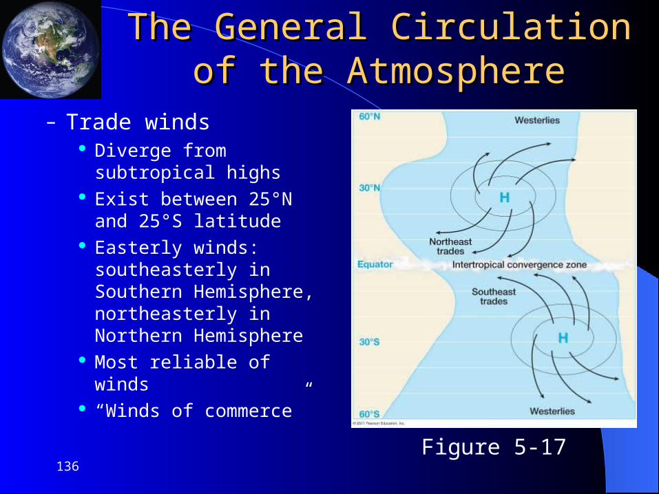
– Trade winds Diverge from subtropical
highs Exist between 25°N and 25°S
latitude Easterly winds: southeasterly
in Southern Hemisphere, northeasterly in Northern Hemisphere
Most reliable of winds “Winds of commerce”
136Figure 5-17

The General Circulation of the The General Circulation of the AtmosphereAtmosphere
– Trade winds (cont.) Heavily laden with
moisture Do not produce rain
unless forced to rise If they rise, they produce
tremendous precipitation and storm conditions
137
Figure 5-20

The General Circulation of the The General Circulation of the AtmosphereAtmosphere
– Intertropical Convergence Zone (ITCZ)
Region of convergence of the trade winds
Constant rising motion and storminess in this region
Position seasonally shifts (more over land than water)
Doldrums
138
Figure 5-21

The General Circulation of the The General Circulation of the AtmosphereAtmosphere
– Westerlies Form on poleward sides of
subtropical highs Wind system of the
midlatitudes Two cores of high winds –
jet streams Rossby waves
139
Figure 5-22
Figure 5-24

The General Circulation of the The General Circulation of the AtmosphereAtmosphere
– Polar highs Thermal highs that develop over poles due to extensive
cold conditions Winds are anticyclonic; strong subsidence Arctic desert
– Polar easterlies Regions north of 60°N and south of 60°S Winds blow easterly Cold and dry
140

The General Circulation of the The General Circulation of the AtmosphereAtmosphere
– Polar front Low pressure area between
polar high and westerlies Air mass conflict between
warm westerlies and cold polar easterlies
Rising motion and precipitation
Polar jet stream position typically coincident with the polar front
141
Figure 5-25

The General Circulation of the The General Circulation of the AtmosphereAtmosphere
The seven components of the general circulation
142Figure 5-26

The General Circulation of the The General Circulation of the AtmosphereAtmosphere
Vertical wind patterns of the general circulation– Most dramatic
differences in surface and aloft winds is in tropics
– Antitrade winds
143
Figure 5-28

Modifications of the General Modifications of the General CirculationCirculation
Seasonal modifications– Seven general circulation
components shift seasonally
– Components shift northward during Northern Hemisphere summer
– Components shift southward during Southern Hemisphere summer
144
Figure 5-29

Modifications of the General Modifications of the General CirculationCirculation
Monsoons– Seasonal wind shift of up to
180°– Winds onshore during summer– Winds offshore during winter– Develop due to shifts in
positions of ITCZ and unequal heating of land and water
145
Figure 5-30

Modifications of the General Modifications of the General CirculationCirculation
Major monsoon systems
146
Figure 5-32

Modifications of the General Modifications of the General CirculationCirculation
Minor monsoon systems
147
Figure 5-33

Localized Wind SystemsLocalized Wind Systems
Sea breezes– Water heats more slowly than
land during the day– Thermal low over land, thermal
high over sea– Wind blows from sea to land
Land breezes– At night, land cools faster– Thermal high over land,
thermal low over sea– Wind blows from land to sea
148
Figure 5-34

Localized Wind SystemsLocalized Wind Systems
Valley breeze– Mountain top during the day heats
faster than valley, creating a thermal low at mountain top
– Upslope winds out of valley Mountain breeze
– Mountain top cools faster at night, creating thermal high at mountain top
– Winds blow from mountain to valley, downslope
149
Figure 5-35

Localized Wind SystemsLocalized Wind Systems
Katabatic winds– Cold winds that originate from
cold upland areas, bora winds– Winds descend quickly down
mountain, can be destructive Foehn/Chinook winds
– High pressure on windward side of mountain, low pressure on leeward side
– Warm downslope winds– Santa Ana winds
150
Figure 5-36