Embed Size (px)
Citation preview

ATM Research in Japan
13 June 2013
Yutaka Fukuda
Japan Civil Aviation Bureau (JCAB)
CARATS R&D Sub-Committee
Air Traffic Management Department Electronic Navigation Research Institute
10th USA/Europe ATM R&D Seminar
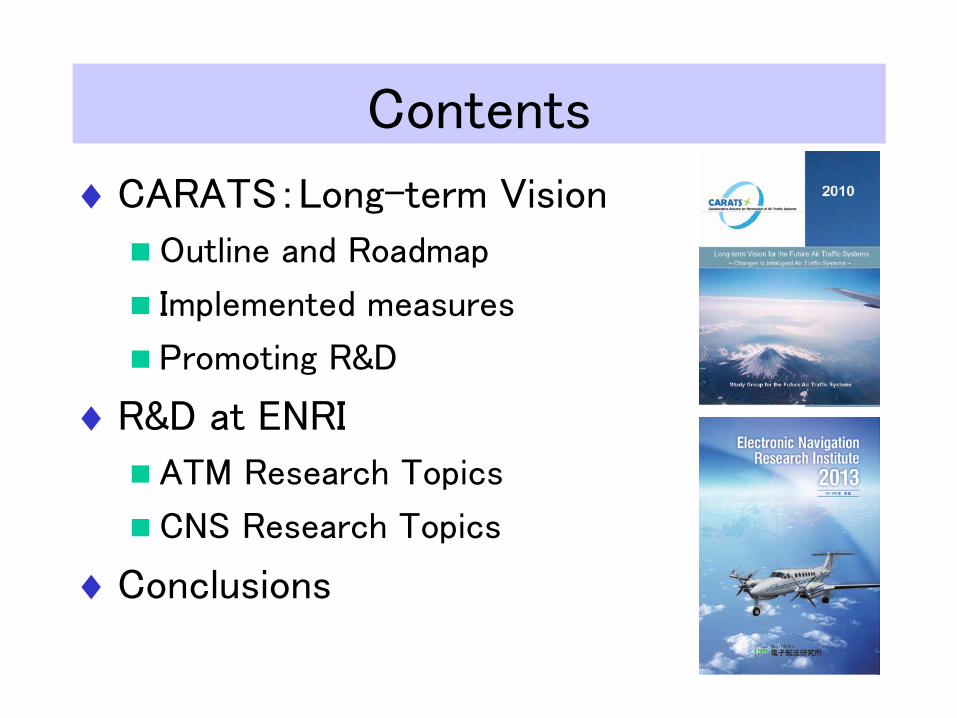
Contents
♦CARATS:Long-term Vision
Outline and Roadmap
Implemented measures
Promoting R&D
♦R&D at ENRI
ATM Research Topics
CNS Research Topics
♦Conclusions
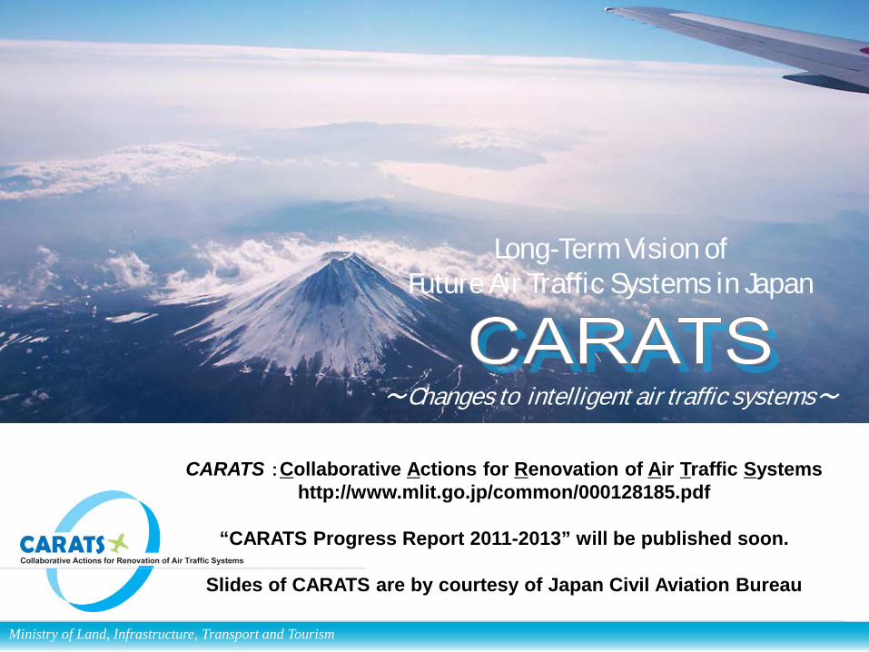
Long-Term Vision of Future Air Traffic Systems in Japan
~Changes to intelligent air traffic systems~
Ministry of Land, Infrastructure, Transport and Tourism
CARATS :Collaborative Actions for Renovation of Air Traffic Systems http://www.mlit.go.jp/common/000128185.pdf
“CARATS Progress Report 2011-2013” will be published soon.
Slides of CARATS are by courtesy of Japan Civil Aviation Bureau
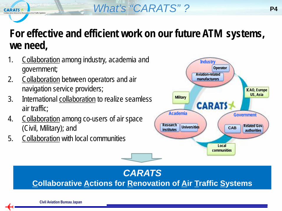
CARATS Collaborative Actions for Renovation of Air Traffic Systems
Related Gov. authorities
ICAO, Europe US, Asia
Government
Research institutes CAB
Industry Operator
Military
Local communities
Universities
Aviation-related manufacturers
Academia
For effective and efficient work on our future ATM systems, we need, 1. Collaboration among industry, academia and
government; 2. Collaboration between operators and air
navigation service providers; 3. International collaboration to realize seamless
air traffic; 4. Collaboration among co-users of air space
(Civil, Military); and 5. Collaboration with local communities
What’s “CARATS” ? P4
Ministry of Land, Infrastructure, Transport and Tourism Civil Aviation Bureau Japan
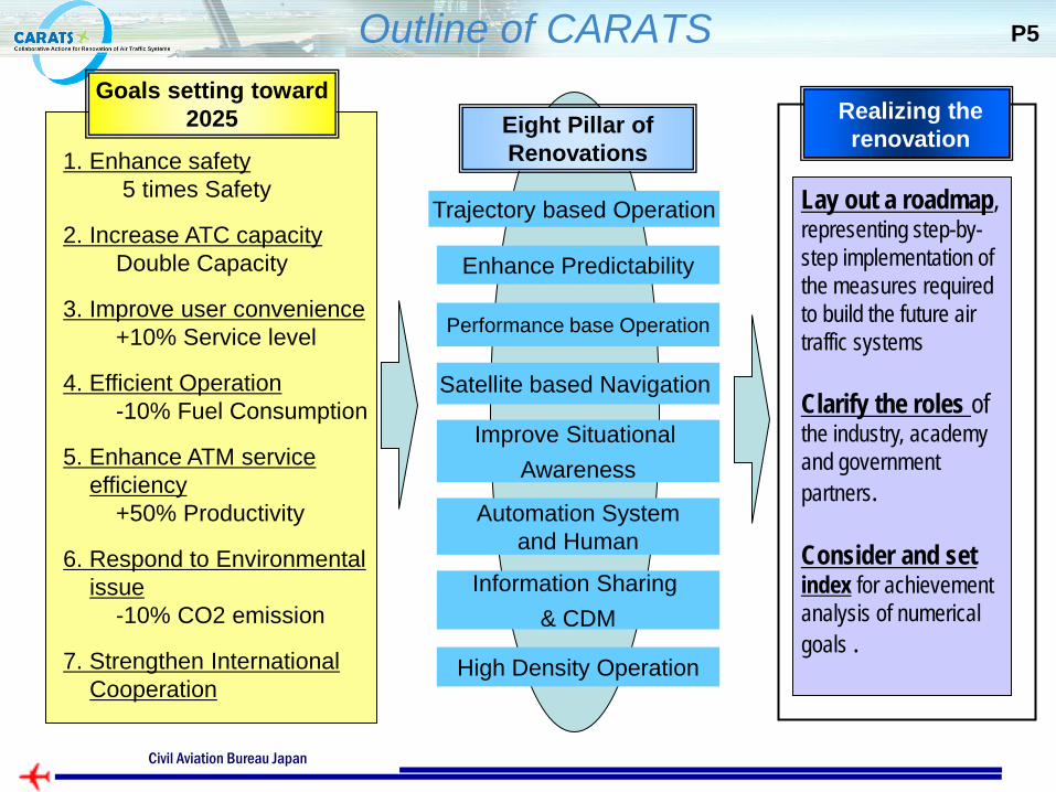
Outline of CARATS Goals setting toward
2025
1. Enhance safety 5 times Safety
2. Increase ATC capacity Double Capacity
3. Improve user convenience +10% Service level
4. Efficient Operation -10% Fuel Consumption
5. Enhance ATM service efficiency +50% Productivity
6. Respond to Environmental issue -10% CO2 emission
7. Strengthen International Cooperation
Eight Pillar of Renovations
Trajectory based Operation
Enhance Predictability
Satellite based Navigation
Improve Situational Awareness
Automation System and Human
Information Sharing & CDM
Realizing the renovation
Lay out a roadmap, representing step-by-step implementation of the measures required to build the future air traffic systems Clarify the roles of the industry, academy and government partners. Consider and set index for achievement analysis of numerical goals .
Performance base Operation
High Density Operation
P5
Ministry of Land, Infrastructure, Transport and Tourism Civil Aviation Bureau Japan
Civil Aviation Bureau Japan
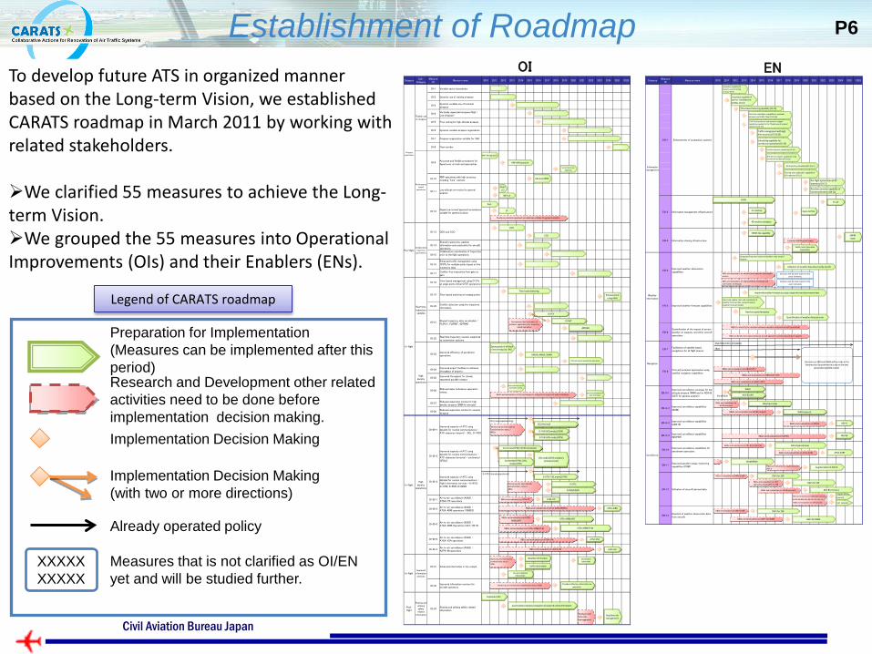
OI
XXXXX XXXXX
Already operated policy
Measures that is not clarified as OI/EN yet and will be studied further.
Implementation Decision Making (with two or more directions)
Implementation Decision Making
Research and Development other related activities need to be done before implementation decision making.
Preparation for Implementation (Measures can be implemented after this period)
EN
Legend of CARATS roadmap
Establishment of Roadmap Category
Sub-Category
MeasureID
Measure name 2010 2011 2012 2013 2014 2015 2016 2017 2018 2019 2020 2021 2022 2023 2024 2025 >2025
OI-1 Variable sector boundaries
OI-2 Dynamic use of training airspace
OI-3Dynamic variable use of terminalairspace
OI-4Vertically seperated airspace (High /Low airspace)
OI-5 Free routing for high altitude airspace
OI-6 Dynamic variable airspace organization
OI-7 Airspace organization suitable for TBO
OI-8 Flow corridor
OI-9Accurate and flexible procedures fordepartures, arrivals and approaches
OI-10RNP operations with high accuracyincluding "time" element
OI-11Low altitude en-routes for generalaviation
OI-12Departure/arrival/approach proceduressuitable for general aviation
OI-13 CDO and CCO
OI-14Shared trajectories, weatherinformation and constraints for aircraftoperations
OI-15Collaborative coordination of trajectriesprior to the flight operations
OI-16Enhanced traffic management usingCFDTs for multiple points based on thetrajectory data
OI-17Conflict-free trajectries from gate togate
OI-18Time-based management using CFDTsat single points (Intial CFDT operations)
OI-19 Time-based metering at merging points
OI-20Conflict detection using the trajectoryinformation
OI-21Shared trajectory data via datalink /FLIPCY、FLIPINT、4DTRAD
OI-22Real time trajectory revision supportedby automation systems
OI-23Improved efficiency of aerodromeoperations
OI-24Improved airport facilities to enhancethroughput of airports
OI-25Improved throughput for closelyseparated parallel runways
OI-26Reduced wake turbulence separationminima
OI-27Reduced separation minima for highdensity airspace (3NM for enroute)
OI-28Reduced separation minima for oceanicairspace
OI-29-1Improved capacity of ATC usingdatalink for routine communications /ATC clearance (airport) - DCL, D-TAXI
OI-29-2
Improved capacity of ATC usingdatalink for routine communications /ATC clearance (enroute) - continentalCPDLC
OI-29-3
Improved capacity of ATC usingdatalink for routine communications /Flight information services - D-ATIS,D-OTIS, D-RVR, D-HZWX
OI-30-1Air-to-air surveillance (ASAS) /ATSA-ITP operations
OI-30-2Air-to-air surveillance (ASAS) /ATSA-AIRB operations (1090ES)
OI-30-3Air-to-air surveillance (ASAS) /ATSA-AIRB Operations (UAT/TIS-B)
OI-30-4Air-to-air surveillance (ASAS) /ATSA-VSA operations
OI-30-5Air-to-air surveillance (ASAS) /ASPA-IM opeartions
OI-31 Enhanced information in the cockpit
OI-32Improved information services foraircraft operators
Post-flight
Sharing andutilizingsafetyrelated
information
OI-33Sharing and utilizing safety relatedinformation
Airspace
organization
Flexible useof airspace
Performancebased
operations
Pre-flightCollaborative
trajectorygenerations
In-flightImproved
informationservices
In-flight
Real-timetrajectoryupdates
Highdensity
operations
In-flightHigh
densityoperations
CDO
Optimazation of off-block time (Introducing TSAT)
CCO
RNAV1/2
RNP 0.3
RNP AR Approach
RNP AR Departure
Advanced RNP
Curved precision Approach
PinS
LP
DMAN, AMAN, SMAN
Detection/prediction of wake turbulence
Reflected wind data to separation minima
accumulation/analysis/evaluation of acquired safety information
Real time risk management
Aeronautical information
Terrain / obstacle information
Provided effective information to operators
FLIPCY
FLPINT
4DTRAD
Enhancement using ASAS
Traffic information
Weather information
D-TAXI (VDL mode2/AOA)
D-TAXI (VDL mode2/ATN)
DCL (Revised)DCL (now implementing)
Continental CPDLC (FANS compliant)
Continental CPDLC (VDL mode2/ATN)
VDL mode2/ATN compliant (enhancement)
D-ATIS (VDL mode2/ATN)
D-OTIS
D-RVR/HZWX
D-ATIS (already operational)
ATSA-AIRB(TIS-B)
ATSA-AIRB(UAT)
ATSA-AIRB
ATSA-ITP
ATSA-VSA
ASPA-IM
Time-based metering
Efficient overall aerodrome operations
Development and evaluation of Software applications for Trajectory
based operations
Study on precision approach procedures suitable for general aviation
Monitoring the International standardization status /R&Ds
Monitoring the International standardization status /R&Ds
R&Ds and evaluations on ATSA-AIRB(TIS-B)
R&Ds and evaluations on ATSA-AIRB(UAT)
R&Ds and evaluations on ATSA-AIRB(1090ES)
R&Ds and evaluations on ATSA-ITP
R&Ds and evaluations on ATSA-VSA
R&Ds and evaluations on ASPA-IM
Monitoring the International standardization status /R&Ds
Monitoring the International standardization status / R&Ds
Study on real time risk management
Implement SSP
R&Ds and evaluations on the techniques to mitigate the impact of wake turbulence
CategoryMeasure
IDMeasure name 2010 2011 2012 2013 2014 2015 2016 2017 2018 2019 2020 2021 2022 2023 2024 2025 >2025
EN-2 Information management infrastructure
EN-3 Information sharing infrastructure
EN-4Improved weather observationcapabilities
EN-5 Improved weather forecast capabilities
EN-6Quantification of the impact of severeweather on capacity and other aircraftoperations
EN-7Facilitation of satellite basednavigations for all flight phases
EN-8(Curved) precision approaches usingsatellite navigation capabilities
EN-9-1Improved surveillance coverage for lowaltitude airspace (WAM and/or ADS-B(UAT) for general aviation)
EN-9-2Improved surveillance capabilities(WAM)
EN-9-3Improved surveillance capabilities(ADS-B)
EN-9-4Improved surveillance capabilities(MSPSR)
EN-10Improved surveillance capabilities foraerodrome operations
EN-11Improved parallel runway monitoringcapabilities (PRM)
EN-12 Utilization of aircraft derived data
EN-13Downlink of weather observation datafrom aircraft
Surveillance
Informationmanagement
EN-1 Enhancement of automation systems
Weatherinformation
Navigation
Fast time simulation capability to evaluate airspace and traffic flow (OI-1,3,6)
Evaluation capability of dynamic use of training airspace (OI-2)
Traffic flow prediction and operation support capabilities needed for the "flexible use of airspace" operations (OI-3,6)
Calculation capablily of optimal climb/descent profiles (OI-13)
4D trajectory calculation(OI-15,17)
Sharing and coodination capabiliy of 4D trajectory (OI-15)
Traffic management with high time accuracy (OI-16,18)
Time-based metering capability (OI-19)
Pre-flight optimization of 4D trajectory (OI-17)
Conflict detection capabilities (OI-20)
ATC decision support capabilities using aircraft derived data (OI-20,22)
Scheduling capability for aerodrome operations (OI-23)
Decisions on SBAS and GBAS will be made in the flamework of conprehensive study on the next
generation satellite system.
DME/DME/(IRU), GPS(ABAS)
SBAS
ADS-B
MSPSR
WAM (enroute)
WAM (airport)
WAM
ADS-B(UAT)low altitude
SWIM-like capability
FODBFF-ICE
4D weather database
Digital NOTAM
SWIM (Initial Operation Capabilities)
SWIM(SOA)
GIS database
Integrated/improved observed weather data around airports
Utilization of weather data observed by aircraft
Decisions will be made based on the users' demands.
Improved weather forecast accuracy using enhanced observation data
Improved update rates and resolutions of weather forecast data using enhanced weather forecast models
New forecast information
Quantification of weather forecast error
DAPs for SSR
DAPs for WAM
ADS-B (enroute)
1090ES ADS-B (airprot)
DAPs for SSR
DAPs for SSR
ADS-B (aerodrome)
ATSA-SURF
WAM(PRM)
Augmentation of ADS-B
R&Ds and evaluations on GBAS CAT-I
R&Ds and evaluations on GBAS (TAP)
R&Ds and evaluations on GBAS CAT-II/III
R&Ds and evaluations on WAM (enroute)
R&Ds and evaluations on WAM (airport)
R&Ds and evaluations on DAPs for SSR
R&Ds and evaluations on DAPs for WAM
Establish SWIM governance
R&Ds and evaluations on existent/new weather observation sensors
R&Ds and evaluations on improvements of volcanic ash observation techniques
R&Ds to identify the relation between weather data and aircraft operations
R&Ds to identify the relation between aircraft operations and airspace/airport capacity
R&Ds and evaluations on DAPs for SSR
R&Ds and evaluations on ADS-B (enroute)
R&Ds and evaluations on 1090ES ADS-B (airport)
R&Ds and evaluations on 4DT operations using DAPs for SSR
R&Ds and evaluations on ADS-B (aerodrome)
R&Ds and evaluations on ATSA-SURF
R&Ds and evaluations on augmentation of ADS-B
R&Ds and evaluations on ADS-B
R&Ds and evaluations on MSPSR
Real time provision capability of revised trajectories (OI-22)
Decisions will be made based on the users' demands.
R&Ds and evaluations on UAT (airport) UAT (airprot)
P6
To develop future ATS in organized manner based on the Long-term Vision, we established CARATS roadmap in March 2011 by working with related stakeholders. We clarified 55 measures to achieve the Long-term Vision. We grouped the 55 measures into Operational Improvements (OIs) and their Enablers (ENs).
Civil Aviation Bureau Japan
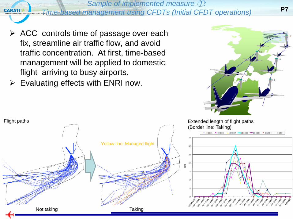
Sample of implemented measure ①: Time-based management using CFDTs (Initial CFDT operations) P7
Yellow line: Managed flight
Flight paths Extended length of flight paths (Border line: Taking)
Not taking Taking
ACC controls time of passage over each fix, streamline air traffic flow, and avoid traffic concentration. At first, time-based management will be applied to domestic flight arriving to busy airports.
Evaluating effects with ENRI now.
Ministry of Land, Infrastructure, Transport and Tourism
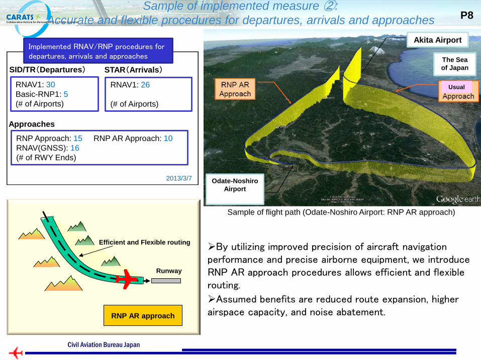
Sample of implemented measure ②: Accurate and flexible procedures for departures, arrivals and approaches P8
Sample of flight path (Odate-Noshiro Airport: RNP AR approach)
RNAV1: 30 Basic-RNP1: 5 (# of Airports)
RNP Approach: 15 RNP AR Approach: 10 RNAV(GNSS): 16 (# of RWY Ends)
RNAV1: 26 (# of Airports)
SID/TR(Departures) STAR(Arrivals)
Approaches
2013/3/7
Implemented RNAV/RNP procedures for departures, arrivals and approaches
Runway
Efficient and Flexible routing
RNP AR approach
By utilizing improved precision of aircraft navigation performance and precise airborne equipment, we introduce RNP AR approach procedures allows efficient and flexible routing.
Assumed benefits are reduced route expansion, higher airspace capacity, and noise abatement.
Akita Airport
Odate-Noshiro Airport
Usual
The Sea of Japan
Ministry of Land, Infrastructure, Transport and Tourism Civil Aviation Bureau Japan
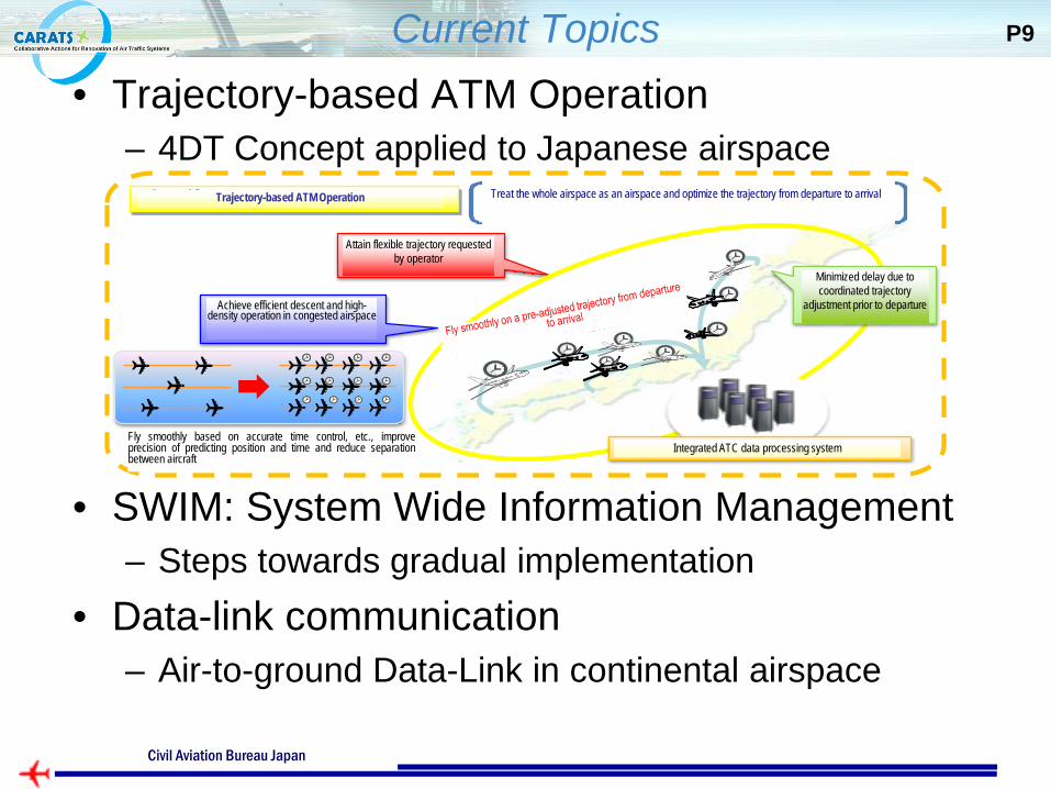
Current Topics • Trajectory-based ATM Operation
– 4DT Concept applied to Japanese airspace
• SWIM: System Wide Information Management – Steps towards gradual implementation
• Data-link communication – Air-to-ground Data-Link in continental airspace
P9
軌道ベースのATM運用
運航者の希望する自由度の高い飛行軌道を実現
運航前からの協調的な 軌道調整により、遅延の最小化
統合された管制情報処理システム
混雑空域において、効率的な降下方式や高密度運航を実現
(正確な時間管理等により、整然と飛行するとともに、位置、時間の予見精度を向上し、航空機間隔を短縮)
全体を1つの空域として捉え、出発から到着までの軌道を最適化
Trajectory-based ATM Operation Treat the whole airspace as an airspace and optimize the trajectory from departure to arrival
Fly smoothly based on accurate time control, etc., improve precision of predicting position and time and reduce separation between aircraft
Minimized delay due to coordinated trajectory
adjustment prior to departure
Attain flexible trajectory requested by operator
Achieve efficient descent and high-density operation in congested airspace
Integrated ATC data processing system
Ministry of Land, Infrastructure, Transport and Tourism Civil Aviation Bureau Japan
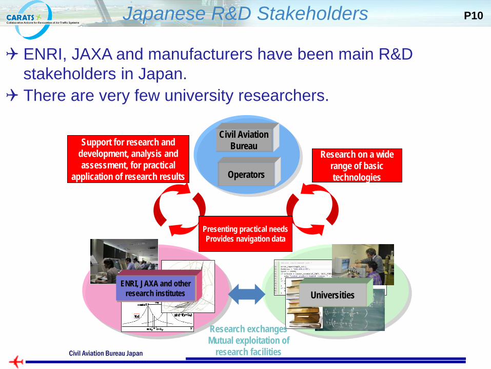
Japanese R&D Stakeholders P10
ENRI, JAXA and manufacturers have been main R&D stakeholders in Japan.
There are very few university researchers.
大学
研究交流・
研究施設の相互利用
研究機関
研究開発・分析・評価等
研究成果の実用化支援
実用上のニーズを提示
運航データの提供
航空局
運航者幅広い
基礎技術の研究
Civil Aviation Bureau Support for research and
development, analysis and assessment, for practical
application of research results
Universities
Research on a wide range of basic technologies Operators
Presenting practical needs Provides navigation data
ENRI, JAXA and other research institutes
Research exchanges Mutual exploitation of
research facilities Ministry of Land, Infrastructure, Transport and Tourism
Civil Aviation Bureau Japan
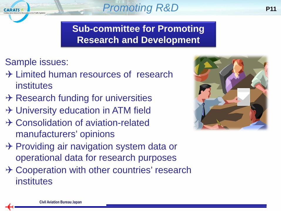
Promoting R&D P11
Sub-committee for Promoting Research and Development
Sample issues: Limited human resources of research
institutes Research funding for universities University education in ATM field Consolidation of aviation-related
manufacturers’ opinions Providing air navigation system data or
operational data for research purposes Cooperation with other countries’ research
institutes
Ministry of Land, Infrastructure, Transport and Tourism Civil Aviation Bureau Japan
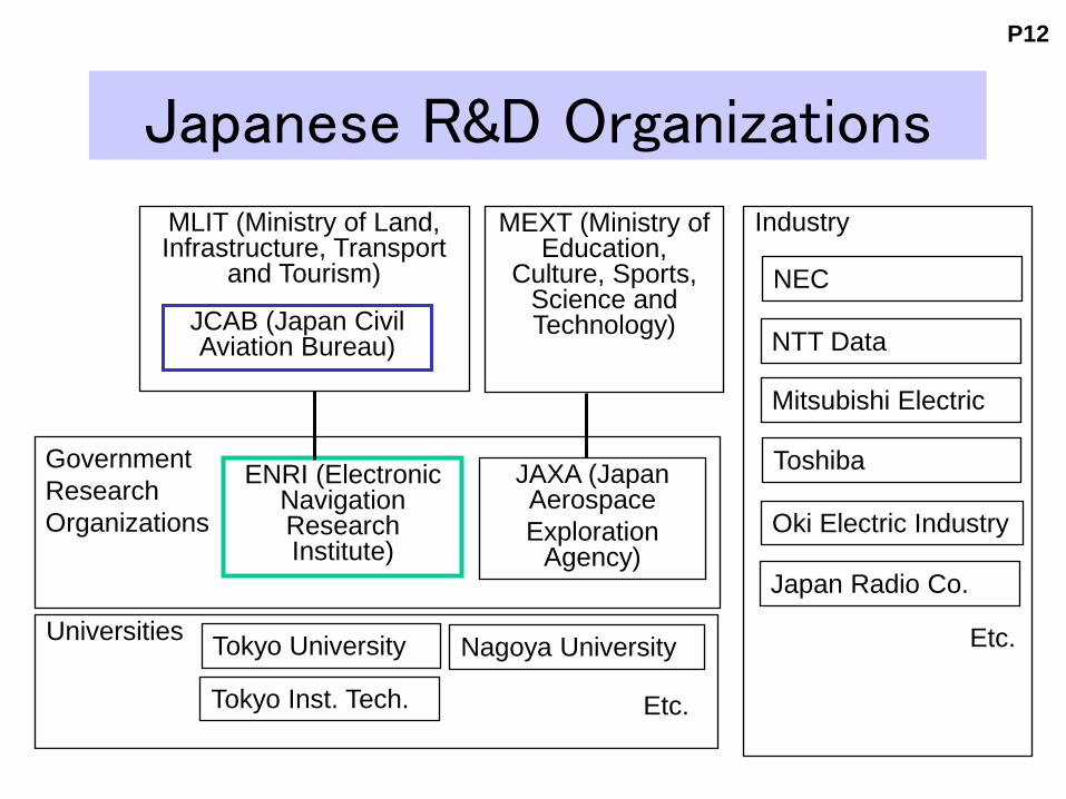
Japanese R&D Organizations
MEXT (Ministry of Education,
Culture, Sports, Science and Technology)
MLIT (Ministry of Land, Infrastructure, Transport
and Tourism)
JAXA (Japan Aerospace Exploration
Agency)
ENRI (Electronic Navigation Research Institute)
JCAB (Japan Civil Aviation Bureau)
Universities
Government Research Organizations
Tokyo University Nagoya University
Tokyo Inst. Tech. Etc.
P12
Industry
NEC
NTT Data
Toshiba
Mitsubishi Electric
Oki Electric Industry
Japan Radio Co.
Etc.
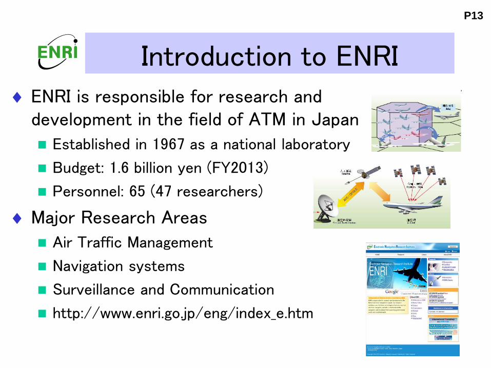
Introduction to ENRI ♦ ENRI is responsible for research and
development in the field of ATM in Japan
Established in 1967 as a national laboratory
Budget: 1.6 billion yen (FY2013)
Personnel: 65 (47 researchers)
♦Major Research Areas
Air Traffic Management
Navigation systems
Surveillance and Communication
http://www.enri.go.jp/eng/index_e.htm
P13
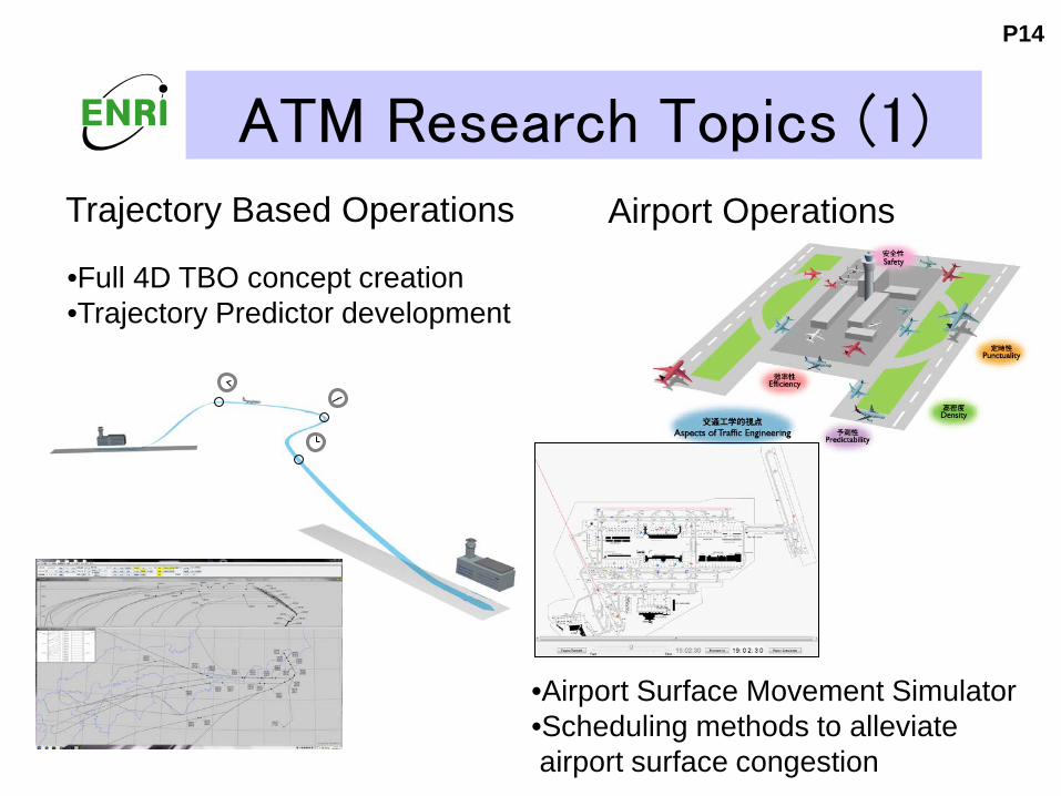
ATM Research Topics (1)
•Full 4D TBO concept creation •Trajectory Predictor development
P14
Trajectory Based Operations Airport Operations
•Airport Surface Movement Simulator •Scheduling methods to alleviate airport surface congestion
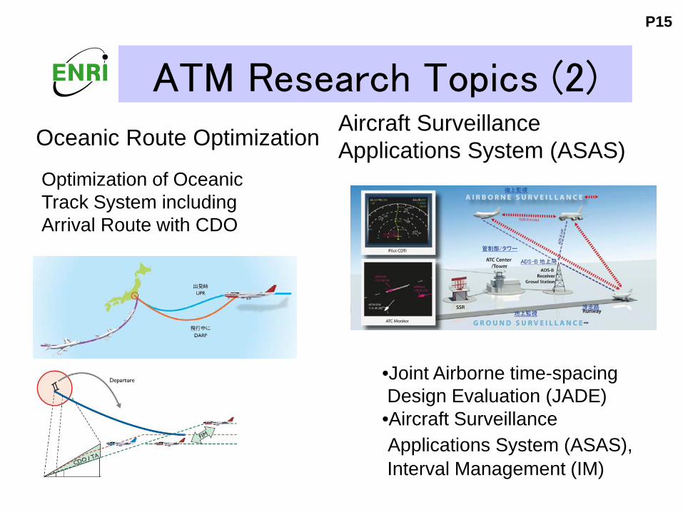
ATM Research Topics (2)
Optimization of Oceanic Track System including Arrival Route with CDO
•Joint Airborne time-spacing Design Evaluation (JADE) •Aircraft Surveillance Applications System (ASAS), Interval Management (IM)
P15
Oceanic Route Optimization Aircraft Surveillance Applications System (ASAS)
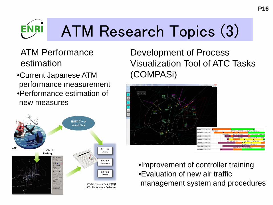
ATM Research Topics (3)
•Current Japanese ATM performance measurement •Performance estimation of new measures
P16
ATM Performance estimation
Development of Process Visualization Tool of ATC Tasks (COMPASi)
•Improvement of controller training •Evaluation of new air traffic management system and procedures
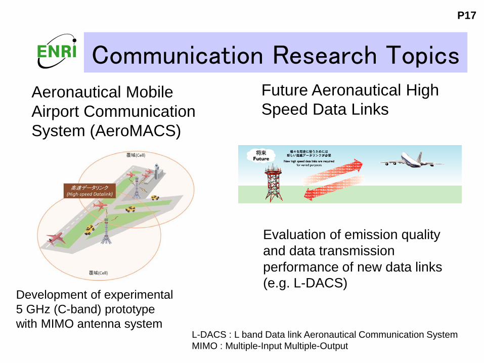
Communication Research Topics
Development of experimental 5 GHz (C-band) prototype with MIMO antenna system
L-DACS : L band Data link Aeronautical Communication System MIMO : Multiple-Input Multiple-Output
Future Aeronautical High Speed Data Links
P17
Aeronautical Mobile Airport Communication System (AeroMACS)
Evaluation of emission quality and data transmission performance of new data links (e.g. L-DACS)
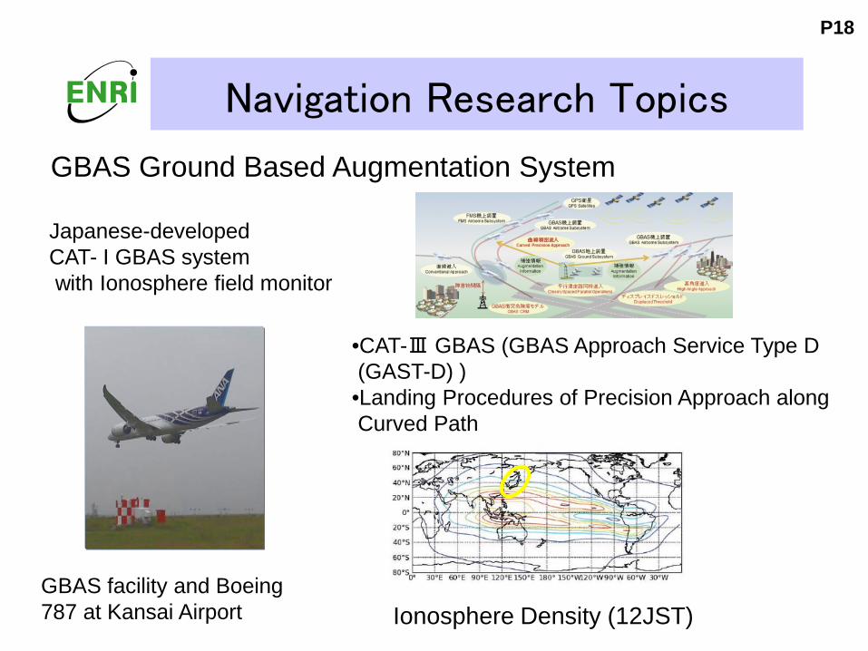
Navigation Research Topics
GBAS facility and Boeing 787 at Kansai Airport
GBAS Ground Based Augmentation System
Ionosphere Density (12JST)
•CAT-Ⅲ GBAS (GBAS Approach Service Type D (GAST-D) ) •Landing Procedures of Precision Approach along Curved Path
P18
Japanese-developed CAT- I GBAS system with Ionosphere field monitor
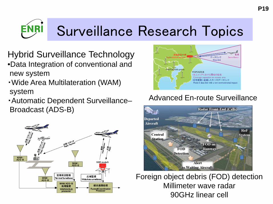
Surveillance Research Topics
Foreign object debris (FOD) detection Millimeter wave radar
90GHz linear cell
Hybrid Surveillance Technology •Data Integration of conventional and new system ・Wide Area Multilateration (WAM) system ・Automatic Dependent Surveillance– Broadcast (ADS-B)
Advanced En-route Surveillance
P19
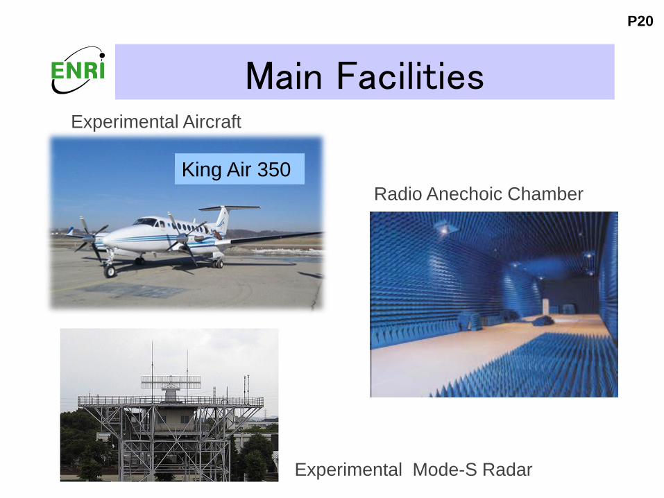
Main Facilities
Radio Anechoic Chamber
Experimental Mode-S Radar
King Air 350
Experimental Aircraft
P20
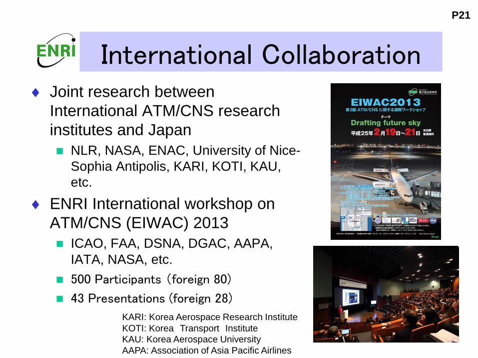
International Collaboration ♦ Joint research between
International ATM/CNS research institutes and Japan NLR, NASA, ENAC, University of Nice-
Sophia Antipolis, KARI, KOTI, KAU, etc.
♦ ENRI International workshop on ATM/CNS (EIWAC) 2013 ICAO, FAA, DSNA, DGAC, AAPA,
IATA, NASA, etc. 500 Participants (foreign 80)
43 Presentations (foreign 28)
P21
KARI: Korea Aerospace Research Institute KOTI: Korea Transport Institute KAU: Korea Aerospace University AAPA: Association of Asia Pacific Airlines
Conclusions
♦ CARATS, JCAB long-term vision Eight Pillar of Renovations on ATM/CNS CARATS road maps to realize the concepts Sub-committee for Promoting Research and
Development ♦ ENRI major research topics on ATM/CNS
TBO, Airport operation, Oceanic Route Optimization, ASAS, ATM performance, Visualization Tool of ATC Tasks
High Speed Data Links, GBAS, Hybrid Surveillance, FOD detection
♦ ENRI is contributing to CARATS in both near and long term basis.
P22