Embed Size (px)
Citation preview
Atkins Danmark A/S
Pulse Comes to You

05/05/2009
NameDan Sander Petersen
Maximo ReferenceBanedanmark, Rail Net Denmark
Jernbaneverket, The Norwegian National Rail Administration
Vejdirektoratet, Danish Road Directorate
SessionGeographic information systems (GIS) and Maximo Spatial
Business PartnerAtkins is Business partner with IBM and ESRI

05/05/2009
Agenda
Atkins introduktion
Geographic information systems (GIS) in general
Customized Maximo - GIS integration with a demo
Maximo Spatial – ESRI integration with a Use case and demo

Atkins Danmark A/S

05/05/2009
PlanAtkins plans all aspects of our clients’ projects.
DesignAtkins designs optimal systems, processes, buildings and civil structures.
EnableAtkins enables complex programmes by providing unique solutions to reduce timescales, cost and disruption.

05/05/2009
Atkins plc
• Architecture• Construction• Environment• Health• Industry
• Energy supply• Transport and infrastructure• Aviation• Communication technology
Atkins plc is a multidisciplinary consultancy which provides services for a variety of sectors, including:
Atkins plc is� the largest multidisciplinary consultancy in Europe� the world’s fifth largest international design firm

05/05/2009
Total: 18.000 people
Atkins international

05/05/2009
Atkins in Scandinavia
In Denmark we have offices in Copenhagen (head office), Århus and Esbjerg.
Atkins Sweden AB is a subsidiary of Atkins Danmark and has offices in Stockholm, Malmø, Västerås, Gothenburg and Helsingborg.
S
W
E
D
E
N
N
O
R
W
A
Y
DENMARK Århus
Copenhagen
Oslo
Malmö
Göteborg
Stockholm
Västerås
Esbjerg

05/05/2009
Staff and annual turnover
StaffAtkins Denmark: 310Atkins Sweden: 130Atkins plc: 18.000
Annual turnover 2007/2008Atkins Denmark: 233 MDKKAtkins Sweden: 77 MSEKAtkins plc: £ 1.313 M

05/05/2009
Industry Environment & GIS
Management
Core activities
Rail

05/05/2009
GIS Geographic Information Systems
In our modern information society we use GIS to make data accessible
Our capabilities include:• GIS analyses • Environmental GIS• Mobile GIS• Map and geodata • Web-based map solutions• User research• Software development• Databases• Asset Management
Geographic information systems (GIS) in general

05/05/2009
GIS technologyGIS technology are used by an growing range of users on systems like Google Earth or Navigations tools
GIS systems moves from single departmental, desktop-based solutions based on proprietary architectures to Web-based 2-D and 3-D
05/05/2009
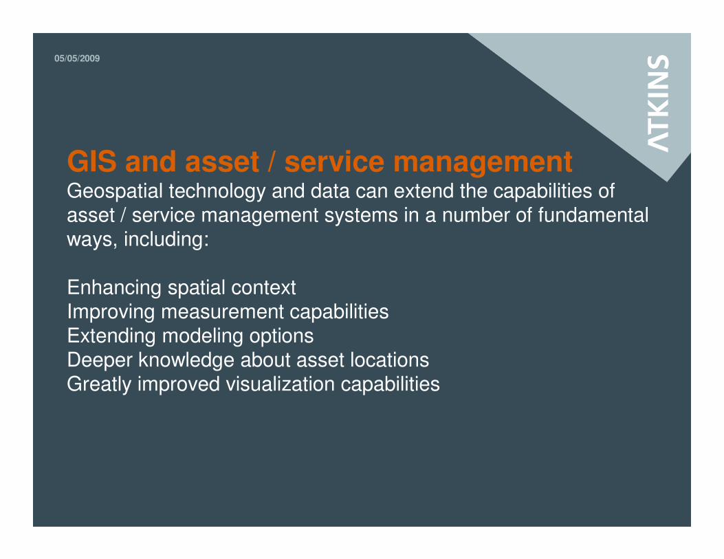
GIS and asset / service management Geospatial technology and data can extend the capabilities of asset / service management systems in a number of fundamental ways, including:
Enhancing spatial contextImproving measurement capabilitiesExtending modeling optionsDeeper knowledge about asset locationsGreatly improved visualization capabilities

Costumized Maximo - GIS integration with a demo

05/05/2009
An Customized Maximo GIS integrationThe system configuration:
Asset Management(Maximo)
Reports (Actuate)
GIS system(MapServer)
Objekt dbMaterialised
view

05/05/2009
Recorded demo The recorded demo is showing an Maximo GIS integration based on open source GIS.

Maximo Spatial – ESRI integration with a Use case and demo

05/05/2009
Maximo Spatial Asset ManagementMaximo Spatial Asset Management is a geospatially enabled asset management solution that makes the power of desktop GIS directly available to enterprise asset management users
It offers a seamless user experience that incorporates map-based user interfaces, dynamic access to GIS data in the Maximo application

05/05/2009
Key features of Maximo Spatial Asset Management• Any Maximo entity can be spatially enabled: Assets, Service Requests, Locations, Work Orders, Tools, Materials, Labor, etc•Valid Asset and location types: Linear (roads, rails, pipelines, power lines, waterways); Area/Polygon (buildings, roofs, forests, service areas, campuses, offices); and Points (poles, hydrants, meters, signs, transformers,houses)•Supports geo-coding.•Supports tracing networks, direction of “flow” of the gas, water, electricity, etc.•Supports enhanced routing or route planning capabilities.•Edit GIS-based data elements from within the familiar Maximo software interface.•No need to set up special security for Maximo Spatial.•GIS data entered in the Maximo application can be edited by the standard ESRI desktop applications.

05/05/2009
Maximo Spatial architecture

05/05/2009
Use caseThe use case is showing a typical Service request use of Maximo and GIS.

05/05/2009
Creating a Service Request using geospatial data
Go to Maptab to showlocation ofwater
Simplescreen forservicerequests
User ReportedPriority can bereprioritizedby WorkManager later
05/05/2009
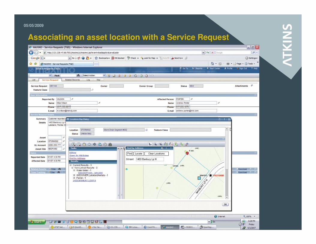
Associating an asset location with a Service Request

05/05/2009
Displaying the boundaries of a Service Request
05/05/2009
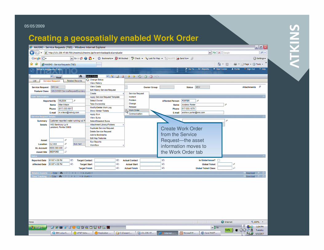
Creating a geospatially enabled Work Order
Create Work Orderfrom the ServiceRequest—the assetinformation moves tothe Work Order tab

05/05/2009
Looking for related work
Query for1453 BanburyLane
05/05/2009
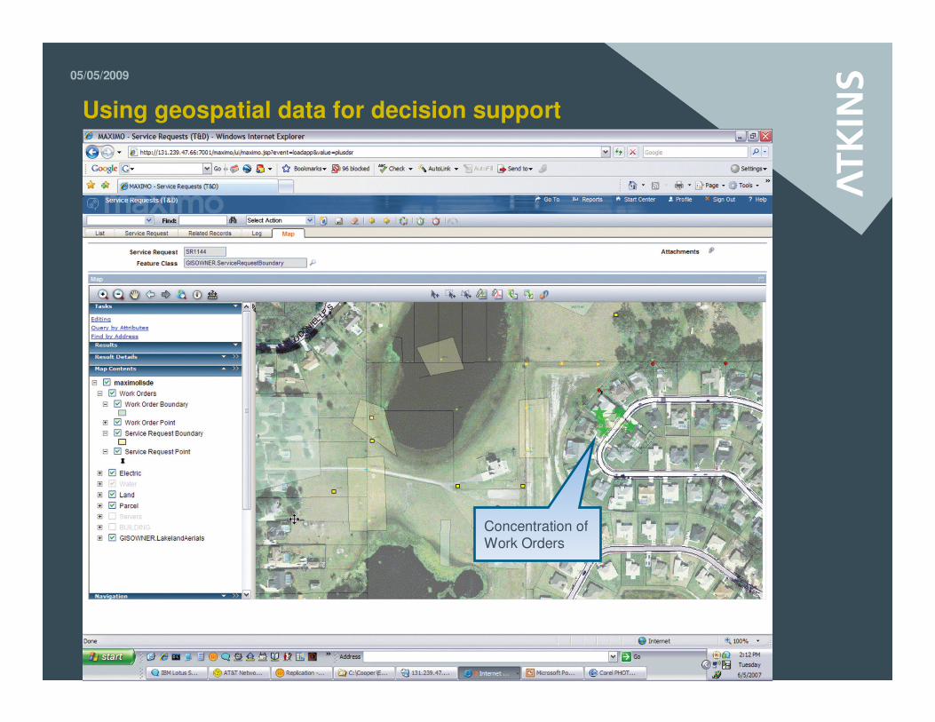
Using geospatial data for decision support
Concentration ofWork Orders

05/05/2009
Demo of Maximo Spatial Asset ManagementThe demo is showing the Asset application with GIS.

05/05/2009
Any Question?
05/05/2009
Contact
Dan Sander PetersenAtkins Danmark A/SArne Jacobsens Allé 172300 Copenhagen SPhone +45 82 33 94 71Mail [email protected]
[email protected] www.atkinsglobal.com