Embed Size (px)
Citation preview
________________________________________________________________________ Massachusetts GIS Strategic Plan 1 June, 2007
Assessors Parcels – Areas of Critical Environmental Concern - Water Mains - Freight
Groundwater Discharge Permits - Facilities w/ Air Operating Permits - Hazardous
Railroads - Prisons - Town Halls - Public Waterway Access - Stream Gauging
Stations - 1995 Black and White Aerial Photos – Crime Locations - Aerial Photos –
Town Halls - USGS Topographic Maps - Public Water Supplies - Wetlands and
Streams - Flood Zones - Aquifers - Sole Source Aquifers - Land Use - Surficial
Geology - Major Watersheds - County Boundaries – Town Boundaries - Water
Valves - Wellhead Protection Zones – Crime Locations - Rapid Transit Lines and
Stops - Regional Planning Agencies - Underground Storage Tanks - Ground Water
Discharges - Canoe Access - Cranberry Bogs - Aqueducts - Elementary School
Districts - Middle School Districts - High School Districts - Outstanding Resource
Waters - Coastal Zones - Zoning District Outlines - Barrier Beaches - Areas Affected
by Title 5 – Regional Planning Agency Boundaries - Sewer Mains - Designated
Shellfish Growing Areas - Ocean Sanctuaries - Ferry Routes - Fire Stations - Marine
Hazardous Waste Sites - Endangered Plant Habitats - Endangered Wildlife Habitats -
Sewered Areas - Surface Water Supply Protection Zones - Transfer Station Facilities
- Commuter Rail - Power Transmission Lines by Type▪ DEP Water Quality Monitoring
Stations - Zoning by Primary Use - Area Codes - Roads - Rare Species Habitat -
Certified Vernal Pools - Major Surface Waters - Police Stations - Protected Open
Space - MWRA Service Areas - Prime Farmland Soils - Building Outlines - Bicycle
Trails - MEMA Regions - Building Footprints - Lobster Harvest Zones Scenic
Landscapes - Long Distance Trails - State Registry of Historic Places - Land Use
Change 1971-1985 - Land Use Change 1971-1999 - Land Use Change 1985-1999 -
Airports - Potential Vernal Pools - Schools - Hospitals and Emergency Room
Facilities Public Water Supply Service Territories - Cable TV Service Territories -
Electricity Service Territories - Natural Gas Service Territories - Quabbin
Preparedness Regions▪ Long Term Care Residences - Colleges - Stewardship
Program Properties - Large Quantity Generators of Hazardous Waste - Facilities w/
A Strategic Plan for Massachusetts’
Spatial Data Infrastructure
June 30, 2007

This page intentionally left blank

Prepared by:
In Collaboration with MassGIS
For:
The Massachusetts Geographic Information Council Strategic Plan Steering Committee
With financial support from:
United States Department of the Interior U.S. Geological Survey
Cooperative Agreement Assistance Award No. 06ERAG0086
June 30, 2007

GIS Strategic Plan Steering Committee1
Co-Chairs: David Beck, Chair, GIS Committee Massachusetts Association of Assessing Officers Niels LaCour, Senior Planner Town of Amherst -------------------------------------------------------------------------------------------------------------------------- Jeff Amero, GIS Manager City of Cambridge Lynn Bjorklund USGS Liaison to CT, RI, MA, & NH US Geological Survey Tim Brennan, Executive Director Pioneer Valley Planning Commission Christine Clarke, State Conservationist USDA-Natural Resource Conservation Service Richard Cohane, Director of GIS Services Control Point Technologies Karen Cullen, Director Development and Inspectional Services Town of Spencer David Davies, Director Information Technology DOR-Division of Local Services Marc Draisen, Executive Director Metropolitan Area Planning Council Lynne Fielding, GIS Specialist Town of Westwood Andrew Finton, Director Conservation Science Massachusetts. Chapter, The Nature Conservancy Shaun Fitzgerald, President Massachusetts Board of Real Estate Appraisers Kurt Gaertner, Director Sustainable Development Executive Office of Energy and Environment Rich Gosselin, Chair, GIS Committee Mass. Assoc. Land Surveyors & Civil Engineers Dick Howe, Register of Deeds Northern Middlesex Registry of Deeds Christian Jacqz, Director, MassGIS Executive Office of Energy and Environmental Affairs Sara Kustron, GIS Coordinator DPH-Center for Environmental Health Steve Mabee, State Geologist UMASS-Amherst Lauren McLane Emergency Management Program Specialist Federal Emergency Management Agency Ken Miller, PE, Deputy Secretary for Planning Executive Office of Transportation and Public Works Dan Nvule, Senior Program Manager Mapping, Modeling & Data Management Massachusetts Water Resources Authority Major Dermot Quinn, Commanding Officer State Police, Commonwealth Fusion Center Jennifer Ryan, Assistant Director Legislative Affairs Massachusetts Audubon Society Ric Skinner, Manager Health Geographics Program Baystate Medical Center John Tommaney, Chief Response and Recovery Branch Massachusetts. Emergency Management Agency Robert Wilbur, Chief Information Officer Executive Office of Energy and Environment
1 Since their participation on the Steering Committee, some individuals have changed jobs or left the organization with which they are affiliated on this list.
________________________________________________________________________ Massachusetts GIS Strategic Plan 2 June, 2007

Table of Contents
Executive Summary.......................................................................................................................4
1 The GIS Strategic Planning Process in Massachusetts ................................................... 10
1.1 Background................................................................................................................... 10
1.2 Federal Grant and Interagency Coordination Efforts.................................................... 11
1.3 Why Massachusetts Needs a Plan................................................................................. 12
1.4 Focus on Key Data Layers – Why These? Why Not Others?....................................... 17
1.5 Outreach & Information Gathering............................................................................... 18
2 Current Situation – Strengths, Weaknesses, Threats, Opportunities............................ 20
2.1 General Strengths and Weaknesses of GIS in Massachusetts ...................................... 20
2.2 Orthophoto and Elevation data ..................................................................................... 23
2.3 Streets and Linear Address Ranges............................................................................... 27
2.4 Parcel Mapping ............................................................................................................. 32
2.5 Critical Infrastructure.................................................................................................... 38
3 Vision, Goals and Recommendations ................................................................................ 42
3.1 Vision for a Massachusetts Spatial Data Infrastructure................................................ 42
3.2 Recommendations to Advance the Development of a Massachusetts Spatial Data Infrastructure ................................................................................................................ 44
4 Implementation of a Massachusetts Spatial Data Infrastructure .................................. 58
4.1 Current Hardware/Software .......................................................................................... 58
4.2 Data Requirements........................................................................................................ 59
4.3 Technology Requirements ............................................................................................ 60
4.4 Resource Requirements and Overall Funding Strategy ................................................ 60
4.5 Standards....................................................................................................................... 65
4.6 Organizational Requirements........................................................................................ 68
4.7 Policies and Mandates................................................................................................... 69
4.8 Staffing and Budget Requirements ............................................................................... 72
APPENDIX A:............................................................................................................................. 72
________________________________________________________________________ Massachusetts GIS Strategic Plan 3 June, 2007
Executive Summary A geographic information system (GIS) is a computerized system used to create, store, manage, analyze and display maps and associated data. Like other database technologies, GIS is increasingly deployed on the World Wide Web. Commercial examples include systems such as MapQuest, Yahoo Maps and Google Earth.
A survey of GIS in Massachusetts shows that this technology offers considerable benefit in supporting operations, setting priorities and developing policies at all levels of government. It also reveals substantial benefit in the use of GIS by the private sector, both in delivering services to government entities and in providing a competitive advantage for the Massachusetts economy. But these benefits can only be fully realized if core GIS resources are recognized as infrastructure, a shared platform on which multiple agencies and businesses build applications to support their specific missions. The report focuses on these core resources, the geospatial data infrastructure, including illustrative examples of where and how key data sets are used. It concludes with recommendations for the technical and institutional arrangements needed to ensure the continued development of GIS as a sustainable and vibrant part of the Commonwealth’s technology landscape.
The analysis and the recommendations made in this plan are offered in the context of the following goals for the use of information technology in government:
• Avoid wasteful and redundant expenditures • Improve communication and cooperation between levels of government • Maximize value through standards and economies of scale • Take advantage of the Internet to provide broad access to information resources • Provide technical assistance to communities • Make regulatory processes more efficient
With careful planning and effort, GIS technology can help Massachusetts reach these goals. Current GIS Use in Massachusetts The first use of GIS in Massachusetts state government was in 1986; currently multiple executive offices and departments use this technology to support a wide variety of environmental, transportation, public health and public safety programs. For example:
• The Department of Environmental Protection uses GIS to help identify Wetlands Protection Act violations and to initiate revenue-generating enforcement actions.
• The Executive Office of Transportation and Public Works (EOT) uses GIS to maintain a comprehensive inventory of roadways and to track crashes. Both of these activities are required for Federal Highway Administration funding eligibility.
• The Department of Public Health has used GIS technology to help monitor periodic outbreaks of eastern equine encephalitis and to plan for the aerial spraying used to control mosquito populations during these outbreaks.
• The Massachusetts Emergency Management Agency uses GIS to map critical infrastructure and to help each of the 351 cities and towns in the Commonwealth prepare and maintain their comprehensive emergency management plans.
MassGIS, officially known as the state’s Office of Geographic and Environmental Information, was created by legislation in 1999 within the Executive Office of Energy and Environmental Affairs (EOEEA) to oversee shared aspects of the state’s GIS and to provide statewide coordination. Its functions include:
• Collecting and storing the Commonwealth’s spatial data assets: over 150 individual data layers – from wetlands to roadways to census boundaries to schools - are currently available to GIS users.
________________________________________________________________________ Massachusetts GIS Strategic Plan 4 June, 2007

• Maintaining technology infrastructure to provide access to those data assets: in 2007 it is estimated that over 4.5 terabytes of GIS data will be downloaded and over 5.7 million map images will be generated using the MassGIS infrastructure.
• Leading cooperative efforts to create and maintain base data that are used by multiple departments
• Setting GIS standards that are used by state agencies, regional planning agencies, and municipalities
• Actively coordinating the Commonwealth’s GIS efforts with those of local government and the federal government
There are approximately 65 GIS professional positions in state government and an annual expenditure of approximately $4.75 million on personnel and software licensing. Outside of state government, every regional planning agency (RPA) and over 150 cities and towns have deployed GIS technology to manage mapped information and to support planning and decision making. Examples abound: the Town of Hull uses GIS in assessing; the City of Salem maintains its zoning map in GIS; the City of Pittsfield uses GIS to help manage its utility infrastructure. In total, an estimated $5.6 million is spent on GIS staffing and software annually by the RPAs and local governments. Furthermore, the combined total expenditure on GIS data development over the last seven years is estimated at an additional $20 million. In the private sector, entities ranging from public and private academic institutions to non-profit conservation organizations to engineering, planning and real estate development firms download and use the Commonwealth’s GIS data on a daily basis.
Over the past 20 years the use of GIS has steadily grown. As a result there are greater demands being placed on the Commonwealth’s spatial data infrastructure and a greater need for coordination to ensure efficient and effective resource allocation going forward.
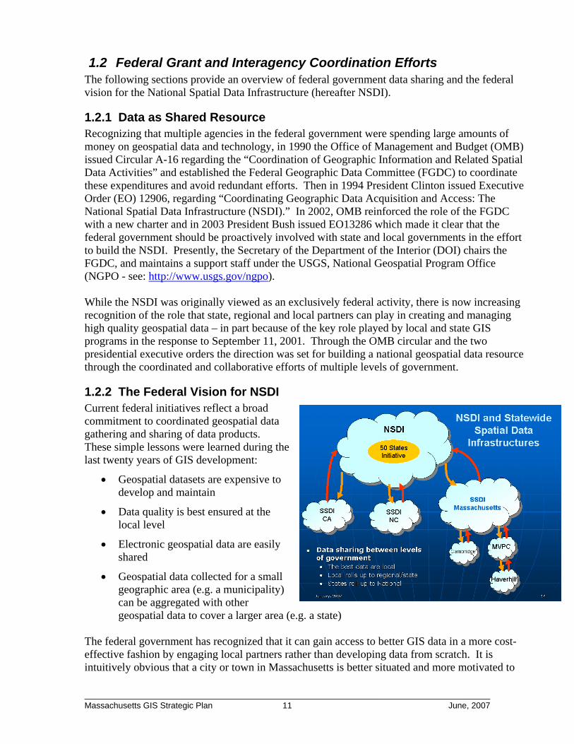
National Picture and Project Funding Massachusetts is not alone in reexamining its GIS infrastructure after 20 years of steady increase in operational use. The federal government, with a similar milieu of numerous departmental GIS programs, has also recognized the need for interagency coordination and long-term planning. Beginning in 1990 the Office of Management and Budget, via Circular A16, created the Federal Geographic Data Coordinating Committee (FGDC) expressly to promote increased coordination and efficiency between federal GIS programs. As a result, the FGDC launched an ambitious initiative to build a National Spatial Data Infrastructure (NSDI) that would provide a detailed, comprehensive digital map of the country.
In the aftermath of high profile, multi-state disasters such as 9/11 and Hurricane Katrina there has been an increased federal focus on GIS data as an element of preparedness, and also a pragmatic recognition that the best data are to be found at state and local levels of government. Simply put, the Town of Westborough can be expected to have a better map of its own roads than could be produced at the federal level. As the figure to above illustrates, data can be collected locally and then aggregated to the state and national levels. Consistent with this understanding, President Bush issued Executive Order 13286 in
________________________________________________________________________ Massachusetts GIS Strategic Plan 5 June, 2007

2003 that specifically broadened the FGDC’s NSDI mandate to include efforts aimed at enlisting states to help create and maintain the NSDI.
Part of the FGDC strategy has been to provide funding to states that were interested in building Statewide Spatial Data Infrastructures (SSDI) to feed the NSDI. The first round of funding was for state-level GIS strategic planning efforts and in 2006 Massachusetts received such a grant. This GIS Strategic Plan is the result.
Strategic Planning Process The Massachusetts GIS Strategic Planning process was consciously designed to include the broadest possible GIS stakeholder input. This was done in three ways:
1. Strategic Planning Steering Committee: The process was overseen by a Steering Committee that represented 26 different agencies from state, local and federal governments, RPAs, academia, not-for-profits and the private sector.
2. Stakeholder Workshops: Six open workshops were held throughout the state to discuss the strengths and weaknesses of GIS operations in Massachusetts, and to suggest potential improvements. Over 220 individuals participated in these sessions.
3. Key Stakeholder Interviews: 22 interviews were conducted that included over 65 individuals from that represented strong GIS programs, key decision makers and/or important GIS user constituencies.
Following the collection of stakeholder input, the vision, findings and recommendations presented in this report were developed.
Vision for a Massachusetts Spatial Data Infrastructure The fully developed vision for a Massachusetts Spatial Data Infrastructure (MSDI) encompasses:
• Strong coordination among state departmental GIS programs to capture synergies and avoid redundancies and inefficiencies
• Management of the GIS infrastructure in close alignment with the Commonwealth’s overall information technology infrastructure
• Active communication and coordination between state GIS efforand local, regional and federal GIS efforts to ensure smooth, two-way data sharing. Regiona entities can play a key role in providing technical suand outreach to the local lev
ts
pport el.
• Maintenance and support of a reliable, high performance spatial data repository and associated web services for disseminating spatial data
• Rich and accurate spatial databases including new capital initiatives to develop statewide parcels, addresses and high resolution elevation data
• Sustainable funding to support data maintenance, including regular updating of core, base datasets such as aerial imagery.
• Adequate sustainable funding to support MassGIS’s technology development, spatial data management and intergovernmental coordination missions
________________________________________________________________________ Massachusetts GIS Strategic Plan 6 June, 2007

Findings on Strengths and Weaknesses
The following represent key findings in support of the report’s recommendations:
• MassGIS gets high marks: Overall, MassGIS received extremely favorable ratings across the stakeholder community. Through its efforts and those of other agencies, the Commonwealth has assembled an impressive array of statewide data sets. MassGIS has also achieved national recognition for innovation in making these data accessible. In addition, MassGIS works hard to coordinate its activities in standards development and project design with local governments, RPAs and other stakeholder groups.
• Statewide aerial images (orthophotos) have become a core data asset that requires a systematic, regular update cycle: Over the past 10 years MassGIS has led three separate statewide orthophoto projects: 1994-1997, 2001 and 2005. Each of these projects was put together with creative financing involving many other partners such as the Department of Environmental Protection, EOT, MWRA, the Department of Public Health and even private utilities. These aerial images are used on a daily basis throughout the stakeholder community. However, for imagery to be useful it needs to be current and there is strong consensus on the need for a regular, three-year update cycle.
• Statewide parcel data are critical: Parcel data was identified as the largest existing GIS data gap. Such data are required for activities ranging from open space acquisition to road corridor planning to emergency response and public health monitoring. Currently, parcel maps are developed and maintained independently by the 351 cities and towns in the Commonwealth. Approximately, 200 communities have electronic versions of their parcel maps which can be used in a GIS, but these are in a variety of formats and it is very difficult to assemble regional, much less statewide parcel mapping.
• Statewide address locations are required: Myriad activities and responsibilities of state government are linked to a physical address, ranging from environmental permitting to day care licensing to police and fire response. Using GIS technology, it is possible to geocode or automate the mapping of address locations. This can help agencies deliver services more rapidly and effectively, analyze patterns and identify constraints or opportunities in combination with other layers of GIS information. However, this all depends on having high quality geocoding data. Currently available data sets were identified as inadequate and in need of improvement, particularly in a public safety context.
• Better elevation data are required: Currently, the best available elevation data in Massachusetts are 10 foot topographic contours. These data are wholly inadequate to meet a wide variety of environmental and public safety needs facing the Commonwealth including: floodplain mapping, development suitability assessment, planning for global climate change and sea level rise.
• Critical infrastructure data development needs better coordination: Critical infrastructure mapping has been identified by the U.S. Department of Homeland Security as an important priority for emergency preparedness. To date, Massachusetts has been engaged in numerous critical infrastructure data collection efforts and is making notable progress at assembling these data for elements such as hospitals, schools, prisons and day care centers. Even so, these efforts could be better coordinated and there has been duplication of effort and lost opportunities to develop and implement standards.
• The current model for management and governance of statewide GIS activities has some weaknesses: In spite of its broad, multi-agency coordinating mission MassGIS remains within a small Executive Office with a focused environmental policy and regulatory agenda. Although MassGIS has been successful under this governance model there may be opportunities for
________________________________________________________________________ Massachusetts GIS Strategic Plan 7 June, 2007

improved effectiveness and better alignment with the Commonwealth’s overall information technology policy via alternative models.
Recommendations The report identifies two overall objectives for GIS in the Commonwealth:
1. Improving the Commonwealth’s data assets by upgrading accuracy and currency and filling-in identified data gaps
2. Evolving GIS governance and funding models to better support GIS infrastructure management and intergovernmental coordination
There are eight specific recommendations to further these objectives:
1. Develop regular three-year update cycle for aerial photography: This program would involve approximately $1M in expenditure over a three year cycle to create detailed, statewide aerial imagery (color orthophotos). This product complements the oblique imagery currently funded by EOT and Executive Office of Public Safety and Security ( EOPSS) by providing a geographically accurate basemap and supports the generation of derivative products such as impervious surface and land use mapping.
2. Develop improved elevation data: Use state-of-the-art airborne “LiDAR” sensors to develop elevation data that provides 2 foot contour accuracy. This project should be synchronized with the aerial imagery project since elevation data are required to produce any aerial images.
3. Standardize and improve the process for updating the statewide roads data: The GIS map of roads is currently being maintained through an innovative partnership between Navteq,, Inc. (NAVTEQ), a national supplier of commercial data for onboard navigation and internet mapping, and three state agencies: EOEEA/MassGIS, EOT and the EOPSS/E911. Although this program is working well, it needs better cooperation from local governments in identifying new road construction to EOT in a timely fashion. Regional entities could play a key role in improving local cooperation. Also, adding to the traffic count data available through EOT’s road inventory and developing standards for roads data will help facilitate data exchange between local and state levels.
4. Development of a statewide parcel data layer: The Commonwealth should initiate a capital program to create a statewide parcel data set. Besides creating a a valuable data resource for use in state government and in the private sector, this would help bridge the digital divide between communities that currently have parcel data and those that do not. Such a program would involve two main components. First, new data automation would need to be funded for the approximately 150 “have-not” communities that don’t yet have electronic parcel data. Second, incentive funding would be provided to approximately 150 additional “have” communities to help standardize their data and bring them up to the MassGIS Level II statewide parcel standard. It should be noted that approximately 50 communities have already received incentive funding and have parcel data that conforms to the statewide standard. As with the roads data, a program of outreach, education and technical support administered regionally can help ensure the success of this effort.
5. Develop a statewide address point data layer: The Commonwealth should begin detailed planning to create a statewide address point data set, including developing and disseminating standards and best practices for address assignment. Since the E911 program would be a major beneficiary of improved addressing, use of the existing E911 phone surcharge to fund this effort should be considered. Note that complete address information will also be important for ensuring a correct population count for the Federal Census in 2010. The parcel development work described above would provide a valuable resource for building this data set and could help
________________________________________________________________________ Massachusetts GIS Strategic Plan 8 June, 2007

contain initial development costs. Again, education and outreach are key components of this effort.
6. Aggressively pursue federal grant funds to support statewide critical infrastructure data development: Development of statewide critical infrastructure data sets has been identified as an eligible use for several federal homeland security grant programs, and federal officials have indicated an availability of funds. Massachusetts should strongly consider preparing a grant application to support further critical infrastructure data collection efforts. Such a grant would fund the remaining work of: 1) consolidating and standardizing existing critical infrastructure data holdings, and 2) prioritizing and filling remaining critical infrastructure data gaps.[Note: since this report was prepared, EOPSS has requested this type of funding in their Homeland Security funding application. EOPSS has also released the State Homeland Security Report; one objective in that report is, “Enhance Geographic Information Systems Capabilities”. Implementing this objective includes coordination between an EOPSS working group and MassGIS ]
7. Strengthen GIS technical support provided to local government via regional entities: Several of the recommendations above involve further outreach and collaboration with local governments to help in the task of assembling and maintaining key data sets such as addresses, parcels and roads. Helping communities better understand and implement GIS technology at a local level will be an important prerequisite for effective integration of local data into a statewide resource. Given the size of the state, the Commonwealth should provides funds through MassGIS for regional partners to provide GIS technical assistance to local governments.
8. Explore the further evolution of MassGIS’s organization model and governance structure: While the MassGIS office is already recognized as the lead GIS agency for the Commonwealth, its location in EOEEA makes it hard for legislators and decision-makers to understand that MassGIS is a resource for all state agencies, and indeed all levels of government. Further, there is no formal relationship between MassGIS and state Chief Information Officer (CIO), and thus MassGIS can be “out of the loop” regarding the Commonwealth’s overall information technology policy and planning. The report describes in detail three potential models for addressing these shortcomings.
The full Strategic Plan document identifies the funding requirements, as well as potential revenue sources for all the recommendations presented above. Completing these recommendations is estimated to require between $6,000,000 and $8,000,000 in one-time, capital expenditures, largely for new data creation. Several recommendations require annual funding across multiple agencies. These annual expenditures are estimated to cost between $2,500,000 and $3,650,000; they include the current annual MassGIS operating budget. Conclusion Massachusetts has made substantial headway in developing and deploying GIS technology in government. A series of well considered strategic investments will help to fill in existing data gaps, to improve governance and to position Massachusetts to capitalize on federal support for participation in the NSDI.
________________________________________________________________________ Massachusetts GIS Strategic Plan 9 June, 2007

1 The GIS Strategic Planning Process in Massachusetts
1.1 Background
1.1.1 Introduction – Strategic Planning Process This document presents a strategic plan for developing shared geographic information system (GIS) data resources within Massachusetts government agencies. Funding for this plan came from a grant through the Fifty States Initiative of the United States Geological Survey (USGS). MassGIS, as the lead agency for GIS coordination, received the grant and managed the project. The Fifty States Initiative is a national approach to spatial data management which builds on the collective efforts of all the states and the purpose of the grant is to support state level GIS program planning and development. With advice from the existing Massachusetts Geographic Information Council (MGIC), MassGIS organized a Steering Committee representing a broad array of GIS stakeholders in Massachusetts to provide overall input and direction for the project. A consultant, Applied Geographics, Inc. (AppGeo) of Boston, was selected through a competitive procurement to gather information and author the plan. Their qualifications include development of the strategic plan template that is being used nationally for the Fifty States initiative and ongoing consulting work on strategic plan development in a number of other states. The plan development is described below – it included a series of workshops throughout the state to which all GIS users were invited, followed by targeted interviews with key stakeholders. The members of the Steering Committee provided input throughout the project – by attending workshops, participating in interviews (see Section 1.5) and meeting as a group to review and comment on a draft of this report.
1.1.2 MassGIS History and Legislative Mandate In the late 1980s, the Executive Office of Environmental Affairs, now known as the Executive Office of Energy and Environmental Affairs (EOEEA), initiated a multi-department technology integration project based on an agency-wide vision for information management. In 1988, as part of the effort to consolidate and modernize systems, EOEEA broadened the scope of the GIS effort then underway at the Hazardous Waste Facility Site Safety Council to include support for all its agencies – this was the beginning of the MassGIS program. In 1999, the State Legislature created2 “The Office of Geographic and Environmental Information” within EOEEA. The Office is still generally known by the acronym “MassGIS”. The legislative mandate includes coordinating GIS activity in the Commonwealth, developing, maintaining, and distributing geographic and environmental information, establishing and implementing GIS data standards, providing technical assistance to the Commonwealth’s agencies, creating a network of regional service centers, and providing grant funding to local and regional public agencies.
2 MGL 21A, §4B
________________________________________________________________________ Massachusetts GIS Strategic Plan 10 June, 2007
1.2 Federal Grant and Interagency Coordination Efforts The following sections provide an overview of federal government data sharing and the federal vision for the National Spatial Data Infrastructure (hereafter NSDI).
1.2.1 Data as Shared Resource Recognizing that multiple agencies in the federal government were spending large amounts of money on geospatial data and technology, in 1990 the Office of Management and Budget (OMB) issued Circular A-16 regarding the “Coordination of Geographic Information and Related Spatial Data Activities” and established the Federal Geographic Data Committee (FGDC) to coordinate these expenditures and avoid redundant efforts. Then in 1994 President Clinton issued Executive Order (EO) 12906, regarding “Coordinating Geographic Data Acquisition and Access: The National Spatial Data Infrastructure (NSDI).” In 2002, OMB reinforced the role of the FGDC with a new charter and in 2003 President Bush issued EO13286 which made it clear that the federal government should be proactively involved with state and local governments in the effort to build the NSDI. Presently, the Secretary of the Department of the Interior (DOI) chairs the FGDC, and maintains a support staff under the USGS, National Geospatial Program Office (NGPO - see: http://www.usgs.gov/ngpo). While the NSDI was originally viewed as an exclusively federal activity, there is now increasing recognition of the role that state, regional and local partners can play in creating and managing high quality geospatial data – in part because of the key role played by local and state GIS programs in the response to September 11, 2001. Through the OMB circular and the two presidential executive orders the direction was set for building a national geospatial data resource through the coordinated and collaborative efforts of multiple levels of government.
1.2.2 The Federal Vision for NSDI Current federal initiatives reflect a broad commitment to coordinated geospatial data gathering and sharing of data products. These simple lessons were learned during the last twenty years of GIS development:
• Geospatial datasets are expensive to develop and maintain
• Data quality is best ensured at the local level
• Electronic geospatial data are easily shared
• Geospatial data collected for a small geographic area (e.g. a municipality) can be aggregated with other geospatial data to cover a larger area (e.g. a state)
The federal government has recognized that it can gain access to better GIS data in a more cost-effective fashion by engaging local partners rather than developing data from scratch. It is intuitively obvious that a city or town in Massachusetts is better situated and more motivated to
________________________________________________________________________ Massachusetts GIS Strategic Plan 11 June, 2007

maintain its digital street map than someone working in Washington DC. The NSDI’s basic premise is for data to flow between the federal government and state and local partners, with data standards ensuring data quality. The graphic above illustrates this vision. NSDI’s initial construction focused on seven “framework” data sets which collectively comprise The National Map. Listed below are the framework data most needed across multiple agencies and the federal agency designated as the lead for each one:
• Geodetic control – National Geodetic Survey • Cadastral (i.e. parcels) – Bureau of Land Management • Orthoimagery – USGS • Elevation – USGS • Hydrography – USGS • Administrative units/political boundaries – U.S. Census Bureau • Transportation – Department of Transportation
As described below, this plan recognizes the importance of The National Map and aligns the Massachusetts approach with the federal vision.
1.3 Why Massachusetts Needs a Plan As noted above, Massachusetts government has been working with GIS technology since 1986. As the lead state agency for GIS coordination, MassGIS has a long and successful track record in building a shared data resource. During that period, however, there have only been a few opportunities to step back from the day-to-day program management and plan strategically for the future. For a variety of reasons, now is the right time for such an effort.
1.3.1 Current GIS Activities and Expenditures are Significant Massachusetts expenditures at all levels of government have risen and presently constitute a significant annual outlay. MassGIS estimates the following annual spending (staff, training, and software licenses) for GIS operations.
Level of Govt.
Estimated FTEs
Estimated $’s
State (EOT, ENV, MEMA, DCAM, DPH, State Police, etc.)
65
$4,750,000
Regional (RPA) 20 $1,350,000 Local (150 cities/towns) 65 $4,300,000 TOTAL 145 $10,400,000
At this level of spending, even small efficiencies gained by improved coordination and cooperation, can result in significant savings. Not only can duplicate efforts creating and managing GIS data be avoided (a pure efficiency benefit), but there are also opportunities for significant economies of scale. When state and local government holdings are combined, the estimated total GIS investment in data is conservatively estimated at more than $20,000,000. Government is not the only user of GIS technology - the private and non-profit sectors are also significant users. In the private sector, there is extensive GIS use in the real estate, environmental services, surveying, and engineering communities. Numerous Massachusetts
________________________________________________________________________ Massachusetts GIS Strategic Plan 12 June, 2007

companies compete vigorously for government projects which include GIS analyses. Having high-quality publicly-available data rebounds to the benefit of the Commonwealth and multiplies the investment benefit. Furthermore, the growth of a robust Massachusetts private-sector capacity in this area can be a competitive advantage for the state at the national level3.
1.3.2 Supporting broad policy goals of the Commonwealth This strategic plan advances several important policy goals. In tight budget times, the plan recognizes the state’s need to avoid redundant expenditures and works to maximize the value of all current and future GIS investments. GIS is meant to help government work “smarter,” more efficiently, and more effectively. To do this by building data resources which are shared across all levels of government requires a coordinated effort. State, regional and local government must work together, so improving communication among levels of government is a key part of this plan. Many workshop participants recommended greater efforts to publicize existing resources. Data development can be viewed as a form of assistance to communities, but it needs to be supplemented by support and training. Although this plan does not focus on details, it suggests that technical assistance take a variety of forms - including direct support, peer networking, procurement assistance, data standards and so on.
Many stakeholders noted that lack of data or discrepancies in GIS data available to local and state authorities led to conflicts, confusion and delays in permitting processes. Making sure that all participants have equal access to the same high-quality information ensures that decision-making is objective, efficient and consistent – and also streamlines the regulatory process. These efforts - to avoid wasteful expenditures, improve communication and cooperation, maximize the value of information technology, take advantage of the Internet, provide technical assistance to communities, and make regulatory processes more efficient – all fit well with the stated goals of the current administration. This map of cancer occurrences at specific addresses near areas that
historically received pesticide applications shows how GIS can be used to investigate exposure to possible environmental risks. From “Modeling historical environmental exposures using GIS: Implications for disease surveillance,” Silent Spring Institute, May 2003 at http://gis2.esri.com/library/userconf/health03/papers/pap3020/p3020.htm
What specifically can GIS do to improve the efficiency and effectiveness of government operations? Here are a few generic 3 In 2006, the U.S. Department of Labor, Employment & Training Administration identified "geospatial" as one of 14 business sectors that are the target of its High Growth Job Training Initiative http://www.doleta.gov/Brg/JobTrainInitiative
________________________________________________________________________ Massachusetts GIS Strategic Plan 13 June, 2007

illustrations of how GIS capabilities are used throughout government. Where are my clients/constituents? Almost every piece of information collected and managed by state agencies is attached to an address. Mapping addresses (called “geocoding”) allows agencies to find these locations in the real world - whether to perform inspections, deliver social services, analyze demographics or identify exposure to environmental hazards (see graphic). The most visible and important geocoding application is 911 – when first responders must find an address in an emergency. Geocoding is also used to locate regional offices, new retail outlets, equipment depots, and other kinds of distribution centers.
Who do we need to inform? Conversely, GIS can help identify people in relation to specific projects or conditions. For example, a very common use of GIS at the local level is to generate “abutter’s lists” – lists of neighbors to a proposed project or incident who need to be notified. This capability to generate a simple list can represent a savings of many hours each time such a list is needed. In a public safety context, there is often a need for “reverse geocoding” – identifying addresses based on proximity to a given location – and it can support a rapid and effective response to incidents requiring evacuation or other pre-emptive action.
What can we tell from an aerial view? Aerial images, more specifically orthophotos, are discussed extensively as a base for GIS activities throughout this report. One example, detailed later, is illustrated to the right - using imagery to detect changes in wetlands. DEP developed an automated process combining aerial imagery and GIS mapping to look for changes within wetland areas over time. In a matter of months, this effort identified hundreds of potential violations and led to enforcement actions totaling hundreds of thousands of dollars, thus serving as an effective deterrent for future illegal activities. EOEEA agencies and their non-profit partners own or manage
________________________________________________________________________ Massachusetts GIS Strategic Plan 14 June, 2007
Identification of abutters on Town of Dedham web site
earlier B&W orthos
2001 color orthos
earlier B&W orthos
2001 color orthos
Change detection to identify potential wetlands violations, DEP

large amounts of undeveloped land, with the attendant responsibility of protecting it from unauthorized use and encroachment. The exterior boundaries of these protected open space parcels add up to nearly 3,000 miles – a daunting responsibility. GIS can show the property’s outline on top of an orthophoto base map and enable agency staff to monitor properties remotely. Even if the GIS mapping does not provide survey-level accuracy for enforcement purposes, it is still good enough to flag any serious looking encroachment, and allow field staff to prioritize their work. Similarly, local assessors can look at changes from one aerial image to another to determine where improvements should trigger the re-valuation of a property. Such automated detection may also support enforcement of building codes, where there may be compliance issues as well as potential to generate new tax revenue. What are our priorities? Where should we invest? Every newly-elected official faces the challenge of defining his or her own set of priorities and reconciling those priorities with the variety of goals and mission statements brought forward at the agency level. GIS technology is ideally suited to integrating data from a variety of disciplines and sources to help target resources in a way that reflects a new set of priorities. GIS supports top-down policy development and decision making as opposed to meeting more narrowly-defined operational needs. For example, GIS data from different departments in the City of Springfield and other sources - including property values, protected open space, zoning, crime reports, building conditions and demographic data - were all used in an analysis for the Executive Office of Administration and Finance to help their staff understand neighborhood issues and potential responses in the context of the City’s financial crisis. GIS highlighted relationships between certain land uses and crime incidence; between open space and property values; and between historic urban redevelopment boundaries and building condition. The immediate benefit of such insights is to support a more effective urban revitalization strategy.
Urban Planning Analyses / City of Springfield (MassGIS with data from Springfield Planning Department)
Tax arrears and urban redevelopment boundaries
Normalized assessed valuation ( $/sq. ft.) and open space
________________________________________________________________________ Massachusetts GIS Strategic Plan 15 June, 2007

On a regional scale, efforts such as the Metro Area Planning Council’s MetroFutures exercise or the Pioneer Valley Planning Commission’s Valley Vision II, have used GIS data on transportation, current land use, zoning, natural resources, demographics and other factors, to identify target areas for more affordable housing and “nodes” for future village centers and other kinds of development consistent with sustainable development priorities. In fact, GIS is the only practical way to integrate the variety of data sources which go into a regional conservation and development plan and to present such plans for public reaction and comment.
Suitable locations for 40R districts, Pioneer Valley Planning Commission
To be credible and useful, all the GIS applications mentioned above, whether narrow in scope or designed to provide a framework of priorities for future investment must be built on a platform of high-quality data as well as GIS software and technical expertise. The strategy for maximizing the usefulness of GIS technology has two necessary components:
1) Create and maintain accurate, standardized, multi-purpose GIS datasets and
2) Provide technical resources to support access at all levels of government This report focuses mainly on the first point – how a few key “layers” should be managed within an overall framework of data sharing. But it also addresses the second point, by suggesting approaches to supporting and maximizing the benefits from widespread GIS deployment.
1.3.3 Room for Improvement in Massachusetts GIS Even though Massachusetts has built a substantial GIS capability over the past two decades, areas for improvement remain. One set of measures of a state’s program effectiveness has been developed by the National States Geographic Information Council (NSGIC – see: http://www.nsgic.org). NSGIC is a national organization oriented toward GIS deployment in state government. In February 2005, NSGIC, in association with the Federal Geographic Data Committee (FGDC – see: http://www.fgdc.gov), published a series of nine criteria “that its members believe are essential for effective statewide coordination of geospatial information technologies”4. These criteria are based on a survey of the most successful statewide GIS programs and they can be helpful in deciding where to seek improvements. In the chart below, Massachusetts scores well on most of the criteria, but not so well in others. The vision and recommendations presented in Section 3 address these shortcomings.
4 NSGIC Newsletter, February 28, 2005; and “Fifty States and Equivalent Entities Involved and Contributing to the NSDI” memo by NSGIC and FGDC.
________________________________________________________________________ Massachusetts GIS Strategic Plan 16 June, 2007

Criterion Status Status Description 1. A full-time, paid coordinator position is designated and has the authority to implement the state’s business and strategic plans.
PARTIALLY
MEETS
Paid director of MassGIS is mandated to support coordination; however, there is no explicit responsibility to implement the state’s strategic plan.
2. A clearly defined authority exists for statewide coordination of geospatial information technologies and data production.
MEETS
Legislative action identified MassGIS as the formal geospatial coordinating body for the Commonwealth.
3. The statewide coordination office has a formal relationship with the state’s Chief Information Office (CIO).
DOES NOT MEET
MassGIS does not maintain a formal relationship with the CIO. However, the CIO does have sign-off on all IT capital budget requests.
4. A champion (politician, or executive decision-maker) is aware and involved in the process of geospatial coordination.
PARTIALLY
MEETS
MassGIS has had key political and executive champions at various times throughout its history, but there has been no strong champion in recent administrations.
5. Responsibilities for developing the National Spatial Data Infrastructure (NSDI) and a State Clearinghouse are assigned.
DOES NOT
MEET
There is no formal responsibility for the NSDI. Massachusetts data are available through The National Map and an operational Clearinghouse node is under development.
6. The ability exists to work and coordinate with local governments, academia, and the private sector.
MEETS
There is strong, active coordination between MassGIS and other stakeholders such as state agencies, local and regional government, academia and the private sector.
7. Sustainable funding sources exist to meet project needs.
PARTIALLY
MEETS
MassGIS has some sustainable funding for core operations, but this covers a small % of annual expenditures. There is no sustainable funding for maintenance of key datasets.
8. GIS Coordinators have the authority to enter into contracts and become capable of receiving and expending funds.
MEETS
MassGIS has the authority to enter into contracts, and to receive and expend funds.
9. The Federal government works through the statewide coordinating authority.
DOES NOT MEET
Numerous state agencies and programs work independently with the Federal government on geospatial matters.
1.4 Focus on Key Data Layers – Why These? Why Not Others? This plan makes strategic recommendations for further development and routine maintenance of four categories of spatial data:
1. An orthophoto, or image basemap, produced from color aerial photography (including infrared) and associated elevation data,
2. Road centerline network with address ranges,
3. Parcels as shown on municipal tax maps and compiled on the orthophoto, and
4. Critical infrastructure locations (geocoded at the parcel/building level.)
________________________________________________________________________ Massachusetts GIS Strategic Plan 17 June, 2007

The first three categories are included in the NSDI “framework spatial data layers” published by the FGDC (see Section 1.2.2 on page 5). The fourth category, critical infrastructure (CI), includes those critical infrastructure facilities and locations identified by the national Homeland Security Infrastructure Program (HSIP) which can readily be associated with a property parcel and/or building based on a street address. Note that the locations of some CI facilities may be sensitive and should not be publicly accessible. Also, many CI
components have already been, or can be, developed from existing GIS data resources. These four categories of data were selected because:
1. They are important – they support a wide variety of activities such as municipal service delivery, natural resource protection, transportation planning, and public safety and emergency response, and
2. Currently there is no long-term plan for their development and maintenance despite their importance.
One important NSDI framework data category that was not prioritized was hydrography (i.e. rivers, streams, ponds and other water bodies). The initial assumption was that the existing maps of surface water features already exist at a scale useful for most purposes and that these data require little maintenance. However, several stakeholders believed that hydrography data improvements were important to priorities such as ensuring adequate supplies of clean drinking water and that an explicit focus on hydrography would have been appropriate in this report. Ultimately, this category was omitted on the pragmatic basis that, while extremely important to specialists involved in water resources, the broader applicability of hydrography improvements across the entire GIS stakeholder community lagged the other four data categories. Thus, inclusion of this fifth category would have expanded the scope of this project beyond what it could support. This omission in no way diminishes the long term importance of the Commonwealth improving its hydrographic data assets.
1.5 Outreach & Information Gathering
Workshops in: Pittsfield West Springfield Lawrence Auburn Wareham Boston
MassGIS initiated this strategic planning project in November 2006. Its advisory board, the Massachusetts Geographic Information Council (MGIC), invited major GIS stakeholders to become members of a Steering Committee for the project. Six half-day workshops conducted in January 2007 solicited input from the full range of public and private organizations with an interest in Massachusetts’ spatial data infrastructure. More than 225 workshop attendees received a project overview and summary of the current status of each data category. Attendees openly discussed user applications, the future vision, challenges, and opportunities.
________________________________________________________________________ Massachusetts GIS Strategic Plan 18 June, 2007

Detailed notes were taken for each discussion and posted on the MassGIS website at http://www.mass.gov/mgis/stratplanNOTES.html. The first meeting of the Steering Committee in February reviewed findings and preliminary recommendations from the workshops. The same material was presented in a series of 20 follow-up interviews (see Appendix A) with senior officials and stakeholder representatives to solicit reactions and additional input. In May 2007 the Steering Committee issued a draft plan for review. Subsequent comments and suggested revisions were incorporated by the consultant into the final plan.
Workshop Attendees by Affiliation
Academic Private
Federal State
Regional Local
Non-Profit
3%
18%
7%
2%
22%42%
7%
Workshop Attendees by Affiliation
Academic Private
Federal State
Regional Local
Non-Profit
3%
18%
7%
2%
22%42%
7%
________________________________________________________________________ Massachusetts GIS Strategic Plan 19 June, 2007

2 Current Situation – Strengths, Weaknesses, Threats, Opportunities
The following outlines the general strengths and weakness of GIS in Massachusetts and then provides a more specific focus on strengths and weaknesses of each of the four data sets.
2.1 General Strengths and Weaknesses of GIS in Massachusetts Since the mid-1980’s, Massachusetts has had a strong and innovative GIS program at MassGIS. Workshop participants gave near unanimous praise for the data and services MassGIS provides to all levels of government. In addition, Massachusetts has received nationwide GIS recognition by winning both the Geospatial Information Technology Association’s (GITA) Innovator Award and the Urban and Regional Information System Association’s (URISA) Exemplary Systems in Government Award. The general strengths of GIS in Massachusetts are:
• GIS is used at all levels of government. Numerous state agencies, every regional planning agency and over 150 cities and towns have deployed GIS.
• The Commonwealth’s data assets are publicly available from a shared data repository at MassGIS. Many state government GIS data sets, as well as some local government data, are freely available for download from the MassGIS web-site. In addition, MassGIS provides public access to these data via a series of web-based “viewers” and also via publicly accessible web services based on the Open GIS Consortium’s Web Map Service specification.
• The Commonwealth has taken the lead in actively coordinating state GIS activities with municipal government. Unlike most neighboring states, Massachusetts makes a conscious effort to coordinate proactively with municipal GIS efforts. Coordination efforts include:
“MassGIS is the standard-bearer for how GIS data should be available to the public. Publicly available GIS data has tremendous value to sustaining a democratic society.” - Schuyler Erle, Metacarta, at Boston Workshop
o Providing educational opportunities to local government that help jump start GIS activity
o Developing and promoting GIS data standards aimed at key municipal data sets (e.g. assessor parcels) and workflows (e.g. submission of digital plans)
o Providing direct assistance in the form of grants to help initiate local data development (e.g. the 2002 and 2006 parcel grants)
In spite of the Commonwealth’s GIS successes, there are several general shortcomings to address. These include:
• No formal responsibility for spatial data infrastructure is designated. While MassGIS has a broad legislative mandate as the GIS coordinating body, its enabling legislation does not provide any specific mechanism for building or maintaining the spatial data infrastructure for the Commonwealth.
• Known data gaps create barriers. In spite of the Commonwealth’s rich data holdings, there are several key data sets, including some of The National Map framework layers
________________________________________________________________________ Massachusetts GIS Strategic Plan 20 June, 2007

(see section 1.2.2) that are not available on a statewide basis for Massachusetts. These include: assessor parcels, address points, and high-quality topography.
• GIS remains a technical challenge for many. Many communities use GIS in some capacity, but for many others this remains an elusive goal. Generally, communities without GIS are smaller and more rural, but they stand to gain many of the same benefits from deploying GIS as their larger counterparts. Funding is the major challenge, and the technical complexity of GIS presents an additional challenge. Opportunities remain for the Commonwealth to provide technical know-how and prevent the gap between the “GIS haves” and “GIS have-nots” from growing.
• There is poor communication between levels of government and no strong role for regional government. In general, poor communication between government entities stymies coordination efforts. Municipalities are not always receptive to state initiatives, fearing “unfunded mandates” and burdensome oversight. Even within a community, inter-departmental communication can be poor, leading to redundant efforts and lost opportunities for beneficial collaboration. To some extent this situation is a result of New England’s “home rule” history, with each of the 351 cities and towns in Massachusetts operating as independent entities. Individual municipal departments are often similarly independent. Ideally, communication between state and local levels could be mediated by regional entities, but county government has been largely abolished and Regional Planning Agencies do not receive funding to support such a role.
• Insufficient sustainable funding sources frustrate planning. MassGIS and its partners have been creative and resourceful in finding funding for data development. An analysis of MassGIS’s spending over the past 8 years (see pie chart below) demonstrates that, on average, only 44% of their annual revenues have come from “sustainable” funding sources. This counts environmental bond funding used to pay for MassGIS staff as sustainable funding, even though renewing an expiring bond authorization may be somewhat more problematic than annual re-authorization of operating line items.
Sustainable vs. Non-sustainable MassGIS Funding
6-year average: FY2002 - FY2007
$320,777 , 15%
$56,504 , 3%
$580,119 , 27%
$696,150 , 31%
$516,155 , 24% "Sustainable"Legislative AppropriationRetained RevenueEOEA CAP - Staff"Non-sustainable"EOEA CAP - ProjOther Proj. Funding
________________________________________________________________________ Massachusetts GIS Strategic Plan 21 June, 2007

As the bar graph below illustrates, over the past several years MassGIS has faced a steadily diminishing legislative appropriation. This lack of sustainable funding has required MassGIS to work hard to assemble a patchwork of fiscal resources to support the MassGIS organization and a limited number of new geospatial initiatives.
MassGIS Operating Accounts in Constant $(No bond funding)
$-$100,000$200,000$300,000$400,000$500,000$600,000$700,000$800,000
FY00FY01
FY02FY03
FY04FY05
FY06FY07
chargebackretained revenueappropriation
________________________________________________________________________ Massachusetts GIS Strategic Plan 22 June, 2007

2.2 Orthophoto and Elevation Data
2.2.1 Strengths - Usefulness of Data Background Orthophotography (“ortho”) is aerial imagery specially processed for use with GIS mapping. Since 1994 the statewide ortho program has collected medium resolution imagery (a pixel size of one-half meter or about 1 ½ feet) which means that buildings and cars are clearly visible, but smaller features, like fire hydrants and manhole covers, are not. Although the resolution remained constant through a series of missions, the product improved dramatically in other ways. The original orthophotos in the mid-1990s were black-and-white. In 2001 they were in color and in 2005, they were flown with a 4-band digital camera that provides an additional infrared band With the infrared band, additional information can be derived from the orthos as detailed below.
To provide funding for the orthophoto flights, MassGIS has typically put together a series of ad-hoc partnerships among local, state, federal government and even private sector entities. For example, early funding came from the USGS, New England Electric System (now called National Grid), Mass Water Resources Authority (MWRA), the City of Cambridge, MassHighway, and EOEEA. The imagery for the 2005 flight cost $865,000, which came from the state’s Executive Office of Transportation and Public Works (EOT), the Department of Public Health (DPH), the EOEEA and the Department of Environmental Protection (DEP).
As noted above, the digital camera used in 2005 captured four “bands” of information – the red, green and blue of visible light, plus near infrared (light just beyond the visible red end of the spectrum.) Moving to a digital camera supports computer-aided classification of images to provide derivative products. These include impervious surface and land use / land cover consistent with the historic series of land use classifications done by manual photo-interpretation at UMASS (the “MacConnell land use” maps). Below are examples of how these new derivative products greatly expand the orthos’ usefulness.
The current orthophoto distributed by MassGIS is used by virtually all of the hundreds of agencies and businesses who use GIS in the state, whether in municipal government, state government, non-profits, or in the private sector.
Local government uses the ortho in public works, engineering, public safety, boards of health, conservation commissions, planners, assessors, schools, and IT/GIS departments. At regional and state levels, ortho images are used by utilities, planners, real estate professionals, public safety and emergency management officials, economic
development specialists, natural resource and water supply analysts, transportation planners, facility managers and many others.
“We use the orthos every hour of every day”
– Vin Antil,GIS Manager The Trustees of Reservations
It is impossible to provide an exhaustive list of all the ways this product is used – but here are a few examples.
________________________________________________________________________ Massachusetts GIS Strategic Plan 23 June, 2007
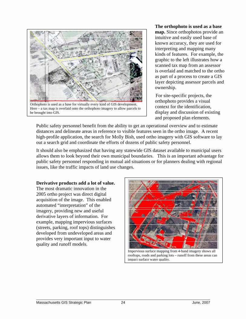
The orthophoto is used as a base map. Since orthophotos provide an intuitive and easily used base of known accuracy, they are used for interpreting and mapping many kinds of features. For example, the graphic to the left illustrates how a scanned tax map from an assessor is overlaid and matched to the ortho as part of a process to create a GIS layer depicting assessor parcels and ownership.
Orthophoto is used as a base for virtually every kind of GIS development. Here – a tax map is overlaid onto the orthophoto imagery to allow parcels to be brought into GIS.
For site-specific projects, the orthophoto provides a visual context for the identification, display and discussion of existing and proposed plan elements.
Public safety personnel benefit from the ability to get an operational overview and to estimate distances and delineate areas in reference to visible features seen in the ortho image. A recent high-profile application, the search for Molly Bish, used ortho imagery with GIS software to lay out a search grid and coordinate the efforts of dozens of public safety personnel.
It should also be emphasized that having any statewide GIS dataset available to municipal users allows them to look beyond their own municipal boundaries. This is an important advantage for public safety personnel responding in mutual aid situations or for planners dealing with regional issues, like the traffic impacts of land use changes.
Derivative products add a lot of value. The most dramatic innovation in the 2005 ortho project was direct digital acquisition of the image. This enabled automated “interpretation” of the imagery, providing new and useful derivative layers of information. For example, mapping impervious surfaces (streets, parking, roof tops) distinguishes developed from undeveloped areas and provides very important input to water quality and runoff models.
Impervious surface mapping from 4-band imagery shows all rooftops, roads and parking lots – runoff from these areas can impact surface water quality.
________________________________________________________________________ Massachusetts GIS Strategic Plan 24 June, 2007

Digital elevation data support the delineation of contributing areas for water resource studies – StreamStats from USGS / Water Resources Division web site
Digital elevation data is also significant. As a necessary part of creating orthophotography, the vendor created a “digital terrain model” (DTM). This data product represents the three-dimensional surface of the state in considerable detail. DTM’s are used for drainage studies, floodplain modeling, watershed analyses, habitat characterization, and for 3D visualization of the landscape in computerized “flyovers”. The currently available DTM supports applications for estimating stream flow and for viewshed analyses, most
notably the positioning of wind turbines. However, it is not detailed enough for many municipal applications.
2.2.2 Weaknesses - Current Needs Not Being Met There are four major problems with the current imagery/elevation mapping program. First, it is not institutionalized, in the sense of being regularly or reliably funded, so users are not able to plan for activities which depend on having current orthophotos. Since municipal fiscal planning cycles often require commitments and budget estimates more than a year in advance, the usefulness of orthophotos is severely limited.
Second, the current half-meter resolution does not meet all the needs of municipal users for a base that supports detailed identification and mapping of buildings and other infrastructure. While the half-meter resolution provides a good initial base to communities beginning to use GIS, 6” resolution (or better) is what most municipal users with enterprise GIS systems want. The absence of a dependable schedule and the limited resolution available from the state have forced dozens of communities to acquire more detailed imagery on their own.
Third, the digital terrain model currently available does not support many important applications. It is widely acknowledged that the spatial accuracy of most of the Flood Insurance Rate Maps (FIRM) published by the Federal Emergency Management Agency (FEMA) is poor. In many communities these maps have regulatory application, meaning that some property owners are unfairly restricted, and others are inadvisably allowed to build within the floodplain. With suitable terrain data it is possible to run engineering models to predict which areas will flood in a major rainfall event - a critical step to improving floodplain map quality.
This inability to model flood events has major impacts, not just on individual property owners, but also on entire communities downstream of dams and other flood control structures. FEMA has specified that a DTM for floodplain mapping must be equivalent to a topographic map with contour lines every two feet. In contrast, the current statewide terrain model provides only ten-foot contours.
A similarly-detailed digital terrain model for coastal areas, ideally including near-shore bathymetry (underwater elevations), is needed to track changes associated with sea-level rise and
________________________________________________________________________ Massachusetts GIS Strategic Plan 25 June, 2007
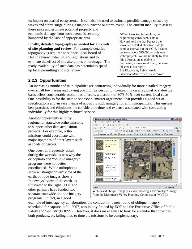
"When I worked in Franklin, our engineering consultant, Tata & Howard, told me that because the town had detailed elevation data (2' contour interval) in their GIS, it saved the town about $15,000 on only one water project. We are unlikely to have this information available in Fairhaven, a more rural town, because the cost is too high."
its impact on coastal ecosystems. It can also be used to estimate possible damage caused by waves and storm surge during a major hurricane or storm event. The current inability to assess these risks and estimate potential property and economic damage from such events is severely hampered by the lack of appropriate data.
Finally, detailed topography is needed for all kinds of site planning and review. For example detailed topography is required to support local Board of Health review under Title V regulations and to estimate the effect of site alterations on drainage. The ready availability of such data has potential to speed up local permitting and site review. Bill Fitzgerald, Public Works
Superintendent, Town of Fairhaven
2.2.3 Opportunities An increasing number of municipalities are contracting individually for more detailed imagery over small town areas and paying premium prices for it. Contracting on a regional or statewide basis offers considerable economies of scale, a discount of 30%-50% over current local costs. One possibility is for the state to sponsor a “master agreement” that provides a good set of specifications and an easy means of acquiring such imagery for all municipalities. This ensures best practices and eliminates the considerable time and expense associated with contracting individually for this highly technical service.
Another opportunity is to fly regional or statewide ortho missions to support other data acquisition projects. For example, ortho missions could coordinate with major upgrades of other layers such as roads or parcels.
One question frequently asked during the workshops was why the orthophoto and “oblique imagery” programs were not better coordinated. While orthophotos show a “straight down” view of the earth, oblique images show a “sideways” view of the earth, as illustrated to the right. EOT and other partners have funded two separate statewide oblique imagery programs. In fact, in a good example of inter-agency collaboration, the contract for a new round of oblique imagery scheduled for capture in fall 2007, was jointly funded by EOT and the Executive Office of Public Safety and Security (EOPSS). However, it does make sense to look for a vendor that provides both products, or, failing that, to time the missions to be complementary.
Web-based oblique imagery viewer showing a Pictometry™ image from the Merrimack Valley Planning Commission (MVPC)
________________________________________________________________________ Massachusetts GIS Strategic Plan 26 June, 2007
There has been some discussion at the Federal level of committing funding to a national imagery program based on a proposal called Imagery For the Nation (IFTN) developed by a consortium of agencies working with NSGIC. This represents a potentially significant opportunity to share costs, but it is uncertain whether or when this program will begin, and what funding may be available.
2.3 Streets and Linear Address Ranges
2.3.1 Strengths - Data Usefulness Background of the Massachusetts Road Inventory A digital street map of the Commonwealth has been developed and is being maintained “on top” of the orthophoto base. The Massachusetts Highway Department and the Executive Office of Transportation and Public Works (EOT) have long maintained an “asset based” inventory of the Commonwealth’s roads, including a set of physical attributes such as number of lanes, shoulder width and type, pavement width and type, sidewalk width and so on, to satisfy the reporting requirements of the Federal Highway Administration (FHWA). When road centerlines that matched visible features on the orthophoto base map were generated, EOT made that the base for their inventory system. And, because it is integrated with relatively accurate GIS data, the Massachusetts Road Inventory File is considered to be one of the more advanced statewide systems by the Federal government.
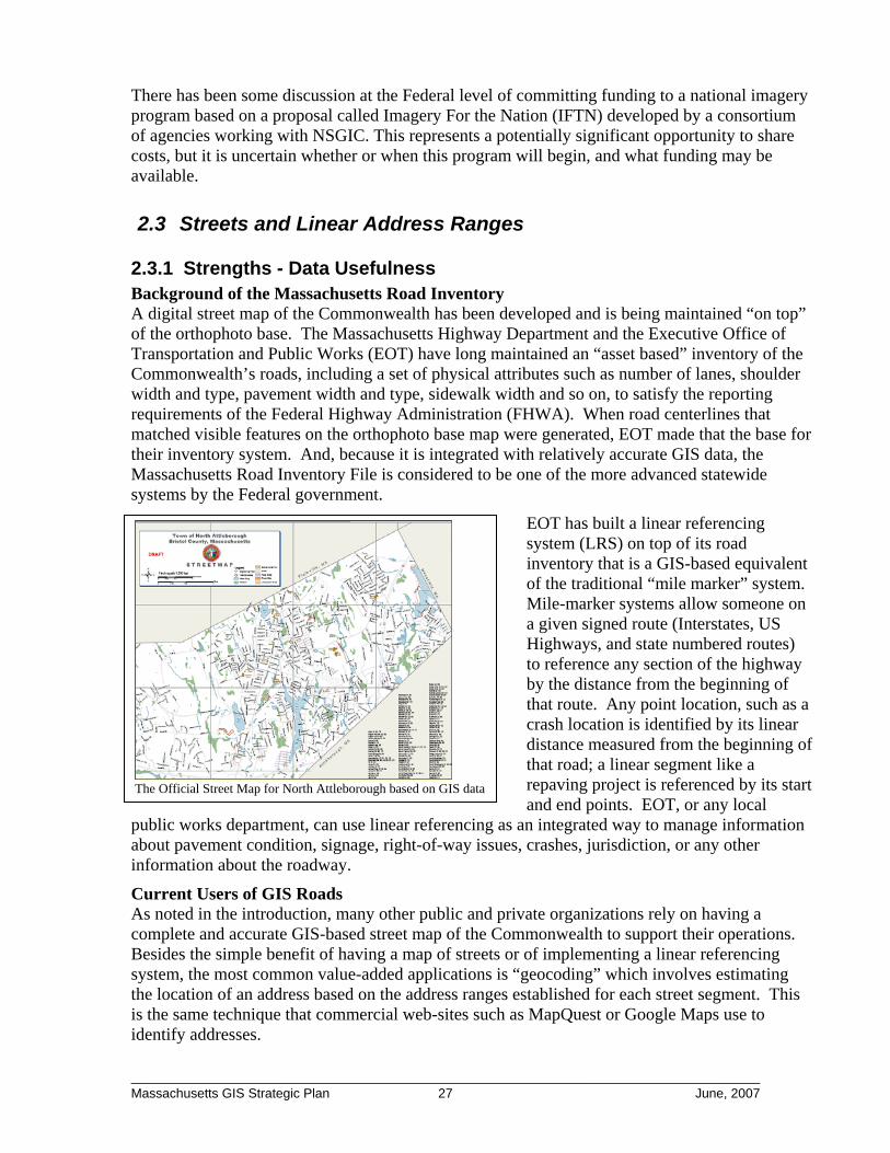
The Official Street Map for North Attleborough based on GIS data
EOT has built a linear referencing system (LRS) on top of its road inventory that is a GIS-based equivalent of the traditional “mile marker” system. Mile-marker systems allow someone on a given signed route (Interstates, US Highways, and state numbered routes) to reference any section of the highway by the distance from the beginning of that route. Any point location, such as a crash location is identified by its linear distance measured from the beginning of that road; a linear segment like a repaving project is referenced by its start and end points. EOT, or any local n integrated way to manage information
about pavement condition, signage, right-of-way issues, crashes, jurisdiction, or any other information about the roadway.
public works department, can use linear referencing as a
Current Users of GIS Roads As noted in the introduction, many other public and private organizations rely on having a complete and accurate GIS-based street map of the Commonwealth to support their operations. Besides the simple benefit of having a map of streets or of implementing a linear referencing system, the most common value-added applications is “geocoding” which involves estimating the location of an address based on the address ranges established for each street segment. This is the same technique that commercial web-sites such as MapQuest or Google Maps use to identify addresses.
________________________________________________________________________ Massachusetts GIS Strategic Plan 27 June, 2007

Current Road Maintenance
At present, many different organizations are working to maintain the road centerlines, and/or the associated address ranges for each block or street segment. At the state level, the alignment of the road centerlines was updated based on the EOT road inventory file and compiled on the 2001 orthophoto base map. It is currently being updated using the 2005 orthophotos.
The EOT Office of Transportation Planning (EOT-Planning) receives mapping updates and attributes about new roads directly from municipalities and uses that information to maintain the current ortho-based street layer. The total mileage of roads calculated for each community determines its allocation of Chapter 90 funding to support maintenance, like snow removal, and should be a strong incentive for communities to submit updates.
Illustration of different geocoding methods – in rural areas point estimates from linear geocoding can be hundreds of feet off their true location
Partnership with NAVTEQ
GoogleGoogle The data available in Google Maps and other on-line street maps are being maintained through a public-private partnership between Massachusetts and NAVTEQ
To complement the updates received from municipalities , OTP has also partnered with the Statewide Emergency Telecommunications Board (SETB, the program responsible for the 911 program) and with MassGIS to license a commercial street map database from NAVTEQ, a worldwide supplier of mapping for car navigation and Internet applications such as Google Maps. The added value of the NAVTEQ data is the address ranges which are assigned to every street segment. But since completeness and accuracy are paramount for the 911 system, SETB is also funding work at MassGIS to link the commercial maps from NAVTEQ to a statewide listing of streets and address ranges, called the Master Street Address Guide (MSAG), which is at the heart of the 911 system. MassGIS identifies where streets are missing from the EOT and commercial data; then
requests updates from NAVTEQ. Under this innovative arrangement, NAVTEQ:
1) Finds the missing streets in the field, with MassGIS providing guidance on location,
2) Maps the street using a GPS-enabled vehicle,
3) Verifies name and address range information.
In effect, NAVTEQ field checks every listing in the MSAG that does not already match the GIS mapping and provides a map update for it.
In an unusual aspect of this partnership, EOT and SETB licensed the NAVTEQ commercial data for use by all levels of government, state agencies, Regional Planning Agencies and cities and towns.
________________________________________________________________________ Massachusetts GIS Strategic Plan 28 June, 2007

This is an innovative and mutually beneficial public-private partnership:
• SETB gets updated roads and address ranges for use in the 911 system;
• EOT-Planning gets an updated accurate set of linework to add to the road inventory file;
• Other government users get free access to the data including geocoding capabilities;
• NAVTEQ improves their commercial product.
Thus, private sector users, including users of Google Maps and similar on-line mapping services, get a higher “hit rate” for their on-line geocoding requests. Finally, public users can download the updated linework from the MassGIS web-site (although the address ranges are not available, as they are only licensed to government users). Ultimately the public, whether accessing this mapping directly, or indirectly, benefits from its availability.
2.3.2 Weaknesses - Current Needs Not Being Met
2.3.2.1 Roads and Addresses Weaknesses While the partnership for maintaining GIS data on streets and addresses described above is innovative and cost-effective, it suffers by comparison to what neighboring states are currently doing; and in some respects, it falls far short of what is needed. There are three major problems with the current situation:
1. The linear style of geocoding does not provide the level of accuracy for locations that first responders and public safety officials say they need. Linear geocoding provides an estimate based on address ranges, but is frequently off by hundreds of feet. First responders prefer to use “point” style geocoding to locate an address exactly to the building footprint. In Vermont, New Hampshire, and Rhode Island, public safety programs have already funded similar point-level mapping of all addresses.
2. Naming new streets and assigning new address ranges is a municipal-level function and is not standardized statewide. A variety of town departments may be responsible for some or all of the steps involved: approving a new road right-of-way as part of a subdivision plan; receiving and filing an as-built layout; assigning address ranges to blocks and filling in the assignments of numbered addresses to individual lots and structures as they are built. In many towns, all these steps are based on paper plans and there may or may not be any GIS component. Even when a town has GIS capability, there may not be good communication between town departments about the approval of new streets or the assignment and physical location of new addresses. Frequently there is no single authoritative list of streets and addresses used by all town departments. Even major cities like Boston are currently struggling with this issue. Only a very few communities – notably Cambridge - have actually succeeded implementing an
enterprise-wide master address file with a standardized work flow to keep it current. “As soon as there is a foundation
permit on a building site, I need to know about it. There could be a structure fire, or a construction accident and we’d need to respond to that location.”
Lt. Dennis Bergeron Fitchburg Fire Department
3. Updates to street maps and address listings are not well integrated between the state and local levels of government. In theory, communities should be motivated to report new streets and street extensions to the EOT-Planning by the linkage to Chapter 90 funds. However, OTP reports that only 30% of communities file updates annually, whereas MassGIS estimates that over 80% should
________________________________________________________________________ Massachusetts GIS Strategic Plan 29 June, 2007

have something to report. Furthermore, submissions to EOT only cover “officially accepted” streets, and do not include private roads, so a significant portion of residential dwellings in some parts of the state are missing. From a 911 perspective, this is an obvious problem.
On the other hand, there is an explicit requirement for accurate and timely maintenance of the 911 Master Street Address Guide (MSAG). The MSAG is essentially a listing of all known addresses. Telephone service cannot be provided at a specific location unless the field address given for that installation conforms to the MSAG listing of streets and valid address ranges. But MSAG maintenance does not, at present, include any mapping of the address. Such mapping would determine an explicit latitude and longitude coordinate for each address. The current lack of built-in mapping for the MSAG results in an inefficient two-stage process whereby newly added streets in the MSAG are matched against NAVTEQ data and the locations of those streets collected after the fact - in some cases, many months, or even more than a year later.
While not related to emergency response, the Decennial Federal Census creates another critical need for comprehensive address information by community. Starting with the 2000 census, the Census Bureau implemented a new program called the Local Update of Census Addresses (LUCA), which requires municipal government to verify the Census Bureau’s address records for each community. These verified addresses are then used by Census enumerators as they conduct the census. Most municipalities do not have a comprehensive list of their valid addresses and are not fully prepared to do comprehensive validation. Such validation gaps raise the possibility of the Census missing some new development and could lead to undercounting. The stakes are high as population projections show that Massachusetts could lose a seat in the House of Representatives as a result of the 2010 Census. Therefore, it is essential that communities are able to comprehensively and correctly validate and update the Census Bureau’s address records.
2.3.2.2 Road Asset Inventory Weaknesses The stakeholder community identified several areas besides addressing where the road inventory data could be improved. These include:
1. Integrating special traffic count data: MassHighway collects traffic counts at the same 2,000 locations over a three-year period that is included in the road inventory file. RPAs and MassHighway also collect special one-time traffic count information that could be, but is not presently, integrated with the road inventory information. If this additional traffic count data were readily available via the road inventory a great deal of value would be added for state and local officials engaged in highway safety review, traffic planning and project review.
2. Providing a model for local attribute integration: Many communities have their own street centerlines that differ from the EOT inventory mainly by the attributes that are stored. More communities could use the EOT road inventory as a baseline if they could easily attach their own attributes (e.g. one-way streets, speed limits, etc.) to the EOT geometry.
3. Managing complex roadway geometry: Managing a roadway network can be geometrically complex. Situations such as divided highways, traffic islands, bridges, tunnels and highway interchanges provide many challenges and options for geometric representation. Clear standards and guidance for handling these types of situations would
________________________________________________________________________ Massachusetts GIS Strategic Plan 30 June, 2007
help position communities and the state to more effectively share the GIS-based road inventories.
2.3.3 Opportunities
2.3.3.1 Addressing Opportunities For each problem listed in Section 2.3.2.1, a variety of opportunities exist to improve the current situation. First, many stakeholders recognize the poor accuracy of linear geocoding and are seeking better solutions. As discussed later, there is a significant opportunity to take advantage of the address information linked to parcel maps to improve the accuracy of geocoding and move from linear to point style geocoding. A very diverse constituency supports such an evolution. For example, utilities might partner with towns and the state to maintain geographic point locations based on their customer address listings.
Second, there is an opportunity to improve municipal participation in maintaining transportation data by developing standards to compile data, giving technical assistance to comply with those standards, and creating incentives and requirements to share data. Where currently there are redundant efforts and lack of communication, technical assistance could be delivered from a state or regional level to improve procedures and disseminate methods that work well through peer-networking and other means. In turn, this would engage local governments in the cooperative maintenance of the Commonwealth’s road map. Such collaboration will benefit both the state and localities.
Third, it is possible to use Internet-based applications to integrate maintenance of street listings and master address files with the maintenance of geographic data. The state should commit to increased Internet access for municipal users to support the kind of engagement discussed above. Web-based updating and editing of address points is technically feasible – what’s missing is the municipal network access and staff support.
Finally, EOT should share GIS data and the associated technical capabilities of the Linear Referencing System with municipal public works departments. This will improve data sharing on road-related projects, such as road widening or repaving, that are located on adjacent jurisdictions and are of mutual concern. Again, providing incentives for municipalities to use and maintain EOT data will quickly pay for itself in improved data quality.
2.3.3.2 Road Asset Inventory Opportunities As with addresses, there are a variety of opportunities to deal with the weaknesses identified in Section 2.3.2.2. The core opportunity is for MassGIS and EOT to work together to establish a road inventory data standard that both articulates the Commonwealth’s preferred data structures and provides guidance to communities that wish to build on this base, or to develop their own data sets – both graphic and tabular - that are compatible to the greatest extent possible.
2.3.4 Threats The workflows that maintain streets and addresses are spread among a number of municipal entities and utilities, creating serious obstacles to leveraging or standardizing efforts. First, incentives for standardization are not in place. Second, there are concerns about sharing proprietary information. Third, and most importantly, there are no agreed-upon mechanisms to
________________________________________________________________________ Massachusetts GIS Strategic Plan 31 June, 2007

resolve disagreements. This is the biggest threat to building a single, current and seamless street centerline and to improving geocoding. Ultimately, many key players will prefer their own data to trusting anyone else’s. Even within a single city, there can be a proliferation of street lists and address files at the department level.
2.4 Parcel Mapping Each community in Massachusetts is required by the Department of Revenue to maintain a complete map of property parcels as part of the property tax assessment process. Historically, these hard-copy maps have been maintained on Mylar or linen at scales ranging from 1” = 40’ to 1” = 200’. These maps show the approximate boundaries of each property parcel along with related information (e.g., parcel ID, area, street names) to assist with property valuation. Over the past 15 years there has been an increasing trend for communities to manage their property parcel maps using GIS technology and the resultant digital parcel data are among the most important and versatile of any GIS data set.
2.4.1 Strengths - Data Usefulness As a foundation, parcel data are invaluable to GIS activities in town departments including Schools, Conservation / Recreation, Health, Planning and Zoning, Public Works, Police, Fire, Clerk’s Office, Building / Inspections and of course, Assessors. In addition, at the state level parcel data are invaluable to wide variety of environmental, transportation, public health and public safety programs
Converting Massachusetts’ parcel maps to electronic form for use in GIS is a fairly recent development. The first Massachusetts communities taking this step did so in the early 1990s. By late 2006, the parcel maps in about 200 communities were in some sort of electronic form (shades of blue in graphic at left; approximately 60% of all parcels) with quality ranging from poor to excellent. About fifty communities have files that comply with Level II of the MassGIS Standard for Digital Parcel Files (darkest blue in graphic; approximately 20% of all parcels).
The MassGIS standard5 is widely viewed as a substantial improvement over having a haphazard variety of data management schemes in use. Initially released in 2001, subsequent revisions were modest. The standard is mature and well tested. The essential elements of the original standard remained the same and aim to:
1. Provide communities a flexible specification for developing a digital parcel file for use in a GIS database
2. Make it possible to merge parcel data from multiple communities for multi-town mapping and analysis.
5 Full details on the standard are beyond the scope of this document; the standard can be found at www.mas.gov/mgis/standards.htm#Parstandard.
________________________________________________________________________ Massachusetts GIS Strategic Plan 32 June, 2007

3. Establish parcel ID that is unique statewide.
4. Assure a minimum level of spatial accuracy.
5. Assure a minimum and consistent set of descriptive items from the assessor’s database are associated with each parcel on the map.
6. Assure that each entry in the assessor database is associated with a parcel on the map.
Most of these requirements are not really burdensome; however, the requirement for spatial accuracy goes well beyond the minimal requirements for parcel mapping issued by the DOR. Interestingly, since the standard was issued, an increasing number of communities have willingly assumed this added cost. Parcel data currently support many applications, particularly at the local level. The graphic at right from Hull, illustrates using neighborhood characteristics, like an ocean view, to assign assessed values to residential properties. This type of GIS mapping makes valuation more transparent and defensible, which leads to fewer requests for abatements.
In communities where digital parcel data are available, there is strong consensus that having the information readily available to the public, particularly to developers and project proponents, is a benefit. Projects where there are serious natural resource constraints can be identified early in the process and business decisions can be made accordingly. In the graphic to the left, wetland areas, as mapped by DEP, are shown on top of the Norton town parcel maps. In this way, developers and regulators are “on the same page” looking at potential projects.
Wetlands (pale green shading) shown on top of parcels for Town of Norton
________________________________________________________________________ Massachusetts GIS Strategic Plan 33 June, 2007
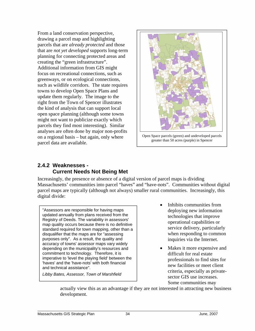
From a land conservation perspective, drawing a parcel map and highlighting parcels that are already protected and those that are not yet developed supports long-term planning for connecting protected areas and creating the “green infrastructure”. Additional information from GIS might focus on recreational connections, such as greenways, or on ecological connections, such as wildlife corridors. The state requires towns to develop Open Space Plans and update them regularly. The image to the right from the Town of Spencer illustrates the kind of analysis that can support local open space planning (although some towns might not want to publicize exactly which parcels they find most interesting). Similar analyses are often done by major non-profits on a regional basis – but again, only where parcel data are available.
Open Space parcels (green) and undeveloped parcels greater than 50 acres (purple) in Spencer
2.4.2 Weaknesses - Current Needs Not Being Met
Increasingly, the presence or absence of a digital version of parcel maps is dividing Massachusetts’ communities into parcel “haves” and “have-nots”. Communities without digital parcel maps are typically (although not always) smaller rural communities. Increasingly, this digital divide:
• Inhibits communities from deploying new information technologies that improve operational capabilities or service delivery, particularly when responding to common inquiries via the Internet.
• Makes it more expensive and difficult for real estate professionals to find sites for new facilities or meet client criteria, especially as private-sector GIS use increases. Some communities may
actually view this as an advantage if they are not interested in attracting new business development.
"Assessors are responsible for having maps updated annually from plans received from the Registry of Deeds. The variability in assessors' map quality occurs because there is no definitive standard required for town mapping, other than a disqualifier that the maps are for "assessing purposes only". As a result, the quality and accuracy of towns' assessor maps vary widely depending on the municipality’s resources and commitment to technology. Therefore, it is imperative to 'level the playing field' between the 'haves' and the 'have-nots' with both financial and technical assistance". Libby Bates, Assessor, Town of Marshfield
________________________________________________________________________ Massachusetts GIS Strategic Plan 34 June, 2007
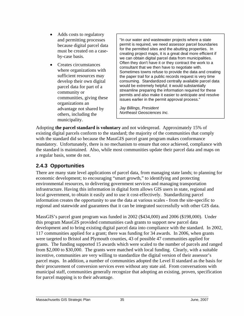
• Adds costs to regulatory and permitting processes because digital parcel data must be created on a case-by-case basis.
“In our water and wastewater projects where a state permit is required, we need assessor parcel boundaries for the permitted sites and the abutting properties. In creating project maps, it is a great deal more efficient if we can obtain digital parcel data from municipalities. Often they don't have it or they contract the work to a consultant that we then have to negotiate with. Sometimes towns refuse to provide the data and creating the paper trail for a public records request is very time consuming. Standardized centrally available parcel data would be extremely helpful; it would substantially streamline preparing the information required for these permits and also make it easier to anticipate and resolve issues earlier in the permit approval process."
Jay Billings, President Northeast Geosciences Inc.
• Creates circumstances where organizations with sufficient resources may develop their own digital parcel data for part of a community or communities, giving these organizations an advantage not shared by others, including the municipality.
Adopting the parcel standard is voluntary and not widespread. Approximately 15% of existing digital parcels conform to the standard; the majority of the communities that comply with the standard did so because the MassGIS parcel grant program makes conformance mandatory. Unfortunately, there is no mechanism to ensure that once achieved, compliance with the standard is maintained. Also, while most communities update their parcel data and maps on a regular basis, some do not.
2.4.3 Opportunities There are many state level applications of parcel data, from managing state lands; to planning for economic development; to encouraging “smart growth,” to identifying and protecting environmental resources, to delivering government services and managing transportation infrastructure. Having this information in digital form allows GIS users in state, regional and local government, to obtain it easily and to use it cost-effectively. Standardizing parcel information creates the opportunity to use the data at various scales - from the site-specific to regional and statewide and guarantees that it can be integrated successfully with other GIS data. MassGIS’s parcel grant program was funded in 2002 ($434,000) and 2006 ($198,000). Under this program MassGIS provided communities cash grants to support new parcel data development and to bring existing digital parcel data into compliance with the standard. In 2002, 117 communities applied for a grant; there was funding for 34 awards. In 2006, when grants were targeted to Bristol and Plymouth counties, 43 of possible 47 communities applied for grants. The funding supported 15 awards which were scaled to the number of parcels and ranged from $2,000 to $30,000. The grants were matched with local funding. Clearly, with a suitable incentive, communities are very willing to standardize the digital version of their assessor’s parcel maps. In addition, a number of communities adopted the Level II standard as the basis for their procurement of conversion services even without any state aid. From conversations with municipal staff, communities generally recognize that adopting an existing, proven, specification for parcel mapping is to their advantage.
________________________________________________________________________ Massachusetts GIS Strategic Plan 35 June, 2007
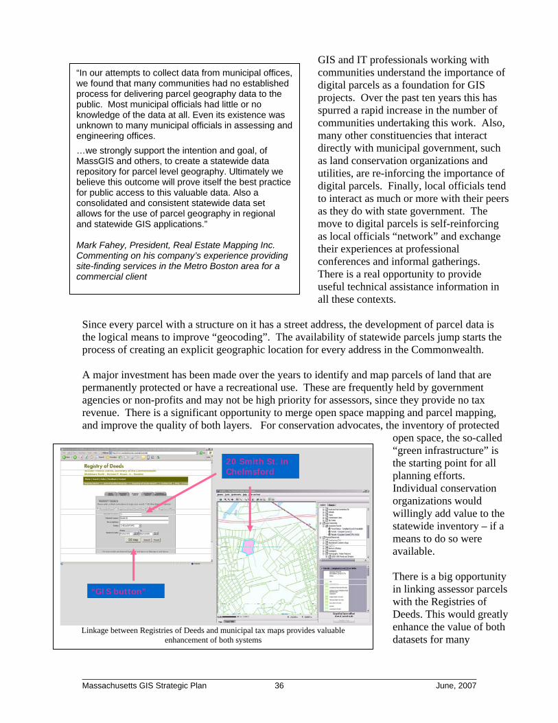
GIS and IT professionals working with communities understand the importance of digital parcels as a foundation for GIS projects. Over the past ten years this has spurred a rapid increase in the number of communities undertaking this work. Also, many other constituencies that interact directly with municipal government, such as land conservation organizations and utilities, are re-inforcing the importance of digital parcels. Finally, local officials tend to interact as much or more with their peers as they do with state government. The move to digital parcels is self-reinforcing as local officials “network” and exchange their experiences at professional conferences and informal gatherings. There is a real opportunity to provide useful technical assistance information in all these contexts.
“In our attempts to collect data from municipal offices, we found that many communities had no established process for delivering parcel geography data to the public. Most municipal officials had little or no knowledge of the data at all. Even its existence was unknown to many municipal officials in assessing and engineering offices.
…we strongly support the intention and goal, of MassGIS and others, to create a statewide data repository for parcel level geography. Ultimately we believe this outcome will prove itself the best practice for public access to this valuable data. Also a consolidated and consistent statewide data set allows for the use of parcel geography in regional and statewide GIS applications.” Mark Fahey, President, Real Estate Mapping Inc. Commenting on his company’s experience providing site-finding services in the Metro Boston area for a commercial client
Since every parcel with a structure on it has a street address, the development of parcel data is the logical means to improve “geocoding”. The availability of statewide parcels jump starts the process of creating an explicit geographic location for every address in the Commonwealth.
20 Smith St. in Chelmsford
“GIS button”
20 Smith St. in Chelmsford
“GIS button”
A major investment has been made over the years to identify and map parcels of land that are permanently protected or have a recreational use. These are frequently held by government agencies or non-profits and may not be high priority for assessors, since they provide no tax revenue. There is a significant opportunity to merge open space mapping and parcel mapping, and improve the quality of both layers. For conservation advocates, the inventory of protected
open space, the so-called “green infrastructure” is the starting point for all planning efforts. Individual conservation organizations would willingly add value to the statewide inventory – if a means to do so were available. There is a big opportunity in linking assessor parcels with the Registries of Deeds. This would greatly enhance the value of both datasets for many
Linkage between Registries of Deeds and municipal tax maps provides valuable enhancement of both systems
________________________________________________________________________ Massachusetts GIS Strategic Plan 36 June, 2007

stakeholders – from the assessors themselves, to conservation groups, to real estate developers, to all the paralegal staff involved with researching and reconciling land records. The image above represents a prototype system envisioned by MassGIS and the Middlesex North Registry of Deeds.
2.4.4 Threats and Challenges Outside New England, county government is responsible for assessor parcel mapping, which simplifies standardization because there are fewer units of government. In addition, a county has more property parcels, creating economies of scale that reduce map conversion costs and make parcel maintenance in a digital environment more attractive. In contrast, with 351 cities and towns, parcel map conversion and standardization in Massachusetts is administratively more complex and more expensive when performed one community at a time. Many small communities have absolutely minimal capacity to integrate technology into their operations, creating a tendency to stick with the “tried-and-true” way of doing things and to resist change. Any attempt by the state to mandate substantial change, without appropriate compensation, would elicit strong resistance as an “unfunded mandate.” On the other hand, communities have little incentive to adopt the statewide standard if they already have a digital parcel map that meets their needs. If a community has its own GIS staff, the time required for them to learn the standard and fix problems with their data becomes a barrier. Given typical municipal budget constraints, paying a consultant to make their digital parcels comply with the standard is usually not an attractive alternative. Standardization facilitates access to parcel data over larger geographic areas and reduces the cost of parcel-oriented application development. But no process exists through which communities can routinely provide up-to-date parcel maps for a state or regional agency to aggregate into a larger area parcel map. As noted above, the link between parcel and registry data presents a tremendous opportunity, but there are significant institutional and political barriers. Neither group sees it as within their existing mandate to create and maintain such a linkage and neither feels they have the resources or capacity to do so. Assessor maps and related descriptive information collected for assessment purposes are public records6 and must be provided to any requestor. This is true whether those records are in paper or electronic form. Of course, once in digital form, assessor maps and data are much easier to copy and distribute. This has led some communities to restrict distribution of maps and data due to concerns about personal privacy. These restrictions are usually in the form of a “license agreement” or a “memorandum of understanding” that communities require be signed as a pre-condition to obtaining copies of the digital parcel map and data records. These agreements are typically not permissible under the public records law7. The public records law also instructs that the fee for providing copies should be based on the hourly rate of the lowest paid employee capable of making the copy and does not permit cost 6 Some of the public records law exemptions do apply to a small minority of assessor property records. 7 There is no known case of these restrictions being legally tested in Massachusetts.
________________________________________________________________________ Massachusetts GIS Strategic Plan 37 June, 2007

recovery of the original cost of the mapping or the GIS conversion. However, a small number of communities charge fees for copies of their digital assessor maps and GIS data that appear to far exceed any plausible cost of the staff time to make the copy. Finally, most assessor maps state that the information they present must not be used to support any legal determination of boundaries related to rights or interests in real property. In other words, their maps depict approximate boundaries of land ownership. However, as these maps are converted to digital form, there is a legitimate concern among land surveyors that users of assessor parcel maps will mistakenly assume that these maps show actual boundary locations, and not read the “fine print” of disclaimers. By law, determining boundary locations in a legal context requires a professional land surveyor8. It is essential that municipal staff educate users of their digital parcel files so it is clear that maps created with these files are used for assessing, planning, and general site-review purposes only. This distinction must be communicated whether the maps are shown on a computer or in printed form.
2.5 Critical Infrastructure For the purposes of this project, critical infrastructure data refers to facilities and locations that, based on a street address, can be associated with a property parcel or a building. Facility locations include such features as police and fire stations, electrical generation plants, and hospitals. Of particular concern are the locations of sensitive populations such as nursing homes and rehabilitation facilities, schools, and day care centers.
2.5.1 Strengths - Data Usefulness After the terrorist attacks of September 2001 and recent blizzards, floods and hurricanes, there is widespread agreement in the emergency management community that effective planning, mitigation and response to disasters and other kinds of incidents require readily available high quality information on the locations of vulnerable populations and key facilities. This understanding has resulted in significant effort being expended in Massachusetts and elsewhere to develop GIS-based critical infrastructure data and supporting data such as oblique imagery. This data development effort has been accompanied by other initiatives to develop data standards, to implement data maintenance procedures, to make data readily available to emergency managers, and to share data among different levels of government. In fact, there has been considerable progress toward the goal of effectively providing reliable critical infrastructure mapping data to emergency managers. One example of statewide critical infrastructure data collection is the Massachusetts Emergency Management Agency’s (MEMA) eCEMP application (electronic Comprehensive Emergency Management Plan). This application (illustrated below) represents the evolution from a historical paper-based process of emergency planning to one that is on-line with secure data input, including GIS information, via a web browser. Applications such as eCEMP exemplify collaborative critical infrastructure data development. Data that are originally collected and stored within eCEMP can be readily shared with a variety of other public safety applications such as ACAMS, the current standard for the Commonwealth’s Fusion Center, to support parallel homeland security or disaster recovery missions.
8 The reason that the Commonwealth requires surveyors to be licensed is, in part, to “…safeguard life, health, and property [and] to promote the public welfare”. (250 CMR 4.00)
________________________________________________________________________ Massachusetts GIS Strategic Plan 38 June, 2007
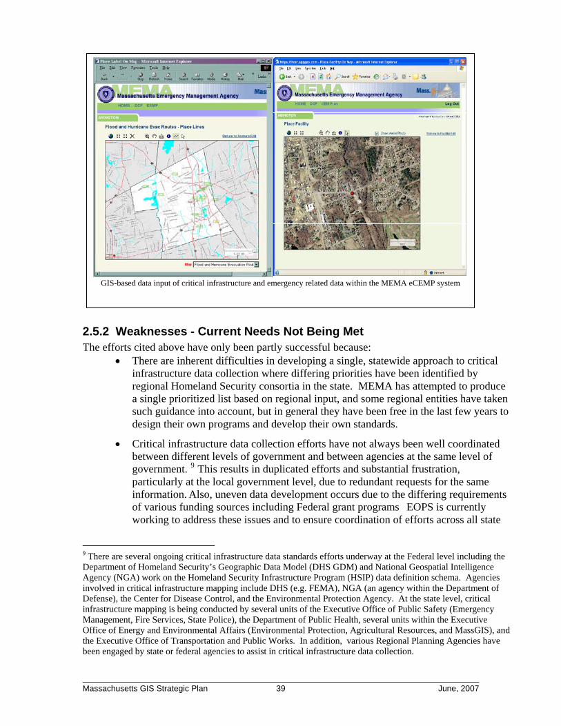
GIS-based data input of critical infrastructure and emergency related data within the MEMA eCEMP system
2.5.2 Weaknesses - Current Needs Not Being Met The efforts cited above have only been partly successful because:
• There are inherent difficulties in developing a single, statewide approach to critical infrastructure data collection where differing priorities have been identified by regional Homeland Security consortia in the state. MEMA has attempted to produce a single prioritized list based on regional input, and some regional entities have taken such guidance into account, but in general they have been free in the last few years to design their own programs and develop their own standards.
• Critical infrastructure data collection efforts have not always been well coordinated between different levels of government and between agencies at the same level of government. 9 This results in duplicated efforts and substantial frustration, particularly at the local government level, due to redundant requests for the same information. Also, uneven data development occurs due to the differing requirements of various funding sources including Federal grant programs EOPS is currently working to address these issues and to ensure coordination of efforts across all state
9 There are several ongoing critical infrastructure data standards efforts underway at the Federal level including the Department of Homeland Security’s Geographic Data Model (DHS GDM) and National Geospatial Intelligence Agency (NGA) work on the Homeland Security Infrastructure Program (HSIP) data definition schema. Agencies involved in critical infrastructure mapping include DHS (e.g. FEMA), NGA (an agency within the Department of Defense), the Center for Disease Control, and the Environmental Protection Agency. At the state level, critical infrastructure mapping is being conducted by several units of the Executive Office of Public Safety (Emergency Management, Fire Services, State Police), the Department of Public Health, several units within the Executive Office of Energy and Environmental Affairs (Environmental Protection, Agricultural Resources, and MassGIS), and the Executive Office of Transportation and Public Works. In addition, various Regional Planning Agencies have been engaged by state or federal agencies to assist in critical infrastructure data collection.
________________________________________________________________________ Massachusetts GIS Strategic Plan 39 June, 2007
agencies.
• Currently, GIS resources within public safety agencies (e.g. MEMA) are not adequate for those agencies to fully support management of the hundreds of data layers identified as relevant. Stewardship of critical infrastructure data involves direct, hands-on data development, quality assurance and maintenance as well as ongoing coordination with federal and local collaborators. The same GIS staff responsible for data are also being tasked with planning and analysis and with developing applications for data access. At current staffing levels, they can not meet these multiple responsibilities.
• Some participants in the strategic plan interviews noted that with the need to focus on emergency planning and response and other public safety missions; it is difficult for public safety agencies to maintain the depth of specialized expertise needed for GIS database administration or in-house application development in support of editing and quality assurance. There may be some opportunities to exploit synergies with similar needs at MassGIS.
• While mapping critical infrastructure and pursuing robust data maintenance and access procedures for the data have been recognized as important goals, as indicated above, previous to the current administration there has not been a strong coordinating role at the Secretariat level with a clear goal to implement solutions that apply across multiple agencies.
2.5.3 Opportunities Problems mapping critical infrastructure and implementing robust data maintenance and access procedures have been recognized and are part of an ongoing discussion. Reasons for optimism include:
• Informal staff-level communications, particularly among state agency staff, are leading to some coordinated data development and the elimination of some redundant effort. These may provide the foundation for sorely needed management-level coordination. One significant area for collaboration should be to respond to the near universal expression by public safety personnel of the need for a complete and accurate geocoding base.
• Federal resources, particularly financial resources, are available. Criteria used to allocate Federal funds increasingly recognize the importance of spatial data infrastructure and include requirements to demonstrate a coordinated approach.
• Applications such as MEMA’s eCEMP application provide a vehicle for on-line input and validation of critical infrastructure data sets from the local level, taking full advantage of local knowledge and web-based technology.
[NOTE: After the completion of this report, but before its release, the Executive Office of Public Safety and Security (EOPSS) released its State Homeland Security Strategy. One objective listed in that report was to “Enhance Geographic Information System Capabilities”; this objective was explained as follows:
________________________________________________________________________ Massachusetts GIS Strategic Plan 40 June, 2007

“In support of the all-hazards approach to homeland security and other efforts, the state needs the capacity to quickly and accurately visualize patterns of activity, map locations, model potential hazards, and put emergency situations into a geospatial context. In the event of a major hurricane, GIS would be essential in identifying emergency traffic routes, locating areas likely to suffer the greatest impact, identifying critical infrastructure in impacted areas, and organizing and prioritizing recovery efforts. GIS has proven to be an effective and efficient tool in supporting all of these homeland security and public safety efforts. GIS has also proven invaluable in planning efforts and resource allocation in support of transportation planning, public safety efforts, environmental assessments, and other uses by all agencies of the Commonwealth.” The EOPSS strategy proposed implementing this objective as follows: “Adopt and share GIS capabilities: This year, EOPSS and the Executive Office of Transportation and Public Works coordinated and collaborated on obtaining updated statewide digital imagery to support GIS across the Commonwealth. That imagery will be maintained on a secure database to ensure that all files are available to relevant state and municipal employees. In addition, to more cohesively reflect the GIS needs of the homeland security and public safety community, EOPSS has established a GIS working group to develop and implement a coordinated approach toward MASS GIS strategic objectives.”]
2.5.4 Threats Overall, the discussion about requirements, costs, options and responsibilities for GIS data development related to public safety needs to be more inclusive. There have been many individual geospatial initiatives within EOPS, but in previous administrations there has not been strong strategic direction of these data collection efforts at the secretariat level. This has hindered both internal progress and collaboration with other GIS stakeholders and programs. The current administration has recognized this need and is working to develop a coordinated and rational approach. While the public has a fundamental right to request information from all levels of state government, there also need to be provisions for dealing with statutory exemptions to the public records law which limit access to sensitive data and for recognizing legitimate privacy and security concerns. However, it would be unfortunate if concerns of this nature inhibited the sharing of data sets used by public safety agencies that are not really sensitive. As such, there needs to be a focused, interagency effort to look at critical infrastructure data sensitivity and to clearly designate those data that are subject to limitations on use and distribution. To the extent possible, geospatial data security issues should be aligned with other governmental efforts aimed at identifying and protecting sensitive data such as the Executive Office of Administration and Finance, Information Technology Division’s (EOAF ITD) efforts to articulate a data security classification policy.
________________________________________________________________________ Massachusetts GIS Strategic Plan 41 June, 2007

3 Vision, Goals and Recommendations Massachusetts can capitalize on the considerable strengths of its GIS efforts and address the deficiencies described above through careful planning, adoption of new policies, targeted investment, and attention to workflow design and procedures in government. The key goal is to begin managing the Commonwealth’s GIS assets and programs as a cohesive GIS infrastructure. The vision and recommendations presented below define and detail the benefits of this approach.
3.1 Vision for a Massachusetts Spatial Data Infrastructure Infrastructure is defined as “the fundamental facilities and systems that serve an area”10. Throughout this report, the concept of “physical infrastructure” is extended so that the core systems providing GIS capabilities to the government and general public are considered as “spatial data infrastructure.” GIS in Massachusetts has not been developed or managed as infrastructure. Rather, it has grown organically and opportunistically, as a series of projects. However, as GIS use continues to grow (see web statistics to the right), more and more government programs rely on it for mission-critical functions. It is clear that it must be recognized as part of the overall information technology infrastructure of the Commonwealth and be managed as such.
Data down loaded from MassGIS via FTP 4-year increase of 135%:
2004 2005 2006 2007* 1.93TB 2.68TB 3.35TB 4.55TB
Launches of on-line “OLIVER” data viewer 3-year increase of 51%:
2005 2006 2007* 42,741 52,278 64,605
Web map images generated 4-year increase of 50%:
2004 2005 2006 2007* 3.8M 4.9M 4.8M 5.7M
* Based on extrapolation of first 4 months of data
Existing geographic information systems provide ready access to high quality data sets and software capabilities that support a very broad range of government and business activity from property tax assessment to retail store location to emergency response to land protection to sewer system management and so on. Due to the multi-purpose nature of GIS data, the recurring theme in this vision for the future is that the Commonwealth’s geospatial data should be developed and maintained as a shared resource. This can be done by:
• Assigning formal responsibility for the GIS infrastructure to keep it on-line and in good working order
• Keeping the infrastructure well maintained by centrally funding regular updates for key data sets
10 From www.Dictionary.com a multi-source dictionary search service provided by Lexico Publishing Group, LLC.
________________________________________________________________________ Massachusetts GIS Strategic Plan 42 June, 2007

• Periodically reinvesting in the infrastructure to fill identified data gaps and to provide improved capacity and service
• Empowering local participation by recognizing and leveraging the synergies of data sharing
The Commonwealth recognizes the broad economic benefits of investments made in transportation infrastructure such as roads, bridges and airports. There is increasing recognition that investments in information technology (IT) infrastructure – high-speed networks, e-government – are important elements of the 21st century economy. Massachusetts made a substantial down payment by creating the “foundation” of the GIS elements of the Commonwealth’s IT infrastructure. Now is the time to finish “building” and take ownership. Having such a rich GIS/IT infrastructure over the next decade will be increasingly critical to help the Commonwealth meet real and pressing development, environmental protection, and public safety challenges. Consider the following public safety and planning scenarios. Much of what is outlined below can be done with existing GIS technology. However, as of early 2007, key components of both scenarios will require that gaps in the GIS infrastructure be filled. Major Hurricane Forecast to Hit Southeastern Massachusetts • GIS-based disaster pre-planning has
identified low-lying areas susceptible to storm surge.
• Pre-planning has also identified the shelter locations to open in a mass emergency.
• Statewide parcel data overlain with flood prone areas could be used to identify vulnerable residents and businesses.
• Parcel and related address-point data are also used to identify sensitive populations - such as day care centers, nursing homes, group homes – in the flood prone areas.
• As the event unfolds and evacuation decisions are made, emergency planners access detailed maps highlighting the most vulnerable areas. This enables them to account for total population affected in relation to the shelter locations and capacity available.
• As evacuation orders are given, first responders are provided high quality maps and electronic displays that help prioritize how field assets are deployed and where bottlenecks might be.
• On-line maps and notices posted to the internet in real-time help evacuees identify recommended evacuation routes and find shelters that can receive them.
• During and after the event, damage and casualties are identified and mapped to help drive response and post-event damage assessment which will help support the next round of planning.
________________________________________________________________________ Massachusetts GIS Strategic Plan 43 June, 2007

With a statewide GIS infrastructure in place, rich, accurate and current data could be available in every community from Fall River to Falmouth to support a coordinated and well-executed response. The Commonwealth Explores the Redevelopment of an Urban Property
• The Division of Capital and Asset Management (DCAM) considers the sale of a 50-acre parcel, a former mill site.
• Statewide parcel data allows DCAM to immediately access detailed information on the valuation of parcels in the area.
• Using the statewide orthophotos, DCAM is able to look at site-level details such as buildings and other structural features, paved areas, and surrounding neighborhood characteristics.
Environmental and tax data mapped in support of brownfields redevelopment, City of Worcester, GIS Department
• DCAM can view soil suitability, groundwater contours, and topography as well as the extent of any wetlands on the site.
• The statewide GIS repository also contains information on local zoning and links to the actual zoning by-law so that DCAM can determine whether development might require zoning changes that could lengthen the development cycle and reduce the desirability of the property.
• DCAM examines GIS data from the Department of Environmental Protection (DEP) that show locations of regulated entities, such as solid waste or chemical storage facilities. Reports from the investigation of potential hazardous material releases (21e sites) are on-line and can be linked to point locations using GIS.
• Finally, using GIS, DCAM can view census data on population, income and ethnicity of the area around the site – and the designation of neighboring blocks as environmental justice areas.
By having ready-access to the diverse array of data that impacts development potential, DCAM planners can efficiently assess opportunities and determine how best to manage the Commonwealth’s assets, while supporting other policy goals such as brownfield redevelopment and urban revitalization.
3.2 Recommendations to Advance the Development of a Massachusetts Spatial Data Infrastructure
The following package of seven recommendations will substantively move the Commonwealth towards realizing the goals of a functioning Massachusetts Spatial Data Infrastructure (MSDI). Some recommendations require policy prioritization and further evolution of existing
________________________________________________________________________ Massachusetts GIS Strategic Plan 44 June, 2007
programs. Others require new capital investments. If these recommendations are carried out, the Massachusetts geospatial landscape will be strengthened by gaining:
• Stronger data sets that are regularly and systematically updated
• Technical infrastructure that facilitates the smooth sharing of data between: o State agencies o Local and state government o Federal agencies and the state
• Organizational and technical support for MassGIS to evolve and continue to build the relationships necessary to maintain a Massachusetts Spatial Data Infrastructure
3.2.1 Recommendation #1: Regularize the statewide digital orthophoto program to provide a 3-year update cycle
The current statewide orthophoto program has provided three sets of statewide imagery from 1994-1997, 2001 and 2005. While the data have been updated periodically, it required strenuous efforts and an opportunistic approach to funding, with no clear plan each time for how the next update would be done. These data are widely used by all stakeholder groups on a daily basis and many expressed the need for regular, reliable updates of this core data set. Stakeholders also expressed a strong desire to improve the pixel resolution from the current ½ meters (i.e. approximately 18 inches) to 6-9 inches which is better for many municipal applications. In addition to being unsustainable, the current funding model creates a “free rider” problem whereby some major users of the data do not contribute, regardless of their ability to pay. The overall recommendation is simple - the Commonwealth should have a program in place to produce statewide digital orthophoto images every three years. Further recommendations on program details:
• The flight should capture digital 4-band imagery and stereo frames on a statewide basis.
• At a minimum, the baseline specification for statewide imagery should match the three previous orthophoto projects:
o Scale: 1”:5,000” or approximately 1” = 400’ o Resolution: ½ meters
But it is strongly recommended that the Commonwealth should seek both project and technological opportunities to cost effectively improve this baseline. For example, a project to digitize parcels (Recommendation #3 below) would provide a strong rationale for orthophotos at a resolution of 6-9 inches.
• In addition to digital orthophotos, the program should continue to produce derivative products of impervious surface and land use classification such as were developed as part of the 2005 project.
• The state should consider flying half of the state in each of two successive years. Due to the volume of quality control work, MassGIS had challenges promptly turning around the 2005 orthos, which were not generally available until late Summer 2006. In addition, dividing a project across two years reduces the funding required in any single year.
________________________________________________________________________ Massachusetts GIS Strategic Plan 45 June, 2007

• The statewide orthophoto program should be coordinated with the “oblique imagery” program managed by EOT and jointly funded by EOPS. Such coordination may provide opportunities for cost savings if missions are flown in tandem with convergent technology. Alternatively, the oblique and orthophoto programs could be staggered to provide the Commonwealth with more annual images and enhance opportunities for detecting change. For example, the state could fly orthophoto missions in 2008/2009 and an oblique mission in 2010, before returning to the next three year update of the orthophotos in 2011/2012, and so on. Although the “nadir image” from an oblique mission lacks the accuracy of the orthophoto, it can be a useful substitute when accuracy is not paramount. Such a substitute could bridge the gap between less frequent orthophoto missions.
• To execute orthophoto procurements, the Commonwealth should create a state master service agreement (“blanket contract”) that can be used by other public entities. Such a blanket will create procurement process efficiencies, economies of scale, as well as opportunities for individual cities and towns (or other government entities) to “buy-up” to a more detailed specification.
3.2.2 Recommendation #2: Develop statewide elevation and 2 foot contour data
Currently, the Commonwealth does not possess statewide elevation data suitable for many critical purposes ranging from flood planning11 to local implementation of Title V septic regulations to detailed evaluation of potential impacts from coastal erosion and sea-level rise. While these data are relatively expensive to create, they serve a broad range of uses and they change infrequently, thus requiring less frequent updates. It is recommended that the Commonwealth pursue a program to develop a detailed statewide digital elevation model and 2-foot contours.
Lidar = “Light detection and ranging”. Lidar can be used for mapping elevations. It accomplishes this by sending tens of thousands of discrete light pulses per second from a laser. The time it takes for each pulse to reflect back to the plane is recorded. That information, along with information about the orientation and position of the airplane and its altitude can be used to determine an elevation at each location where the laser pulse hits the surface. The information from many thousands of such points can be used to map terrain.
Further recommendations on program details: 11 The same problem exists nationwide and in a report from 2007, the National Academy of Sciences’ National Research Council report (see Executive Summary at http://books.nap.edu/execsumm_pdf/11829.pdf) concludes that the nation’s base map information for land surface elevation is inadequate to support FEMA’s Flood Map Modernization and that new national digital elevation data collection is required.
________________________________________________________________________ Massachusetts GIS Strategic Plan 46 June, 2007

• Light detecting and ranging (LiDAR) technology should be employed to capture ground elevations at a level of detail that will support 2 foot contour mapping.
• The Commonwealth should consider acquiring additional LiDAR derivatives such as a vegetation density and spot elevations for building rooftops.
• Since LiDAR can produce elevation products equal to or better than those required to produce the digital orthophotos, there may be an opportunity to align the LiDAR mission with the next three-year update cycle of the digital orthophotos (see Recommendation #2 above). If this is the case, then it will be even more cost-effective to perform the next orthophoto mission at a higher resolution than the current ½ meter resolution, i.e. 6-9 inches.
3.2.3 Recommendation #3: Continue process improvements for updating road information
The primary challenge in maintaining road information is finding out, in a timely fashion, where there are new roads, including their physical characteristics. Since cities and towns issue permits to construct roads, they are the first to know about a new one. The process improvements below would not only provide more timely and comprehensive road updates but will also engage and empower cities and towns to participate more actively in the process of keeping road data current. The recommendations for improving the road updates are:
• Continue the innovative partnership with NAVTEQ, SETB, and EOT to insert address ranges into the road inventory file. As discussed in Section 2.3.1, several Commonwealth agencies are currently involved in an innovative partnership with NAVTEQ, a national supplier of commercial road centerline and address data used to meet the needs of onboard navigation systems. This program is working effectively and it should continue with relatively low cost, incremental process improvements by, for example, making it easier for local public safety officials to provide road updates via an Internet-based tool.
• Extend EOT-Planning’s work on developing stronger relationships with municipal
government. For every city and town, formally identify a local contact that has the responsibility for tracking new roads and related physical data. The administrative location (i.e. DPW, Building, Clerk, etc.) of this person varies from community to community, making it very difficult to know who to call regarding new roadways. Having the RPAs responsible for identifying and maintaining this list of local contacts is a logical extension of their existing transportation-related work. As appropriate and as directed by EOT, RPA staff should assist municipalities in providing updates to EOT either directly or via the E911 project tool mentioned above.
• Add special traffic count data to the EOT road inventory. This upgrade to the road inventory will facilitate better highway safety review and supplies key information for state-regional-local planners to perform traffic planning and project review.
• Develop statewide GIS standards for roads. As more communities begin to use GIS technology to maintain municipal road inventories, it is critical to provide appropriate guidance on GIS data structures for managing these road inventories. Ultimately, if the Commonwealth and cities and towns are using similar data structures and schemas for road inventory maintenance, then exchanging data sets to achieve updating becomes
________________________________________________________________________ Massachusetts GIS Strategic Plan 47 June, 2007

easier. Voluntary standards, such as the MassGIS parcel standard, have effectively encouraged using uniform conventions and best practices; the same would be true for road data management. Such standards can also include “advanced topics” such as the linear referencing system (LRS) that EOT uses for their own data management of pavement condition and other roadway attributes. Again, the state model may work at the local level and standards are an excellent way to articulate such a model.
3.2.4 Recommendation #4: GIS parcel data should be developed into seamless statewide layer12
Parcel data are extremely valuable to state agencies and to large numbers of GIS stakeholders. Many communities are well on their way towards compliance with the statewide standard, however, due to the wide disparities in technical and funding capacity at the local level, the chances of statewide parcels being completed within the next ten or even twenty years without additional support are remote. Therefore, it is strongly recommended that the Commonwealth implement and fund a program to develop high-quality, uniform parcel data. Given the large amounts of existing parcel data, this program contains three main components:
1. New effort and funding to make existing digital parcel data conform to the MassGIS Level II Digital Parcel Standard.
2. New effort and funding to automate parcel data for communities that have not yet begun the process.
3. Ongoing effort and funding to engage municipalities to keep their data current and conformant with the state standard.
Further recommendations on program details:
• Incentive grants may be appropriate for communities that have already automated their parcel data and only need to be made standards-compliant.
• Direct support of parcel automation will likely be required for communities that do not have their parcel data in electronic format.
• Initial efforts will develop a “snapshot” of parcels in the Commonwealth. However, parcel data changes on a daily basis, requiring ongoing program support of local government efforts to keep their parcel data current.
• Fund regional entities, such as the RPA’s, to serve as a liaison between communities and MassGIS and to provide technical assistance and outreach to communities to assist in the collection and aggregation of local parcel data sets into standardized regional data sets that can be provided to MassGIS. Such regional groups have both the GIS experience and existing local relationships that can facilitate this process.
• Coordination with the Department of Revenue (DOR), Division of Local Services, is highly desirable. The DOR has oversight on local parcel mapping efforts, and could implement policies to encourage standards-compliant parcel mapping. If the
12 The need for standardized parcel mapping is recognized nationally. This recommendation is similar to one in a report issued in 2007 by the National Academy of Sciences’ National Research Council, “National Land Parcel Data: A Vision for the Future” (Executive Summary at http://www.nap.edu/execsumm_pdf/11978.pdf ).
________________________________________________________________________ Massachusetts GIS Strategic Plan 48 June, 2007

Commonwealth funds parcel automation, then no “unfunded mandate” would be imposed by a change of DOR policy. Examples of policies that DOR could help set and/or enforce include:
o Requiring communities to maintain an electronic parcel data set that is shared with the Commonwealth (as opposed to the current requirement for “parcel maps”)
o Enforcing the existing requirement that parcel maps be updated annually.
o Requiring local assessors to provide complete descriptive data (but not valuations) for “exempt properties”. Because exempt properties do not generate revenue, often local assessors do not maintain information on them.
• An interagency working group, perhaps a sub-committee of the GIS Advisory Committee (discussed in Recommendation #7), should be established to review the privacy implications associated with publicly-available statewide parcel data and to make recommendations for appropriate policies to protect privacy and security.
3.2.5 Recommendation #5: Develop statewide address point data set Several other New England states including Vermont, New Hampshire and Rhode Island have created, or are in the process of creating, data sets with a point location for every address in the state. These data sets are being developed by state-level Enhanced 911 (E911) programs. Such a data set enables a 911 call to be instantly and accurately matched to the caller’s location on a map. Absent such data, as is the case in Massachusetts, the 911 address is matched against a street centerline file and the address location is interpolated or estimated. While these interpolations are “generally accurate” they can be off by several hundred feet, especially in more rural areas. When a wireless call comes in, the FCC requirement is to take the point location supplied by the cell phone, and match it to the closest address. This is even more reason to be able to map addresses precisely. Complete address information statewide will also help ensure a correct Federal Census in 2010, expecially as population projection show Massachusetts could lose a seat in the House of Representatives.
Besides supporting E911 activities, these data will also support many other activities ranging from collecting critical infrastructure data to mapping disease incidence to promoting sites for economic development. Further recommendations on program details:
• The program should be administered jointly by the State Emergency Telecommunications Board and MassGIS.
• The core resource to be developed is an explicit X,Y coordinate for every address in the Commonwealth.
• Development costs can be lowered by extracting the site address from statewide parcel data to create a point-geocoded location for every address.
• Program implementation could involve partnering with one of the private sector efforts currently under way to develop state and national commercial address point data sets. The current NAVTEQ partnership for updating road centerline data provides a viable model for such collaboration.
________________________________________________________________________ Massachusetts GIS Strategic Plan 49 June, 2007

• Funding to Regional planning agencies should also be provided for out-reach to communities to support development of consistent and robust address-creation workflows
• Once developed, the address data should be publicly available with appropriate protections for personal privacy.
• The state should develop and disseminate standards and provide guidance on best practices for address assignment. Given the variety of ways that communities handle this task, it makes sense to identify and publicize suggested workflows and procedures appropriate for different kinds of communities. As more communities adopt standardized procedures, it will become easier to create effective two-way communication to produce timely address updates.
• Once developed, the Commonwealth will need a companion program to keep the data current, as addresses change on a daily basis.
3.2.6 Recommendation #6: Pursue federal grant funding for development and stewardship of critical infrastructure data sets
During the 2007 mid-year meeting of the National States Geographic Information Council (NSGIC) in Annapolis, Maryland, Dan Cotter, the Geospatial Management Officer (GMO) from the federal Department of Homeland Security (DHS) informed attendees that grant “awards are lagging for geospatial initiatives, because few states are proposing any”. This is in spite of ample federal funding being available. For example, according to Mr. Cotter, Wisconsin has received $2.849M from the Homeland Security Grant Program (HSGP) over the past four years to support geospatial initiatives. Clearly, these grant programs provide a significant opportunity to fund critical infrastructure data development and/or to support some of the initiatives described above (e.g. orthophotos, parcel automation, address point creation) that are relevant to homeland security and public safety. Pursuing federal homeland security grants for geospatial data and technology should be a priority. Further recommendations on program details:
• Submit a grant application to DHS aimed specifically at building strong, statewide data sets for critical infrastructure and sensitive populations. The grant application might include the following project components:
o Continuation of efforts to achieve robust, statewide critical infrastructure mapping. Planning should include establishing firm definitions for required data and determining the data collection priorities.
o Selection and refinement of existing federal data standards to collect and store data
o Engaging with cities and towns to help collect and validate critical infrastructure and sensitive population data. This includes exploring the potential to leverage web mapping tools that facilitate distributed, local participation in collecting and validating data.
o Engaging other federal and regional partners to eliminate duplicate data collection efforts, and vet redundant data sets against each other to determine a single, best statewide data set.
o Developing a statewide data collection strategy that locates critical infrastructure to the “building” level of detail.
________________________________________________________________________ Massachusetts GIS Strategic Plan 50 June, 2007
o Continued EOPS funding participation in major data collection initiatives for improved topography, new orthophotos, statewide parcels and/or statewide address points.
3.2.7 Recommendation #7: Strengthen the ability to provide geospatial technical assistance to local government through partnerships with regional entities
Several of the recommendations described above involve further outreach and collaboration with local governments to help in the task of assembling and maintaining key data sets such as addresses, parcels and roads. Helping communities to better understand GIS technology and successfully implement it at a local level will be an important enabler for this type of cooperation. What’s needed is direct technical assistance to municipalities. Given the size of the state, the best way to do this is by having MassGIS engage and support regional partners (e.g. Regional Planning Agencies- RPAs) in providing this type of assistance on a town by town basis.
MassGIS funding support to RPAs for local technical assistance should be aimed at achieving specific objectives that include, but are not limited to:
• Providing the most efficient and cost effective support and recognizing that different types of partners might be most appropriate in different regions of the state
• Supporting communities that are at the early stages of GIS development with training and “help desk” services so that they can become more effective collaborators with the Commonwealth
• Assisting the Commonwealth in enforcing standards, collecting and aggregating local data into uniform regional data sets that can become part of the MSDI
In addition, expanding on the existing Memorandum of Understanding between MassGIS and the RPAS, state level GIS programs and the RPAs should:
• Develop routine communication not only at the GIS staff level, but also at the executive director level;
• Establish explicit roles for providing technical assistance to municipalities and other parties;
• Support each other in the collection and updating of data, and in the development and application of standards;
• Pursue cooperative public policy efforts to strengthen the state’s GIS infrastructure; and • Coordinate data and mapping websites for the general public.
3.2.8 Recommendation #8: Formalize MassGIS responsibility to coordinate development of a robust and sustainable Massachusetts Spatial Data Infrastructure
As noted, the MassGIS office is designated as the lead GIS agency for the Commonwealth. In fact, the language of the enabling legislation is very broad in terms of authorizing a wide array of data collection, standards setting and coordinating activities. However, in evaluating the MassGIS program using the NSGIC criteria for successful statewide GIS programs (see Section 1.3.3), various opportunities for improvement become apparent. First, the legislative mandate does not identify a strategic planning function; nor does it clarify the relationship between MassGIS and other agencies; nor does it explicitly require the creation and maintenance of a
________________________________________________________________________ Massachusetts GIS Strategic Plan 51 June, 2007

statewide spatial data infrastructure. Furthermore, the legislation does not include a statement regarding the regional role played by RPAs in the gathering and maintenance of GIS data, as well as the provision of outreach and technical assistance to municipalities. Second, the location of the office within the environmental secretariat makes it less obvious for legislators and decision-makers that MassGIS is a resource for all state agencies, and indeed all levels of government. Third, there is no formal relationship between MassGIS and the state’s Chief Information Officer (CIO), and thus MassGIS is “out of the loop” as far as the Commonwealth’s information technology policy and planning. As a consequence, many opportunities for deployment of GIS are being missed. As a result of these structural issues it has historically been very difficult to adequately fund the full scope of MassGIS’s activities. Another factor contributing to funding difficulties is the “free-rider” problem – many agencies have been receiving benefits from MassGIS at no cost, and expect to continue doing so. To address these weaknesses, the Commonwealth needs to reevaluate the model for governance and funding of MassGIS. Nationwide, there are three primary models for statewide GIS offices:
1. Strong centralized office located within the state’s information technology bureaucracy typically under the secretary of administration, led by a Geographic Information Officer/Coordinator who reports to the CIO. States such as Wisconsin, Missouri, New Jersey, Arkansas and Maine follow this model.
2. Strong centralized office located within another executive department. Massachusetts currently follows this model with MassGIS located within the Executive Office of Energy and Environmental Affairs. Similarly, the North Carolina Center for Geographic Information and Analysis, nationally regarded as a model program, is located within the North Carolina Department of Environment and Natural Resources.
3. Some type of hybrid approach whereby “GIS coordination” is in one location and “GIS operations” are ongoing at one or more other locations. For example, in Rhode Island GIS coordination is at the Department of Administration, Division of Information Technology while data development and distribution occurs at the University of Rhode Island. Kansas follows a similar hybrid approach with the GIS coordination function located in the Division of Information Systems and Communication and the maintenance and operations of the GIS data clearinghouse and associated web services at the Kansas Geological Survey at the University of Kansas. Colorado has GIS coordination provided by the Department of Local Affairs, with GIS operations distributed among several departments including Public Health, Environment and Transportation.
This section lays out options, including maintaining the status quo, for the future governance and oversight of MassGIS given an explicit mandate to manage the statewide spatial data infrastructure which is the focus of the recommendations above. To better understand these options, it is important to understand the current organizational model and functional responsibilities.
________________________________________________________________________ Massachusetts GIS Strategic Plan 52 June, 2007

MassGIS’s Current Organization and Functional Responsibilities As noted in the introductory material (see Section 1.1.2) the MassGIS program has been located within the Executive Office of Energy and Environmental Affairs (EOEEA13) since its inception
in 1988. Even as it took on a coordinating role as the Office for Geographic and Environmental Information starting in 1999, it has remained within EOEEA. However, two of the three main functional responsibilities for the program, shown in the diagram to the left – “Data & Technology” and “Interagency Coordination” – are multi-agency in nature. The third function – “Direct Support of EOEEA Secretariat” – is within just one agency. In the current configuration, the synergies between the “data and technology” and the “interagency coordination” functions are very important. The “hands-on”
capability of the current MassGIS staff is a very important element of the program’s credibility and effectiveness. The technical skills and knowledge inform and support the coordinating and standard-setting roles. While it has been recommended in the past, divorcing the management and policy function from the operational capability would likely only weaken the program. Based on this premise, the following three options keep the data, technology and coordination functions together.
The three options are:
1) Status quo, MassGIS remains at EOEEA but with more support
2) Move MassGIS to a central location, presumably the Executive Office of Administration & Finance, Information Technology Division (EOAF-ITD), or
3) Combined approach
These are explained in detail below: Option 1: Maintain the status quo with additional funding support: Under this scenario, MassGIS would remain organizationally within EOEEA, but would receive additional funding to continue building the Massachusetts Spatial Data Infrastructure (MSDI). Managing a more extensive MSDI would mean engagement with a larger number of cooperators at the state, local and federal levels; MassGIS will need to focus more on statewide coordination and will need continued logistical support from EOEEA to do so. Finally, the Commonwealth, through
13 When MassGIS was formed, the office was called the Executive Office of Environmental Affairs (EOEA).
________________________________________________________________________ Massachusetts GIS Strategic Plan 53 June, 2007

MassGIS, needs to formalize its strategic planning function and its participation in the NSDI which are currently weak. Pros:
• There would be continuity of operations and avoided organizational disruption from moving the office.
• EOEEA will benefit greatly from the expanded MSDI: o In regulatory programs where site address is important o In conservation programs the MSDI will support better planning and more
targeted acquisition o A more detailed base map will help with facility and infrastructure management,
particularly in urbanized areas
• EOEEA has nurtured the program and deserves the benefit of having it in-house. Also, EOEEA’s constituencies, environmental advocates and legislators who support environmental causes have been the strongest supporters of the program.
• Existing funding arrangements would remain in place. Environmental bonds have been the major funding vehicle for GIS in Massachusetts and it is unclear if these would remain available to MassGIS, or be replaced by other sources if MassGIS were to move out of EOEEA.
Cons: • MassGIS will continue to lack any authority to set standards or enforce policies on data
management from its current position.
• Unless specific action is taken there will be a lost opportunity to formalize the relationship with the state CIO.
• It will remain difficult, at best, for legislators and decision-makers to understand that MassGIS is a resource for all state agencies, and indeed all levels of government and many businesses that provide services to government.
Option 2: Re-position MassGIS from EOEEA to EOAF-ITD: Numerous comments in favor of this option were made by participants in the strategic planning process. For example, a representative from Worcester noted that the City benefited greatly from having GIS operations within the Information Technology Department. In their view, MassGIS is a small program far removed from where the strategic information technology policies for the Commonwealth are being crafted and where ultimate IT decision making resides. Given MassGIS’s role of providing cross agency coordination as well as its mission to manage very large databases and industrial strength technology, it makes sense to migrate MassGIS functions to EOAF-ITD. Using the diagram above, only the MassGIS staff that provide direct agency support would remain at EOEEA. In line with what many other states are doing, the MassGIS Director would report to the Commonwealth’s CIO and his/her title would be changed to Geographic Information Officer (GIO), a title that better reflects the geographic specialty as well as the enterprise-wide and statewide nature of the job. Since this option is in some ways the opposite of the first, the pros and cons are reversed.
________________________________________________________________________ Massachusetts GIS Strategic Plan 54 June, 2007

Pros:
• As noted, many stakeholders were in favor of this option, with reservations as noted below. Many tied governance to funding and thought that a more centralized model made sense in terms of getting needed resources.
• EOAF-ITD is already oriented towards providing multi-agency technical support and training and developing and enforcing standards.
• EOAF-ITD is focused on maintaining high performance database access and maintains a fully operational 24x7x52 data center.
• EOAF-ITD has an existing administrative mechanism to provide for collective funding of various initiatives through agency chargebacks.
• Direct reporting to the CIO would get MassGIS more “in the loop” as far as visibility and information technology policy development.
Cons: • MassGIS has effectively provided services for close to 20 years and there is a risk in
tinkering with a successful formula.
• As noted above, the environmental and conservation communities have been the most long-standing and loyal supporters of MassGIS and such support might weaken if MassGIS loses its environmental affiliation.
• There are no built-in “consumers” of GIS services within ITD and MassGIS would potentially need to compete with other, unrelated technology initiatives without the benefit of in-house advocates. In contrast, EOEEA has a number of very strong GIS programs and GIS users within its departments. The close relationship between these departments and MassGIS is mutually beneficial.
• Some state level stakeholders had concerns about the perceived “top-down” nature of ITD’s relationships with other state agencies. Chargebacks and the development and promulgation of standards were viewed by some as problematic. Thus, there was concern that if MassGIS was subsumed by ITD, interagency coordination could become more difficult rather than easier.
Option 3: Hybrid approach: maintain MassGIS within EOEEA while building explicit links to EOAF-ITD: Given the pros and cons from the two options described above, it is perfectly reasonable to consider a hybrid approach which might afford the “best of both worlds.” This approach would involve keeping the MassGIS team almost entirely intact within EOEEA while building explicit planning, operational and policy links to ITD. Under this model, there would be a Geographic Information Officer (GIO) with a dotted-line relationship with the CIO. The GIO would more actively participate in statewide IT initiatives and meetings of departmental IT staff convened by the CIO. This might realize some of the benefits of better integration with ITD cited by the advocates of Option 2. In addition to formalizing the relationship with ITD, MassGIS should accelerate moving its data serving operations from EOEEA to ITD’s data center in Chelsea. This will result in better 24x7 support as well as a more physically secure and climate controlled environment with modern
________________________________________________________________________ Massachusetts GIS Strategic Plan 55 June, 2007

hardware and network management. The MassGIS System Administrator could work under ITD supervision14. This level of integration and new reporting relationships would help formalize the bonds between MassGIS and ITD without incurring the potential organizational disruption of a move, or losing access to environmental bond funding. Most importantly, this option would still provide MassGIS with a better platform for coordination among state agencies that are already required to work with ITD in various contexts. Since this option is a hybrid of the other two options many of the pros are repeated and are presented in shorthand form: Pros:
• A stronger relationship via indirect report to the CIO would provide increased visibility for GIS within the Commonwealth’s information technology planning and policy development. In addition, GIS ought to be at the table as the technology components of broader administration policy initiatives, such as those of the Municipal Affairs Coordinating Cabinet, are considered.
• MassGIS web mapping and web services15 would benefit greatly from being deployed at EOAF-ITD’s fully operational 24x7x52 data center with its industrial strength technology and staff expertise in managing large databases.
• There would be continuity of operations and avoided potential organizational disruption from moving the MassGIS office.
• EOEEA and environmental advocates and legislators who support environmental causes would strongly support this option.
• Positive synergies with EOEEA GIS programs are maintained.
• Continued access to environmental bonds as major funding vehicle for GIS is preserved.
Cons: • Potential administrative complexity vis-a-vis two agencies “co-managing” a program.
• Lost opportunity to review the overall MassGIS funding situation and the long-term viability of reliance on environmental bonds. Ultimately, MassGIS requires a long-term, sustainable funding source that will help guarantee the maintenance and update of the Commonwealth’s geospatial data assets. Such a requirement will only increase if the MSDI is fully built-out with the new data sets recommended above.
Recommendation for New MassGIS Oversight Regardless of which of the above organizational options is selected, it is recommended that the current model for oversight and involvement of the user community also be adapted. Currently,
14 Given modern virtual private network (VPN) and virtual terminal technology an administrator does not need to be physically located where his/her hardware resides. However, it is important that this person have the appropriate server security access and a strong working relationship with the personnel that do manage the hardware. 15 These services were identified as “key services” in Accenture’s report on expanding eGovernment which was delivered to ITD in 2001.
________________________________________________________________________ Massachusetts GIS Strategic Plan 56 June, 2007
MassGIS is advised by the Massachusetts Geographic Information Council (MGIC), which was created as part of the 1999 legislation. The legislation that created the committee was silent on details such as responsibility of the group, its membership and the term of membership. This committee has met regularly and enjoyed excellent participation of its membership; however, it lacks a strong mandate or a meaningful policy review role. As Massachusetts ratchets up its spatial data infrastructure, a more explicit oversight model will be needed to represent the interests of the broad group of governmental and private sector stakeholders that use and contribute to the MSDI. Refinements might include:
• Reconstitute MGIC as a formal advisory committee o Ex-officio membership from Executive Offices on technical and policy sub-
committees of a new MGIC, perhaps with focus on specific topic areas such as transportation, geocoding or imagery
o Appointed membership from broader stakeholder community o Defined terms in office
• Advisory committee is responsible for articulating statewide GIS policy and reviewing implementation of that policy
o Mandate to create and maintain a statewide GIS strategic plan Plan is updated every 2 years Plan makes GIS program recommendations to the governor
________________________________________________________________________ Massachusetts GIS Strategic Plan 57 June, 2007

4 Implementation of a Massachusetts Spatial Data Infrastructure
Section 3 above describes the overall vision for a fully developed Massachusetts Spatial Data Infrastructure. The sections below focus on how to carry out various initiatives to realize that vision.
4.1 Current Hardware/Software Access to existing shared data resources is a strong positive aspect of the current situation with GIS in Massachusetts. Two forms of access – data download and web mapping – are discussed here.
Data download is often the preferred option, because end-users need to customize their use of the GIS data and/or integrate it with their own in-house resources. All the hundreds of data layers in the MassGIS library can be downloaded by anyone with GIS software. Unfortunately, for regular users of the system, data download is a manual process which must be repeated every time the data are updated. End-users must download individually compressed files for each “layer” they want, either statewide or for their area (depending on size, layers may be split up into smaller tiles.) After download, files must be imported or otherwise integrated into the end-user’s own environment.
These users prefer a system in which remote sites are kept synchronized with the repository (any one source or maybe many) by an automated process. The software capability to do this exists, through a process called “replication” that allows two servers to communicate regularly and exchange data automatically on a pre-set schedule. MassGIS has tested replication and is considering other options to distribute data as automatically and painlessly as possible.
For users who do not have GIS software or who do not need to customize data, accessing maps through the Internet may be enough. Both general-purpose viewers that access all the layers (see “OLIVER” on the MassGIS web-site) and a few specialized single-purpose viewers are available on the MassGIS site.
A third option provides a more flexible and granular access to on-line GIS data using a “service-oriented architecture” or SOA. Instead of providing a single web map whose design is fixed, MassGIS has implemented a sophisticated web services interface that enables other agencies and users to integrate GIS information, stored on MassGIS servers, into their own customized web pages.
From the user perspective, the map is “embedded” into the site they are viewing. In fact, the user may not even realize that what they are viewing is coming from somewhere else. Using this approach, a web designer can build a web site that integrates their own selection of map layers, and those layers can come from a variety of sources. For example, the recently built Gulf of Maine Ocean Observing System (GOMOOS) allows a user to browse data from a number of government sources including MassGIS, other US state and federal agencies, and Canadian provincial and federal agencies.
In sum, MassGIS is already maintaining a robust hardware and software environment that employs both ESRI and Open Source (i.e. GeoServer) technology, to support its existing data warehousing and web services capabilities. Further hardware and software investments and
________________________________________________________________________ Massachusetts GIS Strategic Plan 58 June, 2007
deployments will be necessary to implement the types of advanced features – for example, geospatial database replication – that are recommended for bolstering the MSDI. Planning for such an environment is well underway, with strong indications that the state’s Information Technology Division (ITD) will play a lead role in supporting the GIS hardware, software and technical services infrastructure.
4.2 Data Requirements As described above this plan strongly recommends investments in four key data sets. These data are interrelated in that streets and parcels are built on top of the orthophoto base map, and critical infrastructure facilities are derived from parcels and point addresses. The following reiterates the data development recommendations presented earlier while emphasizing the potential sequencing and dependencies between them. Synopsis of initiatives 1. Orthophotos. New springtime (leaf-off) flyovers to produce 4-band digital color orthophotos
should be undertaken in 2008 and 2009. This initiative will update the overall 1”=5,000” base map for the Commonwealth’s GIS. Ideally, this mission will be designed to improve the image resolution to either .25 meters or potentially 6” and also to develop elevation data with 2-foot contours for more detail and accuracy. See Sections 3.2.1 and 3.2.2 for details.
2. Parcels. A program to create a consistent statewide parcel data layer should be undertaken as soon as possible. This program involves both creating new electronic parcel data sets for areas that have none, as well as making existing parcel data comply with the MassGIS standard. A key element of the MassGIS parcel standard is specifying that the official base map upon which parcel data should be compiled is the digital orthophoto. It is likely that such a program would take at least three years to complete once fully authorized and funded. See Section 3.2.4 for details.
3. Address points. A program to develop a comprehensive set of address points for the Commonwealth should be undertaken as soon as possible. This program builds on existing data from the E911 Emergency Service Listing. Where parcel data are available, they facilitate physically locating an address; but for single parcels with multiple addresses, e.g., detached condo buildings, local field verification will be required. Such a program would take at least four years to complete once fully authorized and funded. See Section 3.2.5 for details.
4. Critical infrastructure. Efforts to extend and better coordinate mapping of critical infrastructure, (e.g. hospitals, police stations, etc.) and sensitive populations (e.g. nursing homes, day care centers, etc.) in the Commonwealth should be undertaken as soon as possible. The goal should be to have and to maintain the mapping of all such facilities to a specific building location. The orthos, parcels, and address points will all be useful resources to accurately identify critical infrastructure locations. See Section 3.2.6 for details.
________________________________________________________________________ Massachusetts GIS Strategic Plan 59 June, 2007
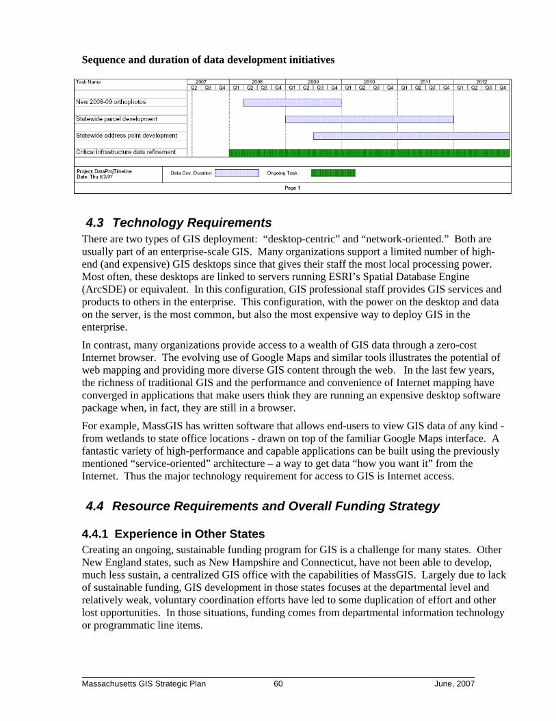
Sequence and duration of data development initiatives
4.3 Technology Requirements There are two types of GIS deployment: “desktop-centric” and “network-oriented.” Both are usually part of an enterprise-scale GIS. Many organizations support a limited number of high-end (and expensive) GIS desktops since that gives their staff the most local processing power. Most often, these desktops are linked to servers running ESRI’s Spatial Database Engine (ArcSDE) or equivalent. In this configuration, GIS professional staff provides GIS services and products to others in the enterprise. This configuration, with the power on the desktop and data on the server, is the most common, but also the most expensive way to deploy GIS in the enterprise.
In contrast, many organizations provide access to a wealth of GIS data through a zero-cost Internet browser. The evolving use of Google Maps and similar tools illustrates the potential of web mapping and providing more diverse GIS content through the web. In the last few years, the richness of traditional GIS and the performance and convenience of Internet mapping have converged in applications that make users think they are running an expensive desktop software package when, in fact, they are still in a browser.
For example, MassGIS has written software that allows end-users to view GIS data of any kind - from wetlands to state office locations - drawn on top of the familiar Google Maps interface. A fantastic variety of high-performance and capable applications can be built using the previously mentioned “service-oriented” architecture – a way to get data “how you want it” from the Internet. Thus the major technology requirement for access to GIS is Internet access.
4.4 Resource Requirements and Overall Funding Strategy
4.4.1 Experience in Other States Creating an ongoing, sustainable funding program for GIS is a challenge for many states. Other New England states, such as New Hampshire and Connecticut, have not been able to develop, much less sustain, a centralized GIS office with the capabilities of MassGIS. Largely due to lack of sustainable funding, GIS development in those states focuses at the departmental level and relatively weak, voluntary coordination efforts have led to some duplication of effort and other lost opportunities. In those situations, funding comes from departmental information technology or programmatic line items.
________________________________________________________________________ Massachusetts GIS Strategic Plan 60 June, 2007
At a national level, a one-size-fits-all funding strategy for statewide GIS offices has not emerged. Rather, each state has managed to fund their GIS through a variety of mechanisms that are often unique and innovative. In 2001, Ohio funded a study titled “Best Practices Report for the Ohio Spatial Data Cost-Benefit Analysis”16 that examined how each state funded their GIS programs. This study provided a useful, five category classification of funding strategies:
• Dedicated Funding. Identifies a recurring revenue stream and earmarks some portion of that revenue for geospatial activity. The best example is found in Wisconsin where a portion of property transfer and recording fees are dedicated to geospatial activities.
• Mission-Driven Funding. Identifies GIS technology as a key requirement to achieve a specific mission and provides line-item funds to meet that requirement. The Ohio study identified Maine and Oregon as examples, where E911 funding was directed to the state GIS offices to build E911 data and tools. The study identified other mission-driven funding streams like “smart growth” activities (both economic development and conservation) and management of public lands.
• Assessments on Agencies. Requires independent agencies to contribute to a central fund to create and maintain geospatial data and infrastructure. The Ohio study describes how Michigan’s core statewide data are funded by assessments on seven individual agencies that are major beneficiaries of the statewide data resources.
• Centralized, Capital Funding. Uses capital bond funding to support creating GIS resources. In fact, the Ohio study singles out Massachusetts as a leader for using this type of funding via the Executive Office of Environmental Affairs’ open space bond.
• Cost Recovery. Sells data and services to help support GIS operations. Massachusetts laws make public records available at the cost of duplication, nevertheless, this relatively small revenue stream can contribute to overall funding. Massachusetts collects approximately $50,000 per year from fees for data, maps and other services into a retained revenue account to support GIS.
After evaluating the funding strategies in all fifty states, with a more detailed look at fifteen, it was concluded that most states combine one or more of these strategies. This is certainly the case in Massachusetts where mission-driven, capital and cost recovery funding sources combine to support the Commonwealth’s geospatial activities.
4.4.2 Logical nexus between geospatial data initiatives and program needs For the past eight years MassGIS average annual budget (all sources, including project funding) has been about $2.17M per year. Funding came from a variety of sources, some sustainable, others not, and the funding varied from year to year - ranging from a peak of $3.59M in FY03 to a low of $1.47M in FY07. The following summarizes these funding sources and their average size over the last eight years (not discounted):
• Sustainable 44% o $334,279 Baseline legislative appropriation
(last four-years’ average was $281,120) o $ 50,054 Retained revenue from data distribution services
16 The study was authored by PlanGraphics, Inc. on behalf of the Ohio Geographically Referenced Information Program (OGRIP).
________________________________________________________________________ Massachusetts GIS Strategic Plan 61 June, 2007
o $542,934 Open Space/Environmental Bond funds for staffing o $109,036 Chargeback from EOEEA agencies
• Non-sustainable 56% o $960,027 Open Space/Environmental Bond project funds o $437,116 Other project funding
While there is significant funding associated with the status quo, there is also tremendous year-to-year uncertainty that make long-range planning difficult. In addition, MassGIS staff spend inordinate amounts of time putting together funding to keep current initiatives going. There is a logical nexus between existing Massachusetts funding sources and the initiatives recommended in Section 3. The following funding opportunities should be leveraged to the greatest extent possible.
• Bond funding such as EOEEA Open Space Bonds. This source authorized significant GIS funding over several iterations. More than $500,000 per year is allocated to cover most MassGIS staff positions. While this is effective at sustaining necessary staffing, it is fair to wonder whether using capital money to fund ongoing operational staff is sustainable over the longer term. Additional Open Space Bond funds were used for various data development projects including previous rounds of the orthophotos. Using this funding source for some of the capital projects recommended above may be appropriate. In particular, parcel data development may be a good candidate as parcels are critical for analyzing the Commonwealth’s existing open space holdings and for identifying possible new acquisitions.
• Secretary of the Commonwealth and Registry of Deeds Technology Fund. Since 2003 a $5 per document “technology surcharge” is imposed on all Registry of Deeds recording fees (with a few exceptions). These funds were invaluable in helping registries automate their back offices and move towards document management systems and scanned deeds. In at least one case, the Bristol County Northern District Registry, these funds were used to support parcel automation and link those parcels to registry documents. Given the obvious linkage between official recorded documents and the physical location of the parcels those documents describe, there is great benefit to integrating GIS mapping and the registries’ document management systems. The Technology Fund may help provide the resources to get this done in other registries.
• Executive Office of Transportation and Public Works (EOT), Federal Highway Planning Funds. As with the Open Space Bond, historically this has been a tremendously important funding source for GIS development. Federal Highway funds made key contributions to the 2001 and 2005 orthophoto programs as well as the two oblique imagery programs. Highway planning is inherently a geospatial activity and EOT has invested heavily in using this technology to support its federal reporting responsibilities. Having good underlying data – such as orthos and oblique images – is a key element of effective reporting and ongoing investments by EOT in these data sets are appropriate.
• Executive Office of Public Safety and Security (EOPSS) and State Emergency Telecommunications Board (SETB) E911 Surcharge Funds. Every cell phone and landline in the Commonwealth is assessed a monthly surcharge directed toward building,
________________________________________________________________________ Massachusetts GIS Strategic Plan 62 June, 2007

maintaining, and operating the E911 communications network in the Commonwealth. This surcharge generates tens of millions of dollars annually. Rhode Island and New Hampshire are constructing statewide address-point databases using this funding. The Governor’s office should direct EOPS to work with the SETB and MassGIS to ensure that E911 moves towards a system based on statewide address points maintained through surcharge revenues.
• EOPS and Federal Homeland Security Grant Program (HSGP). The federal government, through the Department of Homeland Security (DHS) has made it clear that geospatial data and technology investments are eligible uses of HSGP grant funding. So preparing an appropriate grant application becomes a matter of state priority. Does EOPS, as the state’s DHS designated Selected (grant) Administering Agency (SAA), consider geospatial investments important enough to warrant a focused effort to seek these funds? Connecticut and Wisconsin successfully obtained millions of dollars in funding for geospatial data development and system building.
• Executive Office of Administration and Finance (EOAF), Information Technology Division (ITD) Administrative Chargebacks. As described above, certain elements of a statewide GIS program are wholly communal in nature. No single agency is the primary beneficiary, and in fact, all state GIS users benefit. Perhaps the best example of this is the statewide orthophotos which over the past ten years have been funded by agencies as diverse as EOT, EOEEA, the Department of Public Health (DPH) and the Massachusetts Water Resources Authority (MWRA). In fact, all the key datasets discussed in this report should be treated as shared data resources. One potential mechanism for funding these efforts and combating the “free rider” issue is through administrative chargebacks across the universe of state agency GIS users. Such a chargeback mechanism is already in place within EOAF ITD and is used for state technology infrastructure such as email, wide-area networking and security. The same notion could apply to “GIS data maintenance” activities whereby the Commonwealth would exact smaller contributions from a broader base of users on an ongoing basis.
________________________________________________________________________ Massachusetts GIS Strategic Plan 63 June, 2007

The table below presents potential funding mechanism to achieve the recommendations described above in Section 3.
Recommendation
EOAF-ITD Line Item /
Chargeback
EOEA Open Space
Bond or other
Capital Funds
EOT FHA
Funds
Registry Technology
Fund
SETB E911
Surcharge Funds
EOPS Homeland Security Grants
#1: Regularize the orthophoto base mapping program (1) #2: Develop statewide 2 foot contour data set #3: Continue process improvements for updating road information
#4: Develop and maintain statewide parcel data #5: Development and maintain statewide address point data #6: Aggressively pursue DHS Homeland Security Grant Program funding for geospatial initiatives
#7 Strengthen geospatial technical assistance to local government #8: Re-organizeMassGIS operations into EOAF-ITD
Represents use of existing funding source for this activity Represents recommended potential funding source in future (1) The Department of Public Health contributed Bioterrorism funding towards the 2005 orthophoto program
________________________________________________________________________ Massachusetts GIS Strategic Plan 64 June, 2007

4.5 Standards Data standards are essential to achieving the type of regular and effective data sharing necessary to build a strong MSDI. Standards should guide the format, quality, and documentation of GIS data. Standards make it possible for data sets that are developed independently to be used together. For example, building a statewide parcel data set means dealing with 351 individual communities. If the parcel data from multiple communities are to be used together allowing a regional view, they must all be developed using the same standard, or at a least share a set of common attributes. Without a standard, making digital files from multiple communities compatible requires a prohibitive amount of work. During the workshops and interviews conducted for this project, attendees repeatedly stated that existing digital data standards are useful and that more standards are needed. Existing Commonwealth standards are summarized below followed by prospective standards identified during the workshops and interviews.
4.5.1 Existing MassGIS Standards The following provides a brief abstract of the three standards currently issued by MassGIS17: 1. Standard for Digital Parcel Files MassGIS issued the first version of its Standard for Digital Parcels in 2001 with the current version released in 2004. MassGIS staff is expecting to develop Version 2.0 in 2007. The digital parcel standard aims to:
• Provide communities a flexible specification for developing a digital parcel file to use in a GIS.
• Enable parcel maps from multiple communities to be merged for multi-town displays and analysis.
• Establish a method of uniquely identifying parcels across the state.
• Assure a minimum level of spatial accuracy.
• Assure a minimum and consistent set of descriptive assessing information.
The digital parcel standard is mature and is successfully implemented in approximately fifty Massachusetts communities. The well-received standard is regarded as reasonable and is based on generally accepted practices. A testimonial to its usefulness is its use as a model for similar standards developed by other New England states. 2. Standard for Digital Plan Submission to Municipalities Many cities and towns have realized that plans submitted for development review are usually produced with computer aided design and drafting (CADD) software. Some communities now require that copies of the CADD files be submitted and many more municipalities are considering such a requirement. Municipalities recognize
“Obtaining plans in a standardized digital form is very valuable for easing maintenance of parcel maps.” -Andrew Port Hanover Town Planner
17 To view MassGIS’ existing standards, visit http://www.mass.gov/mgis/standards.htm
________________________________________________________________________ Massachusetts GIS Strategic Plan 65 June, 2007
that implementing this requirement will facilitate maintaining their GIS databases because data sets such as parcel boundaries, road rights-of-way, pipe infrastructure and building outlines are contained on these CADD plans. Since CADD files coming from different developers or engineering firms can be different, many municipalities now implement, or are considering implementing, standards for the format and content of CADD plans so that all submitted plans are similar. Based on feedback from the stakeholder community, MassGIS developed a model standard that can be adopted by individual municipalities. The MassGIS standard enables:
• Municipalities to use a reliable standard created with contributions and review by experts whose experience with municipal data and procedures guided their recommendations and comments.
• Surveyors and civil engineers to standardize their work processes across the state for considerable time and costs savings.
Version 1.0 of the standard was released in February 2006. A revision will likely be released in 2007, incorporating changes that address concerns expressed by the surveying and engineering professions. 3. Standard for Regional Water, Wastewater, and Storm Drain Infrastructure Municipal information about pipes (e.g. water, sewer, stormwater) is increasingly being incorporated into local GIS. As with parcels, standardizing this information will facilitate aggregating community data from multiple sources into regional views. The MassGIS Pipe Infrastructure Standard has five goals:
• Provide a flexible, yet consistent, specification for compiling pipe locations in GIS.
• Provide a standard to compile the boundaries of service territories for pipe infrastructure.
• Provide a standardized subset of attributes for pipe data in GIS.
• Make it possible to merge digital utility data from more than one community for regional mapping and analysis.
• Prevent “re-inventing the wheel” by providing a standard based on generally accepted design requirements.
Version 1 of the standard was released in October of 2005, but it only covers data developed for regional planning purposes. The standard allows for, but does not yet include, a further refinement that recognizes the much more detailed requirements of municipal GIS databases. Such a standard would be an important starting place for municipal pipe GIS database development. MassGIS hopes that work on a new, expanded version of the standard that better addresses local needs will commence in the coming year.
4.5.2 Recommended Standards Workshop and interview participants identified numerous additional GIS data sets that would benefit from a state-level standard. Below is a brief abstract of these data sets and what the standard setting activity entails. For standards to be widely accepted, those impacted must have a say in developing the standard. Each standard developed by MassGIS followed a highly inclusive process whereby stakeholders affected by the standard had opportunities to help shape
________________________________________________________________________ Massachusetts GIS Strategic Plan 66 June, 2007

it. Such a broad based development process would be employed for any future standard setting initiatives. 1. Orthophoto Due to the highly technical nature of procurements for orthophotos (and other photogrammetric products), MassGIS can significantly help communities by developing a standard specification for orthophoto base map procurements. The most effective mechanism for this assistance might be to work with the state’s Operational Services Division on a procurement that would lead to a Master Service Agreement (MSA) under which communities could procure standard orthophoto base map products. This would ensure that community expenditures result in a standard, broadly useful product. MassGIS initiated discussions with municipal GIS staff in late 2006 concerning such an MSA and is planning to have it in place by September of 2007. 2. Road Centerline Almost all communities have a road centerline data set in their GIS. Similarly, the Executive Office of Transportation maintains a statewide road centerline data set. As discussed above, it would be highly beneficial to merge local updates into the statewide dataset. Workshop and interview participants agreed that having a statewide data standard for road centerlines would facilitate and foster this type of data sharing. Most likely, this standard would be based on the existing statewide road centerline data maintained by EOT and would address three principal areas:
• The geometric representation of the roads, including defining what constitutes a road segment, how to represent complex intersections and divided highways/roads, public vs. private streets, etc.
• The descriptive or attribute information associated with each road (e.g. standardizing road naming)
Mapping student locations as part of a school re-districting study; each student is color-coded based on their grade.
• A system of “linear referencing” that enables different levels of government to model the many characteristics of roads that do not start and stop with road intersections (e.g., pavement condition).
Developing such a standard will be a challenging undertaking as different state agencies (EOT, E911) have different needs; as do transportation planners at the regional planning agencies, and DPW staff at the municipal level. 3. Street addresses A great deal of information in government is associated with an address: for example, the location of an environmental permit, a cancer incident, a student’s address in a school system or in a building that the Commonwealth owns. Similarly, addresses are the most common method people use to identify where they are (e.g., 911 calls) or where they want to go, making a standard
________________________________________________________________________ Massachusetts GIS Strategic Plan 67 June, 2007

for street addresses imperative. This has already been recognized by national standards bodies such as the Urban and Regional Information Systems Association (URISA) and the Federal Geographic Data Committee (FGDC) who are working on an addressing standard, which MassGIS expects to implement. 4. Critical Infrastructure and Sensitive Population Locations Mapping of critical infrastructure and sensitive populations are derived from data that are collected by multiple levels of government. As with parcels, if these independently collected data are to be used together, then there must be a clear and strong standard. Massachusetts should continue to monitor and participate in the development and review of the evolving national standards for critical infrastructure data. As these standards are formally released, Massachusetts should adopt them.
4.6 Organizational Requirements Massachusetts has a reasonably effective organizational model in place. However, several refinements and improvements will increase the chances of MSDI being successfully deployed.
4.6.1 Executive Support Currently, MassGIS is a small program tucked away in a relatively small Executive Office of Energy and Environmental Affairs (EOEEA). In spite of its broad constituency and interaction with a very wide group of stakeholders, MassGIS has not generally had a strong, senior level advocate to provide crucial executive support. A few exceptions illustrate the importance of such executive support. First, in the late 1980’s during the early days of MassGIS development, then Representative David Cohen (now Mayor of Newton) advocated strongly for developing the state’s GIS as it was instrumental to helping pass a watershed protection measure that he sponsored. This support led directly to new investments in high quality GIS data. Then during the tenure of Secretary of the Environment, Bob Durand (1999 - 2003), MassGIS was key in supporting the Secretary’s aggressive Community Preservation agenda and substantial investments were made in GIS data and capabilities. No matter the reason, gaining executive level support and attention will be instrumental in achieving the significant investments that are called for in this plan.
4.6.2 Coordination and Oversight Procedures Relatively informal oversight procedures were established by the 1999 legislation that established MassGIS as the Commonwealth’s geospatial coordinating body. Although the legislation created what is now called the Massachusetts Geographic Information Council (MGIC), its membership and role were not clearly defined. It serves mostly as a useful advisory sounding board and does not play a role in geographic information policy setting or strategic planning. Going forward, as Massachusetts organizes GIS around the concept of MSDI, there will be benefits to further formalizing the coordination and oversight procedures of MassGIS. This may include having each Executive Office engaged in GIS formally designate a representative to the advisory committee. This would help ensure that all GIS agencies are represented, can inform policy, and create a broad consensus behind new initiatives and the strategic vision for the MSDI.
________________________________________________________________________ Massachusetts GIS Strategic Plan 68 June, 2007
4.6.3 Enhancing Coordination Authority While the 1999 legislation established MassGIS as the GIS coordinating body for the Commonwealth, and while MassGIS has had success with an informal approach to coordination, the legislation did not provide any enforcement authority and there have been some missed opportunities. As the Commonwealth works to establish the MSDI, it may be beneficial to provide some level of authority to address issues such as:
• Requiring conformance to data standards • Coordinating software purchases and maintenance • Developing web services for agency use • Administering equitable collective/communal funding for statewide data maintenance
One potential mechanism for providing this authority is to coordinate the MassGIS standards-setting mandate with EOAF ITD’s existing authority over information technology.
4.6.4 Strongly Encourage Federal Government to Better Coordinate Although this strategic planning effort is funded by the federal government, it must be noted that, from the state’s perspective, the federal government could do a better job coordinating its geospatial programs that interface with the states. Coordination is a two-way street and as Massachusetts makes earnest efforts to be a better, collaborating partner, so too should the federal government. Right now, many separate federal agencies interact with the state via a variety of programs with geospatial components that include, but are not limited to:
• Centers for Disease Control (Cancer Registry) • Department of Defense (Critical Infrastructure) • Department of Homeland Security (All Hazards Mitigation; Bioterrorism) • Environmental Protection Agency (various national permitting programs) • Federal Highway Administration (Highway Trust Fund) • United States Geological Survey (Water Resources) • United States Census (Decennial Census)
While each of these agencies has a legitimate “vertical” connection to a partner agency, these federal agencies should encourage additional coordination with the state’s lead geospatial entity on matters pertaining to geospatial technology and data, i.e. MassGIS. Could there be a more active federal liaison to help the whole range of independent federal programs coordinate with their state partners? When multiple federal entities independently pursue and support critical infrastructure data collection with different state, regional and local partners, there are significant opportunities for improvement. Just as the states need to re-examine their internal coordination, the federal government needs to examine and reform its side of the equation.
4.7 Policies and Mandates A few opportunities to set policies that could have positive impacts on the development and maintenance of the MSDI can be identified. Ultimately, these policies would provide for a sustainable and ongoing approach to spatial data infrastructure
1. Require that the E911 emergency service listing contain an explicit X,Y coordinate for each address. Currently, physically locating an address in the master street
________________________________________________________________________ Massachusetts GIS Strategic Plan 69 June, 2007
address list of phone service addresses (maintained by the Commonwealth’s E911 provider Verizon) can only be done by interpolating against a road centerline database. While this technology does a reasonable job of locating addresses, the interpolation can also generate errors greater than 400 feet, which complicate emergency response. Vermont, New Hampshire and Rhode Island have completed projects that identify a specific point location for every address in the state. With such a system in place, interpolation errors would be eliminated and accurate statewide addressing would be available for E911 as well as a wide variety of applications outside the realm of public safety. Clearly the technology exists to build such a resource and in several other New England states, the E911 surcharge was adequate to fund creating this resource. Massachusetts should make point locations a requirement for the master address list behind the E911 system.
2. Develop better incentives and/or penalties to ensure that municipalities report all new roads to the Executive Office of Transportation and Public Works (EOT). Since Chapter 90 monies are allocated using a formula that reflects total road mileage in a community, there is a strong incentive for communities to report “new mileage” to EOT on a timely and regular basis. According to EOT the Chapter 90 formula equates to approximately $4,000 of additional Chapter 90 funding for every new mile of road. Nevertheless, EOT reports that voluntary community reporting of new streets is not reliable, and approximately only 30% of communities voluntarily report on an annual basis18 leaving 70% that probably have something to report. Having all communities report on a timely basis would simplify the process of keeping a multi-purpose statewide road inventory current. EOT should determine whether further incentives, or perhaps penalties, might increase reporting. Ultimately, EOT is only one of many beneficiaries of an accurate and current statewide road inventory. Working with EOT and other organizations as appropriate, MassGIS should work to educate public officials about the importance of submitting road updates for transportation funding and planning and for public safety. 3. Require communities to store their parcel inventories in electronic format and provide updates to the Department of Revenue annually. Currently, the Department of Revenue (DOR) requires that communities maintain a set of maps that comprehensively catalog all of a community’s parcels. It also requires this series of maps to be updated annually. While these requirements exist, enforcement is not strong. Equally, there is legitimate hesitation to require the development and maintenance of electronic parcel data due its perception as an “unfunded mandate”. However, if Recommendation #5 from Section 3 is followed, then the Commonwealth would provide funding to create a statewide electronic parcel data set. At that juncture, DOR should consider revising its policy so there is a requirement to submit electronic parcel data annually. GIS technologies can also provide DOR with new tools to ensure that updated parcel data are submitted properly every year.
4. Require compliance with the MassGIS digital parcel standard where any state monies are used for digital parcel creation. Completing the statewide parcel layer (Recommendation #5 in Section 3) will take time and during that time individual parcel development efforts will continue. Therefore, there should be a comprehensive policy that any
18 EOT does not have data on how many of the 70% of communities that did not report new road mileage actually had new road construction, and it is reasonable to assume that some communities do not build new roads every year.
________________________________________________________________________ Massachusetts GIS Strategic Plan 70 June, 2007
state money used to support parcel automation result in a product that conforms to the MassGIS digital parcel standard. Unfortunately, grants for community development or homeland security have been used to support local parcel automation efforts that were not standards compliant. Such a policy would aim to prevent this type of lost opportunity going forward.
5. Develop targeted homeland security grant applications for geospatial data and infrastructure investments. Homeland security grants can be used to support a broad array of required emergency preparedness improvements ranging from communication and radio upgrades to procuring chemical suits to geospatial data and technology. Previous administrations, in spite of broad GIS use within the Executive Office of Public Safety and Security, especially within MEMA and the State Police, did not target any homeland security grant funding towards geospatial investments. Indeed, at a national level, this is a common problem - the federal Department of Homeland Security (DHS) reports that there were relatively few grant applications for funds earmarked for geospatial activities. Given the lack of competition, EOPS should strongly consider a policy of aggressively pursuing federal grant opportunities aimed specifically at geospatial data and technology initiatives. Such a funding source could develop parcel and address point data sets with enormous benefits to both the public safety community and a much broader set of GIS users.
6. Coordinate the state’s orthophoto and oblique imagery acquisition programs. Currently, the Commonwealth administers two distinct and important aerial photography initiatives: the digital orthophoto program and the oblique imagery program. The Commonwealth completed the third round of the orthophoto program in 2006 and has just recently awarded the second round of the oblique imagery program. While the end products are different and complementary, the technologies involved in their creation are similar, and are converging. The Commonwealth should consider formally coordinating these historically independent efforts. First, economies-of-scale and lower costs could be achieved with a single coordinated program. Second, potential to stagger the flights gives the Commonwealth some form of imagery covering more individual years, increasing the timeliness of change detection.
7. Set a statewide policy identifying which critical infrastructure geospatial data sets should be exempt from Freedom of Information requests. Currently, there is some confusion about which types of critical infrastructure data should be exempt from Freedom of Information (FOI) requests. For example, does a data set that has the location of every fire station in the Commonwealth need to be “protected”? There are competing public interests in making these data available and in ensuring that releasing the data does not compromise public safety. At present there is no clear guidance on what should be “public.” Legislative exemptions that allow data custodians to withhold certain categories of data based on security concerns have been stretched to include data whose release does not present any conceivable security risk. It is recommended that a multi-agency working group examine the universe of critical infrastructure and sensitive population data sets and make a final determination of which data sets should be protected.
________________________________________________________________________ Massachusetts GIS Strategic Plan 71 June, 2007

4.8 Staffing and Budget Requirements
4.8.1 Staffing Requirements If the Commonwealth moves forward with the full set of recommendations presented above two new significant data sets will be developed and will require ongoing maintenance. As such, there will be a requirement for two new “data custodian” positions for the parcels and address points. These staff will manage the initial data development efforts and then will move into a data maintenance role where a key aspect will be ongoing outreach and coordination with the municipal stakeholders who will be integral to the data updating process.
4.8.2 Budget Requirements Below are budget estimates for implementing the recommendations set forth in this report:
Recommendation Cost Type
Low Estimate
High Estimate Note
#1: Regularize the orthophoto base mapping program
Tri-annual $800,000 $1,200,000
Cost will depend on orthophoto resolution and continued technological improvement which has driven the price downward over the last 10 years.
#2: Development statewide high resolution elevation data
One-time $1,500,000 $2,000,000
Cost will depend heavily on the direct and derivative products that are specified
#3: Process improvements for timely road update n/a - -
No new spending recommended; policy adjustments and process improvement.
#4: Complete standardized statewide parcel data;
One-time $2,500,000 $3,000,000
Potential to control costs by using incentive grants to communities.
(a) Funding
from E911; 3
yr. project $2,000,000 $3,000,000
Cost will depend on the approach taken, and the potential availability of statewide parcel data (which would lower cost). It is recommend that a detailed scoping study be undertaken on this initiative and this will refine cost further.
#5: (a) Development statewide address point data; (b) annual maintainenance of statewide address point data
(b) Annual $100,000 $150,000 Cost for staff and expenses
#6: Aggressively pursue DHS Homeland Security Grant Program funding for geospatial initiatives n/a - -
No new spending recommended; rather a policy focus on pursuing the funds. If successful, spending would match the grant amount.
#7 Fund regional entities to provide technical support to local governments Annual $500,000 $1,000,000
#8: Ongoing funding for Statewide GIS Program Annual $1,100,000 $1,300,000
Low is based on current costs; high is based on adding 2 additional “data custodians” as discussed above.
TOTAL Annual $2,500,000 $3,650,000
TOTAL One-Time $6,000,000 $8,000,000
________________________________________________________________________ Massachusetts GIS Strategic Plan 72 June, 2007

APPENDIX A:
Agencies and Individuals Participating in Strategic Plan Interviews
Organization Individuals Metropolitan Area Planning Council Marc Draisen, Executive Director Holly St. Clair, Data Center Manager Allan Bishop, GIS Manager Massachusetts Board of Real-Estate Appraisers Sean Fitzgerald, President Bill Pastuszek, past MBREA President UMASS-Amherst Steve Mabee, State Geologist, Geology Department
Jack Ahern, Landscape Architecture and Regional Planning
Qian Yu - Assistant Professor, Department of Geosciences
Maxine Schmidt, Integrated Science and Engineering Library
State Police, Commonwealth Fusion Center Major Dermot Quinn, Commanding Officer
Sergeant Bob Sojka, Point of Contact for Critical Infrastructure in Massachusetts
Brian Egnitz, GIS Program Coordinator Massachusetts Emergency Management Agency John Tommaney, Response and Recovery Branch Chief Scott McCloud, Mitigation Grants Manager Rob Sousa, Planner Johanna Meyer, GIS Coordinator Office of the Governor David Simas, Deputy Chief of Staff Registers of Deeds under Secretary of the Commonwealth All Registers of Deeds reporting to the Secretary Division of Capital Asset Management H. Peter Norstrand, Deputy Commissioner, Real Estate
Marc Nelson, Deputy Commissioner, Facilities Management
Stephen Andrews, Deputy Directory, Real Estate Bill Tivnan, Director of the Office of Finance Michael Orcutt, System Administrator Linda Alexander, Program Coordinator Massachusetts Water Resources Authority Steve Estes-Smargiasi, Director of Planning Daniel Nvule, Sr. Program Manager Glenn Hazelton, GIS Database Administrator Pakyen Lim, Program Manager
________________________________________________________________________ Massachusetts GIS Strategic Plan 73 June, 2007

Executive Office of Environment and Energy Jane Corr, Chief of Staff Phil Griffiths, Deputy Secretary for Environment Bob Wilbur, Chief Information Officer Information Technology Division Bethann Pepoli, Acting CIO Stewart Lecky, Chief Operating Officer
Conservation Organizations Jennifer Ryan, Assistant Director of Legislative Affairs, Mass. Audubon
Jeff Collins, GIS Manager, Mass. Audubon
Andrew Finton, Director of Conservation Science, The Nature Conservancy
Katie Andrews, GIS Manager, The Nature Conservancy Vincent Antil, GIS Manager, Trustees of Reservations
James DeNormandy, GIS Specialist, DFG-Department of Forestry
Phil Trusdale, MassWildlife
David Kimball, GIS Analyst, Department of Conservation and Recreation
Massport George Ditullio, GIS Specialist US EPA - Region I Mke McDougall, Chief, Information Management Alexandra Dichter, GIS Manager Tom Giffen, GIS Technical Coordinator Massachusetts National Guard Kevin Bartsch, GIS Manager Massachusetts Association of Land Surveyors and Civil Engineers Ken Anderson, President, MALSCE and American Council of Engineering Companies Mike Haulon, President, ACEC Scott Cameron, Cameron and Associates Rich Gosselin, Northeast Engineers and Consultants David Humphrey, Schofield Brothers of New England Massachusetts Licensed Site Professionals Association David R. McDonald, President Environmental Business Council - Technology Committee Michael Hamilton, Harris Miller Miller and Hansen, Inc. Mark Maguire, Epsilon Associates Gregory Rowe, ESS Group, Inc. Executive Office of Transportation and Public Works Ken Miller, Director (at time of interview) Office of Transportation Planning Mark Berger, Data Resources Manager
________________________________________________________________________ Massachusetts GIS Strategic Plan 74 June, 2007
USDA-Natural Resource Conservation Service Christine Clarke, State Conservationist Barbara Miller, GIS Analyst
Executive Office of Environment and Energy Brian Brodeur, GIS Manager, Department of Environmental Protection
Steve McRae, Acting CIO and GIS Manager, Department of Fish and Game
Nathanael Lloyd, GIS Manager, Department of Conservation and Recreation
Daniel Sampson, GIS Coordinator, Office of Coastal Zone Management
________________________________________________________________________ Massachusetts GIS Strategic Plan 75 June, 2007