Embed Size (px)
Citation preview
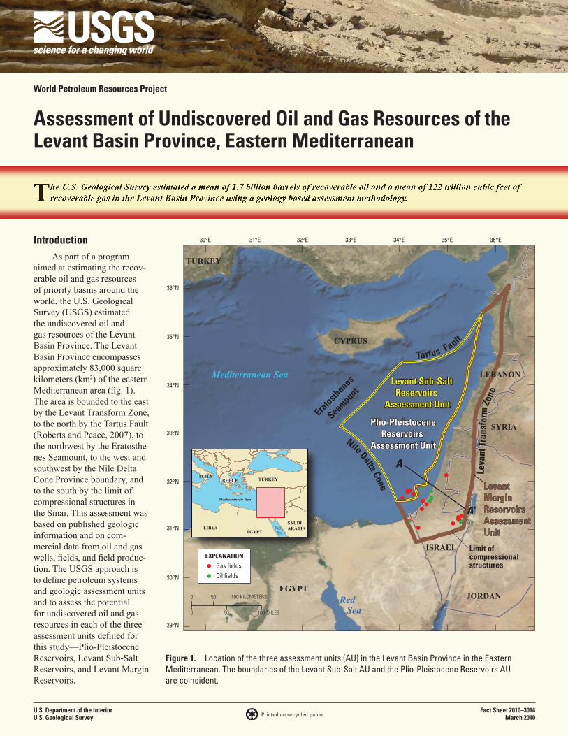
Figure 1. Location of the three assessment units (AU) in the Levant Basin Province in the Eastern Mediterranean. The boundaries of the Levant Sub-Salt AU and the Plio-Pleistocene Reservoirs AU are coincident.
Mediterranean Sea
Red Sea
36°E35°E34°E33°E32°E31°E30°E
36°N
35°N
34°N
33°N
32°N
31°N
30°N
29°N
0 50 100 MILES
0 50 100 KILOMETERSEGYPT
ISRAEL
CYPRUS
TURKEY
JORDAN
SYRIA
LEBANON
EXPLANATIONGas fields
Oil fields
Levant Sub-SaltReservoirs
Assessment Unit
Plio-PleistoceneReservoirs
Assessment Unit
TURKEY
EGYPTLIBYA
SAUDIARABIA
Mediterranean Sea
Red Sea
GREECEITALY
LevantMargin ReservoirsAssessment Unit
Leva
nt T
rans
formEratosth
enes
Seamount Tartus Fault
Nile Delta Cone
A
A’
Zone
Limit of compressional structures
U.S. Department of the InteriorU.S. Geological Survey
Fact Sheet 2010–3014March 2010
World Petroleum Resources Project
Assessment of Undiscovered Oil and Gas Resources of the Levant Basin Province, Eastern Mediterranean
Printed on recycled paper
IntroductionAs part of a program
aimed at estimating the recov-erable oil and gas resources of priority basins around the world, the U.S. Geological Survey (USGS) estimated the undiscovered oil and gas resources of the Levant Basin Province. The Levant Basin Province encompasses approximately 83,000 square kilometers (km2) of the eastern Mediterranean area (fig. 1). The area is bounded to the east by the Levant Transform Zone, to the north by the Tartus Fault (Roberts and Peace, 2007), to the northwest by the Eratosthe-nes Seamount, to the west and southwest by the Nile Delta Cone Province boundary, and to the south by the limit of compressional structures in the Sinai. This assessment was based on published geologic information and on com-mercial data from oil and gas wells, fields, and field produc-tion. The USGS approach is to define petroleum systems and geologic assessment units and to assess the potential for undiscovered oil and gas resources in each of the three assessment units defined for this study—Plio-Pleistocene Reservoirs, Levant Sub-Salt Reservoirs, and Levant Margin Reservoirs.

Figure 2. Geologic cross section of the southern part of the Levant Basin Province illustrating the definition of the three assessment units (AU) in this study. The areas of the Levant Sub-Salt Reservoirs AU and the Plio-Pleistocene Reservoirs AU are coincident, and neither AU overlaps with the Levant Margin Reservoirs AU. Dashed line separates Cenozoic (above) from pre-Cenozoic rocks. Messinian-age salt (between the M and N seismic horizons) is shown in green. Location of schematic section (A-A’) shown in figure 1. A, Permian to Aalenian age; B, Bajocian to Turonian age; C, Senonian to Early Oligocene age; D, Oligocene to Late Miocene Age; E, Late Miocene (Messinian) age; F, Plio-Pleistocene age rocks. Modified from Gardosh and Druckman (2006) and Cartwright and Jackson (2008).
100 MILES0
50 KILOMETERS0
NW SE
10
8
6
4
2
Basement
M Horizon
N Horizon
Two-
Way
Tim
e (s
econ
ds)
Levant Sub-Salt Reservoirs AU
Levant MarginReservoirs
Assessment Unit
Plio-Pleistocene Reservoirs Assessment Unit
Levant Basin Levant MarginA A’
Jordanriftvalley
LevantTransformzone
Sea level
A
B
C
D
E
F
Composite Petroleum System and Assessment UnitsFor this assessment the Mesozoic-Cenozoic Composite Pe-
troleum System was defined to include the possibility of viable petroleum source rocks of Triassic, Jurassic, Lower Cretaceous, Upper Cretaceous, Miocene, and Plio-Pleistocene ages, all of which have been suggested as potential source rocks within this province. This composite petroleum system was defined to encompass all petroleum fluids and mixtures of these fluids in the Levant Basin Province because we could not completely discriminate between genetic families of oils or gases with available geochemical data.
Three assessment units (AU) were defined geologically within the composite petroleum system. The Levant Margin Reservoirs AU encompasses all reservoirs, from basement rocks to the Pleistocene, occurring east of the pinch-out of Messinian-age salt and west of the Levant Transform (fig. 2). Reservoirs include Jurassic and Cretaceous shelf-margin carbonates, nearshore marine sandstones, and deep-water slope and fan sandstones. The Levant Sub-Salt Reservoirs AU encompasses all reservoirs within and below continuous Messinian-age salt west of the eastward pinch-out of the salt (fig. 2). Reservoirs are mainly Mesozoic and Paleogene sandstones ranging from incised valley deposits to deep-water slope and fan sandstones (Gardosh and others, 2006; 2008). The Plio-Pleistocene Res-ervoirs AU includes all reservoirs younger than Messinian-age
salt west of the pinch-out of salt, and reservoirs mainly are incised channels, and deep-water slope and fan sandstones (Aal and others, 2000; Bertoni and Cartwright, 2006) (fig. 2). The Plio-Pleistocene Reservoirs AU is thought to be sourced mainly by biogenic gas, but this assessment includes the possibility of thermogenic gas and oil that migrated vertically from sub-salt source rocks. The Levant Margin Reservoirs AU contains four oil and four gas fields, the Plio-Pleistocene Reservoirs AU includes eight gas fields, and the Levant Sub-Salt Reservoirs AU has two discoveries (Tamar, Datil) that were used in the assessment but are so new that there is no independent refer-ence as to the size of these discoveries. For this assessment a minimum undiscovered field size of 5 million barrels of oil equivalent (MMBOE) was used for the offshore assessment and a 1 MMBOE minimum was used for the onshore assessment.
Resource SummaryEstimates of volumes of undiscovered technically recover-
able oil and gas resources are shown in table 1. The mean of the distribution for undiscovered oil is about 1,689 MMBO, with a range from 483 MMBO to 3,759 MMBO. For undiscovered gas, the total mean volume is 122,378 billion cubic feet of gas (BCFG), with a range from 50,087 BCFG to 227,430 BCFG. Of the 122,378 BCFG, 6,197 BCFG is estimated to be in the Levant Margin Reservoirs AU, 81,437 BCFG is in the

Eocene nearshore marine sandstones and limestones, Wadi Degla, northern Egypt.
Table 1. Levant Basin Province assessment results.
[MMBO, million barrels of oil; BCFG, billion cubic feet of gas; MMBNGL, million barrels of natural gas liquids. Results shown are fully risked estimates. For gas accumulations, all liquids are included as NGL (natural gas liquids). Undiscovered gas resources are the sum of nonassociated and associated gas. Largest mean oil field in MMBO; largest mean gas field in BCFG. F95 represents a 95 percent chance of at least the amount tabulated. Other fractiles are defined similarly. TPS, total petroleum system; AU, assessment unit. Gray shading indicates not applicable]
Total Petroleum Systems (TPS) and Assessment Units
(AU)
Field type
Largest expected
mean field size
Total undiscovered resources
Oil (MMBO)
Gas (BCFG)
NGL (MMBNGL)
F95 F50 F5 Mean F95 F50 F5 Mean F95 F50 F5 Mean
Levant Basin Province, Mesozoic-Cenozoic Composite TPS
Levant Margin Reservoirs AU
Oil 177 278 763 1,765 857 340 944 2,202 1,062 7 19 45 22Gas 1,074 1,678 4,559 10,594 5,135 51 142 333 160
Levant Sub-Salt Reservoirs AU
Oil 184 148 460 1,242 548 179 569 1,559 679 4 12 32 14Gas 12,238 32,462 74,210 150,573 80,758 1,006 2,309 4,721 2,519
Plio-Pleistocene Reservoirs AU
Oil 130 57 217 752 284 68 265 933 351 1 5 19 7Gas 4,756 15,360 32,066 61,569 34,393 157 328 633 353
Total Conventional Resources
483 1,440 3,759 1,689 50,087 112,613 227,430 122,378 1,226 2,815 5,783 3,075

Levant Sub-Salt Reservoirs, and 34,744 BCFG is in the Plio-Pleistocene Reservoirs AU (table 1). These estimates represent technically recoverable oil and gas resources; no attempt was made to estimate economically recoverable resources.
References Cited
Aal, A.A., Barkooky, A.E., Gerrits, M., Meyer, H., Schwander, M., and Zaki, H., 2000, Tectonic evolution of the Eastern Mediterranean Basin and its significance for hydrocarbon prospectivity in the ultradeep water of the Nile Delta: The Leading Edge, October 2000, p. 1086–1102.
Bertoni, C., and Cartwright, J.A., 2006, Controls on the basin-wide architecture of late Miocene (Messinian) evaporites on the Levant margin (Eastern Mediterranean): Sedimentary Geology, v. 188–189, p. 93–114.
Cartwright, J.A., and Jackson, M.P.A., 2008, Initiation of gravi-tational collapse of an evaporate basin margin: the Messinian saline giant, Levant Basin, eastern Mediterranean: Geological Society of America Bulletin, v. 120, no. 3–4, p. 399–413.
Gardosh, M., and Druckman, Y., 2006, Seismic stratigraphy, structure and tectonic evolution of the Levantine Basin, off-shore Israel, in Robertson, A.H.F., and Mountrakis, D., eds., Tectonic development of the eastern Mediterranean Region: Geological Society of London Special Publication no. 260, p. 201–227.
Gardosh, M., Druckman, Y., Buchbinder, B., and Calvo, R., 2008, The Oligo-Miocene deepwater system of the Levant Basin: Geophysical Institute of Israel Report 446/426/08 and Geological Survey of Israel Report GSI/33/2008, 73 p.
Gardosh, M., Druckman, Y., Buchbinder, B., and Rybakov, M., 2006, The Levant Basin offshore Israel: stratigra-phy, structure, tectonic evolution and implications for hydrocarbon exploration: Geophysical Institute of Israel Report 429/218/06 and Geological Survey of Israel Report GSI/14/2006, 119 p.
Roberts, G., and Peace, D., 2007, Hydrocarbon plays and prospectivity of the Levantine Basin, offshore Lebanon and Syria from modern seismic data: GeoArabia, v. 12, no. 3, p. 99–124.