Embed Size (px)
Citation preview
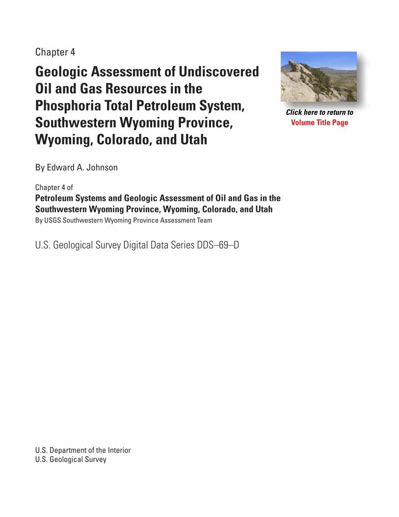
Chapter 4
Geologic Assessment of Undiscovered Oil and Gas Resources in the Phosphoria Total Petroleum System, Southwestern Wyoming Province, Wyoming, Colorado, and Utah
By Edward A. Johnson
U.S. Geological Survey Digital Data Series DDS–69–D
U.S. Department of the Interior U.S. Geological Survey
Chapter 4 ofPetroleum Systems and Geologic Assessment of Oil and Gas in theSouthwestern Wyoming Province, Wyoming, Colorado, and UtahBy USGS Southwestern Wyoming Province Assessment Team
Volume Title Page
U.S. Department of the Interior Gale A. Norton, Secretary
U.S. Geological Survey Charles G. Groat, Director
U.S. Geological Survey, Denver, Colorado: Version 1, 2005
For sale by U.S. Geological Survey, Information Services
Box 25286, Denver Federal Center
Denver, CO 80225
For product and ordering information:
World Wide Web: http://www.usgs.gov/pubprod
Telephone: 1-888-ASK-USGS
For more information on the USGS—the Federal source for science about the Earth, its natural and living resources,
natural hazards, and the environment:
World Wide Web: http://www.usgs.gov
Telephone: 1-888-ASK-USGS
Although this report is in the public domain, permission must be secured from the individual copyright owners to
reproduce any copyrighted materials contained within this report.
Any use of trade, product, or firm names in this publication is for descriptive purposes only and does not imply
endorsement by the U.S. Government.
Manuscript approved for publication May 10, 2005
ISBN= 0-607-99027-9
Contents
Abstract ……………………………………………………………………………………… 1Introduction …………………………………………………………………………………… 1Total Petroleum System ……………………………………………………………………… 3Source Rock ………………………………………………………………………………… 11Maturation …………………………………………………………………………………… 11Migration Summary …………………………………………………………………………… 14Reservoir Rocks ……………………………………………………………………………… 18
Crystalline Rocks ………………………………………………………………………… 19Flathead Sandstone ……………………………………………………………………… 21Bighorn Dolomite ………………………………………………………………………… 21Madison Limestone ……………………………………………………………………… 21Darwin Sandstone Member ……………………………………………………………… 22Amsden Formation ……………………………………………………………………… 22Minturn Formation ……………………………………………………………………… 22Morgan Formation ……………………………………………………………………… 22Weber Sandstone ……………………………………………………………………… 23Tensleep Sandstone …………………………………………………………………… 23Phosphoria Formation …………………………………………………………………… 24Red Peak Formation ……………………………………………………………………… 25Shinarump Member ……………………………………………………………………… 25Nugget Sandstone ……………………………………………………………………… 25Entrada Sandstone ……………………………………………………………………… 26Curtis Formation ………………………………………………………………………… 27Sundance Formation …………………………………………………………………… 27Morrison Formation ……………………………………………………………………… 28
Traps and Seals ……………………………………………………………………………… 28Source Rock Seal ……………………………………………………………………… 28Traps …………………………………………………………………………………… 29Reservoir Seals ………………………………………………………………………… 29
Precambrian-Cambrian Level ……………………………………………………… 30Ordovician Level …………………………………………………………………… 31Mississippian-Pennsylvanian Level ………………………………………………… 31Permian Level ……………………………………………………………………… 31Triassic-Jurassic Level …………………………………………………………… 31Reservoir Seals in the Sandwash Basin …………………………………………… 32
Sub-Cretaceous Conventional Oil and Gas Assessment unit ………………………………… 32References Cited ……………………………………………………………………………… 40
III
Appendix A. Input data form used in evaluating the Sub-Cretaceous Conventional Oil and Gas Assessment Unit ………………………………………………………………… 45Appendix B. Summary of assessment results for the Phosphoria Total Petroleum System, Sub-Cretaceous Conventional Oil and Gas Assessment Unit 3. Source rocks and type of petroleum potential for burial-history locations ………………………………………… 46
Figures
1. Index map of Southwestern Wyoming Province ……………………………………… 2 2. Stratigraphic columns for Southwestern Wyoming Province ………………………… 4 3–7. Maps showing: 3. Regional extent of the Phosphoria and Park City Formations …………………… 8 4. Southwestern Wyoming Province related to the Phosphoria and Park City Formations 9 5. Cumulative thickness of black shale facies of the Phosphoria Formation ………… 10 6. Organic carbon in black shale facies of the Phosphoria Formation ……………… 12 7. Drill holes used to construct thermal burial history of Phosphoria Formation …… 15
8. Graph showing timing of oil and late-stage gas generation from the Phosphoria Formation ……………………………………………………………………………… 16 9. Graph showing total petroleum system events chart for Phosphoria Total Petroleum System ………………………………………………………………………………… 16 10. Map showing il and gas fields with reported sub-Cretaceous production …………… 2011–15. Graphs showing: 11. Oil accumulation size plotted by discovery year …………………………………… 33 12. Oil reservoir depth plotted by discovery year ……………………………………… 35 13. Gas accumulation size plotted by discovery year ………………………………… 35 14. Oil reservoir depth plotted by discovery year ……………………………………… 36 15. Number of new-field wildcats relative to completion year ………………………… 3616–18. Maps showing: 16. Locations of sub-Cretaceous dry holes …………………………………………… 37 17. Distribution of post-Eocene formations and Quaternary sediments in Southwestern
Wyoming Province ………………………………………………………………… 38 18. Distribution of some of commercially avaliable 2-D seismic lines in the Southwestern
Wyoming Province ………………………………………………………………… 39
Tables
1. Sub-Cretaceous stratigraphic units known to produce petroleum …………………… 5 2. Possible source rocks for sub-Cretaceous petroleum ………………………………… 5 3. Producing stratigraphic units (oil) plotted by Phosphoria Formation source ………… 6
IV

4. Producing stratigraphic units (gas) plotted by Phosphoria Formation source …………… 7 5. Sub-Cretaceous stratigraphic units known to produce petroleum in order of decreasing number of producing wells ……………………………………………………………… 18 6. Sub-Cretaceous stratigraphic units known to produce petroleum in order of decreasing cumulative oil production ………………………………………………………………… 19 7. Sub-Cretaceous stratigraphic units known to produce petroleum in order of decreasing cumulative gas production ……………………………………………………………… 19 8. Oil and gas fields that have produced petroleum from sub-Cretaceous units …………… 19 9. Sub-Cretaceous producing stratigraphic units and their corresponding seals …………… 3010. Qualifying oil and gas fields and their producing stratigraphic units ……………………… 33 11. Petroleum exploration timeline for the Southwestern Wyoming Province ………………… 40
V

1
Geologic Assessment of Undiscovered Oil and Gas Resources in the Phosphoria Total Petroleum System, Southwestern Wyoming Province, Wyoming, Colorado, and UtahBy Edward A. Johnson
Abstract
The Southwestern Wyoming Province conforms to the Greater Green River Basin and covers an area of about 23,000 square miles. Because the Permian Phosphoria Formation is relatively high in total organic carbon, is regionally extensive, and petroleum contained in some sub-Cretaceous stratigraphic units in the province can be genetically linked geochemically to the Phosphoria, the Phosphoria Total Petroleum System, covering the whole area of the province plus a 12-mile-wide strip along the western border, was established for the pur-pose of oil and gas assessment. The oil-prone source rocks in the Phosphoria are contained in the Meade Peak and Retort Phosphatic Shale Members. These members consist of organic claystone, muddy siltstone, phosphorite, and dolomitic calcli-thite, and their Type-IIS kerogen has an average total organic carbon content of about 10 weight percent. During the Early Triassic, argillaceous sediments were deposited on top of the Phosphoria, and the resulting Lower Triassic Dinwoody Formation formed a seal on the Phosphoria until disrupted by Laramide tectonism in the Late Cretaceous. Source rocks in the Phosphoria began generating oil in southeastern Idaho at the beginning of the Early Cretaceous, but in the Southwestern Wyoming Province, oil generation did not commence until Late Cretaceous. Oil began migrating laterally away from the source rocks shortly after maturation, and regional carrier beds such as the Permian Park City Formation and Pennsylvanian Tensleep Sandstone distributed the oil throughout the central Rocky Mountain area. Eighteen sub-Cretaceous units within this total petroleum system, ranging from Precambrian crystal-line rocks to the Upper Jurassic Morrison Formation, produce (or have produced) petroleum. The stratigraphic units are grouped vertically into five stratigraphic levels, each level con-taining one or more producing stratigraphic units in the lower part and sealed by one or more low-permeability stratigraphic units in the upper part. The 689 wells producing from the sub-Cretaceous stratigraphic units are distributed in 65 oil and gas fields, all of which are anticlinal traps.
All of the 18 sub-Cretaceous stratigraphic units were placed into a single entity—the Sub-Cretaceous Conventional Oil and Gas Assessment Unit—for the purpose of oil and gas assessment. The area of the assessment unit covers the entire
province, plus the 12-mile-wide strip along the western border, and thus is coincident with the area of the Phosphoria Total Petroleum System. The results of the assessment predicted that the number of undiscovered oil accumulations of minimum size or larger in the assessment unit ranges from a minimum of 2 to a maximum of 8 (median set at 4), with a range in size from a minimum of 0.5 to a maximum of 90 million barrels of oil (median set at 2). The predictions for the number of undis-covered gas accumulations of minimum size or larger range from a minimum of 5 to a maximum of 45 (median set at 17), with a range in size from a minimum of 3 to a maximum of 3,600 billion cubic feet of gas (median set at 20). These input data are used to calculate potential additions to reserves over the next 30 years of petroleum in undiscovered conventional accumulations of 16.60 million barrels of oil, 1,382.90 billion cubic feet of total gas, and 41.80 million barrels of total natu-ral gas liquid (mean values).
Introduction
The Southwestern Wyoming Province, as defined in this assessment report, conforms to the so-called Greater Green River Basin (fig. 1). The Greater Green River Basin is bounded on the north by the Wind River Range and Granite Mountains, on the east by the Rawlins uplift, Sierra Madre, and Park Range, on the south by the Axial Basin uplift and Uinta Mountains, and on the west by the Wyoming portion of the Idaho-Wyoming thrust belt. This definition of the province differs from that used in the U.S. Geological Survey’s (USGS) 1995 national oil and gas assessment (Law, 1996) as shown inserted in figure 1. The province covers about 23,000 mi2 and includes portions of southwestern Wyoming, northwestern Colorado, and northeastern Utah. The province is about 310 mi long from northwest to southeast and 220 mi wide from southwest to northeast. Interstate 80 transects the province in an east-west direction and passes through centrally located Rocks Springs, Wyoming, the largest town in the region.
Precambrian rocks in uplifts marginal to the Greater Green River Basin are present at elevations of more than 13,000 ft, and the top of Precambrian rocks in the subsurface of the basin can be as deep as 20,000 ft below sea level—thus,

2 Petroleum Systems and Geologic Assessment of Oil and Gas in the Southwestern Wyoming Province, Wyoming, Colorado, and Utah
Figure 1. Index map of Southwestern Wyoming Province with insert showing relation of current province to Southwestern Wyoming Province of 1995 (Law, 1996).
Carbon
Grand
Garfield
Fremont
Daggett
Eagle
Jackson
Lincoln
Moffat
Natrona
Rio Blanco
Routt
Sublette
Summit
Sweetwater
Teton
Uinta
Uintah
Duchesne
Green
North
Platte
River
RiverFlamingGorgeReservoir
PathfinderReservoir
SeminoeReservoir
BoysenReservoir
Ocean Lake
Bull Lake
BigSandy
ReservoirFontenelleReservoir
StarvationReservoir
Green
River
River
River
Fremont Lake
Willow Lake
New ForkLakes
Yampa
White
LakeJohn
80
80
80
70
287
287
287
40
191
191
191
191
40
40
25
26
110°111° 109° 108° 107°
40°
41°
42°
43°
60 Miles0 30
UTAH
WYOMING
COLORADO
MOX
AAR
CH
BASINGREAT
DIVIDE
GREE
NRI
VER
BASI
N
Idah
o-W
yom
ing
Thru
st
Bel
t
ROCK
SPRI
NGS
UPLI
FT
WASHAKIEBA
SIN
WAMSUTTERARCH
CHEROKEERIDGE
SANDWASH BASIN
RANGE
RIVER
WIND
GRANITE MOUNTAINS
RAWLINSUPLIFT
SIERR
AM
ADRE
PAR
KRAN
GE
AXIALBASIN
UPLIFT
UINTA MOUNTAINS
RockSprings
Rawlins
Craig
HobackBasin
LABARGE
PLATFORM
UT CO
WY
SouthwesternWyoming Province (1995)SouthwesternWyoming Province (2002)
Intrabasin uplift
Subbasin
SouthwesternWyomingProvince boundary
EXPLANATION
3Undiscovered Oil and Gas Resources in the Phosphoria Total Petroleum System, Southwestern Wyoming Province
more than 33,000 ft of structural relief is recognized (Keller and Thomaidis, 1971). Phanerozoic rocks in the basin com-monly exceed almost 4 mi, and locally they can exceed 6 mi in thickness; the greatest thickness might be almost 8 mi as implied by seismic data in the northeastern part of the basin (Ryder, 1988).
During the Paleozoic and early part of the Mesozoic, the area that is now the Greater Green River Basin was positioned between the North American craton on the east and the open Cordilleran sea on the west. Throughout this time, numerous eustatic changes in sea level resulted in a variety of deposi-tional settings, and the resulting sedimentary deposits repre-sent such diverse environments as marine carbonate shelves (for example, the Lower to Upper Mississippian Madison Limestone), broad alluvial plains (for example, the Upper Tri-assic Chinle Formation), and regional dune fields (for exam-ple, the Upper Triassic to Lower Jurassic Nugget Sandstone).
At the beginning of the Cretaceous, a major uplift of the western part of the North American craton produced a regional foreland basin situated between the Cordilleran highlands on the west and the Western Interior seaway on the east. Between the Early Cretaceous and the close of the Paleocene, the area of the Greater Green River Basin occupied a part of this fore-land basin. As before, eustatic changes in sea level resulted in a variety of depositional settings, and deposits associated with these environments represent marine basins (for example, the Lower Cretaceous Thermopolis Shale), coastal plains (for example, the Upper Cretaceous Mesaverde Formation), and alluvial plains (for example, the Paleocene Fort Union Forma-tion). From the Late Cretaceous to middle Eocene, the region was also affected by the eastward-progressing Laramide orog-eny, which ultimately produced numerous uplifts and struc-tural depressions throughout the central Rocky Mountains. Directly west of the Greater Green River Basin, Laramide tectonism began with compressional deformation, and the complex structures resulting from this event can be observed today in the north-trending Idaho-Wyoming thrust belt. By the beginning of the Tertiary, the Greater Green River Basin began to take form, and by the middle part of the Eocene the basin was fully developed, and all post-Laramide sedimentary units reflect deposition in a basinal setting. It should be noted that there is evidence of pre-Laramide deformation in the region, and it is probable that most substructures in the greater Green River Basin were established in some form or another prior to Laramide time (as discussed by Law, 1988, 1996).
The Greater Green River Basin includes several intra-basin uplifts and subbasins (fig. 1). The Rock Springs uplift is the most notable uplift, and its topographic relief domi-nates the central part of the basin. Other uplifts include the northwest-trending Wamsutter arch in the east-central part of the basin, the west-trending Cherokee ridge paralleling the Wyoming-Colorado State line, and the north-trending Moxa arch on the western side of the basin, with the thrusted La Barge platform on its northern end. Subbasins include the north-trending Great Divide Basin in the northeastern part of the basin, the northeast-trending Washakie Basin in the east-
central part of the basin, the west-trending Sand Wash Basin in the southeastern part of the basin, the north-trending Green River Basin (proper) in the west-central part of the basin, and the Hoback Basin in the northwestern part of the basin.
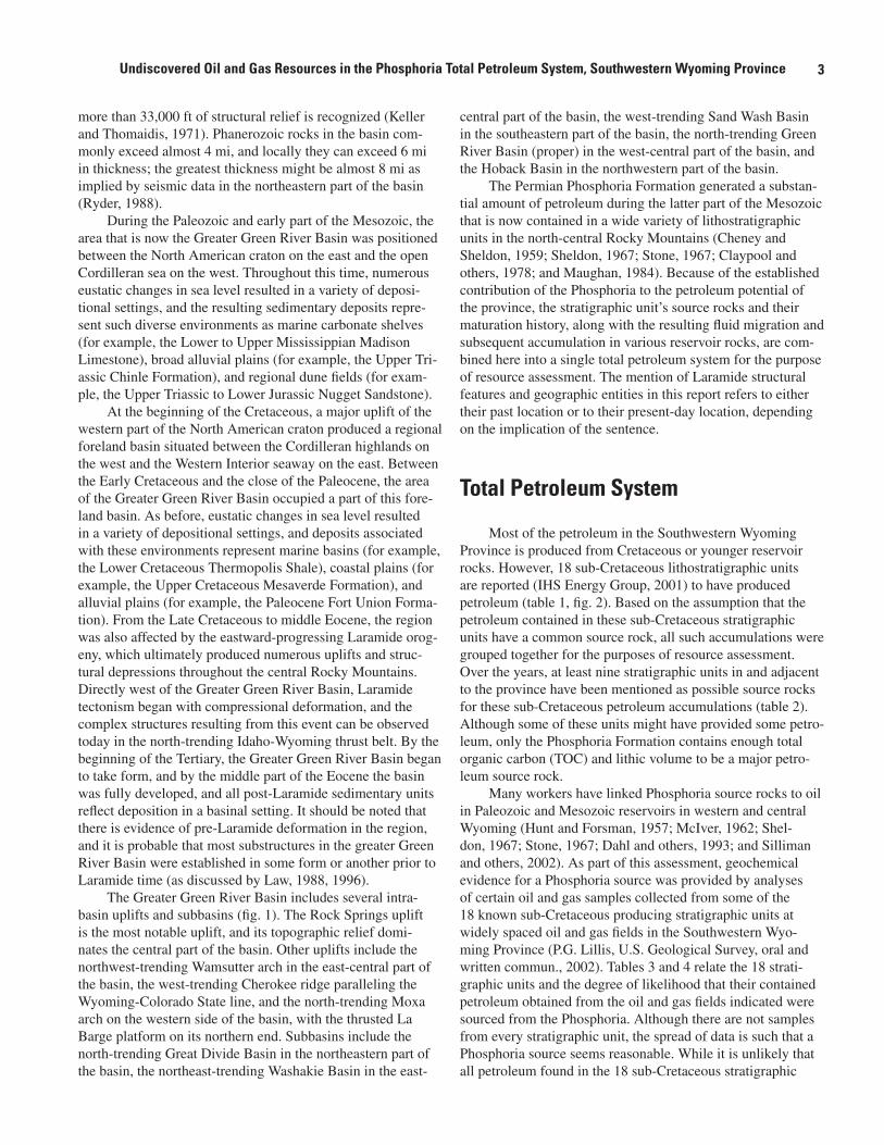
The Permian Phosphoria Formation generated a substan-tial amount of petroleum during the latter part of the Mesozoic that is now contained in a wide variety of lithostratigraphic units in the north-central Rocky Mountains (Cheney and Sheldon, 1959; Sheldon, 1967; Stone, 1967; Claypool and others, 1978; and Maughan, 1984). Because of the established contribution of the Phosphoria to the petroleum potential of the province, the stratigraphic unit’s source rocks and their maturation history, along with the resulting fluid migration and subsequent accumulation in various reservoir rocks, are com-bined here into a single total petroleum system for the purpose of resource assessment. The mention of Laramide structural features and geographic entities in this report refers to either their past location or to their present-day location, depending on the implication of the sentence.
Total Petroleum System
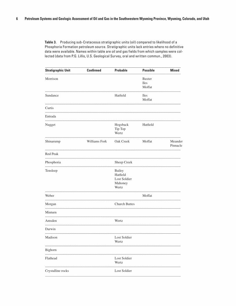
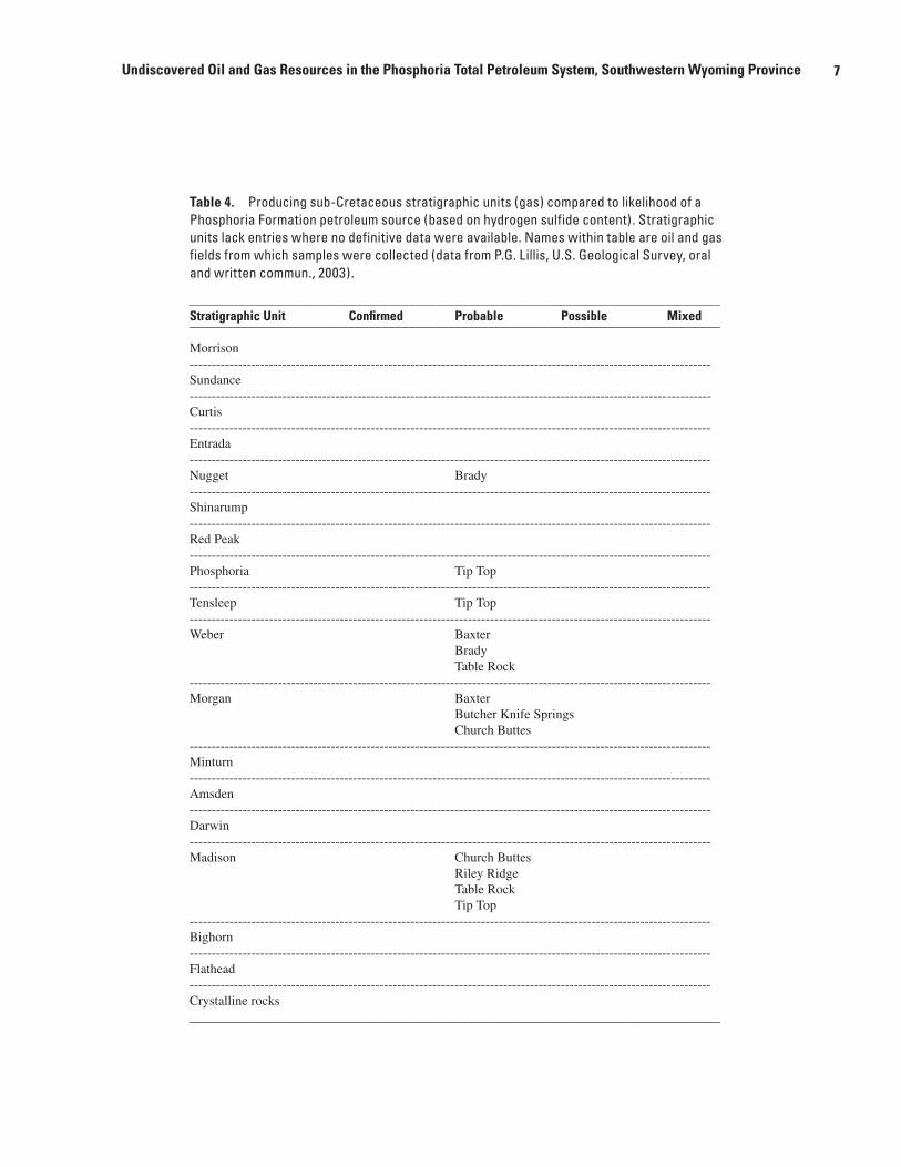
Most of the petroleum in the Southwestern Wyoming Province is produced from Cretaceous or younger reservoir rocks. However, 18 sub-Cretaceous lithostratigraphic units are reported (IHS Energy Group, 2001) to have produced petroleum (table 1, fig. 2). Based on the assumption that the petroleum contained in these sub-Cretaceous stratigraphic units have a common source rock, all such accumulations were grouped together for the purposes of resource assessment. Over the years, at least nine stratigraphic units in and adjacent to the province have been mentioned as possible source rocks for these sub-Cretaceous petroleum accumulations (table 2). Although some of these units might have provided some petro-leum, only the Phosphoria Formation contains enough total organic carbon (TOC) and lithic volume to be a major petro-leum source rock.
Many workers have linked Phosphoria source rocks to oil in Paleozoic and Mesozoic reservoirs in western and central Wyoming (Hunt and Forsman, 1957; McIver, 1962; Shel-don, 1967; Stone, 1967; Dahl and others, 1993; and Silliman and others, 2002). As part of this assessment, geochemical evidence for a Phosphoria source was provided by analyses of certain oil and gas samples collected from some of the 18 known sub-Cretaceous producing stratigraphic units at widely spaced oil and gas fields in the Southwestern Wyo-ming Province (P.G. Lillis, U.S. Geological Survey, oral and written commun., 2002). Tables 3 and 4 relate the 18 strati-graphic units and the degree of likelihood that their contained petroleum obtained from the oil and gas fields indicated were sourced from the Phosphoria. Although there are not samples from every stratigraphic unit, the spread of data is such that a Phosphoria source seems reasonable. While it is unlikely that all petroleum found in the 18 sub-Cretaceous stratigraphic

4 Petroleum Systems and Geologic Assessment of Oil and Gas in the Southwestern Wyoming Province, Wyoming, Colorado, and Utah
Figure 2. Generalized stratigraphic column showing distribution of reservoir rocks in Southwestern Wyoming Province containing oil and gas derived from the Phosphoria Formation (modified from Ryder, 1988).
Maroon Fm.
System
SeriesStage
Eon
Era
Triassic
Permian
Jura
ssic
LU
Mid
dle
Ph
an
ero
zoic
Me
sozo
ic
Pennsylvanian
Mississippian
Devonian
Silurian
Ordovician
Pa
leo
zoic
LM
idd
leU
pp
er
Ca
mb
ria
n
Pre
cam
bri
an
Arc
h.
Pro
ter.
Green River Basin
North and west East and south
Morrison Fm. Morrison Fm. Morrison Fm. Morrison Fm.
Stump
Formation Curtis Fm.
Sundance Fm. Sundance Sundance Fm.
Curtis Fm.Entrada Ss.
FormationPreuss Ss. Entrada Ss.
Twin Creek Ls. Carmel Fm.
Gypsum SpringFormation
Nugget Ss. Nugget Ss. Nugget Ss.
AnkarehFormation
AnkarehFormation
Thaynes Ls.Woodside Fm. Woodside Formation
Weber Ss.
Morgan Fm.
Round Valley Ls.
Dinwoody Fm. Dinwoody Fm. Dinwoody Fm.
Ch
ug
wa
ter
Gp
.
Phosphoriaand
Park CityFormations
Thaynes Ls.
Darby Fm.
Tensleep Ss.
Amsden Fm.
Madison Ls. Madison Ls. Madison Ls.
Darwin Ss. Mbr.
DarbyFormation
Great Divideand
Washakie BasinsSand Wash Basin
Carmel Fm.
Glen CanyonSandstone
Chinle Fm.Shinarump Mbr.
Popo Agie Fm.
Crow Mountain Fm.
Alcova Ls.
Red Peak Fm.
Phosphoria Fm.
Phosphoria Fm.Park City Fm.
Phosphoria Fm.
Phosphoria Fm.Park City Fm.
Phosphoria Fm.
Phosphoria Fm.Park City Fm.
MoenkopiFm.
StateBridge
Fm.
Tensleep Ss.
Weber Ss.
Amsden Fm.
Darwin Ss. Mbr.
MinturnFm.Morgan
Fm. BeldenShale
Doughnut Sh.Humbug Fm.
Leadville Ls.
ChaffeeFormation
Manitou Ls.
Peerless Fm.
Lodore Fm.
Bighorn Dolo.
Gallatin Ls. GallatinLs.
Gros VentreFormation
Gros VentreFormation
Flathead Ss.Flathead Ss.
BuckSpring Fm.
Flathead Ss.
Uinta MountainGroup
Metamorphic and intrusive rocks
? ?
State Bridge Fm.Franson Mbr.
Principal Sub-Cretaceous petroleum source rock
Sub-Cretaceous stratigraphic units with reported petroleum production

5Undiscovered Oil and Gas Resources in the Phosphoria Total Petroleum System, Southwestern Wyoming Province
units is derived from the Phosphoria, there is little geochemi-cal evidence available to prove otherwise. Therefore, in the interest of a complete assessment of the Southwestern Wyo-ming Province, all petroleum in these older rocks is assessed collectively regardless of its actual source.
Although the Phosphoria is the principal source rock under consideration, the unit must be discussed in tandem with the stratigraphically equivalent Lower to Upper Permian Park City Formation because the two units were deposited in adjacent depositional settings and intertongue over much of western and central Wyoming. During the middle part of the Permian a large, relatively shallow, epicontinental embayment was present in what is now southeastern Idaho, southwestern Montana, western and central Wyoming, northwestern Colo-rado, northern Utah, and northeastern Nevada. This embay-ment, called the Sublett Basin (as used by Maughan, 1979), was open to the Cordilleran sea on the west and bordered on the north, east, and south by various continental terrains on the North American craton. The basin had a central part, called the Phosphoria sea (as used by Sheldon, 1963), which was bordered on three sides by a carbonate shelf. Basically, the Phosphoria was deposited in the Phosphoria sea and the Park City was deposited on the carbonate shelf.
McKelvey and others (1959) published the definitive work on the Park City and Phosphoria and recognized (or reconfirmed) six members for the Phosphoria and three mem-bers for the Park City. In ascending order, the Phosphoria members are lower chert member, Meade Peak Phosphatic Shale Member, Rex Chert Member, cherty shale member, Retort Phosphatic Shale Member, and Tosi Chert Member. In ascending order, the Park City members are Grandeur Member, Franson Member, and Ervay Member (McKelvey and others, 1959, fig. 1). All members of the Phosphoria and Park City are Early to Late Permian (late Leonardian through Guadalupian) in age (Wardlaw and Collinson, 1986; Wardlaw, 1995).
As deposition in the Sublett Basin progressed, several eustatic sea-level changes resulted in marine transgressions and regressions, which caused an interfingering of Phosphoria members with Park City members. A good example of this interfingering is in western Wyoming, where an ideal succes-sion of members is, in ascending order, Grandeur (Park City), lower chert—if present (Phosphoria), Meade Peak Phosphatic Shale (Phosphoria), Rex Chert (Phosphoria), Franson (Park City), Retort Phosphatic Shale (Phosphoria), Tosi Chert (Phos-phoria), and Ervay (Park City). In the area of the Southwestern Wyoming Province, the Permian interval (Phosphoria and Park City) unconformably overlies the Middle to Upper Penn-sylvanian Tensleep or Middle Pennsylvanian to Lower Perm-ian Weber Sandstones and is unconformably overlain by the Lower Triassic Dinwoody Formation.
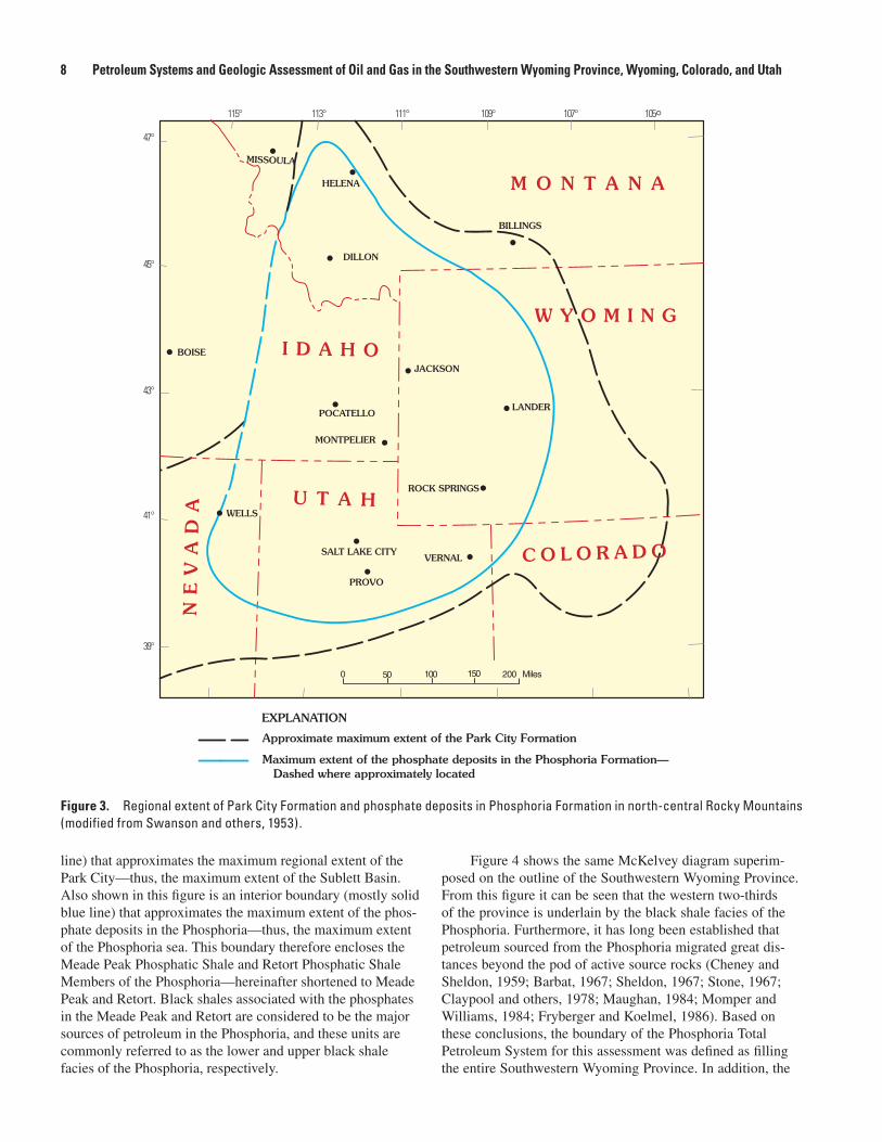
A useful illustration of the extent of Permian rocks in the region is a diagram first published by McKelvey (1949) and subsequently modified and reproduced in numerous publica-tions. Figure 3, a modified version of this diagram (Swanson and others, 1953), shows an outer boundary (black dashed
Table 1. Sub-Cretaceous stratigraphic units known to produce petroleum in the Phosphoria Total Petroleum Sys-tem, Southwestern Wyoming Province, listed by geologic age (IHS Energy Group, 2001).
Table 2. Possible source rocks for sub-Cretaceous petroleum accumulations in the Southwestern Wyoming Province.
Stratigraphic unit Age
Morrison Formation Jurassic
Sundance Formation Jurassic
Curtis Formation Jurassic
Entrada Sandstone Jurassic
Nugget Sandstone Triassic and Jurassic
Shinarump Member* Triassic
Red Peak Formation** Triassic
Phosphoria Formation*** Permian
Tensleep Sandstone Pennsylvanian
Weber Sandstone Pennsylvanian
Morgan Formation Pennsylvanian
Minturn Formation Pennsylvanian
Amsden Formation Pennsylvanian
Darwin Sandstone Member**** Pennsylvanian
Madison Limestone Mississippian
Bighorn Dolomite Ordovician
Flathead Sandstone Cambrian
Crystalline rocks Precambrian
* Shinarump Member of the Chinle Formation.** Included in the Chugwater Group.*** Probably the Park City Formation.****Darwin Sandstone Member of the Amsden Formation.
Stratigraphic unit Age
Twin Creek Limestone Jurassic
Thaynes Limestone Triassic
Phosphoria Formation Permian
Minnelusa Formation Permian-Pennsylvanian
Amsden Formation Pennsylvanian
Belden Shale Pennsylvanian
Madison Limestone Mississippian
Bighorn Dolomite Ordovician
Gallatin Limestone Cambrian
6 Petroleum Systems and Geologic Assessment of Oil and Gas in the Southwestern Wyoming Province, Wyoming, Colorado, and Utah
Table 3. Producing sub-Cretaceous stratigraphic units (oil) compared to likelihood of a Phosphoria Formation petroleum source. Stratigraphic units lack entries where no definitive data were available. Names within table are oil and gas fields from which samples were col-lected (data from P.G. Lillis, U.S. Geological Survey, oral and written commun., 2003).
______________________________________________________________________________Stratigraphic Unit Confirmed Probable Possible Mixed ______________________________________________________________________________
Morrison Baxter Iles Moffat---------------------------------------------------------------------------------------------------------------------Sundance Hatfield Iles Moffat---------------------------------------------------------------------------------------------------------------------Curtis ---------------------------------------------------------------------------------------------------------------------Entrada---------------------------------------------------------------------------------------------------------------------Nugget Hogsback Hatfield Tip Top Wertz---------------------------------------------------------------------------------------------------------------------Shinarump Williams Fork Oak Creek Moffat Meander Pinnacle---------------------------------------------------------------------------------------------------------------------Red Peak ---------------------------------------------------------------------------------------------------------------------Phosphoria Sheep Creek---------------------------------------------------------------------------------------------------------------------Tensleep Bailey Hatfield Lost Soldier Mahoney Wertz---------------------------------------------------------------------------------------------------------------------Weber Moffat---------------------------------------------------------------------------------------------------------------------Morgan Church Buttes---------------------------------------------------------------------------------------------------------------------Minturn ---------------------------------------------------------------------------------------------------------------------Amsden Wertz---------------------------------------------------------------------------------------------------------------------Darwin ---------------------------------------------------------------------------------------------------------------------Madison Lost Soldier Wertz---------------------------------------------------------------------------------------------------------------------Bighorn---------------------------------------------------------------------------------------------------------------------Flathead Lost Soldier Wertz---------------------------------------------------------------------------------------------------------------------Crystalline rocks Lost Soldier______________________________________________________________________________
7Undiscovered Oil and Gas Resources in the Phosphoria Total Petroleum System, Southwestern Wyoming Province
Table 4. Producing sub-Cretaceous stratigraphic units (gas) compared to likelihood of a Phosphoria Formation petroleum source (based on hydrogen sulfide content). Stratigraphic units lack entries where no definitive data were available. Names within table are oil and gas fields from which samples were collected (data from P.G. Lillis, U.S. Geological Survey, oral and written commun., 2003).
________________________________________________________________________________Stratigraphic Unit Confirmed Probable Possible Mixed ________________________________________________________________________________
Morrison----------------------------------------------------------------------------------------------------------------------Sundance ------------------------------------------------------------------------------------------------------------ ----------Curtis----------------------------------------------------------------------------------------------------------------------Entrada ----------------------------------------------------------------------------------------------------------------------Nugget Brady----------------------------------------------------------------------------------------------------------------------Shinarump ----------------------------------------------------------------------------------------------------------------------Red Peak ----------------------------------------------------------------------------------------------------------------------Phosphoria Tip Top----------------------------------------------------------------------------------------------------------------------Tensleep Tip Top----------------------------------------------------------------------------------------------------------------------Weber Baxter Brady Table Rock----------------------------------------------------------------------------------------------------------------------Morgan Baxter Butcher Knife Springs Church Buttes----------------------------------------------------------------------------------------------------------------------Minturn----------------------------------------------------------------------------------------------------------------------Amsden----------------------------------------------------------------------------------------------------------------------Darwin ----------------------------------------------------------------------------------------------------------------------Madison Church Buttes Riley Ridge Table Rock Tip Top----------------------------------------------------------------------------------------------------------------------Bighorn----------------------------------------------------------------------------------------------------------------------Flathead----------------------------------------------------------------------------------------------------------------------Crystalline rocks________________________________________________________________________________
8 Petroleum Systems and Geologic Assessment of Oil and Gas in the Southwestern Wyoming Province, Wyoming, Colorado, and Utah
line) that approximates the maximum regional extent of the Park City—thus, the maximum extent of the Sublett Basin. Also shown in this figure is an interior boundary (mostly solid blue line) that approximates the maximum extent of the phos-phate deposits in the Phosphoria—thus, the maximum extent of the Phosphoria sea. This boundary therefore encloses the Meade Peak Phosphatic Shale and Retort Phosphatic Shale Members of the Phosphoria—hereinafter shortened to Meade Peak and Retort. Black shales associated with the phosphates in the Meade Peak and Retort are considered to be the major sources of petroleum in the Phosphoria, and these units are commonly referred to as the lower and upper black shale facies of the Phosphoria, respectively.
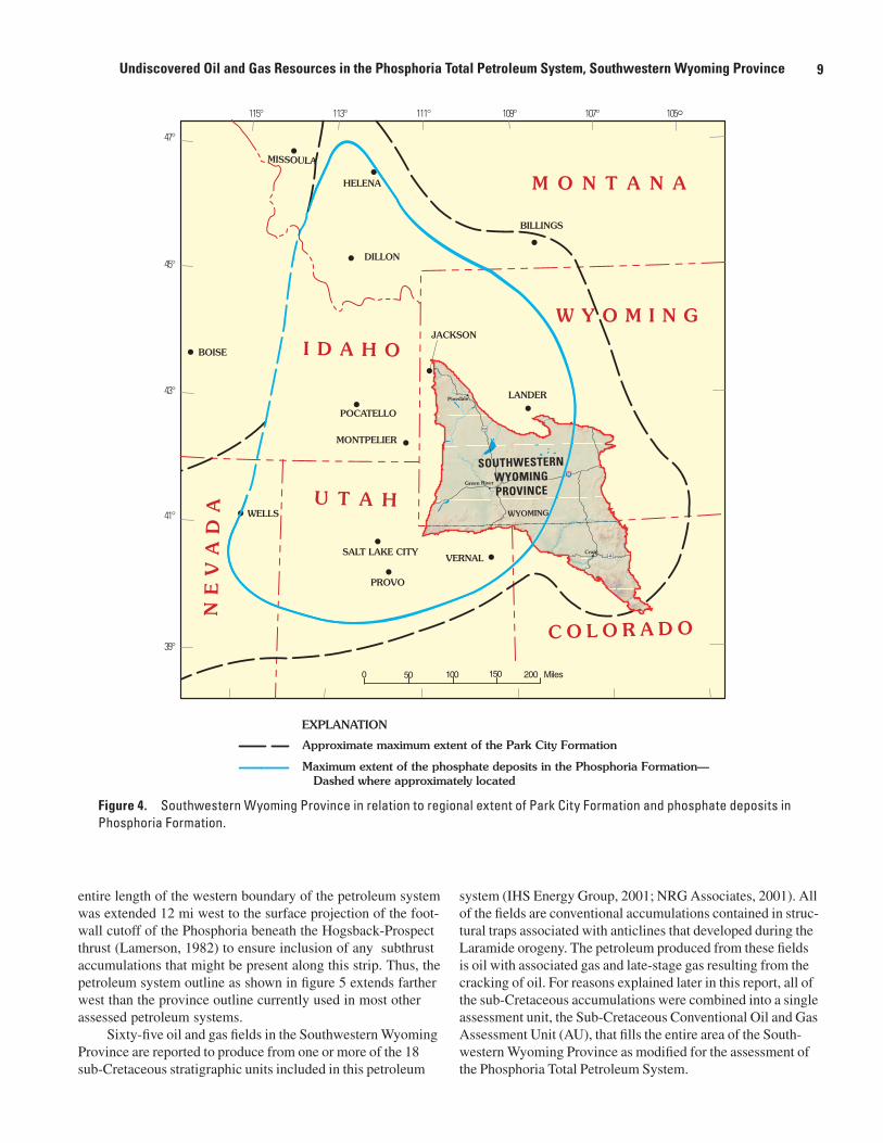
Figure 4 shows the same McKelvey diagram superim-posed on the outline of the Southwestern Wyoming Province. From this figure it can be seen that the western two-thirds of the province is underlain by the black shale facies of the Phosphoria. Furthermore, it has long been established that petroleum sourced from the Phosphoria migrated great dis-tances beyond the pod of active source rocks (Cheney and Sheldon, 1959; Barbat, 1967; Sheldon, 1967; Stone, 1967; Claypool and others, 1978; Maughan, 1984; Momper and Williams, 1984; Fryberger and Koelmel, 1986). Based on these conclusions, the boundary of the Phosphoria Total Petroleum System for this assessment was defined as filling the entire Southwestern Wyoming Province. In addition, the
Figure 3. Regional extent of Park City Formation and phosphate deposits in Phosphoria Formation in north-central Rocky Mountains (modified from Swanson and others, 1953).
Maximum extent of the phosphate deposits in the Phosphoria Formation—Dashed where approximately located
Approximate maximum extent of the Park City Formation
EXPLANATION
M O N T A N A
W Y O M I N G
C O L O R A D O
U T A H
NE
VA
DA
I D A H O
MISSOULA
HELENA
DILLON
BOISE
JACKSON
POCATELLO
MONTPELIER
BILLINGS
LANDER
ROCK SPRINGS
VERNAL
PROVO
SALT LAKE CITY
WELLS�
�
�
�
�
�
�
�
�
�
�
�
�
�
115° 113° 111° 109° 107° 105°47°
45°
43°
41°
39°
0 50 100 150 200 Miles
9Undiscovered Oil and Gas Resources in the Phosphoria Total Petroleum System, Southwestern Wyoming Province
entire length of the western boundary of the petroleum system was extended 12 mi west to the surface projection of the foot-wall cutoff of the Phosphoria beneath the Hogsback-Prospect thrust (Lamerson, 1982) to ensure inclusion of any subthrust accumulations that might be present along this strip. Thus, the petroleum system outline as shown in figure 5 extends farther west than the province outline currently used in most other assessed petroleum systems.
Sixty-five oil and gas fields in the Southwestern Wyoming Province are reported to produce from one or more of the 18 sub-Cretaceous stratigraphic units included in this petroleum
system (IHS Energy Group, 2001; NRG Associates, 2001). All of the fields are conventional accumulations contained in struc-tural traps associated with anticlines that developed during the Laramide orogeny. The petroleum produced from these fields is oil with associated gas and late-stage gas resulting from the cracking of oil. For reasons explained later in this report, all of the sub-Cretaceous accumulations were combined into a single assessment unit, the Sub-Cretaceous Conventional Oil and Gas Assessment Unit (AU), that fills the entire area of the South-western Wyoming Province as modified for the assessment of the Phosphoria Total Petroleum System.
Figure 4. Southwestern Wyoming Province in relation to regional extent of Park City Formation and phosphate deposits in Phosphoria Formation.
M O N T A N A
W Y O M I N G
C O L O R A D O
U T A H
NEVAD
A
I D A H O
MISSOULA
HELENA
DILLON
BOISE
JACKSON
POCATELLO
MONTPELIER
BILLINGS
LANDER
VERNAL
PROVO
SALT LAKE CITY
WELLS�
�
�
�
�
�
�
�
�
�
�
�
�
�
115° 113° 111° 109° 107° 105°47°
45°
43°
41°
39°
0 50 100 150 200 Miles
Maximum extent of the phosphate deposits in the Phosphoria Formation—Dashed where approximately located
Approximate maximum extent of the Park City Formation
EXPLANATION
Summit Daggett
Pinedale
Green River
Rawlins
Craig40
80
WYOMING
191
SOUTHWESTERNWYOMINGPROVINCE

10 Petroleum Systems and Geologic Assessment of Oil and Gas in the Southwestern Wyoming Province, Wyoming, Colorado, and Utah
Figure 5. Isopach map of cumulative thickness (ft) of black shale facies of Phosphoria Formation in Phosphoria Total Petroleum System, Southwestern Wyoming Province (modified after Sheldon, 1967).
100
100
80
80
60
6060
40 20
0
30
Carbon
Grand
Garfield
Fremont
Daggett
Eagle
Jackson
Lincoln
Moffat
Natrona
Rio Blanco
Routt
Sublette
Summit
Sweetwater
Teton
Uinta
UintahDuchesne
110°111° 109° 108° 107°
40°
41°
42°
43°
UTAH
WYOMING
COLORADO
60 Miles0 30
Phosphoria TotalPetroleum Systemboundary
EXPLANATION
Cumulativethickness (feet) ofblack shale facies ofthe PhosphoriaFormation
0

11Undiscovered Oil and Gas Resources in the Phosphoria Total Petroleum System, Southwestern Wyoming Province
Source Rock
The oil-prone source rocks in the Phosphoria Forma-tion are contained in the Meade Peak and Retort members (Maughan, 1984). In southeastern Idaho, where the Meade Peak is well developed, the unit is 125–225 ft thick (McK-elvey and others, 1959) and consists of organic claystone, muddy siltstone, phosphorite, and dolomitic calclithite—in order of decreasing abundance. The claystones and siltstones are thinly laminated and contain most of the organic carbon in the member. Minute quantities of oil are also present in these rocks (Cheney and Sheldon, 1959; Claypool and others, 1978). The phosphorite is mostly wackestone and packstone consist-ing of fine- to medium-grained, spherical to oblate peloids of carbonate fluorapatite. All of these rocks are very dark gray to black on fresh and weathered surfaces. The calclithite is very fine grained and weathers light gray to light brown; the light-brown rocks are typically punky. Sedimentary struc-tures and fossils are not commonly observed in the Meade Peak. Because the Meade Peak is poorly exposed in natural outcrops, the best descriptions of the unit come from the high-walls of phosphate mines. At these locations the unit can be separated into five subdivisions; in ascending order these are lower waste, lower ore, middle waste, upper ore, and upper waste. Most of the claystones and siltstones, and hence the organic carbon, are contained in the waste zones. Regionally, the Meade Peak lies unconformably on the Grandeur Member of the Park City Formation, except where the lower chert member of the Phosphoria is locally present. The depocenter for the Meade Peak, as shown on regional isopach maps, was located in southeastern Idaho and northern Utah (Maughan, 1984).
The Retort is also intrepreted as having generated large amounts of petroleum (Maughan, 1984). This unit contains rocks comparable to those in the Meade Peak, although the proportions differ. Where the Retort is well developed in south-western Montana, the unit is 55–80 ft thick (less than one-half the thickness of the Meade Peak) and can be divided into three parts: lower phosphatic zone, middle calcareous mudstone, and upper phosphatic zone (McKelvey and others, 1959). The Retort is an oil shale at its type locality near Dillon, Montana, and has yielded oil upon distillation (McKelvey and others, 1959; Maughan, 1984). In this area the Retort is thermally immature, but where buried more deeply in west-central Wyo-ming, it is overmature. The depocenter for the Retort was in southwestern Montana, which represents a 68-mi, north-north-west shift from the position of the Meade Peak’s depocenter (Maughan, 1984).
Two previously published maps are of interest to this discussion. Figure 5 shows the cumulative thickness in feet of black-shale facies (meaning Meade Peak and Retort) in the Phosphoria in the Wyoming part of the Southwestern Wyoming Province (Sheldon, 1967), and figure 6 shows the distribution of organic carbon in kilograms per square meter in the Phosphoria in the province (Claypool and others, 1978).
Some obvious discrepancies are noted in comparing figures 3, 5, and 6. This is because the maps were constructed by differ-ent geologists, working at different times, and using different sets of limited data collected in reconnaissance.
In the region of the former Sublett Basin, the Meade Peak and Retort combined have an average maximum TOC of about 10 weight percent, and in the organically richest beds, as much as 30 weight percent (Maughan, 1984). The average TOC in the Meade Peak is 2.4 weight percent based on the analyses of 285 samples collected from 40 localities; the aver-age maximum TOC of 9 weight percent is from the area east of Pocatello, Idaho, near the Wyoming State line. The average TOC in the Retort is 4.9 weight percent (double the average of the Meade Peak) based on the analyses of 82 samples from 22 localities; the average maximum TOC of 10 weight percent is from the area of Dillon, Montana.
Since the Phosphoria was deposited in a marine envi-ronment and because the petroleum initially generated was almost exclusively oil, it is presumed that the rocks originally contained Type-II kerogen. This assumption is supported by analysis of a sample of Retort collected at the member’s type locality in southwest Montana that documents the presence of Type-II kerogen (Lewan, 1985). Furthermore, because Phos-phoria-sourced oil (hereinafter shortened to Phosphoria oil) is relatively high in sulfur, the term Type-IIS is applied to the kerogen.
Maturation
The maturation history of Phosphoria Formation source rocks has been the subject of debate for many years. Geolo-gists have used isopach maps of overburden thickness, thermal burial-history curves based on vitrinite reflectance data, and unique thermal models such as gravity-driven fluid flow. As early as the 1950’s, many geologists (for example, Hanson, 1959) believed that, in general, source rocks were capable of generating oil relatively soon after deposition. In the case of phosphorites, Powell and others (1975) stated that, worldwide, the high proportion of extractable organic matter found in unaltered phosphorites implies that the rocks were capable of generating oil at an early stage of their thermal history. As for the Phosphoria, many workers believe that the type of source rocks contained in the stratigraphic unit were capable of generating oil at lower temperatures (less overburden) than the temperatures required of other types of source rocks. For example, Lewan (1985, 1998) stated that source rocks contain-ing Type-IIS kerogen, such as the Phosphoria, are known to generate oil at abnormally low thermal maturities. But despite this support for an early maturation of Phosphoria source rocks, the most recent evidence indicates that oil generation took place at least 170 Ma after deposition.
Cheney and Sheldon (1959) were among the first work-ers to relate overburden thickness and the resulting increase in temperature of the organic-rich rocks in the Phosphoria

12 Petroleum Systems and Geologic Assessment of Oil and Gas in the Southwestern Wyoming Province, Wyoming, Colorado, and Utah
Figure 6. Distribution of organic carbon (in kilograms per square meter) in black shale facies of Phosphoria Formation in Phosphoria Total Petroleum System, Southwestern Wyoming Province (modified after Claypool and others, 1978).
Carbon
Grand
Garfield
Fremont
Daggett
Eagle
Jackson
Lincoln
Moffat
Natrona
Rio Blanco
Routt
Sublette
Summit
Sweetwater
Teton
Uinta
UintahDuchesne
110°111° 109° 108° 107°
40°
41°
42°
43°
UTAH
WYOMING
COLORADO
0
0
300
600
1,000
2,000
3,000
60 Miles0 30
Phosphoria TotalPetroleum Systemboundary
EXPLANATION
Distribution oforganic carbon(kilograms per squaremile) in blackshale facies of thePhosphoria Formation
0

13Undiscovered Oil and Gas Resources in the Phosphoria Total Petroleum System, Southwestern Wyoming Province
to the generation of oil. They recognized that the Triassic and Jurassic rocks that overlie the Phosphoria are thickest in southeastern Idaho and, from there, thin toward central Wyo-ming. Although not directly stated, they implied that increased temperature related to overburden on Phosphoria source rocks was sufficient by the end of the Triassic to generate oil at the beginning of the Early Jurassic.
Sheldon (1967) expanded on this thickness-of-overburden compared to onset-of-maturation theme by constructing four isopach maps covering western and central Wyoming show-ing the thickness of Phosphoria overburden at the end of the Triassic, at the end of the Jurassic, at the end of the Early Cre-taceous, and at the end of the Late Cretaceous. On the basis of these maps, Sheldon implied that the generation of Phospho-ria-sourced oil commenced soon after the deposition of Trias-sic sediments.
Stone (1967), in a paper published after Sheldon’s 1967 paper, used Sheldon’s isopach maps and applied a threshold overburden thickness of 2,000 ft as the critical depth of burial needed to begin the generation of oil from the source rocks contained in the Phosphoria. On this basis, Stone postulated that oil generation could have started as early as the Late Tri-assic and was completed before the end of the Early Jurassic.
In a major shift in thinking, Claypool and others (1978) concluded that much greater depths of burial were required to raise the temperature of the source rocks in the Phosphoria to the point that oil would be generated. These workers placed the top (beginning) of the oil window (zone of oil generation) equivalent to a burial depth of 6,900 ft, and the bottom (end) of the oil window equivalent to a burial depth of 16,000 ft. However, maximum oil generation took place between burial depths of 8,200 ft and 14,750 ft, with peak generation prob-ably taking place at about 9,800 ft. At depths of burial below the oil window, Phosphoria source rocks now contain almost no organic carbon, and the oil that was originally present has since undergone thermal destruction and the byproducts driven out of the rocks. In the case of source rocks that were not buried deep enough to enter the oil window, these rocks are presently rich in asphaltic compounds and contain an imma-ture assemblage of organic matter that differs from natural petroleum (for example, the oil shales in the Retort in south-western Montana). As summarized by Claypool and others (1978), the source rocks in the Phosphoria are overmature in the Idaho-Wyoming thrust belt, mature in most of the Greater Green River Basin, and immature in southeastern Montana. Claypool and others (1978) stated that maximum burial of Permian rocks was achieved by the end of the Cretaceous. However, in the central parts of some intermontane basins, Tertiary sediments continued to accumulate, and maximum burial might not have taken place until about the middle Eocene. This might have been the case in the Greater Green River Basin with the addition of the Paleocene Fort Union Formation and lower Eocene Wasatch and Green River For-mations. Claypool and others (1978) used Sheldon’s (1967) isopach maps of Mesozoic overburden coupled with their min-imum requirement of 1.3 mi of overburden to decide that oil
was not generated from the Phosphoria anywhere in the region until the Early Cretaceous (substantially later than the Early Jurassic postulated by previous investigators). By inference, this would have taken place in southeastern Idaho, but matura-tion to the east of this area would not have taken place until the Late Cretaceous. Claypool and others (1978) estimated that as much as 225 billion barrels of oil might have ultimately been generated from the source rocks of the Phosphoria.
In a relatively recent paper, Burtner and Nigrini (1994) postulated that processes other than simple depth of burial might have been involved in raising the temperature of the Phosphoria source rocks. Using a model calibrated by apatite-fission-track and organic-maturation data, these work-ers envisioned a scheme whereby cool, meteoric water along the frontal margin of the Idaho-Wyoming thrust belt moved down and eastward into the adjacent foreland sediments. As the water moved eastward away from the highlands, it picked up heat in the deeper part of the foreland basin and eventually moved upward toward the stable platform. As a result, areas of abnormally high heat flow developed under Phosphoria source rocks, causing oil generation earlier than might be expected by depth of burial alone. This process was first manifested in the Early Cretaceous with movement along the Paris-Willard thrust in southeastern Idaho, and then the process shifted incre-mentally eastward in response to each younger thrust move-ment as tectonism progressed in that direction. Following the Paris-Willard event (Early Cretaceous), movement along the Crawford and Meade thrusts adjacent to the Idaho-Wyoming State line (Late Cretaceous) and movement along the Absa-roka thrust in westernmost Wyoming (latest Cretaceous to early Paleocene) set up similar gravity-driven, hydrodynamic systems. In addition to these thrust-related hydrodynamic sys-tems, Burtner and Nigrini (1994) proposed that during Late Jurassic time warm water from the center of the Cordilleran sea moved eastward and increased the surface heat flow in the vicinity of the future Paris-Willard thrust and adjacent areas to the east. As shown in several figures in Burtner and Nigrini’s (1994) report, gravity-driven, hydrodynamic events caused Phosphoria source rocks to go through the oil window in the vicinity of the Idaho-Wyoming thrust belt during the Late Jurassic (Oxfordian) in the vicinity of the Green River Basin during the late Early Cretaceous (Albian) and in the vicinity of the Wind River Range in the middle part of the Late Creta-ceous (Coniacian).
As part of the geologic assessment of the Southwestern Wyoming Province, Pawlewicz and Finn (2002) analyzed vitrinite reflectance in 183 coal samples to establish levels of thermal maturity. All of the samples were from either Cretaceous or Tertiary formations. Almost all of the samples were handpicked from drill cuttings archived in the USGS Core Research Center in Denver, Colorado. Of 23 drill holes sampled, vitrinite data from three holes—Bear 1, Bruff 2, and Eagles Nest—could be used to characterize the thermal matu-ration of Phosphoria source rocks. Using subsurface strati-graphic data from these drill holes, along with similar data from drill holes Wagon Wheel, Federal 31-1, and Adobe Town
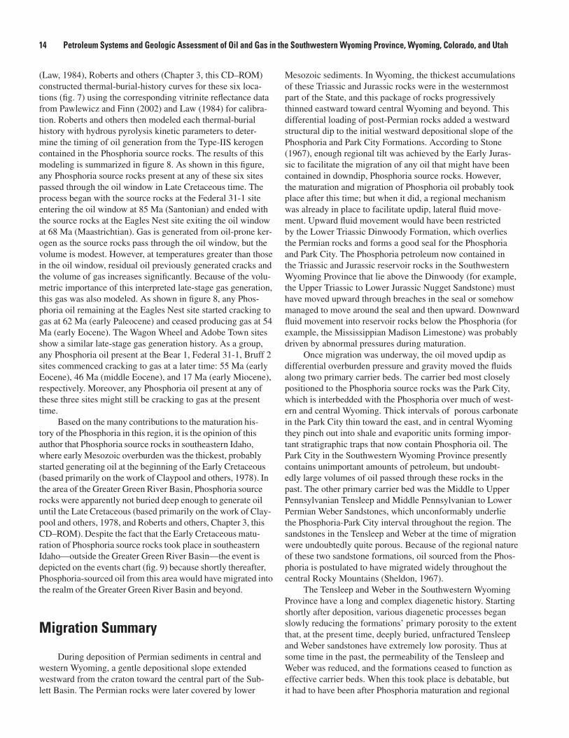
14 Petroleum Systems and Geologic Assessment of Oil and Gas in the Southwestern Wyoming Province, Wyoming, Colorado, and Utah
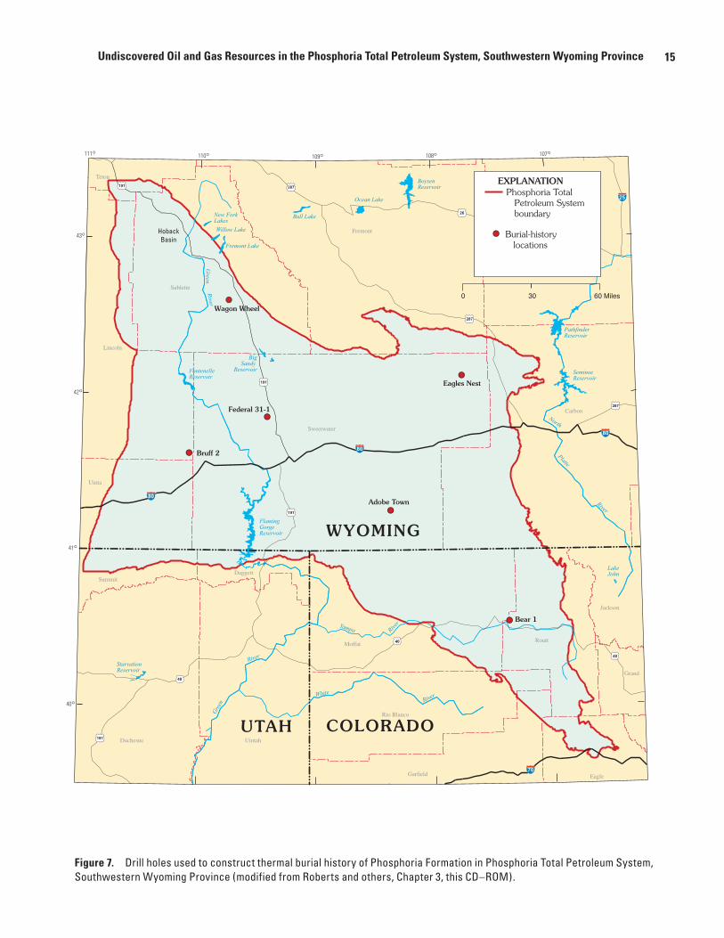
(Law, 1984), Roberts and others (Chapter 3, this CD–ROM) constructed thermal-burial-history curves for these six loca-tions (fig. 7) using the corresponding vitrinite reflectance data from Pawlewicz and Finn (2002) and Law (1984) for calibra-tion. Roberts and others then modeled each thermal-burial history with hydrous pyrolysis kinetic parameters to deter-mine the timing of oil generation from the Type-IIS kerogen contained in the Phosphoria source rocks. The results of this modeling is summarized in figure 8. As shown in this figure, any Phosphoria source rocks present at any of these six sites passed through the oil window in Late Cretaceous time. The process began with the source rocks at the Federal 31-1 site entering the oil window at 85 Ma (Santonian) and ended with the source rocks at the Eagles Nest site exiting the oil window at 68 Ma (Maastrichtian). Gas is generated from oil-prone ker-ogen as the source rocks pass through the oil window, but the volume is modest. However, at temperatures greater than those in the oil window, residual oil previously generated cracks and the volume of gas increases significantly. Because of the volu-metric importance of this interpreted late-stage gas generation, this gas was also modeled. As shown in figure 8, any Phos-phoria oil remaining at the Eagles Nest site started cracking to gas at 62 Ma (early Paleocene) and ceased producing gas at 54 Ma (early Eocene). The Wagon Wheel and Adobe Town sites show a similar late-stage gas generation history. As a group, any Phosphoria oil present at the Bear 1, Federal 31-1, Bruff 2 sites commenced cracking to gas at a later time: 55 Ma (early Eocene), 46 Ma (middle Eocene), and 17 Ma (early Miocene), respectively. Moreover, any Phosphoria oil present at any of these three sites might still be cracking to gas at the present time.
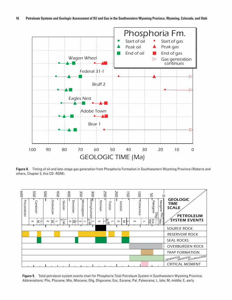
Based on the many contributions to the maturation his-tory of the Phosphoria in this region, it is the opinion of this author that Phosphoria source rocks in southeastern Idaho, where early Mesozoic overburden was the thickest, probably started generating oil at the beginning of the Early Cretaceous (based primarily on the work of Claypool and others, 1978). In the area of the Greater Green River Basin, Phosphoria source rocks were apparently not buried deep enough to generate oil until the Late Cretaceous (based primarily on the work of Clay-pool and others, 1978, and Roberts and others, Chapter 3, this CD–ROM). Despite the fact that the Early Cretaceous matu-ration of Phosphoria source rocks took place in southeastern Idaho—outside the Greater Green River Basin—the event is depicted on the events chart (fig. 9) because shortly thereafter, Phosphoria-sourced oil from this area would have migrated into the realm of the Greater Green River Basin and beyond.
Migration Summary
During deposition of Permian sediments in central and western Wyoming, a gentle depositional slope extended westward from the craton toward the central part of the Sub-lett Basin. The Permian rocks were later covered by lower
Mesozoic sediments. In Wyoming, the thickest accumulations of these Triassic and Jurassic rocks were in the westernmost part of the State, and this package of rocks progressively thinned eastward toward central Wyoming and beyond. This differential loading of post-Permian rocks added a westward structural dip to the initial westward depositional slope of the Phosphoria and Park City Formations. According to Stone (1967), enough regional tilt was achieved by the Early Juras-sic to facilitate the migration of any oil that might have been contained in downdip, Phosphoria source rocks. However, the maturation and migration of Phosphoria oil probably took place after this time; but when it did, a regional mechanism was already in place to facilitate updip, lateral fluid move-ment. Upward fluid movement would have been restricted by the Lower Triassic Dinwoody Formation, which overlies the Permian rocks and forms a good seal for the Phosphoria and Park City. The Phosphoria petroleum now contained in the Triassic and Jurassic reservoir rocks in the Southwestern Wyoming Province that lie above the Dinwoody (for example, the Upper Triassic to Lower Jurassic Nugget Sandstone) must have moved upward through breaches in the seal or somehow managed to move around the seal and then upward. Downward fluid movement into reservoir rocks below the Phosphoria (for example, the Mississippian Madison Limestone) was probably driven by abnormal pressures during maturation.
Once migration was underway, the oil moved updip as differential overburden pressure and gravity moved the fluids along two primary carrier beds. The carrier bed most closely positioned to the Phosphoria source rocks was the Park City, which is interbedded with the Phosphoria over much of west-ern and central Wyoming. Thick intervals of porous carbonate in the Park City thin toward the east, and in central Wyoming they pinch out into shale and evaporitic units forming impor-tant stratigraphic traps that now contain Phosphoria oil. The Park City in the Southwestern Wyoming Province presently contains unimportant amounts of petroleum, but undoubt-edly large volumes of oil passed through these rocks in the past. The other primary carrier bed was the Middle to Upper Pennsylvanian Tensleep and Middle Pennsylvanian to Lower Permian Weber Sandstones, which unconformably underlie the Phosphoria-Park City interval throughout the region. The sandstones in the Tensleep and Weber at the time of migration were undoubtedly quite porous. Because of the regional nature of these two sandstone formations, oil sourced from the Phos-phoria is postulated to have migrated widely throughout the central Rocky Mountains (Sheldon, 1967).
The Tensleep and Weber in the Southwestern Wyoming Province have a long and complex diagenetic history. Starting shortly after deposition, various diagenetic processes began slowly reducing the formations’ primary porosity to the extent that, at the present time, deeply buried, unfractured Tensleep and Weber sandstones have extremely low porosity. Thus at some time in the past, the permeability of the Tensleep and Weber was reduced, and the formations ceased to function as effective carrier beds. When this took place is debatable, but it had to have been after Phosphoria maturation and regional
15Undiscovered Oil and Gas Resources in the Phosphoria Total Petroleum System, Southwestern Wyoming Province
Figure 7. Drill holes used to construct thermal burial history of Phosphoria Formation in Phosphoria Total Petroleum System, Southwestern Wyoming Province (modified from Roberts and others, Chapter 3, this CD–ROM).
Carbon
Grand
Garfield
Fremont
Daggett
Eagle
Jackson
Lincoln
Moffat
Natrona
Rio Blanco
Routt
Sublette
Summit
Sweetwater
Teton
Uinta
UintahDuchesne
HobackBasin
Green
North
Platte
RiverRiver
FlamingGorgeReservoir
PathfinderReservoir
SeminoeReservoir
BoysenReservoir
Ocean Lake
Bull Lake
BigSandy
ReservoirFontenelleReservoir
StarvationReservoir
Green
River
River
River
Fremont Lake
Willow Lake
New ForkLakes
Yampa
White
LakeJohn
80
80
80
70
287
287
40
40
25
26
287
191
191
40
191
191
110°111° 109° 108° 107°
40°
41°
42°
43°
UTAH
WYOMING
COLORADO
Wagon Wheel
Federal 31-1
Bruff 2
Adobe Town
Eagles Nest
Bear 1
60 Miles0 30
Phosphoria TotalPetroleum Systemboundary
EXPLANATION
Burial-historylocations
16 Petroleum Systems and Geologic Assessment of Oil and Gas in the Southwestern Wyoming Province, Wyoming, Colorado, and Utah
Figure 8. Timing of oil and late-stage gas generation from Phosphoria Formation in Southwestern Wyoming Province (Roberts and others, Chapter 3, this CD–ROM).
Figure 9. Total petroleum system events chart for Phosphoria Total Petroleum System in Southwestern Wyoming Province. Abbreviations: Plio, Pliocene; Mio, Miocene; Olig, Oligocene; Eoc, Eocene; Pal, Paleocene; L, late; M, middle; E, early.
100 90 80 70 60 50 40 30 20 10 0
GEOLOGIC TIME (Ma)
Phosphoria Fm.Start of oilPeak oilEnd of oil
Start of gasPeak gas
End of gasGas generationcontinues
Wagon Wheel
Federal 31-1
Bruff 2
Eagles Nest
Adobe Town
Bear 1
0
100
200
300
400
500
600
50
150
250
350
450
550
Paleogene
Cretaceo
us
Jurassic
Triassic
Permian
Precambrian
Cam
brian
Ordovician
Silurian
Devo
nian
E M L E E E E E E EEEM MM M M ML L L L L L L L L
Mississip
pian
Pennsylvan
ian
Neogene
PalEo
cOlig
Mio
Plio
CRITICAL MOMENTGENER
ATION-
TRAP FORMATION
OVERBURDEN ROCK
RESERVOIR ROCK
SEAL ROCKS
SOURCE ROCK
PETROLEUMSYSTEM EVENTS
GEOLOGICTIMESCALE
ACCUMULATIO
NMIGRA
TION-
17Undiscovered Oil and Gas Resources in the Phosphoria Total Petroleum System, Southwestern Wyoming Province
migration, and before Laramide fracturing allowed oil to remigrate into the by-then brittle Tensleep and Weber sand-stones and other sub-Cretaceous reservoir rocks in the anticli-nal structures. In any case, by the end of the Late Cretaceous, Laramide structures greatly disrupted the regional continuity of the carrier beds, and by the close of the Paleocene, long- distance migration of Phosphoria oil had all but ceased.
Because it is generally accepted that initial oil migra-tion takes place more or less concurrently with maturation, early workers commonly tied the timing of oil migration from Phosphoria source rocks directly to their postulated maturation history. Cheney and Sheldon (1959) stated that the migration of Phosphoria oil took place before the Laramide orogeny, and they implied that the process commenced at the beginning of the Early Jurassic. Based on a series of overburden isopach maps, Sheldon (1967) concluded that migration of Phosphoria oil commenced soon after the deposition of Triassic sediments and ceased after the formation of Laramide structures because no post-Laramide structures are known to contain Phosphoria oil. Sheldon also stated that migration distances might have been as great as several hundred miles.
Stone (1967), bracketed the time of migration of Phos-phoria oil between the Late Triassic and the Early Jurassic. Stone, whose report focused on the Bighorn Basin of central Wyoming, realized that if the oil was generated during this timeframe, but did not accumulate in Laramide anticlinal structures until the Late Cretaceous, about 100 million years of “lost time” had to be accounted for. To explain this enigma, Stone postulated early stratigraphic entrapment as Phosphoria oil moving eastward through the porous carbonates of the Park City was temporarily impeded as the rocks pinched out into the nonporous evaporites of the Permian and Triassic Goose Egg Formation. In addition, some oil might have been tempo-rarily trapped in the upper part of the Tensleep within irregu-larities beneath the Phosphoria-Tensleep unconformity. Later, during the Laramide orogeny, this oil remigrated by way of faults and fractures into the anticlinal structures that now form the petroleum traps in the region.
Claypool and others (1978) implied that migration of Phosphoria oil took place shortly after maturation; that is, between the Early Cretaceous and the pre-Laramide part of the Late Cretaceous—substantially later than the Early Juras-sic postulated by most previous investigators. They also stated that migration distances might have been as great as 250 miles.
By inference, Burtner and Nigrini (1994) thought that Phosphoria oil began migrating away from the vicinity of the Idaho-Wyoming thrust belt in the Late Jurassic, away from the vicinity of the Greater Green River Basin in the late Early Cre-taceous, and away from the vicinity of the Wind River Range in the middle part of the Late Cretaceous.
Assuming that oil begins migrating away from its source rock more or less concurrently with maturation, the work of Roberts and others (Chapter 3, this CD–ROM) calls for Phos-phoria oil in the Southwestern Wyoming Province to begin migrating in the Late Cretaceous. Late-stage gas derived from
the cracking of Phosphoria oil began migrating in early Paleo-cene and locally continues to the present in their model.
Based on the maturation history of the Phosphoria previ-ously discussed, it is the opinion of this author that Phosphoria oil began migrating out of southeastern Idaho at the beginning of the Early Cretaceous. Thus began a 77-million-year period of regional migration, and at a rate 25 to 76 km per one mil-lion years (McDowell, 1975), Phosphoria oil was dispersed throughout the central Rocky Mountains. In areas adjacent to southeastern Idaho that contained Phosphoria source rocks, migration commenced later in the Cretaceous, and in the case of the Southwestern Wyoming Province, Phosphoria oil did not begin migrating until the Late Cretaceous. Most regional migration ceased at the end of the Cretaceous when Laramide tectonism disrupted the system of carrier beds, and Phospho-ria oil was essentially locked into its structurally bounded domains. However, in the case of the Southwestern Wyoming Province—and probably many other areas— deeply buried Phosphoria oil started cracking to gas in the early Paleocene, and a period of late-stage gas migration began that, locally, continues to the present. Most likely, gas migration distances were relatively short and limited to the structurally bounded domains of the oil. It is even possible that in some cases this late-stage gas never left the confines of the structural trap that contained the predecessor oil.
The key factor in a source rock entering and passing through the oil window is the rise in temperature associated with increasing depth of burial. Evidence indicates that post-Permian overburden reached the threshold thickness necessary to initiate the generation of oil from Phosphoria source rocks in the Idaho-Wyoming thrust belt at the beginning of the Early Cretaceous and in the Southwestern Wyoming Province during the Late Cretaceous. However, sub-Cretaceous stratigraphic traps are essentially unknown in the province, and prior to the Laramide orogeny in the latest Cretaceous, there were no sig-nificant structural traps to retain the Phosphoria oil migrating out of the thrust belt or Phosphoria oil generated within the province. Therefore, the oil remained disseminated in carrier beds such as the Park City and Tensleep and migrated slowly updip toward the east. During the Laramide, newly formed anticlines provided structural traps in the area of the province, and Phosphoria oil in the process of migrating through the area from the thrust belt, or Phosphoria oil being generated within the province, accumulated in these structures in significant quantities to form oil fields.
Initially, almost all of these anticlinal structures contained oil, but some structures, especially in the western and central parts of the Southwestern Wyoming Province, now produce large quantities of gas, which is presumed to be late-stage gas derived from thermally altered oil. The key factor in cracking oil to gas is a rise in temperature associated with increasing depth of burial. In the case of the early Phosphoria oil dis-seminated in the province prior to the Laramide orogeny, it is unknown if any oil was buried deep enough to crack to gas, but even if some gas was generated, no significant traps were

18 Petroleum Systems and Geologic Assessment of Oil and Gas in the Southwestern Wyoming Province, Wyoming, Colorado, and Utah
available to concentrate significant quantities. However, two theories are proposed here to explain the Phosphoria-sourced gas currently being produced from some Laramide structures in the province. First, several Laramide structures are docu-mented as showing evidence of pre-Laramide deformation—or at least deformation prior to the main pulse of Laramide tec-tonism. Examples include the Moxa arch in the western part of the province (Wach, 1977), the Rock Springs uplift in the central part of the province (Kirschbaum and Nelson, 1988), and the Lost Soldier anticline in the northeastern part of the province (Reynolds, 1976). If any anticlinal closure developed in these incipient structures, early Phosphoria oil might have accumulated, and if these structures and their contained oil were subsequently covered by younger Cretaceous sediments, perhaps burial was deep enough to raise the temperature to such a degree that the oil cracked to gas. Second, according to Claypool and others (1978), the maximum depth of burial in the central parts of some Rocky Mountain intermontane basins was not reached until the middle Eocene. Therefore, in these areas any oil contained in Laramide structures might have been buried beneath volumes of Tertiary deposits significant to raise the temperature to the degree that oil was cracked to gas.
Reservoir Rocks
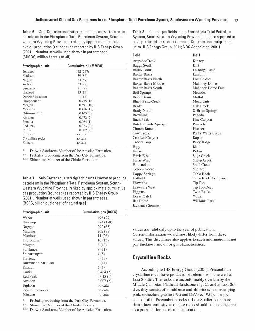
According to IHS Energy Group (2001), petroleum is produced from 18 sub-Cretaceous lithostratigraphic units in the Southwestern Wyoming Province (table 1). But by listing the units in order of decreasing number of producing wells, it is apparent that some stratigraphic units are more prominent than others in terms of exploration and production activity (table 5). For example, the Tensleep Sandstone produces from 265 of the total 697 sub-Cretaceous wells in the province; thus, about 38 percent of the wells are producing from just one stratigraphic unit. Adding the next four units—Sundance Formation, Nugget Sandstone, Madison Limestone, and Mor-rison Formation—about 79 percent of the wells are producing from only 5 of the 18 stratigraphic units. The stratigraphic units listed in table 5 can be categorized into three groups based on natural breaks in the numbers of producing wells. The first group contains the five primary stratigraphic units whose producing wells range from 42 to 265 in number; these stratigraphic units are discussed in more detail than the others in this report. The next group contains the five secondary stratigraphic units whose producing wells range from 21 to 28. The last group contains the eight stratigraphic units whose producing wells range from 1 to 8.
Tables 6 and 7 show the 18 stratigraphic units listed by decreasing cumulative production of oil or gas, respectively, as reported by IHS Energy Group (2001), and this information provides two additional rankings of the stratigraphic units. While the listings in tables 5, 6, and 7 are similar, there are some notable differences. For example, the Sundance is listed second in number of producing wells but only fifth in regard to
cumulative oil production. Similarly, the Weber is listed sev-enth in number of producing wells (table 5) but tops the list in regard to cumulative gas production (table 7).
In the following discussions, references are frequently made to published descriptions of the stratigraphic units at specific oil and gas fields (commonly referred to by their given names). Table 8 lists the 65 oil and gas fields in the province that have produced from one or more sub-Cretaceous strati-graphic units, and their locations are shown in figure 10. In addition to field descriptions, reference is commonly made to information interpreted from the electric logs of one or more widely spaced drill holes that served as stratigraphic anchor points (SAP) in this assessment. The locations of these seven drill holes are also shown in figure 10.
In this report, no distinction is made between wells that are currently producing and wells that have produced in the past but are not currently producing. Similarly, no distinction is made between existing fields and fields that are abandoned.
Published porosity and permeability values can be expressed in various ways (for example, as a single average value, as a range of values, or undesignated), and the values are commonly annotated as to sample type (for example, cuttings or core) and number of samples measured. In addition, many porosity and permeability values were determined from geo-physical logs. Unfortunately, the type of porosity—intergranular or fracture—is rarely noted. Because it would be cumbersome to insert this information in this report, the reader is directed to the original source for specific details. Furthermore, all reported
Table 5. Sub-Cretaceous stratigraphic units known to pro-duce petroleum in the Phosphoria Total Petroleum System, Southwestern Wyoming Province, grouped by greatest to least number of reported producing wells (IHS Energy Group, 2001).________________________________________________________Stratigraphic unit Wells Fields_______________________________________________________________Tensleep Sandstone 265 12Sundance Formation 94 11Nugget Sandstone 80 24 Madison Limestone 73 6Morrison Formation 42 16
Darwin Sandstone* 28 2Weber Sandstone 25 7Phosphoria Formation** 23 10Shinarump Member*** 20 9Flathead Sandstone 21 2
Morgan Formation 8 4Entrada Sandstone 7 5Curtis Formation 4 1Amsden Formation 3 2Crystalline rocks 1 1Red Peak Formation**** 1 1Minturn Formation 1 1Bighorn Dolomite 1 1 _____ Total 697________________________________________________________ * Darwin Sandstone Member of the Amsden Formation.** Probably producing from the Park City Formation.*** Shinarump Member of the Chinle Formation.****Included in the Chugwater Group.
19Undiscovered Oil and Gas Resources in the Phosphoria Total Petroleum System, Southwestern Wyoming Province
values are valid only up to the year of publication. Current information would most likely differ from these values. This disclaimer also applies to such information as net pay thickness and oil or gas characteristics.
Crystalline Rocks
According to IHS Energy Group (2001), Precambrian crystalline rocks have produced petroleum from one well at Lost Soldier. The rocks are unconformably overlain by the Middle Cambrian Flathead Sandstone (fig. 2), and at Lost Sol-dier, they consist of hornblende and chlorite schists overlying pink, orthoclase granite (Pott and DeVore, 1951). The pres-ence of oil in Precambrian rocks at Lost Soldier is no more than a local curiosity, and these rocks should not be considered as a potential for petroleum exploration.
Table 6. Sub-Cretaceous stratigraphic units known to produce petroleum in the Phosphoria Total Petroleum System, South-western Wyoming Province, ranked by approximate cumula-tive oil production (rounded) as reported by IHS Energy Group (2001). Number of wells used shown in parentheses. [MMBO, million barrels of oil]________________________________________________________ Stratigraphic unit Cumulative oil (MMBO)________________________________________________________Tensleep 142 (247)Madison 39 (86)Nugget 34 (59)Weber 33 (22)Sundance 21 (9)Flathead 13 (13)Darwin*-Madison 1 (14)Phosphoria** 0.755 (16)Morgan 0.591 (10)Morrison 0.416 (15)Shinarump*** 0.103 (8)Amsden 0.072 (2)Entrada 0.064 (1)Red Peak 0.023 (2)Curtis 0.002 (2)Bighorn no dataCrystalline rocks no dataMinturn no data_____________________________________________________________
* Darwin Sandstone Member of the Amsden Formation.** Probably producing from the Park City Formation.*** Shinarump Member of the Chinle Formation.
Table 7. Sub-Cretaceous stratigraphic units known to produce petroleum in the Phosphoria Total Petroleum System, South-western Wyoming Province, ranked by approximate cumulative gas production (rounded) as reported by IHS Energy Group (2001). Number of wells used shown in parentheses. [BCFG, billion cubic feet of natural gas] _______________________________________________________Stratigraphic unit Cumulative gas (BCFG)_______________________________________________________Weber 496 (22)Tensleep 384 (189)Nugget 292 (65)Madison 262 (88)Morrison 11 (26)Phosphoria* 10 (13)Morgan 8 (10)Sundance 7 (11)Shinarump** 4 (5)Flathead 3 (13)Darwin***-Madison 2 (14)Entrada 2 (1)Curtis 0.464 (2)Red Peak 0.015 (1)Amsden 0.007 (2)Bighorn no dataCrystalline rocks no dataMinturn no data_______________________________________________________* Probably producing from the Park City Formation. ** Shinarump Member of the Chinle Formation.*** Darwin Sandstone Member of the Amsden Formation.
Table 8. Oil and gas fields in the Phosphoria Total Petroleum System, Southwestern Wyoming Province, that are reported to have produced petroleum from sub-Cretaceous stratigraphic units (IHS Energy Group, 2001; NRG Associates, 2001)._______________________________________________________Field Field_______________________________________________________Arapaho Creek KinneyBaggs South KirkBailey Dome La Barge DeepBaxter Basin LamontBaxter Basin North Lost SoldierBaxter Basin Middle Mahoney DomeBaxter Basin South Mahoney Dome EastBell Springs MeanderBison Basin MoffatBlack Butte Creek Moxa Unit Brady Oak CreekBrady North O’Brien SpringsBrowning Pagoda Buck Peak Pine CanyonButcher Knife Springs Pinnacle Church Buttes PioneerCow Creek Pretty Water CreekCrooked Canyon RaptorCrooks Gap Riley RidgeEspy RimFerris RobinFerris East Sage CreekFerris West Sheep CreekFontenelle Shell CreekGolden Goose SherardHappy Springs Table Rock Hatfield Table Rock SouthwestHiawatha Tip TopHiawatha West Tip Top DeepHiggins Twin RocksHorse Gulch WertzIles Dome Williams ForkJackknife Springs _______________________________________________________

20 Petroleum Systems and Geologic Assessment of Oil and Gas in the Southwestern Wyoming Province, Wyoming, Colorado, and Utah
Figure 10. Oil and gas fields in Phosphoria Total Petroleum System, Southwestern Wyoming Province with reported sub-Cretaceous production (IHS Energy Group, 2001; NRG Associates, 2001), and locations of stratigraphic anchor points referred to in text.
Carbon
Grand
Garfield
Fremont
Daggett
Eagle
Jackson
Lincoln
Moffat
Natrona
Rio Blanco
Routt
Sublette
Summit
Sweetwater
Teton
Uinta
UintahDuchesne
Green
North
Platte
River
River
FlamingGorgeReservoir
PathfinderReservoir
SeminoeReservoir
BoysenReservoir
Ocean Lake
Bull Lake
BigSandy
ReservoirFontenelleReservoir
StarvationReservoir
Green
River
River
River
Fremont Lake
Willow Lake
New ForkLakes
Yampa
White
LakeJohn
80
80
80
70
287
287
287
40
191
191
191
191
40
40
25
26
Arapaho Creek
Baggs South
Baxter Basin South
Bell Springs
Bison Basin
BlackButte Creek
Browning
Buck Peak
ButcherKnife Springs
ChurchButtes Cow
Creek
CrooksGap
Espy
Greater Ferris
Golden GooseHappySprings
Hiawatha
HiawathaWest
HigginsBrady
Jackknife Springs
Kinney
Kirk
Lamont
Lost Soldier
Meander
MoxaUnit
OakCreek
O'BrienSprings
Pagoda
Pine Canyon
Pinnacle
Pioneer
Pretty WaterCreek
Raptor
Riley Ridge
Big Piney-La Barge area
La BargeDeep
RimRobin
Sheep Creek
Shell Creek
Sherard
Table Rock area
Tip Top
Fontenelle
Tip TopDeep
Twin Rocks
Williams Fork
Baxter Basin Middle
Baxter Basin NBaxter BasinCrooked Canyon
Iles Dome
Hatfield
Moffat Horse Gulch Sage Creek
BaileyDome
GreaterMahoneyDome
Wertz
110°111° 109° 108° 107°
40°
41°
42°
43°
WY
UT CO
Key to stratigraphicanchor points
1. 22-19 sec. 19, T. 28 N., R. 113 W. Mobil2. 4 UPRR sec. 11, T. 19 N., R. 104 W. Supply3. Table Rock 21 sec. 21, T. 18 N., R 98 W. Texaco4. Cow Creek 3-12 sec. 12, T. 16 N., R. 92 W. Samedan5. Government 1 sec. 13, T. 2. N., R. 87 W. Humble6. C-68 sec. 10, T. 25 N., R. 90 W. Sinclair7. Hiwatha Deep 1 sec. 22, T. 12 N., R. 100 W. Wexpro
1
2 34
6
7
5
60 Miles0 30
Phosphoria TotalPetroleum Systemboundary
Production cells( 1
containing one or moreoil or gas wells(not drawn to scale)
EXPLANATION
4 square mile)
21Undiscovered Oil and Gas Resources in the Phosphoria Total Petroleum System, Southwestern Wyoming Province
Flathead Sandstone
The Flathead Sandstone is ranked tenth in terms of the number of producing sub-Cretaceous oil and gas wells in the Southwestern Wyoming Province and is positioned last in the group of five secondary sub-Cretaceous stratigraphic units (table 5). Krampert (1949) and other early workers simply used the term “Cambrian beds” when describing rocks produc-ing petroleum at this stratigraphic level, and in some cases, “Cambrian” is designated in the IHS Energy Group (2001) database. However, in the area of the Southwestern Wyoming Province only the Flathead produces petroleum at this level; thus, Cambrian and Flathead have been combined for this assessment. The Flathead unconformably overlies Precam-brian crystalline rocks and is conformably overlain by the Middle Cambrian Gros Ventre and Buck Spring Formations (fig. 2). According to IHS Energy Group (2001), the Flathead has produced petroleum from 21 wells in 2 oil and gas fields. All of the wells are located in the Lost Soldier area with 18 wells at Lost Soldier and 3 wells at Wertz.
The Flathead is 481 ft thick where measured by Berry (1960) on the east flank of the Rawlins uplift, and 165 to 220 ft thick in the subsurface at Lost Soldier (Pott and DeVore, 1951). Regionally, the Flathead is 360 ft thick at SAP 2 and 395 ft thick at SAP 6 (fig. 10). Along the east flank of the Rawlins uplift and in the subsurface at Lost Soldier, the Flat-head consists of a medium- to coarse-grained sandstone, with a quartz-pebble conglomerate in the lowermost part of the formation (Pott and DeVore, 1951; Berry, 1960).
At Lost Soldier, producing sandstones in the Flathead have a reported porosity of 5.4 percent and a permeability of 0.6 mD (Miller, 1992). The reported average pay of produc-ing sandstones is 185 ft. Oil from the Flathead at Lost Soldier is reported to be black and to have an API gravity of 35.2o, a sulfur content of 1.23 percent, and a pour point below 5oF.
Bighorn Dolomite
The Upper Ordovician Bighorn Dolomite unconformably overlies the Upper Cambrian Gallatin Limestone and is uncon-formably overlain by the Devonian Darby Formation (fig. 2). According to IHS Energy Group (2001), the Bighorn has produced petroleum from one well at Fontenelle at the north end of the Moxa arch. The nearest description of the Bighorn in the subsurface is from the Whitney Canyon–Carter Creek oil and gas field about 60 mi southwest of Fontenelle in the Idaho-Wyoming thrust belt (Hoffman and Balcells-Baldwin, 1982; Mullen and Doelger, 1993). At Whitney Canyon–Carter Creek, the Bighorn is a massive, limey dolomite with minor shale interbeds. Producing carbonates in the Bighorn have a reported porosity of 5.6 percent, with a range of 2–8 per-cent. The reported average pay is 40 ft from two zones in the upper 250 ft of the formation, and the gas produced from the Bighorn is reported to have a hydrogen sulfide content of 1.0 percent.
Madison Limestone
The Madison Limestone is ranked fourth in terms of the number of producing sub-Cretaceous oil and gas wells in the Southwestern Wyoming Province (table 5), and is ranked fourth in cumulative gas production (table 7). The Madison uncon-formably overlies the Darby Formation, or the Gros Ventre Formation, Buck Spring Formation, or Flathead Sandstone, and is unconformably overlain by the Darwin Sandstone Member of the Upper Mississippian to Lower Pennsylvanian Amsden Formation, the main body of the Amsden, or the Lower Penn-sylvanian Round Valley Limestone (fig. 2). According to IHS Energy Group (2001), the Madison produces petroleum from 73 wells at 6 oil and gas fields. The largest concentration of Madison wells, 86 percent of total, is located in the Lost Soldier area, with 36 wells at Lost Soldier and 27 wells at Wertz. A much smaller area of Madison wells is located on the southeast-ern flank of the Rock Springs uplift where Table Rock has five wells. The remaining wells are located on the Moxa arch where Riley Ridge has three wells and Raptor and Church Buttes have one well each.
The Madison was deposited on a carbonate shelf along the western edge of the North American craton. Where exposed at the north end of the Rawlins uplift, the Madison is at least 215 ft thick (Berry, 1960). Thickness values of the Madison in the subsurface at individual fields are lacking, but in the central part of the province (SAP 2, 3, 4, and 7) the formation ranges from 310 to 410 ft thick, and the unit seems to thicken toward the north with thickness of 800 ft at SAP 1 and 620 ft at SAP 6 (fig. 10). In the Southwestern Wyoming Province, the formation contains both limestones and dolo-mites (Miller, 1992). This difference in carbonate lithofacies is evidently the result of episodic transgressive and regres-sive events controlled by fluctuations in sea level (Edman and Surdam, 1984). In general, the limestones have very low porosity and the dolomites are porous (Berry, 1960; Edman and Surdam, 1984). In the Lost Soldier area, the Madison is informally subdivided into three zones—A, B, and C—in descending order (Miller, 1992). The A zone is eroded and karstic, and in some places small paleovalleys are filled with the overlying Darwin Sandstone Member. The B zone is pre-dominantly nonporous limestones that separate the A zone from highly fractured and porous C zone dolomites.
At Lost Soldier, the reported porosity of producing car-bonates in the Madison is 10 percent and the permeability is 8 mD; at Wertz the porosity is 11.7 percent and the perme-ability is 15 mD; and at Table Rock, the porosity is 13 percent. (Miller, 1992). The diagenetic history of the Madison at the northern end of the Moxa arch and its effect on porosity and permeability are discussed by Edman and Surdam (1984). In general, the Madison produces oil in the eastern part of the province and gas in the central and western parts of the prov-ince. At Lost Soldier, the average pay of producing carbonates is 162 ft, and the produced oil has an API gravity of 35.6o, a pour point of 5oF, a sulfur content of 1.22 percent, and the oil is brownish black (Miller, 1992). At Wertz, the average
22 Petroleum Systems and Geologic Assessment of Oil and Gas in the Southwestern Wyoming Province, Wyoming, Colorado, and Utah
pay is 205 ft, the produced oil has an API gravity of 35o, the pour point is 5oF, the sulfur content is 1.17 percent, and the oil is greenish black. In the Lost Soldier area, the Madison and Darwin are commonly produced together and the two reser-voirs are considered as one. At Table Rock, the average pay is 160 ft.
Darwin Sandstone Member
The Darwin Sandstone Member of the Amsden Forma-tion is ranked sixth in terms of the number of producing sub-Cretaceous oil and gas wells in the Southwestern Wyoming Province and is positioned first in the group of five secondary sub-Cretaceous stratigraphic units (table 5). The Darwin, positioned in the lowermost part of the Amsden, unconform-ably overlies the Madison Limestone and is unconformably overlain by the main body of the Amsden (fig. 2). According to IHS Energy Group (2001), the Darwin produces petroleum from 28 wells at 2 oil and gas fields. All of the wells are located in the Lost Soldier area with 16 wells at Lost Soldier and 12 wells at Wertz.
At Lost Soldier, the lowest part of the Darwin is thought to be a fluvial unit deposited on an eroded and karstic Madison surface, and the remainder of the member is considered to be a nearshore-marine deposit (Miller, 1992). The Darwin is 46 ft thick where measured by Berry (1960) in the vicinity of the Rawlins uplift, 85–95 ft thick in the subsurface at Lost Sol-dier (Pott and DeVore, 1951), and 108 ft thick at SAP 6 (fig. 10). Where exposed along the flanks of the Rawlins uplift, the Darwin consists of red to brown, dense to soft, fine- to medium-grained sandstone (Berry, 1960). A conglomerate containing pebbles to boulders of limestone and quartzite in a sandstone matrix is present in the lower 20–30 ft of the member. In the subsurface at Lost Soldier, the top few feet of the Darwin is composed of light-green, shaly, fine-grained sandstone; the remainder of the member consists of fine- to medium-grained, poorly sorted sandstone that is typically cross stratified (Pott and DeVore, 1951).
At Lost Soldier, producing sandstones in the Darwin have a reported porosity of 10 percent and a permeability of 8 mD, and at Wertz, the sandstones have a porosity of 13 percent and a permeability of 36 mD (Miller, 1992). The reported aver-age pay of producing sandstones at Lost Soldier is 73 ft, and at Wertz the average is 205 ft. At Lost Soldier, oil from the Darwin is reported to have an API gravity of 35.6o, a sulfur content of 1.22 percent, a pour point below 5oF, and to be brownish black; at Wertz, the oil has an API gravity of 35o, a sulfur content of 1.17 percent, a pour point below 5oF, and is greenish black. At Lost Soldier and Wertz, the Darwin is tradi-tionally produced with the Madison, and the two reservoirs are considered as one.
Amsden Formation
The main body of the Amsden unconformably overlies the Darwin Sandstone Member of the Amsden and is uncon-formably overlain by the Tensleep Sandstone (fig. 2). Accord-ing to IHS Energy Group (2001), the Amsden has produced petroleum from two wells at Wertz and one well at Lost Sol-dier. Where measured by Berry (1960) at the Rawlins uplift, the main body of the Amsden is 204 ft thick and is composed of red, sandy shales with interbedded gray limestone in the lower part of the unit. No information on Amsden petroleum production at either Lost Soldier or Wertz was found. It is pos-sible that this reported production is actually from the Darwin Sandstone Member but was reported as simply Amsden.
Minturn Formation
The Pennsylvanian Minturn Formation conformably overlies the Pennsylvanian Belden Shale and is conformably overlain by the Pennsylvanian Maroon Formation (fig. 2). According to IHS Energy Group (2001), the Minturn has produced petroleum from one well at Moffat in the Sand Wash Basin. As generally described, the Minturn in north-western Colorado is more than 1,000 ft thick and consists of sandstone, conglomerate, and shale (Tweto, 1981). The closest Minturn exposures to Moffat are about 17 mi to the south in the Yellowjacket anticline (Bookstrom, 1964). No information could be found regarding Minturn reservoir characteristics or petroleum production at Moffat.
Morgan Formation
In Wyoming, the Pennsylvanian Morgan Formation unconformably overlies the Round Valley Limestone and is conformably overlain by the Weber Sandstone (fig. 2). In the Sand Wash Basin of Colorado, the Morgan unconformably overlies the Mississippian Doughnut Shale and is conformably overlain by the Weber Sandstone (fig. 2). According to IHS Energy Group (2001), the Morgan has produced petroleum from eight wells at four oil and gas fields. Most of the wells are located in the central and southern parts of the Moxa arch where Butcher Knife Springs has five wells and Moxa Unit and Church Buttes each have one well. A single Morgan well is reported at Baggs South on the Wyoming side of the Chero-kee ridge.
In the subsurface, the Morgan is 407 ft thick at SAP 3 and 703 ft thick at SAP 7 (fig. 10). Where exposed in Dino-saur National Monument, the Morgan consists of a lower part containing 131–295 ft of shale and siltstone, with some interbedded sandstone and limestone, and an upper part con-taining 492–574 ft of cross-stratified, fine-grained, sandstone and cherty limestone (Hansen and others, 1983). According to Thomaidis (1973), the lower part of the Morgan contains the producing horizons at Church Buttes. At Butcher Knife

23Undiscovered Oil and Gas Resources in the Phosphoria Total Petroleum System, Southwestern Wyoming Province
Springs, the reported porosity of producing Morgan carbonates is 7–10 percent, and the permeability is 3.8 mD; at Church Buttes, the porosity is 12 percent (Miller, 1992).
The reported average pay of producing carbonates at Butcher Knife Springs is 25 ft, and at Church Buttes the aver-age is 150 ft. At Butcher Knife Springs, gas from the Morgan contains 53.64 percent methane and has a hydrogen sulfide content of 12.17 percent; at Church Buttes, the gas contains 54.13 percent methane and has a hydrogen sulfide content of 6.73 percent.
Weber Sandstone
The Weber Sandstone is ranked seventh in terms of the number of sub-Cretaceous oil and gas wells in the Southwest-ern Wyoming Province (table 5) but tops the list in cumulative gas production (table 7). The Weber conformably overlies the Morgan Formation, and is unconformably overlain by the Phosphoria and Park City Formations (fig. 2). In the eastern parts of the province, rocks more or less stratigraphically equivalent to the Weber are known as the Tensleep Sandstone. Exactly where this name change takes place is not established, but Weber is used at oil and gas fields on the east side of the Rock Springs uplift and in the Sand Wash Basin. The Weber is an eolian deposit that is more or less a stratigraphic equivalent of the Tensleep Sandstone, but the upper part of the Weber is younger than the Tensleep. According to IHS Energy Group (2001), the Weber has produced petroleum from 25 wells at 7 oil and gas fields. The largest concentration of Weber wells (84 percent of total) is located along the east flank of the Rock Springs uplift, with 15 wells at Brady (also known as Brady South), 3 wells at Table Rock, and 1 well at Higgins, Jack-knife Springs, and Table Rock Southwest. A much smaller concentration of wells is located in the Sand Wash Basin, with 3 wells at Moffat and 1 well at Buck Peak.
The Weber is about 1,000 ft thick at Dinosaur National Monument in northwestern Colorado (Fryberger, 1979), and about 1,500 ft thick in Flaming Gorge National Recreation Area in northeastern Utah (Hansen, 1965). At Brady in the subsurface, the Weber ranges from 879 to 951 ft thick (Brock and Nicolaysen, 1975), and the formation is 350 ft thick at SAP 2, 765 ft thick at SAP 3, and 750 ft thick at SAP 7 (fig. 10). In the subsurface at Brady, the Weber is described as a very fine to fine-grained, moderately to well-sorted sand-stone (Brock and Nicolaysen, 1975), with some thin limestone and dolomite beds in the lower part of the formation (West, 1975). The Weber at Brady is contained in two distinct eolian packages (Miller, 1992). In the southwestern part of the field the formation contains linear dunes that range from 40 to 60 ft in thickness and interdunal deposits that account for about 15 percent of the formation. In the northeastern part of the field (and at Brady North) the formation contains linear and barchan dunes that range from 10 to 30 ft in thickness and interdunal deposits that account for about 30 percent of the formation. The sandstones in this part of the field are finer
grained and have a lower porosity than sandstones in the southwestern part of the field.
At Brady, the producing sandstones in the Weber have a reported porosity of 8.6 percent and a permeability of 3 mD; at Table Rock and Table Rock Southwest, the sandstones have a porosity of 1.4 percent (5 percent when fractures are included) and a permeability of 0.02 mD; and at Higgins, the sandstones have a porosity of 4 percent and the permeability is less than 0.1 mD (Miller, 1992). The reported average pay of producing sandstones at Brady is 167 ft, and at Table Rock the average pay is 68 ft. At Brady, gas from the Weber is reported to have a methane content of 44 percent, and at Higgins the methane content is reported at 86.5 percent. The reported hydrogen sulfide content is 1.17 percent at Brady, 2 percent at Table Rock and Table Rock Southwest, and 0.086 percent at Higgins.
Tensleep Sandstone
The Tensleep Sandstone is by far the most prominent sub-Cretaceous petroleum-producing stratigraphic unit in the Southwestern Wyoming Province. The Tensleep is ranked first in terms of the number of sub-Cretaceous oil and gas wells (table 5), tops the list in cumulative oil production (table 6), and is ranked second in cumulative gas production (table 7). The Tensleep unconformably overlies the Amsden Formation and is unconformably overlain by the Phosphoria and Park City Formations (fig. 2). According to IHS Energy Group (2001), the Tensleep produces petroleum from 265 wells at 12 oil and gas fields. Most Tensleep wells (96 percent of total) are located in fields in the Lost Soldier area. In this area, Lost Sol-dier leads with 119 wells followed by Wertz with 91 wells and Mahoney Dome with 35 wells. Of lesser significance is Bailey Dome with 10 wells, Ferris West and O’Brien Springs with 2 wells each, and Ferris, Lamont, and Sherard with 1 well each. To the south of the Lost Soldier area, eight wells produce from the Tensleep at Hatfield and one well produces at Espy; to the north of the Lost Soldier area, one well produces at Sheep Creek.
The Tensleep was deposited in a marginal-marine set-ting of low relief where coastal dunes, marine foreshores and shorefaces, and carbonate shoals shifted positions in response to minor changes in sea level and sediment supply, and this fluctuation of environments resulted in a complex package of interfingering lithofacies. Where exposed in the vicinity of the Rawlins uplift, the Tensleep has a maximum thickness of about 840 ft (Berry, 1960). In the subsurface at Lost Soldier, the Tensleep ranges from 470 ft thick on the northwest end of the structure to 670 ft on the south and southeast ends of the structure; average thickness is about 570 ft (Pott and DeVore, 1951). Regionally, the thickness of the Tensleep at SAP 6 (fig. 10), located about 20 mi northeast of the Lost Soldier area, is about 640 ft, which is within the thickness range reported by Pott and DeVore for Lost Soldier. At SAP 4, located about 44 mi southwest of the Lost Soldier area, the
24 Petroleum Systems and Geologic Assessment of Oil and Gas in the Southwestern Wyoming Province, Wyoming, Colorado, and Utah
formation is about 510 ft thick, and in the northwestern part of the province at SAP 1 the formation is about 460 ft thick. Where best described on the surface on the northeastern edge of the province along the southern flank of the Granite Moun-tains, the Tensleep can be subdivided into three parts (Reyn-olds and others, 1976). The basal part consists of four depo-sitional cycles, each beginning with marine sandstone depos-ited in a foreshore environment overlain by carbonate rock deposited on a periodically exposed shoal. The middle part is the thickest and consists of six cycles of marine sandstone deposited in shoreface and foreshore environments. The upper part consists of eolian-dune sandstone that, in places, grades laterally into intertidal deposits and lower foreshore sand-stones. Where best described in the subsurface at Lost Soldier, the upper 15–30 ft of the Tensleep consists of fine-grained, sandy dolomite that grades downward into tight, poorly sorted, fine- to medium-grained sandstone (Pott and DeVore, 1951). Below this is an interval ranging from about 250 to 360 ft thick consisting of cross-stratified, poorly sorted, fine- to medium-grained sandstone with thin, discontinuous interbeds of dolomite. This interval is highly fractured and constitutes the effective pay (petroleum-producing zone) in the Tensleep. The lower part of the formation ranges from about 175 to 250 ft thick and consists of medium-grained, dolomitic sandstone and finely crystalline, cherty dolomite with a few shale part-ings; overall, dolomite increases downward in this part of the formation. According to Mou and Brenner (1981, 1982), nine diagenetic events in the Tensleep at Lost Soldier resulted in four diagenetic facies. In the northern part of the Moxa arch, Edman and Surdam (1984) recognized two phases of diagen-esis in the Tensleep. Additional information about diagenesis in the Tensleep is provided by Nuss and others (1975).
According to Cardinal and Stewart (1979) and Miller (1992), the reported porosity of the producing sandstones in the Tensleep in the Lost Soldier area is 10 percent at Lost Soldier and Wertz, 12 percent at Mahoney Dome and Bailey Dome, 9 percent at O’Brien Springs, 7 percent at Lamont, and about 4 percent at Sherard; at Hatfield the porosity is 3 percent. The permeability is 31 mD at Lost Soldier, 20 mD at Wertz, 10 mD at Mahoney Dome, and 9 mD at O’Brien Springs.
Almost all of the petroleum produced from the Tensleep is oil. Any of the sedimentary facies represented in the Tensleep in the Lost Soldier area is capable of producing petroleum, but anticlinal closure, fracture characteristics, and the distribution of mineral cement are the principal factors controlling economic production (Reynolds and others, 1976). The reported average pay of producing Tensleep sandstones is 210 ft at Lost Soldier, 150 ft at Wertz, 80 ft at O’Brien Springs, and 108 ft at Lamont (Cardinal and Stewart, 1979; Miller, 1992). Oil produced from the Tensleep in the Lost Sol-dier area has an American Petroleum Institute (API) gravity ranging from 29.5o at Lamont to 42.0o at Sherard, a pour point of 5oF or less, a sulfur content ranging from 1.18 percent at Lost Soldier to 1.39 percent at Bailey Dome, and is brownish black or greenish black.
Phosphoria Formation
The Phosphoria Formation is ranked eighth in terms of the number of sub-Cretaceous oil and gas wells in the South-western Wyoming Province (table 5). Rocks now assigned to the Phosphoria were originally placed in the lower part of the Permian to Triassic Embar Formation (McKelvey and others, 1959), and this name sometimes appears in the IHS Energy Group (2001) database. Thus, information for Phosphoria and Embar has been combined for this assessment. The Permian interval (Phosphoria and Park City) unconformably overlies the Tensleep or Weber Sandstones and is unconformably overlain by the Lower Triassic Dinwoody Formation, or in the Sand Wash Basin, the Lower Triassic Moenkopi Formation (fig. 2).
It has been the custom of petroleum geologists working in the central Rocky Mountains to assign the name Phosphoria wherever Permian rocks were encountered in the subsurface. As previously outlined in this report, the Permian interval contains two distinct formations, the Phosphoria and the Park City, and their members interfinger over much of western Wyoming. The only way to distinguish between these two formations in the subsurface is from descriptions of cuttings or core. Basically, if it is a black mudrock or a dark chert it is a member of the Phosphoria, and if it is a light-colored carbonate it is a member of the Park City. It is also pos-sible to distinguish among carbonate, mudrock, and chert on geophysical logs. The carbonates in the Park City make the formation a favorable reservoir candidate, whereas the highly argillaceous and cherty Phosphoria probably nowhere contains enough moveable petroleum to constitute a reservoir. There-fore, petroleum produced from the Permian interval is most likely coming from the Park City, not the Phosphoria. Having made this point, the name Phosphoria is retained in this report in order to avoid even more confusion. This was also the tack taken by Brock and Nicolaysen (1975) and Edman and Surdam (1984).
According to IHS Energy Group (2001), the Phosphoria (or Embar) produces petroleum from 23 wells at 10 oil and gas fields. The largest concentration of Phosphoria wells is located in the Crooks Gap area. In this vicinity, Sheep Creek has six wells, Kirk has two wells, and Arapaho Creek has one well. Phosphoria wells are also reported from three other areas: (1) along the east flank of the Rock Springs uplift where Brady has four wells and Pretty Water Creek has three wells; (2) in the Lost Soldier area where Wertz has two wells and Lost Soldier and Mahoney Dome each have one well; and (3) in the east-central part of the province where Hatfield has two wells and Rim has one well.
The Phosphoria is 260 ft thick where measured by Berry (1960) in the vicinity of the Rawlins uplift. In the subsurface at Brady, the Phosphoria ranges from 215 to 245 ft thick (West, 1975). Regionally, the Phosphoria has been identified in all stratigraphic anchor points except SAP 5 in the Sand Wash Basin. The Phosphoria is thickest (370 ft) at SAP 6 and thinnest (170 ft) at SAP 7 (fig. 10). A general description of

25Undiscovered Oil and Gas Resources in the Phosphoria Total Petroleum System, Southwestern Wyoming Province
the Phosphoria and Park City is provided in a previous section of this report. In the subsurface, producing rocks are generally described as limestone or dolomite, and bioclastic and vugular are common modifying terms (Cardinal and Stewart, 1979; Miller, 1992). More specifically, the Phosphoria at Lost Sol-dier consists of an upper unit (110 ft thick) containing finely crystalline dolomite and dark-gray, interbedded chert; a middle unit (90 ft thick) containing mostly red shales and siltstones; and a lower unit (120–140 ft thick) containing interbedded red shales and tan, finely crystalline dolomite in the top part and interbedded, massive dolomite and milky chert in the lower part (Pott and DeVore, 1951). A detailed description of the Phosphoria at Brady based on core analyses was provided by Brock and Nicolaysen (1975), and a complete discussion of the diagenetic history of the Phosphoria at Tip Top was pro-vided by Edman and Surdam (1984).
At Brady, the reported porosity of producing carbonates is 17 percent and permeability is 5.5 mD (Miller, 1992). At Kirk, the porosity is 4–15 percent and permeability is 1–8 mD, and the porosity is 11 percent at Hatfield and 4 per-cent at Rim. At Brady, most production comes from bioclastic carbonates in a continuous zone 6–12 ft thick in the lower part of the Phosphoria; other discontinuous zones as thick as 21 ft are present in the upper 90 ft thick of the formation (Brock and Nicolaysen, 1975). At Brady, the average pay of producing carbonates is 4–5 ft thick, at Kirk, the pay is 40 ft thick, at Hatfield, the pay is 10 ft thick, and at Rim, the pay is 12 ft thick (Cardinal and Stewart, 1979; Miller, 1992). At Brady, gas from the Phosphoria contains 77.65 percent meth-ane and has a hydrogen sulfide content of 2.35 percent.
Red Peak Formation
The Lower Triassic Red Peak Formation of the Chug-water Group conformably overlies the Dinwoody Formation and is conformably overlain by the Upper Triassic Alcova Limestone of the Chugwater (fig. 2). According to IHS Energy Group (2001), the Red Peak has produced petroleum from one well at Browning on the east-central side of the South-western Wyoming Province. In the subsurface at Browning, the Red Peak is described simply as containing sandstone and siltstone (Miller, 1992). About 72 mi to the north at Lost Sol-dier, the Red Peak consists of 950 ft of brick red and maroon shales and siltstones with some interbedded green shale and anhydrite in the lower 100 ft (Pott and DeVore, 1951). At Browning, producing sandstones in the Red Peak have a reported porosity of 7 percent and a permeability of 105 mD. The reported average pay is 42 ft, and oil from the Red Peak is reported to have an API gravity of 45.4–46.5o and to be brownish black.
Shinarump Member
The Shinarump Member of the Chinle Formation is ranked ninth in terms of the number of sub-Cretaceous oil and gas wells in the Southwestern Wyoming Province (table 5). The Shinarump, positioned in the lowermost part of the Chinle, unconformably overlies the Moenkopi Formation or the Upper Permian to Lower Triassic State Bridge Forma-tions and is conformably overlain by the main body of the Chinle (fig. 2). According to IHS Energy Group (2001), the Shinarump produces petroleum from 20 wells at 9 oil and gas fields. All of the wells are located in the Sand Wash Basin. In this area, Moffat has six wells, Pagoda and Williams Fork each have three wells, Oak Creek and Pinnacle each have two wells, and Buck Peak, Horse Gulch, Meander, and Sage Creek each have one well.
In the subsurface, the Shinarump is 304 ft thick at Moffat (Vieaux and Haymaker, 1955), 125–160 ft thick at Williams Fork (Lauman, 1966), and 68 ft thick at Buck Peak (Cum-mings, 1959). Regionally, the Shinarump is 90 ft thick at SAP 5, and although the Shinarump does not produce petroleum to the north in the Wyoming part of the province, the member is present at SAP 7 and SAP 2 where it is 90 ft and 69 ft thick, respectively (fig. 10). Where exposed in the Yellowjacket anticline about 30 mi south of Craig, Colorado, the Shinarump is about 50 ft thick and consists of lenticular, quartz-pebble conglomerates and cross-stratified, quartzose sandstones (Bookstrom, 1964). In the subsurface at Williams Fork, the Shinarump consists of four conglomeratic sandstone units sep-arated by finer grained rocks, but only the lower two produce petroleum (Lauman, 1966). At Buck Peak, two conglomeratic sandstone units are present, and both are reported to produce petroleum (Cummings, 1959). Other than these facts, no other information on Shinarump reservoir rocks or petroleum pro-duction was found in the literature.
Nugget Sandstone
The Nugget Sandstone is ranked third in terms of the number of sub-Cretaceous oil and gas wells in the South-western Wyoming Province (table 5) and is ranked third in cumulative gas production (table 7). The Nugget conformably overlies the Triassic Ankareh Formation or Chugwater Group and is unconformably overlain by the Middle Jurassic Gypsum Spring or Carmel Formations, or by the Middle to Upper Jurassic Sundance Formation (fig. 2). The Nugget is present throughout southwestern Wyoming, northwestern Colorado, northern Utah, and southeastern Idaho. On a broader scale, the Nugget is stratigraphically equivalent to all or part of the Upper Triassic to Lower Jurassic Navajo Sandstone of the Colorado Plateau and the Lower Jurassic Aztec Sandstone of southern Nevada. The Nugget and the Canyon Springs Sand-stone Member of the Sundance Formation are not stratigraphic equivalents, but where the Canyon Springs Sandstone Member directly overlies the Nugget, such as in the Great Divide and
26 Petroleum Systems and Geologic Assessment of Oil and Gas in the Southwestern Wyoming Province, Wyoming, Colorado, and Utah
Washakie Basins, distinguishing between the two units in the subsurface is problematic; this is particularly the case in the Lost Soldier area (Curry and Hegna, 1970). According to IHS Energy Group (2001), the Nugget produces petroleum from 80 wells at 24 oil and gas fields, making it the most common sub-Cretaceous producer in regard to the number of fields. About one-half of the Nugget wells, 45 wells at 7 fields, are located along the southeastern flank of the Rock Springs uplift. In this area, Table Rock leads with 20 wells followed by Brady with 13 wells, Baxter Basin North with 6 wells, and Table Rock Southwest with 3 wells. The remaining three fields—Brady North, Higgins, and Robin—have one well each. Of much less significance are eight wells at four fields in the Lost Soldier area (Bailey Dome, Ferris East, Mahoney Dome, and O’Brien Springs); seven wells at five fields at the western end of the Cherokee ridge (Hiawatha, Hiawatha West, Kinney, Pioneer, and Shell Creek); seven wells at three fields in the Crooks Gap area (Crooks Gap, Golden Goose, and Happy Springs); and six wells at two fields at the northern end of the Moxa arch (Tip Top and Tip Top Deep). The remaining Nugget wells and fields in the province are four wells at Hatfield and one well at Cow Creek on the east-central side of the province, and two wells at Iles Dome in the Sand Wash Basin.
The Nugget was deposited in—and marginal to—the great early Mesozoic erg that covered a vast expanse in what is now the central and southern Rocky Mountains. In the Southwestern Wyoming Province, sandstones in the Nugget are mostly eolian in origin, and the other lithologies in the formation are mostly interdunal deposits. Northwest, north, and northeast of the province, however, much of the forma-tion is marine (Doelger, 1987). Where exposed along the east flank of the Rawlins uplift, the Nugget has a maximum thick-ness of about 100 ft (Berry, 1960). In the subsurface at Brady, the thickness of the Nugget ranges from 517 to 570 ft (Brock and Nicolaysen, 1975), and at Tip Top, the thickness ranges from 800 to 1,200 ft (Edman and Cook, 1992). Regionally, the Nugget in the northwestern part of the province is 525 ft thick at SAP 1, and in the central part of the province, the formation is 705 ft, 450 ft, and 610 ft thick at SAP 2, 3, and 7, respec-tively (fig. 10). In the northeastern part of the province, the Nugget is thinner—215 ft thick at SAP 6 and 360 ft at SAP 4. In this area, the Sundance Formation directly overlies the Nugget, and the regional J–2 unconformity separates the two formations (Pipiringos and O’Sullivan, 1978). Most likely, erosion at this unconformity has removed some of the upper-most part of the Nugget. The Nugget is absent at SAP 5 in the Sand Wash Basin. Most sandstones in the Nugget are moder-ately to well sorted subarkoses and quartzarenites (Doelger, 1987). The rocks are commonly very fine to fine grained, but some are medium or even coarse grained (Berry, 1960; Picard, 1977); in general, grain size increases upward in the forma-tion. The sandstones are commonly cross stratified or ripple laminated. The scale of cross stratification is greatest in the upper part of the formation. Also present in the formation are interbeds of siltstone, mudstone, and limestone.
In the Rock Springs area, reported porosity of produc-
ing sandstones in the Nugget ranges from 11 percent at Brady North to 18 percent at Baxter Basin North, and permeability ranges from 0.02 mD at Table Rock Southwest to 23.2 mD at Brady (Cardinal and Stewart, 1979; Miller, 1992); in general, porosity increases upward in the formation. The Nugget can produce oil or gas; Bailey Dome, Brady, Crooks Gap, and O’Brien Springs are noteworthy Nugget oil fields, and Baxter Basin North, Hiawatha, Kinney, Robin, Shell Creek, and Table Rock are noteworthy Nugget gas fields (NRG Associates, 2001). Production from the Nugget is highly influenced by the formation’s original depositional environment (Lindquist, 1988). At Brady, production is restricted to four dune pack-ages that are present in the uppermost 150 ft of the formation, and at Brady North production is restricted to two dune pack-ages in the uppermost 100 ft of the formation (Miller, 1992). Production in the Nugget is also influenced by its diagenetic history (Pacht, 1977). The reported average pay of produc-ing sandstones in the Rock Springs area ranges from 40 ft at Baxter Basin North to 118 ft at Brady. Oil from the Nugget at Brady and Brady North has an API gravity of 50.5o and 49.3o, respectively, and only a trace of hydrogen sulfide (Miller, 1992); the associated gas produced from the Nugget at Brady is noncombustible (Brock and Nicolaysen, 1975).
Entrada Sandstone
The Middle Jurassic Entrada Sandstone conformably overlies the Carmel Formation and is unconformably overlain by the Middle Jurassic Curtis Formation (fig. 2). According to IHS Energy Group (2001), the Entrada has produced petro-leum from seven wells at five oil and gas fields. Four wells are located in the Sand Wash Basin (three at Iles Dome and one at Moffat), two are located along the southeastern flank of the Rock Springs uplift (one at Brady and one at Kinney), and one well is located at Hiawatha on the western end of the Cherokee ridge.
In the subsurface at Brady, the thickness of the Entrada ranges from 63 to 85 ft (Brock and Nicolaysen, 1975). Region-ally, the Entrada is 118 ft thick at SAP 2, 63 ft thick at SAP 7, and 62 ft thick at SAP 5 (fig. 10). In the subsurface at Iles Dome, the Entrada is composed of fine-grained, well-sorted sandstone (Nelson, 1955; Oborne, 1961; Dyer, 1954), and in the subsurface at Moffat, the Entrada is composed of fine-grained, well-sorted sandstone, with some thin beds of shale in the lower part of the formation (Teflian, 1954). Based on core analyses from two wells at Brady, the lower 42 ft of the Entrada consists of fine- to medium-grained, moderately to well-sorted dune and interdune sandstones (Brock and Nico-laysen, 1975). The upper 28 ft of the formation consists of very fine grained, well-sorted sandstones that appear to be a nearshore marine deposit.
At Moffat, producing sandstones in the Entrada have a reported porosity of 17 percent, and a permeability of 20 mD (Teflian, 1954), and at Brady, the porosity is 11 percent (Brock and Nicolaysen, 1975). The reported average pay of producing
27Undiscovered Oil and Gas Resources in the Phosphoria Total Petroleum System, Southwestern Wyoming Province
sandstones in the Entrada at Moffat is 15–19 ft (Teflian, 1954), and the average pay at Brady is 46–62 ft (West, 1975). At Iles Dome, oil from the Entrada has API gravity of 31.5o (Dyer, 1954), and at Moffat the API gravity is 38.8o (Teflian, 1954).
Curtis Formation
The Curtis unconformably overlies the Entrada Sandstone and is unconformably overlain by the Sundance Formation (fig. 2). According to IHS Energy Group (2001), the Curtis has produced petroleum from four wells at Iles Dome in the Sand Wash Basin. In the subsurface, the Curtis is 118 ft thick at SAP 2, 85 ft thick at SAP 7, and 36 ft thick at SAP 5 (fig. 10). As generally described, the Curtis in northwestern Colo-rado is less than 100 ft thick and consists of glauconitic and oolitic limestone and sandstone (Tweto, 1981). The closest Curtis exposures to Iles Dome are about 15 mi to the south in the Yellowjacket anticline (Bookstrom, 1964). No information was found regarding Curtis reservoir characteristics or petro-leum production at Iles Dome.
Sundance Formation
The Middle to Upper Jurassic Sundance Formation is a distant second to the Tensleep in terms of the number of sub-Cretaceous oil and gas wells in the Southwestern Wyoming Province (table 5). The Sundance unconformably overlies the Middle Jurassic Curtis Formation or Nugget Sandstone and is unconformably overlain by the Upper Jurassic Morrison Formation (fig. 2). In east-central Wyoming, the Sundance is divided into seven members: in ascending order they are Canyon Springs Sandstone, Stockade Beaver Shale, Hulett Sandstone, Lak, Pine Butte, Redwater Shale, and Windy Hill Sandstone. All seven members are probably present in most of the east-central and northeastern parts of the province (Pipir-ingos and O’Sullivan, 1978). In the Sand Wash Basin in north-western Colorado, only the upper two members, the Redwater Shale and Windy Hill Sandstone, are present. The Windy Hill Sandstone has been reassigned as the basal member of the overlying Morrison Formation (Peterson, 1994), but for the purpose of this assessment it is discussed with the Sundance. For brevity, some workers informally refer to the lower five members as the lower Sundance and the upper two members as the upper Sundance. For example, Berry (1960) general-ized the Sundance exposed along the axis and eastern flank of the Rawlins uplift as consisting of a lower part containing fine-grained, calcareous sandstone with discontinuous beds of limestone and shale, and an upper part containing alternating beds of limestone and glauconitic shale. In the northwestern part of the province, the Sundance is equivalent, in part, to the Middle and Upper Jurassic Stump Formation (Ryder, 1988). According to IHS Energy Group (2001), the Sundance pro-
duces petroleum from 94 wells at 11 oil and gas fields. The largest concentration of Sundance wells (60 percent of total) is located in the Lost Soldier area. In this area, Lost Soldier leads with 26 wells followed by Mahoney Dome with 9 wells, Bell Springs with 8 wells, and Ferris West with 5 wells. Of lesser significance is Mahoney Dome East with three wells, Bailey Dome and Ferris with two wells each, and Ferris East with one well. Far to the south, another concentration of Sundance wells (37 percent of total) is located in the Sand Wash Basin. In this area, Iles Dome has 31 wells and Moffat has 4 wells. Three wells produce from the Sundance at Baxter Basin North on the eastern flank of the Rocks Springs uplift.
The Sundance was deposited intermittently in a vast epeiric seaway during four distinct marine events, which resulted in a complex sequence of deposits separated by sev-eral regional unconformities (Johnson, 1992). Where exposed along the axis and east flank of the Rawlins uplift, the Sun-dance has a maximum thickness of about 450 ft (Berry, 1960). As described in a stratigraphic section measured by Berry, the Sundance contains three conspicuous sandstone units start-ing with a basal sandstone 58 ft thick, followed upward by 33-ft-thick sandstone and a 61-ft-thick sandstone. These units are probably the Canyon Springs, Hulett, and Windy Hill Sandstones, respectively. In the subsurface at Lost Soldier, only about 100 ft of the Sundance is present in the subsurface (Pott and DeVore, 1951). These workers described the interval as containing mostly glauconitic, muddy sandstone and glau-conitic siltstone, with lesser amounts of limestone and shale. This is probably the so-called upper Sundance, and Reynolds (1976) attributed the absence of the lower Sundance in this area to possible pre-Laramide deformation. Regionally, the Sundance is about 205 ft thick at SAP 4 in the east-central part of the province and 195 ft thick at SAP 6 in the northeastern part of the province (fig. 10). The Sundance in the east-central and northeastern parts of the province contains three potential reservoirs: the Canyon Springs, Hulett, and Windy Hill Sand-stones; and all three of these units appear to be present at SAP 4 in the east-central part of the province.
According to Cardinal and Stewart (1979) and Miller (1992), the reported porosity of the producing sandstones in the Sundance is 19.7 percent at Lost Soldier, 18 percent at Mahoney Dome, 21 percent at Bell Springs, 8 percent at Ferris, and 15 percent at Ferris East; the permeability is 263 mD at Lost Soldier and 20 mD at Bell Springs. The Sundance produces both oil (for example, at Lost Soldier) and gas (for example, at Bell Springs). The reported average pay of producing sandstones is 103 ft at Lost Soldier, 80 ft at Mahoney Dome, 88 ft at Bell Springs, 85 ft at Ferris West, and 90 ft at Ferris. At Lost Soldier, oil from the Sundance is reported to have an API gravity of 28.9o, a pour point of 65oF, a sulfur content of 0.17 percent, and to be greenish black. At Bell Springs, gas from the Sundance is reported to have a methane content of 96.3 percent and a carbon dioxide content of 0.37 percent.
28 Petroleum Systems and Geologic Assessment of Oil and Gas in the Southwestern Wyoming Province, Wyoming, Colorado, and Utah
Morrison Formation
The Morrison Formation is ranked fifth in terms of the number of sub-Cretaceous oil and gas wells in the Southwest-ern Wyoming Province and is positioned last in the group of five primary sub-Cretaceous stratigraphic units (table 5). The Morrison unconformably overlies the Sundance Formation and is unconformably overlain by the Lower Cretaceous Gannett Group, or the Lower Cretaceous Cloverly or Cedar Mountain Formations (Cretaceous formations are not shown in figure 2). In Utah and Colorado, the Morrison is divided into three mem-bers: in ascending order, the Tidwell, Salt Wash, and Brushy Basin (a basal member, the Windy Hill Sandstone Member, was reassigned to the Morrison [Peterson, 1994] from its pre-vious position at the top of the underlying Sundance Forma-tion, but in this report the Windy Hill Sandstone Member is discussed with the Sundance). Presumably, all three members, or their stratigraphic equivalents, are present in the South-western Wyoming Province. South of the province, most of the Morrison is taken up by the Salt Wash and Brushy Basin Members, and of the two, most of the formation’s sandstones are in the Salt Wash. According to IHS Energy Group (2001), the Morrison produces petroleum from 42 wells at 16 oil and gas fields. The largest concentration of Morrison wells, 52 per-cent of total, is located along the east side of the Rock Springs uplift. In this area, Baxter Basin North has 13 wells followed by 7 less significant fields; Crooked Canyon has 2 wells, and Baxter Basin, Baxter Basin Middle, Baxter Basin South, Black Butte Creek, Kinney, Pine Canyon, and Twin Rocks have 1 well each. A smaller area of Morrison wells is located in the Sand Wash Basin where Iles Dome has 13 wells and Moffat and Oak Creek have 1 well each. The remaining wells are scattered along the east side of the province with 1 well at Bison Basin, 2 wells at Lost Soldier, one well at Ferris, and 1 well at Browning.
The Morrison is a nonmarine unit that was deposited on a broad alluvial plain that covered a large part of western North America near the end of Jurassic time. Where exposed along the east flank of the Rawlins uplift, the Morrison has a maxi-mum thickness of about 325 ft (Berry, 1960). Regionally, the Morrison ranges in thickness from 180 ft at SAP 4 to 520 ft at SAP 2 (fig. 10). On the southern and northern ends of the Rawlins uplift, the Morrison is composed of variegated shale, sandstone, and limestone (Berry, 1960). The shales are commonly sandy and fissile, and the sandstones are commonly fine grained and calcareous. Thin beds of limestone commonly separate the shales from the sandstones.
The reported porosity of producing sandstones in the Morrison is 17 percent at Baxter Basin North and 12 percent at Black Butte Creek and Twin Rocks; the permeability at Twin Rocks is 0.1 mD (Cardinal and Stewart, 1979). The porosity is 13.5 percent at Lost Soldier and 22 percent at Browning. The Morrison produces mostly oil on the eastern side of the province and mostly gas along the eastern flank of the Rock Springs uplift. The reported average pay is 6 ft at Black Butte Creek and Twin Rocks, 20 ft at Lost Soldier, and 15 ft at
Browning. The pay likely represents isolated sandstone bodies contained in the Salt Wash, or its stratigraphic equivalent. At Lost Soldier, oil from the Morrison has an API gravity of 28.7o, a pour point of 75oF, a sulfur content of 0.11 percent, and is brownish green. In this area, the Morrison is tradition-ally produced with the Lower Cretaceous Cloverly Formation and Muddy Sandstone Member of the Thermopolis Shale. At Browning, Morrison oil has an API gravity of 49.5o.
In the subsurface at Iles Dome in the Sand Wash Basin, the Morrison is composed of shale, with sandstones in the lower half of the formation (Dyer, 1954; Nelson, 1955; Oborne, 1961). The sandstone is fine to coarse grained and moderately to well sorted. The cumulative thickness of sandstone is 75– 100 ft in beds 4–5 ft thick. Reported porosity of producing sandstones is 20 percent and permeability is 215 mD. Morrison oil from this field is reported to have an API gravity of 31.5o.
Traps and Seals
Source Rock Seal
In the Southwestern Wyoming Province, the Phosphoria and Park City Formations are unconformably overlain by the Dinwoody Formation (fig. 2). The Dinwoody is conformably overlain by the Lower Triassic Woodside Formation on the western side of the province and the Chugwater Group on the eastern side of the province. The contact between the Perm-ian rocks and the Dinwoody is noted by a simple change in gross lithology and an abrupt change in fossil assemblage, but the contact itself generally appears conformable. However, according to Love (1957), there is a subtle beveling of the uppermost beds in the Permian sequence on a regional scale, and Picard (1978) stated that there is evidence of localized weathering directly below the Dinwoody-Permian contact in west-central Wyoming. Peterson (1984) itemized all of the evidence pointing to an unconformity at the base of the Din-woody but noted that in each case an explanation could be presented that would invalidate the conclusion. Most likely, the contact is a disconformity resulting from a regional hiatus that took place sometime between latest Permian and earliest Triassic.
In the area of the Southwestern Wyoming Province, the lower part of the Dinwoody was deposited during a transgres-sive event that ultimately extended marine water eastward beyond the maximum extent of the Permian Sublett Basin. Subsequently, marine water receded during a regressive event, and younger Dinwoody deposits accumulated as sedi-ments from the craton prograded westward. These two events resulted in a classic, transgressive-regressive sedimentary wedge. Regionally, the Dinwoody is a heterogeneous package of shale, siltstone, sandstone, and limestone that changes char-acter laterally over relatively short distances. Therefore, it is

29Undiscovered Oil and Gas Resources in the Phosphoria Total Petroleum System, Southwestern Wyoming Province
not possible to provide a general description of the formation that would apply everywhere in the province.
The maximum thickness of the Dinwoody in the vicinity of the formation’s depocenter in southeastern Idaho, where the formation is overlain by the Woodside, ranges from about 700 to 2,400 ft (Kummel, 1954). In the Flaming Gorge area along the southwestern edge of the Southwestern Wyoming Prov-ince, where the formation is overlain by the Moenkopi Forma-tion, the Dinwoody is 531 ft thick where measured by Hansen (1965). In the southern part of the Rock Springs uplift, the formation is 315 ft thick at Baxter Basin South (Fidlar, 1950), and at SAP 4 (fig. 10) in the east-central part of the basin, the formation is reported to be 80 ft thick. Love and others (1945) identified 45 ft of Dinwoody in the subsurface of the Bison Basin anticline near the eastern end of the northern margin of the Southwestern Wyoming Province.
At the beginning of the Triassic, marine sediments of the Dinwoody began accumulating directly on Permian deposits of the former Sublett Basin. In the area of the Southwestern Wyoming Province, a package of mixed deposits, ranging from as thick as 531 ft on the west side of the province to as thin as 45 ft on the east side of the province, covered the Permian section over a time span of about 1 million years. During Early Triassic, marine water withdrew from the area of the Southwestern Wyoming Province, and deposits of the Dinwoody were conformably overlain by continental rocks of the Chugwater in central Wyoming and the Woodside in west-ernmost Wyoming. Continental deposition continued for about the next 105 million years until the area was transgressed from the east by marine water at the beginning of the Cretaceous.
Assuming that the Dinwoody was mostly lithified by the beginning of Chugwater-Woodside time, the nonpermeable rocks of the formation provided a near-perfect seal that capped the Permian section—including the petroleum source rocks in the Phosphoria—for about the next 167 million years until the seal was finally broken by brittle deformation associated with the onset of the Laramide orogeny. When the Phosphoria source rocks maturated and oil started to migrate, perhaps as early as Early Cretaceous, upward migration was blocked by the Dinwoody. However, lateral migration probably took place in the updip direction through Park City carrier beds, and downward migration in response to maturation pressure probably drove oil into the Tensleep Sandstone carrier bed. Moreover, it was probably at this time and by this process that oil entered the eight sub-Tensleep stratigraphic units that later became the deeper sub-Cretaceous reservoirs. This brings up the question of how and when oil entered the seven post-Dinwoody stratigraphic units that later became the shallower, sub-Cretaceous reservoirs. Either there were breaches in the original Dinwoody seal, or oil moving through the carrier beds somehow worked its way around the seal and moved into higher stratigraphic units. Another possibility is that upward migration did not commence until the Late Cretaceous when vertical fractures associated with the Laramide orogeny com-promised the Dinwoody seal.
Traps
In assessing oil and gas, the USGS distinguishes between two major types of petroleum accumulations: conventional and continuous (the latter includes basin-centered accu-mulations and sometimes is referred to as unconventional accumulations). As far as this author knows, there are no sub-Cretaceous, continuous accumulations in the Southwest-ern Wyoming Province. This is also the assumption of other USGS geologists familiar with the province and the opinion of company geologists with practical experience in the province. The lack of continuous accumulations below the Cretaceous is probably related to the relatively unrestricted lateral movement of oil through the potential reservoir rocks prior to late-stage, diagenetic reductions in porosity.
Sub-Cretaceous stratigraphic traps are essentially unknown in the Southwestern Wyoming Province. A classic stratigraphic trap is present in central Wyoming where shelf carbonate units in the Park City thin and grade updip into supratidal mudstones and evaporites of the Goose Egg Forma-tion, but these carbonate pinch-outs are located east of the Southwestern Wyoming Province. Presumably, similar pinch-outs are present toward the west where the same carbonate units grade into organic, argillaceous rocks, phosphorites, and cherts within the basinal facies of the Phosphoria, but these pinch-outs lie in the downdip direction, which does not lend itself to stratigraphic entrapment of oil.
All of the sub-Cretaceous oil and gas production in the Southwestern Wyoming Province comes from structural traps in the form of anticlines that developed during the Laramide orogeny between the Late Cretaceous and middle Eocene. In general, each producing anticline has an associated field name. As shown in figure 10, almost all of the producing fields are located in one of three clusters (Lost Soldier–Crooks Gap, Rock Springs uplift, or Sand Wash Basin), or in one of two linear trends (Moxa arch or Cherokee ridge). The anticlines within these clusters or trends can be classified into one of six structural forms: symmetrical dome (for example, Bailey Dome), elongated dome (for example, Iles Dome), plunging anticline (for example, Crooked Canyon), faulted, plunging anticline (for example, Robin), basin-vergent, thrusted anti-cline (for example Crooks Gap), or out-of-the-basin, thrusted anticlines (for example, Lost Soldier)
Reservoir Seals
Because 18 sub-Cretaceous stratigraphic units are reported to have produced petroleum in the Southwestern Wyoming Province, and because the stratigraphic units that serve as reservoir seals differ between areas, major seals are best discussed in terms of their underlying reservoir pack-ages. This approach is based on the assumption that in areas where two or more petroleum-producing stratigraphic units are stacked together there is probably some fluid communica-tion across their common contacts, and the stratigraphic unit

30 Petroleum Systems and Geologic Assessment of Oil and Gas in the Southwestern Wyoming Province, Wyoming, Colorado, and Utah
that caps the highest reservoir is probably the sealing unit that impedes vertical fluid movement in present-day anticlinal traps. Most of the postulated sealing stratigraphic units are composed of various argillaceous rocks that have inherently low porosity and permeability; but perhaps just as important, they are probably more ductile than the brittle reservoir rocks and therefore less likely to have developed the Laramide-induced fracture network that provides most of the effective porosity facilitating the present petroleum production. Because of the lack of published information concerning reservoir seals at producing fields in the province, most of the following discussion is speculation based on the stratigraphic columns shown in figure 2.
Table 9 shows five levels of reservoir packages and their corresponding seals in the western, central, and eastern parts of the Wyoming portion of the Southwestern Wyoming Prov-
ince. In some cases, the stratigraphic units shown are known to produce petroleum (for example, the Tensleep Sandstone in the eastern part of the province), but in other cases, the strati-graphic units shown are only potential reservoirs (for example, the Flathead Sandstone in the western part of the province).
Precambrian-Cambrian Level
The Precambrian-Cambrian level is the lowest level of reservoir packages in the Southwestern Wyoming Province and contains the Flathead Sandstone in the western and central parts of the province and the crystalline rocks and overlying Flathead in the eastern part of the province. In the western and central parts of the province, the Flathead is sealed by the conformably overlying Gros Ventre Formation. The clos-
Table 9. Five levels of sub-Cretaceous producing stratigraphic units in the western, central, and eastern parts of the Wyoming portion of the Phosphoria Total Petroleum System, Southwestern Wyoming Province, and their corresponding sealing formations (shown in italic). [sh, shale; ss, sandstone]______________________________________________________________________________Seal level Western part Central part Eastern part______________________________________________________________________________
Morrison (sh) Morrison (sh) Morrison (sh) Morrison (ss) Morrison (ss) Morrison (ss) Morrison Morrison Morrison Triassic- Sundance SundanceJurassic Curtis Entrada Gypsum Spring Carmel Nugget Nugget Nugget Chugwater------------------------------------------------------------------------------------------------------------ ------------ Dinwoody Dinwoody DinwoodyPermian Phosphoria Phosphoria Phosphoria Park City Park City Park City------------------------------------------------------------------------------------------------------------ ------------ Phosphoria Phosphoria PhosphoriaMississippian- Tensleep Weber TensleepPennsylvanian Amsden Morgan AmsdenDarwin* Darwin Madison Madison Madison------------------------------------------------------------------------------------------------------------ ------------ Darby DarbyOrdovician Bighorn Bighorn------------------------------------------------------------------------------------------------------------ ------------ Gros Ventre Gros Ventre Buck Springs Precambrian- Cambrian Flathead Flathead Flathead Crystalline rocks______________________________________________________________________________
* Basal member of the Amsden.
31Undiscovered Oil and Gas Resources in the Phosphoria Total Petroleum System, Southwestern Wyoming Province
est description of the Gros Ventre to the province is from the Gros Ventre Range where the formation was originally defined by Blackwelder (1918). At this site, about 30 mi north of the northwestern edge of the province, the formation is 796 ft thick and consists of micaceous to calcareous shale and thinly lami-nated to massive limestone. In the eastern part of the province, the crystalline rocks and Flathead package is sealed by the conformably overlying Buck Spring Formation, a stratigraphic equivalent of the Gros Ventre. Where originally defined just northwest of Rawlins, the Buck Spring is about 100 ft thick and consists mostly of sandy shale (Shaw and Deland, 1955).
Ordovician Level
The Ordovician level contains only one reservoir package, the Bighorn Dolomite, and is present only in the western and central parts of the Southwestern Wyoming Province. In both areas, the formation is sealed by the disconformably overlying Darby Formation. Where originally defined by Blackwelder (1918) at the northwestern end of the Wind River Range, the Darby is 384 ft thick and consists of thin-bedded to massive, argillaceous to sandy dolomite and calcareous, sandy shale.
Mississippian-Pennsylvanian Level
The Mississippian-Pennsylvanian level of reservoir packages contains the most economically significant reser-voirs in the Southwestern Wyoming Province. In the western and eastern parts of the province, the package consists of (in ascending order) the Madison Limestone, Darwin Sandstone Member, Amsden Formation, and Tensleep Sandstone. In the central part of the province, the reservoir package consists of the Madison Limestone, Morgan Formation, and Weber Sand-stone (the uppermost part of the Weber is actually Early Perm-ian). The upper formations in the packages—the Tensleep and Weber—are everywhere unconformably overlain by Permian rocks. In most areas, the lowest Permian rocks are carbonates of the Grandeur Member of the Park City Formation, but the seal for the underlying reservoirs is probably provided by organic claystones in the next highest unit—the Meade Peak Phosphatic Shale Member of the Phosphoria Formation.
Permian Level
The Permian level contains only one reservoir package and is the least economically significant level in the Southwestern Wyoming Province. The package consists of carbonate rocks in the Park City Formation that are interbedded with the Phosphoria Formation, and the level is present in all three parts of the province. Three units comprise the reservoir package: the Grandeur, Franson, and Ervay Members of the Park City. The Ervay commonly is only present in the eastern part of the province. Permian petroleum production has almost always
been reported as Phosphoria, as discussed in a previous section of this report, but almost certainly the reservoir rocks are Park City carbonates. The Grandeur is sealed by the conformably overlying Meade Peak Phosphate Shale Member of the Phosphoria, the Franson is sealed by the conformably overlying Retort Phosphatic Shale Member of the Phosphoria, and the Ervay (where present) is sealed by the disconformably overlying Dinwoody Formation.
Triassic-Jurassic Level
The Triassic-Jurassic level is the most complicated in the Southwestern Wyoming Province. In the western part of the province, the lowest horizon in the level contains the Nugget Sandstone, which is sealed by the unconformably overlying Gypsum Spring Formation, and in the central part of the province, the Nugget is sealed by the unconformably overlying Carmel Formation. Where originally defined in the Wind River Basin (Love, 1939), about 60 mi northeast of the province, the Gypsum Spring contains massive gypsum, gypsiferous limestone, shale, and sandstone. Presumably, the Gypsum Spring in the subsurface of the province has approximately the same mix of rock types, but in differing proportions. West of the province, in the Idaho-Wyoming thrust belt, the Gypsum Spring Formation becomes the Gypsum Spring Member of the Middle Jurassic Twin Creek Limestone. The type locality for the Carmel Formation is in southeastern Utah—some distance from the Southwestern Wyoming Province. The closest outcrops of the Carmel are those discussed by Hansen (1965) in the Flaming Gorge area. Where measured by Ralph Imlay (in Hansen, 1965) at Sheep Creek Gap, the formation can be divided into two parts: a lower part, 54 ft thick, consisting of resistant limestone and calcareous shale, and an upper part, 277 ft thick, consisting of soft, interbedded shale, siltstone, and gypsum.
In the eastern part of the Southwestern Wyoming Province, the Nugget conformably overlies the Chugwater Group and is unconformably overlain by the Sundance Formation. This package of three reservoir units is unconformably overlain by the Morrison Formation, and the seal is provided by the argillaceous rocks that make up most of the formation. However, in the case of the Sundance, the Canyon Springs Sandstone Member might be sealed by the overlying Stockade Beaver Shale Member, and the Hulett Sandstone Member might be sealed by the overlying Lak Member.
In the central part of the Southwestern Wyoming Province, a package of three reservoirs—the Entrada Sandstone, Curtis Formation, and Sundance Formation—is sandwiched between the Carmel and the Morrison. As is the case in the eastern part of the province, the package is sealed by the argillaceous rocks in the Morrison.
The highest horizon in the Triassic-Jurassic level extends across all parts of the Southwestern Wyoming Province and is limited to those lenticular sandstones bodies in the Salt Wash Member of the Morrison. These reservoirs are sealed by the surrounding argillaceous rocks that comprise most of the Morrison.
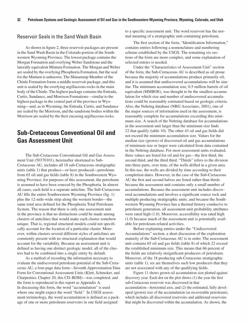
32 Petroleum Systems and Geologic Assessment of Oil and Gas in the Southwestern Wyoming Province, Wyoming, Colorado, and Utah
Reservoir Seals in the Sand Wash Basin
As shown in figure 2, three reservoir packages are present in the Sand Wash Basin in the Colorado portion of the South-western Wyoming Province. The lowest package contains the Morgan Formation and overlying Weber Sandstone and the laterally equivalent Minturn Formation. The Morgan and Weber are sealed by the overlying Phosphoria Formation, but the seal for the Minturn is unknown. The Shinarump Member of the Chinle Formation forms a middle reservoir package, and this unit is sealed by the overlying argillaceous rocks in the main body of the Chinle. The highest package contains the Entrada, Curtis, Sundance, and Morrison Formations—similar to the highest package in the central part of the province in Wyo-ming—and, as in Wyoming, the Entrada, Curtis, and Sundance are sealed by the Morrison, and the sandstone bodies within the Morrison are sealed by the their encasing argillaceous rocks.
Sub-Cretaceous Conventional Oil and Gas Assessment Unit
The Sub-Cretaceous Conventional Oil and Gas Assess-ment Unit (50370101), hereinafter shortened to Sub- Cretaceous AU, includes all 18 sub-Cretaceous stratigraphic units (table 1) that produce—or have produced—petroleum from 65 oil and gas fields (table 8) in the Southwestern Wyo-ming Province; for purposes of this assessment, the petroleum is assumed to have been sourced by the Phosphoria. In almost all cases, each field is a separate anticline. The Sub-Cretaceous AU fills the entire Southwestern Wyoming Province (fig. 1) plus the 12-mile-wide strip along the western border—the same total area defined for the Phosphoria Total Petroleum System. The reason that there is only one assessment unit in the province is that no distinctions could be made among clusters of anticlines that would make each cluster somehow unique. That is, regional structural models could not specifi-cally account for the location of a particular cluster. More-over, within clusters several different styles of anticlines are commonly present with no structural explanation that would account for the variability. Because an assessment unit is defined as having one distinct geologic model, all of the clus-ters had to be combined into a single entity by default.
As a method of recording the information necessary to evaluate the undiscovered petroleum potential of the Sub-Creta-ceous AU, a four-page data form—Seventh Approximation Data Form for Conventional Assessment Units (Klett, Schmoker, and Charpentier, Chapter 20, this CD–ROM)—was completed, and the form is reproduced in this report as Appendix A. In discussing this form, the word “accumulation” is used where one might expect the word “field.” In USGS assess-ment terminology, the word accumulation is defined as a pack-age of one or more petroleum reservoirs in one field assigned
to a specific assessment unit. The word reservoir has the nor-mal meaning of a stratigraphic unit containing petroleum.
The first section of the form, “Identification Information,” contains entries following a nomenclature and numbering scheme established by the USGS. The remaining six sec-tions of the form are more complex, and some explanation of selected entries is needed.
Under the “Characteristics of Assessment Unit” section of the form, the Sub-Cretaceous AU is described as oil prone because the majority of accumulations produce primarily oil, and it is assumed that undiscovered accumulations will be sim-ilar. The minimum accumulation size, 0.5 million barrels of oil equivalent (MMBOE), was thought to be the smallest accumu-lation for which size and number of undiscovered accumula-tions could be reasonably estimated based on geologic criteria. Also, the Nehring database (NRG Associates, 2001), one of the major sources of information used in the assessment, is reasonably complete for accumulations exceeding this mini-mum size. A search of the Nehring database for accumulations in the assessment unit larger than the minimum size finds 22 that qualify (table 10). The other 43 oil and gas fields did not exceed the minimum accumulation size. Values for the median size (grown) of discovered oil and gas accumulations of minimum size or larger were calculated from data contained in the Nehring database. For most assessment units evaluated, three values are listed for oil and for gas—the first third, the second third, and the third third. “Thirds” refers to the division into three parts, over time, of the wells drilled in a given area. In this use, the wells are divided by time according to their completion dates. However, in the case of the Sub-Cretaceous AU the first and second halves are listed rather than thirds because the assessment unit contains only a small number of accumulations. Because the assessment unit includes discov-ered accumulations and involves a significant source rock and multiple producing stratigraphic units, and because the South-western Wyoming Province has a thermal history conducive to petroleum generation, all assessment-unit probability attributes were rated high (1.0). Moreover, accessibility was rated high (1.0) because much of the assessment unit is potentially avail-able for petroleum-related activities.
Before explaining entries under the “Undiscovered Accumulations” section, a short discussion of the exploration maturity of the Sub-Cretaceous AU is in order. The assessment unit contains 65 oil and gas fields (table 8) of which 22 exceed the established minimum size. This means that 66 percent of the fields are relatively insignificant producers of petroleum. Moreover, of the 18 producing sub-Cretaceous stratigraphic units (table 1), six are themselves such low producers that they are not associated with any of the qualifying fields.
Figure 11 shows grown oil accumulation size plotted against discovery year. Each dot on the plot shows (1) the year the first sub-Cretaceous reservoir was discovered in that accumulation—horizontal axis, and (2) the estimated, fully devel-oped (grown) size of the accumulation (as recoverable petroleum), which includes all discovered reservoirs and additional reservoirs that might be discovered within the accumulation. As shown, the
33Undiscovered Oil and Gas Resources in the Phosphoria Total Petroleum System, Southwestern Wyoming Province
Table 10. Qualifying (greater than 0.5 MMBOE) oil and gas fields in the Sub-Cretaceous Conventional Assessment Unit and their producing stratigraphic units.
Figure 11. Oil accumulation size (grown) relative to discovery year; trend line is approximated (NRG Associates, 2001).
________________________________________________________ Oil fields Producing stratigraphic units________________________________________________________
Big Piney-La Barge area Nugget Bailey Dome Nugget / Tensleep Brady Nugget / Phosphoria / Weber Crooks Gap Nugget Hatfield Tensleep Iles Dome Morrison / Entrada Mahoney Dome Sundance / Tensleep Moffat Entrada / Weber Lost Soldier Morrison / Sundance / Tensleep / Madison / Flathead O’Brien Springs Nugget / Tensleep Wertz Tensleep / Darwin / Madison________________________________________________________ Gas fields Producing stratigraphic units________________________________________________________
Baxter Basin North Morrison / Nugget Butcher Knife Springs Morgan Church Buttes Morgan Ferris West Sundance Hiawatha Nugget Kinney Nugget La Barge Deep Madison Pagoda Shinarump Robin Nugget Shell Creek Nugget Table Rock area Nugget / Weber / Madison
________________________________________________________
0
1
10
100
1,000
1910 1920 1930 1940 1950 1960 1970 1980 1990 2000
ACCUMULATION-DISCOVERY YEAR
GROWNOIL-ACCUMULA
TIONSIZE
(MILLIONBARREL
SOFCRUDEOIL)
34 Petroleum Systems and Geologic Assessment of Oil and Gas in the Southwestern Wyoming Province, Wyoming, Colorado, and Utah
first oil contained in sub-Cretaceous stratigraphic units was dis-covered in 1924 and the last was discovered in 1973. As is com-monly the case, one of the first accumulations involved in the first discoveries is the largest in size or volume of petroleum. Overall, the 11 sub-Cretaceous accumulations show a decrease in size over the years, and the last discovery took place 30 years prior to the writing of this report despite continual exploration in the assessment unit. Figure 12 shows oil reservoir depth plot-ted against discovery year. In general, the trend is deeper. The first eight reservoirs discovered were at depths between about 2,000 and 4,000 ft, and the last three reservoirs discovered were at depths between about 12,000 and 14,000 ft. The conclusion is that future discoveries will most likely be as small or smaller and as deep or deeper than the historical trend.
The first nonassociated gas contained in a sub-Cretaceous stratigraphic unit was discovered in 1925, and the last was dis-covered in 1996 (fig. 13). One of the next to last accumulations discovered is the largest in size. Overall, the 11 accumulations show an increase in size over the years. Moreover, the last dis-covery took place only 7 years prior to the writing of this report. As shown in figure 14, the first four reservoirs discovered were at depths of about 4,000 ft, but the last group of reservoirs dis-covered were at depths between about 14,000 ft and 18,000 ft. Thus, if this trend continues, future discoveries of gas might be as large or larger and as deep or deeper than the historical trend.
When the initial discovery year of a petroleum-produc-ing anticline is compared with the discovery year of its first producing sub-Cretaceous accumulation, an interesting fact comes into focus. In most cases, the anticline was identified and Cretaceous or younger stratigraphic units produced, prior to the discovery of petroleum in sub-Cretaceous stratigraphic units. The elapsed time between the initial discovery of the anticline and the discovery of sub-Cretaceous petroleum ranges from 0 to 53 years, with an average elapsed time of 11 years. The average elapsed time for oil accumulations is 8 years, while the average for gas accumulations is 15 years. Thus, petroleum in sub-Cre-taceous stratigraphic units is commonly discovered by drilling deeper in anticlines currently producing petroleum.
Figure 15 shows the number of new-field wildcats plotted against their completion year. A new-field wildcat is defined as an exploratory well commonly drilled at least 2 miles from established production on a trap that has not produced oil or gas (Hyne, 1991). All totaled, 847 new-field wildcats (hereinafter shortened to wildcats) have been drilled in the Sub-Cretaceous AU. As shown in figure 15, the first well drilled to test a sub-Cre-taceous stratigraphic unit was completed in 1910. Following that, at least one well was completed for almost every year through 1938, and from 1939 through 2000, one or more wells were completed each year. Three periods of intensified exploration are apparent in the figure: 1918 through 1931 during which an aver-age of 4 wells per year were drilled (9 in 1926), 1949 through 1964 during which an average of 15 wells per year were drilled (31 in 1959), and 1968 through 1988 during which an average of 19 wells per year were drilled (32 in 1980). Since 1988, only an average of about five wildcats per year have been drilled.
Figure 16 shows the generalized locations of dry holes
that were completed in sub-Cretaceous stratigraphic units in the Southwestern Wyoming Province (IHS Energy Group, 2001). These tested locations are an indication of how active explora-tion for sub-Cretaceous accumulations has been over the years. Note that the Moxa arch, Rock Springs uplift, and Sand Wash Basin (fig. 1), and the greater Crooks Gap–Lost Soldier area (fig. 10) are clearly delineated.
Figure 17 shows the distribution of post-Eocene rocks and Quaternary sediments in the Southwestern Wyoming Province. As shown, there are areas where Laramide anticlines might be concealed below younger deposits. However, figure 18 shows the distribution of some of the commercially available two-dimensional (2-D) seismic lines in the province, and the high density of lines seems to make the discovery of a covered anticline slight. This seismic density also makes the discovery of anticlines that lack a surface expression—such as Brady—unlikely but not impossible. What is possible is the discovery of covered or subsurface anticlines using carefully designed 3-D seismic surveys, and there has been an increased use of this exploration tool in the province (table 11).
The Southwestern Wyoming Province is considered mature in regard to petroleum exploration. As shown in table 11, the days of discovering an anticline using simple field geol-ogy are most likely over. The discovery of any new anticlines will probably result from fortuitous 2-D seismic surveys or small-scale 3-D seismic surveys. Future discoveries of new sub-Cretaceous accumulations will most likely be in the deeper parts of known anticlines, and finding these will depend on the willingness of oil and gas companies to drill deeper in these structures.
Considering the declining sizes of discovered sub- Cretaceous oil accumulations over time (fig. 11), the explora-tion maturity of the Southwestern Wyoming Province (the latest sub-Cretaceous oil accumulation was discovered in 1973), and the low probability of finding covered or subsurface anticlinal structures in the Southwestern Wyoming Province, the minimum number of undiscovered oil accumulations of minimum size or larger in the Sub-Cretaceous AU was estimated to be two. The maximum estimate of eight undiscovered oil accumula-tions represents the highest number that could be justified under “best case” conditions. The median estimate was set at four. The prospects for discovering additional sub-Cretaceous gas accu-mulations seems more promising because the sizes of discovered accumulations is increasing with time (fig. 13), and the latest discovery was made in 1996. Despite this, the estimated mini-mum number of undiscovered gas accumulations in the Sub-Cre-taceous AU of minimum size or larger was set at just 5, but the maximum of 45 undiscovered gas accumulations represents an optimistic forecast for future discoveries; the estimated median was set at 17.
In regard to the sizes of undiscovered oil accumula-tions, the minimum was set equal to the minimum size of 0.5 MMBO for oil accumulations to be considered in the assessment. The maximum size of undiscovered oil fields, 90 MMBO, represents the largest size that could be justified under “best case” conditions—this is close to the size of the

35Undiscovered Oil and Gas Resources in the Phosphoria Total Petroleum System, Southwestern Wyoming Province
Figure 13. Gas accumulation size (grown) relative to discovery year; trend line is approximated (NRG Associates, 2001).
Figure 12. Oil reservoir depth relative to discovery year; trend line is approximated (NRG Associates, 2001).
0
2,000
4,000
6,000
8,000
10,000
12,000
14,000
16,000
18,000
20,0001910 1920 1930 1940 1950 1960 1970 1980 1990 2000
RESERVOIR-DISCOVERY YEAR
RES
ERVO
IRDEP
TH,O
ILACCUMULA
TIONS(FEE
T)
1
10
100
1,000
10,000
1910 1920 1930 1940 1950 1960 1970 1980 1990 2000
ACCUMULATION-DISCOVERY YEAR
GROWNGAS-ACCUMULA
TIONSIZE
(BILLIONCUBIC
FEET
OFNATU
RALGAS)
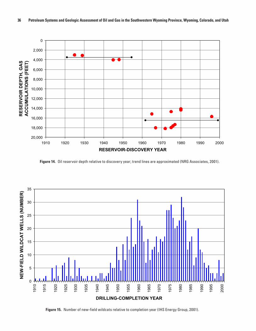
36 Petroleum Systems and Geologic Assessment of Oil and Gas in the Southwestern Wyoming Province, Wyoming, Colorado, and Utah
Figure 14. Oil reservoir depth relative to discovery year; trend lines are approximated (NRG Associates, 2001).
Figure 15. Number of new-field wildcats relative to completion year (IHS Energy Group, 2001).
0
2,000
4,000
6,000
8,000
10,000
12,000
14,000
16,000
18,000
20,0001910 1920 1930 1940 1950 1960 1970 1980 1990 2000
RESERVOIR-DISCOVERY YEAR
RES
ERVO
IRDEP
TH,G
AS
ACCUMULA
TIONS(FEE
T)
0
5
10
15
20
25
30
35
DRILLING-COMPLETION YEAR
NEW
-FIELD
WILDCATWEL
LS(NUMBER
)
1910
1915
1920
1925
1930
1935
1940
1945
1950
1955
1960
1965
1970
1975
1980
1985
1990
1995
2000

37Undiscovered Oil and Gas Resources in the Phosphoria Total Petroleum System, Southwestern Wyoming Province
Figure 16. Locations of sub-Cretaceous dry holes in Phosphoria Total Petroleum System, Southwestern Wyoming Province (IHS Energy Group, 2001).
Carbon
Grand
Garfield
Fremont
Daggett
Eagle
Jackson
Lincoln
Moffat
Natrona
Rio Blanco
Routt
Sublette
Summit
Sweetwater
Teton
Uinta
UintahDuchesne
110°111° 109° 108° 107°
40°
41°
42°
43°
UTAH
WYOMING
COLORADO
Phosphoria TotalPetroleum Systemboundary
EXPLANATION
Dry hole cellscontaining one or moredry holes that werecompleted in sub-Cretaceousstratigraphic units known toproduce petroleum(not drawn to scale)
60 Miles0 30
4 square mile)1(
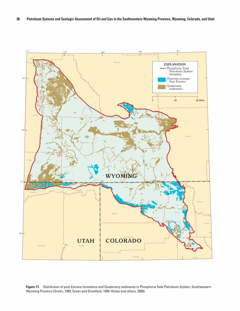
38 Petroleum Systems and Geologic Assessment of Oil and Gas in the Southwestern Wyoming Province, Wyoming, Colorado, and Utah
Figure 17. Distribution of post-Eocene formations and Quaternary sediments in Phosphoria Total Petroleum System, Southwestern Wyoming Province (Green, 1992; Green and Drovillard, 1994; Hintze and others, 2000).
Carbon
Grand
Garfield
Fremont
Daggett
Eagle
Jackson
Lincoln
Moffat
Natrona
Rio Blanco
Routt
Sublette
Summit
Sweetwater
Teton
Uinta
UintahDuchesne
110°111° 109° 108° 107°
40°
41°
42°
43°
UTAH
WYOMING
COLORADO
60 Miles0 30
Phosphoria TotalPetroleum Systemboundary
EXPLANATION
Outcrops youngerthan Eocene
Quaternarysediments
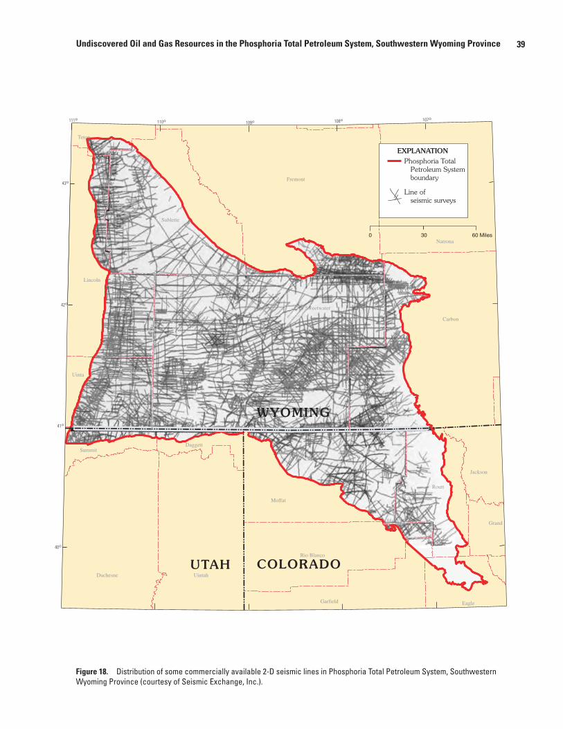
39Undiscovered Oil and Gas Resources in the Phosphoria Total Petroleum System, Southwestern Wyoming Province
Figure 18. Distribution of some commercially available 2-D seismic lines in Phosphoria Total Petroleum System, Southwestern Wyoming Province (courtesy of Seismic Exchange, Inc.).
110°111° 109° 108° 107°
40°
41°
42°
43°
UTAH
WYOMING
COLORADO
60 Miles0 30
Phosphoria TotalPetroleum Systemboundary
EXPLANATION
Line ofseismic surveys
Carbon
Grand
Garfield
Fremont
Daggett
Eagle
Jackson
Lincoln
Moffat
Natrona
Rio Blanco
Routt
Sublette
Summit
Sweetwater
Teton
Uinta
UintahDuchesne
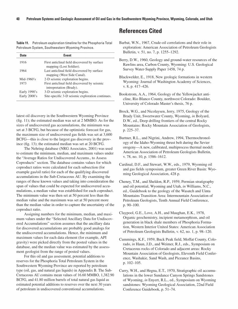
40 Petroleum Systems and Geologic Assessment of Oil and Gas in the Southwestern Wyoming Province, Wyoming, Colorado, and Utah
latest oil discovery in the Southwestern Wyoming Province (fig. 11); the estimated median was set at 2 MMBO. As for the sizes of undiscovered gas accumulations, the minimum was set at 3 BCFG, but because of the optimistic forecast for gas, the maximum size of undiscovered gas fields was set at 3,600 BCFG—this is close to the largest gas discovery in the prov-ince (fig. 13); the estimated median was set at 20 BCFG.
The Nehring database (NRG Associates, 2001) was used to estimate the minimum, median, and maximum values under the “Average Ratios for Undiscovered Accums., to Assess Coproducts” section. The database contains values for which coproduct ratios were calculated for each subsection (for example gas/oil ratio) for each of the qualifying discovered accumulations in the Sub-Cretaceous AU. By examining the ranges of these known values and taking into consideration the span of values that could be expected for undiscovered accu-mulations, a median value was established for each coproduct. The minimum value was then set at 50 percent less than the median value and the maximum was set at 50 percent more than the median value in order to capture the uncertainty of the coproduct ratio.
Assigning numbers for the minimum, median, and maxi-mum values under the “Selected Ancillary Data for Undiscov-ered Accumulations” section assumes that the ancillary data for discovered accumulations are probably good analogs for the undiscovered accumulations. Hence, the minimum and maximum values for each data element (for example, API gravity) were picked directly from the posted values in the database, and the median value was estimated by the assess-ment geologist from the range of posted values.
For this oil and gas assessment, potential additions to reserves for the Phosphoria Total Petroleum System in the Southwestern Wyoming Province are reported by petroleum type (oil, gas, and natural gas liquids) in Appendix B. The Sub-Cretaceous AU contains mean values of 16.60 MMBO, 1,382.90 BCFG, and 41.80 million barrels of total natural gas liquid as estimated potential additions to reserves over the next 30 years of petroleum in undiscovered conventional accumulations.
References Cited
Barbat, W.N., 1967, Crude-oil correlations and their role in exploration: American Association of Petroleum Geologists Bulletin, v. 51, no. 7, p. 1255–1292.
Berry, D.W., 1960, Geology and ground-water resources of the Rawlins area, Carbon County, Wyoming: U.S. Geological Survey Water-Supply Paper 1458, 74 p.
Blackwelder, E., 1918, New geologic formations in western Wyoming: Journal of Washington Academy of Sciences, v. 8, p. 417–426.
Bookstrom, A.A., 1964, Geology of the Yellowjacket anti-cline, Rio Blanco County, northwest Colorado: Boulder, University of Colorado Master’s thesis, 76 p.
Brock, W.G., and Nicolaysen, Jerry, 1975, Geology of the Brady Unit, Sweetwater County, Wyoming, in Bolyard, D.W., ed., Deep drilling frontiers of the central Rocky Mountains: Rocky Mountain Association of Geologists, p. 225–37.
Burtner, R.L., and Nigrini, Andrew, 1994, Thermochronol-ogy of the Idaho-Wyoming thrust belt during the Sevier orogeny—A new, calibrated, multiprocess thermal model: American Association of Petroleum Geologists Bulletin, v. 78, no. 10, p. 1586–1612.
Cardinal, D.F., and Stewart, W.W., eds., 1979, Wyoming oil and gas fields symposium, greater Green River Basin: Wyo-ming Geological Association, 428 p.
Cheney, T.M., and Sheldon, R.P., 1959, Permian stratigraphy and oil potential, Wyoming and Utah, in Williams, N.C., ed., Guidebook to the geology of the Wasatch and Uinta Mountains Transition Area: Intermountain Association of Petroleum Geologists, Tenth Annual Field Conference, p. 90–100.
Claypool, G.E., Love, A.H., and Maughan, E.K., 1978, Organic geochemistry, incipient metamorphism, and oil generation in black shale members of Phosphoria Forma-tion, Western Interior United States: American Association of Petroleum Geologists Bulletin, v. 62, no. 1, p. 98–120.
Cummings, K.F., 1959, Buck Peak field, Moffat County, Colo-rado, in Haun, J.D., and Weimer, R.J., eds., Symposium on Cretaceous rocks of Colorado and adjacent areas: Rocky Mountain Association of Geologists, Eleventh Field Confer-ence, Washakie, Sand Wash, and Piceance Basins, p. 102–105.
Curry, W.H., and Hegna, E.T., 1970, Stratigraphic oil accumu-lations in the lower Sundance Canyon Springs Sandstones of Wyoming, in Enyert, R.L., ed., Symposium on Wyoming sandstones: Wyoming Geological Association, 22nd Field Conference Guidebook, p. 51–74.
Table 11. Petroleum exploration timeline for the Phosphoria Total Petroleum System, Southwestern Wyoming Province.________________________________________________________ Date Event________________________________________________________
1916 First anticlinal field discovered by surface mapping (Lost Soldier). 1964 Last anticlinal field discovered by surface mapping (West Side Canal). Mid-1960’s 2-D seismic exploration begins. 1973 First anticlinal field discovered by seismic intrepretation (Brady). Early 1990’s 3-D seismic exploration begins. Early 2000’s Site-specific 3-D seismic exploration continues.________________________________________________________
41Undiscovered Oil and Gas Resources in the Phosphoria Total Petroleum System, Southwestern Wyoming Province
Dahl, Jeremy, Moldowan, J.M., and Sundararaman, Padma-nabhan, 1993, Relationship of biomarker distribution to depositional environment—Phosphoria Formation, Mon-tana, U.S.A.: Organic Geochemistry, v. 20, no. 7, p. 1001–1017.
Doelger, N.M., 1987, The stratigraphy of the Nugget Sand-stone, in Miller, W.R., ed., The Thrust Belt revisited: Wyoming Geological Association, Thirty-Eighth Field Conference, p. 163–178.
Dyer, J.R., 1954, Iles Dome, in Jensen, F.S., Sharkley, H.H., and Turner, D.S., eds., The oil and gas fields of Colorado: Rocky Mountain Association of Geologists, p. 175–177.
Edman, J.D., and Cook, Lance, 1992, Tip Top Field—U.S.A. Wyoming-Utah-Idaho Overthrust Belt, Wyoming, in Beau-mont, E.A., and Foster, N.H., compilers, Structural traps VII: American Association of Petroleum Geologists Special Publication, 27 p.
Edman, J.D., and Surdam, R.C., 1984, Diagenetic history of the Phosphoria, Tensleep, and Madison Formations, Tip Top Field, Wyoming, in McDonald, D.A., and Surdam, R.C., eds., Clastic diagenesis, Part 3, Applications of clastic dia-genesis in exploration and production: American Associa-tion of Petroleum Geologists Memoir 37, p. 317–345.
Fidlar, M.M., 1950, Baxter Basin gas fields, Sweetwater County, Wyoming, in, Harrison, J.W., ed., Southwest Wyo-ming: Wyoming Geological Association, Fifth Annual Field Conference, p. 109–110.
Fryberger, S.G. 1979, Eolian-fluviatile (continental) origin of ancient stratigraphic trap for petroleum in Weber Sandstone, Rangely oil field, Colorado: Rocky Mountain Association of Geologists, The Mountain Geologist, v. 16, no. 1, p. 1–36.
Fryberger, S.G., and Koelmel, M.H., 1986, Rangely field—Eolian system-boundary trap in the Permo-Pennsylvanian Weber Sandstone of northwest Colorado, in Stone, D.S., ed., New interpretations of northwest Colorado geology: Rocky Mountain Association of Geologists, p. 129–150.
Green, G.N., 1992, Digital geologic map of Colorado in ARC/INFO format: U.S. Geological Survey Open–File Report 92-0507.
Green, G.N., and Drovillard, P.H., 1994, Digital geologic map of Wyoming in ARC/INFO format: U.S. Geological Survey Open–File Report 94-0425.
Hansen, W.R., 1965, Geology of the Flaming Gorge area, Utah–Colorado–Wyoming: U.S. Geological Survey Profes-sional Paper 490, 196 p.
Hansen, W.R., Rowley, P.D., and Carrara, P.E., 1983, Geologic map of Dinosaur National Monument and vicinity, Utah and Colorado: U.S. Geological Survey Miscellaneous Investiga-tions Series I–1407, scale 1:50,000.
Hanson, W.E., 1959, Some chemical aspects of petroleum gen-esis, in Abelson, P.H., ed., Research in geochemistry: New York, John Wiley and Sons, p. 104–117.
Hintze, L.F., Willis, G.C., Laes, D.Y.M., Sprinkel, D.A., and Brown, K.D., 2000, Digital geologic map of Utah: Utah Geological Survey, Map 179DM.
Hoffman, M.E., and Balcells-Baldwin, R.N., 1982, Gas giant of the Wyoming thrust belt—Whitney Canyon–Carter Creek field, in Powers, R.B., ed., Geologic studies of the Cordil-leran thrust belt, volume II: Rocky Mountain Association of Geologists, p. 613–618.
Hunt, J.M., and Forsman, J.P., 1957, Relation of crude oil composition to stratigraphy in the Wind River Basin, in Bibb, T.W., Jr., ed., Southwestern Wind River Basin: Wyo-ming Geological Association Guidebook, 12th Annual Field Conference, p. 105–112.
Hyne, N.J., 1991, Dictionary of petroleum exploration, drill-ing, and production: Tulsa, Okla., PennWell Books, 625 p.
IHS Energy Group, 2001, [includes data current as of Decem-ber, 2000] PI/Dwights Plus U.S. Production and Well Data: Englewood, Colo., database available from IHS Energy Group, 15 Inverness Way East, D205, Englewood, CO 80112, U.S.A.
Johnson, E.A., 1992, Depositional history of Jurassic rocks in the area of the Powder River Basin, northeastern Wyoming and southeastern Montana: U.S. Geological Survey Bulletin 1917–J, 38 p.
Keller, E.R., and Thomaidis, N.D., 1971, Petroleum potential of southwestern Wyoming and adjacent areas, in Cram, I.H., ed., Future petroleum provinces of the United States—Their geology and potential: American Association of Petroleum Geologists, Memoir 15, p. 656–672.
Kirschbaum, M.A., and Nelson, S.N., 1988, Geologic his-tory and palynologic dating of Paleocene deposits, west-ern Rocks Springs uplift, Sweetwater County, Wyoming: Laramie, University of Wyoming, Contributions to Geology, v. 26, no. 1, p. 21–28.
Krampert, E.W., 1949, Commercial oil in Cambrian beds, Lost Soldier field, Carbon and Sweetwater Counties, Wyoming: American Association of Petroleum Geologists Bulletin, v. 33, no. 12, p. 1998–2010.
Kummel, Bernard, 1954, Triassic stratigraphy of southeastern Idaho and adjacent areas: U.S. Geological Survey Profes-sional Paper 254–H, p. 165–194.
42 Petroleum Systems and Geologic Assessment of Oil and Gas in the Southwestern Wyoming Province, Wyoming, Colorado, and Utah
Lamerson, P.R., 1982, The Fossil Basin and its relationship to the Absaroka thrust system, Wyoming and Utah, in Powers, R.B., ed., Geologic studies of the Cordilleran Thrust Belt: Rocky Mountain Association of Geologists, p. 279–340.
Lauman, G.W., 1966, Geology of Williams Fork field, Moffat County, Colorado: Rocky Mountain Association of Geolo-gists, The Mountain Geologist, v. 3, no. 3, p. 99–113.
Law, B.E., 1984, Relationships of source-rock, thermal matu-rity, and overpressuring to gas generation and occurrence in low-permeability Upper Cretaceous and lower Tertiary rocks, greater Green River Basin, Wyoming, Colorado, and Utah, in Woodward, Jane, Meissner, F.F., and Clayton, J.L., eds., Hydrocarbon source rocks of the greater Rocky Moun-tain region: Rocky Mountain Association of Geologists, p. 469–490.
Law, B.E., 1988, Geologic framework and hydrocarbon plays in the Southwestern Wyoming Basins Province: U.S. Geo-logical Survey Open–File Report 88–450–F, 29 p.
Law, B.E., 1996, Southwestern Wyoming Province (37), in Gautier, D.L., Dolton, G.L., Takahashi, K.I., and Varnes, K.L., eds., 1995 National assessment of United States oil and gas resources—Results, methodology, and supporting data: U.S. Geological Survey Digital Data Series DDS–30, release 2, one CD–ROM.
Lewan, M.D., 1985, Evaluation of petroleum generation by hydrous pyrolysis experimentation: Philosophical Transac-tions of the Royal Society of London, v. 315, p. 123–134.
Lewan, M.D., 1998, Sulphur-radical control on petroleum formation: Nature, 391, p. 164–166.
Lindquist, S.J., 1988, Practical characterization of eolian reser-voirs for development—Nugget Sandstone, Utah-Wyoming Thrust Belt: Sedimentary Geology, v. 56, p. 315–39.
Love, J.D., 1939, Geology along the southern margin of the Absaroka Range, Wyoming: Geological Society of America Special Paper 20, 123 p.
Love, J.D., 1957, Stratigraphy and correlation of Triassic rocks in Central Wyoming, in Bibb, T.W., Jr., ed., South-west Wind River Basin: Wyoming Geological Association Twelfth Annual Field Conference, p. 39–45.
Love, J.D., Johnson, C.O., Nance, H.L., Sharkey, H.H.R., Thompson, R.M., Tourtelot, H.A., and Zapp, A.D., 1945, Stratigraphic sections and thickness maps of Triassic rocks in central Wyoming: U.S. Geological Survey Preliminary Chart 17.
Maughan, E.K., 1979, Petroleum source rock evaluation of the Permian Park City Group in the northeastern Great Basin, Utah, Nevada, and Idaho, in Newman, G.W., and Goode, H.D., eds., Basin and Range symposium: Rocky Mountain Association of Geologists and Utah Geological Association, p. 523–530.
Maughan, E.K., 1984, Geological setting and some geochem-istry of petroleum source rocks in the Permian Phosphoria Formation, in Woodward, Jane, Meissner, F.F., and Clayton, J.L., eds., Hydrocarbon source rocks of the greater Rocky Mountain region: Rocky Mountain Association of Geolo-gists, p. 281–294.
McDowell, A.N., 1975, What are the problems in estimating the oil potential of a basin?: Oil and Gas Journal, v. 73, no. 23, p. 85–90.
McIver, R.D., 1962, The crude oils of Wyoming product of depositional environment and alteration, in Enyert, R.L., and Curry, W.H., III, eds., Symposium on Early Cretaceous rocks of Wyoming and adjacent areas: Wyoming Geological Association Guidebook, 17th Annual Field Conference, p. 248–251.
McKelvey, V.E., 1949, Geological studies of the Western Phosphate Field: Mining Transactions, v. 184, p. 271–279.
McKelvey, V.E., Williams, J.S., Sheldon, R.P., Cressman, E.R., Cheney, T.M., and Swanson, R.W., 1959, The Phos-phoria, Park City, and Shedhorn Formations in the western phosphate field: U.S. Geological Survey Professional Paper 313–A, 47 p.
Miller, T.S., ed., 1992, Wyoming oil and gas fields symposium greater Green River Basin and Overthrust Belt: Wyoming Geological Association, 364 p.
Momper, J.A., and Williams, J.A., 1984, Geochemical explo-ration in the Power River basin, in Demaison, G., and Mur-ris, R.J., eds., Petroleum geochemistry and basin evaluation: American Association of Petroleum Geologists Memoir 35, p. 181–191.
Mou, D.C., and Brenner, R.L., 1981, Petrology of Pennsyl-vanian Tensleep Sandstone, Lost Soldier field, Wyoming [abs]: American Association of Petroleum Geologists Bul-letin, v. 65, no. 3, p. 565.
Mou, D.C., and Brenner, R.L., 1982, Control of reservoir properties of Tensleep Sandstone by depositional and diagentic facies—Lost Soldier field, Wyoming: Journal of Sedimentary Petrology, v. 52, no. 2, p. 367–381.
Mullen, D.M., and Doelger, M.J., 1993, Ordovician Bighorn Dolomite, in Hjellming, C.A., ed., Atlas of major Rocky Mountain gas reservoirs: New Mexico Bureau of Mines and Mineral Resources, p. 82.
43Undiscovered Oil and Gas Resources in the Phosphoria Total Petroleum System, Southwestern Wyoming Province
Nelson, Erik, 1955, Iles Dome, in Ritzma, H.R., ed., Geol-ogy of northwest Colorado: Rocky Mountain Association of Geologists and Intermountain Association of Petroleum Geologists, p. 90–91.
NRG Associates, 2001, [includes data current as of December 1999] The significant oil and gas fields of the United States: NRG Associates, Inc., P.O. Box 1655, Colorado Springs, CO 80901, U.S.A.
Nuss, N.W., Fox, J.E., Lambert, P.W., Mast, R.F., and Rein, R.D., 1975, Study of reservoir quality in Tensleep Sand-stone, western Wyoming [abs]: American Association of Petroleum Geologists Bulletin, v. 59, no. 5, p. 918–919.
Oborne, H.W., 1961, Iles Dome field, in Parker, J.M., ed., Oil and gas fields volume, Colorado-Nebraska: Rocky Moun-tain Association of Geologists, p. 158–159.
Pacht, J.A., 1977, Diagenesis of the Nugget Sandstone—West-ern Wyoming and north-central Utah, in Heisey, E.L., Lawson, D.E., Norwood, E.R., Wach, P.H., and Hale, L.A., eds., Rocky Mountain Thrust Belt geology and resources: Wyoming Geological Association, 29th Annual Field Con-ference, p. 207–219.
Pawlewicz, M.J., and Finn, T.M., 2002, Vitrinite reflectance data of the Greater Green River Basin, southwestern Wyo-ming, northwestern Colorado, and northeastern Utah: U.S. Geological Survey Open-File Report 02–339, 2 p.
Peterson, J.A., 1984, Permian stratigraphy, sedimentary facies, and petroleum geology, Wyoming and adjacent areas, in Goolsby, Jim, and Morton, Doug, eds., The Permian and Pennsylvanian geology of Wyoming: Wyoming Geological Association, 35th Annual Field Conference, p. 25–64.
Peterson, F., 1994, Sand dunes, sabkhas, streams, and shallow seas—Jurassic paleogeography in the southern part of the Western Interior Basin, in Caputo, M.V., Peterson, J.A., and Franczyk, K.J., eds., Mesozoic systems of the Rocky Moun-tain Region, U.S.A.: Rocky Mountain Section, Society of Economic Mineralogists and Paleontologists, p. 233–272.
Picard, M.D., 1977, Petrology of the Jurassic Nugget Sand-stone, northwest Utah and southwest Wyoming, in Heisey, E.L., Lawson, D.E., Norwood, E.R., Wach, P.H., and Hale, L.A., eds., Rocky Mountain Thrust Belt geology and resources: Wyoming Geological Association, 29th Annual Field Conference, p. 239–258.
Picard, M.D., 1978, Stratigraphy of Triassic rocks in west- central Wyoming, in Boyd, R.G., ed., Resources of the Wind River Basin: Wyoming Geological Association 30th Annual Field Conference, p. 101–130.
Pipiringos, G.N., and O’Sullivan, R.B., 1978, Principal uncon-formities in Triassic and Jurassic rocks—Western Interior United States—A preliminary survey: U.S. Geological Survey Professional Paper 1035–A, 29 p.
Pott, R.L., and DeVore, S.F., 1951, The Lost Soldier field, Sweetwater County, Wyoming, in Brinker, W.F., ed., South-central Wyoming: Wyoming Geological Association, Sixth Annual Field Conference, p. 103–107.
Powell, T.G., Cook, P.J., and McKirdy, D.M., 1975, Organic geochemistry of phosphorites—Relevance to petroleum genesis: American Association of Petroleum Geologists Bulletin, v. 59, no. 4, p. 618–632.
Reynolds, M.W., 1976, Influence of recurrent Laramide struc-tural growth on sedimentation and petroleum accumulation, Lost Soldier area, Wyoming: American Association of Petroleum Geologists Bulletin, v. 60, no. 1, p. 12–32.
Reynolds, M.W., Ahlbrandt, T.S., Fox, J.E., and Lambert, P.W., 1976, Coastal sedimentation model, Tensleep Sand-stone (Pennsylvanian), central Wyoming [abs]: American Association of Petroleum Geologists Bulletin, v. 60, no. 8, p. 1407–1408.
Ryder, R.T., 1988, Greater Green River Basin, in Sloss, L.L., ed., Sedimentary cover—North American craton, U.S.: Geological Society of America, The geology of North America, volume D–2, p. 154–165.
Shaw, A.B., and Deland, C.R., 1955, Cambrian of southwest-ern Wyoming, in Camp, R.J., chairman, Green River Basin: Wyoming Geological Association Field Conference Guide-book, no. 10, p. 38–42.
Sheldon, R.P., 1963, Physical stratigraphy and mineral resources of Permian rocks in western Wyoming: U.S. Geo-logical Survey Professional Paper 313–B, 273 p.
Sheldon, R.P., 1967, Long-distance migration of oil in Wyo-ming: The Mountain Geologist, v. 4, no. 2, p. 53–65.
Silliman, J.E., Li, Maowen, Yao, Huangxin, and Hwang, Rong, 2002, Molecular distribution and geochemical implications of pyrrolic nitrogen compounds in the Permian Phosphoria Formation derived oils of Wyoming: Organic Geochemistry, v. 33, p. 527–544.
Stone, D.S., 1967, Theory of Paleozoic oil and gas accumula-tion in Big Horn Basin, Wyoming: American Association of Petroleum Geologists Bulletin, v. 51, no. 10, p. 2056–2114.
Swanson, R.W., McKelvey, V.E., and Sheldon, R.P., 1953, Progress report on investigations of western phosphate deposits: U.S. Geological Survey Circular 297, 16 p.
Teflian, S., 1954, Moffat, in Jensen, F.S., Sharkley, H.H., and Turner, D.S., eds., The oil and gas fields of Colorado: Rocky Mountain Association of Geologists, p. 229–230.
44 Petroleum Systems and Geologic Assessment of Oil and Gas in the Southwestern Wyoming Province, Wyoming, Colorado, and Utah
Thomaidis, N.D., 1973, Church Buttes arch, Wyoming and Utah, in Scheel, E.M., ed., Symposium and core seminar on the geology and mineral resources of the greater Green River Basin: Wyoming Geological Association, 25th Field Conference Guidebook, p. 35–39.
Tweto, Ogden, 1981, Geologic map of the Craig 1o X 2o quadrangle, northwestern Colorado: U.S. Geological Survey Miscellaneous Investigations Series I–972, scale 1:500,000.
Vieaux, Don, and Haymaker, E.R., 1955, Moffat Dome, Moffat County, Colorado, in Ritzma, H.R., ed., Geology of northwest Colorado: Rocky Mountain Association of Geologists and Intermountain Association of Petroleum Geologists, p. 92–94.
Wach, P.H., 1977, The Moxa Arch, an overthrust model, in Heisey, E.L., Norwood, E.R., Wach, P.H., and Hale, L.A., eds., Rocky Mountain Thrust Belt geology and resources: Wyoming Geological Association, 29th Annual Field Con-ference, p. 651–664.
Wardlaw, B.R., 1995, Permian conodonts, in Scholle, P.A., Peryt, T.M., and Ulmer-Scholle, D.S., eds., The Permian of northern Pangea, volume 1, Paleogeography, paleoclimates, stratigraphy: Berlin, Springer-Verlag, p. 186–195.
Wardlaw, B.R., and Collinson, J.W., 1986, Paleontology and deposition of the Phosphoria Formation: Laramie, Univer-sity of Wyoming, Contributions to Geology, v. 24, p. 107–142.
West, Jim, 1975, Champlin gearing up to produce Brady Deep Unit’s Weber reservoir: Oil and Gas Journal, June 23, 1975, p. 87–93.
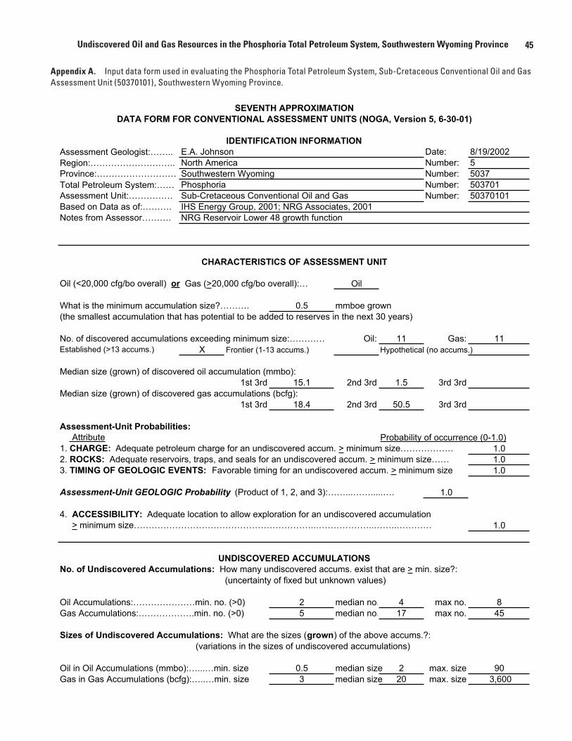
45Undiscovered Oil and Gas Resources in the Phosphoria Total Petroleum System, Southwestern Wyoming Province
Appendix A. Input data form used in evaluating the Phosphoria Total Petroleum System, Sub-Cretaceous Conventional Oil and Gas Assessment Unit (50370101), Southwestern Wyoming Province.
SEVENTH APPROXIMATIONDATA FORM FOR CONVENTIONAL ASSESSMENT UNITS (NOGA, Version 5, 6-30-01)
Assessment Geologist:…….. E.A. Johnson Date: 8/19/2002Region:……………………….. North America Number: 5Province:……………………… Southwestern Wyoming Number: 5037Total Petroleum System:…… Phosphoria Number: 503701Assessment Unit:…………… Sub-Cretaceous Conventional Oil and Gas Number: 50370101Based on Data as of:………. IHS Energy Group, 2001; NRG Associates, 2001Notes from Assessor………. NRG Reservoir Lower 48 growth function
CHARACTERISTICS OF ASSESSMENT UNIT
Oil (<20,000 cfg/bo overall) or Gas (>20,000 cfg/bo overall):… Oil
What is the minimum accumulation size?………. 0.5 mmboe grown(the smallest accumulation that has potential to be added to reserves in the next 30 years)
No. of discovered accumulations exceeding minimum size:………… Oil: 11 Gas: 11Established (>13 accums.) X Frontier (1-13 accums.) Hypothetical (no accums.)
Median size (grown) of discovered oil accumulation (mmbo):1st 3rd 15.1 2nd 3rd 1.5 3rd 3rd
Median size (grown) of discovered gas accumulations (bcfg):1st 3rd 18.4 2nd 3rd 50.5 3rd 3rd
Assessment-Unit Probabilities: Attribute Probability of occurrence (0-1.0)1. CHARGE: Adequate petroleum charge for an undiscovered accum. > minimum size……………… 1.02. ROCKS: Adequate reservoirs, traps, and seals for an undiscovered accum. > minimum size…… 1.03. TIMING OF GEOLOGIC EVENTS: Favorable timing for an undiscovered accum. > minimum size 1.0
Assessment-Unit GEOLOGIC Probability (Product of 1, 2, and 3):……...…….....…. 1.0
4. ACCESSIBILITY: Adequate location to allow exploration for an undiscovered accumulation > minimum size……………………………………………………..………………..……..………… 1.0
UNDISCOVERED ACCUMULATIONSNo. of Undiscovered Accumulations: How many undiscovered accums. exist that are > min. size?:
(uncertainty of fixed but unknown values)
Oil Accumulations:…………………min. no. (>0) 2 median no. 4 max no. 8Gas Accumulations:……………….min. no. (>0) 5 median no. 17 max no. 45
Sizes of Undiscovered Accumulations: What are the sizes (grown) of the above accums.?: (variations in the sizes of undiscovered accumulations)
Oil in Oil Accumulations (mmbo):…...…min. size 0.5 median size 2 max. size 90Gas in Gas Accumulations (bcfg):…..…min. size 3 median size 20 max. size 3,600
IDENTIFICATION INFORMATION
46 Petroleum Systems and Geologic Assessment of Oil and Gas in the Southwestern Wyoming Province, Wyoming, Colorado, and Utah
[MMBO, million barrels of oil. BCFG, billion cubic feet of gas. MMBNGL, million barrels of natural gas liquids. Results shown are fully risked estimates. For gas fields, all liquids are included under the NGL (natural gas liquids) category. F95 denotes a 95-percent chance of at least the amount tabulated. Other fractiles are defined similarly. Fractiles are additive under the assumption of perfect positive correlation. TPS is Total Petroleum System. AU is Assessment Unit. CBG denotes coalbed gas. Shading indicates not applicable]
Appendix B. Summary of assessment results for the Phosphoria Total Petroleum System, Sub-Cretaceous Conventional Oil and Gas Assessment Unit (50370101), Southwestern Wyoming Province.
Appendix A. Input data form used in evaluating the Phosphoria Total Petroleum System, Sub-Cretaceous Conventional Oil and Gas Assessment Unit (50370101), Southwestern Wyoming Province.—Continued
Assessment Unit (name, no.)Sub-Cretaceous Conventional Oil and Gas, Assessment Unit 50370101
AVERAGE RATIOS FOR UNDISCOVERED ACCUMS., TO ASSESS COPRODUCTS(uncertainty of fixed but unknown values)
Oil Accumulations: minimum median maximumGas/oil ratio (cfg/bo)………………………...……… 969 1,938 2,907NGL/gas ratio (bngl/mmcfg)…………………....…. 18 36 54
Gas Accumulations: minimum median maximumLiquids/gas ratio (bliq/mmcfg)….…………..…….. 15 30 45Oil/gas ratio (bo/mmcfg)………………………….…
SELECTED ANCILLARY DATA FOR UNDISCOVERED ACCUMULATIONS(variations in the properties of undiscovered accumulations)
Oil Accumulations: minimum median maximumAPI gravity (degrees)…………………….…………. 31 36 55Sulfur content of oil (%)………………………...….. 0.1 0.45 1.4Drilling Depth (m) ……………...…………….…….. 539 1,719 4,195Depth (m) of water (if applicable)……………...…..
Gas Accumulations: minimum median maximumInert gas content (%)……………………….....…… 0.7 1.5 10CO2 content (%)……………………………….....… 0.1 5.2 70Hydrogen-sulfide content (%)………………...……. 0 0 10Drilling Depth (m)…………………………………… 921 4,562 6,100Depth (m) of water (if applicable)………………….
Volume Title Page
F95 F50 F5 Mean F95 F50 F5 Mean F95 F50 F5 Mean
Oil 3.80 12.70 43.60 16.60 6.70 24.00 85.90 32.20 0.20 0.80 3.20 1.20Gas 206.20 1,069.00 3,480.00 1,350.70 5.90 31.20 107.20 40.60
3.80 12.70 43.60 16.60 212.90 1,093.00 3,565.90 1,382.90 6.10 32.00 110.40 41.80
Fieldtype
Phosphoria TPS
Sub-Cretaceous Conventional Oiland Gas AU
Gas (BCFG)
Total undiscovered resources
NGL (MMBNGL)Oil (MMBO)Total Petroleum Systems(TPS)and Assessment Units (AU)
Total conventionalresources