Embed Size (px)
Citation preview

South Downs Local Plan: Preferred Options
Assessment of Site Allocations against Major
Development Considerations
Technical Report
October 2015

2
Contents
Chapter 1: Introduction
Chapter 2: Methodology
Chapter 3: Identification of Major Sites
Chapter 4: Assessment of Major Sites
Chapter 5: Conclusions
Appendices
Appendix A: Allocation Sites: Assessment Table
Appendix B: Major Site Assessments
Appendix C: Sustainability Appraisal Findings for the Major Sites

3
Chapter 1: Introduction
Background
1.1 Paragraph 116 of the National Planning Policy Framework (NPPF) states that:
“116. Planning permission should be refused for major developments in these designated
areas [National Parks, the Broads, and AONBs] except in exceptional circumstances and
where it can be demonstrated they are in the public interest. Consideration of such
applications should include an assessment of:
The need for the development, including in terms of any national considerations, and
the impact of permitting it, or refusing it, upon the local economy;
The cost of, and scope for, developing elsewhere outside the designated area, or
meeting the need for it in some other way; and
Any detrimental effect on the environment, the landscape and recreational
opportunities, and the extent to which that could be moderated”
1.2 Legal opinion has been obtained on the definition of ‘major development’ in this context (see below) and on whether allocation of a major site in a Local Plan can only be made if the requirements of para. 116 are met. The conclusion of James Maurici QC on the latter point is ‘that the matters in the bullet points in para. 116 would have to be addressed in the plan-making process.’
1.3 The South Downs Local Plan: Preferred Options proposes to allocate 17 sites for residential development, together with a further three strategic sites for mixed use development, two of which include housing. In addition sites will be allocated in Neighbourhood Development Plans, which must be in general conformity with the strategic polices of the Local Plan.
1.4 This report addresses the 17 sites allocated in the South Downs Local Plan: Preferred Options document (but not the strategic sites) in order to consider:
a. Which allocations are considered to be major development; and b. Whether the development proposed on these sites would constitute exceptional
circumstances in the public interest taking account of the assessments required by paragraph 116.
1.5 The strategic sites allocated in the Local Plan are clearly major development and subject to paragraph 116. They were not considered as part of this process, having already been considered in Chapter 8 of the Local Plan: Preferred Options document (paragraphs 8.8 to 8.25), the Lewes Joint Core Strategy and Fernhurst Neighbourhood Development Plan process
1.6 In regard to North Street Quarter and adjoining land in Lewes, the decision to allocate the site, including its consideration by the Inspector at the Examination in Public, has already involved an assessment of the need for it, of potential sites elsewhere and of its environmental effects. The Syngenta site at Fernhurst was also assessed against major development considerations as part of the neighborhood plan preparation. It was not therefore considered necessary to repeat these processes, although a further assessment may be required when further information is available about the nature and quantity of development proposed at Syngenta.

4
1.7 With respect to the proposed development at Shoreham Cement Works, the consideration in paragraphs 8.8 to 8.25 covers many of the considerations in general terms, while the discussion of constraints, opportunities and development and the criteria in Policy SD32 address environmental impacts. However, the nature and quantity of the proposed development is insufficiently defined to enable a more detailed assessment of exceptional circumstances to be made at this stage. Further work may be undertaken if and when more specific proposals are developed.
The Definition of Major Development
1.8 The NPFF does not define major development. The SDNPA sought a legal opinion on this matter, initially in 2011 in relation to paragraph 22 of PPS7 which preceded the NPPF. This opinion, from James Maurici QC, was reviewed and updated in 2013 to take account of the NPPF and the Planning Practice Guidance (PPG), as well as relevant case law which had emerged in the meantime.
1.9 The case law and PPG confirm that whether a proposed development should be treated as a major development will be a matter for the relevant decision taker, taking into account the proposal in question and the local context.
1.10 In relation to a case in the SDNP in which the Inspector found a proposal for 30 dwellings not to be major development because the impact would be confined to the local area, Maurici considered that this cannot possibly be a test of general application. He found that:
‘The Inspector in the Burlands Field decision appears to have reached his
conclusions on whether the development was “major development” only after a
careful assessment of impacts. In my opinion, that is to put the cart before the horse.
While it may well be appropriate, as part of the determination of whether a proposal
is “major development”, to consider whether, by reason of its scale, character or
nature, it has the potential to have a serious adverse impact on a National Park or
AONB, “major developments” are not defined in paragraph 116 of the NPPF by their
actual, assessed impacts but by the nature of the development.’
1.11 Maurici sets out principles – derived from the caselaw, guidance and appeal decisions - to be applied by decision makers when determining whether a proposal is for major development. These are summarised as follows:
1. The determination is a matter of planning judgment to be decided by the decision
maker in light of all the circumstances and the context of the site.
2. The phrase “major development” is to be given its ordinary meaning.
Accordingly, it would be wrong in law to:
a. Apply the definition of major development contained in the Town and Country
Planning (Development Management Procedure) (England) Order 2010.
b. Apply any set or rigid criteria.
c. Restrict the definition to proposals that raise issues of national significance.
1.12 The decision maker may consider whether the development has the potential to have a serious adverse impact on the natural beauty and recreational opportunities provided by a National Park or AONB by reason of its scale, character or nature. However, that does not require (and ought not to include) an in-depth consideration of whether the development will in fact have such an impact. Instead, a prima facie assessment of the potential for such impact, in light of the scale, character or nature of the proposed development is sufficient.
5
1.13 As a matter of planning judgement, the decision maker must consider the application
in its local context. The same development may amount to “major development” in one National Park, but not in another; or in one part of a National Park, but not in another part of the same National Park.
1.14 The application of criteria such as whether the development is EIA development, whether it meets the 2010 Order definition, or whether it requires an appraisal of the likely traffic, health, or retail implications of the proposal will all be relevant considerations, but will not determine the matter and may not even raise a presumption either way.
1.15 Having considered all the circumstances, including the local context, the decision maker must take a common sense view on whether the proposed development can appropriately be described – in ordinary language - as “major development”. This will normally be much larger than 6 housing units.
1.16 These principles confirm the conclusions reached by Maurici in his earlier 2011 opinion. The only difference is that the 2011 opinion stated that criteria may be used to raise a presumption that a development is ‘major development’. Such criteria might include that the development is EIA development, that it is within Schedule 2 of EIA Regulations 1999, that it is within the 2010 Order definition (referred to as a ‘useful starting point’), and that it requires an appraisal/ assessment of traffic, health, and retail implications. As set out above, Maurici no longer considers these to be determining factors, and they may not even raise a presumption either way.
1.17 In a further opinion dated October 2011, Maurici clarifies that any consideration of what is ‘major development’ should encompass wildlife and cultural heritage as a limb of the statutory purposes of a National Park. He also considered that “scenic beauty” (as used by the NPPF and PPG) is concerned with what can be seen, and “natural beauty” as now defined by statute is clearly wider, encompassing wildlife and cultural heritage. In relation to principle 3 above, therefore, potential impacts on ecology, geodiversity, archaeology and cultural heritage should be taken into account in addition to ‘scenic beauty and landscape’.
1.18 This report applies all the above principles to the 17 site allocations, but in particular considers the potential for serious adverse impact as described in principle 3, taking account of the local context as set out in principle 4.

6
Chapter 2: Methodology
Stage 1: Identification of Major Sites
2.1 For each of the sites proposed for allocation, a desk top assessment was made based on the information provided in the Local Plan: Preferred Options document, in the Strategic Housing Land Availability Assessment (SHLAAA), and in the Sustainability Appraisal of the Local Plan: Preferred Options document. Reference was also made to the satellite and street views on Google Maps. The following information was set out in tabular form:
Site size in hectares
Capacity in terms of numbers of dwellings
Site description
Landscape assessment
Constraints in as far as they are relevant to environmental or recreational impacts, including nature conservation and cultural heritage designations; and requirements for ecological, archaeological, heritage, landscape and visual impact, or transport assessments.
Summary of Habitat Regulations Assessment (where relevant)
Summary of the Sustainability Appraisal 2.2 Based on this information, a conclusion was reached as to whether or not the
development proposed for the site has the potential to have a serious adverse impact on the natural beauty and recreational opportunities provided by the National Park. The reasons for this conclusion were set out.
Stage 2: Assessment of Major Sites
2.3 Each site that is considered to be major development at Stage 1 was then assessed against the following considerations derived from paragraph 116 of the NPPF:
The need for development in the location proposed, taking account of any local need identified by the relevant housing authority and bearing in mind that housing in the National Park should focus on the needs of its local communities;
The possible impact on the local economy, in particular any that which is specific to the site or location (as opposed to general benefits such as on the construction industry);
The scope for meeting the need in some other way, on the assumption that it is a local need which should ideally not be met outside the designated area;
Detrimental effects on the environment (including wildlife and cultural heritage) and the extent to which the effects can be moderated;
Detrimental effects on the landscape and the extent to which the effects can be moderated;
Detrimental effects on recreational opportunities and the extent to which the effects can be moderated.
2.4 A conclusion was then drawn as to whether, at this stage, there is a reasonable expectation that the exceptional circumstances exist and that it could be demonstrated that development would be in the public interest.

7
Chapter 3: Identification of Major Sites
3.1 The results of the Stage 1 assessment are set out in the table in Appendix A. Of the 17 sites the following are considered definitely not major development as a result of their modest size/ capacity and (in the case of the sites at Clements Close, Binsted, Itchen Abbas House, and Long Priors, West Meon) their Low/ Medium Landscape Sensitivity:
Land at New Road, Midhurst – 8 dwellings, 0.1 has.
Land at Clements Close, Binsted -12 dwellings, 0.5 has.
Land at Kiln Lane, Buriton – 7 dwellings, 0.2 has.
Land at Itchen Abbas House – 8 dwellings, 0.7 has.
Land south of Loppers Ash, South Harting - 8 dwellings, 0.4 has.
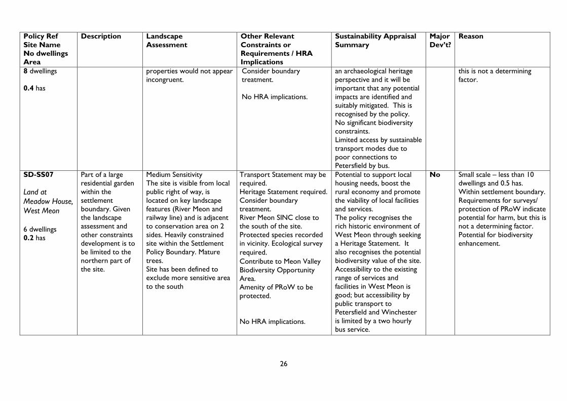
Land at Meadow House, West Meon – 6 dwellings, 0.2 has.
Land at Long Priors, West Meon – 10 dwellings, 0.3 has.
3.2 On the other hand, the land at Old Malling Farm, Lewes (proposed for 200 dwellings on a net area of 6.6 has.) is clearly major development by virtue of its scale, its landscape impact, its character as a green finger, its proximity to a Conservation Area and Listed buildings, its archaeological potential, its proximity to ecological designations, and its impact on views from the Ouse Valley Way. As a result it clearly has potential for serious adverse impact on natural beauty and recreational opportunities.
3.3 The following remaining sites are more marginal:
Land at Petersfield Road, Midhurst – 40 dwellings, 2.4 has.
Land at Lamberts Lane, Midhurst – 15 dwellings, 0.4 has.
Land at Brookland Way, Coldwaltham – 20 dwellings, 1.0 has.
Land east of Cowdray Road, Easebourne –14 dwellings, 0.7 has.
Land at Petersfield Road, Greatham –30 dwellings, 2.4 has.
Land between Church Lane and the A273, Pyecombe – 8 dwellings, 1 ha.
Land at Farnham Road, Sheet – 15 dwellings, 0.9 has.
Land at Hoe Court, Lancing- 15 dwellings, 1 ha.
Land at Normansal Park Avenue, Seaford – 20 dwellings, 1 ha.
3.4 The table at Appendix A gives relevant information on a site by site basis. The following paragraphs compare the sites from the point of view of key characteristics which will influence whether or not they should be considered major development.
Scale
3.5 In relation to the ‘starting point’ of the 2010 Order referred to in the 2011 Maurici opinion, all but the Pyecombe site are proposed for 10 or more dwellings and all apart from Lamberts Lane are at least 0.5 hectares. However, the 2013 opinion downplays the significance of this to a ‘relevant consideration’ that will not determine the matter and may not even raise a presumption either way.

8
3.6 The two largest sites, at Petersfield Road, Midhurst and in Greatham, are the same
size (2.4 has) with capacities of 40 and 30 dwellings respectively. The size of the Greatham site is however more important in the context of Greatham village which only has about 400 dwellings and 800 population, while the net area of the Midhurst site may be lower once the retention and protection of existing trees is taken into account. The Pyecombe site is also large in area (1 hectare) compared to the size of the village (about 200 population), but is only proposed for 8 dwellings.
3.7 In relation to the size of the village (850 population in the parish which also includes Watersfield), the 1 hectare, 20 dwelling site at Coldwaltham is large, whereas the similar sized sites at Lancing and Seaford are less significant because they relate to much larger urban areas outside the National Park. Moreover the site at Seaford is likely to be smaller than one hectare once the retention of the existing wooded area is taken into account.
3.8 The sites at Easebourne and Sheet are similar in size, both being smaller than the other marginal sites (apart from Lamberts Lane), but above the 2010 Order threshold. They should, however, be considered within the context of the relatively large settlements of Midhurst and Petersfield, since Easebourne and Sheet, while administratively separate parishes, are physically and functionally linked to their neighbouring towns.
3.9 In terms of scale, therefore, taking account both proposed capacity and the local context of the settlements to which they relate, only the Coldwaltham and Greatham sites are clearly major.
Local Context / Enclosure
3.10 Both the sites in Midhurst and those in Easebourne and Sheet are enclosed within built development, albeit that one side of the Sheet site is formed by the railway line. The site at Pyecombe is also contained within urban development, with main roads and a petrol station forming two of its boundaries and housing on the other sides.
3.11 When seen in the context of recent development to the east and slightly older development to the south, together with the strong tree belt to the west, beyond which is further built development, the Seaford site is semi-enclosed.
3.12 The site at Greatham, although not strictly speaking previously developed land (apart from the bungalow), is on the site of a former nursery and is surrounded on three sides by development, including community facilities, but the Local Plan: Preferred Options proposes to omit the existing development to the west and south-west from the Settlement Boundary. If this proposal remains in the next stages of plan preparation, development of the nursery site could appear anomalous in the context of Greatham, representing a significant extension into the open countryside as defined by the Local Plan.
3.13 The sites at Lancing and Coldwaltham are seen as incursions into the open countryside.
3.14 If considered on the sole basis of the location of the sites in relation to nearby development, and the extent to which they extend into the open countryside, either existing or (in the case of Greatham) proposed, then the allocations at Lancing, Coldwaltham and Greatham are major development.

9
Landscape Sensitivity
3.15 Most of the marginal sites have Medium Landscape Sensitivity, with one (Petersfield Road, Midhurst) only having Low/ Medium Landscape Sensitivity, despite its size, the number of mature trees which might be affected by development, and the requirement for a further Landscape Appraisal (LA)1. Of the five sites with Medium Landscape Sensitivity, those at Greatham, Easebourne, Pyecombe and Lamberts Lane, Midhurst, nevertheless require an LA; but that at Sheet does not.
3.16 Three sites have Medium/ High Landscape Sensitivity and require an LA. These are the site at Coldwaltham and the sites on the edge of the urban areas to the south of the National Park, at Lancing and Seaford. The Lancing and Seaford sites have been reduced in area so that the more open parts of the sites are no longer included, but this has not yet been reflected in the landscape assessment. In the case of the Lancing site, most of the factors which led to its higher sensitivity no longer apply to the reduced site.
3.17 The Seaford site, however, is still sensitive due to the loss of local open space (including recently constructed play equipment within a wooded area and a multi-use games area (MUGA)), the views out of the site to the sea, woodland and the downs, and the links to nearby public rights of way. Some of these issues may be more to do with recreational potential than landscape per se but are nevertheless important. It may be possible to mitigate these impacts by retention of some open space as part of a planning brief for the site and by the re-provision of open space within the area to the north that was excluded from the original site.
3.18 The Coldwaltham site was originally High Sensitivity but was significantly reduced in area by excluding a large extension of the village to the south-west, thus reducing its sensitivity to Medium / High. This reflects the proximity to an SSSI/ SPA/ Ramsar site and to Open Access Land.
3.19 Looking just at the factors of Landscape Sensitivity and requirements for an LA, the two proposed allocations with a case for being considered major development are those at Seaford and Coldwaltham.
Need for Further Assessments
3.20 Landscape assessment of most sites would be required as part of any application process and in some cases this may be a Landscape and Visual Impact Assessment as part of an EIA following the screening of proposals.
3.21 In addition, both marginal sites in Midhurst, the site at Coldwaltham, the site at Easebourne, and the site at Lancing require ecological surveys. The Greatham and
1 The Local Plan: Preferred Options actually refers to Landscape and Visual Impact Assessments
(LVIAs). The Guidelines for Landscape and Visual Impact Assessment (3rd Ed) describes two types
of landscape assessment - the LVIA as part of Environmental Impact Assessment (EIA) and the less
formal Landscape Appraisal for projects which fall below the EIA threshold. The latter more flexible
type of assessment will usually be more appropriate for the allocation sites (apart from Old Malling
Farm).

10
Coldwaltham sites will require an assessment of their impact on the nearby SPAs/ SACs and this may be a formal Habitat Regulations Assessment.
3.22 All marginal sites apart from those at Pyecombe, Sheet, and Seaford do or may require transport statements. The sites at Lamberts Lane, Midhurst, Easebourne, and Greatham require heritage statements and the Greatham site also requires an archaeological assessment. The requirements for further assessments can be an indication of the potential for serious harm and therefore of a major site.
3.23 Subject to the retention of protected/ existing mature trees and hedgerows, the site at Farnham Road, Sheet does not require further surveys or assessments, implying that there is no potential for serious harm. The sites at Pyecombe and Seaford also do not require further assessments other than the LVIAs (and subject to retention of protected /existing mature trees and hedgerows).
3.24 Such requirements are downplayed in the 2013 opinion as only ‘relevant considerations’, so the absence of such requirements cannot determine the matter of whether or not these sites are major. However, on the basis of the greatest need for further assessments, those most likely to be major sites are at Easebourne, Greatham, and Lamberts Lane, Midhurst.
Recreational Opportunities
3.25 The identification of major sites must also consider the potential for serious harm to recreational opportunities in the National Park (pursuant to the second national park purpose). Such issues are raised in relation to most of the sites, usually as a result of impact on views from public rights of way and in one case from Open Access Land. The exceptions are the two sites in Midhurst and the site at Easebourne.
3.26 The Lamberts Lane, Midhurst site does raise the issue of loss of community facilities but this is not considered to be an issue in relation to purpose two recreational opportunities (and in any case many facilities have been replaced in the new school). Similarly the issue of loss of open space, including the play area and MUGA referred to above, is important for the community in Seaford outside the National Park but is not strictly related to the recreational opportunities at which the second national park purpose is aimed.
Conclusion
3.27 Seven of the allocations are clearly not major development and development of the site at Old Malling Farm undoubtedly would be major development.
3.28 On balance, given that the Maurici opinion advises that the key consideration is whether the development has the potential to have a serious adverse impact on the natural beauty and recreational opportunities (my emphasis), I have come to the following conclusions about the remaining nine ‘marginal sites’.
3.29 The two sites in Midhurst and the site in Easebourne do not constitute major development proposals as a result of their scale in the local context of a market town, their Medium or Medium/ Low landscape Sensitivity, their relative enclosure within existing development and (in relation to the Petersfield Road site) the lack of environmental constraints. The allocation in Sheet is also not major development for similar reasons. The site at Pyecombe is not major, despite its relatively large area in

11
relation to the village, because of its low proposed capacity, its Medium Landscape Sensitivity, its containment by urban uses and its limited requirement for further assessments.
3.30 The marginal site at Lancing is not major development, having been reduced in size to exclude the more open and sensitive areas, including the area crossed by and near to the public rights of way and adjoining the Local Nature Reserve. The site in Seaford is, on balance, considered not to be major development given its scale in relation to the town of Seaford, its semi-enclosed nature, and the requirement to either retain and /or relocate public open space and play/ games areas.
3.31 The allocations at Brookland Way, Coldwaltham and Petersfield Road, Greatham are considered to be major development because of their scale in relation to the size of the villages, Medium / High Landscape Sensitivity (Coldwaltham only), their unenclosed nature (in the case of Greatham in relation to proposed changes to the settlement boundary), need for further assessments (Greatham), and their proximity to Special Protection areas (SPAs), Special Areas of Conservation (SACs), Sites of Special Scientific Interest (SSSIs), and (in the case of Coldwaltham) a Ramsar site.
3.32 As a result only the following marginal sites qualify as major sites for the purposes of paragraph 116 of the NPPF and are taken forward for Stage 2 assessment:
Land at Old Malling Farm, Lewes
Land at Brookland Way, Coldwaltham.
Land at Petersfield Road, Greatham
12
Chapter 4: Assessment of Major Sites
4.1 This chapter sets out the conclusions reached with regard to whether development
proposed for the three major sites is likely to be justified as exceptional circumstances
in the public interest. Before doing so, it considers what might be considered to be an
exceptional need in the context of the South Downs National Park.
Definition of Need
4.2 The first consideration required by paragraph 116 is that of need for the development.
It should be borne in mind that national park authorities are not obliged to meet
objectively assessed needs in full where to do so would give rise to conflict with
national planning policies and with their statutory purposes. The 2010 DEFRA Circular
(‘English National Parks and the Broads UK Government Vision’) recognises that
National Parks are not suitable locations for unrestricted housing and that they should
focus on delivering affordable housing responding to local needs.
4.3 As a result the SHMA2 states that the policy focus in the South Downs Local Plan is
on meeting local needs with a specific focus on providing affordable housing; and
working with local authorities to plan to meet housing needs across the wider housing
market areas (HMAs). The SDNPA should plan to meet a proportion of these housing
needs within the National Park itself, in particular to meet the local affordable housing
need; but this proportion would be defined taking account of the statutory Purposes
and Duty and 2010 Circular based on:
Meeting local housing needs, particularly for affordable housing;
Supporting local employment opportunities and key services;
Landscape impact and development constraints.
4.4 The expectation is therefore not that the SDNP will meet “full objectively assessed
need” but that it will seek to meet “local needs” focused on supporting communities
within the SDNP, rather than catering particularly for wider market demand, as far as is
compatible with the designation of the landscape.
4.5 As a result, it is not considered that a shortfall in meeting a pro-rata part of the full
objectively assessed needs in the HMAs of which the SDNP forms part is in itself an
exceptional circumstance in the public interest, justifying major development in
accordance with paragraph 116 of the NPPF. Instead consideration is given to local
and affordable needs of the specific community in which the site is located, including
those of other nearby communities. However evidence at such a small scale is only be
available for the existing situation and may not reflect how such needs will emerge
over the longer 15 year plan period, so some assumptions need to be made about this.
In two cases the adopted Joint Core Strategies set requirements at a level below that
of the plan area or of the South Downs part of it. Such requirements are also taken to
be need in the context of a definition of exceptional circumstances.
2 Strategic Housing Market Assessment, SDNPA, Final Report, September 2015 by
GL Hearn Ltd

13
Conclusions for Each Site
4.6 The results of the Stage 2 assessment are set out in the table in Appendix B. The
Sustainability Appraisal for these sites is set out in Appendix C. The conclusions are
as follows.
Land at Old Malling Farm, Lewes
4.7 The SDNPA originally considered that this site should not be developed and would not
meet the major development test. It did not therefore include it as a strategic site in the
Lewes Joint Core Strategy (JCS). However, the Inspector at the Examination had a
different view and requested that a Modification be made to the plan in respect of this
site if he was to find the JCS sound.
4.8 In the light of the need for housing, especially affordable housing, within Lewes and
the importance which the Inspector attached to meeting this need as far as possible, it
is considered that an exceptional circumstance can be demonstrated in terms of need.
Moreover, the JCS has demonstrated that this need cannot be fully met outside the
designated area of the National Park, although sites at Ringmer and Cooksbridge do
make a contribution.
4.9 Consideration must then be given to the severity of the adverse environmental,
landscape and recreational impacts and the extent to which they can be moderated.
The 2012 Landscape Assessment sets out various ways in which the adverse
landscape impacts can be mitigated and these are included in the criteria set out in the
draft policy for consideration as a modification by the JCS Inspector. The criteria also
address the other potential adverse impacts. Subject to these criteria and the Inspector
maintaining his view, following further examination, that the site should be allocated for
development, it is must be reluctantly accepted that the tests for exceptional
circumstances in the public interest are met.
Land at Brookland Way, Coldwaltham
4.10 Although there are 40 households in Horsham who have chosen Coldwaltham as an
area of choice, few of these will have a local connection to the parish and so would not
constitute a local need. Existing local needs for social rented housing in Coldwaltham
are likely to be met by the recently approved site at Silverdale, which is about to
commence construction.
4.11 The SHMA identifies a longer term demographic need for 13 dwellings per annum in
the Horsham part of the National Park. It may be appropriate to meet a proportion of
this need in settlements in the SDNP to support local employment and services and
subject to landscape and other constraints; but there are limited opportunities to do so
in other villages.
4.12 In terms of meeting some of this longer term need within Coldwaltham, other potential
sites identified by the SHLAA are not considered suitable, apart from the Silverdale
site and a site for 6 dwellings in nearby Watersfield. While it may be possible to find
sites outside the designated area in Pulborough, this would not be a true substitute for
a site in the village because of poor public transport links.

14
4.13 The landscape sensitivity derives from the ecological and recreational attributes rather
than from visual impact per se. Development of the site has potential serious impacts
on the nearby SSSI/ SPA/ Ramsar site as well as on other more distant SACs. These
potential adverse effects on the environment and recreational opportunities are
mitigated by existing mature trees screening the site from the south east and are
capable of further moderation by virtue of the buffer strip proposed. Further mitigation
may be possible on land in the same ownership.
4.14 In order to demonstrate exceptional circumstances, it will be necessary to carry out a
local housing needs survey in the parish to supplement the longer term demographic
in the SHMA and to take account of the completion of the 8 units at Silverdale. It is
likely that this need will not be evident until later in the plan period and that release of
this site will need to be phased for the second or third 5 years of the plan period. An
additional criterion to this effect will therefore need to be included in the site allocation
policy at the next stage of plan preparation. Subject to this and to the mitigation
measures referred to above, it is considered that the tests for exceptional
circumstances in the public interest could be met.
Land at Petersfield Road, Greatham, Hampshire
4.15 The site is larger than needed to meet local housing needs in Greatham but could also
make a contribution to meeting the local and affordable needs of adjoining parishes,
where opportunities are limited for landscape and other reasons. It could also make a
small contribution towards the market housing needs of the wider HMA, although most
of these could be met in nearby Whitehill and Bordon. However the site is required to
help meet the requirements inherited from the EH JCS for 100 dwellings to be
allocated in the villages of East Hants within the National Park, which are over and
above the Whitehill and Borden provision. Not all of these can be found in villages with
settlement boundaries elsewhere.
4.16 This site is in a sustainable location between existing housing and the primary school
and near to the village hall. The size and tenure of housing should be such as to meet
local and affordable needs and not those of commuters using the nearby A3. Subject
to this and to the provision of SANGs, it is considered that the tests for exceptional
circumstances in the public interest are met.
4.17 In terms of detrimental impacts on the environment, landscape and recreational
opportunities, the site itself is relatively free of major environmental constraints, its
landscape impact would be limited and its effect on the adjoining right of way would be
minimal. However its proximity to important European wildlife sites threatens to have a
detrimental impact. Subject to mitigation measures (such as SANGs) to deal with this,
and to a criterion being introduced to the policy to ensure that the tenure and size of
housing meets local needs, it is considered that the tests for exceptional
circumstances in the public interest are met.

15
Chapter 5: Conclusions
5.1 Following a robust and consistent examination of the evidence available at this stage in relation to the 17 allocated sites, it was concluded that seven of the allocations are clearly not major development and that development of the site at Old Malling Farm undoubtedly would be major development.
5.2 Of the remaining nine ‘marginal sites’, seven were considered on balance, and after careful consideration of various relevant factors, not to be major development. The remaining allocations at Brookland Way, Coldwaltham and Petersfield Road, Greatham are considered to be major development because of their scale in relation to the size of the villages, Medium / High Landscape Sensitivity, their unenclosed nature, need for further assessments and their proximity to SSSIs, SACs SPAs, and a Ramsar site.
5.3 These two sites, together with Old Malling Farm, have been assessed against the considerations set out in paragraph 116 of the NPPF.
5.4 With regard to the need for development on these sites, it is considered that this must relate to the needs of the local community for affordable housing and housing required to support the local economy and key services, rather than more general demographic need which can be provided in adjoining parts of the relevant HMA outside the designated area. Such a need is clearly demonstrated for the site at Old Malling Farm, Lewes. There is no existing local need for housing development at Coldwaltham, but this may emerge later in the plan period. Local need at Greatham derives from the housing register for both rented and intermediate housing, both with a local connection to Greatham and with a local connection to the adjoining parishes of Hawkley and Selborne (where only one site for 8 dwellings has so far been identified). It also derives from the East Hants JCS requirement (to be carried over into the South Downs Local Plan) to find 100 dwellings in villages within the National Park in East Hampshire.
5.5 The work on the Lewes JCS has demonstrated that the housing needs of Lewes cannot all be met outside the National Park or elsewhere in the town. There are insufficient suitable sites in other villages to meet the entire requirement for 100 dwellings in East Hampshire National Park villages, as determined through the East Hants JCS after having taken account of provision at Whitehill and Bordon. With regard to any longer term local housing need at Coldwaltham, while it may be possible to find sites outside the designated area in Pulborough, this would not be a true substitute for a site in the village because of poor public transport links.
5.6 While the site at Lewes is likely to have a significant beneficial impact on the local economy through employment in the construction industry (especially if a local employment agreement is reached) and through retention of expenditure on local goods and services, the sites at Greatham and Coldwaltham are too small to have anything but a marginal impact.
5.7 All three sites are likely to have significant adverse impacts on the environment and natural beauty of the National Park, in terms of designated nature conservation sites/ species, archaeological interest, and cultural heritage (apart from Coldwaltham). The Lewes allocation would also have a major adverse impact on the landscape, although the visual impact of the other two sites is not great. There is, however, the possibility of adequate moderation of these impacts provided the policies set out in the Local Plan: Preferred Options are rigorously applied.
16
5.8 There are also potential adverse impacts on recreational opportunities arising from the Lewes proposal, but less so from the other two sites. Moderation of these impacts is also possible.
5.9 On balance it is accepted that the major development at Old Malling Farm is likely to meet the tests for exceptional circumstances in the public interest required by paragraph 116 of the NPPF, subject to the policies set out in the proposed policy.
5.10 The site at Greatham will meet the tests, provided robust criteria are included policy to ensure that the tenure and size of housing meets local needs and that appropriate mitigation measures in relation to impacts on the nearby European wildlife sites, to be agreed with Natural England, are provided.
5.11 Similarly the site at Coldwaltham is capable of meeting the tests subject to mitigation
measures in relation to wildlife sites to be agreed with Natural England; but in this case it is recommended that release of the site should be phased to year 5 or 10 of the plan period and that it be subject to the need for housing to meet local affordable needs or to support the local economy and key services being demonstrated. Appropriate criteria to this effect should be included in the policy.

17
Appendix A: Allocation Sites- Assessment Table
Policy Ref
Site Name
No dwellings
Area
Description Landscape
Assessment
Other Relevant
Constraints or
Requirements / HRA
Implications
Sustainability Appraisal
Summary
Major
Dev’t?
Reason
SD-SS03
Land at Old
Malling Farm,
Lewes
200 dwellings
6.6 has net
(10 has gross)
Greenfield site on
the northern side
of the town in a
‘green finger’
between the 1970s
part of the Malling
Estate to the east
and the River
Ouse, mainline
railway and
Landport Estate to
the west. In
agricultural use.
Landscape mitigation
measures must address the
following sensitivities:
Views from the site to local
landmark features.
The strong rural, tranquil
and natural character of the
Ouse Valley with no
development apparent on its
eastern banks, save for
historic settlement.
The visually sensitive
western edge of the site
above the Ouse Valley floor.
The context of the wider
Ouse Valley floodplain when
viewed from elevated
locations.
From elevated locations to
the west the entire site is
clearly visible and separates
Old Malling Farm and Lewes
Malling Deanery.
From elevated locations to
the east the northern field
of the site is visually
prominent and is seen as
part of the wider Ouse
Valley corridor.
The Ouse corridor to the
north of Lewes was included
in the SDNP as a high quality
SSSI adjacent to the site and
within a SSSI Impact Risk
Zone.
SNCI along the adjacent
disused railway cutting on
the east of the site.
Adjoins Old Deanery
Conservation Area and
Listed Buildings.
Within an area of high
archaeological potential,
near a medieval settlement
and the ruins of a college of
Benedictine Canons.
Much of the site is best and
most versatile agricultural
land.
Ouse Valley Way runs to
the west of the site.
HRA implications: this site
is 1km from Lewes Down
SAC. There is potential for
LSE in-combination with
other projects and/ or plans.
Impact pathways present:
Air quality
Recreational pressure
Whilst the policy for the site
will help limit potential
effects, the development will
lead to inevitable residual
effects on landscape quality,
the setting of the historic
environment and Best and
Most Versatile Agricultural
Land. Potential negative
effects on biodiversity also
have the potential to arise.
Development will lead to
the sterilisation of Grade 2
and Grade 3a agricultural
land. Significant effects on
the Malling Deanery
Conservation Area can be
avoided if the proposed
policy approaches are
implemented effectively and
green infrastructure and
design improvements are
realised.
In terms of positive effects,
the policy will deliver
housing (including affordable
housing) which will help
meet local needs and
support the vitality of
Lewes.
Yes Scale
Potential impact on
landscape (views from
elevated locations and
Hamsey Church; views out
of the site to local landmark
features).
Potential impact on cultural
heritage (archaeology, listed
buildings and Conservation
Area)
Potential impact on
recreational opportunities
(Ouse Valley Way and open
access land on surrounding
elevated locations)
Potential impact on wildlife
(SSSI and SNCI)
EIA development

18
Policy Ref
Site Name
No dwellings
Area
Description Landscape
Assessment
Other Relevant
Constraints or
Requirements / HRA
Implications
Sustainability Appraisal
Summary
Major
Dev’t?
Reason
setting to Lewes town for
scenic, cultural heritage and
nature conservation reasons.
SD-WW03
Land at New Road, Midhurst
8 dwellings
0.1 has
Residential
garages. Wholly
within the
settlement
boundary.
N/A Transport assessment
required.
No HRA implications.
The development of the
existing site will facilitate the
redevelopment of an
underutilised area for
housing at an accessible
location. This will support a
number of the Sustainability
Themes. Potential negative
effects on biodiversity, flood
risk and townscape quality
are likely to be minimal.
No Small scale – less than 0.5
has and 10 dwellings.
Brownfield site within
settlement boundary.
SD-WW04
Land at
Petersfield
Road, Midhurst
40 dwellings
1.3 has
Two large
residential plots.
Wholly within the
settlement
boundary.
Low/Medium Sensitivity
The site does not have
wider landscape impact and
is within an area of existing
housing. Existing trees are
important to local amenity
along A272.
Transport statement will be
required.
TPO adjoining site and other
mature trees within site.
Protect trees and consider
boundary treatment.
Landscape Appraisal (LA)
required
Ecological survey required.
No HRA implications.
Due to the location of the
site and the implementation
of appropriate policy
responses, the development
of housing at this site is
unlikely to have negative
effects on biodiversity,
landscape quality, the
historic environment or
climate change adaptation.
As an accessible location,
the allocation will support
the use of sustainable modes
of transport, healthy
lifestyles, cultural activity,
climate change mitigation
and the vitality of Midhurst.
No Within settlement with no
major constraints, although
development for 40
dwellings could threaten tree
cover.
Requirements for LA,
ecological survey and
transport statement imply
some potential for harm but
this is unlikely to be serious
and should not be a
determining factor.

19
Policy Ref
Site Name
No dwellings
Area
Description Landscape
Assessment
Other Relevant
Constraints or
Requirements / HRA
Implications
Sustainability Appraisal
Summary
Major
Dev’t?
Reason
SD- WW05
Land at
Lamberts Lane,
Midhurst
15 dwellings
0.4 has
Hard surface of
tennis/netball
courts, two single
storey buildings
(previously a youth
club and Women’s
Institute) south of
the tennis courts,
an overgrown and
treed area west of
the tennis courts.
Wholly within the
settlement
boundary.
Medium Sensitivity due to
brownfield status.
Conservation area and high
visibility of site needs to be
factored into design process.
Careful appropriate local
character approach.
Adjacent to the
Conservation Area; Grade II
listed building nearby (to
the east); Heritage
Statement required.
Transport statement may be
required.
LA required.
Ecological survey required.
Demonstrate no loss of
existing community facilities.
No HRA implications
As an accessible location,
the allocation at this site will
support the use of
sustainable modes of
transport and promote
healthier lifestyles, climate
change mitigation and the
vitality of Midhurst.
The proposed allocation will
lead to the loss of (currently
disused) community
facilities. Allocations at this
location also have the
potential to lead to effects
on townscape quality and
the setting of historic
environment assets and
areas of value present
locally.
No A brownfield site of less than
0.5 has. within settlement
boundary.
15 dwellings not large in the
context of Midhurst (c4,900
population).
Community facilities
available in new school,
Despite requirements for
Heritage Statement,
ecological survey, LA and
TA, these should not be a
determining factor and
constraints are likely to be
capable of mitigation.
SD- WW09
Land at
Clements Close,
Binsted
12 dwellings
0.5 has
Agricultural land,
adjacent residential
development and
the settlement
boundary to the
north. There is
thick belt of trees
and hedgerow on
the south and east
boundary.
Low/Medium Sensitivity
The site is not widely visible
and relates to the existing
recent settlement pattern.
Within 5km of SPA and
SAC.
Archaeological assessment
required.
Ecological survey required.
Retain existing mature trees
and hedgerows around site.
Contribute to East Hants
Hangers Biodiversity
Opportunity Area.
Be consistent in density and
character with existing.
The proposed allocation is
located in proximity to areas
of significant ecological
sensitivity. Whilst the policy
presents a number of
approaches for supporting
the biodiversity value of the
site, potential effects on
biodiversity will need to be
carefully managed.
The site is accessible to
existing village facilities and
amenities, including the
No Low/Medium Sensitivity.
12 dwellings not large in
context of c1650 population.
Contained by trees/ built up
area.
Despite requirement for
surveys, these should not be
a determining factor, severe
harm is unlikely and
constraints are likely to be
capable of mitigation.
Potential for biodiversity
enhancement.

20
Policy Ref
Site Name
No dwellings
Area
Description Landscape
Assessment
Other Relevant
Constraints or
Requirements / HRA
Implications
Sustainability Appraisal
Summary
Major
Dev’t?
Reason
HRA implications:
This site is located 3km
from the Wealden Heaths
Phase II SPA.
Impact pathways include:
Recreational pressure
school, pub and recreation
ground. However, the site is
not in close proximity to
shops and other services
and is relatively poorly
connected by public
transport networks. This
may increase the need to
travel by the private car.
The allocation is unlikely to
have significant effects on
landscape quality or the
historic environment.
SD-SS02
Land at Kiln
Lane, Buriton
7 dwellings
0.2 has
The site is
agricultural land
adjacent to the
settlement
boundary and part
of a larger field.
Medium Sensitivity, being
consistent with the
settlement pattern in close
proximity to the scarp slope.
Site has been redefined to
omit most sensitive area.
Within 70m of SINC and
Ancient Woodland site;
within 5km of SAC.
Transport statement may be
required.
LA required.
Consider boundary
treatment/ retention of
hedgerows/ access and
frontage onto Kiln Lane.
Noise attenuation may be
required.
Ecological survey required.
Archaeological assessment
required.
Contribute to East Hants
Hangers Biodiversity
Opportunity Area.
The allocation is unlikely to
have significant effects on
biodiversity, landscape
quality or the historic
environment.
The site is accessible to
existing village facilities and
amenities, including the
school, pub and sports
facilities. The site is also
accessible to the wide range
of services, facilities and
amenities located in
Petersfield, further
supported by the bus links.
The site is located close to
the railway line, as
acknowledged by the
proposed policy. Uncertain
whether the site will lead to
No Small scale – less than 0.5
has and 10 dwellings.
Contained by trees/ built up
area. Despite requirements
for surveys, these should not
be a determining factor,
serious harm is unlikely and
constraints are likely to be
capable of mitigation.
Potential for biodiversity
enhancement.

21
Policy Ref
Site Name
No dwellings
Area
Description Landscape
Assessment
Other Relevant
Constraints or
Requirements / HRA
Implications
Sustainability Appraisal
Summary
Major
Dev’t?
Reason
No HRA implications. the loss of ‘Best and Most
Versatile Agricultural Land.’
SD- WW11
Land at
Brookland Way,
Coldwaltham
20 dwellings
1.0 has
Agricultural land
adjacent to the
settlement
boundary and part
of a larger field.
Medium / High Sensitivity
due to its proximity to SSSI
and Open Access Land.
Access from adjacent
development would be
essential if ecological issues
are surmountable.
SSSI site adjacent to the site;
within a SSSI Impact Risk
Zone; within 100m of SPA/
Ramsar site.
LA required.
Transport statement may be
required.
Ecological survey / boundary
treatment required.
HRA implications: site is
120m from Arun Valley
Ramsar and SPA, and 650m
from the SAC. Also 3.8km
from Duncton to Bignor
Escarpment SAC, and 2.6km
from The Mens SAC.
Potential impact pathways:
Loss of supporting habitat
for barbastelle bats at
Mens SAC.
Loss of supporting habitat
for Bewicks Swan
Water quality
- Absence of nutrient
enrichment
Located within an area of
significant ecological
sensitivity, with Waltham
Brooks SSSI and the Arun
Valley SPA and Ramsar site
nearby. Proposed approach
to protection of biodiversity
assets is unlikely to ensure
that potential effects on
nature conservation are
avoided.
Accessible to existing village
facilities and amenities,
including the school and pub.
Also accessible to the range
of services, facilities and
amenities in Pulborough.
However, bus links between
the two settlements are
poor. This has the potential
to encourage the use of the
private car.
The allocation is unlikely to
have significant effects on
landscape quality or the
historic environment.
Yes Medium/ High Sensitivity.
Scale – 20 dwellings
significant in the context of
Coldwaltham (population
c850).
Proximity of SSSI, Ramsar
site and SPA.
HRA implications include
potential serious harm to
wildlife / natural beauty.
Need for surveys indicates
potential for harm, although
not a determining factor.
Possible serious harm to
views from Open Access
Land.
SD-WW01
Land east of
Cowdray Road,
Easebourne
Grazing land and
car parks adjacent
to the settlement
boundary. Approx.
1 km from
Medium sensitivity due to
enclosed nature of site.
Historic impact assessment
needed given surrounding
context and hole in Historic
Adjacent to the
Conservation Area and two
grade II listed buildings (to
the east); Heritage
Statement required.
Whilst development at this
location has the potential to
have negative effects on
features and areas of historic
environment and townscape
No Within built up area.
14 dwellings not large in the
context of Easebourne/
Midhurst together
(population c6,600)or even

22
Policy Ref
Site Name
No dwellings
Area
Description Landscape
Assessment
Other Relevant
Constraints or
Requirements / HRA
Implications
Sustainability Appraisal
Summary
Major
Dev’t?
Reason
14 dwellings
0.7 has
Midhurst centre. Landscape Characterisation
data. Transport statement may be
required.
LA required.
Consider street frontage on
Egmont Road and boundary
treatment.
Ecological survey and
retention of hedgerows
required.
No HRA implications.
value, the proposed policy
provides a robust approach
to ensuring that the fabric
and setting of cultural
heritage assets are
protected and
enhancements facilitated.
The site has good
accessibility to the services
and facilities in Midhurst by
walking/cycling and public
transport.
Easebourne alone (c1,700)
Relationship to Listed
Buildings not significant (to
their rear).
Despite requirements for
surveys, serious harm is
unlikely and this should not
be determining factor.
Landscape, heritage and
ecological constraints are
likely to be capable of
mitigation.
SD-WW10
Land at
Petersfield
Road, Greatham
30 dwellings
2.4 has
Disused plant
nursery adjacent
to the settlement
boundary.
Surrounded by
residential
properties to the
north-east,
agricultural land to
the south, and a
village hall and
school to the west.
Medium Sensitivity.
The size of the site and its
location within the centre
of the settlement makes it
more sensitive than would
normally occur for a site
which is previously
developed land.
The site is in a prominent
position. It is well screened
behind a mature hedgerow, although the roofs of the
existing glasshouses can be
seen above this. Public right of way along
south-eastern boundary,
but views are limited.
Transport statement
required.
LA required.
Retention of hedgerows/
consideration of boundary
treatment required.
Archaeological assessment
required.
Adjacent to (across road
from) Grade II Listed
Building and Conservation
Area; Heritage Statement
required.
Contribute to Rother Valley
Biodiversity Opportunity
Area.
Within Minerals
Consultation area.
HRA implications: this site is
located 600m from Wealden
The location of the site
close to Wealden Heaths
Phase II SPA and within the
SSSI Impact Risk Zone for
the Woolmer Forest SSSI/
SAC is a significant
constraint. This is
recognised by the policy,
which highlights consultation
with Natural England. Effects
on historic environment
assets and archaeology of
the site will be limited by the
proposed policy approach.
The development of 30
dwellings at the site will help
meet local housing needs
and support the vitality of
the local area. The site is
also accessible to village
amenities, and relatively
Yes Large site in relation to
village (c800 population,
c400 dwellings).
Strictly not brownfield –a
nursery is an agricultural use
and therefore excluded from
the definition of Previously
Developed Land in the
Glossary to the NPPF.
Significant constraint from
proximity to European sites.
Potential for serious harm in
terms of wildlife impact
arising from proximity to
European sites, as identified
by HRA.
Need for LIA, archaeological
assessment, Transport and
Heritage Statements
indicates potential for harm,
although not a determining

23
Policy Ref
Site Name
No dwellings
Area
Description Landscape
Assessment
Other Relevant
Constraints or
Requirements / HRA
Implications
Sustainability Appraisal
Summary
Major
Dev’t?
Reason
Heaths Phase II SPA, 1.4km
from Woolmer Forest SAC,
1.5km from East Hampshire
Hangers SAC & 5.2km from
Shortheath Common SAC.
Potential impact pathways:
Recreational pressure
(bird breeding season)
and habitats
Water quality
- Water quantity
accessible to Liss by bus. factor.
SD-WD01
Land at Itchen
Abbas House
8 dwellings
0.7 has
Grassed area
adjacent to the
settlement
boundary of Itchen
Abbas. Set within
established mature
grounds of Itchen
Abbas House. It is
located at the
lowest part of the
site and relates
well to
surrounding built
form and the
settlement pattern.
Low/Medium Sensitivity
Landscape impact could be
minimised provided
development is well
designed and in character
with the surrounding built
form.
River Itchen SSSI and SAC
nearby and within a SSSI
Impact Risk Zone.
Ecological survey required.
Contribute to Itchen Valley
Biodiversity Opportunity
Area.
Should not harm amenity of
adjoining public footpath.
HRA implications: this site is
located within 50m of the
River Itchen SAC.
Impact pathways present:
Water quantity
(maintenance of flow
velocity)
- Water quality (siltation
and low nutrient inputs)
Given the scale of the
proposed development, its
relationship with the existing
village, and the use of
previously developed land it
is likely that housing on this
site would have a relatively
neutral effect – and, in the
case of housing and the rural
economy, a positive effect.
Some uncertainty remains
about effects on biodiversity
and health (potentially
contaminated land). With
appropriate mitigation these
might be resolved, although
the provision of public
transport to this small rural
community may present a
greater challenge. There are
also opportunities that could
be realised through the
No Low/ Medium Landscape
Sensitivity.
Small capacity.
Despite requirement for
ecological survey, this should
not be a determining factor
and ecological constraints
are likely to be capable of
mitigation/ enhancement.
No requirement for other
assessments.
HRA implications relate to
water quality/ quantity and
not directly to natural
beauty/ wildlife.

24
Policy Ref
Site Name
No dwellings
Area
Description Landscape
Assessment
Other Relevant
Constraints or
Requirements / HRA
Implications
Sustainability Appraisal
Summary
Major
Dev’t?
Reason
development of the site.
SD-DS01
Land between
Church Lane
and the A273,
Pyecombe
8 dwellings
1 ha
Agricultural land
within the
settlement
boundary.
Medium Sensitivity due to
views from the surrounding
downland and public right of
way network. These are in
the context of the
surrounding trunk road
junction and service station.
Existing hedgerow is
important to retain and
development should
reflect surrounding densities
to minimise visual impact
and maintain consistency
with surrounding character.
Retention of hedgerows on
and round site required.
LVIA required.
Noise attenuation measures
required.
Contribute to Stanmer and
Ditchling Downs Biodiversity
Opportunity Area.
No HRA implications.
The proximity to the A273
is a key concern in terms of
the health and wellbeing of
future residents. Important
to consider how noise and
air pollution can be
adequately mitigated (e.g.
through the uptake of green
infrastructure options).
The policy will help limit
potential effects on
biodiversity and the setting
of the historic environment
and facilitate enhancements.
Any future development is
likely to help meet local
housing need, although
whether it will help meet
demand for affordable local
housing is less clear. New
residents may support the
viability of local businesses
and the rural economy,
whilst accessibility to larger
settlements (including
Burgess Hill) and their wider
services is good, with
sustainable transport
options available.
No Although area of site is large
in the context of Pyecombe
and 8 dwellings are also
significant (c200 population),
it falls below 2010 Order
definition as <10 dwellings
proposed; site is within
settlement boundary. Views
of it are dominated by busy
main roads and a petrol
station.
Requirements for LVIA and
hedgerow retention indicate
potential for harm, but this is
not a determining factor and
harm is unlikely to be
serious, subject to retention
of hedgerow.
SD-WW02
Land at
Agricultural/grazing
land adjacent to
the settlement
Medium Sensitivity due to its
enclosed nature. The
existing stream and trees
Noise attenuation measures
required.
Tree Preservation Orders
It will be important to
consider landscape impacts
during the design of any
No No major constraint.
15 dwellings not large in
context of Sheet and

25
Policy Ref
Site Name
No dwellings
Area
Description Landscape
Assessment
Other Relevant
Constraints or
Requirements / HRA
Implications
Sustainability Appraisal
Summary
Major
Dev’t?
Reason
Farnham Road,
Sheet
15 dwellings
0.9 has
boundary of Sheet. are notable character
features which are sensitive
to development particularly
on the sloping topography
where gradients would need
to be altered. Views from
adjoining residential
properties. Site capacity may
be limited.
on site – require retention
and buffering.
Buffer required along
stream.
Contribute to Rother Valley
Biodiversity Opportunity
Area.
No HRA implications.
residential development on
this site, especially in terms
of visual impacts (given the
site topography) and the
safeguarding of protected
trees. The protection of
these mature trees may
protect biodiversity value,
whilst the policy supports
mitigation in relation to the
Rother Valley Biodiversity
Opportunity Area.
The proximity of the site to
a stream means that areas of
the site are within Flood
Risk Zones 2 and 3. This is
recognised by the policy.
An advantage to this site is
its proximity to Petersfield,
with good accessibility to
services, facilities and
amenities via sustainable
transport options and the
rail network. The quantum
of development to be
delivered will help meet
local needs.
Petersfield together
(>16,000 population).
Trees and stream can be
dealt with by condition.
Within built-up area/ infill.
Lack of requirements for
surveys indicates limited
potential for serious harm,
although this is not a
determining factor.
Potential for biodiversity
enhancement.
SD- SS01
Land south of
Loppers Ash,
South Harting
Agricultural/grazing
land adjacent to
the settlement
boundary of South
Harting.
Medium Sensitivity due to
the views towards the chalk
ridge and the edge of
settlement location. Careful
development with density to
mirror existing and adjacent
LA required
Archaeological assessment
required.
Form of development to
continue existing- low /
medium density.
Positive effects include the
provision of new housing to
meet local needs and
benefits associated with the
vitality of South Harting.
Potentially constrained from
No Small scale – less than 10
dwellings and 0.5 has.
Infill development.
Limited requirement for
surveys indicates limited
potential for harm, although
26
Policy Ref
Site Name
No dwellings
Area
Description Landscape
Assessment
Other Relevant
Constraints or
Requirements / HRA
Implications
Sustainability Appraisal
Summary
Major
Dev’t?
Reason
8 dwellings
0.4 has
properties would not appear
incongruent.
Consider boundary
treatment.
No HRA implications.
an archaeological heritage
perspective and it will be
important that any potential
impacts are identified and
suitably mitigated. This is
recognised by the policy.
No significant biodiversity
constraints.
Limited access by sustainable
transport modes due to
poor connections to
Petersfield by bus.
this is not a determining
factor.
SD-SS07
Land at
Meadow House,
West Meon
6 dwellings
0.2 has
Part of a large
residential garden
within the
settlement
boundary. Given
the landscape
assessment and
other constraints
development is to
be limited to the
northern part of
the site.
Medium Sensitivity
The site is visible from local
public right of way, is
located on key landscape
features (River Meon and
railway line) and is adjacent
to conservation area on 2
sides. Heavily constrained
site within the Settlement
Policy Boundary. Mature
trees.
Site has been defined to
exclude more sensitive area
to the south
Transport Statement may be
required.
Heritage Statement required.
Consider boundary
treatment.
River Meon SINC close to
the south of the site.
Protected species recorded
in vicinity. Ecological survey
required. Contribute to Meon Valley
Biodiversity Opportunity
Area.
Amenity of PRoW to be
protected.
No HRA implications.
Potential to support local
housing needs, boost the
rural economy and promote
the viability of local facilities
and services.
The policy recognises the
rich historic environment of
West Meon through seeking
a Heritage Statement. It
also recognises the potential
biodiversity value of the site.
Accessibility to the existing
range of services and
facilities in West Meon is
good; but accessibility by
public transport to
Petersfield and Winchester
is limited by a two hourly
bus service.
No Small scale – less than 10
dwellings and 0.5 has.
Within settlement boundary.
Requirements for surveys/
protection of PRoW indicate
potential for harm, but this is
not a determining factor.
Potential for biodiversity
enhancement.

27
Policy Ref
Site Name
No dwellings
Area
Description Landscape
Assessment
Other Relevant
Constraints or
Requirements / HRA
Implications
Sustainability Appraisal
Summary
Major
Dev’t?
Reason
SD-SS06
Land at Long
Priors, West
Meon
10 dwellings
0.3 has
Part of a larger
agricultural field
between
residential
development to
the west and a
recreation ground
to the east.
Medium / Low Sensitivity
owing to influence of
adjacent housing
development.
The site is visible from local
public right of way, and is
located on key landscape
features (River Meon Valley
sides).
Transport statement may be
required.
LVIA required.
Retention of existing mature
trees.
Site covered by Source
Protection Zone 2.
Consider boundary
treatment.
Site has been defined to
exclude more visible area to
the north.
No HRA implications.
Groundwater sensitivity is a
consideration for this site
and potential negative effects
will need to be identified and
appropriately mitigated. This
issue is addressed by the
proposed policy. Important
to consider how
development might affect
the landscape character of
West Meon and the
surrounding area. In this
context the policy requires a
LA and retention of mature
trees. Biodiversity and
climate adaptation benefits
to be secured through
landscape work.
Accessibility to the existing
range of services and
facilities in West Meon is
good; but accessibility by
public transport to
Petersfield and Winchester
is limited by a two hourly
bus service.
No Medium / Low Sensitivity.
Small area – less than 0.5
has.
Requirements for surveys
indicate potential for harm,
although this is not a
determining factor.
Groundwater sensitivity not
an issue in relation to
potential serious harm to
natural beauty or directly to
wildlife.
Potential to enhance
biodiversity.
SD-DS03
Land at Hoe
Court, Lancing
15 dwellings
Agricultural land
adjacent to the
settlement
boundary of
Lancing on the
boundary of the
National Park.
The site is Medium / High
sensitivity due to its open
and exposed nature above
the A27. The site is
prominent in the landscape
to the north of the A27,
forming part of the
Lancing Ring Local Nature
Reserve (chalk grassland)
immediately to the north-
west.
LA required.
Transport statement may be
required.
One of the key constraints is
the presence of the A27.
Need to take into account
the potential landscape and
visual effects of development.
This is reflected by the policy
requiring a LVIA along with
No Medium / High Sensitivity
relates to a larger site; the
more open part of the site
has been omitted since.
Scale not great in the
context of the urban area to
the south.

28
Policy Ref
Site Name
No dwellings
Area
Description Landscape
Assessment
Other Relevant
Constraints or
Requirements / HRA
Implications
Sustainability Appraisal
Summary
Major
Dev’t?
Reason
1 ha downland setting to the A27
at the eastern edge of
Lancing. Existing
development is visible within
the wooded boundaries of
the field to the west of the
access lane, although these
are not visually prominent in
the wider landscape due to
the wooded nature of the
field boundaries and adjacent
copse.
Ecological survey required.
Important PROW in the
vicinity of the site.
Site has been defined to
exclude more sensitive area
to the north and east.
No HRA implications.
careful consideration of the
boundary treatment of the
site. Consideration should be
given to the role of green
infrastructure solutions in
this, with planting potentially
able to contribute to
landscape value and help
reduce noise pollution.
The development will help
meet local housing needs
and support the vitality of
the local area. However,
effects are unlikely to be
significant.
Proximity of LNR and
requirements for LA and
ecological survey indicate
potential for harm, although
this is not a determining
factor.
Redefinition of site has taken
it away from LNR and public
rights of way; potential
impact on park/ allotments
relates to recreational
opportunities outside the
National Park.
Potential for landscape
enhancement.
SD-DS02
Land at
Normansal Park
Avenue, Seaford
20 dwellings
1 ha
Currently in use as
open space and
recreation ground.
Access actually
from Maple Fields.
Can link with
adjoining site to
west (outside
National Park).
Medium/High Sensitivity due
to site being a valued local
open space, the views of
woodland, the sea and the
downs which are possible on
site and connections to
PRoW network to the
north. Alternative location
for open space would be
required & comparable site
unlikely. Site along
Normansal Park Avenue to
the west appears to be
more suitable.
Tree preservation order
along western boundary;
retention of existing mature
trees and buffering of
protected trees required.
Within a SSSI Impact Risk
Zone.
LA required.
No HRA implications.
A major constraint facing
this site is its current use as
an open space and
recreation ground.
However, proposed policy
requires compensatory
improvement, enhancement
or replacement, so negative
impacts should be mitigated.
Within a SSSI Impact Risk
Zone - consultation with
Natural England, as
proposed by the draft policy,
will help ensure that
potential impacts on the
biodiversity are identified
and appropriately mitigated.
Parts of the site have been
No Medium/High Sensitivity but
the more open part of the
site has been omitted since.
Scale not great in relation to
the town of Seaford.
Proximity of SSSI and
requirement for LA indicate
potential for harm, although
this is not a determining
factor.

29
Policy Ref
Site Name
No dwellings
Area
Description Landscape
Assessment
Other Relevant
Constraints or
Requirements / HRA
Implications
Sustainability Appraisal
Summary
Major
Dev’t?
Reason
established as having
medium/high landscape
sensitivity. An LA will be
required and should inform
the design and layout of the
site proposals. These will
need to carefully consider
boundary treatment and
retain mature trees.
The development will help
meet local housing needs
and support the vitality of
the local area. The site is
also relatively accessible by a
range of transport modes.

30
Appendix B: Major Site Assessments
SD-
SS03
Land at Old Malling Farm, Lewes
Need for Development Impact on Local Economy Scope for meeting the need in
some other way
See Lewes JCS and SHMA.
Lewes town has significant housing
needs (for both open market and
affordable housing). The District
Council’s Housing Register
consistently shows well in excess
of 400 households seeking
affordable housing in the town.
The town also experiences a
relatively buoyant housing market
in comparison with the other
towns in the district.
The development would assist the
local construction industry.
Large scale of development could
help retention of expenditure in
Lewes and support town centre
and other facilities.
See Lewes JCS. Opportunities for
the outward expansion of Lewes
town are extremely limited, due to
the sensitive and high quality
National Park landscape, and the
extensive floodplain of the River
Ouse. Most development
opportunities are within the town,
through the redevelopment of a
limited number of sites. Most of
these opportunities are small-scale
and would be expected to come

31
forward through the development
management process or the Lewes
Town Neighbourhood Plan. The
only other sizeable site is North
Street Quarter, but this will not
meet all housing needs.
Detrimental Effects on
Environment / Extent of
Moderation
Detrimental Effects on
Landscape/ Extent of
Moderation
Detrimental Effects on
Recreational Opportunities/
Extent of Moderation
There are several potential
detrimental effects on the
environment as a result of this
development:
Loss of best and most versatile
agricultural land (grade 2 & 3a).
Impact on Offham Marshes SSSI
to the west of the River Ouse
and the SNCI along the disused
railway cutting to the east.
Impact on high archaeological
potential (medieval settlement
and the ruins of a college of
Benedictine Canons).
Effect on setting of Hamsey
Church and its visual association
with Lewes and of the Malling
Deanery Conservation Area.
Undermining the character of
historic settlement along the
river and the extent to which it
contributes to scenic quality of
the area as a whole.
Narrowing the perceived and
physical width of the green
corridor currently penetrating
the town and its role as a setting
to the town.
A Landscape Impact Assessment
was carried out in April 2012. The
key sensitivities were:
Views from the site to local
landmark features.
The strong rural, tranquil and
natural character of the Ouse
Valley with no development
apparent on its eastern banks,
save for historic settlement.
The visually sensitive western
edge of the site above the Ouse
Valley floor.
The context of the wider Ouse
Valley floodplain when viewed
from elevated locations.
From elevated locations to the
west the entire site is clearly
visible and separates Old Malling
Farm & Lewes Malling Deanery.
From elevated locations to the
east the northern field of the
site is visually prominent and is
seen as part of the wider Ouse
Valley corridor.
The Ouse corridor to the north
of Lewes was included in the
SDNP as a high quality setting
to Lewes town.
While not currently accessible to
the public, the site is an important
setting for the Ouse Valley Way as
it emerges from Lewes.
Development could change the
character of a significant length of
this path from rural to suburban,
undermining the sense of
tranquillity and naturalness readily
perceived along the footpath.
Some moderation is possible by
setting development back from the
bank below which the path runs.
Conclusions
The SDNPA originally considered that this site should not be developed and would not meet the major
development test. It did not therefore include it as a strategic site in the Lewes Joint Core Strategy (JCS).
However, the Inspector at the Examination had a different view and requested that a Modification be made to
the plan in respect of this site if he was to find the JCS sound.
In the light of the need for housing, especially affordable housing, within Lewes and the importance which the
Inspector attached to meeting this need as far as possible, it is considered that an exceptional circumstance
can be demonstrated in terms of need. Moreover, the JCS has demonstrated that this need cannot be fully
met outside the designated area of the National Park, although sites at Ringmer and Cooksbridge do make a
contribution.
Consideration must then be given to the severity of the adverse environmental, landscape and recreational
impacts and the extent to which they can be moderated. The 2012 Landscape Assessment sets out various
ways in which the adverse landscape impacts can be mitigated and these are included in the criteria set out in
the draft policy for consideration as a modification by the JCS Inspector. The criteria also address the other
potential adverse impacts. Subject to these criteria and the Inspector maintaining his view, following further
examination, that the site should be allocated for development, it is must be reluctantly accepted that the
tests for exceptional circumstances in the public interest are met.

32
SD-
WW11
Land at Brookland Way, Coldwaltham
Need for Development Impact on Local Economy Scope for meeting the need in
some other way
The SHMA estimates housing need
for the part of Horsham within the
SDNP to be 13 dpa. Coldwaltham
is one of three villages in the
Horsham part of the SDNP with
settlement boundaries but no
suitable sites have been identified
in the others (Amberley and
Washington). The housing register
shows 40 dwellings currently
seeking dwellings to rent in
Coldwaltham but very few of
these are likely to constitute local
need. It is anticipated that the
approved site at Silverdale, soon
under construction, will meet
immediate rented housing need.
The development could assist the
local construction industry,
depending on the extent to which
local firms are used. Its size is
unlikely to be sufficient to justify
provision of new facilities and
businesses and it will have only a
marginal effect in helping the
retention of existing facilities and
businesses.
In terms of meeting longer term
need, the SHLAA has looked at
other sites in the village and did
not find them suitable, apart from
the Silverdale site and a site for 6
dwellings west of Besley Farm in
the nearby hamlet of Watersfield.
While it may be possible to find
sites outside the designated area in
Pulborough, these would not be
true substitutes for sites in the
village because of poor public
transport links.

33
Detrimental Effects on
Environment / Extent of
Moderation
Detrimental Effects on
Landscape/ Extent of
Moderation
Detrimental Effects on
Recreational Opportunities/
Extent of Moderation
The site is within 100 metres of
the Waltham Brooks SSSI (and so
is within a SSSI Impact Risk
Zoneand within 650 metres of the
Arun Valley SPA and Ramsar site.
The effects on biodiversity will
need to be further considered
through the next stages of plan
development. The site boundary is
defined so as to leave a buffer
between it and the SSSI site.
Other land in the same ownership
is available if needed to mitigate
impacts on the SSSI.
Medium / High Sensitivity due to
its proximity to SSSI and Open
Access Land. The site constitutes
an unexceptional flat field and is a
logical southerly extension of the
existing housing to the north of
Brookland Way.
The SSSI is also Open Access land
and so the recreational experience
of enjoying the SSSI could be
adversely affected. However, the
site is screened from the Open
Access land by mature trees and
development on it would be
viewed against existing
development in Coldwaltham.
Conclusions
Although there are 40 households in Horsham who have chosen Coldwaltham as an area of choice, few of
these will have a local connection to the parish and so would not necessarily be local. Existing local needs for
social rented housing in Coldwaltham are likely to be met by the recently approved site at Silverdale, which is
about to commence construction. The SHMA identifies a longer term demographic need for 13 dwellings per
annum in the Horsham part of the National Park. It may be appropriate to meet a proportion of this need in
settlements in the SDNP to support local employment and services and subject to landscape and other
constraints; but there are limited opportunities to do so in other villages.
In terms of meeting some this longer term need in Coldwaltham, other potential sites identified by the
SHLAA are not considered suitable, apart from the Silverdale site and a site for 6 dwellings in nearby
Watersfield. While it may be possible to find sites outside the designated area in Pulborough, this would not
be a true substitute for a site in the village because of poor public transport links.
The landscape sensitivity derives from the ecological and recreational attributes rather than from visual
impact per se. Development of the site has potential serious impacts on the nearby SSSI/ SPA/ Ramsar site as
well as on other more distant SACs. These potential adverse effects on the environment and recreational
opportunities are mitigated by existing mature trees screening the site from the south east and are capable of
further moderation by virtue of the buffer strip proposed. Further mitigation may be possible on land in the
same ownership.
In order to demonstrate exceptional circumstances, it will be necessary to carry out a local housing needs
survey in the parish to supplement the longer term demographic in the SHMA and to take account of the
completion of the 8 units at Silverdale. It is likely that this need will not be evident until later in the plan
period and that release of this site will need to be phased for the second or third 5 years of the plan period.
An additional criterion to this effect will therefore need to be included in the site allocation policy at the next
stage of plan preparation. Subject to this and to the mitigation measures referred to above, it is considered
that the tests for exceptional circumstances in the public interest could be met.
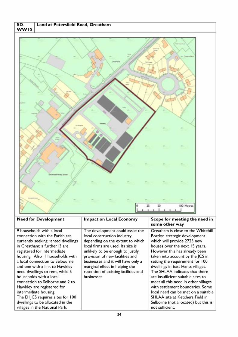
34
SD-
WW10
Land at Petersfield Road, Greatham
Need for Development Impact on Local Economy Scope for meeting the need in
some other way
9 households with a local
connection with the Parish are
currently seeking rented dwellings
in Greatham; a further13 are
registered for intermediate
housing. Also11 households with
a local connection to Selbourne
and one with a link to Hawkley
need dwellings to rent, while 5
households with a local
connection to Selborne and 2 to
Hawkley are registered for
intermediate housing.
The EHJCS requires sites for 100
dwellings to be allocated in the
villages in the National Park.
The development could assist the
local construction industry,
depending on the extent to which
local firms are used. Its size is
unlikely to be enough to justify
provision of new facilities and
businesses and it will have only a
marginal effect in helping the
retention of existing facilities and
businesses.
Greatham is close to the Whitehill
Bordon strategic development
which will provide 2725 new
houses over the next 15 years.
However this has already been
taken into account by the JCS in
setting the requirement for 100
dwellings in East Hants villages.
The SHLAA indicates that there
are insufficient suitable sites to
meet all this need in other villages
with settlement boundaries. Some
local need can be met on a suitable
SHLAA site at Ketchers Field in
Selborne (not allocated) but this is
not sufficient.

35
Detrimental Effects on
Environment / Extent of
Moderation
Detrimental Effects on
Landscape/ Extent of
Moderation
Detrimental Effects on
Recreational Opportunities/
Extent of Moderation
Some archaeology interest, so an
archaeological assessment is
required; mitigation should be
carried out in accordance with its
findings.
Adjacent to (across road from)
Grade II Listed Building and
adjacent to a Conservation Area,
so a heritage statement is
required; mitigation should be
carried out in accordance with its
findings.
Approximately 600m from the
Woolmer Forest SSSI and SAC
which forms part of the Wealden
Heaths Phase II SPA, a site of
international importance for
breeding bird species listed in
Annex 1 of the Birds Directive.
Mitigation in the form of SANGS is
likely to be required in order to
relieve recreational pressure.
Medium Sensitivity.
The size of the site and its location
within the centre of the settlement
makes it more sensitive than
would normally occur for a
developed site.
The site is in a prominent position.
It is well screened behind a mature
hedgerow, although the roofs of
the existing glasshouses can be
seen above this.
There is a public right of way along
south-eastern boundary, but views
of the site are limited.
Development is unlikely to have a
significant detrimental effect on
the experience of using this
footpath.
SANGs could enhance local
recreational provision.
Conclusions
The site is larger than needed to meet local housing needs in Greatham but could also make a contribution to
meeting the local and affordable needs of adjoining parishes, where opportunities are limited for landscape
and other reasons. It could also make a small contribution towards the market housing needs of the wider
HMA, although most of these could be met in nearby Whitehill and Bordon. However the site is required to
help meet the requirements inherited from the EH JCS for 100 dwellings to be allocated in the villages of East
Hants within the National Park, which are over and above the Whitehill and Borden provision. Not all of
these can be found in villages with settlement boundaries elsewhere.
The allocation is in a sustainable location between existing housing and the primary school and near to the
village hall. The size and tenure of housing should be such as to meet local and affordable needs and not those
of commuters using the nearby A3.
In terms of detrimental impacts on the environment, landscape and recreational opportunities, the site itself is
relatively free of major environmental constraints, its landscape impact would be limited and its effect on the
adjoining right of way would be minimal. However its proximity to important European wildlife sites
threatens to have a detrimental impact. Subject to mitigation measures (such as SANGs) to deal with this, and
to a criterion being introduced to the policy to ensure that the tenure and size of housing meets local needs,
it is considered that the tests for exceptional circumstances in the public interest are met.
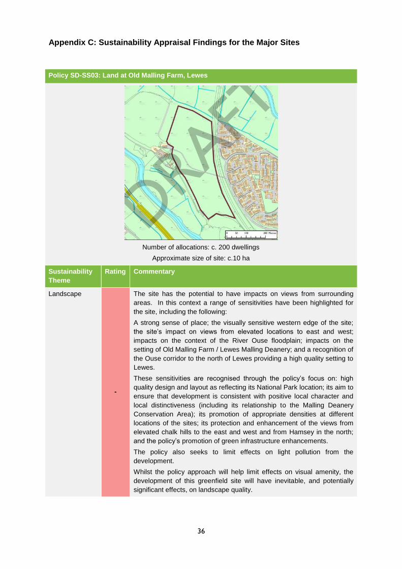
36
Appendix C: Sustainability Appraisal Findings for the Major Sites
Policy SD-SS03: Land at Old Malling Farm, Lewes
Number of allocations: c. 200 dwellings
Approximate size of site: c.10 ha
Sustainability
Theme
Rating Commentary
Landscape
-
The site has the potential to have impacts on views from surrounding
areas. In this context a range of sensitivities have been highlighted for
the site, including the following:
A strong sense of place; the visually sensitive western edge of the site;
the site’s impact on views from elevated locations to east and west;
impacts on the context of the River Ouse floodplain; impacts on the
setting of Old Malling Farm / Lewes Malling Deanery; and a recognition of
the Ouse corridor to the north of Lewes providing a high quality setting to
Lewes.
These sensitivities are recognised through the policy’s focus on: high
quality design and layout as reflecting its National Park location; its aim to
ensure that development is consistent with positive local character and
local distinctiveness (including its relationship to the Malling Deanery
Conservation Area); its promotion of appropriate densities at different
locations of the sites; its protection and enhancement of the views from
elevated chalk hills to the east and west and from Hamsey in the north;
and the policy’s promotion of green infrastructure enhancements.
The policy also seeks to limit effects on light pollution from the
development.
Whilst the policy approach will help limit effects on visual amenity, the
development of this greenfield site will have inevitable, and potentially
significant effects, on landscape quality.

37
Climate Change
Adaptation
?
Whilst the site is not located within a Flood Zone 2 or 3, the susceptibility
of surrounding areas to flooding (including related to the River Ouse)
leads to potential effects from new development at this location on fluvial
and surface water flooding. The policy seeks to address this through
ensuring that a site specific flood risk assessment is undertaken and an
appropriate surface water drainage strategy (including implementation) is
agreed.
Biodiversity
?
The proposed site is located within 200m from the Offham Marshes
SSSI, which is located on the western side of the River Ouse. The two
units of the SSSI located closest to the site have been evaluated to be in
‘favourable’ and ‘unfavourable recovering’ condition.
The site is located within an SSSI Impact Risk Zone for ‘all development’.
As such, development in the region of 200 dwellings raises the possibility
of adverse effects on the Offham Marshes SSSI without avoidance and
mitigation measures.
The disused railway cutting on the east of the site has been designated
as the South Malling Disused Railway SNCI. The northern part of the site
is located on Coastal and Floodplain Grazing Marsh ‘additional’ BAP
Priority Habitat.
The site is located within the Brighton and Lewes Downs Biosphere
Reserve, which is part of a global network of Biosphere Reserves
recognised by UNESCO as ‘special places for testing interdisciplinary
approaches to understanding and managing changes and interactions
between social and ecological systems, including conflict prevention and
management of biodiversity’.
The policy seeks to ensure that ‘appropriate measures are implemented
to mitigate adverse impacts’ on the SNCI and the SSSI and that fields
which are in the same ownership as the site but outside the developable
area, are designated as Local Nature Reserves and/or Local Green
Space, with appropriate management mechanisms put in place. The
policy also seeks to ensure that trees and hedgerows are protected
where appropriate. This will help mitigate potential effects on biodiversity
features and areas of biodiversity value and ecological features in the
area.
Cultural
Heritage
-
Development of 200 dwellings at this site has the potential to have effects
on the Malling Deanery Conservation Area, which is located adjacent to
the site to the south. Five listed buildings are present in the Conservation
Area, including the Grade II* listed Malling Deanery, the Grade II listed
Church of St Michael and the Grade II listed Church Lane Bridge, Malling
Rectory and Gateway to Malling Deanery.
One Grade II listed structure is located at Old Malling Farm (ruins of a
College of Benedictine Canons) to the west of the site.
The policy will help limit potential effects on these features and areas of
historic environmental importance through seeking to ‘ensure that
development respects the character, amenity and setting of the
Conservation Area and the Church of St Michael.’ However, inevitable
effects on the setting of the conservation area and listed buildings are
likely to take place.
The site is located within an area of High Archaeological Potential. This is
recognised by the policy which seeks to ensure that studies are
undertaken to evaluate the archaeological value of the location.

38
Cultural Activity The site is located in good proximity to the cultural services offered by
Lewes. The allocation is unlikely to have significant positive or negative
effects relating to sustainable tourism.
Health and
Wellbeing
+
The site is located approximately 1.3 km from the High Street when
accessed by foot/cycle. It has relatively good access to existing
residential areas and pedestrian and cycle networks- and the policy
seeks to put in place measures to improve access to the site by non-car
modes. As such, the location of the site has potential to promote healthier
modes of travel.
Vitality of
Communities +
The development of 200 dwellings will support the vitality and vibrancy of
Lewes through supporting services, facilities and amenities.
Accessibility
?
The site is located at relative distance (c.1.3km by foot) to the services
and facilities located in Lewes town centre. It is also located
approximately 2.4km to the railway station. This is recognised by the
policy, which seeks to put in place measures to improve access to the
site by non-car modes.
Sustainable
Transport
?
The site is located at relative distance (c.1.3km by foot) to the services
and facilities located in Lewes town centre. It is also located
approximately 2.4km to the railway station. This is recognised by the
policy, which seeks to put in place measures to improve access to the
site by non-car modes.
Housing
+
The site will deliver in the region of c.200 dwellings. The policy states that
50% of these will be affordable. This will contribute to meeting local
housing needs.
Climate Change
Mitigation
?
In terms of greenhouse gas emissions, road transport is an increasingly
significant contributor to emissions locally. The extent to which new
development has the potential to support climate change mitigation
through facilitating a reduced level of car dependency is therefore a key
element. In this context the policy seeks to put in place measures to
improve access to the site by non-car modes.
The development of 200 dwellings at this location will lead to increases in
the built footprint of Lewes, with associated effects on stimulating
additional greenhouse gas emissions. However the preamble for the
policy seeks to ensure that an on-site renewable energy strategy is
required to ensure sustainable zero carbon development is delivered.
Rural Economy
-
Land at the site has been classified as Grade 2 and 3a agricultural land.
This is land classified as the Best and Most Versatile Agricultural Land.
Development at this location will therefore lead to the loss of this land.
Summary of appraisal
Summary: Policy SD-SS03: Land at Old Malling Farm, Lewes
Whilst the policy for the site will help limit potential effects, the development of a 10 ha greenfield site
at this location will lead to inevitable residual effects on landscape quality, the setting of the historic
environment and on land classified as the Best and Most Versatile Agricultural Land. Due to the site’s
location near to a number of designated nature conservation sites, potential negative effects on
biodiversity also have the potential to arise.
Development at this location will lead to the sterilisation of Grade 2 and Grade 3a agricultural land.
This is land classified as the Best and Most Versatile Agricultural Land.
In terms of positive effects, the policy will deliver housing (including affordable housing) which will help

39
meet local needs and support the vitality of Lewes.
Potential significant effects?
Whilst the policy seeks to limit potential negative effects, due to the nature and location of the
development, impacts on landscape quality and visual amenity are likely to be inevitable and
significant.
Significant effects on the Malling Deanery Conservation Area can be avoided if the proposed policy
approaches are implemented effectively and green infrastructure and design improvements are
realised.
The delivering of 200 houses (of which 50% are affordable) will have a significant contribution to
meeting local housing need.
Recommendations
Whilst development at this site has the potential to lead to a number of negative effects, some of
which have the potential to be significant, many of these effects are inevitable given the location and
scale of the development. In this context the current policy promotes an appropriate range of
approaches which will support a limitation of these effects.
Key
Likely adverse effect - Likely positive effect +
Neutral/no effect Uncertain effects ?

40
Policy SD-WW11: Land at Brookland Way, Coldwaltham
Number of allocations: c.20 dwellings
Approximate size of site: c.1 ha
Sustainability
Theme
Rating Commentary
Landscape
?*
The site has been deemed to be of high landscape sensitivity due to the
elevation and openness at the northern extent of the site and along the
public right of way. The site also has a settlement separation function
between Coldwaltham and Watersfield. However the site proposed in
this policy is part of the area which has been evaluated to be of
medium/high sensitivity due to its proximity to Open Access Land.
Whilst the policy seeks to ensure that a Landscape and Visual Impact
Assessment is undertaken to inform design and layout and careful
consideration is given to the boundary treatment of the site, due to the
sensitivity of the site, potential effects are on landscape quality may still
arise.
Climate Change
Adaptation
The site is not located within an area at risk of fluvial, surface water or
groundwater flooding.
Biodiversity
?
The site is located within 50m of the Waltham Brooks SSSI, which has
been evaluated as being in an ‘unfavourable recovering’ condition. The
site is within the SSSI’s Impact Risk Zone for the type of development
proposed (the site is within an Impact Risk Zone for ‘All planning
applications outside/extending outside existing settlements/urban areas
affecting greenspace, farmland, semi natural habitats or features such as
trees, hedges, streams, rural buildings/structures’). The part of the SSSI
on the far side of the railway line (approximately 100m distant) has been
designated as the Arun Valley SPA and Ramsar site. The Arun Valley
SAC is also located slightly further south. The Waltham Brooks has also
been designated as a Local Nature Reserve. The site is 3.8km from
Duncton to Bignor Escarpment SAC and 2.6km from The Mens SAC
As such, allocation of c.20 units at this location raises the possibility of
adverse effects on these sites without appropriate avoidance and
mitigation measures. The policy approach for the allocation only
highlights that an ‘appropriate ecological survey will be required’. In this
41
context there is further scope for additional approaches to be included to
ensure that potential effects are avoided in the first instance.
Cultural
Heritage
The Grade II listed Widneys, situated on Brook Lane, is located in the
vicinity of the site. The building is however well screened from the site,
with a number of houses located between.
Cultural Activity The allocation is unlikely to have significant positive or negative effects
relating to sustainable tourism.
Health and
Wellbeing
No significant effects at this level of detail.
Vitality of
Communities +
The development of c.20 dwellings will support the vitality and vibrancy of
Coldwaltham through supporting services, facilities and amenities.
Accessibility
+
The site is accessible to existing village facilities and amenities, including
the school and pub. The site is also, due to its relative proximity to
Pulborough, accessible to the range of services, facilities and amenities
located in this nearby large village. However, bus links between the two
settlements are poor.
Sustainable
Transport ?
The site has good accessibility to the school due to its close proximity.
However, the site has poor accessibility to the services, facilities and
amenities located in Pulborough by bus.
Housing +
The site will deliver 20 dwellings. This will contribute to meeting local
housing needs.
Climate Change
Mitigation ?
The development of 20 dwellings at this location will lead to increases in
the built footprint of Coldwaltham. However, given the amount of housing
proposed for this site it is not anticipated that associated effects on
greenhouse gas emissions will be significant.
Rural Economy
+
Through increasing local housing stock, the delivery of housing at this
site has the potential to support the village’s vitality (although this will be
limited by the proposed size of the allocation).
Summary of appraisal
Summary: Policy SD-WW11: Land at Brookland Way, Coldwaltham
The proposed allocation is located within an area of significant ecological sensitivity, with Waltham
Brooks SSSI and the Arun Valley SPA and Ramsar site present locally. The proposed approach to
the protection of biodiversity assets is unlikely to be sufficient to ensure that potential effects on the
nature conservation value of these sites are avoided.
The site is accessible to existing village facilities and amenities, including the school and pub. The site
is also, due to its relative proximity to Pulborough, accessible to the range of services, facilities and
amenities located in this nearby large village. However, bus links between the two settlements are
poor. This has the potential to encourage the use of the private car.
The allocation is unlikely to have significant effects on landscape quality or the historic environment.
Potential significant effects?
Due to the presence of nationally and internationally designated nature conservation sites locally,
effects have the potential to be significant if the proposed policy approach to the protection and
enhancement of biodiversity value is not made more robust.
Recommendations
There is additional scope for the policy to propose specific approaches which seek to avoid effects on
the Waltham Brooks SSSI and the Arun Valley SPA and Ramsar site.

42
Policy SD-WW10: Land at Petersfield Road, Greatham
Number of allocations: c.30 dwellings
Approximate size of site: c.2.4 ha
Sustainability
Theme
Rating Commentary
Landscape
?
Whilst the site is located on previously developed land, the site has
been established as having medium landscape sensitivity due to the
size of the site and its location within the centre of the settlement.
The proposed policy notes that a Landscape and Visual Impact
Assessment will be required and the retention of existing hedgerows
and careful consideration is given to the boundary treatment of the site.
It also highlights that a Heritage Statement should be prepared. Given
the disused glasshouses currently on site development has the scope
to enhance landscape character.
Climate Change
Adaptation
The site is not located within an area at risk of fluvial, surface water or
groundwater flooding.
Biodiversity
?
The site is located approximately 600m from the Wealden Heaths
Phase II SPA. The SPA is covered by the Woolmer Forest SSSI and is
situated within an SSSI Impact Risk Zone for the types of development
proposed (‘any residential developments with a total net gain in
residential units’). These constraints are acknowledged by the policy,
which states ‘advice from Natural England will be required on
appropriate measures to mitigate the impacts of recreational
disturbance’.
The site is not located adjacent to areas of BAP Priority Habitat.
The policy seeks to ensure that new development supports the aims of
the Rother Valley Biodiversity Opportunity Area, within which the site is
located.

43
Cultural Heritage
?
The Grade II listed Deal Farmhouse is located on the opposite side of
Petersfield Road from the site, and the site is located within an area of
archaeological interest. This is recognised by the policy, which seeks to
ensure that a Heritage Statement is prepared and a pre-application
archaeological assessment is undertaken.
Cultural Activity No significant effects are anticipated.
Health and
Wellbeing
No significant effects are anticipated.
Vitality of
Communities +
The development of c.30 dwellings will support the vitality and vibrancy
of Greatham through supporting services, facilities and amenities.
Accessibility
+
The site is accessible to existing village facilities and amenities,
including the school, village hall, pub and sports/recreational facilities.
The site is also, due to its relative proximity to Liss (c.3km), accessible
to the range of services, facilities and amenities located in this nearby
larger village and the railway station. However, bus links between the
two settlements are limited to a two hourly service during the day.
Sustainable
Transport ?
Whilst the site is located close to an existing bus link, this is limited to a
two hourly service. The site is located 3km from Liss railway station.
Housing +
The delivery of approximately 30 dwellings on this site would help
contribute towards meeting local demand for housing.
Climate Change
Mitigation -
The development of approximately 30 dwellings at this location will lead
to increases in the built footprint of Greatham- however, given the
amount of housing proposed for this site it is not anticipated that
associated effects on greenhouse gas emissions will be significant.
Rural Economy
+
Through increasing local housing stock, the delivery of housing at this
site has the potential to support the village’s vitality.
The site is located in a Mineral Consultation Area, which is
acknowledged through the policy.
Summary of appraisal
Summary: Policy SD-WW10: Land at Petersfield Road, Greatham
The location of the site close to Wealden Heaths Phase II SPA and within the SSSI Impact Risk Zone
for the Woolmer Forest SSSI is a significant constraint facing the site. This is recognised the policy,
which highlights that consultation with Natural England will be required. Effects on local historic
environment assets and archaeology of the site will be limited by the proposed policy approach.
The development of 30 dwellings at the site will help meet local housing needs and support the vitality
of the local area. The site is also accessible to village amenities, and relatively accessible to Liss by
bus.
The site is located in a Mineral Consultation Area, which is acknowledged through the policy.
Potential significant effects?
Due to the presence of nationally and internationally designated nature conservation sites locally,
effects on biodiversity have the potential to be significant if the proposed policy approach to the
protection and enhancement of biodiversity value is not effectively implemented.
Recommendations
None proposed.