Embed Size (px)
Citation preview

Prof. Richard Bush The International Centre for Balanced Land Use Dr. Thava Palanisami The University of Newcastle Dr. Zhaohui Wang Callaghan 2308, NSW
ASSESSMENT OF METALS AND METALLOIDS IN SURFACE WATER DISCHARGED FROM UPPER HUNTER COAL MINES AND POWER STATIONS

Acknowledgements
The project team gratefully acknowledge the support of UHMD Water Quality study
steering committee for the clarification of sampling/methodological issues and/or
contributions to reviewing and discussing various components of the report.
Steering Committee
• Mr. Mitchell Bennett, NSW Environment Protection Authority
• Mr. Domnic Brown, Environmental Specialist-Operations, Rio Tinto
• Mr. John Watson, Environment and Climate Change Manager, Glencore
• Mr. Matthew Parkinson, Environmental Business Partner, AGL Macquarie
• Mr. Ken Bray, Hunter Valley Water Users Association
• Prof. Richard Bush, The University of Newcastle
• Dr. Thava Palanisami, The University of Newcastle
Industry Support: Representatives from the following organisations provided essential
support in the collection of archive data and field sampling: Rio Tinto, Glencore, AGL,
Bengalla.
Submission to the Upper Hunter Mining Dialogue The International Centre for Balanced Land Use
The University of Newcastle
Callaghan 2308, NSW
March 2018
Disclaimer: This report is provided for the dissemination of information relating to scientific and technical matters. The University of Newcastle does not accept liability for any loss and/or damage, including financial loss, resulting from the reliance upon any information, advice or recommendations contained in this publication. The contents of this publication should not necessarily be taken to represent the views of the participating organizations.

Executive Summary
The Hunter Region supports a range of primary and resource based industries that
include agriculture, energy generation, mining and tourism. Due to the unique geology and
soil landscapes, the Hunter Valley has a natural abundance of salts that partially leach into
ground water and rivers. As part of the regular coal mining process, saline waters collect
in mine pits and shafts and must be pumped out. Power generation from the thermal coal
plants at Bayswater and Liddell in the Upper Hunter rely on cooling via evaporative loss
of water, a process that leads to the concentration of salts in the residual dam water in Lake
Liddell. The management of excess salt water is challenging for these industries.
In the 1990’s the Hunter River Salinity Trading Scheme (HRSTS) was developed
through collaboration with the community, industry and government, as a water
management strategy aimed at minimizing the cumulative impact of mining and energy
generation on the Hunter River water quality to reduce salinity levels. The scheme
essentially coordinates the discharge of excess water from mine sites and the AGL power
stations, to coincide with high river flow conditions, to cap the maximum salt
concentrations within an environmentally acceptable range, while still enabling the
discharge of salt that has accumulated through industrial activities. The operation of
HRSTS is widely regarded as a successful strategy, with data demonstrating water quality
improvements in terms of salinity over the 23 years of operation. Despite rigorous
assessment of salinity levels in relation to this scheme, other aspects of water quality, such
as metal(loid)s, have not been a focus of monitoring and assessment and very little data
exists on these aspects within the HRSTS.
The International Centre for Balanced Land use has been commissioned by the Upper
Hunter Mining Dialogue to conduct a preliminary investigation on metal(loid)s across key
storage dams within the HRSTS that intercept water from coal mines and power utilities
operating in the Upper Hunter. Metal(loid) concentrations in the discharge water storage
dams were compared against multiple reference sites representative of conditions in the
Upper Hunter River affected by the HRSTS. Furthermore, the ANZECC (2000) national
water quality guidelines were used as a filter to identify potential issues pollution issues
associated with mine water discharge. The key findings and conclusions of this study are
listed below:
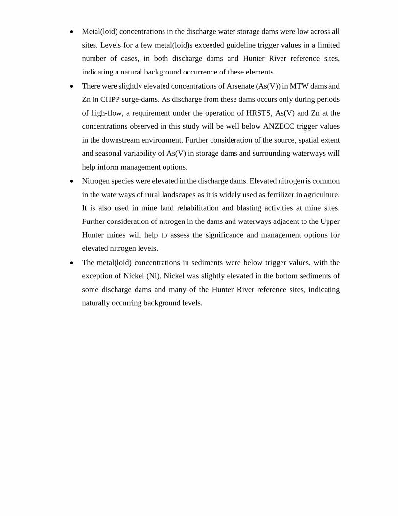
• Metal(loid) concentrations in the discharge water storage dams were low across all
sites. Levels for a few metal(loid)s exceeded guideline trigger values in a limited
number of cases, in both discharge dams and Hunter River reference sites,
indicating a natural background occurrence of these elements.
• There were slightly elevated concentrations of Arsenate (As(V)) in MTW dams and
Zn in CHPP surge-dams. As discharge from these dams occurs only during periods
of high-flow, a requirement under the operation of HRSTS, As(V) and Zn at the
concentrations observed in this study will be well below ANZECC trigger values
in the downstream environment. Further consideration of the source, spatial extent
and seasonal variability of As(V) in storage dams and surrounding waterways will
help inform management options.
• Nitrogen species were elevated in the discharge dams. Elevated nitrogen is common
in the waterways of rural landscapes as it is widely used as fertilizer in agriculture.
It is also used in mine land rehabilitation and blasting activities at mine sites.
Further consideration of nitrogen in the dams and waterways adjacent to the Upper
Hunter mines will help to assess the significance and management options for
elevated nitrogen levels.
• The metal(loid) concentrations in sediments were below trigger values, with the
exception of Nickel (Ni). Nickel was slightly elevated in the bottom sediments of
some discharge dams and many of the Hunter River reference sites, indicating
naturally occurring background levels.
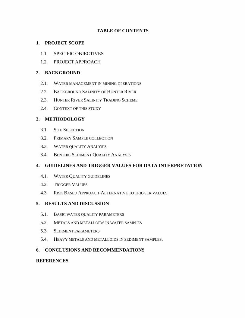
TABLE OF CONTENTS
1. PROJECT SCOPE
1.1. SPECIFIC OBJECTIVES
1.2. PROJECT APPROACH
2. BACKGROUND
2.1. WATER MANAGEMENT IN MINING OPERATIONS
2.2. BACKGROUND SALINITY OF HUNTER RIVER
2.3. HUNTER RIVER SALINITY TRADING SCHEME
2.4. CONTEXT OF THIS STUDY
3. METHODOLOGY
3.1. SITE SELECTION
3.2. PRIMARY SAMPLE COLLECTION
3.3. WATER QUALITY ANALYSIS
3.4. BENTHIC SEDIMENT QUALITY ANALYSIS
4. GUIDELINES AND TRIGGER VALUES FOR DATA INTERPRETATION
4.1. WATER QUALITY GUIDELINES
4.2. TRIGGER VALUES
4.3. RISK BASED APPROACH-ALTERNATIVE TO TRIGGER VALUES
5. RESULTS AND DISCUSSION
5.1. BASIC WATER QUALITY PARAMETERS
5.2. METALS AND METALLOIDS IN WATER SAMPLES
5.3. SEDIMENT PARAMETERS
5.4. HEAVY METALS AND METALLOIDS IN SEDIMENT SAMPLES.
6. CONCLUSIONS AND RECOMMENDATIONS
REFERENCES

1. PROJECT SCOPE
To assess the potential for metal(loid) contamination of the Hunter River through the
discharge of mine water under the Hunter River Salinity Trading Scheme.
1.1. SPECIFIC OBJECTIVES
Key objectives:
1) Quantify metal(loid)s in surface waters and benthic sediments in water storage dams
that are used as part of the key infrastructure within the Hunter River Salinity Trading
Scheme.
2) Evaluate the potential for metal(loid) contamination of the Hunter River through the
Hunter River Salinity Trading Scheme.
1.2. PROJECT APPROACH
The project approach involves two broader tasks:
Task 1 - Assessment of metal(loid) concentrations against water quality guidelines in the
surface water and benthic sediments in coal discharge water storages.
Task 2 - Information from Task 1 will be combined to provide a preliminary risk
assessment for contamination of the Hunter River by metal(loid)s from coal operations
and electricity generators in the Upper Hunter

2. BACKGROUND
Australia has been a major mining nation for more than 150 years. Wastewater from the
extraction and refinement of coal may be discharged to the environment, through both
planned and unplanned releases. Discharges are often saline and may contain dissolved
solids, suspended solids, heavy metals, hydrocarbons and other compounds.
The Hunter River Salinity Trading Scheme (HRSTS) was developed in the 1990’s
as a regulatory strategy to minimize the cumulative impacts of coal mining on the water
quality of the Hunter River to reduce maximum salinity levels. The scheme coordinates the
discharge of excess water from mine sites to coincide with high-flow conditions in the
Hunter River, in an effort to cap salt concentrations within an environmentally acceptable
range. The capacity to store water and manage discharges against real-time flow conditions
are the defining features of this scheme, which has proven effective in managing salinity
in the Hunter River. Further information about HRSTS is publically available at:
http://www.epa.nsw.gov.au/licensing-and-regulation/licensing/environment-protection-
licences/emissions-trading/hunter-river-salinity-trading-scheme
Nutrients, suspended sediments, algae, organic and inorganic compounds, heavy
metals and metalloids, and bacteria are other potential factors that can affect water quality.
Metal(loid)s, hydrocarbons, salinity and acidity are common potential contaminants
associated with mining activities. Technologies and approaches to protect water resources
from contamination by either reducing, containing or treating contamination is core
business for the industry and closely regulated by licensing authorities (e.g. Government
Environmental Protection Agencies).
2.1.WATER MANAGEMENT IN COAL MINING OPERATIONS Saline water discharged under the HRSTS is derived from the Hunter coal-fields (mainly
groundwater) and from the evaporative-concentration of river water that has been used for
power generation. The quality of mine water can vary due to its contact with coal, coal
tailings, overburden and variability in geology of the mine catchment itself [3].
The coal mining industry consumes a relatively small quantity of water at national
and global levels. Mining accounted for 4% of the water used in Canada, 2-3% of the total
water consumed in Australia and 1% in the United States during 2005 [3, 4, 5].

Most coal mine waste is inert or benign, and therefore represents a low
contamination risk to waterways when managed appropriately [1]. In some cases, mine
waters can be high enough in quality that they require little treatment before being released
to the environment. Shibdon Pond in England, for example, is an abandoned coal mine
which has supported the development of a wetland and is now home to a sustainable
ecosystem [7]. Treated mine water has many practical applications including augmentation
to drinking water supplies and agricultural irrigation [8, 9].
Nevertheless, in some circumstances, mine water has the potential to affect the
quality of surrounding surface waters and ground waters, which can impact on the
environment. Water contaminated with high concentrations of metals, sulfide minerals,
dissolved solids and/or salts can negatively affect the quality of surface waters, ground
waters and aquatic ecosystems [11]. Therefore, the modern mining industry endeavors to
recycles any waste and water resources. Advanced water management practices and mine
designs have greatly reduced the potential for water contamination associated with mine
sites over the past couple of decades. Waters are frequently monitored and comprehensive
water management strategies have been developed to reduce the amount of mine water
produced, with treatment to regulatory requirements (when necessary) before discharge to
the environment a standard industry practice.
2.2. BACKGROUND SALINITY OF HUNTER RIVER The Hunter River catchment drains an area of approximately 22,000 square kilometres on
the central NSW coast. The valley comprises rugged mountain ranges in the north,
undulating farmland in the central and western regions, and widespread fluvial/estuarine
flatland coastal areas to the east. There are a variety of potential sources of salinity in the
Hunter River catchment that include atmospheric deposition, run-off and infiltration,
weathering of geological strata, groundwater and a range of anthropogenic sources. The
Hunter Valley is generally saline due to the marine origin of some Permian sediments.
However, recent land-use activities in the catchment may have contributed to rising
salinity in streams such as the Goulburn River and Wollombi Brook. The Goulburn River
tributary sub-catchment contributes higher salinity water to the Hunter River and this
source of salts is outside (and upstream) of the HRSTS.

In a study of the salt inputs into the Hunter Valley catchments, Creelman (1994)
suggested that rainfall released salts from weathered rocks and mine overburden. Kellet et
al. (1989) found that input of groundwater from the Wittingham coal measures (in the mid-
lower Hunter) was also of significance in terms of salinity contribution to the Hunter River
catchment. The authors concluded that, of all the potential salt sources, regional geology
was the dominant factor controlling the chemistry of Upper Hunter Valley groundwater
and was the primary source of high background salinity in groundwater of the mid valley
(e.g. Jerrys Plains and surrounds).
Overlaying the natural saline landscape in the Hunter River catchment are
anthropogenic activities that can enhance salinity levels: mining, power generation and
agriculture. These activities can either remove salts from the river system (e.g. via water
extractions) or introduce them into the system (via licensed discharges and/or land run-
off). The multiplicity of salt sources and the highly variable spatial and temporal
interaction of natural and anthropogenic sources of salt create a complex challenge for
managing salinity in the Hunter River catchment.
2.3. Hunter River Salinity Trading Scheme
The Hunter River Salinity Trading Scheme (HRSTS) operates to minimise the impact of
saline waters discharged from industry to the Hunter River. The Scheme commenced as a
pilot in 1995 and was formalised in 2002 under the Protection of the Environment
Operations (Hunter River Salinity Trading Scheme) Regulation (2002). The Scheme’s
salinity targets apply only in the Hunter River between Glenbawn Dam at the upstream
extent, and Singleton at the downstream extent, and only on the main channel of the Hunter
River (i.e. not within any of the Hunter River tributaries).
River salinity targets have been established for three reference points in each of
the River sectors (upper, middle and lower). Denman is the reference point for the upper
sector; upstream of the Glennies Creek confluence for the middle sector; and Singleton
for the lower sector (See Fig 1). The total allowable discharge of water and salt from
participating mines and the power station is calculated so that salt concentration does not
exceed 900 electrical conductivity units (EC) in the middle and lower sectors of the river,
or 600 EC in the upper sector.

A recent review of the overall effectiveness of the HRSTS on surface water by the
NSW Environmental Protection Agency reports:
• Little effect on flows and EC levels in the Hunter River upstream of Denman;
• Reduced EC levels at (and immediately upstream of) Singleton and Greta; and
• Potentially reduced EC levels at monitoring stations between Denman and Singleton
Based on these observations, the review concluded the HRSTS is achieving the overall
goal of managing waters discharged to the Hunter River from mines and power
generation.
2.4.CONTEXT OF THIS STUDY
Salinity, hydrocarbons, heavy metals and acidity are common potential contaminants
associated with mining. Contamination can result from uncontrolled water discharges from
mine sites, increased salinity in mine discharges and the formation of acid mine drainage
(AMD) or alkaline waters on site due to the mineral specific composition, specific ore and
overburden [2]. Technologies and approaches to protect water resources from
contamination by either reducing, containing or treating contamination is core business for
the mining industry and closely regulated by licensing authorities.
Among 29 coal mines that currently operate in the Hunter Valley, 10 are entitled to
discharge under the HRSTS scheme. Although there is a large dataset on salinity contents
in surface waters entering the Hunter River from mining [NSW EPA personal
communication], there is limited information on the contents of metal(loids). Unlike other
coal mine regions in Australia, at this stage heavy metals have not been identified as major
water quality parameters of concern associated with coal mining in the Upper Hunter [8].
The Upper Hunter Mining Dialogue commissioned The University of Newcastle to
conduct a preliminary screening for metal(loids) in discharge dams managed as part of the
HRSTS. This preliminary investigation provides a snapshot of water quality data to screen
for potential issues and inform the on-going management of the HRSTS.
3. METHODOLOGY
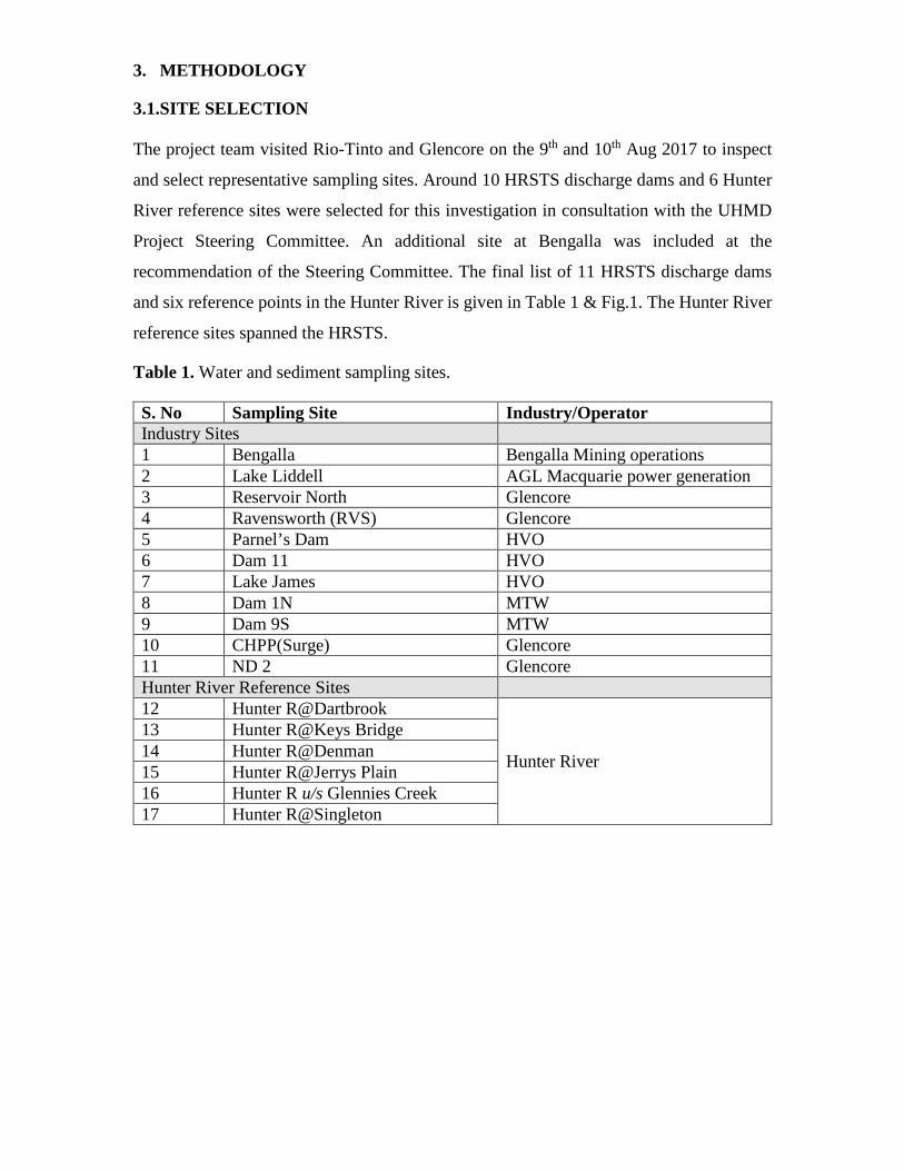
3.1.SITE SELECTION
The project team visited Rio-Tinto and Glencore on the 9th and 10th Aug 2017 to inspect
and select representative sampling sites. Around 10 HRSTS discharge dams and 6 Hunter
River reference sites were selected for this investigation in consultation with the UHMD
Project Steering Committee. An additional site at Bengalla was included at the
recommendation of the Steering Committee. The final list of 11 HRSTS discharge dams
and six reference points in the Hunter River is given in Table 1 & Fig.1. The Hunter River
reference sites spanned the HRSTS.
Table 1. Water and sediment sampling sites.
S. No Sampling Site Industry/Operator Industry Sites 1 Bengalla Bengalla Mining operations 2 Lake Liddell AGL Macquarie power generation 3 Reservoir North Glencore 4 Ravensworth (RVS) Glencore 5 Parnel’s Dam HVO 6 Dam 11 HVO 7 Lake James HVO 8 Dam 1N MTW 9 Dam 9S MTW 10 CHPP(Surge) Glencore 11 ND 2 Glencore Hunter River Reference Sites 12 Hunter R@Dartbrook
Hunter River
13 Hunter R@Keys Bridge 14 Hunter R@Denman 15 Hunter R@Jerrys Plain 16 Hunter R u/s Glennies Creek 17 Hunter R@Singleton

Figure 1. Sampling locations across the Hunter River Salinity Trading Scheme.

3.2. PRIMARY SAMPLE COLLECTION To capture a snapshot of water and sediment quality to meet the objectives of this study, a one-off
round of sampling was undertaken by qualified staff. Site access, staff induction and sampling
logistics were undertaken in close consultation with mine operators, assuring compliance with
Work Health & Safety requirements at each sampling location. Although outside the preliminary
screening purpose of this study, it is important to note that water, sediment quality in the discharge
dams may vary over time, and temporal variability was not accounted for by this study.
Figure.2. Schematic of the sampling approach
A total of 17 locations were sampled over a 10 day fieldwork campaign. Duplicate samples of
water were collected at 2/3 the water-depth using sterile containers. This is a standard approach
for normalizing the potential effects of stratified water chemistry. Samples were immediately
filtered through a 0.45-micron filter paper to remove particulates, chilled and delivered to the
laboratory to minimise sample degradation. Unstable sediment parameters (e.g.; pH, temperature,
dissolved oxygen, redox and turbidity) were recorded in the field.
Water samples
125ml portion of the sample filtered (0.45um) & acidified
1 L non-acidified water
Samples will be taken 2/3 depth of the water column; on spot water quality analysis using multi-probe
Sediment samples
Samples will be taken from benthic region; on spot sediment quality assessment (pH & Eh)
Packed in 1 kg glass jar
to the rim

A composite sample from the upper 10cm layer of benthic sediment was collected using a van
Veen grab sampler or push-corer. Chemical parameters were measured by Environmental
Analysis Laboratory (EAL), a NATA (National Association of Testing Authorities) accredited
laboratory (Lab. Acc. No. 14960).
3.2.WATER QUALITY ANALYSIS
For this investigation, water samples were tested for a comprehensive array of parameters.
These parameters provide sufficient information to assess water geochemistry and quality. Table.2. Water quality parameters included in this study Parameters Target compounds
General water quality parameters pH
Conductivity
Total Suspended Solids (TSS)
Biochemical Oxygen Demand (BOD)
Total Nitrogen (TN)
Total Phosphorus (TP)
Alkalinity (Bicarbonate)
Carbon-Dissolved Organic (DOC)
Heavy metals Copper, Lead, Cadmium, Zinc, Arsenic, Selenium,
Iron, Manganese, Silver,
Chromium, Nickel, Aluminium, Mercury, Sodium,
Potassium, Calcium, Magnesium,
Chloride, Sulfur, Phosphorus, Boron, Barium, Cobalt,
Molybdenum, Vanadium,
Bromide and Silicon
Heavy metal speciation Chromium VI – Hexavalent
Total Arsenic, Arsenic(V) & (III)
Nutrients Nitrate, Nitrite, Phosphate, Ammonium

3.3. BENTHIC SEDIMENT QUALITY ANALYSIS Benthic sediment samples were analysed to understand the accumulation and potential for
mobilisation of metals to the Hunter River (Table 3).
Table.3. Sediment quality parameters focused in this study
Parameters Target Compounds
General sediment quality analysis pH and EC(1:5)
Basic colour and texture
Nutrients Total Carbon (TC), Total Nitrogen (TN),
Organic Matter, TC/TN Ratio
Available Nutrients Calcium, Magnesium, Potassium,
Ammonium, Nitrate, Phosphate, Sulfur
Exchangeable Nutrients Sodium, Potassium, Calcium,
Magnesium, Hydrogen, Aluminium, Cation
Exchange Capacity
Available Micronutrients Zinc, Manganese, Iron,
Copper, Boron, Silicon
Heavy metals Silver, Arsenic,
Lead, Chromium, Nickel, Cadmium, Mercury
Total elemental analysis Sodium, Potassium, Calcium,
Magnesium, Sulfur, Phosphorus, Silicon,
Cobalt, Molybdenum, Selenium, Zinc,
Manganese, Iron, Copper, Boron and
Aluminium

4. GUIDELINES AND TRIGGER VALUES FOR DATA INTERPRETATION
4.1.WATER QUALITY GUIDELINES
Water quality guidelines provide numerical concentration limits, or narrative statements,
recommended to support and maintain a designated water use (i.e. drinking water, irrigation,
stock and domestic water, environmental and ecological). The Australian and New Zealand
Environment Conservation Council (ANZECC) published the revised Australian and New
Zealand guidelines for fresh and marine water quality in 2000, which are available at
www.deh.gov.au/water/quality/nwqms. The ANZECC guidelines provide the government and
community – particularly regulators, industry, consultants, community groups and catchment
and water managers – with a framework for assessing water with a purpose of conserving
ambient water quality in rivers, lakes, estuaries and marine waters.
Water quality parameters can be divided into those with potential direct toxic effects
on organisms and animals (e.g. insecticides, herbicides, heavy metals and temperature) and
those which may indirectly affect ecosystems and impact specified environmental values (e.g.
nutrients, turbidity and enrichment with organic matter). Whether the effects are direct or
indirect, they can have important implications for management options, and for how a
guideline ‘trigger’ value might be set.
Exceedance of the guidelines indicates that there is potential for an impact to occur (or
to have occurred), but does not provide any certainty that an impact will occur (or has
occurred). It is important to understand that guidelines and thresholds act only to identify
potential issues, and generally identify the need for more detailed studies to quantify risk for
impacts that incorporate site specific moderating factors, such as spatial scale, sensitivity of
the environment and compounding effects of multiple environmental stressors.
The ANZECC guidelines offer three levels of protection, each tied to ecosystem
condition. Level 2 “slightly to moderately disturbed ecosystems’ and Level 3 “highly disturbed
ecosystems” are appropriate for waterways within the HRSTS. For highly disturbed
ecosystems that cannot feasibly be returned to a slight/moderately disturbed condition, the
Guidelines provide advice to assist managers to derive alternative guidelines that give lower

levels of protection. The level of protection applied to most waterways in NSW rural and
regional areas is “slightly to moderately disturbed ecosystems’ (Level 2).
4.2.TRIGGER VALUES
ANZECC guidelines use ‘trigger values’ to indicate a potential water and sediment quality
contamination issue (Table 4 & 5). Trigger values are set as conservative assessment values,
and according to the guidelines, should not be considered as a pass/fail compliance criterion.
Local environmental conditions vary naturally between waterways and it may be necessary to
fine-tune trigger values (to higher or lower threshold values) to better correlate with local
conditions. The guidelines provide a process for refining the trigger values and the below
protocols should be followed.
Where an indicator is below the threshold value or within the desirable range for in a
waterway, the risk to the protection of the environment is low (Fig.3).
Where an indicator is higher than the threshold value or outside the desirable range for its
trigger value in a waterway, there may be a risk that environmental values will not be protected.
This may ‘trigger’ either:
− Immediate action to address the likely causes of the value not being met, or
Figure.3. ANZEC trigger value with a threshold

− Further investigations to determine whether the trigger value is inappropriately too
conservative for local conditions, or that local conditions are impacting ambient levels
and toxicity of the contaminant is concerning.
4.3.RISK BASED APPROACH-ALTERNATIVE TO TRIGGER VALUES
In some cases, trigger values will not be appropriate and it will be necessary to investigate
further to refine trigger values that take into account specific localised conditions (Table 5
ANZECC Guidelines). In such cases, the ANZECC guidelines advocate a ‘risk-based’
approach. This means that any investigation into the cause of a water-quality problem reflects
the level of risk associated with it.
A more comprehensive assessment is required where there is a higher likelihood, or
greater consequence of an issue or activity having a negative impact on environmental values.
The risk will vary depending on the nature and location of a land use, whether it is being carried
out in a satisfactory manner, and the sensitivity of the local waterway. The judgement of the
level of risk requires case-by-case interpretation in most situations, with many activities falling
somewhere in between very low and very high risk.
4.4.INTERPRETATION OF ANZECC GUIDELINES IN THE HRSTS AND UPPER HUNTER MINES
The ANZEC guidelines and associated trigger values are not directly applicable to the
discharge dams used in the HRSTS. The ANZECC framework is particularly relevant for
conserving ambient water quality in rivers, lakes, estuaries and marine waters. Therefore,
trigger values do not translate directly to discharge dams. This study used the ANZECC
framework as a screening-filter only, to identify any potential water quality issues. In addition
to ANZECC trigger values, the water and sediment quality is compared against Hunter River
reference sites to provide a practical interpretation.
It is important also to note that a trigger value is not applied for total arsenic under
current ANZECC guidelines. Therefore, in this study a total As value was considered against
the irrigation water guidance value of 0.05 mg/L.
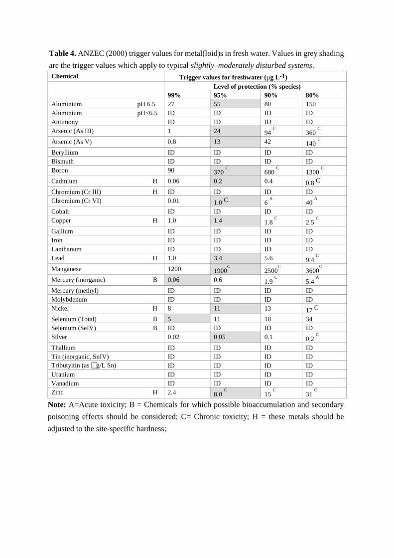
Table 4. ANZEC (2000) trigger values for metal(loid)s in fresh water. Values in grey shading are the trigger values which apply to typical slightly–moderately disturbed systems.
Note: A=Acute toxicity; B = Chemicals for which possible bioaccumulation and secondary poisoning effects should be considered; C= Chronic toxicity; H = these metals should be adjusted to the site-specific hardness;
Chemical Trigger values for freshwater (µg L-1) Level of protection (% species) 99% 95% 90% 80%
Aluminium pH 6.5 27 55 80 150 Aluminium pH<6.5 ID ID ID ID Antimony ID ID ID ID Arsenic (As III) 1 24 94
C 360
C
Arsenic (As V) 0.8 13 42 140 C
Beryllium ID ID ID ID Bismuth ID ID ID ID Boron 90 370
C 680
C 1300
C
Cadmium H 0.06 0.2 0.4 0.8 C Chromium (Cr III) H ID ID ID ID Chromium (Cr VI) 0.01 1.0 C 6
A 40 A
Cobalt ID ID ID ID Copper H 1.0 1.4 1.8
C 2.5
C
Gallium ID ID ID ID Iron ID ID ID ID Lanthanum ID ID ID ID Lead H 1.0 3.4 5.6 9.4
C
Manganese 1200 1900C 2500
C 3600
C
Mercury (inorganic) B 0.06 0.6 1.9 C 5.4
A
Mercury (methyl) ID ID ID ID Molybdenum ID ID ID ID Nickel H 8 11 13 17 C Selenium (Total) B 5 11 18 34 Selenium (SeIV) B ID ID ID ID Silver 0.02 0.05 0.1 0.2
C
Thallium ID ID ID ID Tin (inorganic, SnIV) ID ID ID ID Tributyltin (as g/L Sn) ID ID ID ID Uranium ID ID ID ID Vanadium ID ID ID ID Zinc H 2.4 8.0
C 15
C 31
C

Table 5. ANZEC (2000) recommended sediment quality guidelines for metal(loid)s
Contaminant ISQG-Low
(Trigger value)
ISQG-High
METALS (mg/kg dry wt)
Antimony 2 25
Cadmium 1.5 10
Chromium 80 370
Copper 65 270
Lead 50 220
Mercury 0.15 1
Nickel 21 52
Silver 1 3.7
Zinc 200 410
METALLOIDS (mg/kg dry wt)
Arsenic 20 70

5. RESULTS AND DISCUSSION
5.1. BASIC WATER QUALITY PARAMETERS
Water quality data for the discharge dams is presented in Table.6. The pH is slightly alkaline,
ranging from 8.5 - 9. Electrical conductivity (EC), the common measure for salinity, was
elevated as expected, reaching a maximum of 9.45 ds/m in Dam 9S at the Mount Thorley
Warkworth (MTW) mine site. Generally, the salinity, as measured by EC, is above the
freshwater salinity range. The concentration of inorganic salts which include calcium,
bicarbonate, nitrogen, phosphorus, iron and sulfur, follow the EC trend of the storage dams.
The pH of the Hunter River reference sites was also slightly alkaline (Table.7), with pH
increasing progressively downstream, from (pH 8.03) at the upper extent of Dart Brook, to pH
8.63 at Singleton. EC of the reference samples were < 2 dS/m. Overall, the reference sites are
within the prescribed range in the ANZECC lowland river guidelines (pH 6.5-9.0).
Nutrient concentrations varied widely among storage dams. The total nitrogen and
nitrate-nitrogen were elevated in the mine site discharge dams. The trend for ammonia-nitrogen
differed to TN and NO3, suggesting that most of the ammonia-nitrogen has come from oxidized
nitrates. Total phosphorus concentrations in the discharge dams was low and similar to the
concentrations observed at the Hunter River reference sites.
Nitrogen chemistry in natural settings is complex, with numerous chemical and
biological reaction paths and compounds involved with the cycling of this essential nutrient.
In the Australian context, rivers and other waterways tend to be naturally nitrogen-poor.
Interestingly, nutrient concentrations at Lake Liddell, which receives water from the Hunter
River, also has low nitrogen contents. There are several possible sources of nitrogen at mine
sites that include:
• Geological nitrogen released during the blasting and excavation process;
• Pit water and the use of ammonium-nitrate explosives;
• Various disposal facilities, such as pollution control dams, rock dumps, tailings dams,
etc.; and
• Different industrial nitrogen-containing chemicals used in minerals processing,

including nitric acid (HNO3), ammonium-chloride (NH4Cl) and ammonium hydroxide
(NH4OH).
Elevated nitrogen concentration in mine water has been reported internationally and attributed
to land rehabilitation, erosion and atmospheric deposition of nitrogen compounds from blasting
exercise [1, 10]. Nitrogen can disturb water quality, although the concentrations of nitrogen
that will transfer to the Hunter River under the managed release of saline waters with the
HRSTS, will immediately dissipate to well-below ANZECC trigger values, when considering
the small volume of water being discharged and the times of high flow within the Hunter River.
Further studies would be helpful in identifying the sources of nitrogen in the HRSTS storage
dams and how management may minimize this potential issue.

Table.6. General water quality parameters and nutrients in the discharge water storage dams
Parameters Bengalla Lake
Liddell
Reservoir
North RVS
Parnel's
Dam
HVO
Dam
11
HVO
Lake
James
HVO
Dam
1N
MTW
Dam
9S
MTW
CHPP
(Surge) ND 2
pH 8.51 8.49 8.66 8.76 8.63 8.62 8.94 8.58 8.87 8.89 8.77
Conductivity (EC) (dS/m) 2.150 2.728 6.355 7.972 5.674 6.269 7.318 6.260 9.453 5.230 3.737
Total Dissolved Salts (mg/L) 1,462 1,855 4,321 5,421 3,858 4,263 4,976 4,257 6,428 3,556 2,541
Total Suspended Solids (mg/L) 40 3 11 6 4 9 9 44 14 34 13
Alkalinity (mg/L CaCO3 equivalent) 380 130 780 680 340 500 800 1,040 1,340 560 560
Calcium (mg/L) 30.8 131.6 51.7 74.7 46.6 42.6 18.5 27.8 16.2 21.0 30.3
Magnesium (mg/L) 23.0 89.6 73.1 119.6 147.5 156.4 98.9 47.2 29.5 31.2 35.8
Potassium (mg/L) 4.6 15.9 10.4 17.8 21.1 31.1 33.2 15.5 29.0 14.1 12.9
Sodium (mg/L) 424 301 1,338 1,579 994 1,133 1,581 1,381 2,405 1,063 768
Chloride (mg/L) 199 300 744 911 734 792 929 873 1,178 675 438
Sulfur (mg/L) 73 206 276 501 326 342 283 79 385 178 129
Bromide (mg/L) 0.6 1.0 2.3 2.6 2.1 2.0 2.3 2.2 2.2 1.3 0.9
Dissolved Organic Carbon (mg/L) 6.7 7.4 6.7 5.2 7.2 4.6 6.3 3.4 4.3 9.8 14.8
Total Phosphorous (mg/L P) 0.14 0.02 0.03 0.02 0.01 0.02 0.03 0.06 0.02 0.07 0.03
Total Nitrogen (mg/L N) 4.34 0.56 4.55 13.10 1.57 4.36 1.55 1.78 3.65 4.40 1.10
Nitrate (mg/L N) 3.020 0.009 2.900 11.200 0.837 3.270 0.447 0.781 1.910 3.620 0.133
Ammonia (mg/L N) 0.183 0.042 0.444 0.044 0.186 0.031 0.348 0.557 0.454 0.028 0.041
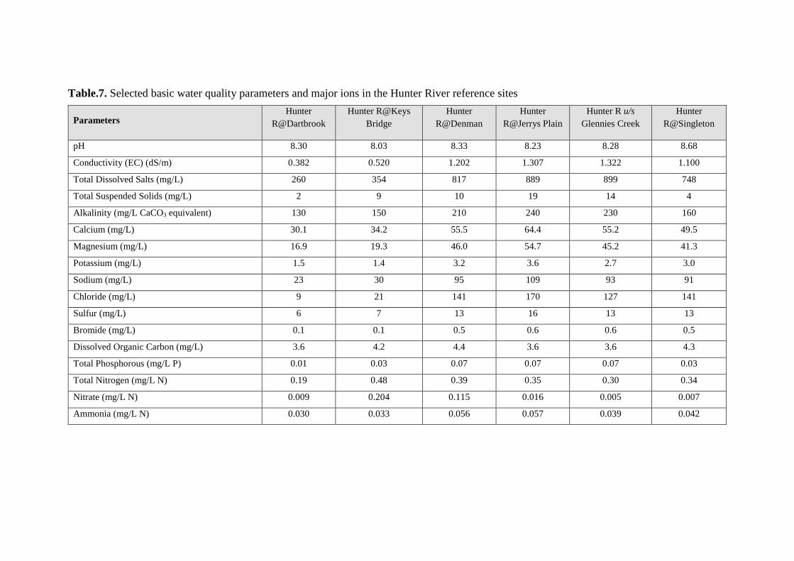
Table.7. Selected basic water quality parameters and major ions in the Hunter River reference sites
Parameters Hunter
R@Dartbrook Hunter R@Keys
Bridge Hunter
R@Denman Hunter
R@Jerrys Plain Hunter R u/s
Glennies Creek Hunter
R@Singleton
pH 8.30 8.03 8.33 8.23 8.28 8.68
Conductivity (EC) (dS/m) 0.382 0.520 1.202 1.307 1.322 1.100
Total Dissolved Salts (mg/L) 260 354 817 889 899 748
Total Suspended Solids (mg/L) 2 9 10 19 14 4
Alkalinity (mg/L CaCO3 equivalent) 130 150 210 240 230 160
Calcium (mg/L) 30.1 34.2 55.5 64.4 55.2 49.5
Magnesium (mg/L) 16.9 19.3 46.0 54.7 45.2 41.3
Potassium (mg/L) 1.5 1.4 3.2 3.6 2.7 3.0
Sodium (mg/L) 23 30 95 109 93 91
Chloride (mg/L) 9 21 141 170 127 141
Sulfur (mg/L) 6 7 13 16 13 13
Bromide (mg/L) 0.1 0.1 0.5 0.6 0.6 0.5
Dissolved Organic Carbon (mg/L) 3.6 4.2 4.4 3.6 3.6 4.3
Total Phosphorous (mg/L P) 0.01 0.03 0.07 0.07 0.07 0.03
Total Nitrogen (mg/L N) 0.19 0.48 0.39 0.35 0.30 0.34
Nitrate (mg/L N) 0.009 0.204 0.115 0.016 0.005 0.007
Ammonia (mg/L N) 0.030 0.033 0.056 0.057 0.039 0.042

5.1. METALS AND METALLOIDS IN THE WATER SAMPLES
The metals and metalloids in water samples are presented in Table 8. Most metals are
well below ANZECC guideline trigger values. Water hardness is an important
‘modifying factor’ in the ANZECC guideline when setting the appropriate trigger
values for metal contaminants. The applied trigger values for nickel and zinc adjusted
for water hardness as per ANZEC guidelines applies a multiplier of 9.0. After
adjustments, the total Zn concentrations exceeded trigger values in Dam 1N, Dam 9S
and CHPP (surge) (Fig.6). Nickel in the Hunter River reference sites was also highly
variable.
Total arsenic concentrations in the discharge dams was well below the irrigation
water guideline trigger values. However, speciation analysis found that arsenate (As V)
was approximately double the trigger level in the Mount Thorley Warkworth samples
(Dam 1 N and Dam 9S) (Fig. 7 & 8). The presence of low concentrations of arsenic in
ground water is not uncommon. Small amounts of arsenic have been reported in rocks,
soils and sediments and arsenic can be detected at low concentrations in most natural
waters – rainwater, rivers, lakes, groundwater and seawater [14]. Occasionally arsenic
is present in much higher concentrations, which can be concerning when the water is
used for drinking and the irrigation of crops.
The Mount Thorley Warkworth mines are located in the Permian coal seams
(Permian Tomago) (Fig.4). The predominant As-hosting minerals in this geology are
iron oxyhydroxides and As-bearing sulfides. In general, the lowering of groundwater,
or excavation, is known to result in the oxidation of As-bearing minerals and the
formation of iron oxides.

Figure.4. Hunter River Catchment geological classifications (Kellet et al. 1989)
Periodic fluctuations in groundwater, and /or progressive weathering of minerals and
soil, can lead to the mobilization of arsenic to groundwater and surface water.
The environmental and health consequences of arsenic have been the focus of
many studies [11]. A compounding factor is the effect of saline water, with its high
ionic concentrations, such as Na+, K+, Mg2+, HCO3- , Cl−, and SO4
2. The influence of
saline conditions, such as those found in the Hunter Valley, on the fate and effects of
arsenic have not been fully resolved.
Table.8. The dissolved metals and metalloids in the water samples (mg/L)
Sites/Parameters Al Asa As III As V Cu Nib Pbb Se Znb
Trigger Values 0.055 0.05 0.024 0.013 0.0014 0.099 0.091 0.011 0.072
Discharge water storage dams
Bengalla 0.012 0.016 0.0002 0.0020 0.003 0.001 0.001 0.009 0.005
Lake Liddell 0.003 0.005 0.0004 0.0010 0.004 0.004 0.001 0.003 0.003
Liddell R 0.010 0.007 0.0002 0.0050 0.001 0.002 0.001 0.014 0.006
RVS 0.010 0.001 0.0002 0.0013 0.007 0.008 0.001 0.013 0.013
Parnel's Dam 0.013 0.002 0.0002 0.0010 0.001 0.006 0.001 0.005 0.005
Dam 11 0.013 0.005 0.0004 0.0010 0.001 0.009 0.001 0.008 0.018
Lake James 0.020 0.010 0.0002 0.0066 0.001 0.008 0.001 0.004 0.008
Dam 1N MTW 0.008 0.025 0.0002 0.0224 0.004 0.002 0.001 0.003 0.116
Dam 9S MTW 0.007 0.029 0.0002 0.0276 0.003 0.005 0.001 0.007 0.040
CHPP (Surge) 0.054 0.008 0.0002 0.0074 0.014 0.020 0.001 0.012 0.074
ND 2 0.019 0.001 0.0002 0.0004 0.002 0.003 0.001 0.002 0.004
Hunter River reference sites
Hunter R@ Dartbrook
0.008 0.001 0.0002 0.0002 0.001 0.001 0.001 0.001 0.003
Hunter R@ Keys Bridge
0.003 0.001 <0.0002 0.0002 0.001 0.001 0.001 0.001 0.003
Hunter R@ Denman
0.003 0.001 0.0002 0.0002 0.001 0.001 0.001 0.001 0.019
Hunter R@ Jerrys Plain
0.004 0.001 0.0002 0.0002 0.001 0.001 0.001 0.001 0.018
Hunter R u/s Glennies Creek
0.023 0.001 0.0002 0.0002 0.001 0.001 0.001 0.001 0.320
Hunter R@ Singleton
0.005 0.001 0.0002 0.0002 0.002 0.001 0.001 0.001 0.003
Note: aThere are no trigger values for total arsenic, therefore the irrigation water guidance value is considered for comparison (0.05mg/L); bHardness adjusted trigger values as per ANZEC guidelines Table 3.4.3 (Ni and Zn conc x 9; Pb conc x 26.7).

Figure.5. Total concentrations nickel, copper and selenium in water samples (mg/L)
Figure.6. Total zinc in water samples (mg/L)
0.000
0.010
0.020
0.030
0.040
0.050
0.060
0.070
0.080
0.090
0.100
Conc
entr
atio
n (m
g/L)
Nickel Copper Selenium
0.0000
0.0500
0.1000
0.1500
0.2000
0.2500
0.3000
0.3500
Conc
entr
atio
n (m
g/L)
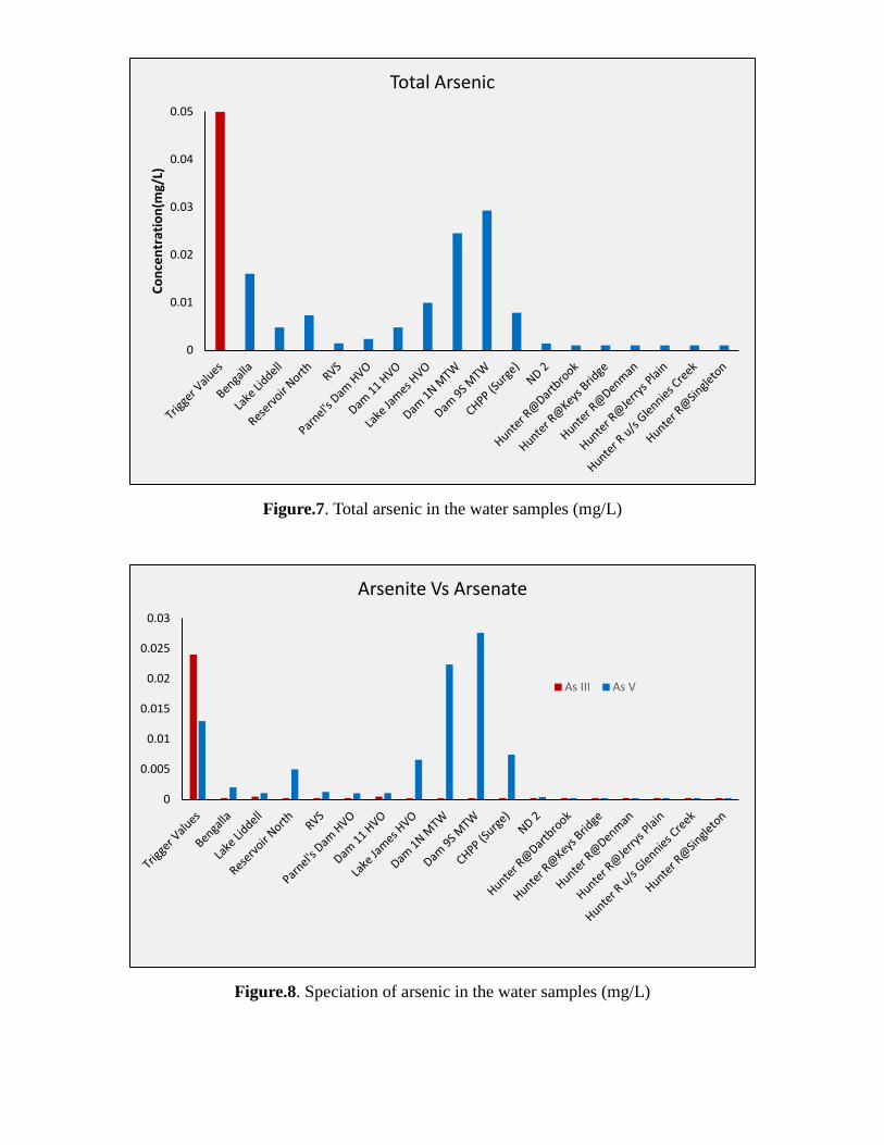
Figure.7. Total arsenic in the water samples (mg/L)
Figure.8. Speciation of arsenic in the water samples (mg/L)
0
0.01
0.02
0.03
0.04
0.05
Conc
entr
atio
n(m
g/L)
Total Arsenic
0
0.005
0.01
0.015
0.02
0.025
0.03
Arsenite Vs Arsenate
As III As V
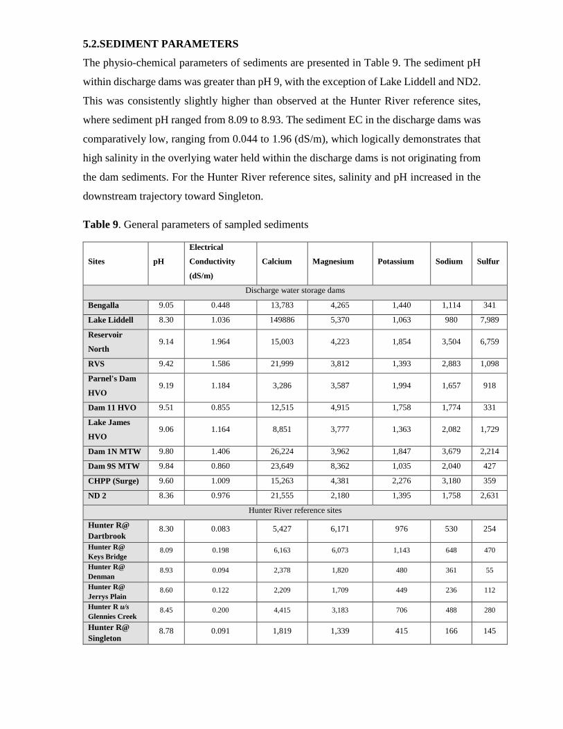
5.2.SEDIMENT PARAMETERS
The physio-chemical parameters of sediments are presented in Table 9. The sediment pH
within discharge dams was greater than pH 9, with the exception of Lake Liddell and ND2.
This was consistently slightly higher than observed at the Hunter River reference sites,
where sediment pH ranged from 8.09 to 8.93. The sediment EC in the discharge dams was
comparatively low, ranging from 0.044 to 1.96 (dS/m), which logically demonstrates that
high salinity in the overlying water held within the discharge dams is not originating from
the dam sediments. For the Hunter River reference sites, salinity and pH increased in the
downstream trajectory toward Singleton.
Table 9. General parameters of sampled sediments
Sites pH
Electrical
Conductivity
(dS/m)
Calcium Magnesium Potassium Sodium Sulfur
Discharge water storage dams
Bengalla 9.05 0.448 13,783 4,265 1,440 1,114 341
Lake Liddell 8.30 1.036 149886 5,370 1,063 980 7,989
Reservoir
North 9.14 1.964 15,003 4,223 1,854 3,504 6,759
RVS 9.42 1.586 21,999 3,812 1,393 2,883 1,098
Parnel's Dam
HVO 9.19 1.184 3,286 3,587 1,994 1,657 918
Dam 11 HVO 9.51 0.855 12,515 4,915 1,758 1,774 331
Lake James
HVO 9.06 1.164 8,851 3,777 1,363 2,082 1,729
Dam 1N MTW 9.80 1.406 26,224 3,962 1,847 3,679 2,214
Dam 9S MTW 9.84 0.860 23,649 8,362 1,035 2,040 427
CHPP (Surge) 9.60 1.009 15,263 4,381 2,276 3,180 359
ND 2 8.36 0.976 21,555 2,180 1,395 1,758 2,631
Hunter River reference sites
Hunter R@ Dartbrook
8.30 0.083 5,427 6,171 976 530 254
Hunter R@ Keys Bridge
8.09 0.198 6,163 6,073 1,143 648 470
Hunter R@ Denman
8.93 0.094 2,378 1,820 480 361 55
Hunter R@ Jerrys Plain
8.60 0.122 2,209 1,709 449 236 112
Hunter R u/s Glennies Creek
8.45 0.200 4,415 3,183 706 488 280
Hunter R@ Singleton
8.78 0.091 1,819 1,339 415 166 145

5.3.HEAVY METALS AND METALLOIDS IN SEDIMENT SAMPLES.
The heavy metal concentration of the sediment samples is given in Table 10. Except for
total arsenic (As), zinc (Zn), nickel (Ni), lead (Pb), chromium (Cr) and copper (Cu), all
other metals were below the analytical detection limit. The concentrations of As, Zn, Pb,
Cr and Cu were below the ‘Interim Sediment Quality Guidelines (ISQG) - low trigger
values’. Total Ni concentrations were within the trigger value range for most sites, with
low value exceedances at the Bengalla discharge dam, Dam1N and CHPP (surge) samples,
and the Hunter River reference samples collected from Dartbrook and Keys Bridge. Local
conditions vary naturally between waterways and it is necessary to calibrate trigger values
to local conditions and/or, develop 'local guideline levels', for these criteria to act as useful
benchmarks for water quality (DEC,2006). In this study, the elevated Ni concentrations
within the Hunter River reference sites highlight the relatively high regional baseline for
this element.

Table 10. Total concentrations of heavy metals and metalloids in sediment samples (mg/kg)
Metals
Arsenic Zinc Nickel Lead Chromium Copper
ISQG Low
(Trigger Value) 20 200 21 50 80 65
ISQG-High 70 410 52 220 370 270
Discharge water storage dams
Bengalla 12 54 31 13 27 17.9
Lake Liddell 12 53 17 7.7 12 52.2
Reservoir North 8.2 75 15 13 10 24.2
RVS 10 66 20 11 8.5 20.6
Parnel's Dam HVO 6.1 78 15 14 5.2 28.2
Dam 11 HVO 10 31 29 19 27 10.7
Lake James HVO 7.5 50 17 11 14 13.5
Dam 1N MTW 6.8 71 23 15 5.7 22.1
Dam 9S MTW 6.3 63 12 11 6.2 17.9
CHPP (Surge) 10 66 25 17 18 19.3
ND 2 6.3 55 20 12 7.5 9.8
Hunter River reference sites
Hunter R@ Dartbrook
3.5 56 28 4.2 20 17.2
Hunter R@ Keys Bridge
3.5 68 31 6.9 24 20.5
Hunter R@ Denman
2 19 16 2.3 12 6.7
Hunter R@ Jerrys Plain
2 16 12 2.2 11 5.8
Hunter R u/s Glennies Creek
2.0 27 23 3.0 17 10.8
Hunter R@ Singleton
2 61 8.3 5.9 7.2 5.0

Figure.9. Total copper (Cu) in the sediments samples (mg/kg)
Figure.10. Total lead (Pb) in the sediment samples (mg/kg)
0
10
20
30
40
50
60
70
Conc
ntra
tion
(mg/
kg)
0
5
10
15
20
25
30
35
40
45
50
Conc
entr
atio
n (m
g/kg
)

Figure.11. Total zinc (Zn) in the sediment samples (mg/kg)
Figure. 12. Total nickel (Ni) in the sediment samples (mg/kg)
0
20
40
60
80
100
120
140
160
180
200
Conc
entr
atio
n (m
g/kg
)
0
5
10
15
20
25
30
35
40
45
50
Conc
entr
atio
n (m
g/kg
)

Figure 13. Total arsenic (As) in the sediment samples (mg/kg)
Figure14. Total chromium (Cr) in the sediment samples (mg/kg)
0
2
4
6
8
10
12
14
16
18
20
Conc
entr
atio
n (m
g/kg
)
0
10
20
30
40
50
60
70
80
Conc
entr
atio
n (m
g/kg
)

5.4. THE SALINITY DILUTION FACTOR AND ITS IMPLICATIONS FOR METAL(LOID)S
The HRSTS was implemented to manage the discharge of saline water from mine sites and
power generators to the Hunter River (Dec 2006). The central aim of this scheme is to cap (i.e
limit), the maximum salinity, measured by electrical conductivity (EC), to an acceptable level.
The mechanism is though controlled discharge that balances high flow conditions in the Hunter
River with saline water discharge from mining and power generation operators. Through
careful control (seen in Fig. 15), the mixture of river and discharge water can be kept fresh to
meet water quality standards for other water users and the environment.
Figure 15. Hunter River flow categories (DEC, 2006)

For instance, the middle sector mine water discharge dam, Dam 9 at MTW operations last
discharged ~10.45 ML. Considering the HRSTS rules, the Hunter River flow must be
around 1800-6000 ML/day to be able to discharge. The 10.45 ML water discharged from
Dam 9, may therefore be diluted up to 172 times, even at 1800ML - the lower end of river
flow rate. Therefore the 0.027 mg/L of As (V) detected in Dam 9 would have been diluted
to below detection limit and trigger value (0.15 µg/L). According to the UHMD water
accounting framework (2016), during 2016, only 4 % of mine-water was discharged to
Hunter River. The total flow of water in Hunter River was around 238 GL in 2016, in which
2.7 GL was discharged from the mines. There is a possibility of 100 times dilution effect
of contaminants under normal discharge level. Furthermore, at times of release, pulse high
flow events, the dilution effect could be even greater. Therefore, risk to downstream water
users and the environment may be insignificant, as the concentration of As and other
contaminants will be below threshold trigger values in the receiving environment when
waters are permitted to be released under the HRSTS operations.
It is important to note that when the HRSTS scheme was initiated in 1995, salinity
management was the only key water quality issue being considered. The principles of
dilution as applied in the HRSTS to address the cumulative impact of salt discharge has
not been fully considered with regards to applicability of this scheme for ecotoxicology
and accumulative impact of other pollutants.

6. CONCLUSIONS AND RECOMMENDATION
• The pH of the discharge dam waters were alkaline and mostly above pH 9.
• The total nitrogen and nitrate-nitrogen were elevated in most of the discharge dams
associated with the coal mines.
• The overall metal(loid) concentrations in discharge dams were low.
• Sampling was undertaken during a very dry period and therefore, is representative of a
low-flow scenario where evaporation may enhance the concentration of soluble
elements in the discharge dams.
• Few metal(loid)s exceed the ANZECC guideline trigger values for both discharge dams
and Hunter River relevant reference sites. Therefore:
- Total arsenic in water samples are below the trigger value, speciation data showed
low level exceedance of Arsenate in MTW discharge dams.
- Zn concentration was higher in MTW and CHPP (surge) samples. The highest Zn
concentrations occurred in the Hunter River reference sites.
- Metal(loid) concentrations in the sediment were below trigger values, except for
Nickel. Nickel was higher in some discharge dams and the Hunter reference sites,
indicative of naturally elevated concentrations in the Hunter Region.
• Under the operational protocols of the HRSTS, discharge waters will be diluted by at
least a 10 - 100 x before entering the Hunter River. Therefore, any concentration of
metals and nutrients will fall below trigger values based on the data in this study. The
scope to consider implications to bioaccumulation, sub-threshold impacts, impacts of
salts on contaminant uptake and nitrogen are not clear.
• The extremely dry seasonal conditions that have taken the Hunter Valley into drought
at the time of sampling in mid-2017 and persistent evaporative loss of water from the
discharge dams), are likely to have had a concentrating effect on soluble As(V), Zn, Ni

and N. However, the potential effects (for increased and decreased) mobilisation and
transport of salts and metals, through increased run-off and ground water (sub surface)
contribution under normal to wetter rainfall conditions is difficult to predict and beyond
the scope of this study to resolve.
• Based on the study findings and in accordance with the recommendations of the
ANZECC guidelines and NSW Government directions, there is a basis to consider site-
specific risk assessments for those locations where elevated concentrations of
metal(loid)s and nutrients were identified. This may require further analyses to resolve
the spatial and temporal variation, source apportionment and ecotoxicological
implications of specific metals and nutrients. In addition, the comparative assessment
of nitrogen in a broader range of water storages and isotopic analyses to fingerprint
nitrogen sources may assist with the basic understanding and management of this aspect.
• When considering the overall water budget in the Upper Hunter, the elevated
metal(loid)s and nitrogen reported in this study will exert a minimal effect on the
downstream concentrations of these constituents under the HRSTS operations. Further
data on the seasonal variability and identification of the source of metals and nitrogen
within the mine sites and coal operations may prove useful for developing management
options that seek to intervene and prevent their accumulation within the HRSTS
discharge dams.

REFERENCES
1. Attalla, M., Day, S.J., Lange, T., Lilley, W., Morgan, S., 2007. NOx Emissions from Blasting in Open Cut Coal Mining in the Hunter Valley. CSIRO Energy Technology.
2. Australian and New Zealand guidelines for fresh and marine water quality in 2000. (www.deh.gov.au/water/quality/nwqms)
3. Climate and Health Alliance. Coal and health in the Hunter: Lessons from one valley for the world. http://d3n8a8pro7vhmx.cloudfront.net/caha/legacy_url/61/CAHA.CoalHunterValley.Report.FINAL_.Approvedforprint.pdf?1439938124
4. DEC (Department of Environment and Conservation). Hunter River Salinity Trading Scheme Working together to protect river quality and sustain economic development. NSW DEC publication, 2006; www.epa.nsw.gov.au/resources/licensing/hrsts/hrsts.pdf
5. Department of Environment and Resource Management (DERM). A study of the cumulative impacts on water quality of mining activities in the Fitzroy River Basin. QLD DERM Publication, 2008.
6. Ismail A, Toriman ME, Juahir H, Zain SM, Habir NL, Retnam A, Kamaruddin MK, Umar R, Azid A. Spatial assessment and source identification of heavy metals pollution in surface water using several chemometric techniques. Marine pollution bulletin. 2016 May 15;106(1):292-300.
7. Jiang M, Zeng G, Zhang C, Ma X, Chen M, Zhang J, Lu L, Yu Q, Hu L, Liu L. Assessment of heavy metal contamination in the surrounding soils and surface sediments in Xiawangang River, Qingshuitang District. PloS one. 2013 Aug 8;8(8):e71176.
8. Kellett, J. R. & Williams, Baden G. & Ward, J. K. & Australia. Bureau of Mineral Resources, Geology and Geophysics. (1989). Hydrogeochemistry of the upper Hunter River Valley, New South Wales.
9. Mandal, B.K., Suzuki, K.T., 2002. Arsenic round the world: a review, Talanta, 58: 201-235
10. Oluwoye, I., Dlugogorski, B.Z., Gore, J., Oskierski, H.C., Altarawneh, M. Atmospheric emission of x , Atmospheric Environment (2017), doi: 10.1016/j.atmosenv.2017.08.006.
11. Smedley, P.L., Kinniburgh, D.G., 2005. Sources and behavior of arsenic in natural water,
Chapter 1 in United Nations Synthesis Report on Arsenic in Drinking Water.