Embed Size (px)
Citation preview
Journal of Volcanology and Geothermal Research xxx (2009) xxx–xxx
VOLGEO-04382; No of Pages 16
Contents lists available at ScienceDirect
Journal of Volcanology and Geothermal Research
j ourna l homepage: www.e lsev ie r.com/ locate / jvo lgeores
ARTICLE IN PRESS
Evolution and hazards of a long-quiescent compound shield-like volcano: Cofre dePerote, Eastern Trans-Mexican Volcanic Belt
Gerardo Carrasco-Núñez a,⁎, Lee Siebert b, Rodolfo Díaz-Castellón a, Lorenzo Vázquez-Selem c, Lucia Capra a
a Centro de Geociencias, Universidad Nacional Autónoma de México, Campus UNAM Juriquilla, Boulevard Juriquilla 3001, Querétaro, Qro. 76230, Mexicob Smithsonian Institution, Global Volcanism Program, National Museum of Natural History, Washington, D.C. 20013-7012, USAc Instituto de Geografía, Universidad Nacional Autónoma de México, Cd. Universitaria 04510 México, D.F., Mexico
⁎ Corresponding author.E-mail address: [email protected] (G.
0377-0273/$ – see front matter © 2009 Elsevier B.V. Aldoi:10.1016/j.jvolgeores.2009.08.010
Please cite this article as: Carrasco-NúñezPerote, Eastern Trans-Mexican Volcanic Be
a b s t r a c t
a r t i c l e i n f oArticle history:Received 24 October 2008Accepted 10 August 2009Available online xxxx
Keywords:compound volcanoesshield volcanoesvolcanic evolutionvolcanic hazardsinstabilityCofre de PeroteMexico
Cofre de Perote (Nauhcampatépetl) volcano lies at the northern end of the Citlaltépetl–Cofre de Perotevolcanic range (CCVR) that is the easternmost of several volcanic chains orthogonal to the E–W trend of theTrans-Mexican Volcanic Belt (TMVB). The CCVR is an important physiographic feature separating the Gulfcoastal plains from the Altiplano, with pronounced differential relief of more than 1000 m and slopingsubstrate promoting major edifice failures toward the Gulf of Mexico coastal plain of most of the volcanoesthat form that chain. Its structure, composition, and volcanic history diverge significantly from that of thelarge dominantly andesitic stratovolcanoes that have been the major focus of research efforts in the TMVB.Cofre de Perote volcano is dominated by the successive emplacement of basaltic andesite, andesitic–trachyandesitic to dacitic lava flows and associated breccias erupted through different vents that built amassive low-angle compound shield-like volcano, in contrast to a typical steep stratocone. Despite thatapparently stable morphology, repeated edifice collapse has left massive horseshoe-shaped scarps thattruncate the eastern side of the edifice. Five major evolutionary stages characterize the growth of thisvolcano including: 1) emplacement of a multiple-vent dome complex forming the basal structure of Cofre dePerote around 1.3–0.51 Ma; 2) construction of the basal part of the compound shield volcano from at leasttwo main upper-edifice vents and minor flank vents at about 0.42–0.31 Ma; 3) effusion of the summit lavasthrough multiple vents at 0.25–0.2 Ma; 4) late-stage, large-volume edifice collapse on at least two occasions(ca. 40 ka and ca. 11–13 ka), producing long-runout debris avalanches and debris flows that traveled to theeast; and 5) nearly simultaneous eruption of both alkaline and calc-alkaline Pleistocene-to-Holocenemonogenetic cones (likely related to regional volcanism) through the flanks of the Cofre de Perote edifice.Long-term factors influencing edifice failure include hydrothermal alteration, increased pore pressure fromglacially derived water, extension produced by repetitive volcanism along the chain parallel to the maximumhorizontal compression, and perhaps most significantly, construction of the edifice over a sharply eastward-sloping substrate. Evolution of a compound shield volcano like Cofre de Perote reveals that even relativelystable, long-quiescent edifices with a gentle morphology that are considered apparently extinct structurespose a significant hazard to the nearby populated areas, as post-eruptive sector collapses have occurred inrecent times (40–11 ka) not associated with contemporaneous volcanic activity.
© 2009 Elsevier B.V. All rights reserved.
1. Introduction
Cofre de Perote is the northernmost large volcano (4282 masl) ofthe Citlaltépetl–Cofre de Perote volcanic range (CCVR) (Fig. 1). Ittowers above Xalapa, the capital city of the State of Veracruz, has adiameter of about 25–30 km, and rises more than 3000 m above thecoastal plain to the east. That volcanic range lies near the eastern limitof the Trans-Mexican Volcanic Belt (TMVB), a Neogene–Quaternaryprovince dominated by a wide variety of volcanic structures ranging
Carrasco-Núñez).
l rights reserved.
, G., et al., Evolution and halt, J. Volcanol. Geotherm. Res
from broad monogenetic fields, large stratovolcanoes, and lava domesand calderas, to isolated cinder cones andmaars. A half dozen of thesevolcanoes have erupted since the onset of the Spanish era in about1500 AD.
The summit of Cofre de Perote has a box shaped lava flow remnant(Fig. 2B), which is a distinctive feature of the mountain and led toits being referred to as the “Treasure chest of Perote” (Cofre de Perote)or in Nahuatl language: Nauhcampatépetl, which means four-sidedmountain. Cofre de Perote (or Cofre, for brevity) as most of the largevolcanoes that characterize the TMVB, is commonly regarded as astratovolcano; however, detailed field studies have shown that thisvolcanohas amorphology, structure, composition and eruptivehistorythat differ from that shown by a typical composite or stratovolcano.
zards of a long-quiescent compound shield-like volcano: Cofre de. (2009), doi:10.1016/j.jvolgeores.2009.08.010
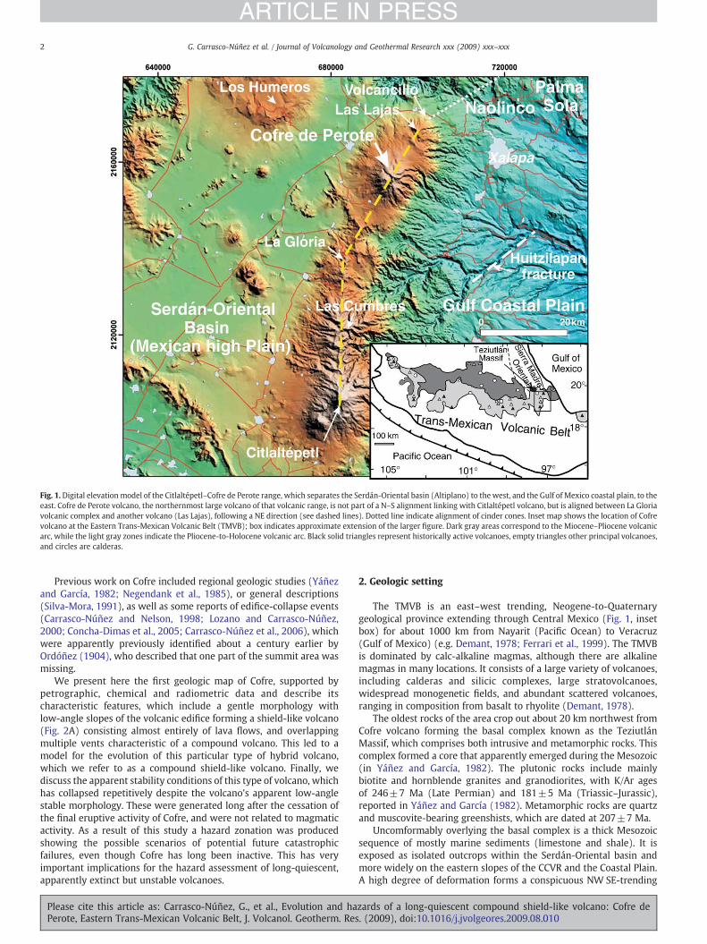
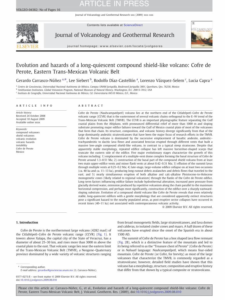
Fig. 1.Digital elevation model of the Citlaltépetl–Cofre de Perote range, which separates the Serdán-Oriental basin (Altiplano) to the west, and the Gulf of Mexico coastal plain, to theeast. Cofre de Perote volcano, the northernmost large volcano of that volcanic range, is not part of a N–S alignment linking with Citlaltépetl volcano, but is aligned between La Gloriavolcanic complex and another volcano (Las Lajas), following a NE direction (see dashed lines). Dotted line indicate alignment of cinder cones. Inset map shows the location of Cofrevolcano at the Eastern Trans-Mexican Volcanic Belt (TMVB); box indicates approximate extension of the larger figure. Dark gray areas correspond to the Miocene–Pliocene volcanicarc, while the light gray zones indicate the Pliocene-to-Holocene volcanic arc. Black solid triangles represent historically active volcanoes, empty triangles other principal volcanoes,and circles are calderas.
2 G. Carrasco-Núñez et al. / Journal of Volcanology and Geothermal Research xxx (2009) xxx–xxx
ARTICLE IN PRESS
Previous work on Cofre included regional geologic studies (Yáñezand García, 1982; Negendank et al., 1985), or general descriptions(Silva-Mora, 1991), as well as some reports of edifice-collapse events(Carrasco-Núñez and Nelson, 1998; Lozano and Carrasco-Núñez,2000; Concha-Dimas et al., 2005; Carrasco-Núñez et al., 2006), whichwere apparently previously identified about a century earlier byOrdóñez (1904), who described that one part of the summit area wasmissing.
We present here the first geologic map of Cofre, supported bypetrographic, chemical and radiometric data and describe itscharacteristic features, which include a gentle morphology withlow-angle slopes of the volcanic edifice forming a shield-like volcano(Fig. 2A) consisting almost entirely of lava flows, and overlappingmultiple vents characteristic of a compound volcano. This led to amodel for the evolution of this particular type of hybrid volcano,which we refer to as a compound shield-like volcano. Finally, wediscuss the apparent stability conditions of this type of volcano, whichhas collapsed repetitively despite the volcano's apparent low-anglestable morphology. These were generated long after the cessation ofthe final eruptive activity of Cofre, and were not related to magmaticactivity. As a result of this study a hazard zonation was producedshowing the possible scenarios of potential future catastrophicfailures, even though Cofre has long been inactive. This has veryimportant implications for the hazard assessment of long-quiescent,apparently extinct but unstable volcanoes.
Please cite this article as: Carrasco-Núñez, G., et al., Evolution and haPerote, Eastern Trans-Mexican Volcanic Belt, J. Volcanol. Geotherm. Res
2. Geologic setting
The TMVB is an east–west trending, Neogene-to-Quaternarygeological province extending through Central Mexico (Fig. 1, insetbox) for about 1000 km from Nayarit (Pacific Ocean) to Veracruz(Gulf of Mexico) (e.g. Demant, 1978; Ferrari et al., 1999). The TMVBis dominated by calc-alkaline magmas, although there are alkalinemagmas in many locations. It consists of a large variety of volcanoes,including calderas and silicic complexes, large stratovolcanoes,widespread monogenetic fields, and abundant scattered volcanoes,ranging in composition from basalt to rhyolite (Demant, 1978).
The oldest rocks of the area crop out about 20 km northwest fromCofre volcano forming the basal complex known as the TeziutlánMassif, which comprises both intrusive and metamorphic rocks. Thiscomplex formed a core that apparently emerged during the Mesozoic(in Yáñez and García, 1982). The plutonic rocks include mainlybiotite and hornblende granites and granodiorites, with K/Ar agesof 246±7 Ma (Late Permian) and 181±5 Ma (Triassic–Jurassic),reported in Yáñez and García (1982). Metamorphic rocks are quartzand muscovite-bearing greenshists, which are dated at 207±7 Ma.
Uncomformably overlying the basal complex is a thick Mesozoicsequence of mostly marine sediments (limestone and shale). It isexposed as isolated outcrops within the Serdán-Oriental basin andmore widely on the eastern slopes of the CCVR and the Coastal Plain.A high degree of deformation forms a conspicuous NW SE-trending
zards of a long-quiescent compound shield-like volcano: Cofre de. (2009), doi:10.1016/j.jvolgeores.2009.08.010
Fig. 2. Photos showing the morphology of Cofre. A) Characteristic profile of the Cofre volcanic edifice looking from the southwest, showing gentle slopes like those typical of shieldvolcanoes. In the forested middle ground, the basal dome complex units (stage I) are exposed; B) uppermost trachytic lava flows forming the characteristic four-sided “treasurechest,” looking from the northwest.
3G. Carrasco-Núñez et al. / Journal of Volcanology and Geothermal Research xxx (2009) xxx–xxx
ARTICLE IN PRESS
folded and faulted mountain range (in the Sierra Madre Orientalprovince) as a result of the Laramide Orogenie.
In the area of this study, the NW SE-trending sedimentary sequenceis partially covered by the mostly calc-alkaline E–W-trending volca-nism. In fact, it can be considered that the rocks of that sedimentaryprovince form the regional basement of the Eastern TMVB (Yáñez andGarcía, 1982).
The CCVR lies near the easternmost part of the TMVB and forms animportant physiographic barrier with more than 1000 m in reliefseparating the Serdán-Oriental basin in the Mexican High Plain(Altiplano), to the west, and the Gulf of Mexico coastal plain, to theeast (Fig. 1). Contrasting morphological conditions characterize eachof these provinces. The Serdán-Oriental basin has an erratic drainagenetwork, and its landscape is dominated by ephemeral streams andshallow lakes, whereas the Gulf Coastal Plain has a well-developed
Please cite this article as: Carrasco-Núñez, G., et al., Evolution and haPerote, Eastern Trans-Mexican Volcanic Belt, J. Volcanol. Geotherm. Res
and integrated drainage network with V-shaped valleys and perma-nent streams.
The Serdán-Oriental is a closed basin comprising a relatively flatarea dotted by isolated volcanoes (Fig. 1). It is characterized by abimodal monogenetic volcanism that includes small, isolated scoriaand lava cones of basaltic composition and some maar volcanoes withboth basaltic and rhyolitic composition, as well as a few relativelylarge rhyolitic lava domes and a caldera complex (Los Humeros)closing the northern drainage of the Serdán-Oriental basin (Ferriz andMahood, 1984).
In contrast, theCCVR is a 70-km longchain that includes several largestratovolcanoes and volcanic complexes, minor cinder cones, and a fewsilicic lava domes. It comprises two main alignments of volcanoesincluding a N–S trend formed by La Gloria (Cerro Desconocido)–LasCumbres–Citlaltépetl volcanoes (Fig. 1) and a second, NE–SW-trending
zards of a long-quiescent compound shield-like volcano: Cofre de. (2009), doi:10.1016/j.jvolgeores.2009.08.010
4 G. Carrasco-Núñez et al. / Journal of Volcanology and Geothermal Research xxx (2009) xxx–xxx
ARTICLE IN PRESS
alignment of volcanoes that contains the northernmost Las Lajas–Cofrede Perote–La Gloria (Cerro Desconocido) volcanoes. Regional workby Negendank et al. (1985) showed the structure and geology ofthis volcanic range, whereas more detailed studies show the general
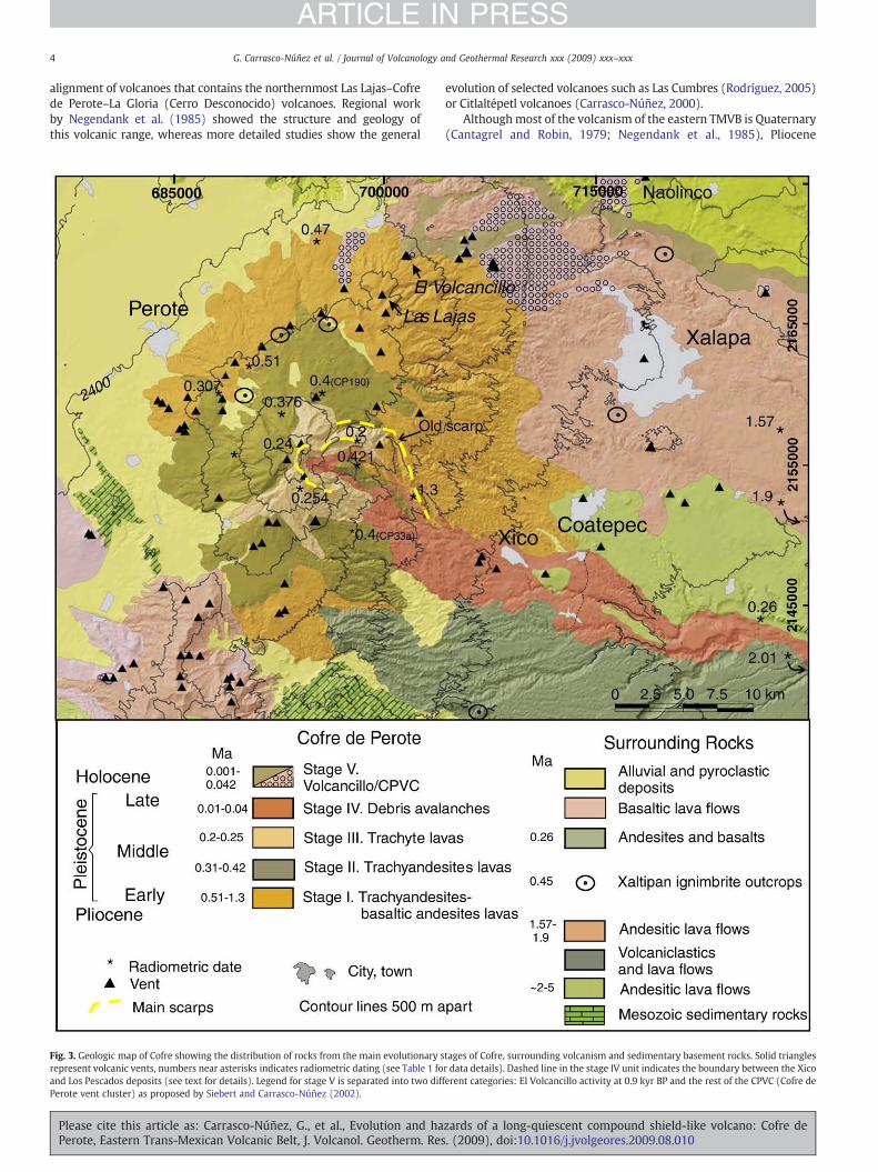
Fig. 3. Geologic map of Cofre showing the distribution of rocks from the main evolutionary srepresent volcanic vents, numbers near asterisks indicates radiometric dating (see Table 1 foand Los Pescados deposits (see text for details). Legend for stage V is separated into two difPerote vent cluster) as proposed by Siebert and Carrasco-Núñez (2002).
Please cite this article as: Carrasco-Núñez, G., et al., Evolution and haPerote, Eastern Trans-Mexican Volcanic Belt, J. Volcanol. Geotherm. Res
evolution of selected volcanoes such as Las Cumbres (Rodríguez, 2005)or Citlaltépetl volcanoes (Carrasco-Núñez, 2000).
Althoughmost of the volcanism of the eastern TMVB is Quaternary(Cantagrel and Robin, 1979; Negendank et al., 1985), Pliocene
tages of Cofre, surrounding volcanism and sedimentary basement rocks. Solid trianglesr data details). Dashed line in the stage IV unit indicates the boundary between the Xicoferent categories: El Volcancillo activity at 0.9 kyr BP and the rest of the CPVC (Cofre de
zards of a long-quiescent compound shield-like volcano: Cofre de. (2009), doi:10.1016/j.jvolgeores.2009.08.010
Table 1Radiometric dates of the Cofre de Perote rocks and surroundings.
Sample Lab.#
CoordinatesUTM (GSR80)
Method Material analyzed Rock type Rock unit Age (Ma) ±2 sigma Ref.
CP-32 97-4468 698504-2159061 K/Ar w. r. trachyte Stage III 0.20±0.10 1CP-44a 97-4670 694331-2156617 K/Ar w. r. trachyte Stage III 0.24±0.05 1CP-24c 57388 694384-2154403 40Ar/39Ar gr. con. trachyand. Stage III 0.254±0.01 1CP-109 51851 726279-2144164 40Ar/39Ar gr. con. bas. and. Outer volcan. 0.26±0.03 1CP-011 57387 688577-2160215 40Ar/39Ar gr. con. trachyand. Stage II 0.307±0.035 1CP-190 57385 692869-2159707 40Ar/39Ar gr. con. trachyand. Stage II 0.376±0.017 1CP-33a 51854 697573-2150840 40Ar/39Ar plag. trachyand. Stage II 0.40±0.03 1CP-190a 01-5814 695265-2160895 K/Ar w. r. trachyand. Stage II 0.40±0.10 1CP-0642 57382 698808-2155313 40Ar/39Ar gr. con. trachyand. Stage II 0.421±0.011 1VE-21 K/Ar w. r. andesite Stage I 0.47±0.20 2CP-013 57382⁎ 690715-2162083 40Ar/39Ar gr. con. bas. and. Stage I 0.51±0.06 1CP-40 97-4669 702043-2152919 K/Ar w. r. b. trachyand. Stage I, base 1.30±0.12 1VE-52 K/Ar w. r. andesite Outer volcan. 1.57±0.05 2VE-66 K/Ar w. r. basalt Outer volcan. 1.90±0.06 2441 K/Ar w. r. andesite Outer volcan. 1.90±? 3CP-15a 97-4667 726735-2142662 K/Ar w. r. rhy. ign. Outer volcan. 2.01±0.10 1
40Ar/39Ar dating performed at New Mexico Geochronological Research Laboratory analyzed by furnace step-heat. K/Ar dating at Mass Spec Services, New Jersey, USA. All errorsquoted at 2 sigma, except for K/Ar dates (1 sigma). Material analyzed: w.r. — whole rock, gr. con. — groundmass concentrate, plag. — plagioclase. Rock type: trachyand. —trachyandesite, bas. and. — basaltic andesite, b. trachyand. — basaltic trachyandesite; rhy. ign. — rhyolitic ignimbrite. Rock unit: outer volcan. — outer volcanism.Reference: 1 — this study; 2 — Cantagrel and Robin (1979); 3 — Yáñez and García (1982).
5G. Carrasco-Núñez et al. / Journal of Volcanology and Geothermal Research xxx (2009) xxx–xxx
ARTICLE IN PRESS
volcanism ranging from about 2 to 5 Ma is present towards thenorthern end of this area (Yáñez and García, 1982). Also the westernboundary of the Serdán-Oriental area is composed of an importantepisode of volcanism of Miocene age (9–11 Ma) around Cerro Grandevolcano (Carrasco-Núñez et al., 1997). Although Cofre is long inactiveand Citlaltépetl (or Pico de Orizaba) volcano at the other end of therange is active, it is not possible to establish a relative southward-younging age of the volcanism. This is because there are numeroussmall cinder cones such as El Volcancillo, which was active as recentlyas the last thousand years (Siebert and Carrasco-Núñez, 2002). Also,late Pleistocene explosive events such as the Quetzalapa pumice,erupted at 20 kyr, are reported on the western flank of Las Cumbresvolcano (Rodríguez et al., 2002).
3. Stratigraphy and evolution of Cofre
The evolution of Cofre volcano can be separated into five differentstages. The first three correspond to main edifice-building stages (I, II,and III) followed by important repetitive post-eruptive collapse events(IV) and Holocene volcanism that occurred at the northern flank of theCofre volcanic edifice (V), extending to the NE in the Naolinco area(Fig. 3). A total of 12 new radiometric ages including both 40Ar/39Arand K/Ar dates (Table 1) provides precise ages to establish a detailedchronostratigraphy for the Cofre evolution. Details about themethods,errors, material analyzed, etc., are provided in Table 1.
Table 2Major elements of the Cofre de Perote rocks.
Sample CP40a CP013 CP018 CP014 CP011 CP36 CP42
Unit I I I I I I II
SiO2 53.94 56.31 57.76 60.24 60.86 62.13 56.98TiO2 1.47 1.25 1.01 1.05 1.01 0.86 0.96Al2O3 16.39 17.00 17.25 16.66 16.73 16.95 15.96Fe2O3t 8.65 7.15 6.28 6.17 5.58 5.49 7.28MnO 0.12 0.13 0.11 0.09 0.09 0.08 0.11MgO 4.53 4.51 3.31 2.53 2.93 2.12 5.25CaO 7.78 6.97 6.33 5.38 5.31 3.80 7.69Na2O 3.56 3.64 3.63 3.93 3.54 3.93 3.27K2O 2.14 1.99 3.15 2.66 3.09 3.54 1.63P2O5 0.45 0.29 0.23 0.26 0.22 0.25 0.21LOI 0.35 0.22 0.33 0.51 0.05 0.96 0.22Total 99.38 99.44 99.39 99.48 99.41 100.10 99.57
Analyses performed at the LUGIS Lab of the Instituto de Geología, UNAM (Mexico).
Please cite this article as: Carrasco-Núñez, G., et al., Evolution and haPerote, Eastern Trans-Mexican Volcanic Belt, J. Volcanol. Geotherm. Res
It is important to emphasize the almost entire dominance of effusiveproducts during the constructional stages of Cofre. However, in a distallocation to the SW, a few pyroclastic deposits were found, mainlyconsisting of pumice fallout layers. However, due to the scarcity ofexposures and apparent different composition of these pyroclasts inrelation to the overlying lavas, their provenance is uncertain.
Petrographic studies (more than 25 thin sections) and chemicalanalyses (15 samples, Table 2) indicate that the composition of thelavas from the different stages is quite similar, typically consisting ofporphyritic andesites–trachyandesites with large plagioclase pheno-crysts and minor pyroxenes (both ortho and clinopyroxene).
3.1. Stage I. ancient volcanic complex (1.3–0.51 Ma)
An extensive volcanic field developed, apparently over an irregularpaleotopography made by a Mesozoic sedimentary sequence, LatePliocene ignimbrite rocks (around 2Ma, Table 1), and Pliocene andesiticlava flows. The closest exposure of the sedimentary rocks is located only18 km SW from the Cofre summit while the ignimbrites are exposedabout 35 km to the ESE, and the Pliocene andesites (2–5 Ma, in Yáñezand García, 1982) crop out about 22 km to the north (Fig. 3).
This volcanic complex forms the basal structure on which theCofre edifice was built. It comprises a large number of individualvolcanoes, dominated by trachyandesitic and trachytic lava domes andtrachyandesitic and basaltic andesite lava flows with a widespread
CP31 CP43 CP24e CP33a CP41 CP24a CP017 CP44a
II II II II III III III III
60.16 61.56 61.69 61.97 62.60 63.65 64.70 65.450.98 0.94 0.92 0.97 0.95 0.83 0.81 0.75
16.44 16.56 16.56 16.31 15.43 16.03 15.95 15.206.19 5.44 5.50 5.47 5.51 5.14 4.56 4.570.09 0.08 0.08 0.07 0.08 0.08 0.08 0.073.30 2.82 2.92 3.00 2.80 2.39 1.86 2.035.41 4.05 4.61 4.61 4.14 4.10 3.75 3.453.83 3.88 3.85 3.85 3.88 4.01 4.04 3.822.74 3.17 3.29 3.28 3.68 3.27 3.22 3.580.23 0.23 0.20 0.21 0.21 0.20 0.20 0.180.42 0.96 0.47 0.36 0.11 0.13 0.13 0.31
99.79 99.69 100.08 100.10 99.38 99.83 99.29 99.41
zards of a long-quiescent compound shield-like volcano: Cofre de. (2009), doi:10.1016/j.jvolgeores.2009.08.010
6 G. Carrasco-Núñez et al. / Journal of Volcanology and Geothermal Research xxx (2009) xxx–xxx
ARTICLE IN PRESS
distribution all around the main edifice of the Cofre volcano. Atrachyandesite lava flow considered as representative of this ancienteruptive stage and located on the western flank of Cofre (see locationat Fig. 3) was dated at 0.51±0.06 Ma by the 40Ar/39Ar method(groundmass concentrated) (Table 1). This date is in accordancewith aK/Ar date reported by Cantagrel and Robin (1979) at 0.47±0.2 Ma forlavas located at the northern end of this volcanic unit (Fig. 3), althoughthe latter date has a high error. However, we also obtained a K–Ar date(groundmass concentrated) of 1.3±0.12 Ma (Table 1) for a basalticandesite lava that outcrops at the SE slopes near the summit area(see location at Fig. 3).
Even though the difference between those dates is around 0.8 Ma,all of the lava flows can be grouped into a single long eruptive periodthat formed the ancient volcanic complex. This stage was character-ized by the formation of numerous lava domes and some lava flows,all surrounding the Cofremain edifice, due to an intermittent injectionof magmas through different vents that never concentrated in a singlesite to form an individual volcanic edifice.
There are some other K–Ar dates for andesitic lavas reported atthe Eastern distal zones from Cofre that provided older ages of 1.57and 1.9 Ma (Cantagrel and Robin, 1979). However, the general spatialconfiguration and structural geometry of these lavas are clearly dif-ferent from those of stage I. These features and their location far fromthe Cofre main edifice, indicate that this volcanism represents olderrocks of the CCVR. There is also another older date reported at 1.9 Mafor a rock located near the town of Perote (Yáñez and García, 1982),but we did not include it as part of this eruptive stage because nofurther details are provided, and the location is uncertain.
Trachyandesites and trachytes always show a porphyritic texturewith plagioclase phenocrysts, while the basaltic andesite rocks areaphanitic. Under the microscope, two pyroxenes can be identifiedin the trachyandesites, and microphenocrysts of olivine with minorproportions of pyroxenes (augite) in the basaltic andesites; in bothcases the crystals are subrounded by a microlitic groundmass. A fewsamples contain scarce small biotite crystals, and some rocks show aseriate texture, and/or skeletal and glomeroporphyiritic textures.
A debris avalanche deposit was identified on the foot of an oldscarp structure affecting lavas of stage I, and apparently also lavas ofstage II (see location on Fig. 3, underlying lavas of stage II dated at0.421Ma). This deposit is unconformably covered by andesitic lavas ofstage II that may represent the uppermost effusive products of thatstage. Apparently the ancient volcanic complex formed during thestage I was affected by a sector collapse event, but because the depositis buried in most of its extension, only scarce, isolated exposures arepresent. Nevertheless, this indicates that edifice collapse also occurredbetween periods of early construction of the volcano.
3.1.1. Pyroclastics from nearby volcanoes (0.45 Ma)A catastrophic caldera-forming eruption associated with Los
Humeros volcanic center occurred around 0.46±0.02 Ma (Ferrizand Mahood, 1984)–0.45±0.09 Ma (Carrasco-Núñez et al., 1997)using K/Ar dating in both cases. Los Humeros caldera, located just25 km NW of Cofre (Fig. 1), produced a sudden and voluminousdischarge of 115 km3 of pyroclastic material with minor lithicfragments. This powerful eruption led to the formation of Los Humeroscaldera that produced very energetic pyroclastic flows designated asthe Xaltipan ignimbrite (Ferriz and Mahood, 1984), which traveledradially covering extensive areas.
Although most of the pyroclastic flows tended to move aroundtopographic highs, the Cofre basal complex was not high enough toinhibit the passing of the Xaltipan ignimbrite eastward, so it appearsas scattered exposures of the Xaltipan ignimbrite partially coveringthe andesites of the basal complex east of Cofre. In fact, patches ofpyroclastic deposits forming the Xaltipan ignimbrite overlie lava flowsof stage I at the northern slopes of the Cofre volcanic edifice, and arealso found E and SE of the volcano (see locations on Fig. 3).
Please cite this article as: Carrasco-Núñez, G., et al., Evolution and haPerote, Eastern Trans-Mexican Volcanic Belt, J. Volcanol. Geotherm. Res
3.2. Stage II. Cofre de Perote compound shield-like edifice construction(0.42–0.31 Ma)
During an eruptive period ranging from 0.42 to 0.31 Ma (Table 1)volcanic activity was concentrated along different vents with a moreclosely spaced distribution around the present summit area. This gaverise to the construction of a single compound volcano, although thelavas were emplaced through different vents. In fact, the emissionof magma through distinct conduits allowed the volcano to growlike shield volcanoes do through peripheral flank or rifting systemson smooth slopes, instead of forming a steep pile as with typical“stratovolcanoes.”
40Ar/39Ar dating reported in this paper confirms previous unpub-lished K/Ar dating for rocks representing this stage (Table 1).Correlation of rocks on the upper slopes fits well with obtained agesof 0.376±0.017 Ma (40Ar/39Ar date) to the west, 0.4±0.1 Ma (K/Ardate) to the north, 0.4±0.03 Ma (40Ar/39Ar date) to the south and,0.421±0.011 Ma (40Ar/39Ar date) to the east. In fact, the latter date(sample CP-0642) comes from the same location as sample CP-33adated at 0.4±0.03 (Table 1). A younger date of 0.307±0.035 Ma(40Ar/39Ar)was obtained for a trachyandesitic lava flowof thewesternlower flank (see location in Fig. 3), which partially covers stage I lavas.
Massive jointed trachyandesitic lava flows are dominant in thisstage; exhibiting a characteristic porphyritic texture and containingtwo pyroxenes within a microlitic (<0.05 mm) groundmass. Underthe microscope, some plagioclase crystals show skeletal and sievetextures, revealing disequilibrium conditions. Only in a few cases,small crystals of biotite are present. Some of the basaltic andesite lavasalso show an aphanitic texture and petrographically contain smallmicrophenocrysts of plagioclase, pyroxenes and Fe–Mg oxides.
3.3. Stage III. final multi-vent activity (0.25–0.2 Ma)
The activity of this stage is localized at the summit area and ischaracterized by the emission of highly jointed trachyte–dacite lavaflows and associated brecciated products. In some cases thesedeveloped a characteristic radial fracturing pattern during theiremplacement as injected lava domes that rose towards the uppersurface (Fig. 4A) and thenmoved downslope. Intense glacial erosionalprocesses molded the uppermost lavas of this final effusive activity,generating an isolated four-sided box at the summit area (Fig. 2B).
Stage III lavas are distributed in all directions around the volcanicedifice except towards the west (Fig. 3), due to the topographiccontrol exerted by the highest point of the stage II lavas, where oneof its most important vents was apparently located. However, themorphology of this younger edifice is truncated at its eastern side, sothe summit area displays a spectacular set of scarps that together forma horseshoe-shaped amphitheater (Fig. 4B and inset photo).
Lavas of this stage are porphyritic with large plagioclase pheno-crysts, and in thin section two pyroxenes, magnetite and hematite areobserved, similar to the general composition of the lavas from theother stages; however, they generally do not show disequilibriumtextures as do the lavas of the other stages. Lavas from the summit areawere dated at 0.2±0.1 and 0.24±0.05 Ma by the K/Ar method and0.254±0.010 Ma by the 40Ar/39Ar method (Table 1).
A glacial advance that reached ca. 3000 m on the slopes ofIztaccíhuatl (located 150 km to thewest) was identified (White, 1962,1986) and dated (Vázquez-Selem and Heine, 2004) at ca. 0.195 Ma.Although no deposits of this event have been recognized so far onCofre, the elevation of the mountain supports the possibility ofextensive glaciation shortly after stage III.
3.4. Stage IV. post-volcanism multiple collapses (44 to 11–13 kyr)
The compound, horseshoe-shaped amphitheater that charac-terizes the ESE part of the Cofre summit area is clear evidence of the
zards of a long-quiescent compound shield-like volcano: Cofre de. (2009), doi:10.1016/j.jvolgeores.2009.08.010
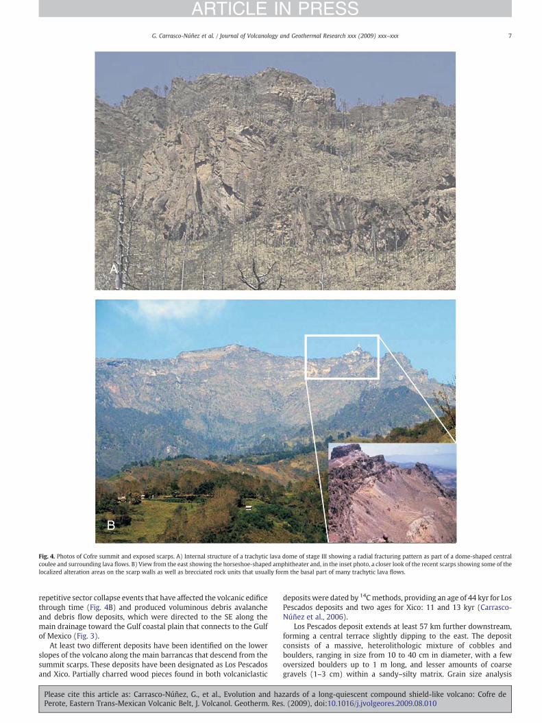
Fig. 4. Photos of Cofre summit and exposed scarps. A) Internal structure of a trachytic lava dome of stage III showing a radial fracturing pattern as part of a dome-shaped centralcoulee and surrounding lava flows. B) View from the east showing the horseshoe-shaped amphitheater and, in the inset photo, a closer look of the recent scarps showing some of thelocalized alteration areas on the scarp walls as well as brecciated rock units that usually form the basal part of many trachytic lava flows.
7G. Carrasco-Núñez et al. / Journal of Volcanology and Geothermal Research xxx (2009) xxx–xxx
ARTICLE IN PRESS
repetitive sector collapse events that have affected the volcanic edificethrough time (Fig. 4B) and produced voluminous debris avalancheand debris flow deposits, which were directed to the SE along themain drainage toward the Gulf coastal plain that connects to the Gulfof Mexico (Fig. 3).
At least two different deposits have been identified on the lowerslopes of the volcano along the main barrancas that descend from thesummit scarps. These deposits have been designated as Los Pescadosand Xico. Partially charred wood pieces found in both volcaniclastic
Please cite this article as: Carrasco-Núñez, G., et al., Evolution and haPerote, Eastern Trans-Mexican Volcanic Belt, J. Volcanol. Geotherm. Res
deposits were dated by 14Cmethods, providing an age of 44 kyr for LosPescados deposits and two ages for Xico: 11 and 13 kyr (Carrasco-Núñez et al., 2006).
Los Pescados deposit extends at least 57 km further downstream,forming a central terrace slightly dipping to the east. The depositconsists of a massive, heterolithologic mixture of cobbles andboulders, ranging in size from 10 to 40 cm in diameter, with a fewoversized boulders up to 1 m long, and lesser amounts of coarsegravels (1–3 cm) within a sandy–silty matrix. Grain size analysis
zards of a long-quiescent compound shield-like volcano: Cofre de. (2009), doi:10.1016/j.jvolgeores.2009.08.010
8 G. Carrasco-Núñez et al. / Journal of Volcanology and Geothermal Research xxx (2009) xxx–xxx
ARTICLE IN PRESS
indicates that the deposit has a silt-rich matrix that includes smallamounts of clay, in most cases less than 1–2%. Although some blockswithin the deposits show jigsaw-fractures typical of debris ava-lanches, and these textures occur as far as the intersection with LosPescados River about 40 km from source, no hummocks are observedas part of this deposit. Therefore, Carrasco-Núñez et al. (2006)considered that this deposit originated from a catastrophic edificecollapse, which transformed in part to a debris flow that flowed toa distance of at least 57 km from its Cofre source. It is possiblethat water may come from melting of a glacier in association with ahydrothermal system that produced moderate amounts of alteredrock as inferred from the clay mineralogy identified in the matrix ofthe Pescados deposit (Díaz-Castellón, 2009).
A 14C age of 38,800 years BP was reported for a deposit claimed byDubroeucq et al. (1998) to be “the last major explosive event of Cofrevolcano.” Furthermore those authors mentioned that this depositunderlies what they called a rhyodacitic block-and-ash flow depositthat forms the substratum of the present soil at the SW flank of Cofre.However, no details about the provenance of the 14C dating or generaldescriptions of the deposits were provided. As we have not foundevidence of major explosive activity at Cofre and the only significanttephra deposits we observed on the edifice have originated from distalsources, we cannot confirm this interpretation and do not consider ithere further. Although the interpretation of the 38,800 years BP date isuncertain, it is interestingly close to the age of Los Pescados deposits.However, no clear connection can be established.
The Xico avalanche deposit is a massive, heterolithologic, boulder-to-gravel-sized deposit (ranging in average size from 15 to 25 cm in
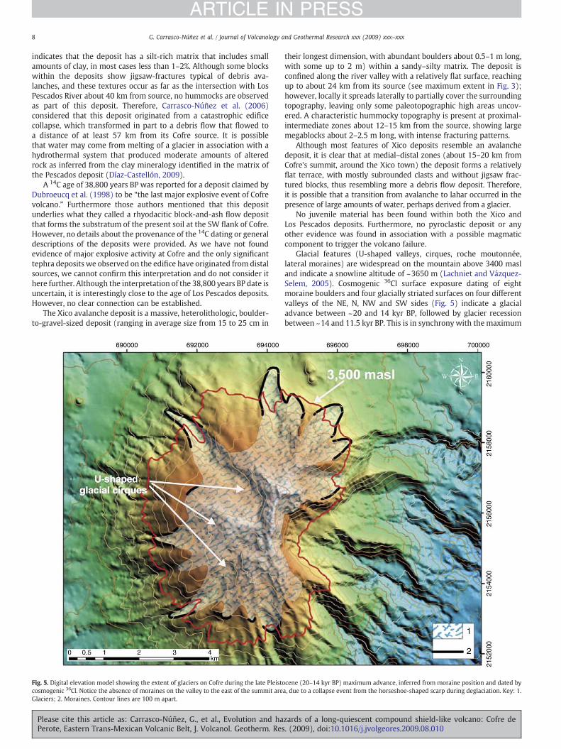
Fig. 5. Digital elevation model showing the extent of glaciers on Cofre during the late Pleistocosmogenic 36Cl. Notice the absence of moraines on the valley to the east of the summit areGlaciers; 2. Moraines. Contour lines are 100 m apart.
Please cite this article as: Carrasco-Núñez, G., et al., Evolution and haPerote, Eastern Trans-Mexican Volcanic Belt, J. Volcanol. Geotherm. Res
their longest dimension, with abundant boulders about 0.5–1 m long,with some up to 2 m) within a sandy–silty matrix. The deposit isconfined along the river valley with a relatively flat surface, reachingup to about 24 km from its source (see maximum extent in Fig. 3);however, locally it spreads laterally to partially cover the surroundingtopography, leaving only some paleotopographic high areas uncov-ered. A characteristic hummocky topography is present at proximal-intermediate zones about 12–15 km from the source, showing largemegablocks about 2–2.5 m long, with intense fracturing patterns.
Although most features of Xico deposits resemble an avalanchedeposit, it is clear that at medial–distal zones (about 15–20 km fromCofre's summit, around the Xico town) the deposit forms a relativelyflat terrace, with mostly subrounded clasts and without jigsaw frac-tured blocks, thus resembling more a debris flow deposit. Therefore,it is possible that a transition from avalanche to lahar occurred in thepresence of large amounts of water, perhaps derived from a glacier.
No juvenile material has been found within both the Xico andLos Pescados deposits. Furthermore, no pyroclastic deposit or anyother evidence was found in association with a possible magmaticcomponent to trigger the volcano failure.
Glacial features (U-shaped valleys, cirques, roche moutonnée,lateral moraines) are widespread on the mountain above 3400 masland indicate a snowline altitude of ~3650 m (Lachniet and Vázquez-Selem, 2005). Cosmogenic 36Cl surface exposure dating of eightmoraine boulders and four glacially striated surfaces on four differentvalleys of the NE, N, NW and SW sides (Fig. 5) indicate a glacialadvance between ~20 and 14 kyr BP, followed by glacier recessionbetween ~14 and 11.5 kyr BP. This is in synchrony with the maximum
cene (20–14 kyr BP) maximum advance, inferred from moraine position and dated bya, due to a collapse event from the horseshoe-shaped scarp during deglaciation. Key: 1.
zards of a long-quiescent compound shield-like volcano: Cofre de. (2009), doi:10.1016/j.jvolgeores.2009.08.010
9G. Carrasco-Núñez et al. / Journal of Volcanology and Geothermal Research xxx (2009) xxx–xxx
ARTICLE IN PRESS
late Pleistocene glaciation and subsequent deglatiation of Iztaccíhuatland other volcanoes located to the west (Vázquez-Selem and Heine,2004). Interestingly, moraines of this advance have been identifiedon all valleys of the mountain except on the eastern side, belowthe horseshoe-shaped amphitheater (Fig. 5). Moraine fronts extend alittle beyond the 3500 masl contour line (indicated in red in Fig. 6).
3.5. Stage V. Late Pleistocene-to-Holocene regional monogeneticvolcanism (42–0.9 kyr)
Following cessation of eruptive activity at the main Cofre edifice,cinder cones and lava flows likely related to regional monogeneticbasaltic volcanism were erupted through the lower flanks of thevolcano. At the northern flank of Cofre, there is a basaltic volcanic fieldthat Siebert and Carrasco-Núñez (2002) named the Cofre de Perotevent cluster (CPVC). The CPVC includes three main age groups, withthe oldest activity occurring at 42,000 years BP and the youngestgroup less than 2980 years BP, based on 14C dating (Siebert andCarrasco-Núñez, 2002).
Among the cinder, scoria and lava cones comprising the CPVC is ElVolcancillo, a paired cone located at about 15 km from Cofre summit.It is the youngest volcano in a roughly ENE-trending alignment ofabout dozen pyroclastic cones. El Volcancillo is the most recentvolcano in the northern part of the Citlaltépetl–Cofre range anderupted about 900 years BP (Siebert and Carrasco-Núñez, 2002). Itconsists of two overlapping cones that erupted nearly contempora-neous magmas of contrasting composition and eruptive style,producing high-effusion-rate alkaline (hawaiites and mugearites) aalava flows immediately followed by low-effusion-rate pahoehoe-calc-alkaline (basalts) lava flows. The aa hawaiite lavas have an estimatedbulk volume of 0.15 km3, in contrast to the calc-alkaline basalts, withan estimated bulk volume of about 1.3 km3. The latter traveled up to50 km from the source. This mobility was attributed to compoundtube-fed lava flows that inhibited rapid cooling, with a longerduration inferred from estimated effusion rates to be about 10 years(Siebert and Carrasco-Núñez, 2002).
Regional monogenetic volcanism has overprinted a large areaof the Cofre-Citlaltépetl range and areas to the north and east. Thisvolcanism lies at the confluence of the characteristic calc-alkalinevolcanism of the Citlaltépetl–Cofre range and most of the TMVB
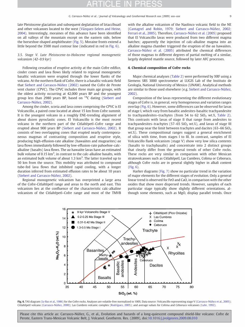
Fig. 6. TAS diagram (Le Bas et al., 1986) for the Cofre rocks. Analyses are volatile-free normalizCitlaltépetl volcano (Carrasco-Núñez, 2000); Las Cumbres volcanic complex (Rodríguez, 20
Please cite this article as: Carrasco-Núñez, G., et al., Evolution and haPerote, Eastern Trans-Mexican Volcanic Belt, J. Volcanol. Geotherm. Res
with the alkaline volcanism of the Naolinco volcanic field to the NE(Cantagrel and Robin, 1979; Siebert and Carrasco-Núñez, 2002;Ferrari et al., 2005). Therefore, Carrasco-Núñez et al. (2005) proposedthat El Volcancillo lavas were produced from two different magmabatches; apparently the injection of calc-alkaline magma into analkaline magma chamber triggered the eruption of the aa hawaiites.Carrasco-Núñez et al. (2005) attributed the chemical differencesof those magmas to different degrees of partial melting of a similar,largely depleted mantle source, followed by later AFC processes.
4. Chemical composition of Cofre rocks
Major chemical analyses (Table 2) were performed by XRF using aSiemens SRS 3000 spectrometer at LUGIS Lab of the Instituto deGeología, National University of Mexico (UNAM). Analytical methodsare similar to those used elsewhere (e.g. Siebert and Carrasco-Núñez,2002).
Composition of the lavas representing the different evolutionarystages of Cofre is, in general, very homogeneous and variation rangesoverlap (Fig. 6). However, some differences can be observed for lavasof stage I, which vary from basaltic andesites-basaltic trachyandesiteto trachyandesites–trachytes (from 54 to 62 SiO2 wt.%, Table 2).This contrasts with lavas of stage II that range from andesites totrachyandesites–trachytes (57–65 SiO2 wt.%), and lavas of stage IIIthat group near the limit between trachytes and dacites (63–66 SiO2
wt.%). These compositional ranges suggest a general enrichmentof silica with time, from stages I to III. In contrast, samples of ElVolcancillo flank volcanism (stage V) show very low silica contents(basalts to trachybasalts) and concentrate into 2 distinct groupsthat clearly differ from the general trends of other Cofre rocks.These rocks are very similar in comparison with other Mexicanstratovolcanoes such as Citlaltépetl, Las Cumbres, Colima or Ceboruco,although Cofre rocks are in general slightly higher in alkali content(Fig. 6).
Harker diagrams (Fig. 7) show no particular trend in the variationof major elements for the different stages of evolution. Only a generallinear trend is observed for FeO and CaO, in comparisonwith the otheroxides that show more dispersed trends. However, samples of eachparticular stage typically show slightly different orientations, al-though some elements, such as MgO, display parallel trends. Once
ed to 100%. Data source: Volcancillo representing stage V (Carrasco-Núñez et al., 2005);05); and average values for Colima and Ceboruco volcanoes (Luhr, 1992).
zards of a long-quiescent compound shield-like volcano: Cofre de. (2009), doi:10.1016/j.jvolgeores.2009.08.010
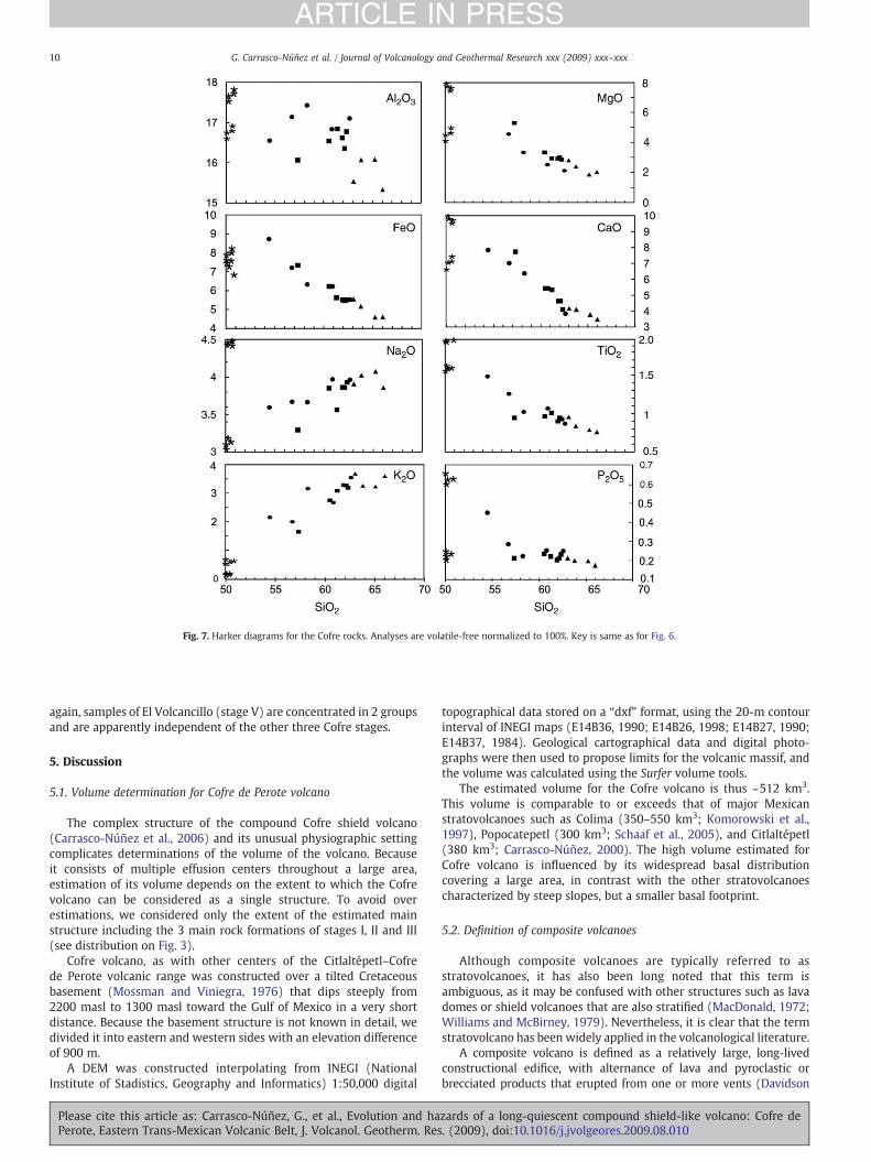
Fig. 7. Harker diagrams for the Cofre rocks. Analyses are volatile-free normalized to 100%. Key is same as for Fig. 6.
10 G. Carrasco-Núñez et al. / Journal of Volcanology and Geothermal Research xxx (2009) xxx–xxx
ARTICLE IN PRESS
again, samples of El Volcancillo (stage V) are concentrated in 2 groupsand are apparently independent of the other three Cofre stages.
5. Discussion
5.1. Volume determination for Cofre de Perote volcano
The complex structure of the compound Cofre shield volcano(Carrasco-Núñez et al., 2006) and its unusual physiographic settingcomplicates determinations of the volume of the volcano. Becauseit consists of multiple effusion centers throughout a large area,estimation of its volume depends on the extent to which the Cofrevolcano can be considered as a single structure. To avoid overestimations, we considered only the extent of the estimated mainstructure including the 3 main rock formations of stages I, II and III(see distribution on Fig. 3).
Cofre volcano, as with other centers of the Citlaltépetl–Cofrede Perote volcanic range was constructed over a tilted Cretaceousbasement (Mossman and Viniegra, 1976) that dips steeply from2200 masl to 1300 masl toward the Gulf of Mexico in a very shortdistance. Because the basement structure is not known in detail, wedivided it into eastern and western sides with an elevation differenceof 900 m.
A DEM was constructed interpolating from INEGI (NationalInstitute of Stadistics, Geography and Informatics) 1:50,000 digital
Please cite this article as: Carrasco-Núñez, G., et al., Evolution and haPerote, Eastern Trans-Mexican Volcanic Belt, J. Volcanol. Geotherm. Res
topographical data stored on a “dxf” format, using the 20-m contourinterval of INEGI maps (E14B36, 1990; E14B26, 1998; E14B27, 1990;E14B37, 1984). Geological cartographical data and digital photo-graphs were then used to propose limits for the volcanic massif, andthe volume was calculated using the Surfer volume tools.
The estimated volume for the Cofre volcano is thus ~512 km3.This volume is comparable to or exceeds that of major Mexicanstratovolcanoes such as Colima (350–550 km3; Komorowski et al.,1997), Popocatepetl (300 km3; Schaaf et al., 2005), and Citlaltépetl(380 km3; Carrasco-Núñez, 2000). The high volume estimated forCofre volcano is influenced by its widespread basal distributioncovering a large area, in contrast with the other stratovolcanoescharacterized by steep slopes, but a smaller basal footprint.
5.2. Definition of composite volcanoes
Although composite volcanoes are typically referred to asstratovolcanoes, it has also been long noted that this term isambiguous, as it may be confused with other structures such as lavadomes or shield volcanoes that are also stratified (MacDonald, 1972;Williams and McBirney, 1979). Nevertheless, it is clear that the termstratovolcano has been widely applied in the volcanological literature.
A composite volcano is defined as a relatively large, long-livedconstructional edifice, with alternance of lava and pyroclastic orbrecciated products that erupted from one or more vents (Davidson
zards of a long-quiescent compound shield-like volcano: Cofre de. (2009), doi:10.1016/j.jvolgeores.2009.08.010
11G. Carrasco-Núñez et al. / Journal of Volcanology and Geothermal Research xxx (2009) xxx–xxx
ARTICLE IN PRESS
and de Silva, 2000). This type of volcano includes not only the classicalsimple cones with steep slopes, a typical conical shape with a singlesummit vent, and radial topography, but also a more complexmorphology attributed to differences in growth patterns. Differentevolutionary stages involve repetitive constructional and destructionalepisodes, as well as changes of the dominant volcanic material such aslavas, pyroclastic or breccia deposits, variations in chemical compositionand possible vent migration.
A variety of composite volcano is a compound volcano, whichis defined as a volcanic massif formed from coalesced products ofmultiple, closely spaced vents (Davidson and de Silva, 2000).Examples of these volcanoes are: Mt. Ruapehu in New Zealand andLascar in Chile. These volcano morphologies were described byRittman (1962), but referred to earlier as multiple volcanoes (Cotton,1944). However, it is important that they must be considered tohave an individual identity, in contrast with volcano complexes, thatinclude extensive assemblages or clusters of major and/or minorcenters with associated lavas and pyroclastic rocks (Francis, 1994)that in many instances are aligned to form a prominent volcanicrange.
On the other hand, shield-like composite volcanoes exhibitshallow-sloped flanks and are dominated by effusive products andtend to develop forms intermediate between domes and actual shieldvolcanoes (Williams and McBirney, 1979).
5.3. What type of volcano is Cofre de Perote ?
Commonly Cofre has been regarded due to its size as a compositevolcano (typical Mexican stratovolcano) such as Citlaltépetl, LaMalinche or Popocatépetl. However, it displays significant differences.Instead of having a conical shape typical of a stratocone with steepslopes, Cofre morphologically exhibits a low profile with gentle slopesresembling a shield volcano (Fig. 2A), and it is almost whollydominated by lava flows. Furthermore, it is clear that during theconstruction of the edifice, Cofre volcanic products were not eruptedthrough a single conduit. Rather, different overlapping vents acted asmain vents, not as parasitic or minor vents that are usually fed insingle composite volcanoes through fissure systems connected to amain eruptive conduit.
The massive Cofre shield volcano appears to be unusual amongthe Quaternary volcanoes of the Trans-Mexican Volcanic Belt. Twomassive, low-angle volcanoes at the northern end of the Popocatépetl–Iztaccíhuatl volcanic chain, Tláloc (García-Palomo et al., 2002) andTelapón, have somewhat similar morphologies, but have a more ex-plosive component. In fact, Iztaccíhuatl volcano (Nixon, 1989) seems tobe an intermediate case in between the “typical Mexican stratovolcano”and the shield-like Cofre.
Cofre differs dramatically in scale from the numerous smallershield volcanoes of the TMVB found in themonogenetic volcanic fieldsof Sierra de Chichinautzin (Martin del Pozzo, 1982; Márquez et al.,1999) and Michoacán-Guanajuato (Hasenaka, 1994). Shield volca-noes of Michoacán-Guanajuato range from 0.5 km3 to 54 km3, witha mean average volume of 1.7 km3 (Hasenaka, 1994), and are similarin size to Icelandic-style shield volcanoes. Cofre, in contrast, has avolume of >500 km3, several orders of magnitude larger.
The massive size of Cofre is somewhat comparable to that of900 km3 Mount Wrangell in Alaska, one of the world's largestandesitic volcanoes (Nye, 1990; Richter et al., 1990). This 4317-m-high, glacier-covered shield volcano likewise dominantly consists offluid lava flows rather than pyroclastic rocks. The two volcanoes, onecurrently glaciated and the other previously ice-covered, havestructural and geochemical similarities. Both volcanoes form broad,low-angle shield volcanoes with multiple conduits and are about 30–40 km wide and have low-angle profiles, with slope angles about 10°or less. Despite their low-angle slopes, both volcanoes haveundergone major edifice failure, producing the Xico and Los Pescados
Please cite this article as: Carrasco-Núñez, G., et al., Evolution and haPerote, Eastern Trans-Mexican Volcanic Belt, J. Volcanol. Geotherm. Res
debris avalanches at Cofre (Carrasco-Núñez et al., 2006) and theChetaslina mass flow at Wrangell (Waythomas and Wallace, 2002).The two volcanoes lie in areas of complex tectonism. Wrangell, andthe nearby large Sanford and Tanada andesitic shield volcanoes, wasconstructed at the junction of Aleutian volcanic arc subduction and astrike-slip transform fault system on the east forming the boundarybetween the North American and Pacific tectonic plates (Richter et al.,1990). Cofre lies at the far eastern end of the TMVB, at the intersectionof the oblique, more shallow subduction component of the Cocos Plate(Pardo and Suárez, 1995) with the Northern Mexican ExtensionalProvince dominated by more alkalic magmas (Luhr et al., 2006).
Both volcanoes range from basaltic andesite to dacitic compositionand displaymedium-K calc-alkaline affinities, including trachyandesiticto trachytic rocks. Despite their relatively high-silica lavas, both Cofreand Wrangell have produced large-volume, porphyritic, but fluid lavaflows that traveled long distances over low-angle slopes. The fluidity ofthe flows atWrangell was attributed by Nye (1990) not to anomalouslyhigh temperature or alkalic geochemistry, or low phenocryst content,but to high effusion rates similar to what produced the high fluidity ofColumbia River basalts.
Regional structural factors and irregularities of the substratethrough which magmas ascend to the surface may have influencedthe evolution and morphology of Cofre. The volcano lies in atransitional area connecting the end of the easternmost typicallycalc-alkaline volcanic range of the TMVB with the Naolinco volcanicfield (Siebert and Carrasco-Núñez, 2002), which is characterized byalkaline volcanism ranging from Pliocene to the Holocene. Theprincipal edifice-forming phases at Cofre took place in the middlepart of a NE alignment (Fig. 1), an apparently dominant structuralpattern that connects with the Naolinco volcanic field through a ENEalignment of cones where 900 years BP El Volcancillo occupies its SWend. This ENE trend is parallel to the Huitzilapan fracture (Fig. 1),which is related to the 1920 earthquake (Camacho and Flores, 1922),and therefore is considered as an active system. The interactionbetween the N–S trending structural pattern followed by theCitlaltépetl–La Gloria volcanoes to the south with the NE-trendingfractures could have enhanced the number of available secondaryconduit paths. Thismay have allowedmagma ascent throughmultipleconduits, forming the large-volume, low-angle compound shieldvolcano rather than concentrating eruptive activity through a singleconduit as typical of stratovolcanoes.
The original low-angle flank morphology of Cofre volcano with acharacteristic multi-vent magmatic system was modified by glacialerosion (Lachniet and Vázquez-Selem, 2005) and by catastrophicevents that affected its summit area. Evidence for that is representedby the prominent set of scarps that in combination show a spectacularhorseshoe-shaped amphitheater linked to repetitive flank failures.Cofre distinctly contrasts with a stratovolcano as it resulted froma combination of different volcano types and must be regarded asa compound shield-like volcano with a collapse-scared, modifiedmorphology.
5.4. Instability at Cofre
Multiple edifice-collapse events have been identified along theCCVR, including Citlaltépetl, Las Cumbres and Cofre volcanoes. All ofthem have preferentially been directed eastward towards the Gulfof Mexico coast, and Carrasco-Núñez et al. (2006) proposed thatthey were mainly controlled by the sloping substrate, and favored byother instability factors such as abrupt relief, tectonic setting, andhydrothermal alteration. However, these instability factors have acteddifferently on those volcanoes, as they have different morphologies,structural features and degrees of alteration.
In contrast with Citlaltépetl volcano that has very steep slopes andevident unstable conditions, Cofre exhibits a low-angle profile thatsuggests apparent stable conditions; however, the truncated eastern
zards of a long-quiescent compound shield-like volcano: Cofre de. (2009), doi:10.1016/j.jvolgeores.2009.08.010
12 G. Carrasco-Núñez et al. / Journal of Volcanology and Geothermal Research xxx (2009) xxx–xxx
ARTICLE IN PRESS
side and associated flank failure deposits indicate repetitive large-scale edifice collapses. This phenomenon has been observed atother low-angle volcanoes such as oceanic shields in Hawaii (Mooreet al., 1989) and the Canary Islands (Carracedo et al., 1999), as well asat another continental margin shield volcano similar to Cofre, MountWrangell (Nye, 1990; Waythomas and Wallace, 2002).
It is evident that there is an important structural control on theCofre collapsing events, strongly influenced by the slope of theunderlying sedimentary Mesozoic basement, which shows a “down-dropped” displacement toward the coastal plain, producing flankfailures that were directed to the SE. Modelling by Wooller et al.(2004) noted the influence of very low-angle basement slopes onedifice deformation and failure direction. Edifice failures at Cofre areperpendicular to the La Gloria–Cofre–Las Lajas alignment (Fig. 1);however, there are not superficial expressions of any type of faulting.This is consistent with observations by Moriya (1980) and Siebert(1984) that extension resulting from repetitive dike intrusionsparallel to the maximum horizontal compressive stress direction(Nakamura, 1977) preferentially produces edifice failures perpendic-ular to that direction.
Hydrothermal alteration has been identified as another importantfactor causing progressive weakening on the upper parts of volcanoes(e.g. Frank, 1983; Carrasco-Núñez et al., 1993; Crowley and Zimbel-man, 1997). Although Cofre shows different areas of moderate argillicalteration both at the summit amphitheater and in the Xico and LosPescados deposits (Díaz-Castellón, 2009; Díaz-Castellón et al.,unpublished data), these are not as extensive as on Citlaltépetl,where alteration greatly reduced edifice strength. Nevertheless, weconsider that Cofre's moderate alteration favored a general weaken-ing of its upper parts that promote instability conditions for a sectorcollapse event.
It has been proposed that hydrothermal alteration can be en-hanced in the presence of an active glacier (Carrasco-Núñez et al.,1993) and that under extreme conditions, voluminous debrisavalanche-induced cohesive lahars can originate, as at Citlaltépetlvolcano. Although, no cohesive lahars are reported for Cofre, we canbriefly discuss here the importance of glaciation on the evolution ofCofre. The glacial record of central Mexico (Vázquez-Selem and Heine,2004) and the deep imprint of glacial processes on the upper partof Cofre suggest that the mountain underwent extensive glaciationat least twice. Products of the final phase of edifice construction(stage III, 0.25–0.2Ma)were likely eroded by amarked pre-Wisconsinglacial advance identified in other mountains of central Mexico(~195 kyr BP, Vázquez-Selem andHeine, 2004). In the late Pleistocene(20–14 kyr BP), an ice cap with radiating valley glaciers developedagain on the Cofre's summit area. The absence of late-Pleistocenemoraines below the horseshoe-shaped amphitheater to the east of thesummit suggests that a collapse event took place on that sector of themountain after the peak of glaciation. Since the 36Cl ages of glacierrecession (~14–11.5 kyr BP) and the 14C ages of the Xico collapse (13–11 kyr BP) overlap, it is possible that deglaciation contributed tothe latter event, by providing abundant meltwater increasing porepressure, or by load discharge, or debuttressing as postulated by Capra(2006) for other volcanoes. In the case of Los Pescados debris flow,there is no conclusive evidence of glacial advances at that time,although minimum ages of tills from La Malinche, Ajusco and Nevadode Toluca suggest the possibility of glaciation prior to 30 kyr BP on themountains of central Mexico (Vázquez-Selem and Heine, 2004).
5.5. Triggering mechanisms for collapse events
Considering the scarcity of exposures and thus information aboutthe ancient collapse event affecting rock of stage I, we concentrate thediscussion only on the most recent Xico and Los Pescados deposits. Itis very clear that these deposits (Xico and Los Pescados) representsector collapse events at Cofre that occurred long after the cessation of
Please cite this article as: Carrasco-Núñez, G., et al., Evolution and haPerote, Eastern Trans-Mexican Volcanic Belt, J. Volcanol. Geotherm. Res
activity and therefore resulted from non-magmatic triggeringmechanisms. Even though instability at Cofre could develop progres-sively over long periods of time by structural weakening, moderatehydrothermal alteration and/or weathering processes, the processcould have been accelerated by a sudden event such as an earthquakeand/or extraordinary periods of heavy rainfall during hurricaneevents. The region around Cofre is seismically active and has occa-sionally extraordinarily high rainfall rates, so both agents couldinfluence collapse, singly or in combination.
Rainfall has been invoked as a triggering mechanism for manysmall-volume non-volcanic and volcanic landslides, such as the 1998collapse of Casita volcano in Nicaragua (Van Wyk de Vries et al.,2000; Scott et al., 2005). Although, rainfall is a very active agent inthe area around Cofre, causing some instability conditions, thismay be insufficient to remobilize large volumes of rocks with deep-seated failure planes from the Cofre summit. On the other hand,considering the area is seismically active as seen by the strong 1920sXalapa earthquake (Camacho and Flores, 1922), sudden strongseismic activity could be a principal trigger for both catastrophicevents (Los Pescados and Xico). This is in accordance with thestability analysis made by Díaz-Castellón (2009), who proposed thatan earthquake of magnitude greater than 6 with an epicenter nearthe volcano can be sufficient to trigger the failure of an unstableedifice such as Cofre.
5.6. Hazard implications
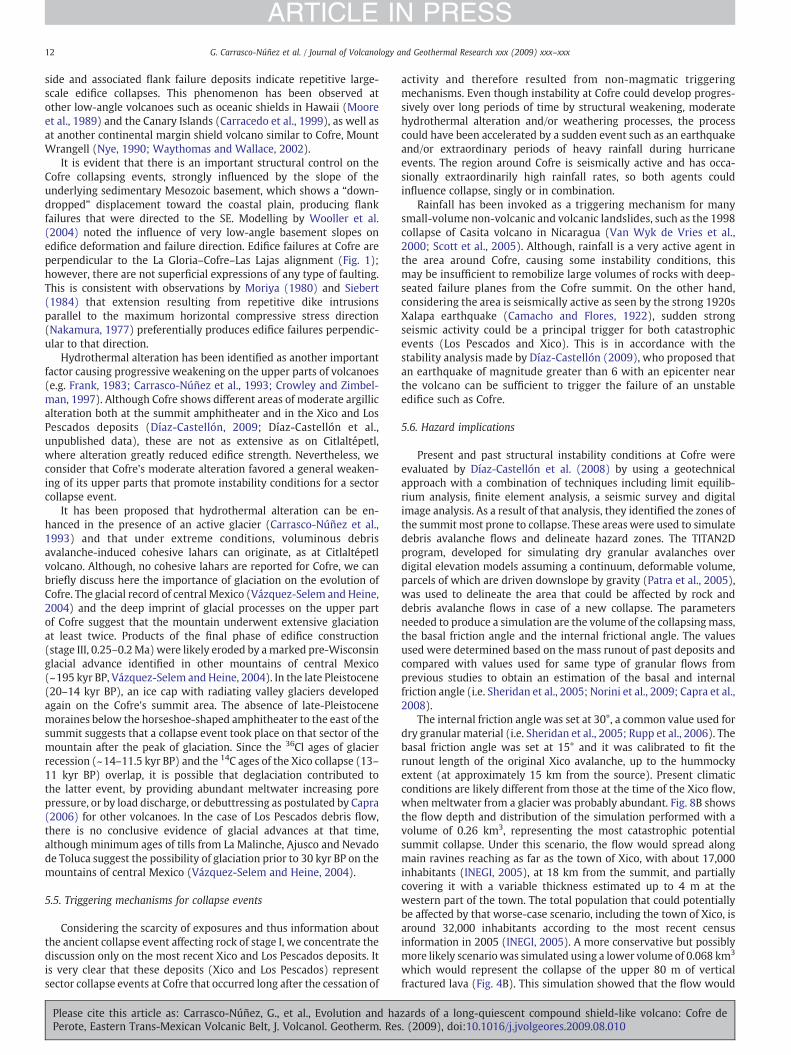
Present and past structural instability conditions at Cofre wereevaluated by Díaz-Castellón et al. (2008) by using a geotechnicalapproach with a combination of techniques including limit equilib-rium analysis, finite element analysis, a seismic survey and digitalimage analysis. As a result of that analysis, they identified the zones ofthe summit most prone to collapse. These areas were used to simulatedebris avalanche flows and delineate hazard zones. The TITAN2Dprogram, developed for simulating dry granular avalanches overdigital elevation models assuming a continuum, deformable volume,parcels of which are driven downslope by gravity (Patra et al., 2005),was used to delineate the area that could be affected by rock anddebris avalanche flows in case of a new collapse. The parametersneeded to produce a simulation are the volume of the collapsingmass,the basal friction angle and the internal frictional angle. The valuesused were determined based on the mass runout of past deposits andcompared with values used for same type of granular flows fromprevious studies to obtain an estimation of the basal and internalfriction angle (i.e. Sheridan et al., 2005; Norini et al., 2009; Capra et al.,2008).
The internal friction angle was set at 30°, a common value used fordry granular material (i.e. Sheridan et al., 2005; Rupp et al., 2006). Thebasal friction angle was set at 15° and it was calibrated to fit therunout length of the original Xico avalanche, up to the hummockyextent (at approximately 15 km from the source). Present climaticconditions are likely different from those at the time of the Xico flow,when meltwater from a glacier was probably abundant. Fig. 8B showsthe flow depth and distribution of the simulation performed with avolume of 0.26 km3, representing the most catastrophic potentialsummit collapse. Under this scenario, the flow would spread alongmain ravines reaching as far as the town of Xico, with about 17,000inhabitants (INEGI, 2005), at 18 km from the summit, and partiallycovering it with a variable thickness estimated up to 4 m at thewestern part of the town. The total population that could potentiallybe affected by that worse-case scenario, including the town of Xico, isaround 32,000 inhabitants according to the most recent censusinformation in 2005 (INEGI, 2005). A more conservative but possiblymore likely scenariowas simulated using a lower volume of 0.068 km3
which would represent the collapse of the upper 80 m of verticalfractured lava (Fig. 4B). This simulation showed that the flow would
zards of a long-quiescent compound shield-like volcano: Cofre de. (2009), doi:10.1016/j.jvolgeores.2009.08.010
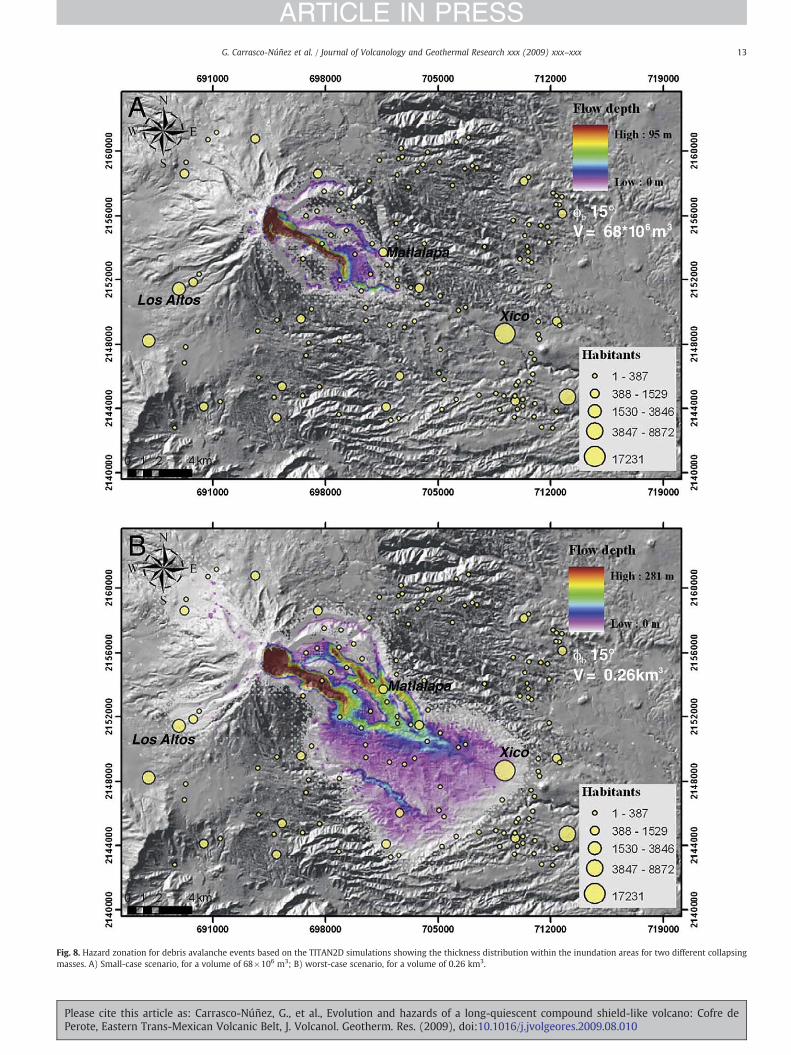
Fig. 8. Hazard zonation for debris avalanche events based on the TITAN2D simulations showing the thickness distribution within the inundation areas for two different collapsingmasses. A) Small-case scenario, for a volume of 68×106 m3; B) worst-case scenario, for a volume of 0.26 km3.
13G. Carrasco-Núñez et al. / Journal of Volcanology and Geothermal Research xxx (2009) xxx–xxx
ARTICLE IN PRESS
Please cite this article as: Carrasco-Núñez, G., et al., Evolution and hazards of a long-quiescent compound shield-like volcano: Cofre dePerote, Eastern Trans-Mexican Volcanic Belt, J. Volcanol. Geotherm. Res. (2009), doi:10.1016/j.jvolgeores.2009.08.010
14 G. Carrasco-Núñez et al. / Journal of Volcanology and Geothermal Research xxx (2009) xxx–xxx
ARTICLE IN PRESS
fill ravines only in proximal areas up to a distance of 8 km (Fig. 8A),affecting only around 2600 inhabitants. It is important tomention thatboth scenarios imply the destruction of the telecommunicationantennas at Cofre's summit.
Finally, it is important to emphasize that the failure of a volcanicedifice can occur without warning. This is particularly the case wherethere is clear evidence of unstable conditions promoted by irregularsloping basement, high gravitational gradients, strong stress regime,intense fracturing, moderate hydrothermally altered rocks, andwater-saturated conditions by melting water from deglaciation. Inthese cases, collapse can be triggered by non-magmatic factors such asseismicity, unusual rainfall or by destabilization associated with thehydrothermal system, with seismicity being the most likely triggeringagent (McGuire, 1996).
Although the main Cofre edifice is an apparently extinct volcano,the Holocene activity of El Volcancillo (0.9 kyr BP) at the Cofre's lowerflanks, and the active seismicity of the area, reveal that the regionalmagma-tectonic system is active and hazards from new volcanicactivity cannot be excluded at all, particularly at the northern flanks ofCofre. An interesting observation that supports this idea, is that ElVolcancillo formed at the SE end of an alignment of several cindercones parallel to the Huitzilapan fracture that was apparentlyreactivated during the 1920 Xalapa earthquake.
6. Conclusions
Based on its morphology (gentle slopes with no steep-sidededifice), dominant material type (entirely lava flows), and mainconduit characteristics (comprising several vents instead of a single
Fig. 9. Evolutionary stages of Cofre: A) initial formation of the basal volcanic complex (stage Irocks. This was partially covered by the Xaltipan ignimbrite, and a sector collapse event endC) final construction of the Cofre compound shield-like volcano through multiple conduits (and debris avalanche deposits emplaced toward the SE (marked with a thin line over the l
Please cite this article as: Carrasco-Núñez, G., et al., Evolution and haPerote, Eastern Trans-Mexican Volcanic Belt, J. Volcanol. Geotherm. Res
main conduit), Cofre must be considered as a new type of hybridvolcano, referred to as a compound shield-like volcano, and not as astratovolcano as it has been commonly regarded.
The evolution of Cofre compound volcano occurred in 5 differentstages summarized in Fig. 9, which include: 1) construction of amultiple-vent dome complex around 1.3–0.51 Ma, and sectorcollapse; 2) construction of the basal part of the compound shieldvolcano from at least two main upper-edifice vents at about 0.42–0.31 ka; 3) final effusion of the summit dome-like lavas throughmultiple vents at ca. 0.24 Ma; 4) episodic non-magmatic-induced,large-volume edifice collapse (ca. 40 ka and ca. 13–11 ka), producinglong-runout debris avalanches and flows, the most recent case beingcoeval to deglaciation; 5) regional monogenetic activity with theeruption of both alkaline and calc-alkaline Pleistocene-to-Holocenemonogenetic cones through the flanks of the Cofre edifice.
Even though hazards associated with volcanic activity are unlikelyfor a long-quiescent volcano such as Cofre, eruption of new parasiticvolcanoes on the lower slopes of its volcanic edifice are possible asoccurred in prehistoric times with the 900 years BP eruption of ElVolcancillo on its northern flank.
Although its geological evolution produced a morphology suggest-ing adequate stability conditions, the Cofre volcanic edifice hascollapsed repetitively, indicating strong instability. Furthermore,these catastrophic collapses occurred without apparent magmaticactivity, which has important implications for hazard assessmentpurposes, as the possibility that one of these non-eruptive eventscould occur in the future cannot be excluded.
The hazard zones shown here for Cofre volcano indicate twodifferent scenarios. One is for a small but more likely sector collapse
) over an irregular topography dominated by a faulted and foldedMesozoic sedimentaryed this stage; B) construction of the ancient Cofre shield-like volcanic edifice (stage II);stage III); and D) multiple collapse events (stage IV) forming scarps at the summit areaavas of stage III. Volcanism representing stage V is not depicted here.
zards of a long-quiescent compound shield-like volcano: Cofre de. (2009), doi:10.1016/j.jvolgeores.2009.08.010
15G. Carrasco-Núñez et al. / Journal of Volcanology and Geothermal Research xxx (2009) xxx–xxx
ARTICLE IN PRESS
event that could only affect very small villages located at the upperslopes of Cofre, and the other for a worse-case scenario, where thedebris avalanche could reach the town of Xico, the largest city alongthe avalanche inundation area, with about 17,000 inhabitants,affecting a total of nearly 32,000 inhabitants.
Acknowledgments
We dedicate this paper to Jim Luhr, whose interest in Mexicanvolcanoes led to very fruitful discussions at the beginning of this studythat provided important ideas for this paper. Funding to perform thiswork came from CONACYT grant 44549-F and UNAM-PAPIIT grantIN107905 to GCN; and from CONACYT grant 50780-F and UNAM-PAPIIT grant IN111206 to LVS. J.L. Rodríguez helped with field and labwork. Logistic support was provided by Centro de Geociencias(UNAM). Manuel Albarrán helped with the sample preparation, andthin sections were made by Juan Vázquez; chemical analyzes wereperformed by Rufino Lozano at Instituto de Geología (UNAM). Initialfield work and discussion with Steve Nelson is much appreciated.Reviews by C. Waythomas, G. Boudon and guest editor J.L. Macíasprovided important insights that greatly improved this paper.
References
Camacho, H., Flores, T., 1922. Memoria relativa al TerremotoMexicano del 3 de enero de1920. Bol. Inst. Geol. Méx. 38–39 107 pp.
Cantagrel, J.M., Robin, C., 1979. K–Ar dating on eastern Mexican volcanic rocks;relations between the andesitic and the alkaline provinces. J. Volcanol. Geotherm.Res. 5, 99–114.
Capra, L., 2006. Abrupt climatic changes as triggering mechanisms of massive volcaniccollapses. J. Volcanol. Geotherm. Res. 155 (3–4), 329–333.
Capra, L., Norini, G., Groppelli, G., Macías, J.L., Arce, J.L., 2008. Volcanic hazard zonationof Nevado de Toluca Volcano. J. Volcanol. Geotherm. Res. 176, 469–484.
Carracedo, J.C., Day, S.J., Guillou, H., Perez-Torrado, F.J., 1999. Giant Quaternarylandslides in the evolution of La Plama and El Hierro, Canary Islands. J. Volcanol.Geotherm. Res. 94, 169–190.
Carrasco-Núñez, G., 2000. Structure and proximal stratigraphy of Citlaltépetl Volcano(Pico de Orizaba), Mexico. Cenozoic Volcanism and Tectonics of Mexico. Geol. Soc.Am. Spec. Pap. 334, 247–262.
Carrasco-Núñez, G., Nelson, S., 1998. Edad y tasa de crecimiento del Volcán Cofre de PerotePrimera Reunión Nacional de Ciencias de la Tierra, México D.F. Abstract Volume.
Carrasco-Núñez, G., Vallance, J.W., Rose, W.I., 1993. A voluminous avalanche-inducedlahar from Citlaltépetl volcano, México: implications for hazard assessment.J. Volcanol. Geotherm. Res. 59, 35–46.
Carrasco-Núñez, G., Gómez-Tuena, A., Lozano, L., 1997. Geologic Map of Cerro GrandeVolcano and Surrounding Area, Central Mexico: Geol. Soc. Am. Map and ChartSeries MCH, vol. 081. 10 pp.
Carrasco-Núñez, G., Righter, K., Chesley, J., Siebert, L., Aranda-Gómez, J.J., 2005.Contemporaneous eruption of calc-alkaline and alkaline lavas in a continental arc(Eastern Mexican Volcanic Belt): chemically heterogeneous but isotopicallyhomogeneous source. Contrib. Mineral. Petrol. 150, 423–440.
Carrasco-Núñez, G., Díaz-Castellón, R., Siebert, L., Hubbard, B., Sheridan,M.F., Rodríguez,S.R., 2006.Multiple edifice-collapse events in the EasternMexican Volcanic Belt: therole of sloping substrate and implications for hazard assessment. In: Tibaldi, A.,Lagmay, A. (Eds.), The Effects of Basement Structural and Stratigraphic Heritages onVolcano Behavior: J. Volcanol. Geotherm. Res., vol. 158, pp. 151–176.
Concha-Dimas, A., Cerca, M., Rodríguez, S.R., Watters, R.J., 2005. Geomorphologicalevidence of the influence of pre-volcanic basement structure on emplacement anddeformation of volcanic edifices at the Cofre de Perote–Pico de Orizaba chain andimplications for avalanche generation. Geomorphology 72, 19–39.
Cotton, C.A., 1944. Volcanoes as landscape forms.Whitecombe andTombs, Christchurch,New Zealand. 415 pp.
Crowley, J.K., Zimbelman, D.R., 1997. Mapping hydrothermally altered rocks on MountRainier, Washington, with airborn visible/infared imaging spectrometer (AVIRIS)data. Geology 25, 559–562.
Davidson, J., de Silva, S., 2000. Composite volcanoes. In: Sigurdsson, H. (Ed.), Encyclopediaof Volcanoes. Academic Press, pp. 663–681.
Demant, A., 1978. Características del Eje Neovolcánico Transmexicano y sus problemasde interpretación. Universidad Nacional Autónoma de México. Instituto de Geología.Revista 2, 172–187.
Díaz-Castellón, R., 2009. Análisis de las condiciones estructurales en el Cofre de Perote.Ph.D. Thesis, Posgrado en Ciencias de la Tierra, UNAM, Mexico, 217 pp.
Díaz-Castellón, R., Carrasco-Núñez, G., Alvarez-Manilla, A., 2008. Mechanical instabilityquantification of slopes at Cofre de Perote volcano, eastern Mexico. Bol. Soc. Geol.Mex. 58 (2), 187–201.
Dubroeucq, D., Geissert, D., Quantin, P., 1998. Weathering and soil forming processesunder semi-arid conditions in two Mexican volcanic ash soils. Geoderma 86,99–122.
Please cite this article as: Carrasco-Núñez, G., et al., Evolution and haPerote, Eastern Trans-Mexican Volcanic Belt, J. Volcanol. Geotherm. Res
Ferrari, L., López-Martínez, M., Aguirre-Díaz, G., Carrasco-Núñez, G., 1999. Space–timepatterns of Cenozoic arc volcanism in Central Mexico: from the Sierra MadreOccidental to the Mexican Volcanic Belt. Geology 27 (4), 303–306.
Ferrari, L., Tagami, T., Eguchi, M., Orozco-Esquivel, T., Petrone, C., Jacobo-Albarrán, J.,López-Martínez, M., 2005. Geology, geochronology and tectonic setting of lateCenozoic volcanism along the southwestern Gulf of Mexico: the Eastern AlkalineProvince revisited. J. Volcanol. Geotherm. Res. 146, 284–306.
Ferriz, H., Mahood, G., 1984. Eruptive rates and compositional trends at Los Humerosvolcanic center, Puebla, Mexico. J. Geophys. Res. B89, 8511–8524.
Francis, P., 1994. Volcanoes, a Planetary Perspective. Oxford University Press, Oxford.443 pp.
Frank, D., 1983. Origin, distribution, and rapid removal of hydrothermally formed clayat Mount Baker, Washington. U.S. Geol. Surv. Prof. Pap. 1022-E 131 pp.
García-Palomo, A., Macías, J.L., Tolson, G., Valdez, G., Mora, J.C., 2002. Volcanicstratigraphy and geological evolution of the Apan region, east-central sector ofthe Trans-Mexican Volcanic Belt. Geofís. Int. 41 (2), 133–150.
Hasenaka, T., 1994. Size, distribution, andmagma output rate for shield volcanoes of theMichoacan–Guanajuato volcanic field, Central Mexico. J. Volcanol. Geotherm. Res.63, 13–31.
INEGI, 2005. II Conteo de población y vivienda 2005: México y sus municipios. WWWPage, http://www.inegi.org.mx/prod_serv/contenidos/espanol/bvinegi/productos/integracion/municipios/mexympios/MexIICon_1.pdf.
Komorowski, J.C., Navarro, C., Cortes, A., Saucedo, R., Gavilanes, J.C., Siebe, C., Espindola,J.M., Rodriguez, S., 1997. The Colima volcanic complex: part I: Quaternary multipledebris-avalanche deposits, part II: historical pyroclastic sequences (1913, 1991,1994). IAVCEI General Assembly, Puerto Vallarta, Mexico, January 19–24, 1997.Fieldtrip Guidebook, Excursion No. 3.
Lachniet, M.S., Vázquez-Selem, L., 2005. Last glacial maximum equilibrium linealtitudes in the circum-Caribian (Mexico, Guatemala, Costa Rica, Colombia, andVenezuela). Quarter. Inter. 138–139, 129–144.
Le Bas, M.J., Le Maitre, R.W., Streckeinsen, A., Zanettin, B., 1986. A chemical classificationof volcanic rocks based on total alkali–silica diagram. J. Petrol. 77, 24–37.
Lozano, L., Carrasco-Núñez, G., 2000. Evidencias de colapso sectorial del Volcán Cofrede Perote. 7th Reunión Internacional del volcán de Colima, Colima, Mexico, p. 68.abstract volume.
Luhr, J., 1992. Slab-derived fluids and partial meeting in subduction zones: insights fromtwo contrasting Mexican volcanoes (Colima and Ceboruco). J. Volcanol. Geotherm.Res. 54, 1–18.
Luhr, J.F., Kimberly, P., Siebert, L., Aranda-Gomez, J.J., Housh, T.B., Kysar Mattietti, G.,2006. México's Quaternary volcanic rocks: insights from the MEXPET petrologicaland geochemical database. In: Siebe, C., Macías, J.L., Aguirre-Díaz, G.J. (Eds.),Neogene–Quaternary Continental Margin Volcanism—A Perspective from México:Geol. Soc. Am., Spec. Pap., vol. 402. 44 pp.
MacDonald, G., 1972. Volcanoes. Prentice Hall, New Jersey. 463 pp.Márquez, A., Verma, S.P., Anguita, F., Oyarzun, R., Brandle, J.L., 1999. Tectonics and
volcanism of Sierra Chichinautzin: extension at the front of the Central Trans-Mexican Volcanic Belt. J. Volcanol. Geotherm. Res. 93, 125–140.
Martin del Pozzo, A.L., 1982. Monogenetic volcanism in Sierra Chichinautzin, Mexico.Bull. Volcanol. 45, 9–24.
McGuire, W.J., 1996. Volcano instability: a review of contemporary themes. In: McGuire,W.J., Jones, A.P., Neuberg, J. (Eds.), Volcano Instability on the Earth and Other Planets:Geological Society Special Publication, vol. 110, pp. 1–23.
Moore, J.G., Clague, D.A., Holcomb, R.T., Lipman, P.W., Normark, W.R., Torresan, M.E.,1989. Prodigious submarine landslides on the Hawaiian Ridge. J. Geophys. Res. 94,17,465–17,484.
Moriya, I., 1980. Bandaian eruption and landforms associated with it. Collection ofArticles in Memory of Retirement of Prof. K. Nishimura. Tohoku University, Sendai,pp. 214–219.
Mossman, R.W., Viniegra, F., 1976. Complex fault structures in Veracruz Province ofMexico. Am. Assoc. Pet. Geol. Bull. 60 (3), 379–388.
Nakamura, K., 1977. Volcanoes as possible indicators of tectonic stress. J. Volcanol.Geotherm. Res. 2, 1–16.
Negendank, J.F.W., Emmermann, R., Krawczyk, R., Mooser, F., Tobschall, H., Werle, D.,1985. Geological and geochemical investigations on the Eastern Trans-MexicanVolcanic Belt. Geofis. Int. 24–4, 477–575.
Nixon, G.T., 1989. The Geology of Iztaccíhuatl volcano and adjacent areas of the SierraNevada and Valley of Mexico. Geol. Soc. Am. Spec. Pap. 219 58 pp.
Norini, G., De Beni, E., Andronico, D., Polacci, M., Burton, M., Zucca, F., 2009. The 16November 2006 flank collapse of the south-east crater at Mount Etna, Italy: study ofthe deposit and hazard assessment. J. Geophys. Res. 114, B02204. doi:10.1029/2008JB005779.
Nye, C.J., 1990. Wrangell. In: Wood, C.A., Kienle, J. (Eds.), Volcanoes of North America,United States and Canada. Cambridge Univ. Press, Cambridge, England, pp. 88–89.
Ordóñez, E., 1904. El Nauhcampatépetl o Cofre de Perote. Bol. Soc. Geol.Mex. 1, 151–168.Pardo, M., Suárez, G., 1995. Shape of the subducted Rivera and Cocos plates in southern
Mexico: seismic and tectonic implications. J. Geophys. Res. 100, 12,357–12,373.Patra, A., Bauer, A., Nichita, C.C., Pitman, E.B., Sheridan, M.F., Bursik, M.I., Rupp, B.,
Webber, A., Stinton, A.J., Namikawa, L., Renschler, C., 2005. Parallel adaptivenumerical simulation of dry avalanches over natural terrain. J. Volcanol. Geotherm.Res. 139, 1–21.
Richter, D.H., Smith, J.G., Lanphere, M.A., Dalrymple, G.B., Reed, B.L., Shew, N., 1990. Ageand progression of volcanism, Wrangell volcanic field, Alaska. Bull. Volcanol. 53,29–44.
Rittman, A., 1962. Volcanoes and Their Activity. JohnWiley and Sons, New York. 305 pp.Rodríguez, S., 2005. Geology of the Las Cumbres Volcanic Complex, Puebla and Veracruz
states, Mexico. Rev. Mex. Cienc. Geol. 22, 181–198.
zards of a long-quiescent compound shield-like volcano: Cofre de. (2009), doi:10.1016/j.jvolgeores.2009.08.010

16 G. Carrasco-Núñez et al. / Journal of Volcanology and Geothermal Research xxx (2009) xxx–xxx
ARTICLE IN PRESS
Rodríguez, S.-R., Siebe, C., Komorowski, J.-C., Abrams, M., 2002. The Quetzalapa pumice:voluminous late Pleistocene rhyolite deposit in the eastern Tran-Mexican VolcanicBelt. J. Volcanol. Geotherm. Res. 113, 117–212.
Rupp, B., Bursik, M.I., Namikawa, L., Webb, A., Patra, A., Saucedo, R., Macias, J.L.,Renschler, C., 2006. Computational modeling of the 1991 block and ash flows atColima Volcano, Mexico. Geol. Soc. Am. Spec. Pap. 402, 237–252.
Schaaf, P., Stimac, K., Siebe, C., Macías, J.L., 2005. Geochemical evidence for mantleorigin and crustal processes in volcanic rocks from Popocatépetl and surroundingmonogenetic volcanoes, central Mexico. J. Petrol. 46, 1243–1282.
Scott, K.M., Vallance, J.W., Kerle, N., Macías, J.L., Strauch, W., Devoli, G., 2005.Catastrophic precipitation-triggered lahar at Casita volcano, Nicaragua: occurrence,bulking and transformation. Earth Surf. Process. Landf. 30, 59–79.
Sheridan, M., Stinton, S., Patra, A., Pitman, E.B., Bauer, A., Nichita, C.C., 2005. EvaluatingTitan2D mass-flow model using the 1963 Little Tahoma Peak avalanches, MountRainier, Washington. J. Volcanol. Geotherm. Res. 139, 89–102.
Siebert, L., 1984. Large volcanic debris avalanches: characteristics of source areas,deposits, and associated eruptions. J. Volcanol. Geotherm. Res. 22, 163–197.
Siebert, L., Carrasco-Núñez, G., 2002. Late-Pleistocene to precolumbian behind-the-arcmafic volcanism in the eastern Mexican Volcanic Belt; implications for futurehazards. J. Volcanol. Geotherm. Res. 115, 179–205.
Silva-Mora, L., 1991. El volcán Cofre de Perote, estado de Veracruz. Primer CongresoMexicano de Mineralogía, pp. 205–206. abstract volume.
Please cite this article as: Carrasco-Núñez, G., et al., Evolution and haPerote, Eastern Trans-Mexican Volcanic Belt, J. Volcanol. Geotherm. Res
Vázquez-Selem, L., Heine, K., 2004. Late Quaternary glaciation of Mexico. In: Ehlers, J.,Gibbard, P.L. (Eds.), Quaternary Glaciations— Extent and Chronology, Part III: SouthAmerica, Asia, Africa, Australia, Antarctica. Elsevier, Amsterdam. 233–242 pp.
Van Wyk de Vries, B., Kerle, N., Petley, D., 2000. Sector collapse forming at Casitavolcano, Nicaragua. Geology 28, 167–170.
Waythomas, C.F., Wallace, K.L., 2002. Flank collapse at Mount Wrangell, Alaska,recorded by volcanic mass-flow deposits in the Copper River lowland. Can. J. EarthSci. 39, 1257–1279.
White, S.E., 1962. Late Pleistocene glacial sequence for the West side of IztaccíhuatlVolcano, México. Geol. Soc. Amer. Bull. 73, 935–958.
White, S., 1986. Quaternary glacial stratigraphy and chronology of Mexico. Quat. Sci.Rev. 5, 201–205.
Williams, H., McBirney, A.R., 1979. Volcanology. Freeman, Cooper and Company,San Francisco, California. 397 pp.
Wooller, L., van Wyk de Vries, B., Murray, J.B., Rymer, H., Meyer, S., 2004. Volcanospreading controlled by dipping substrate. Geology 32, 573–576.
Yáñez, C., García, S., 1982. Exploración de la región geotérmica Los Humeros-LasDerrumbadas, estados de Puebla y Veracruz. Comisión Federal de Electricidad.96 pp.
zards of a long-quiescent compound shield-like volcano: Cofre de. (2009), doi:10.1016/j.jvolgeores.2009.08.010

![Article in Press - cdn.publisher.gn1.link2018;25(3):[article in press] Article in Press 140 hipertensão descompensada, diabetes descompensado, má formações de segmentos nos 141](https://img.pdfslide.us/doc/110x75/6015d4ddd2e1762737317163/article-in-press-cdn-2018253article-in-press-article-in-press-140-hipertenso.jpg)