Embed Size (px)
Citation preview

Arroyo Hondo Culvert Modification/ Steelhead Passage Conceptual Design Report
Prepared for: Ms. Carolyn Chandler Land Trust for Santa Barbara County 1114 State Street, Suite 204 Santa Barbara, CA 93101 Submitted by: Questa Engineering Corporation 1220 Brickyard Cove Road, Suite 206 P. O. Box 70356 Point Richmond, California 94807 (510) 236-6114 August 3, 2004
Exhibit 2: Arroyo Hondo Culvert Modification/Steelhead Passage Conseptual Design Report (without Appendices)

TABLE OF CONTENTS EXECUTIVE SUMMARY ..................................................................................................1 1. INTRODUCTION..........................................................................................................2
1.1 Project Site Description and Location ...................................................................2 1.2 Important Location Data ........................................................................................3
2. STAKEHOLDER PROCESS .......................................................................................4 3. ALTERNATIVE ANALYSIS SUMMARY .....................................................................5
3.1 Fish Passage Alternatives.....................................................................................5 3.2 Pedestrian Access Alternatives.............................................................................6 3.3 Habitat Enhancement Alternatives ........................................................................6
4. PROPOSED PROJECT...............................................................................................7 4.1 Lagoon Enhancements .........................................................................................7 4.2 Culvert Modifications .............................................................................................9 4.3 Upstream Habitat Enhancements .......................................................................10
5. PROJECT COST ESTIMATE....................................................................................11 6. WATERSHED CHARACTERISTICS.........................................................................13
6.1 Climate and Topography .....................................................................................13 6.2 Watershed Characteristics ..................................................................................13 6.2 Geology ...............................................................................................................13 6.3 Watershed Soils ..................................................................................................14
7. HYDRAULIC AND HYDROLOGIC ANALYSIS.........................................................15 7.1 Hydrology ............................................................................................................15
7.1.1 Hydraulic Model................................................................................................... 16 7.1.2 Methods............................................................................................................... 16 7.1.3 Existing Condition Hydraulic Modeling Results ................................................... 18
7.2 Baffled Hydraulic Modeling Analysis ...................................................................21 7.2.1 Baffle Design and Performance .......................................................................... 21 7.2.3 Baffled Culvert Under Design Hydrology Conditions .......................................... 24
8. CONCLUSION...........................................................................................................27 8.1 Next Steps...........................................................................................................28
8.1.1 Permitting and Approval ...................................................................................... 28 8.1.1 Funding................................................................................................................ 29
Exhibit 2: Arroyo Hondo Culvert Modification/Steelhead Passage Conseptual Design Report (without Appendices)

TABLE OF CONTENTS (continued) LIST OF FIGURES 1. Watershed Map 2. Site Plan 3. Profile of Draft Site Plan 4. Wooden Steps Details 5. Willow Wattling Slope Protection 6. Fish Baffle Cross-Section 7. Fish Baffle Plan View 8. Upstream Resting Pool and Root Wad Details 9. Typical Receding Limb Hydrograph 10. Average Culvert Velocity (mps) 11. Average Culvert Velocity (fps) 12. Average Culvert Depth (m) 13. Average Culvert Depth (ft) 14. Culvert Flow Velocity (fps) 15. Culvert Flow Velocity (mps) 16. Culvert Flow Depth (ft) 17. Culvert Flow Depth (m) LIST OF TABLES 1. Project Alternatives List 2. Project Construction Cost Estimate 3. Summary – Design, Permitting, and Construction Costs 4. Average Monthly Precipitation 5. Design Hydrology Estimates 6. Discharge Table - Cubic Meters per Sec (cms) vs Cubic Feet per Sec (cfs) 7. Manning’s n Roughness Coefficients 8. Existing Condition Hydraulic Model Results 9. Summary of Baffled vs. Existing Conditions 10. Design Hydrology 11. Existing and Proposed Water Surface Elevations Under Design Flows APPENDICES A. Hydraulic Modeling Output Summaries B. Geotechnical Reconnaissance C. Draft Permit Forms D. Draft CEQA Checklist
Exhibit 2: Arroyo Hondo Culvert Modification/Steelhead Passage Conseptual Design Report (without Appendices)

Questa Engineering Corporation 1 230092 / August 3, 2004
EXECUTIVE SUMMARY
The following report presents the background and justification for a comprehensive fish passage improvement project in the lower portion of the Arroyo Hondo Creek. Arroyo Hondo is considered one of the best intact watersheds in northern Santa Barbara County. There is little to no development in the watershed. Watershed lands are primarily held by private land trusts for conservation or federal lands. The creek supports one of the few steelhead trout runs left on the Southern California coast. In 1949, a 300-foot-long culvert and associated concrete box channel were constructed to facilitate the building of California State Highway 101. This culvert presents a partial barrier to the upstream migration of the steelhead trout. Because the culvert is passable by fish under only a narrow range of conditions, the population of the steelhead trout in Arroyo Hondo has been greatly reduced. The project described in this report seeks to retrofit the culvert with concrete baffles to increase the range of flows in which fish can navigate the culvert and access spawning grounds upstream. It also presents project components that will enhance the coastal lagoon environment and seeks to provide additional pool habitat in and around the culvert entrance. The project proposes to remove a large portion of the concrete box channel so that the lagoon pool will be located further away from tidal and sand transport zones. This will make the lagoon a more permanent feature and benefit other endangered species, such as the California Red-legged frog and the tidewater goby. Removing the box culvert will expose the foundations of the old Highway 101 bridge and the Union Pacific Railroad trestle to more erosive scour energy. Anti-scour and structure abutment protection measures are proposed to mitigate the effects of the box culvert removal. Numerous alternatives for culvert modification, pedestrian access, and habitat enhancement were evaluated to determine the most appropriate and cost-effective project. Extensive hydraulic modeling was conducted to evaluate the hydraulic effects of the project and to determine the most appropriate culvert modification design and structure foundation protection. The results of this modeling are presented in Section 7 - Hydraulic and Hydraulic and Hydrologic Analysis. The overall cost of the project is summarized below.
Summary of Design, Permitting, and Construction Costs Engineering Design 57,323$ Construction 716,531$ Environmental Monitoring 20,000$ Construction Supervision 32,244$ Maintenance Cost (10 years) 75,000$ Permit\Environmental documentation Costs* 48,000$
Total 949,098$ *Assumes a focused EIR
Exhibit 2: Arroyo Hondo Culvert Modification/Steelhead Passage Conseptual Design Report (without Appendices)

Questa Engineering Corporation 2 230092 / August 3, 2004
1. INTRODUCTION
The following final report is a culmination of previous reports concerning the existing conditions pertaining to improving fish passage in lower Arroyo Hondo. Arroyo Hondo is considered to be one of the best fully intact coastal watersheds south of Point Conception. It currently supports a small but determined population of migratory steelhead trout. Fisheries biologists agree that the arroyo and its upstream spawning areas are capable of supporting a greater population of migratory fish. One of the major constraints within the watershed is the existence of a long, large culvert beneath Highway 101 at the mouth of the arroyo. This culvert was constructed in 1949 and presents a significant impairment to the migratory ability of steelhead coming from the Pacific Ocean and migrating to the spawning areas several miles upstream of the mouth. There are no other impairments to this migratory path aside from the culvert and associated concrete box channel at Highway 101. Improvements are proposed at the mouth, in the Highway 101 culvert, and immediately upstream of the culvert to increase the ability of fish to move through the culvert at a greater range of storm water flows and to ensure that a stable year-round lagoon is present to the greatest extent possible. This report summarizes the biologic conditions, alternative evaluations, and existing and future hydraulic conditions, and puts forth a detailed conceptual plan for improvement of migratory passage of steelhead in the Arroyo Hondo watershed. This document provides general background and the justification for the project design and is intended for full circulation. Additional reports present biologic conditions, geomorphic analysis, and alternatives previously examined in greater detail. 1.1 Project Site Description and Location
The Arroyo Hondo Creek culvert conveys the creek under Highway 101. The approximately 100-meter (300-foot) long by 4.9-meter (16-foot) wide concrete culvert is owned and maintained by the California Department of Transportation (Caltrans). Downstream of the culvert is an approximately 60-meter (200-foot) long, concrete, open box channel that conveys the creek flow underneath the old concrete arch Highway 1 bridge and a 540-foot long Union Pacific Railroad (UPR) trestle bridge. During low-flow conditions, the culvert is used as a tunnel for pedestrian passage from the north side of Highway 101 to the beach. Pedestrian passage through the culvert is along the concrete floor on the sides of the culvert. A wooden pedestrian walkway is attached on the inside of the box channel on the east wall. The box channel empties into a small estuary immediately south of the railroad bridge footings. Steelhead trout, tidewater gobies, red-legged frogs, and southwestern pond turtles have been documented in this estuary. Reportedly, wide ranges of age classes of steelhead trout are found in the lagoon and in the creek upstream of the culvert. The project location is shown on Figure 1 and Photographs 1 and 2.
Exhibit 2: Arroyo Hondo Culvert Modification/Steelhead Passage Conseptual Design Report (without Appendices)

���������������� ���������������������������������������������������� �����������������
�����������
��� � � �� ���������������������� ����������������� ���������� ����
������
����������������������� ������� ��� ���
��� !"#$%#!�� � �����
"���&�������������"���&������'(�����)�����
������
*�� � *�� +�� ���� ,����'
�
��
�
������ ����������
Exhibit 2: Arroyo Hondo Culvert Modification/Steelhead Passage Conseptual Design Report (without Appendices)

Questa Engineering Corporation 3 230092 / August 3, 2004
1.2 Important Location Data
• Caltrans Highway 101 Milepost location: Arroyo Hondo bridge 40.98; No. 51-27
• Union Pacific Railroad Milepost: MP 340.25 540 ft Arroyo Hondo Trestle bridge
• Latitude and Longitude: 34.4746° N, 120.1412° W
• Township, Range, Section: 5N, 31W, 33
• USGS Quad Map: Gaviota
Exhibit 2: Arroyo Hondo Culvert Modification/Steelhead Passage Conseptual Design Report (without Appendices)

Questa Engineering Corporation 4 230092 / August 3, 2004
2. STAKEHOLDER PROCESS
As part of the ongoing effort to develop of potential solutions for fish passage improvement, numerous contacts have been made to various stakeholders and permit agencies from the beginning of the project. Below is list of major stakeholders and interested parties:
• Santa Barbara Land Trust
• Caltrans, District 5
• Union Pacific Railroad (UPR)
• California Coastal Commission (CCC)
• California Department of Fish and Game (CDFG)
• U.S. Army Corp of Engineers
• National Marine Fisheries Service (NMFS)
• U.S. Fish and Wildlife Service
• Santa Barbara County
Several meetings, both in the field and offsite, have been conducted throughout the development of previous reports. Caltrans has inspected the site and been given the existing conditions and alternatives list reports to examine. UPR has been contacted and preliminary concepts and data have been forwarded to the appropriate personnel. Representatives from CCDFG, NMFS, and CCC have been present at several field meetings and provided comments concerning existing fish passage conditions and potential project alternatives. A general consensus among these parties on project needs and some of the basic design elements has been achieved. As the project moves forward into the implementation stage, many of these stakeholders will have the opportunity to comment on pertinent permit applications as well as on the environmental studies and documentation.
Exhibit 2: Arroyo Hondo Culvert Modification/Steelhead Passage Conseptual Design Report (without Appendices)

Questa Engineering Corporation 5 230092 / August 3, 2004
3. ALTERNATIVE ANALYSIS SUMMARY
A separate alternatives list report was previously prepared, examining numerous projects concerning fish passage, pedestrian access and habitat enhancement. The potential projects determined and reviewed are summarized in Table 1. The alternatives document was circulated to regulatory agencies and stakeholders, followed by a meeting in which alternatives were discussed and feasible project components determined.
Table 1. Project Alternatives List
Screening Options
Feasibility Cost Maintenance Requirements
PermittingEffort
FP-1 Culvert Fish Baffles Good Medium Medium Low FP-2 Sediment Removal and Pool Enhancement Good Low Low Low FP-3 Natural Culvert Bed Poor High Medium High
HE-1 Biotechnical Bank Stabilization Good Low Low Low HE-2 Upstream Rock Weirs Good Medium Low Low
HE-3 Concrete Box Channel Removal with Abutment Scour Protection Fair High Medium High
HE-4 Partial Concrete Box Channel Removal Good Medium Medium High HE-5 New Highway 101 Stormwater Outfall Good Low Low Low
PA-1 Fish Baffles Path Good Low Low Low PA-2 Natural Culvert Bed Path Poor High Low High PA-3 Culvert to Beach Path Good Low Low Low PA-4 Steps over Wingwall to Beach Path Fair Medium Low Medium PA-5 Pedestrian Tunnel Poor High Medium Medium 3.1 Fish Passage Alternatives
The first priority of the project is fish passage. Two basic potential alternatives were examined to increase the ability of steelhead to pass through the culvert under a greater range of flows:
• Remove the concrete base of the culvert and let it return to a natural bed.
• Add baffles or sills to the bottom to increase flow depth and lower flow velocities.
Structural engineers examined the first fish passage option and determined that the bottom of the culvert was integral to the structural strength of the culvert; its removal would require retrofitting the culvert with additional structural supports, such as drilled horizontal tiebacks/anchors or floor struts. These options are feasible, but would be very expensive to construct and difficult to permit. Consequently, this option was generally dropped from discussion and a baffle retrofit in the culvert was determined to be the best
Exhibit 2: Arroyo Hondo Culvert Modification/Steelhead Passage Conseptual Design Report (without Appendices)

Questa Engineering Corporation 6 230092 / August 3, 2004
option. Baffles, regardless of design, would be quite effective at trapping moderate amounts of sediment within the culvert to establish some aspects of a natural bed. 3.2 Pedestrian Access Alternatives
First, the possibility of creating a pedestrian tunnel through the existing Highway 101 embankment was examined. The tunnel would be connected on either side by trails. Depending on the tunnel’s elevation, the length could vary from 275 feet to 200 feet. However, the tunnel concept was dropped from consideration due to cost constraints and the engineering issues involved in boring a tunnel beneath a major California highway. It was determined that beach and culvert maintenance access should be provided by the culvert itself. Because the culvert is tall and has sufficient ambient light, travel through the tunnel is viable. A new elevated walkway was devised that accompanies a baffled culvert design. A 6-foot trail width was chosen to facilitate small equipment access. Other access options were considered for exiting the culvert and reaching the beach. If the concrete channel remains, creating a new stairway through the concrete wall to eliminate the current unstable/unsafe boardwalk was considered as an option and may still be implemented, depending on permitting and funding of other aspects of the project. 3.3 Habitat Enhancement Alternatives
The site provides some lagoon and pool habitat, although alterations could improve the habitat features of lower Arroyo Hondo. These enhancements focused on two areas: 1) the lagoon system at the end of the culvert and 2) the upstream area immediately above the culvert. This aspect of the project was the subject of extensive discussion and modifications as part of the overall alternatives analysis process. Providing a more stable lagoon configuration that was less influenced by wave and tidal action was a goal that could be achieved by relocating the lagoon pool further upstream, which would entail removal of the existing concrete box channel. Several options were examined, including full and partial removal of the channel. The proposed concept is a hybrid of both concepts: partial removal of the box culvert, while retaining enough of the concrete channel to protect the Old Highway 1 bridge. This option is more fully described in the following section. For the area upstream of the culvert, it was decided that proposed rock weirs in some sections of the creek were not as desirable as creating a new, better-defined resting pool near the culvert entrance. The creation of a deep pool just upstream of the culvert has been incorporated in the proposed project described in the following section.
Exhibit 2: Arroyo Hondo Culvert Modification/Steelhead Passage Conseptual Design Report (without Appendices)

Questa Engineering Corporation 7 230092 / August 3, 2004
4. PROPOSED PROJECT
This section describes each of the individual elements that make up the proposed project. The project is generally linear and runs approximately 250 meters (820 feet) from the Pacific Ocean upstream through the Highway 101 culvert. The overall project is shown in Figure 2, with different aspects shown in Figures 3 through 6. A station line has been drawn through the project and is referred to here and throughout this discussion. The following generally addresses each of the features from downstream to upstream. 4.1 Lagoon Enhancements
One of main goals of the project is to create a stable lagoon at the mouth of the arroyo to the greatest extent possible. In 1949, a concrete box culvert was constructed, extending from the base of the Highway 101 embankment. This box channel had two main impacts:
• It extended the discharge point of the culvert closer to the high tide line of the ocean, cutting off the historic floodplain and wetland area of the arroyo mouth.
• It established a lagoon or scour hole at the end of the concrete channel.
This scour hole is created by the increased flow velocity and altered hydraulic flow regime of significant discharge events. This scour hole is utilized by several endangered species, as well as steelhead trout, and is considered a positive habitat feature. The drawback of this scour hole is that it is close enough to the ocean to be impacted frequently by large wave events and littoral sand movement. The lagoon gets smaller throughout the summer and may not reestablish itself until significant flow events occur. Lagoons are import habitat features for both the upstream and downstream migration of steelhead salmon. The presence of a significant lagoon complex at the mouth is not apparent in examination of some historic photos. Prior to 1949, Arroyo Hondo had a more sinuous path and lower slope gradient that created pool structures immediately upstream of the tide and wave action zone. These pool structures likely held water year-round because of shallow groundwater levels near the mouth of the arroyo. Tree survey records in 1949 indicate that larger sycamores and willows provided canopy to these areas. The restoration concept for the lagoon attempts to bring back some of these features while utilizing the present culvert flow dynamics to create and maintain a lagoon at the mouth of the culvert. At project completion, we envision a permanent lagoon fringed with Arroyo willow and other native riparian species as a permanent feature. To attain this goal, the following features are proposed:
• Concrete Channel Removal. Integral to the establishment of a more natural lagoon is the removal or modification of the concrete box channel. We are proposing to remove most of the channel, but leave a small portion extending approximately 30 feet (9.1 m) from the culvert exit. There are several reasons for
Exhibit 2: Arroyo Hondo Culvert Modification/Steelhead Passage Conseptual Design Report (without Appendices)
Questa Engineering Corporation 8 230092 / August 3, 2004
leaving this extension. Currently, the channel walls retain portions of the roadway embankment and high elevations of soil. Removing the walls in this area would necessitate increased grading costs and could potentially destabilize the portions of the Highway 101 embankment. Also, the extension of the channel lowers the elevation of the entrance into the baffled culvert. This should reduce jump height and facilitate easier fish entry into the culvert. The hydraulics of the culvert will remain relatively the same as under existing conditions. We expect that a new scour hole will establish itself in approximately the same geometry and location as the existing hole, but further away from wave action. This should create a lagoon less likely to be influenced by yearly sand movement that would reduce its size. We propose to initially excavate a slightly oversized lagoon, which should over time establish a more stable configuration based on Arroyo Hondo’s flow regime.
• Scour protection around bridge foundations. By removing the concrete box channel, water leaving the culvert will flow past and through the old Highway 1 bridge and railroad trestle foundations. This was the case historically, as shown in Photos 3 and 4, taken in 1948 prior to culvert and box channel construction. However, the channel hydraulics have been altered significantly by the construction of the culvert, which concentrates the flow around these foundation elements. In order to mitigate for these forces, two types of protection measures have been devised:
1. The first measure is a flaring extension section of the box channel wall that protects the old Highway 1 bridge foundation (station 0+70). This foundation is immediately adjacent to the outlet of the culvert structure and would be under the greatest amount of scour threat. The wall would protect the foundation and deflect flows to enhance scour pool formation.
2. A second protection measure is planned to surround the railroad trestle foundations (station 0+45). These foundations will be protected using placed stone revetment, which will prevent material from being scoured from the base of these foundations and destabilizing them. With the construction of the new lagoon immediately upstream of the railroad trestle, velocities will be reduced significantly. In very large (i.e., 100-year) events, velocities range from 6.4 to 9.6 ft./s (1.9 to 2.9 m/s) around these foundations. The stone revetment would be planted with Arroyo willow stakes. Willows will provide increased tree and habitat value as well as add root-binding ability to the stone revetment. They will also enhance silt and sediment retention around the structures. Arroyo willow is currently growing in and around this area at the proposed elevation; therefore we anticipate that it will be feasible to establish vegetation within these protection measures.
• Beachside trail. Along with the lagoon reestablishment, a new trail segment will be created that extends from the culvert mouth to the beach. This trail will be routed along the north side of the lagoon and under the rock outcropping that protrudes along the north side of the arroyo mouth. Steps will be created as the trail exits the culvert (Figure 4). A new trail foundation (station 0+25), based on
Exhibit 2: Arroyo Hondo Culvert Modification/Steelhead Passage Conseptual Design Report (without Appendices)

Questa Engineering Corporation 9 230092 / August 3, 2004
placed rock, will be needed in a short section immediately near the rock outcropping. The rock outcropping should protect the trail from larger wave action and thus reduce maintenance.
• Biotechnical slope protection. The newly graded slopes of the lagoon will be treated with a biotechnical bank stabilization technique. Willow stakes and/or fascines will be used to ring the lagoon (Figure 5). Other species will be planted in more upland areas to establish an appropriate coastal riparian vegetation association. Biodegradable erosion control fabric will be used to help stabilize the sandy soils prior to the establishment of the vegetation. The goal of this revegetation is to create a lagoon fringed by willows that provide cover for fish and for red-legged frogs.
• Exotic species removal and restoration planting. The area within the construction limit and the lower portion of the Arroyo mouth will undergo a revegetation program. First, exotic species and noxious weed species will be removed. Additional riparian zone and coastal scrub planting will be completed to revegetate areas impacted by construction activity.
4.2 Culvert Modifications
Integral to increasing fish passage in Arroyo Hondo is retrofitting the culvert so that the window of upstream fish migration can be extended. This allows a greater opportunity for fish to move into the watershed and ensures greater spawning and rearing success. At present, flows move through the culvert at high velocities and low depths. There is a small window of flow regime where depth and velocities allow for successful fish passage. The existing conditions report documented the hydraulics of culvert and is summarized in Section 7 - Hydraulic and Hydraulic and Hydrologic Analysis. Improving fish passage within the culvert means increasing depth and reducing velocities at the lower flow scenarios. The following components are proposed for the culvert structure. These features are shown on Figures 2, 6, and 7.
• Pathways. Presently, access through the culvert is gained by walking along the sloping bottom of the culvert. This is typically slippery and can only be done during the lowest of flows. A new pathway will be established along the north side of the culvert. The pathway will be approximately 1.8 meters (6 feet) wide and 0.6 meters (2 feet) above the lowest point in the culvert bottom. This pathway will be wide enough for small “bobcat” maintenance equipment to be used for sediment buildup removal and/or repair of the baffle structure described below.
• Culvert baffles. Culvert baffles will be used to increase depth and reduce velocities of low flows. Two separate baffle options have been developed for the project; the fine details of each baffle system will be finalized prior to construction. The proposed baffle layout and geometry are shown on Figures 6 and 7. Small amounts of sediment will be retained in between the baffles, aiding
Exhibit 2: Arroyo Hondo Culvert Modification/Steelhead Passage Conseptual Design Report (without Appendices)

Questa Engineering Corporation 10 230092 / August 3, 2004
in velocity reduction and providing a more natural substrate within the culvert bottom. The precise configuration of the baffles has not been determined, but the baffle system shown in the figures performs well and attains the hydraulic goals for successful fish passage. Final configurations will be approved with the cooperation of the National Marine Fisheries Service (NMFS) and the California Department of Fish and Game (CDFG).
• Upstream apron modifications. The final culvert modification is the construction of low-flow collector walls. These walls will be 30.5 to 45.7 centimeters (12 to 18 inches) high and serve to concentrate and focus low flows into the baffle structure. They will also increase depth on the entrance apron and help focus fish into the upstream pool. These walls are located at stations 1+80 to 1+85.
4.3 Upstream Habitat Enhancements
The Arroyo Hondo channel upstream of the culvert was straightened when the culvert was constructed. This straightening increased the gradient and likely destroyed numerous resting pools. The need for a resting pool upstream of the culvert was requested during the stakeholder meetings concerning project alternatives. The geomorphic studies indicated that sediment deposition has recently occurred in this area; creating a pool requires alteration of the hydraulic conditions so that turbulence and higher localized velocities prevent the accumulation of sediment.
• Scour pool establishment. In order to build a self-sustaining scour pool near the entrance of the culvert, a complex of woody debris and boulders will be constructed (station 1+85). Root wad structures will be anchored adjacent to each boulder to form an interconnected structure (Figure 8). The root wads will create turbulence and narrow the channel for flows at or below the 5- to 10-year recurrence. This turbulence will create a scour action that should sustain the pools. It likely that some temporal fluctuation in the size and geometry of the pool will occur based on year-to-year flow dynamics.
• Erosion control. Another planned feature of the upstream areas addresses some of the overly steep banks immediately upstream of the culvert on both the north and south sides of the channel. Reducing the bank slope, securing the toe with boulders, and utilizing willow stakes and biodegradable fabrics for temporary erosion control will stabilize these areas. Stabilizing these banks is important; if left in the current state, they could continue to fail and produce sediment that may fill newly created scour holes and prematurely clog the baffle structure in the culvert.
Exhibit 2: Arroyo Hondo Culvert Modification/Steelhead Passage Conseptual Design Report (without Appendices)

Questa Engineering Corporation 11 230092 / August 3, 2004
5. PROJECT COST ESTIMATE
The estimate below reflects the construction cost based on planning level conceptual design. Estimating exact prices is problematic because the site is somewhat remote, making access difficult, and the work type is unique for the area. Local contractors are unlikely to have extensive experience with environmental restoration and baffle formwork. Mobilizing heavy construction equipment will have to be staged and an access route from old Highway 1 to the site constructed. Concrete will have to be pumped to the site and may require specialized trucks or pumps, thereby increasing costs. Although remote, the site is immediately adjacent to an urban area known to have high construction costs. Consequently, a high contingency amount of 25 percent has been used for this estimate.
Table 2. Project Construction Cost Estimate
Material InstallationItem Quanitity Unit Quantity Cost labor CostMobilization 1 job 45,000$ 45,000$ Water Control 1 Job 7,500$ 7,500$ Construction Erosion Control 1 job 10,000$ 10,000$ Upstream Bank stabilizationEarthwork 400 cubic meters 35$ 14,000$ Rock work 150 tons 5,250$ 8,250$ 13,500$ Planting 1 job 3,500$ 3,500$ 7,000$ Resting hole creationRootwad placement 8 each 600$ 4,000$ 4,600$ Rock installation 185 tons 6,475$ 10,175$ 16,650$ Apron Modification 1 job 1,000$ 2,500$ 3,500$ Culvert BafflesForm work 100 meters 7,500$ 20,000$ 27,500$ Concrete 100 cubic meters 15,000$ 15,000$ Maintenance PathwayForm work 120 meters 6,000$ 18,000$ 24,000$ Concrete 160 cubic meters 24,000$ 24,000$ Lagoon EnhancementConcrete Channel Demolition 1 job 45,000$ 45,000$ Concrete offhaul 390 tons 39,000$ 39,000$ Grading 2000 cubic meters 40,000$ 40,000$ New concrete cutoff wall 1 job 2,250$ 13,600$ 15,850$ Concrete scour walls 25 meters 8,000$ 31,250$ 39,250$ Rock scour protection 700 tons 24,500$ 31,500$ 56,000$ Biotechnical bank slope stability 1300 meters 3,000$ 13,000$ 16,000$ Boulder Pool 300 tons 10,500$ 13,500$ 24,000$ Trail construction -$ Grading 200 cubic meters 3,000$ 3,000$ Embankment construction 15 meters 1,000$ 1,875$ 2,875$ Misc. items -$ Lagoon Revegetation 1 job 60,000$ 60,000$ Exotic plant removal 1 job 10,000$ 10,000$ Storm drain outfall modification 1 job 10,000$ 10,000$
Subtotal 573,225$ Contingency (25%) 143,306$
716,531$ Total Construction Cost
Exhibit 2: Arroyo Hondo Culvert Modification/Steelhead Passage Conseptual Design Report (without Appendices)
Questa Engineering Corporation 12 230092 / August 3, 2004
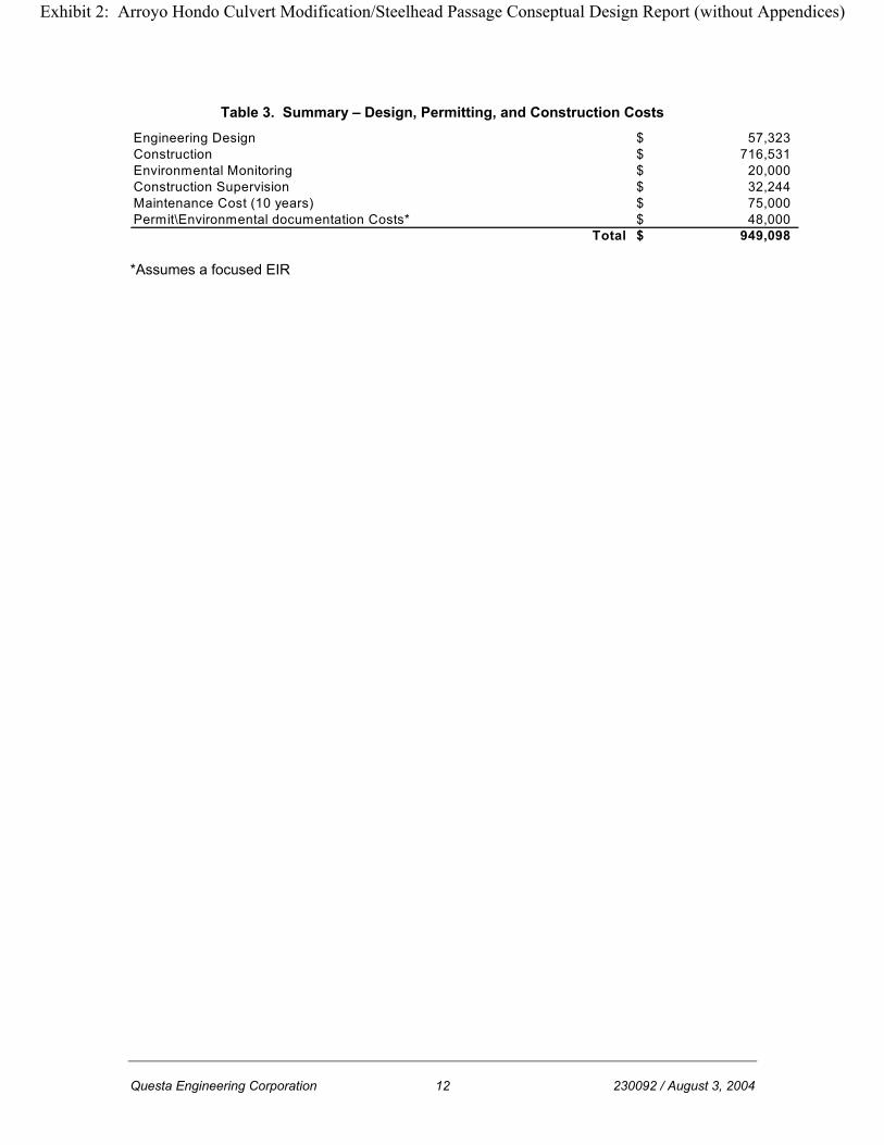
Table 3. Summary – Design, Permitting, and Construction Costs Engineering Design 57,323$ Construction 716,531$ Environmental Monitoring 20,000$ Construction Supervision 32,244$ Maintenance Cost (10 years) 75,000$ Permit\Environmental documentation Costs* 48,000$
Total 949,098$
*Assumes a focused EIR
Exhibit 2: Arroyo Hondo Culvert Modification/Steelhead Passage Conseptual Design Report (without Appendices)

Questa Engineering Corporation 13 230092 / August 3, 2004
6. WATERSHED CHARACTERISTICS
6.1 Climate and Topography
The project site is located in southern Santa Barbara County on the south-facing slopes of the Santa Ynez Mountains. The Santa Ynez Mountains run in an east-west direction and are bordered on the north by the Santa Ynez River valley and on the south by the Pacific Ocean. The area from the top of the mountain ridges to the coastline is referred to as the Gaviota Coast, which extends from Coal Oil Point at the edge of Isla Vista to Point Sal and is considered to be one of the California’s longest remaining stretches of undeveloped coastline. The Gaviota Coast marks the transition zone between the moist, cool climate of Northern California and the drier, warmer climate of Southern California. This coastline is generally characterized by a classic Mediterranean climate with mild temperatures throughout the year, with average coastal air temperatures of approximately 12 degrees Celsius (53 degrees Fahrenheit) in the winter and 19 degrees Celsius (66 degrees Fahrenheit) in the summer. Average yearly precipitation in the region is 412.7 mm (16.2 inches), with the majority of precipitation occurring between November and April. Most rainfall occurs as short and heavy rain showers driven by tropical air masses. Average monthly rainfall patterns in the region are presented in Table 4.
Table 4. Average Monthly Precipitation
Jan Feb Mar Apr May Jun Jul Aug Sep Oct Nov Dec Annual Millimeters 81.5 91.6 72.1 26.9 4 1 0.5 2.7 11.4 13.2 51.5 55.8 412.7
Inches 3.2 3.6 2.8 1.1 0.2 0 0 0.1 0.4 0.5 2 2.2 16.2 6.2 Watershed Characteristics
The project site is located within the Arroyo Hondo Creek watershed (Figure 1), a rural watershed running north to south and draining an area of approximately 2,800 acres. The creek is perennial and runs southward through the steep canyons of Los Padres National Forest to the Santa Barbara Channel of the Pacific Ocean. Just above the mouth of the creek, Arroyo Hondo is conveyed beneath Highway 101, the historic Highway 101 bridge, and the UPR trestle via a concrete arch culvert and a concrete flume. The Santa Barbara Land Trust Conservancy owns the lowermost portion of the watershed. Elevations in the Arroyo Creek watershed range from 817 meters (2,680 feet) above mean sea level (MSL) in the upper watershed to sea level where the creek empties into the Pacific Ocean. 6.2 Geology
The project site is located within the Transverse Ranges geomorphic province of California. The Transverse Ranges are a series of mountain ranges and valleys that run
Exhibit 2: Arroyo Hondo Culvert Modification/Steelhead Passage Conseptual Design Report (without Appendices)

Questa Engineering Corporation 14 230092 / August 3, 2004
east to west and are dominated by thick, tilted, and faulted sequences of sedimentary deposits. At the project site, bedrock is dominated by sedimentary rocks from the middle Miocene and Eocene periods. These include Monterey shale, Rincon shale, Vaqueros sandstone, siltstone, claystone, and mudstone. 6.3 Watershed Soils
Soil characteristics influence drainage patterns within a watershed. Soils in the Arroyo Hondo watershed were identified in the United States Department of Agriculture Soil Conservation Service Survey of Santa Barbara County, South Coastal Part. Several soil types have been classified within the watershed. Generally, these are Class D soils, which have very slow infiltration rates when thoroughly wetted and consist chiefly of clay soils with a high swelling potential, soils with a permanent high water table, soils with a clay-pan of clay layer at or near the surface, and shallow soils over nearly impervious material. These generally have a very slow rate of water transmission and high runoff potential. Soils in the upper watershed belong to the Maymen series. The Maymen series, found on steep slopes (50-100%), is derived from material weathered from sandstone, conglomerate, and shale bedrock. The rock outcrop-Maymen complex has exposed sandstone, shale, or conglomerate formations. This complex consists of about 70% rock outcrop and only 30% soil. Soils in the middle watershed are predominantly of the Lodo-Sespe complex and Gaviota sandy loams. The Lodo-Sespe complex, found on 50-75% slopes, is formed in material weathered from sandstone and shale bedrock. This soil is generally described as gravelly clay loam. Gaviota sandy loams (30-50%) are steep to very steep soils found as a band between the middle and lower watershed. This soil forms in material weathered from hard sandstone and is littered with hard sandstone, stones, and boulders. Three types of Ayar clays are found in the lower watershed (30-75% slopes). The difference between these three soil types is primarily distance to bedrock. The Ayar series is formed in material weathered from soft calcareous shale or mudstone. Also found in the lower watershed, Argixerolls and Xererts, are masses of soil material and rock fragments that have slid downslope during landslide movement. In the Arroyo Hondo Creek watershed, these soils are found on slopes ranging from 30-50%. Soils along the Arroyo Hondo Creek channel are classified as Agueda silty clay loam (2-9%). The Agueda series consists of well-drained soils formed in alluvium derived from calcarious, sedimentary formations.
Exhibit 2: Arroyo Hondo Culvert Modification/Steelhead Passage Conseptual Design Report (without Appendices)

Questa Engineering Corporation 15 230092 / August 3, 2004
7. HYDRAULIC AND HYDROLOGIC ANALYSIS
This section examines estimated peak discharge rates for the watershed, models and examines a range of existing flows through the project reach, describes the hydraulic structures through the project reach, and analyzes existing fish passage constraints. 7.1 Hydrology
Arroyo Hondo is not included in the Federal Emergency Management Agency flood insurance study for the unincorporated portions of Santa Barbara County (FEMA, 1979). Review of available documents regarding Arroyo Hondo Creek show several differing estimated peak 100-year flow rates, shown in Table 5 below.
Table 5. Design Hydrology Estimates
Drainage Area 100-Year Peak Flow Source Year
(sq. km) (acres) (cms) (cfs)
Santa Barbara County 2001 11.3 2,800 70.80 2,500
Caltrans 1948 13.6 3,360 100.50 3,550
Caltrans 2001 11.3 2,800 140.00 4,944
Currently, more detailed hydrologic modeling to determine peak flow rates through the watershed has not been performed, since it is not essential for fish passage hydraulic analysis. Instead, flows of much lower recurrence intervals were modeled to quantify flow conditions accessible for fish passage. For this preliminary analysis, a range of flows were modeled, 0.03 cms – 14.16 cms (1 – 500 cfs), at varying intervals (Table 6).
Table 6. Discharge Table - Cubic Meters per Sec (cms) vs Cubic Feet per Sec (cfs)
Discharge Discharge Discharge (cms) (cfs) (cms) (cfs) (cms) (cfs) 0.03 1 0.57 20 4.25 150 0.06 2 0.85 30 5.66 200 0.08 3 1.13 40 7.08 250 0.11 4 1.42 50 8.50 300 0.14 5 1.70 60 9.91 350 0.17 6 1.98 70 11.33 400 0.20 7 2.27 80 12.74 450 0.23 8 2.55 90 14.16 500 0.25 9 2.83 100 0.28 10
Exhibit 2: Arroyo Hondo Culvert Modification/Steelhead Passage Conseptual Design Report (without Appendices)

Questa Engineering Corporation 16 230092 / August 3, 2004
Current gage data. A flow gage has been installed at the mouth of the Highway 101 culvert. This gage is operated and monitored by the University of California, Santa Barbara. The gage continuously record flows in the arroyo but is not high accurate below flows less than 4 cfs or so. A typical winter hydrograph is shown in Figure 9.
7.1.1 Hydraulic Model
Hydraulic analysis consists of modeling the flow regime through the channel reach as characterized by surveyed cross-sections. The field data were imported into HEC-RAS (Hydrologic Engineering Center River Analysis System version 3.1, 2002) hydraulic modeling software developed by the US Army Corps of Engineers. The hydraulic model predicts flow velocity, water surface elevations, and water depths, among other hydraulic parameters. The flow regime used to model fish passage did not include flow numbers high enough to fill the existing culvert; thus, the project reach could be modeled as open channel flow throughout its entire length. This allowed cross-sections to be inserted within the culvert reach to better characterize flow conditions within the culvert, i.e. fish passage flow conditions.
7.1.2 Methods
• 1D Hydraulic Model. HEC-RAS is a one-dimensional hydraulic model capable of calculating water surface profiles for steady, gradually varied flow. The basic computational procedure is based on the solution of the one-dimensional energy equation. Energy losses are evaluated by friction (Manning’s n coefficient) and contraction/expansion (coefficient multiplied by the change in velocity head). The model is therefore capable of evaluating backwater effects caused by channel constrictions such as undersized culverts. This hydraulic analysis was performed with the assumption that flow in Arroyo Hondo Creek is uniform, steady, open-channel flow. A mixed regime steady flow analysis was computed, where flow can be either sub- or super-critical.
• Cross-section Geometry. A total of 16 surveyed cross-sections were used for the HEC-RAS analysis. Fifteen cross-sections, 5 meters (16 ft) apart, were inserted within the culvert length, with the spacing determined by fish baffle parameters for the length of the culvert.
• Roughness. Roughness coefficients were assigned to left overbank, channel, and right overbank sections of each cross-section. Different roughness coefficient values reflect different surface “roughness” qualities. Table 7 shows Manning’s n values used for the hydraulic model. Where the reach was channelized (concrete bed), roughness coefficients were adjusted accordingly.
Exhibit 2: Arroyo Hondo Culvert Modification/Steelhead Passage Conseptual Design Report (without Appendices)

Questa Engineering Corporation 17 230092 / August 3, 2004
Table 7. Manning’s n Roughness Coefficients
Reach Left Bank n Channel n Right Bank n
Upstream of culvert
Riparian vegetation: grasses and shrubs .045
Natural with earthen bottom; sand-gravel-
cobble; pool-riffle complex
0.035 Riparian vegetation: grasses and shrubs 0.045
Culvert - - - - - - Concrete 0.010 - - - - - -
Flume - - - - - - Concrete 0.010 - - - - - -
Lagoon Sand; Ruderal vegetation 0.025 Sand 0.025 Sand 0.025
• Hydraulic Structures. The Arroyo Hondo Highway 101 culvert was built in
1949. It is a 93.6-m (307-ft) long concrete arch culvert. The culvert has a 4.9-m (16-ft) span and a 5.2-m (17-ft) height along its centerline. Downstream and upstream culvert invert elevations were taken from the topographic survey of the site. The culvert has a slope of 0.01. Cross-sections developed for the hydraulic model to represent the cross-section geometry of the culvert bottom were taken from California Department of Transportation (Caltrans) Standard D95 for concrete arch culverts. Culvert cross-section dimensions follow the Caltrans standard dimensions for a 4.9-m (16-ft) span concrete arch culvert.
Immediately downstream of the culvert is a concrete flume (box channel) that forms a spillway for outflow from the culvert. The concrete flume is 50 meters (164 ft) long and 4.8 m (15.8 ft) wide. Flume walls are 3 meters (9.8 ft) high. For the last 6 m (20 ft), the flume widens to reach a width of 8.3 m (27 ft) at its downstream outlet, and flume walls decrease in height to 1.6 m (5 ft). All transitions in culvert geometry were incorporated into the hydraulic model via cross-section geometries input along the length of the culvert.
• Steady Flow Analysis. The steady flow analysis requires the input of user-defined profiles specifying peak flow data and model boundary conditions.
In a modeled flow regime, boundary conditions are necessary at the upstream and downstream ends of the river system. This analysis used a “Normal Depth” boundary condition at the upstream boundary, requiring an energy slope to be used in calculating normal depth (Manning’s equation) at each cross-section for each profile. Since the energy slope was unknown, the average slope of the channel bottom, 0.01, was used. At the downstream boundary, a known water surface elevation was used as the boundary condition. The tidal datum Mean Higher High Water (MHHW) from the Santa Barbara, California NOAA station (converted to vertical control NAVD 88 to match elevations from the Arroyo Hondo survey) was used as the downstream boundary. The MHHW for the Santa Barbara station was 1.672 m (NAVD88). A sensitivity analysis showed that a variation in the MHHW of +/- 2 feet did not affect hydraulic model results.
Exhibit 2: Arroyo Hondo Culvert Modification/Steelhead Passage Conseptual Design Report (without Appendices)

Questa Engineering Corporation 18 230092 / August 3, 2004
7.1.3 Existing Condition Hydraulic Modeling Results
Hydraulic model results for existing conditions are shown in Table 8. Because the objective is to improve fish passage through the culvert, flow velocities and depths for only the culvert cross-sections were averaged to provide a look at existing fish passage conditions. Figures 10 through 13 show velocity-discharge and depth-discharge curves for the culvert. Fish passage criteria are discussed further in Section 4 - Proposed Project, but hydraulic model results show that due to fish passage velocity and depth constraints, the culvert under existing conditions is passable during flows ranging from to 0.14 cms to 1.13 cms (5 to 40 cfs).
Table 8. Existing Condition Hydraulic Model Results
Depth Velocity Depth Velocity(m3) (cfs) (ft) (ft/sec) (m) (m/sec)0.03 1 0.18 1.62 0.07 0.350.06 2 0.22 2.2 0.09 0.40.08 3 0.24 2.2 0.1 0.450.11 4 0.33 2.4 0.12 0.520.14 5 0.34 2.7 0.14 0.510.17 6 0.37 2.87 0.14 0.590.2 7 0.41 2.91 0.16 0.59
0.23 8 0.43 3.07 0.17 0.60.25 9 0.44 3.2 0.18 0.620.28 10 0.48 3.19 0.19 0.650.57 20 0.67 3.9 0.26 0.810.85 30 0.83 4.35 0.31 0.931.13 40 0.96 4.71 0.35 1.031.42 50 1.08 5.02 0.39 1.11.7 60 1.19 5.27 0.41 1.2
1.98 70 1.28 5.52 0.44 1.262.27 80 1.37 5.82 0.47 1.322.55 90 1.46 6.01 0.5 1.362.83 100 1.54 6.2 0.52 1.424.25 150 1.95 6.82 0.62 1.645.66 200 2.26 7.41 0.69 1.827.08 250 2.53 8 0.76 1.988.5 300 2.78 8.5 0.82 2.12
9.91 350 3.02 8.94 0.88 2.2211.33 400 3.25 9.35 0.94 2.2812.74 450 3.47 9.72 0.98 2.3714.16 500 3.68 10.07 1.02 2.46
Flows Existing Conditions
Note: data is for cross section 1+57
Exhibit 2: Arroyo Hondo Culvert Modification/Steelhead Passage Conseptual Design Report (without Appendices)

Questa Engineering Corporation 19 230092 / August 3, 2004
Figure 10. Average Culvert Velocity (mps)
0.00
1.00
2.00
3.00
4.00
5.00
0.00 2.00 4.00 6.00 8.00 10.00 12.00 14.00 16.00
Discharge (cms)
Velo
city
(mps
)
Figure 11. Average Culvert Velocity (fps)
0.001.002.003.004.005.006.007.008.009.00
10.0011.0012.0013.0014.0015.00
0 100 200 300 400 500 600
Discharge (cfs)
Velo
city
(fps
)
Exhibit 2: Arroyo Hondo Culvert Modification/Steelhead Passage Conseptual Design Report (without Appendices)

Questa Engineering Corporation 20 230092 / August 3, 2004
Figure 12. Average Culvert Depth (m)
0.00
0.10
0.20
0.30
0.40
0.50
0.60
0.70
0.80
0.90
1.00
0.00 2.00 4.00 6.00 8.00 10.00 12.00 14.00 16.00
Discharge (cms)
Dep
th (m
)
Figure 13. Average Culvert Depth (ft)
0.00
1.00
2.00
3.00
0 100 200 300 400 500 600
Discharge (cfs)
Dep
th (f
t)
Exhibit 2: Arroyo Hondo Culvert Modification/Steelhead Passage Conseptual Design Report (without Appendices)

Questa Engineering Corporation 21 230092 / August 3, 2004
7.2 Baffled Hydraulic Modeling Analysis
In order to determine the impacts of the changes to the culvert, several hydraulic models detailing future conditions in and around the culvert were examined. The first was used to model the proposed baffle structure within the culvert. This model treats the culvert as an open channel and is concerned with the performance of the baffles in flows less than 500 cfs. The second model treated the culvert as a culvert and looked at the changes in flow dynamics upstream and downstream. The following is a summary of the future conditions hydraulics.
7.2.1 Baffle Design and Performance
The proposed baffles need to accomplish two goals:
1. To reduce flow velocity moving through the culvert.
2. To increase the depth of flow during low-flow levels so that fish can pass through without scraping or otherwise injuring themselves.
Fish passage criteria we discussed in depth previously. To summarize, fish can migrate successfully through the culvert when:
• Velocity is 3 ft/s or less
• Minimum depth is 0.5 feet.
Table 9 summarizes the effects of baffles in the culvert. Figures 14 through 17 also show the impact of the baffle structure. Under existing conditions, the culvert is generally only passable for flows between 7 and 10 cfs. At these flows, depths as well as velocity are nearly at the limits. With a baffles system, the passable flow range is extended from 1 to 100 cfs, though optimal conditions exist below 50 cfs. This is substantial improvement; fish migration can take place through most of the receding limb of a storm runoff hydrograph. It should be noted that Table 9 represents velocities and depths in between each baffle structure. Velocities and depths passing over the baffle structure are higher and shallower, respectively. However, these only occur for short distances and are within the burst speed of the migrating fish.
Exhibit 2: Arroyo Hondo Culvert Modification/Steelhead Passage Conseptual Design Report (without Appendices)

Questa Engineering Corporation 22 230092 / August 3, 2004
Table 9. Summary of Baffled vs. Existing Conditions
Depth Velocity Depth Velocity Depth Velocity Depth Velocity(m3) (cfs) (ft) (ft/sec) (m) (m/sec) (ft) (ft/sec) (m) (m/sec)0.03 1.06 0.18 1.62 0.07 0.35 1.17 0.14 0.36 0.040.06 2.12 0.22 2.2 0.09 0.4 1.27 0.24 0.39 0.070.08 2.83 0.24 2.2 0.1 0.45 1.33 0.31 0.41 0.090.11 3.89 0.33 2.4 0.12 0.52 1.41 0.39 0.43 0.120.14 4.94 0.34 2.7 0.14 0.51 1.48 0.47 0.45 0.140.17 6 0.37 2.87 0.14 0.59 1.54 0.55 0.47 0.170.2 7.06 0.41 2.91 0.16 0.59 1.59 0.62 0.48 0.190.23 8.12 0.43 3.07 0.17 0.6 1.64 0.68 0.5 0.210.25 8.83 0.44 3.2 0.18 0.62 1.67 0.73 0.51 0.220.28 9.89 0.48 3.19 0.19 0.65 1.71 0.79 0.52 0.240.57 20.13 0.67 3.9 0.26 0.81 2.05 1.24 0.62 0.380.85 30.02 0.83 4.35 0.31 0.93 2.21 1.6 0.67 0.491.13 39.91 0.96 4.71 0.35 1.03 2.35 1.89 0.72 0.581.42 50.15 1.08 5.02 0.39 1.1 2.48 2.17 0.76 0.661.7 60.04 1.19 5.27 0.41 1.2 2.6 2.4 0.79 0.731.98 69.92 1.28 5.52 0.44 1.26 2.7 2.62 0.82 0.82.27 80.16 1.37 5.82 0.47 1.32 2.81 2.82 0.86 0.862.55 90.05 1.46 6.01 0.5 1.36 2.91 3 0.89 0.922.83 99.94 1.54 6.2 0.52 1.42 3 3.17 0.91 0.974.25 150.09 1.95 6.82 0.62 1.64 3.46 3.87 1.05 1.185.66 199.88 2.26 7.41 0.69 1.82 3.87 4.4 1.18 1.347.08 250.03 2.53 8 0.76 1.98 4.26 4.84 1.3 1.478.5 300.18 2.78 8.5 0.82 2.12 4.64 5.21 1.41 1.599.91 349.97 3.02 8.94 0.88 2.22 4.97 5.55 1.52 1.69
11.33 400.12 3.25 9.35 0.94 2.28 5.3 5.86 1.61 1.7912.74 449.91 3.47 9.72 0.98 2.37 5.61 6.14 1.71 1.8714.16 500.06 3.68 10.07 1.02 2.46 5.91 6.41 1.8 1.95
Existing Conditions Future ConditionsFlows
Note: data is for cross section 1+57 and 1+57.5. Baffled conditions represent depths and velocities between baffles The table results are shown graphically in Figures 14 through 17.
Exhibit 2: Arroyo Hondo Culvert Modification/Steelhead Passage Conseptual Design Report (without Appendices)

Questa Engineering Corporation 23 230092 / August 3, 2004
Figure 14. Culvert Flow Velocity (fps)
0 2 4 6 8
10 12
0 100 200 300 400 500 600 Flow (cfs)
Velo
city
(ft/s
)
Existing Conditions Baffled Conditions
Figure 15. Culvert Flow Velocity (mps)
0 0.5
1 1.5
2 2.5
3
0 2 4 6 8 10 12 14 16 Flow (cubic meters/sec)
Velo
city
(m/s
)
Existing Conditions Baffled Conditions
Exhibit 2: Arroyo Hondo Culvert Modification/Steelhead Passage Conseptual Design Report (without Appendices)

Questa Engineering Corporation 24 230092 / August 3, 2004
Figure 16. Culvert Flow Depth (ft)
0 1 2 3 4 5 6 7
0 100 200 300 400 500 600
Flow (cfs)
Dep
th (f
t)
Existing Conditions Baffled Conditions
Figure 17. Culvert Flow Depth (m)
0
0.5
1
1.5
2
0 2 4 6 8 10 12 14 16 Flow (cubic meters/sec)
Dep
th (m
)
Existing Conditions Baffled Conditions
7.2.3 Baffled Culvert Under Design Hydrology Conditions
An important consideration is the effect of the baffles structure on very high or design stream flows. As previously discussed, hydrological flow numbers differ. These flows are shown in Table 10.
Exhibit 2: Arroyo Hondo Culvert Modification/Steelhead Passage Conseptual Design Report (without Appendices)

Questa Engineering Corporation 25 230092 / August 3, 2004
Table 10. Design Hydrology
Drainage Area 100-Year Peak Flow Source Year
(sq. km) (acres) (cms) (cfs)
Santa Barbara County 2001 11.3 2800 70.80 2,500
Caltrans 1948 13.6 3360 100.50 3,550
Caltrans 2001 11.3 2800 140.00 4,944
The culvert was evaluated using a separate hydraulic model for both existing and baffled conditions. This model utilized bridge modeling techniques to determine the water surface elevations upstream and downstream of the culvert. The hydraulic model indicated that the entrance conditions (shape, etc.) of the culvert generally control water surface elevation at the culvert entrance and in the upstream channel and floodplain. This condition is generally known as inlet control. It should be stated that under no circumstances is Highway 101 under any threat of being overtopped or impacted in any major way. The main issue is the amount water backup at the entrance to the culvert and its potential impact to existing facilities, such as the hacienda in the valley. Accurate floodplain modeling of this area is difficult due to lack of detailed topographic information on the associated floodplain so far upstream of the culvert. The hacienda has a first floor elevation of 11.28 m (37 feet). Table 11 shows the impact of placing baffles in the culvert. The baffled conditions were modeled by amending the culvert cross section and increasing the culvert Mannings n value from 0.01 to 0.016 to compensate for the additional hydraulic roughness in the culvert.
Table 11. Existing and Proposed Water Surface Elevations Under Design Flows
Water Surface Water Surface(cfs) (cu. m) Elevation (m) Velocity (m/s) Elevation (m) Velocity (m/s) Change (m) Change (ft)2,498 70.8 6.96 4.24 7.53 4.03 0.57 1.873,546 100.5 8.17 4.45 8.86 4.18 0.69 2.264,940 140 9.94 4.48 11.42 3.84 1.48 4.85
Downstream of culvert
2,498 70.8 6.4 3.81 6.14 4.61 -0.26 -0.853,546 100.5 7.24 4.43 6.96 5.19 -0.28 -0.924,940 140 8.24 5.08 7.93 5.82 -0.31 -1.02
Existing Conditions Future ConditionsFlows
The additional baffles increase water surface elevations at the culvert by 0.57 m to 1.48 m (1.87 feet to 4.85 feet) depending on the flow scenario. The modeling shows that under existing conditions, the Santa Barbara and original Caltrans flows come up to but do not go above the top of the culvert. However, the highest 2001 Caltrans flows are approximately 1 m (3.3 feet) above the top of the culvert. When this happens, the culvert
Exhibit 2: Arroyo Hondo Culvert Modification/Steelhead Passage Conseptual Design Report (without Appendices)

Questa Engineering Corporation 26 230092 / August 3, 2004
begins experience pressure flow and becomes very sensitive to alterations in cross section geometry and hydraulic roughness. In terms of the hacienda, our best estimate under existing conditions is that the structure is below flood levels; no structure flooding is known to have occurred historically. However, water is calculated to above floor level under 2001 Caltrans levels (4,940 cfs). Under proposed or baffled conditions, the hacienda is out of the floodplain for flows below 4,200 cfs. Flows above this mark will likely cause flooding of the building. It should be noted that flows in this magnitude are extremely rare. While it is difficult to precisely estimate the risk of flooding to the hacienda, placing baffles in the culvert will increase the flood risk for the building under extremely high and rare flows.
Exhibit 2: Arroyo Hondo Culvert Modification/Steelhead Passage Conseptual Design Report (without Appendices)

Questa Engineering Corporation 27 230092 / August 3, 2004
8. CONCLUSION
The development of the proposed project has involved numerous methodical steps, including the assessment of the existing passage conditions, developing alternatives for separate project components, and analysis of the hydrologic and hydraulic conditions. The proposed project integrates the needs of the fish passage, pedestrian access, and habitat enhancement in the lower portion of the Arroyo Hondo watershed. The primary goal of the project is to improve fish passage through the existing culvert. The baffle design was developed by examining several culvert modification alternatives, including culvert bottom removal. As proposed, the baffle design increases flow depth, reduces overall flow velocity, and provides resting zones within the culvert. The baffle structure will increase the range of flows in which the fish can successfully move through the culvert from 7 to 10 cfs under existing conditions, to 1 to 50 cfs under baffle design conditions. This will allow for greater upstream migration during a single flow event. While it may not immediately allow more fish to move through the culvert, it is likely to increase the number of fish reaching the upper spawning areas of the arroyo. These areas retain flow year-round; salmon fry have a better chance of surviving in this section of the arroyo and growing to a size that better enables them to migrate downstream and into the Pacific Ocean. Improving fish passage has a cost. The baffles decrease the effective culvert cross sectional area and increase the turbulence within the culvert. These in turn change the hydraulic performance, raising water surface elevations at the mouth and increasing the amount of floodplain flooding immediately upstream of the culvert. Under extreme flow scenarios, these hydraulic changes increase the risk of flooding to nearby structures. The risk is small, however, and the beneficial impact of the project likely outweighs the slight risk to the structure. The proposed project will also provide better access to the beach and to the culvert for maintenance. The new walkway will allow access during low and moderate flows, increasing safety as well as frequency of culvert inspections and maintenance. Habitat enhancements are a key component of the project. When the culvert was constructed in 1949, large sections of the creek and lagoon were destroyed. These sections were key components of both the upstream and downstream migration of the steelhead. Resting pools were lost and a transitional brackish lagoon was altered. Removing portions of the concrete box will relocate the current scour pool/lagoon further away from the influences of the tide and littoral sand transport. This will make the lagoon feature more stable and provide for habitat even during extended periods of drought. Reducing the scour action of the culvert outlet will directly benefit other endangered species that reside in the lagoon, such as the tidewater goby and the red-legged frog. The enhancements planned for the upstream section of the project will replace pools lost when the channel was straightened for culvert construction. They will also provide a resting pool for migrating fish, as well as increased fresh water aquatic habitat.
Exhibit 2: Arroyo Hondo Culvert Modification/Steelhead Passage Conseptual Design Report (without Appendices)

Questa Engineering Corporation 28 230092 / August 3, 2004
8.1 Next Steps
8.1.1 Permitting and Approval
To progress with project implementation, several courses of action need to be taken in terms of permitting and approval processes. The following briefly explains necessary approvals and permits:
• U. S. Army Corps of Engineers Section 404 Permit. This permit is required when any fill is discharged into jurisdictional water of the U.S. Because of the endangered species issues concerning frogs, fish, and gobies, consultation with both the NMFS and the U.S. Fish and Wildlife Service will be required. No permit fee is required.
• California Department of Fish and Game (CDFG) Streambed Alteration Agreement. In order to disturb bed and banks of a stream, approval from the CDFG is required. Their review will include engineering evaluation and will require CEQA evaluation. A permit fee is required.
• Regional Water Quality Control Board Certification. Construction involving active streams or disturbing more than 1 acre of area must attain water quality certification or a waiver from compliance. A project description, as well as proposed water quality control measures for both construction and long-term, will be required. A permit fee is required.
• Coastal Development Permit. This will be required because the project is within the coastal zone. This permit with the California Coastal Commission is administered by Santa Barbara County and requires CEQA evaluation. A permit fee is required.
• California Environmental Quality Act (CEQA) Evaluation. As part of the overall permitting effort, the project’s temporary and long-term environmental impacts need to be investigated. Restoration projects like this typically involve an initial study, which identifies impacts and proposes feasible mitigations. We expect this project to receive a mitigated negative declaration and not necessitate a full environmental impact report (EIR); however that determination will up to the County or other lead agency. Evaluation fees will be required.
• Caltrans Encroachment Permit. Caltrans has easement and maintenance rights to the culvert and the adjacent roadway embankment. Modifying the culvert requires an encroachment permit, which will be review by numerous departments within the Caltrans prior to approval. A permit fee is required.
• Union Pacific Railroad. Construction work will be taking place in and around the existing railroad easement and structure. Any work within this easement or potentially impacting railroad facilities must be approved by UPR. A project review fee is required.
Exhibit 2: Arroyo Hondo Culvert Modification/Steelhead Passage Conseptual Design Report (without Appendices)

Questa Engineering Corporation 29 230092 / August 3, 2004
8.1.1 Funding
There are numerous state and federal sources that may be solicited for funding the design, permitting, and construction of the project. An application for funding has already been submitted to the CDFG. Final review and funding decisions will be completed by December of 2004.
Exhibit 2: Arroyo Hondo Culvert Modification/Steelhead Passage Conseptual Design Report (without Appendices)

Appendix A Hydraulic Modeling Output Summaries
Exhibit 2: Arroyo Hondo Culvert Modification/Steelhead Passage Conseptual Design Report (without Appendices)

Appendix B Geotechnical Reconnaissance
Exhibit 2: Arroyo Hondo Culvert Modification/Steelhead Passage Conseptual Design Report (without Appendices)

Appendix C Draft Permit Forms
Exhibit 2: Arroyo Hondo Culvert Modification/Steelhead Passage Conseptual Design Report (without Appendices)

Appendix D Draft CEQA Checklist
Exhibit 2: Arroyo Hondo Culvert Modification/Steelhead Passage Conseptual Design Report (without Appendices)

Exhibit 2: Arroyo Hondo Culvert Modification/Steelhead Passage Conseptual Design Report (without Appendices)

Exhibit 2: Arroyo Hondo Culvert Modification/Steelhead Passage Conseptual Design Report (without Appendices)

Exhibit 2: Arroyo Hondo Culvert Modification/Steelhead Passage Conseptual Design Report (without Appendices)

Exhibit 2: Arroyo Hondo Culvert Modification/Steelhead Passage Conseptual Design Report (without Appendices)
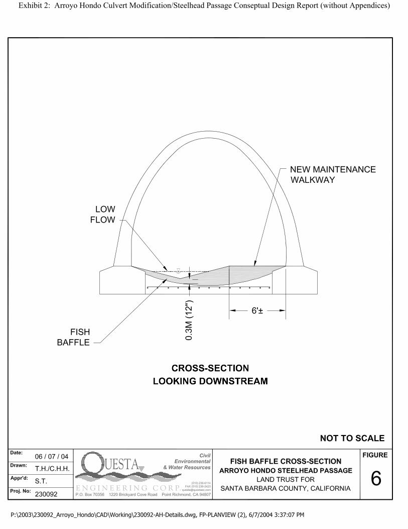
Exhibit 2: Arroyo Hondo Culvert Modification/Steelhead Passage Conseptual Design Report (without Appendices)

Exhibit 2: Arroyo Hondo Culvert Modification/Steelhead Passage Conseptual Design Report (without Appendices)
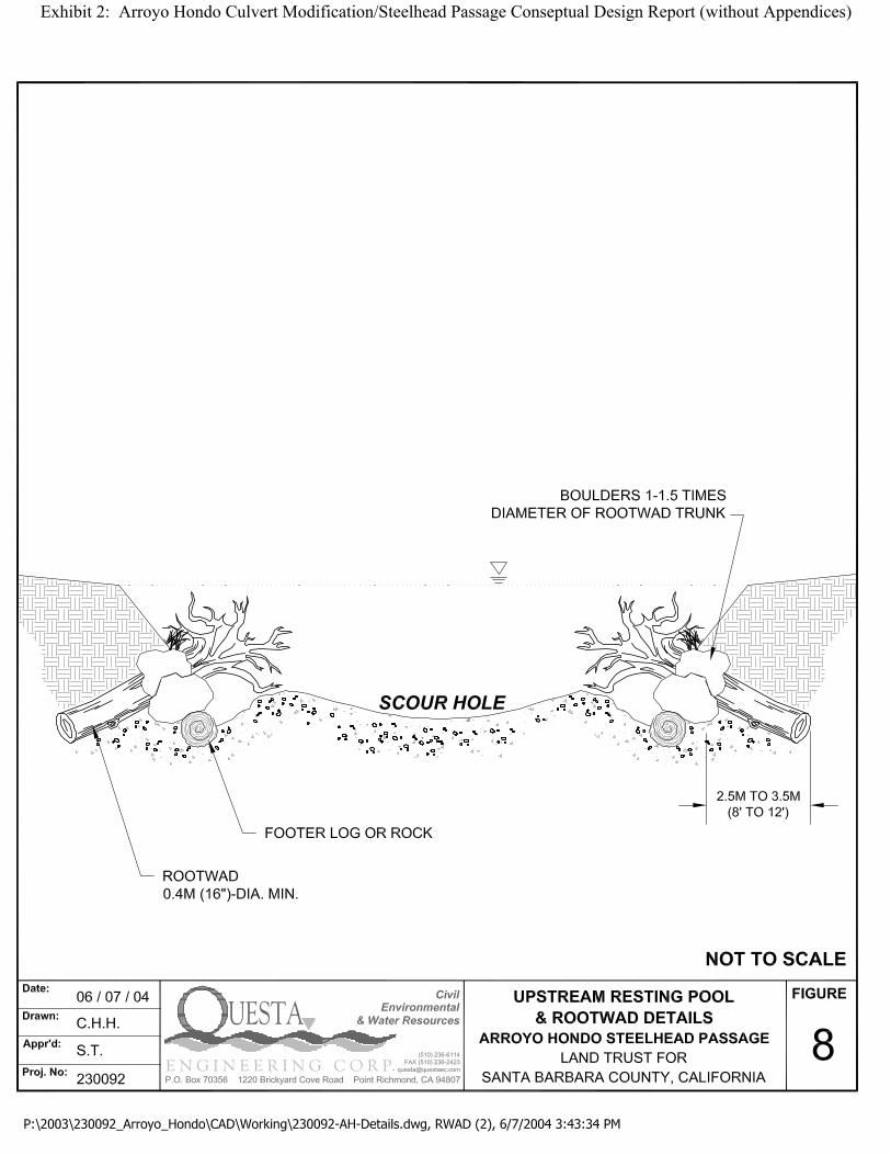
Exhibit 2: Arroyo Hondo Culvert Modification/Steelhead Passage Conseptual Design Report (without Appendices)

Exhibit 2: Arroyo Hondo Culvert Modification/Steelhead Passage Conseptual Design Report (without Appendices)