Embed Size (px)
Citation preview
ARLINGTON LAND USE (ZONING) BYLAW
AND
FLOOD HAZARD AREAS REGULATIONS
as amended by the TOWN OF ARLINGTON
June 12, 2006
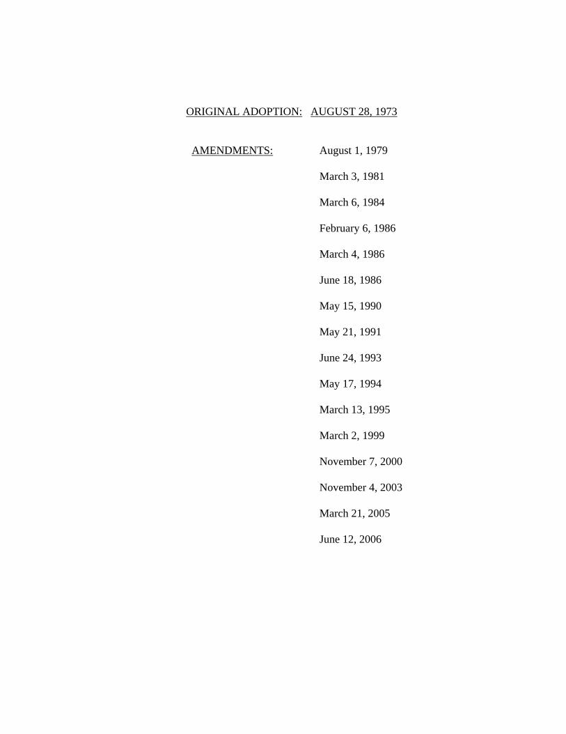
ORIGINAL ADOPTION: AUGUST 28, 1973 AMENDMENTS: August 1, 1979 March 3, 1981 March 6, 1984 February 6, 1986 March 4, 1986 June 18, 1986 May 15, 1990 May 21, 1991 June 24, 1993 May 17, 1994 March 13, 1995 March 2, 1999 November 7, 2000 November 4, 2003 March 21, 2005 June 12, 2006
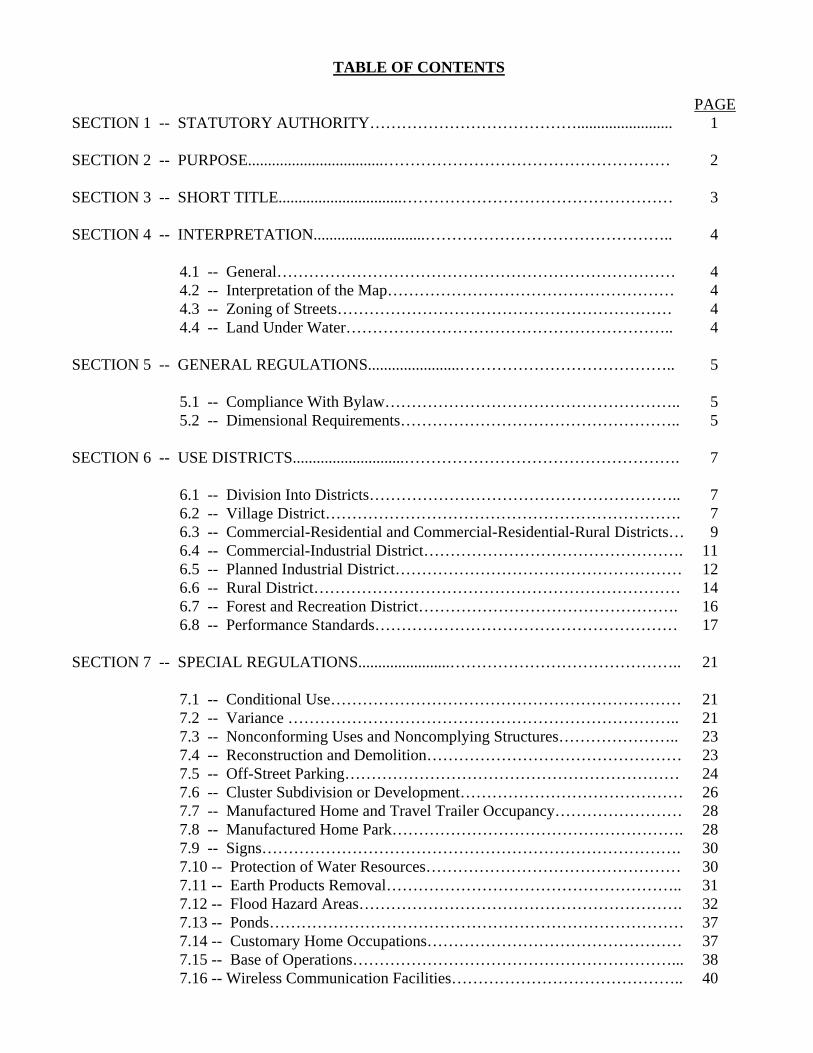
TABLE OF CONTENTS PAGE SECTION 1 -- STATUTORY AUTHORITY…………………………………........................ 1 SECTION 2 -- PURPOSE..................................……………………………………………… 2 SECTION 3 -- SHORT TITLE...............................…………………………………………… 3 SECTION 4 -- INTERPRETATION............................……………………………………….. 4 4.1 -- General………………………………………………………………… 4 4.2 -- Interpretation of the Map……………………………………………… 4 4.3 -- Zoning of Streets……………………………………………………… 4 4.4 -- Land Under Water…………………………………………………….. 4 SECTION 5 -- GENERAL REGULATIONS.......................………………………………….. 5 5.1 -- Compliance With Bylaw……………………………………………….. 5 5.2 -- Dimensional Requirements…………………………………………….. 5 SECTION 6 -- USE DISTRICTS............................……………………………………………. 7 6.1 -- Division Into Districts………………………………………………….. 7 6.2 -- Village District…………………………………………………………. 7 6.3 -- Commercial-Residential and Commercial-Residential-Rural Districts… 9 6.4 -- Commercial-Industrial District…………………………………………. 11 6.5 -- Planned Industrial District……………………………………………… 12 6.6 -- Rural District…………………………………………………………… 14 6.7 -- Forest and Recreation District…………………………………………. 16 6.8 -- Performance Standards………………………………………………… 17 SECTION 7 -- SPECIAL REGULATIONS.......................…………………………………….. 21 7.1 -- Conditional Use………………………………………………………… 21 7.2 -- Variance ……………………………………………………………….. 21 7.3 -- Nonconforming Uses and Noncomplying Structures………………….. 23 7.4 -- Reconstruction and Demolition………………………………………… 23 7.5 -- Off-Street Parking……………………………………………………… 24 7.6 -- Cluster Subdivision or Development…………………………………… 26 7.7 -- Manufactured Home and Travel Trailer Occupancy…………………… 28 7.8 -- Manufactured Home Park………………………………………………. 28 7.9 -- Signs……………………………………………………………………. 30 7.10 -- Protection of Water Resources………………………………………… 30 7.11 -- Earth Products Removal……………………………………………….. 31 7.12 -- Flood Hazard Areas……………………………………………………. 32 7.13 -- Ponds…………………………………………………………………… 37 7.14 -- Customary Home Occupations………………………………………… 37 7.15 -- Base of Operations……………………………………………………... 38 7.16 -- Wireless Communication Facilities…………………………………….. 40
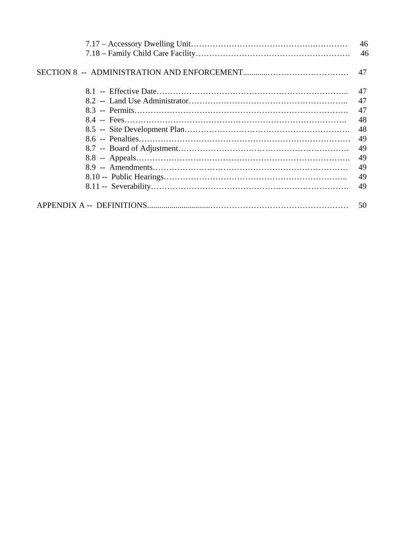
7.17 – Accessory Dwelling Unit……………………………………….………… 46 7.18 – Family Child Care Facility………………………………………………… 46 SECTION 8 -- ADMINISTRATION AND ENFORCEMENT............………………………… 47 8.1 -- Effective Date…………………………………………………………….. 47 8.2 -- Land Use Administrator………………………………………………….. 47 8.3 -- Permits……………………………………………………………………. 47 8.4 -- Fees………………………………………………………………………. 48 8.5 -- Site Development Plan……………………………………………………. 48 8.6 -- Penalties…………………………………………………………………… 49 8.7 -- Board of Adjustment……………………………………………………… 49 8.8 -- Appeals……………………………………………………………………. 49 8.9 -- Amendments……………………………………………………………… 49 8.10 -- Public Hearings………………………………………………………….. 49 8.11 -- Severability………………………………………………………………. 49 APPENDIX A -- DEFINITIONS...............................…………………………………………… 50
1
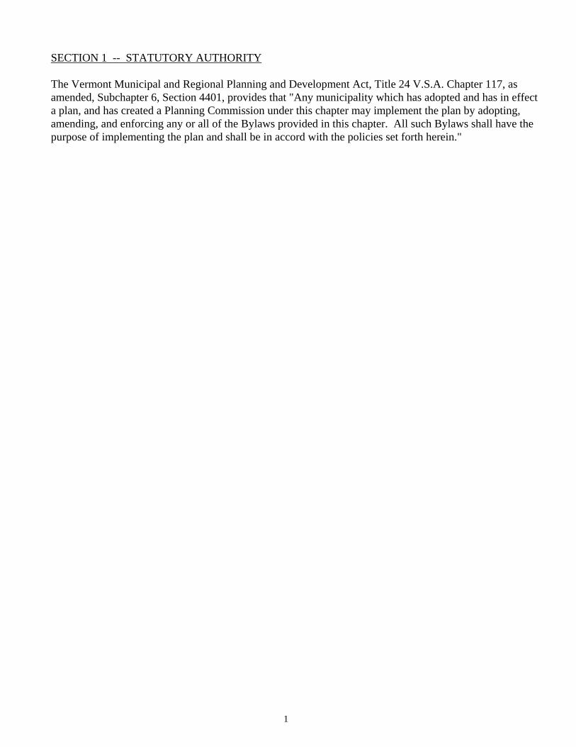
SECTION 1 -- STATUTORY AUTHORITY The Vermont Municipal and Regional Planning and Development Act, Title 24 V.S.A. Chapter 117, as amended, Subchapter 6, Section 4401, provides that "Any municipality which has adopted and has in effect a plan, and has created a Planning Commission under this chapter may implement the plan by adopting, amending, and enforcing any or all of the Bylaws provided in this chapter. All such Bylaws shall have the purpose of implementing the plan and shall be in accord with the policies set forth herein."
SECTION 2 -- PURPOSE This Bylaw is designed to protect and promote the public health, safety, and welfare of the people of the Town. It is intended to guide the future development of the Town in accordance with the Town Plan and to produce population densities that will bring about the most beneficial and convenient relationships among the residential, industrial, commercial, forest and recreational, and agricultural areas within the Town. This Bylaw is designed to maintain the character and economic stability of each part of the Town and to encourage orderly and beneficial development. It is designed to protect and conserve the value of land and buildings throughout the Town appropriate to the several districts established by this Bylaw. This Bylaw aims to bring about the most beneficial relationship between the uses of land and buildings and the circulation of traffic throughout the Town. It aims to provide a guide for public policy and action in the efficient provision of public facilities and services and for private enterprise in building development, investment, and other economic activity relating to the use of land and buildings throughout the Town.

3
SECTION 3 -- SHORT TITLE This Bylaw shall be known and may be cited as the ARLINGTON LAND USE (ZONING) BYLAW.
SECTION 4 -- INTERPRETATION 4.1 GENERAL In interpreting and applying the provisions of this Bylaw they shall be held to be the minimum
requirement adopted for the promotion of the public health, safety, comfort, convenience, and general welfare, and more particularly for the purposes set forth in Section 2. Except as specifically provided herein this Bylaw does not repeal, abrogate, annul, or in any way impair or interfere with any existing use of land or provision of law, or any rule or regulation previously adopted, or any permit, license, certificate, or other authorization previously issued, granted, or approved pursuant to law and not in conflict with the provisions hereof relating to the use of buildings or land, or to the erection, construction, establishment, moving, structural alteration of any building or improvement, nor does this Bylaw interfere with or abrogate or annul any easement, covenant, or other agreement between parties, provided, however, that wherever any provision of this ordinance or Bylaw imposes greater restrictions on the erection, construction, establishment, moving, structural alteration, or enlargement of any building or on the use of land in any district established by this Bylaw than are imposed by such existing provisions of law or ordinance or by such rules, regulations, permits, licenses, certificates, or other authorizations or by such easements, covenants, or agreements, then the provisions of this Bylaw shall control.
4.2 INTERPRETATION OF THE MAP The boundaries of the zoning districts described herein are shown on the Zoning Map of the Town
and amendments thereto. The map and any amendments are hereby declared to be part of this Bylaw. Any uncertainty as to the location of a district boundary line on the Zoning Map shall be resolved by the Land Use Administrator with appeals of any such decisions made to the Board of Adjustment.
4.3 ZONING OF STREETS Zoning districts shall include the beds of streets lying within them. Where opposite sides of a street
lie in different districts, the boundary shall be deemed the center of the right-of-way. 4.4 LAND UNDER WATER Zoning districts shall include any land under rivers, streams, lakes, or ponds lying within them.
Where opposite sides of a river or stream lie in different districts, the boundary shall be the thread of the river or stream. Where opposite sides of a lake, pond, swamp, or water body lie in different districts, the boundary shall be deemed to be the center thereof.
5
SECTION 5 -- GENERAL REGULATIONS 5.1 COMPLIANCE WITH BYLAW Except as otherwise provided in this Bylaw: 1. No building shall be erected and no existing building shall be moved, structurally altered,
added to or enlarged, nor shall any land be used for any purpose other than one or more of those uses or purposes included among the uses listed for each district or part thereof as established by this Bylaw and shown on the zoning maps attached thereto. Nor shall any land or building be used in any manner contrary to any of the requirements specified in this Bylaw, except that the use of buildings, or of land which existed prior to the enactment of this Bylaw may be continued without hindrance in the same manner in which these uses have been conducted. Except as otherwise provided herein, any use not specifically permitted shall be deemed to be prohibited.
2. In the case of lots lying in more than one district, the provisions of any one district may be
applied for a distance of not more than 100 feet into any other adjacent district. 5.2 DIMENSIONAL REQUIREMENTS 1. No building shall be erected, reconstructed, or structurally altered to exceed in height the
limits for the particular district in which it is located as set forth in this Bylaw. This limit shall not apply to spires, cupolas, chimneys, ventilators, tanks, rooftop solar collectors less than 10 feet in height, or similar parts of a building occupying in the aggregate not more than 10 percent of the area of the building, nor to silos, flag poles, radio or television aerials, or similar accessory features. Wind turbines with blades less than 20 feet in diameter which exceed the district height limit may be permitted if the Board of Adjustment approves a variance for a renewable energy resource structure pursuant to Section 7.2(B) of this Bylaw. The height of any wireless telecommunication facility must conform to the requirements of Section 7.16 of this Bylaw.
2. No building shall be erected, reconstructed, or altered, enlarged, rebuilt, or moved, nor shall
any open space contiguous to any building be encroached upon or reduced in any manner except in conformity to the yard, lot area, building location, off-street parking space, or other space and area requirements designated for the district in which the building or plot lies.
3. Where a lot is hereafter formed from part of a lot already occupied by a building, such
separation shall be effected in such a manner as not to impair conformity with any of the requirements of this Bylaw with respect to the existing building, and all yards and open spaces in connection therewith, and no permit shall be issued for a building on a lot thus created unless it complies with all the provisions of this Bylaw.
4. Any lot in existence on the effective date of this Bylaw (August 28, 1973) may be developed
for the purposes permitted in the district in which it is located, even though not conforming to minimum lot size requirements, if such lot is not less than one-eighth (1/8) acre in area with a minimum width or depth dimension of forty (40) feet.
5. No land development may be permitted on lots which do not either have frontage on a public
road or public waters or, with the approval of the Planning Commission, access to such a road or waters by a permanent easement or right-of-way at least twenty (20) feet in width.
6. No solid fence, wall, hedge, shrubbery, or other obstruction to vision over three (3) feet in
height shall be placed or allowed to grow within twenty (20) feet of a street intersection so as to block vision of oncoming traffic.
7. Unless otherwise provided in this bylaw, no more than one principal use will be allowed on a
lot regardless of lot size, except with the approval of the Planning Commission after all appropriate requirements of the Subdivision Regulations have been met.
7
SECTION 6 -- USE DISTRICTS 6.1 DIVISION INTO DISTRICTS For the purposes of this Bylaw, the Town of Arlington is divided into the following use districts: VILLAGE DISTRICT -- indicated by the letter "V" on the Land Use Map. COMMERCIAL-RESIDENTIAL -- indicated by the letters "CR" on the Land Use Map. COMMERCIAL-RESIDENTIAL-RURAL -- indicated by the letters "CRR" on the Land Use Map. COMMERCIAL-INDUSTRIAL -- indicated by the letters "CI" on the Land Use Map. RURAL -- indicated by the letters "RR" on the Land Use Map. FOREST AND RECREATION -- indicated by the letters "FR" on the Land Use Map. PLANNED INDUSTRIAL -- indicated by the letters "PI" on the Land Use Map. 6.2 VILLAGE DISTRICT The Village District shall include all areas so designated on the Land Use Map. 1. Purpose: The purpose of the Village District is to provide for compact residential development in
suitable areas. 2. Permitted Uses: a. Single-family and two-family dwellings. b. Customary home occupations, provided that all of the criteria of Section 7.14 are
satisfied. c. Rooming houses and tourist homes for not more than ten roomers or tourists. d. Accessory uses customarily incidental to a permitted use. e. A state licensed or registered residential care home or group home, serving not more
than eight persons who are developmentally disabled or physically handicapped, except that such homes shall be located not less than 1,000 feet from another such home.
f. Cluster subdivision as provided for in Section 7.6. g. Commercial forestry and related uses. h. Forestry carried on for research, demonstration, educational, and other purposes. i. Agricultural uses, including maple sugaring, pasturage of livestock, crop raising, tree
nurseries and buildings accessory to and necessary for such agricultural uses. j. Guest houses on lots occupied by a principal dwelling, provided that the minimum lot
size is met for each residential building and that the dwellings are located so that if the land were to be subdivided, both structures will conform to all aspects of the dimensional requirements. Water supply and wastewater disposal systems must receive local and state approval.
k. Accessory Dwelling Unit entirely within an existing building (See Section 7.17). l. Family Child Care Facility as provided for in Section 7.18.
3. Conditional Uses: The following may be permitted as conditional uses in the Village District following
approval by the Zoning Board of Adjustment in conformance with the requirements of Section 7.1:
a. Multi-family dwellings provided that the following criteria are met: 1) There is a minimum lot size of 3,500 square feet per bedroom. 2) No more than six (6) units shall be permitted in any one building. 3) There is a minimum of 600 square feet of living area per dwelling unit;
however, one unit per building may contain less than 600 square feet of living area, but not less than 400 square feet.
4) The building shall be no more than 2 and ½ stories high. 5) No more than 35% of the lot area shall be in building coverage. 6) Adequate off-street parking shall be provided. b. Professional and business offices and financial institutions. c. Funeral homes and undertaking establishments. d. Farm stands not exceeding 400 square feet in area for the sale of farm products raised
primarily on the premises. e. A state licensed or registered residential care home or group home serving in excess
of eight persons who are developmentally disabled or physically handicapped, provided such home is located not less than 1,000 feet from any other residential care home or group home.
f. Public utility power generating plants and transmission lines. g. Public parks or playgrounds, community recreation centers or buildings, libraries,
museums, or other similar uses operated by a governmental unit or non-profit corporation or community association.
h. Public and private schools and other educational institutions certified by the Vermont Department of Education.
i. Churches, convents, and parish houses. j. Public and private hospitals. k. A base of operations, as provided for in Section 7.15. l. Accessory Dwelling Unit in a new or expanded building (See Section 7.17). m. Family Child Care Facility as provided for in Section 7.18. 4. Dimensional Requirements in the Village District: Minimum lot size.....................……………………………………………..one-half (1/2) acre Minimum frontage on a public street or right-of-way....................………...fifty (50) feet or
access by a right-of-way existing as of May 1, 1990 or by a new right- of-way if said right-of-way is approved by the Planning Commission
Minimum front-yard setback from edge of highway right-of-way…......…...fifteen (15) feet Minimum side yard setback from property line...........................………..…fifteen (15) feet Minimum rear yard setback from property line...........................………..…fifteen (15) feet Maximum building height.................…………………………………..…...thirty (30) feet
9
6.3 COMMERCIAL-RESIDENTIAL AND COMMERCIAL-RESIDENTIAL-RURAL DISTRICTS The CR and CRR Districts include those areas so designated on the Land Use Map. 1. Purpose: The purpose of the Commercial-Residential and the Commercial-Residential-Rural Districts
is to promote sound economic development of the Town and to provide for convenient shopping and service areas for Town residents and visitors.
2. Permitted Uses: a. Motels, hotels, and restaurants. b. Retail stores or salesrooms. c. Theaters, bowling alleys, skating rinks, and other places of public amusement. d. Professional and business offices and financial institutions. e. Service establishments including, but not limited to, automobile service stations,
barber shops, beauty shops, laundromats, appliance repair shops, shoe repair shops, dry cleaning, and similar establishments.
f. Funeral homes and undertaking establishments. g. Mail order businesses, occupying not more than 5,000 square feet of gross floor area. h. Single-family and two-family dwellings. i. State registered or licensed residential care homes or group homes, serving not more
than eight persons who are developmentally disabled or physically handicapped, provided that any such home is located not less than 1,000 feet from another such home.
j. Cluster subdivision as provided for in Section 7.6. k. Customary Home Occupations, provided that all of the criteria of Section 7.14 are
satisfied. l. Agricultural uses, including maple sugaring, pasturage of livestock, crop raising, tree
nurseries, and buildings accessory to and necessary for such agricultural uses. m. Rooming houses and tourist homes for not more than ten roomers or tourists in
dwellings existing on the date of adoption of this amendment (May 17, 1994). n. Campgrounds for tents and/or camping trailers on lots of at least 5 acres, provided
that the overall density shall not exceed 10 sites per acre, and that a minimum 25 feet wide vegetative buffer is provided at the perimeter of the lot.
o. Accessory uses customarily incidental to a permitted use. p. Guest houses on lots occupied by a principal dwelling, provided that the minimum lot
size is met for each residential building and that the dwellings are located so that if the land were to be subdivided, both structures will conform to all aspects of the dimensional requirements. Water supply and wastewater disposal systems must receive local and state approval.
q. Accessory Dwelling Unit entirely within an existing building (See Section 7.17) r. Family Child Care Facility as provided for in Section 7.18.
3. Conditional Uses: The following may be permitted as conditional uses in the CR and CRR Districts following
approval by the Zoning Board of Adjustment in conformance with the requirements of Section 7.1:
a. Multi-family dwellings provided that the following criteria are met: 1) There is a minimum lot size of 3,500 square feet per bedroom. 2) No more than six (6) units shall be permitted in one building. 3) There is a minimum of 600 square feet of living area per dwelling unit;
however, one dwelling unit per building may contain less than 600 square feet of living area, but not less than 400 square feet.
4) The building shall be no more than 2 and ½ stories high. 5) No more than 35% of the lot area shall be in building coverage. 6) Adequate off-street parking shall be provided. b. Light manufacturing and craft businesses, provided that retail sales of products
manufactured on the site occur primarily on the premises. c. Public utility power generating plants and transmission lines. d. State or community owned and operated institutions and facilities. e. Public and private schools and other educational institutions certified by the Vermont
Department of Education. f. Churches, convents, and parish houses. g. Public and private hospitals. h. A base of operations, as provided for in Section 7.15. i. A commercial kennel, veterinary hospital or riding stable, provided that the lot area is
not less than two (2) acres and that no building or open enclosure for the keeping of dogs shall be located within 100 feet of any lot line and noise level at the lot lines shall not exceed 45 decibels and that offensive odors will not be evident beyond the lot lines.
j. Accessory Dwelling Unit in a new or expanded building (See Section 7.17). 4. Performance Standards: No zoning permit shall be issued for a use or development identified in Section 6.3.2 (a-g) or
6.3.3 (b-g) and located within the CR or CRR District until it is demonstrated to the satisfaction of the Planning Commission that said use or development will satisfy each of the performance standards of Section 6.8 and the requirements of Section 8.5.
11
5. Dimensional Requirements in the Commercial-Residential and Commercial-Residential-Rural District:
Minimum lot size in the CR District…………………....one-half (1/2) acre (commercial) and
one-half (1/2) acre per dwelling unit (except as provided for in Section 6.3.3(a)) Minimum lot size in the CRR District.…………....one (1) acre (commercial) and one (1)
acre per dwelling unit (except as provided for in Section
6.3.3(a) Minimum frontage on a public street or right-of-way…………...…....fifty (50) feet or access
by a right-of-way existing as of May 1, 1990 or by a new right-of- way if said right-of-way is approved by the Planning Commission.
Minimum front-yard setback from edge of highway right-of-way.…….....twenty-five (25) feet
Minimum side and rear yard setback from property line...…………….............fifteen (15) feet
* Side and rear yard requirements may be modified by the Planning Commission after a
determination that such changes are in keeping with the prevailing development pattern in the area and will not adversely affect neighboring properties nor interfere with fire protection.
Maximum building height..............………………………………………..thirty-five (35) feet 6.4 COMMERCIAL-INDUSTRIAL DISTRICT 1. Purpose: The purpose of the Commercial-Industrial District is to foster employment opportunities for
the residents of Arlington while siting economically beneficial and environmentally sound commercial and industrial development in the most appropriate locations.
2. Permitted Uses: a. Public utility power generating plants and transmission lines. b. State or community owned and operated institutions and facilities. c. Manufacturing, processing, fabrication, packaging, or assembly plants. d. Research facilities. e. Distributorships dealing with commercial and industrial supplies. f. Construction businesses. g. Repair service establishments. h. Printing establishments. i. Mail order businesses. j. Warehousing and storage. k. Retail stores or salesrooms. l. Theaters, bowling alleys, skating rinks, and other places of public amusement. m. Professional and business offices and financial institutions. n. Service establishments including, but not limited to automobile service stations,
barber shops, beauty shops, laundromats, appliance repair shops, shoe repair shops,

dry cleaning, and similar establishments.
13
o. Accessory structures and uses customarily incidental to the above permitted uses. p. Rooming houses and tourist homes for not more than ten roomers or tourists in
dwellings existing on the date of adoption of this amendment (May 17, 1994). 3. Performance Standards: No zoning permit shall be issued for any use or development in the Commercial-Industrial
District until it is demonstrated to the satisfaction of the Planning Commission that said use or development will satisfy each of the performance standards of Section 6.8 and the requirements of Section 8.5.
4. Dimensional Requirements: Minimum lot size..................................……………………………………1 acre Minimum frontage on a public street……………………………................100 feet* Minimum front yard setback from street right-of-way................……....…..75 feet Minimum side and rear yard setback from property line...................……....15 feet** Maximum building height............................………………………………..35 feet * Or access by an approved 50 foot right-of-way. ** For industrial lots abutting a residential district, the minimum side and rear yard
setbacks shall be 50 feet from any adjoining property, where such adjoining property is located wholly or partially in a residential district.
6.5 PLANNED INDUSTRIAL DISTRICT The Planned Industrial District includes those areas so designated on the Land Use Map. 1. Purpose: The purpose of the Planned Industrial District is to provide suitable locations for industrial
development in order to expand the local tax and employment bases while maintaining the rural character of the town.
2. Permitted Uses: a. Any use permitted in the Rural District (Section 6.6.2) provided the dimensional
requirements for that district are satisfied. b. Public utility power generating plants and transmission lines. c. State or community owned and operated institutions and facilities. d. Manufacturing, processing, fabrication, packaging, or assembly plants. e. Research facilities. f. Distributorships dealing with commercial and industrial supplies. g. Construction businesses. h. Printing establishments. i. Mail order businesses.
j. Warehousing and storage. k. Retail stores or salesrooms, clearly incidental and secondary to the principal use of
the building and occupying no more than 20% of total floor area. l. Professional and business offices and financial institutions. m. Accessory structures and uses customarily incidental to the above permitted uses. 3. Conditional Uses: The following uses may be permitted as conditional uses in the Planned Industrial District
after approval by the Zoning Board of Adjustment in conformance with the requirements of Section 7.1:
a. Any use conditionally permitted in Section 6.6.3 provided it meets the specific
requirements attached to such use in that section and further provided that it meets the dimensional requirements of Section 6.6.4.
4. No zoning permit shall be issued for any commercial or industrial use or development in the
Planned Industrial District until it is demonstrated to the satisfaction of the Planning Commission that said use or development will satisfy each of the performance standards of Section 6.8 and the requirements of Section 8.5.
5. Dimensional Requirements: Industrial projects in the Planned Industrial District shall meet the following dimensional
requirements: Minimum lot size................................…………………………………………….one (1) acre Minimum frontage on a public street or by an approved
right-of-way 50 feet in width………………………………………………150 feet Minimum setback from Route 313 right-of-way….…………………………….....15 feet* Minimum setback from edge of any other highway right-of-way………………….50 feet Minimum setback from property lines other than highway right-of-way............…..15 feet** Maximum building height.............................…………………………………..…..40 feet*** Minimum green space......................................………………………………….…30%
* or 130’ from center line of Route 313, whichever is greater. ** except 75’ from the PID zone boundary which separates PID zone from the Rural
Residential District. *** Building equipment and accessory structures exceeding 40 feet in height and not
exceeding 10% of the building area may be permitted subject to compliance with the Performance Standards.
15
6.6 RURAL DISTRICT The Rural District includes all areas outside the Village, Commercial-Residential, Commercial-
Industrial, Planned Industrial, and Forest and Recreation Districts. 1. Purpose: The purpose of the Rural District is to ensure the preservation of the natural rural and scenic
qualities of areas which are planned to be predominantly residential and agricultural in character.
2. Permitted Uses: a. Family Child Care Facility as provided for in Section 7.18. b. A state licensed or registered residential care home or group home, serving not more
than eight persons who are developmentally disabled or physically handicapped, except that no such home may be located within 1,000 feet of another such home.
c. Single-family and two-family dwellings. d. Customary home occupations, provided that all of the criteria of Section 7.14 are
satisfied. e. Guest houses on lots occupied by a principal dwelling, provided the minimum lot size
is met for each residential building and that the dwellings are located so that if the land were to be subdivided, both structures will conform to all aspects of the dimensional requirements. Water supply and wastewater disposal systems must receive local and state approval.
f. Farms, truck gardens, nurseries, greenhouses, and tree farms; such uses may include incidental retail sales of plants produced on the premises. Agricultural uses including maple sugaring, pasturage of livestock, crop raising, and buildings accessory to and necessary for such agricultural uses.
g. Farm stands not exceeding 400 square feet in area for the sale of farm products raised primarily on the premises.
h. Rooming houses or tourist homes (but not motels), for not more than ten (10) roomers or tourists.
i. Accessory uses customarily incidental to a permitted use. j. Cluster Subdivision as provided for in Section 7.6. k. Private recreation, hunting, or fishing camps consisting of a building or tent not
suitable for use as a dwelling, but used occasionally or seasonally for temporary shelter in connection with a recreational activity. Such camps shall not be operated as a business.
l. Commercial forestry and related uses. m. Forestry carried on for research, demonstration, educational, and other purposes. n. Accessory Dwelling Unit entirely within an existing building (See Section 7.17). 3. Conditional Uses: The following may be permitted as conditional uses in the Rural District after approval by
the Zoning Board of Adjustment in conformance with the requirements of Section 7.1:
a. Manufactured home parks meeting the requirements of Section 7.8. b. Public parks or playgrounds, community recreation centers or buildings, libraries,
museums, or other similar uses operated by a governmental unit or non-profit corporation or community association.
c. Sawmill operations and customary accessory uses. d. Commercial or private golf courses provided that the lot area is not less than twenty
(20) acres and that all buildings are located not less than one hundred (100) feet from any highway right-of-way or other property line.
e. Cemeteries owned by churches or cemetery associations located within the Town. f. Conversion of Existing Residential Structures: Conversion of an existing dwelling not less than 25 years old or with additions
thereto not less than 10 years old to a multiple family dwelling unit, provided that the following criteria are met:
1) There shall be no exterior expansion or addition to the existing structure
except for access to the units. 2) Dwelling units shall be greater than 600 square feet of livable floor area
except that one unit may be reduced to not less than 400 square feet. 3) Parking must conform to the requirements set forth under Section 7.5 of this
Bylaw. 4) Adequate provision for ingress and egress of vehicular movement. 5) All land not occupied for vehicular use or buildings shall be adequately
landscaped and the open space shall be protected. 6) For the purpose of this use, the minimum lot area requirement is 10,000
square feet for each dwelling unit. Other dimensional requirements still apply. The multiple dwelling structure shall contain no more than six (6) units.
7) Prior to approval and granting of a zoning permit, the applicant shall certify that a permit has been obtained demonstrating compliance with State and Town regulations for wastewater treatment and water supply, if required. Additionally, the applicant may be required to document the accuracy of soil and percolation tests, septic system design specifications and installation, or use of an existing system.
g. Conversion of an existing structure not less than 25 years old, with additions thereto
not less than 10 years old, to a storage facility, provided the exterior appearance of the building is not substantially altered.
h. Except as otherwise provided by Vermont law, Community Care Homes, provided, however, that there shall be at least 10,000 square feet of land for each resident being cared for in said home, and further provided that there shall be no more than twenty-four (24) residents being cared for in the home at one time. Community Care Home shall be defined under this Bylaw as a place, however named, excluding a licensed foster home, which provides, for profit or otherwise, room, board, and personal care to residents unrelated to the home operator. Such care may include assistance with meals, dressing, movement, bathing, grooming, or other personal needs, or general supervision of physical or mental well being, including nursing overview. Such care may also include nursing care which is other than full time.
In addition to general conditions, a Community Care facility must meet the following
17
criteria: 1) Setback of buildings shall be at least 100 feet from any street or property line. 2) Screening of parking areas or other parts of the premises from adjoining
properties or street may be required. 3) Offices, support facilities, and accessory uses on the premises shall be for the
exclusive benefit of the residents. 4) Adequate off-street parking shall be provided for staff, residents, and visitors. 5) Any other reasonable conditions which the Zoning Board of Adjustment may
require to protect the health and welfare of the community and prevent unreasonable burdens on municipal services.
i. Public utility power generating plants and transmission lines. j. State or community owned and operated institutions and facilities. k. Public and private schools and other educational institutions certified by the Vermont
Department of Education. l. Churches, convents, and parish houses. m. Public and private hospitals. n. A base of operations, as provided for in Section 7.15. o. Funeral homes and undertaking establishments. p. A commercial kennel, veterinary hospital or riding stable, provided that the lot area is
not less than two (2) acres, and that no building or open enclosure for the keeping of dogs shall be located within 100 feet of any lot line and that the noise level at the lot lines shall not exceed 45 decibels and that offensive odors will not be evident beyond the lot lines.
q. Accessory Dwelling Unit in a new or expanded building (See Section 7.17). r. Family Child Care Facility as provided for in Section 7.18. 4. Dimensional Requirements: Minimum lot size..............................…………………………………………...one (1) acre Minimum frontage on a public street or right-of-way……............one hundred (100) feet or access by a right-of-way existing as of May 1, 1990 or by a new right-
of-way if said new right-of-way is approved by the Planning Commission Minimum front yard setback from edge of highway right-of-way.……..............fifty (50) feet Minimum side yard and rear yard setback from property line.….......…….thirty-five (35) feet Maximum building height.…...............………………………………………...thirty (30) feet 6.7 FOREST AND RECREATION DISTRICT The area within the Forest and Recreation District shall be determined by the following boundary
description: Beginning at the southwest corner of the Town of Arlington and northwest corner of the Town of
Shaftsbury, thence northerly along the Vermont/New York state line to a point 4,000 feet southerly of the center line of Vermont Route 313. Thence 4,000 feet distant from and parallel to Route 313 to an intersection with the 1200' elevation contour, thence following the 1200' contour in a generally northerly then southerly direction around the north face of Buck Hill to the intersection of a line 4,000 feet distant from and parallel to the center line of Vermont Route 313, thence easterly along
this line to an intersection with the 1200' elevation contour, thence following the 1200' contour as it continues in a generally easterly then southerly direction to the Shaftsbury Town Line; thence westerly along the Arlington/Shaftsbury Town Line to the point of beginning. In addition, all areas of Arlington north of Vermont Route 313 which are above 1200' elevation.
1. Purpose: To guide the growth of the Town in an orderly manner by concentrating development where
it can be served most efficiently by public facilities, services, utilities, and roads. To preserve the Town's forest resources and protect the Town's watershed.
2. Permitted Uses: a. Commercial forestry and related uses. b. Forestry carried on for research, demonstration, educational, and other purposes. c. Agricultural uses, including: maple sugaring, pasturage of livestock, crop raising,
and buildings (except dwellings) accessory to and necessary for such agricultural uses.
d. Private recreational, hunting, or fishing camps, consisting of a building or tent not suitable for use as a dwelling but used occasionally or seasonally for temporary shelter in connection with a recreational activity. Such camps may not be operated as a business, must each be located on a separate lot of no less than fifteen (15) acres and, for the purpose of wastewater disposal, may only include chemical, incinerator, or privy toilet facilities.
e. Accessory uses customarily incidental to a permitted use. 3. Conditional Uses: a. Recreation areas operated by a government unit or a non-profit organization,
including hiking trails, bridle paths, and overnight shelters. b. Hunting and fishing establishments, dealing with trap, skeet, sporting clays fields,
firearms safety instruction, and fishing techniques, located on a lot of not less than 25 acres, provided that sales of merchandise be limited to items incidental to the principal use of the property, and that such sales be made only to users of the on-site facilities. As a condition of approval, the Zoning Board of Adjustment may set specific limits on hours and days of operation and noise levels.
c. Sawmill operations and customary accessory uses. 6.8 PERFORMANCE STANDARDS The following performance standards are applicable to commercial and industrial uses, as referenced
in Sections 6.3.4, 6.4.3, and 6.5.4: 1. Lighting Exterior lighting, including, but not limited to, lighting of exterior walls of buildings and
lighting of walks and drives, shall be done in such a manner as to direct light away from adjacent lots and public ways. No light standard shall exceed 25 feet in height.
2. Noise
19
The maximum sound pressure level radiated by any use or facility (other than transportation
facilities) at the property line shall not exceed 65 dBA after 7:00 A.M. and before 10:00 P.M., and shall not exceed 60 dBA after 10:00 P.M. and before 7:00 A.M.
3. Vibration No vibration shall be produced which is transmitted through the ground and is discernible
without the aid of instruments at, or at any point beyond, the lot line. 4. Dust, Fumes, Vapors, Gases, and Odors Emission of dust, dirt, fly ash, fumes, vapors, or gases which could be injurious to human
health, animals, or vegetation; detrimental to the enjoyment of adjoining or nearby properties; or which could soil or stain persons or property, at any point beyond the lot line of the establishment creating that emission shall be prohibited. In addition, no land use or establishment shall produce harmful, offensive, or noxious odors perceptible beyond their lot lines, either at ground or habitable elevation. The location and vertical height of all exhaust fans, vents, chimneys, or any other sources discharging or emitting smoke, fumes, gases, vapors, or odors shall be shown on the site plan, with a description of source materials.
Atmospheric emissions of gaseous or particulate matter shall conform to all current
provisions of the Air Pollution Control Regulations of the Vermont Agency of Natural Resources.
5. Water Quality All necessary measures shall be taken to ensure that materials, which because of their
chemical nature or temperature may contaminate surface or ground waters, are not discharged into a private sewer system, surface watercourse or waterbody, or the ground.
Storage facilities for fuel, toxic chemicals, industrial wastes, and potentially harmful raw
materials shall be located on an impervious surface and enclosed in a manner that will prevent any spillage or overflow from leaving the containment area.
Toxic materials that will be used or produced on the site shall be identified, and adequate
plans provided for the safe storage, transport, and disposal of such materials. 6. Refuse Disposal No refuse shall be dumped upon any part of the lot outside the buildings constructed thereon.
Refuse stored outside buildings shall be placed in completely enclosed containers.
7. Explosive and Flammable Materials Adequate fire prevention and suppression plans and equipment shall be provided for all uses
that employ or store flammable or explosive materials. No highly flammable or explosive materials shall be stored in bulk above ground, unless they
are located in anchored tanks at least seventy-five (75) feet from any lot line and public or private street. Underground storage tanks shall be located not less than forty (40) feet from lot lines and streets.
8. Storm Water Run-Off Increases in storm water discharges shall be minimized and detained on-site whenever
possible or practicable. If it is not possible to detain water on-site, downstream improvements to drainage ways may be required of the developer to prevent flooding caused by his project. The Planning Commission may require demonstration of conformance with Vermont storm water discharge requirements.
9. Erosion Control Erosion of soil and sedimentation of watercourses and waterbodies shall be minimized by
using the following erosion control practices: -- Stripping of vegetation, soil removal, and regrading or other development shall be
accomplished in such a way as to minimize erosion. Exposed or disturbed areas shall be permanently stabilized within six months of occupancy of a structure.
-- During construction, temporary vegetation and/or mulching shall be used to protect
exposed areas from erosion. Until a disturbed area is stabilized, sediment in run-off water shall be trapped by the use of debris basins, sediment basins, silt traps, or other acceptable methods as determined by the Planning Commission.
-- Permanent erosion control and vegetative plantings shall be in accordance with
erosion/sedimentation/vegetative practices recommended by the Soil Conservation Service.
-- All slopes exceeding 15% resulting from site grading shall be either covered with
four inches of topsoil and planted with a vegetative cover sufficient to prevent erosion, or be stabilized with retaining walls.
-- Dust control shall be employed during grading operations if the grading is to occur
within 200 feet of an occupied residence or place of business. -- If significant site disturbance is planned, the applicant shall contact the U.S. Soil
Conservation Service and secure comments regarding erosion control.
21
10. Parking and Access Vehicular parking and access shall conform to all applicable provisions of Section 7.5 of
these Regulations. In addition, for any use identified in Section 6.3.2 (a-g) or 6.3.3 (b-g) that is to be located on
a lot which has frontage on Route 7A or Route 313, the majority of parking shall be located only to the side or rear of buildings.
11. Screening and Landscaping A landscaped buffer at least 15 feet wide, continuous except for approved driveways and
existing buildings, shall be established adjacent to any public road. The buffer strip shall be planted with grass, medium height shrubs, and trees. At street and driveway intersections, trees and shrubs shall be set back a sufficient distance from such intersections so that they do not present a traffic visibility hazard.
Large parking areas shall be subdivided with landscaped islands. All landscaped areas shall be properly maintained. Shrubs or trees which die shall be
replaced within one growing season. Open storage areas, exposed machinery, and loading areas shall be visually screened from
roads and surrounding land uses. Suitable types of screening include opaque wood fences and dense evergreen hedges of five feet or more in height. Where evergreen hedges are proposed, a temporary fence shall be built to provide screening until the evergreens are of sufficient height. Where new fencing would create a continuous surface greater than ten feet in length, it shall be softened visually with tree and shrub plantings.
12. Building and Site Design a. The project shall be designed to take advantage of the natural terrain and protect
natural vegetation and important views to the greatest extent possible. b. The project shall utilize an architectural design that compliments the rural
environment and is compatible with surrounding land uses. Consideration shall be given to building height and size, roof shape, pitch, and direction, exterior materials and textures, color, and architectural features (including, but not limited to, cornices, entablatures, doors, windows, shutters, chimneys, porches, stairways, signs, and accessory structures).
c. Land which is not occupied by buildings, streets, or parking lots shall be reserved and maintained in open green space; the location, character, and size of such areas shall be planned so as to contribute favorably to the visual quality from the highway.
SECTION 7 -- SPECIAL REGULATIONS 7.1 CONDITIONAL USE A conditional use may be approved by the Board of Adjustment only after a public hearing, provided
that the majority of the Board finds that the proposed use is in accord with applicable provisions of ordinances, regulations, and bylaws of the Town of Arlington, the provisions of this Bylaw for the applicable district and use, and shall not adversely affect:
-- the capacity of existing or planned community facilities; -- the character of the area affected, as defined by the purpose of the zoning district within
which the project is located, and specifically stated policies and standards of the Town Plan; -- traffic on roads and highways in the vicinity; -- other provisions of ordinances, regulations, and bylaws of the town applicable thereto; -- utilization of renewable energy resources. In particular, the Board should consider the following standards in making such findings: 1. That it will not emit undue noise, odor, smoke, dust, or in other ways be detrimental to the
value of neighboring property. 2. That it will not create dangerous traffic conditions or unduly increase vehicular traffic in the
neighborhood. 3. That it is in architectural harmony with neighboring structures. 4. That it is appropriately located with respect to water supply, fire protection, waste disposal,
and similar facilities, and that such facilities and installations comply with State regulations with respect to the individual building or use.
All applications for a Conditional Use Permit shall be accompanied by a Site Development Plan
prepared in conformance with the requirements of Subsection 8.5 of this Bylaw. Failure of the development to conform to the Site Plan shall constitute a violation of this Bylaw.
Thirty (30) days before the public hearing, the Board shall refer the application and Site Plan to the
Planning Commission for review and approval of the site plan for technical compliance. The report of the Planning Commission shall be made a part of the record of the hearing. In granting a permit for a Conditional Use, the Board of Adjustment may impose such conditions as it feels necessary to make certain that the project, when completed, will meet all applicable requirements and standards set forth in this Section. Once a permit is issued for a particular conditional use, no other use may be established in the building or on the land without the issuance of a new permit covering the newly-proposed use.
7.2 VARIANCE
(A) On an appeal from a decision by the Land Use Administrator, when a variance from the strict requirements of this Bylaw is requested, the Board of Adjustment may render a decision in favor of the appellant only if it makes a positive finding for all of the following reasons:
23
1. That there are unique physical circumstances or conditions, including irregularity, narrowness, or shallowness of lot size or shape, or exceptional topographical or other physical conditions peculiar to the particular property, and that the unnecessary hardship is due to such conditions, and not the circumstances or conditions generally created by the provisions of the zoning regulation in the neighborhood or district in which the property is located;
2. That because of such physical circumstances or conditions, there is no possibility that the
property can be developed in strict conformity with the provisions of the zoning regulation, and that the authorization of a variance is therefore necessary to enable the reasonable use of the property;
3. That such unnecessary hardship has not been created by the appellant; 4. That the variance, if authorized, will not alter the essential character of the neighborhood or
district in which the property is located, nor substantially or permanently impair the appropriate use or development of adjacent property, nor reduce access to renewable energy resources, nor be detrimental to the public welfare; and
5. That the variance, if authorized, will represent the minimum variance that will afford relief
and will represent the least deviation possible of the zoning regulation and of the plan. In rendering a decision in favor of a variance, the Board of Adjustment may attach such conditions
as it may deem necessary and appropriate under the circumstances, to implement the purpose of this Bylaw and the Town Plan, as duly adopted or amended, to safeguard the public welfare and to maintain property values in the Town.
(B) On an appeal from a decision of the Land Use Administrator in which a variance from the
provisions of this Bylaw is requested for a structure that is primarily a renewable energy resource structure, the Board of Adjustment may grant a variance if all the following facts are found:
1. It is unusually difficult or unduly expensive for the appellant to build a suitable renewable
energy resource structure in conformance with the Bylaw; 2. The hardship was not created by the appellant;
3. The variance, if authorized, will not alter the essential character of the neighborhood or district in which the property is located, substantially or permanently impair the appropriate use or development of adjacent property, reduce access to renewable energy resources, or be detrimental to the public welfare; and
4. The variance, if authorized, will represent the minimum variance that will afford relief and
will represent the least deviation possible from the Bylaw and the Town Plan. In rendering a decision in favor of an appellant under this section, the Board of Adjustment may
attach such conditions to variances as it may consider necessary and appropriate under the circumstances to implement the purposes of this chapter and the Town Plan.
7.3 NONCONFORMING USES AND NONCOMPLYING STRUCTURES 1. Nonconforming Uses: Any nonconforming use of a building or premise which was lawfully existing at the time of
adoption of this bylaw, or any pertinent amendment thereto, may be continued, and any building so existing, which was designed, arranged, intended for, or devoted to a nonconforming use, may be reconstructed and structurally altered, and the nonconforming use therein changed, subject to the following regulations:
a. A nonconforming use may not be changed, except to a conforming use, or with the
approval of the Board of Adjustment, to another nonconforming use not more objectionable in character.
b. If a nonconforming use is changed into a conforming use, it shall not be changed back into a nonconforming use.
c. No nonconforming use shall be extended or expanded, except with the approval of the Board of Adjustment, provided that said Board shall have found that such extension or expansion will have no adverse effect upon the public health, safety, convenience, and upon property values in the vicinity; and, in judging the application, the Board of Adjustment should consider the criteria that would apply to the use if it were in a zone in which the use is permitted.
d. A nonconforming use, which has been discontinued for a continuous period of 18 months, shall not be resumed thereafter.
2. Noncomplying Structures: Any building which does not conform to the requirements of this bylaw regarding building
height limit, area and width of lot, percentage of coverage, and required yards and parking facilities, shall not be enlarged or substantially altered, unless such enlarged or altered portion conforms to the regulations, including use regulations, applying to the district in which it is located.
7.4 RECONSTRUCTION AND DEMOLITION Nothing in this Bylaw shall prevent the restoration or reconstruction within 12 months of a building
or use damaged by fire or other natural catastrophe to its condition prior to such damage. Any other construction on the site or reconstruction after one year will be subject to the permit requirements of this Bylaw.
Buildings found to be in dangerous condition and liable to collapse, or presenting hazardous
conditions dangerous to the public health or safety, or that might result in serious accident or loss of life, shall be demolished and the debris removed within six weeks of the issuance of an order for such demolition by the Land Use Administrator.
25
7.5 OFF-STREET PARKING 1. Number of Parking Spaces: In all districts, any new structure, any increase in total floor area in an existing building, and
any enlargement or addition to an existing building, shall require sufficient parking for all existing structures and any such new structure, increase in floor area, enlargement or addition, in accordance with the following table:
USE NUMBER OF OFF-STREET PARKING SPACES* Residential Two spaces per dwelling unit, except for housing for the
elderly, in which case it shall be one space for each two dwelling units.
Tourist Home/ Two spaces, plus one additional space for each Bed and Breakfast rooming unit. Hotel or Motel One space for each sleeping room, plus one space for each 400 square feet of public meeting area and restaurant space. Restaurant One space for each 50 square feet of gross floor area. Retail Stores, Personal Service One space for each 200 square feet of gross floor area. Establishments, & Professional Offices Theater, Church, Auditorium, or One space for each three seats of total seating capacity. similar place of public assembly with seating facilities Manufacturing or The parking space for the number of employees on Industrial establishment the largest shift x 1.2. School One space for each 200 square feet of gross floor area in classrooms and other teaching stations, including space for the gymnasium or auditorium whichever has the larger capacity. Automobile Service/ Four spaces for each bay or one space for each 75 square feet Filling Station of gross floor area, whichever provides the greater number of parking spaces. Warehouse or One space for each 5,000 square feet of gross floor area. Storage Facility * When determination of the number of parking spaces required by this exhibit results in a
requirement of a fractional space, any fraction of one-half or less may be disregarded, while a fraction in excess of one-half shall be counted as one parking space.
In the event that a use is proposed that is not specifically included in the above table of off-street parking requirements, the Planning Commission shall maintain the authority to prescribe for all permitted or conditionally permitted uses, adequate parking spaces to accommodate under all normal conditions, the automobiles of occupants, employees, members, customers, clients, and visitors to the premises.
2. Existing Parking Spaces: Parking spaces being maintained in any district in connection with any existing use on the
effective date of this bylaw, or any spaces subsequently provided in accordance with this bylaw, shall not be decreased or in any way removed from service to the use originally intended to be served, so long as said use remains, unless a number of parking spaces is constructed elsewhere, such that the total number of spaces conforms to the requirements of this section; this regulation shall not require the maintenance of more parking spaces than required according to this section.
3. Location of Parking Spaces: Required off-street parking spaces shall be provided on the same lot as the principal use
which they serve. When practical difficulties exist which prevent their establishment on the same lot, the Planning Commission may allow spaces to be on a lot, the closest point of which is no further than 200 feet from the building to which they are appurtenant.
Parking required for two or more buildings or uses may be provided in combined facilities on
the same or adjacent lots, subject to approval by the Planning Commission, where it is evident that such facilities will continue to be available for the several buildings or uses.
4. Allocation of Parking Spaces: Parking spaces for one use shall not be considered as providing the required facilities for any
other use; however, the Planning Commission may allow the reduction of parking space requirements where joint use of the same spaces by two or more uses or establishments is justifiable by virtue of the fact that the uses or establishments generate peak demand at substantially different times.
5. Dimensions of Parking Spaces: The following are minimum dimensions required for off-street parking spaces: -- Parking spaces shall measure not less than 9 feet in width by 18 feet in length. -- The width of aisles providing direct access to individual parking stalls shall be in
accordance with the following table:
27
Parking Angle Aisle Width (feet) (degrees) One-Way Two-Way 0 10 22 30 12 22 45 14 22 60 16 24 90 24 24 6. Parking Area Standards: a. Access to parking areas shall be designed so as not to obstruct free flow of traffic.
There shall be adequate provision for ingress to and egress from all parking spaces to ensure ease of mobility, ample clearance, and safety of vehicles and pedestrians.
b. Parking and loading spaces other than those required for single and two family
dwellings shall be arranged so as to prohibit backing of vehicles onto any street. c. The layout of parking areas shall allow sufficient space for the storage of plowed
snow unless removal by some other means is provided. d. Parking areas shall be suitably landscaped to minimize noise, glare, and other
nuisance characteristics as well as to improve the aesthetic quality of the site and surrounding area. Large parking areas shall be subdivided with landscaped islands.
7.6 CLUSTER SUBDIVISION OR DEVELOPMENT 1. Purpose: The purpose of cluster subdivision or development is to enable and encourage flexibility of
design and development of tracts of land so as to promote the most appropriate use of land, to facilitate the economical provision of streets and utilities, and to enhance the environmental quality of the area through maximum preservation of open space.
2. Where Permitted: Cluster subdivision or development may be permitted by the Planning Commission in all
zones save Forest and Recreation. 3. Permitted Uses in a Cluster Subdivision or Development: Any use permitted in the district in which the cluster subdivision or development is located.
Uses conditionally permitted in the underlying district are conditionally permitted in cluster subdivisions/developments.
4. Allowable Density: The maximum number of lots/units permitted in a cluster subdivision/development shall be
calculated using the following formula: Maximum number of lots/units* = [(Total acreage in parcel - Acreage of unbuildable
land**) / Minimum lot size for zone in which subdivision or development is located] x 1.10 * Fractions greater than or equal to .50 shall be rounded up to the next whole
number, while fractions less than .50 shall be rounded down. ** "Unbuildable land" is land under water, bog, or wetland, and land within the
Forest and Recreation zone. Thus, a 30 acre parcel with 3 acres of wetlands, located in a zone with a minimum lot size of
one acre, could be divided into a maximum of 30 lots in a cluster subdivision: (30 acres - 3 acres) / 1 acre/lot X 1.10 = 29.70 lots = 30 lots 5. Lot Dimensional Requirements: Individual lots in a cluster subdivision may be reduced in required area, width, and yard
dimensions in conformance with local and state regulations, and subject to approval of the Planning Commission.
6. Sewage Disposal: The method and installation of facilities for sewage disposal shall be subject to all of the
applicable provisions of state and local sanitary codes and subdivision regulations. 7. Open Space: The land area not included in building lots or in streets or parking areas shall be permanently
reserved as open space for recreation, conservation, or agriculture. Such open space shall be of character, size, extent, and shape suitable for the above purposes. Such open space shall contain not less than 50% of the gross area of the cluster subdivision or development. No future development of land designated as open space shall be permitted for other than recreation, conservation, or agricultural use.
8. Open Space Ownership: Land to be reserved as open space in cluster subdivisions or developments may be offered for
dedication to the Town for recreation, conservation, or agricultural use. If such land is not so offered, or if the Town declines to accept the offer, it shall be dedicated to a community association or other entity, as herein provided.
As a condition of the approval of a cluster subdivision or development, the applicant shall
organize a nonprofit community association, corporation, or cooperative, organized under the
29
laws of the State of Vermont, composed of all present and future owners of lots in such subdivision, and shall submit a set of deed restrictions or covenants that run with the land, and shall record the same in the Arlington land records. Such nonprofit community association, corporation, or cooperative shall be responsible for maintenance of all common open space and other common elements of the development.
9. Site Development Plan: All applications for a cluster subdivision or development shall be accompanied by a site
development plan prepared pursuant to the requirement of Section 8.5 of this bylaw. 7.7 MANUFACTURED HOME AND TRAVEL TRAILER OCCUPANCY 1. A manufactured home may be used as a one-family dwelling provided that it is located on a
lot meeting all the requirements of this Bylaw applicable to a one-family dwelling in the district in which it is located, is suitably anchored, and contains a minimum of 400 square feet of living space.
2. Nothing herein shall prevent the recreational use of a travel trailer or camper at a
campground operated or licensed by the State of Vermont. 3. A permit may be granted for the use of a trailer, manufactured home, or camper temporarily
for not over six (6) months as a field office or for storage, as an accessory use to a construction operation on the premises.
4. A non-renewable permit may be granted for a trailer used for storage purposes for a period
not to exceed six (6) months. 5. A permit may be granted for the use of a manufactured home for a period of one year by the
owner of a lot provided that such owner is actively constructing a residence thereon for which a valid permit has been received from the Land Use Administrator.
6. A camper may be occupied on any lot by a non-paying guest of the occupant of such lot for a
period not exceeding thirty (30) days in any twelve-month period. 7. A permit is required for the replacement of a manufactured home with a larger manufactured
home of a greater volume or square footage. 7.8 MANUFACTURED HOME PARK 1. Location: A manufactured home park may be permitted as a conditional use subject to the provisions of
Section 7.1 within the Rural District.
2. Site: A manufactured home park shall be located on a lot containing not less than 2 acres. The site
shall be planned as a unit and shall be well drained and with soil and land conditions suitable, in the judgement of the Planning Commission, for the purpose intended.
3. Site Development Plan: No manufactured home park shall be developed, and no manufactured home shall be placed
thereon until a site development plan therefor shall have been approved by the Planning Commission. Such plan shall show the boundaries of the lot, distances to nearest intersecting public streets, existing buildings, including buildings on adjoining lots within 100 feet from the boundaries of the manufactured home park, proposed vehicular and pedestrian circulation, parking spaces, sites for all manufactured homes, open spaces, landscape details, existing and proposed grades, water supply, fire protection, sewage disposal, and storm drainage, together with any other information which the Planning Commission may require.
4. Design Standards: a. The maximum number of manufactured homes in a manufactured home park shall not
exceed six (6) manufactured homes per gross acre of the park. b. Each individual manufactured home shall be located on a lot containing not less than
5,400 square feet and not less than 45 feet wide. No manufactured home shall be located within 15 feet from the boundary of its individual lot, and no manufactured home shall be located within 50 feet from any boundary of the manufactured home park lot.
c. Each manufactured home space shall abut an interior road not less than 22 feet in width. Such road shall have at least two connections for vehicular travel to and from a public street or streets, located so as to minimize traffic hazards and congestion.
d. Parking of any motor vehicle in any part of the 22 foot width of an interior road shall be prohibited, and enforced by the park operator. Parking spaces shall be provided for all vehicles customarily or occasionally in the park, but in no case shall less than three car spaces for each two manufactured home sites be required. Such car spaces shall average 9 feet wide and 18 feet long with free access to the interior road. Such car spaces shall be on the manufactured home lot, in a parking lot, or may be in parking bays contiguous to an interior road, in which case the width of the road and parking space combined shall be not less than 45 feet.
e. All roads shall be adequately lighted. f. A landscaped buffer strip shall be provided along all property and street lines of the
manufactured home park, not less than 15 feet in width, suitably screened with evergreen plantings, as approved by the Planning Commission.
g. Open Space for recreation and playground purposes shall be provided, occupying not less than 10% of the gross manufactured home park area, conveniently located to all individual manufactured home park sites. Such open space shall be suitably landscaped with a protective screen separating such space from roads, parking areas, and service areas, and should be suitably equipped and furnished, in the judgement of the Planning Commission, for recreation and play purpose.
5. Improvements:
31
a. All roads and parking areas shall be in conformance with municipal street standards. b. Waste collection stations shall be provided, as approved by the Planning
Commission, located not more than 150 feet from each manufactured home site. Waste collection stations shall consist of enclosures for rubbish and garbage containers, and shall be suitably landscaped.
c. All roads and parking areas, storm drainage, water supply, and sanitary sewer connections to each manufactured home site, all electric services, and all required landscaping shall be completed before any manufactured home is placed in the manufactured home park, except that where landscaping is not completed, the Commission may approve occupancy if the owner of a manufactured home park shall have filed with the Board of Selectmen a surety bond in form and amount approved by the Planning Commission to guarantee completion of the work.
6. Operation: a. The operator of the manufactured home park shall maintain all parts of the
manufactured home park in good condition. He shall provide for collection and removal of waste and garbage at least twice every week.
b. He shall remove snow from all roads, and shall maintain safe conditions on all roads at all times.
c. The sale of manufactured homes other than those sited on an approved lot within the park or other vehicles in connection with the operation of a manufactured home park is prohibited. No sale of merchandise and no service business shall be carried on within the lot occupied by a manufactured home park, except that the Planning Commission may approve the establishment of a self-service laundry or similar service, or the sale of food or household articles to occupants of the manufactured home park only.
7. Compliance and Penalty: Compliance with all of the provisions of this subsection, and the operation and maintenance
of services and landscaping, shall be construed to be the requirements of lawful occupancy, and failure to comply shall be considered a violation of the Zoning Bylaw, and subject to the penalties provided by law.
7.9 SIGNS All outdoor signs or structures advertising any business or industry or articles sold in the Town shall
be in conformance with the Arlington Sign Ordinance and appropriate State Statutes. 7.10 PROTECTION OF WATER RESOURCES No structure shall be placed, and no land shall be excavated, filled, or graded in any Use District
within a distance of fifty (50) feet from the shoreline of any natural or artificial pond, lake, wetland, stream, or drainageway, except with the approval of the Board of Adjustment as a conditional use.
Application for such approval shall be submitted to the Board of Adjustment with such surveys,
maps, and other data as the Board of Adjustment may require in order to reach its decision. The Board of Adjustment shall refer all applications and accompanying surveys, maps, and data to the
Town Planning Commission for its report and recommendations. Prior to granting such approval, the Board of Adjustment shall have found that the proposed
construction, excavation, filling, or grading will not contribute to water pollution, impeded drainage, or increased flood hazard, erosion, silting, or other adverse effect on natural conditions, or storm water drainage systems in the Town.
7.11 EARTH PRODUCTS REMOVAL 1. Except as otherwise provided in this subsection, there shall be no removal from the premises
in any district of earth, sand, gravel, clay, or stone, except as surplus material resulting from a bona-fide construction, landscape, or agricultural or logging operation being executed on the premises, and provided that no permanent damage is done to the landscape.
2. Permit for Removal of Earth Products: The Board of Adjustment, after a public hearing, may grant a permit for the removal of earth,
sand, gravel, clay, or stone, as a conditional use subject to the provisions of Section 7.1 and the following criteria:
a. The applicant shall submit a plan showing existing grades in the area from which the
above material is to be removed, together with the finished grades at the conclusion of the operation.
b. The operator shall provide for proper drainage of the area of the operation during and
after completion, and no bank shall exceed a slope of one foot of vertical rise in two feet of horizontal distance, except in ledge rock. No removal shall take place within twenty (20) feet of a property line, except that where the grade from a property line rises toward the lot where removal is to take place. Material lying above the grade at the property line may be removed.
c. At the conclusion of the operation, or of any substantial portion thereof, the area
where removal has taken place shall be covered with not less than four (4) inches of top soil, and seeded with a suitable cover crop, except where ledge rock is exposed.
d. If the extraction is wholly or partly from a stream bed, it shall be carried on in such a
manner that there shall be no obstruction or substantial change in normal flow, and at the conclusion of work in any section, there shall be no increase in erosion or flood hazards.
e. No permit shall be granted for an earth products removal operation, as provided for
herein, until it is demonstrated to the satisfaction of the Board of Adjustment that performance standards 3, 4, 5, 7, 8, and 9 of Section 6.8 will be met by said operation.
33
3. Existing Sand and Gravel Operations: Existing sand and gravel or other extractive operations must conform to this Bylaw from its
effective date if extraction has not occurred on the site within the previous 20 years, or if the extractive operations are enlarged to exceed the limits of existing property lines.
7.12 FLOOD HAZARD AREAS Purpose In addition to the purpose of the zoning district(s) underlying the Flood Hazard Areas, the purpose
of this regulation is to protect the public health, safety, persons, and property against the hazards of flood water inundation, and for the protection of the community against the costs which may be incurred when unsuitable development occurs in swamps, marshes, along water courses, or in areas subject to flooding.
1. Flood Hazard Area Maps: These regulations shall apply in all areas in the Town of Arlington identified as areas of
special flood hazard on the National Flood Insurance Program maps, FIRM and the Floodway Map, which are hereby adopted by reference and declared to be part of these regulations.
2. Base Flood Elevations and Floodway Limits: Where available (i.e., Zone A1 – A30, AE, and AH), the base flood elevations and floodway
limits provided by the National Flood Insurance Program in the Flood Insurance Study and accompanying maps shall be used to administer and enforce these regulations.
In areas where base flood elevations and floodway limits have not been provided by the
National Flood Insurance Program (i.e., Zone A) base flood elevations and floodway information available from State or Federal agencies or other sources, shall be obtained and reasonably utilized to administer and enforce these regulations.
3. Review Procedure and Development Standards: Review Procedure: Except as provided for in Section 7.12.5, all land development, including
the division of a parcel into two or more parcels, the construction, reconstruction, conversion, structural alteration, relocation, or enlargement of any building or other structure (including prefabricated units or manufactured homes), or of any mining, excavation, or land fill, and any change in the use of land in the Flood Hazard Area may be permitted only by the Zoning Board of Adjustment as a conditional use, in accordance with the procedures of Section 7.1 of this Bylaw.
Upon receipt of an application and plans, the Zoning Board of Adjustment shall transmit one
copy to the Vermont ANR / DEC (Floodplain Management), and shall consider all comments received from the Department. A permit may be issued only following receipt of comments from the Department or the expiration of 30 days from the date the application was mailed to the Department, whichever is sooner.
Adjacent communities and the Vermont ANR / DEC (Floodplain Management) shall be
notified at least 15 days prior to issuing any permit for the alteration or relocation of a watercourse, and copies of such notification shall be submitted to the Administrator of the Federal Insurance Administration.
Proposed development shall be reviewed to assure that all necessary permits have been
received from those governmental agencies from which approval is required by Federal and State law.
Development Standards: In addition to the district requirements, the Board of Adjustment
shall determine that the land development is: a. designed and anchored to prevent flotation, collapse, or lateral movement of the
structure. b. constructed of materials and utility equipment that are resistant to flood damage. c. constructed using methods and practices that will minimize flood damage. d. consistent with the need to minimize flood damage. e. designed so that public utilities and facilities, such as sewer, gas, electrical, and water
systems, are located, elevated, and constructed to minimize or eliminate flood damage. Construction shall insure that electrical, heating, ventilation, plumbing, and air conditioning equipment, and other service facilities are designed and/or located so as to prevent water from entering or accumulating within components during conditions of flooding.
f. designed so that adequate drainage is provided so as to reduce exposure to flood
hazards. g. new or replacement water supply systems, and/or sanitary sewage systems, are
designed to minimize or eliminate infiltration of flood waters into the systems and discharges from the systems into flood waters, and that on-site disposal systems are located so as to avoid impairment of them or contamination from them during flooding.
h. base flood elevation and floodway data identified in Section 7.12.2 shall be used to
ensure that the lowest floor (including basement) of residential buildings is elevated to be at or above the base flood elevation and the floodway be kept free of obstructions.
i. the lowest floor (including basement) of non-residential buildings and other
structures, shall be elevated or floodproofed to at least one foot above the 100 year flood level, or be designed to be watertight below the base flood elevation with the walls substantially impermeable and with structural components having the capability of resisting hydrostatic and hydrodynamic loads and effects of buoyancy. A permit for a building proposed to be floodproofed shall not be issued until a registered professional engineer or architect has reviewed the structural design, specifications,
35
and plans, and has certified that the design and proposed methods of construction are in accordance with accepted standards of practice for meeting the provisions of this subsection.
j. All new construction, and substantial improvements, with fully enclosed areas below
the lowest floor that are subject to flooding, shall be designed to automatically equalize hydrostatic flood forces on exterior walls by allowing for the entry and exit of floodwaters. Designs for meeting this requirement must either be certified by a registered professional engineer or architect, or meet or exceed the following criteria: a minimum of two openings, having a total net area of not less than one square inch for every square foot of enclosed area subject to flooding, shall be provided. The bottom of all such openings shall be no higher than one foot above grade. Openings may be equipped with screens, louvers, valves, or other coverings or devices, provided that they permit the automatic entry and exit of floodwaters.
k. Storage of materials or equipment may be permitted if not subject to damage by
floodwater, and are firmly anchored or secured to prevent flotation. l. Fill may be permitted in the flood hazard area only when it can be demonstrated that
flood flows will not be obstructed or diverted. No fill shall be permitted in the floodway unless a registered professional engineer certifies that the proposed fill will not result in any increase in flood levels during the occurrence of the base flood.
m. New and replacement manufactured homes shall be elevated on properly compacted
fill, such that the top of the fill (the pad) under the entire manufactured home is above the base flood elevation.
n. The flood carrying capacity within any altered or relocated portion of a watercourse
shall be maintained. o. Recreational Vehicles placed on sites within Zones A1 – A30, AH and AE shall
either (i) be on the site for fewer than 180 consecutive days, (ii) be fully licensed and ready for highway use, or (iii) meet all standards of Section 60.3(b)(1) of the National Flood Insurance Program Regulations and the elevation and anchoring requirements for “manufactured homes” of Section 60.3(c)(6).
4. Burden of Proof: In reviewing the proposed land development, the burden of proof shall be on the applicant. 5. Prohibited Uses: Junkyards as defined in 24 V.S.A. 2068, solid waste disposal sites, and storage facilities for
floatable materials, chemicals, explosives, flammable liquids, or other hazardous or toxic materials, are prohibited within the floodway. If prescribed by the zoning ordinance district regulations, these facilities may be permitted outside of the floodway, provided the area is filled to at least one foot above the base flood elevation, and the development meets all applicable requirements of the zoning ordinance.
All structures, other than those existing on the effective date of this bylaw and those specifically identified in Sections 7.12.6 (a-i) and 7.12.7 (b-e), are prohibited in floodway areas.
6. Permitted Uses in Flood Hazard Areas: The following uses are permitted in flood hazard areas, provided that they do not reduce the
flood carrying capacity of the stream. A permit may be issued for these uses by the Land Use Administrator without conditional use approval by the Board of Adjustment. Any state and federal permits applicable to the subject activity must be submitted as part of the zoning permit application.
a. Streambank restoration and stabilization; b. Necessary improvements by the municipality in case of an emergency; c. Landscaping that does not involve the erection of any structure; d. Culverts; e. Swales; f. Drainage ditches; g. Fish and wildlife habitat improvement not requiring structures; h. Agricultural uses; i. A wall or fence, provided it does not impede the flow of flood waters. 7. Conditional Uses in Flood Hazard Areas: The following uses are conditionally permitted in flood hazard areas, subject to the
requirements of this section and all other applicable sections of the zoning bylaw. Any state and federal permits applicable to the subject activity must be submitted as part of the zoning permit application.
a. Uses permitted or conditionally permitted in the land use district in which the subject
property is located, that are not specifically identified in Section 7.12.5; b. Bridges; c. Fish and wildlife habitat improvement requiring structures; d. Ponds, provided that all excavated material is removed from the floodway; e. Access ramps for canoes, boats, tubes, swimmers, and fishermen. 8. Expansion of Existing Buildings in the Floodway: No existing building in the floodway may be enlarged to create a greater encroachment on
the floodway. 9. Application Requirements: Applications shall include, in addition to any other requirements of this bylaw, plans in
triplicate, drawn to scale, showing the nature, location, dimensions, and elevations of the lot, plat, or parcel, existing and proposed structures, fill and storage of materials, floodproofing measures, and the relationship of the above to the location of the channel, flood hazard area, and, based on the best information available, the elevation of the 100 year flood. A valley cross-section showing the stream channel, and elevation of land adjoining each side of the channel, and areas occupied by the proposed development may be required.
37
10. Precedent of Law: Where this regulation imposes a greater restriction upon the land development, the
provisions of this regulation shall control. 11. Administration and Enforcement: The provisions of this regulation shall be administered and enforced as provided for in
Section 8 of the permanent zoning bylaw of the Town. The Administrative Officer shall maintain a record of:
a. all permits issued for development in areas of special flood hazard. b. the elevation, in relation to mean sea level, of the lowest floor, including the
basement, of all new or substantially improved buildings. c. the elevation, in relation to mean sea level, to which buildings have been
floodproofed. d. all floodproofing certifications required under this regulation. e. all variance actions, including justification for their issuance. Variances shall be granted by the Board of Adjustment only: a. in accordance with the provisions of 24 V.S.A. Section 4469; b. upon determination that the variance will not result in increased flood heights that
pose threats to public safety, extraordinary public expense, create nuisances or victimization of the public, or conflict with existing local laws or ordinances.
12. Disclaimer: These regulations shall not be construed to imply that areas outside of the Flood Hazard
Areas, or land uses permitted hereunder, within such Flood Hazard Areas, will be free from flooding or flood damage. No permit issued hereunder, or development permitted in accordance herewith, shall create any liability on the part of the Town of Arlington, or any officer, agent, or employee thereof.
13. Definitions: The National Flood Insurance Program definitions contained in 44 CFR Section 59.1 are
hereby adopted by reference and shall be used to interpret and enforce these regulations.
7.13 PONDS A swimming pool or pond with a surface area not in excess of 40,000 square feet may be approved
as a permitted use by the Land Use Administrator, provided the front, side, and rear setbacks applicable to the district in which the pond is located are satisfied.
A pond with a surface area in excess of 40,000 square feet may be approved as a conditional use by
the Board of Adjustment after a public hearing, provided that there shall be no adverse effect upon the public health and safety, and surrounding use. No water areas shall be closer than 20 feet to any side or rear lot line, except as approved by the Board of Adjustment.
In reviewing such application, the Board of Adjustment shall require plans and specifications, and
other information deemed necessary. Such information shall include: -- Map of entire property, showing location of the pond with respect to present structures,
roads, and boundaries. -- The nearest building(s) on adjoining land. -- Specifications for the dam, if one is to be constructed. -- An estimate of the surface area of the pond, and volume of water. -- Natural or proposed drainage, and contours. -- Evaluation and recommendation by the Natural Resource Conservation Service -- Evidence that the pond will not present an unreasonable hazard to neighboring persons or
property. 7.14 CUSTOMARY HOME OCCUPATIONS A customary home occupation shall satisfy the following criteria: 1. customarily carried on in a dwelling unit or in a building or other structure accessory to a
dwelling unit; and 2. customarily practiced in the community at home; and 3. carried on by a member of the family residing in the dwelling unit; and 4. clearly incidental and secondary to the use of the dwelling unit for residential purposes; and 5. conforms to the following additional conditions: a. the occupation or profession is carried on wholly within the building or structure; b. not more than two persons outside the family are working on the premises in the
home occupation at any point in time; c. there is no exterior display or exterior sign except one unlighted identification sign,
not more than two square feet in area, no exterior storage of materials, and no other exterior indication of a home occupation or variation from the residential character of the principal building;
d. no offensive noise, vibrations, smoke, dust, odors, heat, light, or glare are produced;
39
e. there are no retail sales, unless the items sold are products of the owner's own labor, or are incidental to the products of the owner's own labor, or are antiques;
f. the customary home occupation does not affect the residential character of the neighborhood;
g. traffic and parking must satisfy zoning bylaw requirements; h. utilize an area not to exceed 40% of the floor area of the principal dwelling unit on
the property up to a maximum of 1,500 square feet; a home occupation may be in a dwelling unit or an accessory building.
In particular, a home occupation includes, but is not limited to, the following: antique shops, dress
making, home cooking, teaching, and the skilled practice of an accountant, architect, artist, dentist, photographer, doctor, engineer, insurance agent, lawyer, musician, realtor, barber or beautician, or any other profession or skilled practice carried on within the dwelling occupied by the practitioner.
However, a home occupation shall not be interpreted to include the following: commercial stables
and kennels, restaurants and tea rooms, garage or shops for repair of motor vehicles. A site plan must be prepared and approved by the Arlington Planning Commission at a public
hearing after public notice. 7.15 BASE OF OPERATIONS A base of operations may be permitted as a conditional use, provided that said base of operations is
located on the same lot as the business owner's principal residence, and subject to the provisions of Section 7.1 and applicable requirements of the district in which it is located, and further provided that the following criteria are satisfied:
1. Dimensional Requirements: Minimum lot size...........................2 acres Front yard setback.........................50 feet Rear yard setback..........................50 feet Side yard setback..........................50 feet Existing buildings that do not conform to these dimensional requirements may be approved
for this use provided that such buildings may only be enlarged in accordance with the provisions of Sections 7.2 and 7.3, as appropriate, and that all other requirements of this Section are satisfied.
2. Open Space Required: At least 30% of the lot area shall be reserved as open green space; such green space shall
include a continuous greenbelt along front, side, and rear property lines, not less than 25 feet in depth. The front yard greenbelt may be broken by access roads making up not more than 25% of the total road frontage.
3. Parking Required: Parking and access shall always be maintained to avoid backing out onto town or state
highways. Two parking spaces for every three employees shall be required. Sufficient loading areas shall be provided to accommodate all anticipated truck maneuvers on the lot. Parking of the following vehicles shall be screened from the road and adjacent residential uses by buildings or landscaping: Vehicles exceeding 10,000 pounds g.v.w.; and all but two commercial fleet vehicles.
4. Additional Standards: a. Lighting: Buildings may be lit at the eaves with downward pointing fixtures. Lighting shall be
timed to operate no later than 10 P.M. b. Noise: Limited assembly or manufacturing may be permitted at a base of operations with the
approval of a conditional use permit. The Zoning Board shall consider the nature of equipment and volume of the business, in addition to the provisions of Section 7.1.
c. Visibility: Screening of buildings and parking areas shall be provided as deemed appropriate by
the Zoning Board of Adjustment. d. Landscaping: Natural vegetation shall be retained whenever possible. Existing and proposed
landscaping shall be shown and identified by type and size on the site plan. e. Buildings: The character of existing residential and agricultural buildings shall be retained. The
design of new buildings shall be compatible with the architectural character of the neighborhood.
f. Traffic: The base of operations shall not cause unreasonable congestion or unsafe conditions
with respect to the use of transportation facilities existing or proposed. g. Hours of Operation: The Zoning Board may limit the hours of operation of the business -- including the
hours during which employee and/or business-related vehicles and equipment may
41
enter, leave, or be operated on the site -- as necessary to ensure that nearby residential areas are not disturbed.
7.16 WIRELESS COMMUNICATION FACILITIES
1. Purpose:
a. The purpose of these Regulations shall be to regulate the placement, design,
construction and modifications of wireless communication facilities so as to promote the public health, safety, and welfare of the Town and to protect its historic, cultural, natural, and aesthetic resources.
b. This bylaw shall apply to all new wireless communications facilities of any kind and
to additions to existing facilities. The only exceptions are antennas one meter or less in diameter with support masts 12 feet or less above the roof line that receive and transmit telecommunications and other fixed wireless signals.
c. This bylaw shall apply to two types of wireless facilities: a freestanding tower with
antennas and antennas attached to an existing structure. In some cases, these different facilities will be treated differently, as noted in the regulations below.
2. General Application Requirements: a. An application for a permit for a wireless communication facility will go through the
procedure for either a permitted or conditional use, depending on the district. These procedures are described elsewhere in these bylaws. All regulations of each district shall apply unless superseded by the regulations in this special bylaw. The Performance Standards and Site Plan Requirements in the bylaws for Commercial and Industrial uses shall apply in all districts unless superseded by these regulations in this special bylaw.
b. The applicant shall be responsible for meeting all requirements and obtaining all
permits. This shall apply to rental and leased properties as well as properties owned by the applicant.
c. The applicant for a wireless communications facility must be a telecommunications
provider, or must provide a copy of a contract with an existing telecommunications provider. A permit will not be granted for a tower or facility to be built on speculation.
d. An application fee to be determined by the Arlington Select Board shall be deposited
with the Town upon filing the application. e. The Planning Commission or Zoning Board of Adjustment may direct the applicant
to hire consultant(s) in order to assist either body in reviewing the application and in later monitoring the operation of the facility as required by this bylaw. Such consultants will be employed at the applicant’s expense to perform studies or tests as needed. The Planning Commission or the Zoning Board of Adjustment must approve the choice of consultants. All final reports or documents prepared by the consultant
shall be made available to the applicant, to the Commission, to the ZBA and to all other parties to the proceeding.
f. Modification of an existing facility: In addition to obtaining a permit for a new
transmission facility, such a permit shall be required for any modification of an existing facility. A major modification shall include:
1) Change in the number of facilities on the site. 2) Addition to or mounting of any new equipment such as but not limited to
antennas, microwave dishes, repeaters, or lights, on a tower or any other structure.
3) Installation of any commercial digital TV equipment on a tower. 4) Additional height of a tower or antenna not specified in the original application. 5) Construction of additional buildings or roads.
3. Location of Wireless Communication Facilities:
a. Wireless Communication Facilities shall be a permitted use in the Commercial-Industrial and Planned Industrial Districts. The Planning Commission will therefore grant the permit after approval of a Site Development Plan as required elsewhere in these bylaws.
b. Wireless communication facilities shall be a conditional use in the Village,
Commercial-Residential, Commercial-Residential-Rural and Rural Districts. The Zoning Board of Adjustment shall therefore grant the permit following a conditional use evaluation after the Commission has approved the Site Development Plan as described elsewhere in these bylaws.
c. Wireless communication facilities shall not be allowed in Forest and Recreation
District. d. Wireless communication facilities other than customer antennas and equipment are
not permitted on residential buildings. e. Wireless communication facilities are not permitted in the wellhead protection area
for the Town water supply. f. Free-standing wireless transmission towers must be at least as far from the property
line as the tower and antenna is tall to provide a fall zone. For example, a tower that is one hundred feet tall including antennas would require a one hundred foot setback from the property line as a fall zone in all districts. An antenna on an existing structure would require a setback based on the height of the antenna from the nearest property line in all districts. An antenna inside an existing structure would have no required setback other than the setbacks in force for the particular district. In cases where these required setbacks could not be met, an easement might be obtained from an abutting property owner.
g. No wireless communication facilities can have undue adverse effects on a sensitive
area identified in the Town Plan. The list of sensitive areas shall include the historic areas, the important natural areas and the Battenkill and its tributaries. Undue
43
adverse effects can include, but are not limited to, habitat destruction barriers to movement of animals, disruption of hydrological systems through erosion, sedimentation, diversion or polluted runoff, and scenic or visual impacts. If a proposed tower appears to affect a sensitive area, the Commission shall require the applicant to prepare a report at the applicant’s expense identifying the impact area(s) and describing the proposed design or other mitigation measures that will ensure that there will be no adverse impact. The Commission may require graphic presentations, site examinations, and any other means necessary to best evaluate the impact on the sensitive area under consideration.
h. Visual Impact:
1) No wireless communications tower can be located so as to have an undue
adverse impact on an important historic or scenic view. In determining whether or not such an impact will occur the Commission shall consider topography, existing vegetation and structures, background features, and how significant the tower is in the context of the view.
2) To further assess visual impact, the applicant shall fly or raise a three (3)-foot
diameter balloon at the maximum height of the proposed antenna tower. The applicant shall provide at least fifteen (15) days written notice to the Planning Commission of the date and time of test. The applicant is to provide a fifteen (15)-day warning notice of the balloon test in a newspaper of general circulation in the town of Arlington. The applicant shall provide to the Planning Commission photographs of the balloon test taken from at least four vantage points. Balloons shall be up for one weekday and one weekend day.
4. Standards & Conditions for Wireless Communications Facilities:
a. Height: No tower shall exceed 150 feet (one hundred and fifty) in height with all antennas.
The height of an antenna on an existing structure shall be determined by the Commission on a case by case basis, but such height shall not exceed thirty (30) feet above the highest point of the existing structure.
b. Lighting: The only tower lighting permitted by the Commission shall be as required by FAA
regulations or by special necessity to ensure aviation safety where FAA standards apply. All tower lighting shall be shielded to minimize glare and impact on neighboring properties. In any case where a tower is determined to need obstruction marking or lighting, the applicant must demonstrate that it has or will request the least visually obtrusive marking and/or lighting scheme in FAA applications. Copies of required FAA applications shall be submitted by the applicant.
c. Screening & Camouflage for Freestanding Towers:
1) All wireless communications facilities shall be designed in such a manner as to minimize the visual impact of height, mass, guy wire supports, and disruption of existing vegetation. Materials utilized for exterior of any structure shall be of a type, style, color, and locations so as to minimize glare and not result in an undue adverse visual impact on any scenic or historic vista or public vantage point. Utility or service lines shall be designed and located so as to minimize or prevent disruption to the scenic character or beauty of the area. Metal telephone cabinets, power substations, transformers, etc., shall be hidden behind vegetation giving twelve (12) months coverage.
2) Vegetative screening shall be required at the perimeter of the site. This can be
existing natural vegetation or newly planted. The goal should be a vegetative screen ten (10) feet in depth with at least fifteen (15) feet in height at maturity. The mix of vegetation should provide twelve (12) months of screening. The use of camouflage that appears to be trees may be required in support structures when feasible.
3) No commercial signs or lettering shall be placed on a tower or facility. Signage
shall be limited to that required by federal or state regulation. 4) The facility shall be entirely enclosed behind chain link security fencing, of at
least twelve (12) feet in height. No barbed wire or razor wire shall be used. The entrance shall be gated and the gates shall be kept locked when not in use. Appropriate warning signs shall also be mounted on fence and gate.
5) In the case of an antenna attached to an existing structure the need to provide
screening will depend on the nature of the site and whether or not all facilities will be contained within the structure. These instances will be handled on an individual basis, with appropriate requirements determined by the Planning Commission.
d. Noise:
1) The applicant shall provide a statement prepared by an acoustical engineer listing the existing noise levels at the site and the maximum future projected noise levels from the facility measured in decibels Ldn (logarithmic scale), accounting for greater sensitivity at night. The engineer will be approved by the Commission and paid by the applicant.
2) In the Planned-Industrial and Commercial-Industrial Districts wireless facilities
whether attached to a tower or to an existing structure, shall not generate noise greater than sixty (60) decibels Ldn at or beyond property lines.
3) In all other permitted districts, wireless facilities, whether attached to a tower or
to an existing structure, shall not generate noise in excess of fifty (50) decibels Ldn at or beyond property lines.
4) At a time prior to placing the facility into service, with all the facility's systems
in full operation, the applicant will conduct a noise test. This test will be performed at all property lines according to the rules above. The applicant will
45
be required to take steps to dampen noise if it exceeds the standards herein at this point or at any time during later operation.
e. Radio Frequency:
1) After transmission begins, the owner(s) of any personal wireless service facility shall provide, or may pay for an independent consultant hired by the Town to provide evaluation of the radio frequency exposure from said site, and to report results of said evaluation as follows:
a) There shall be annual assessment of RF exposure by the applicant or by an
independent consultant using either actual field measurement, or by using FCC OET Bulletin 65 protocol. A report of the results shall be submitted to the Commission.
b) Any major modification of existing personal wireless service facility shall
require a new evaluation. c) The Antenna Radiation Pattern may be requested by the commission as part
of the annual report.
f. Emergency Power, Hazardous Materials, Hazardous Wastes:
1) The site plan for the facility shall include detailed plans for the provision of emergency power: what kind of generator, what kind of fuel, fuel storage, use of lead acid batteries.
2) If the telecommunications facility uses oil and/or gas, the installation and
maintenance of the fuel storage facilities shall be guided by the Vermont Statutes governing their use.
3) If the telecommunications facility uses lead-acid batteries, the size and number
must be revealed. Adequate containment must be provided in case of spill or fire.
g. Coverage:
As part of the application, the applicant shall provide a map that shows the location of all existing telecommunications towers within ten miles of Arlington. Written documentation must demonstrate that these facilities cannot provide the projected services through improvements and/or modifications. An application must include an explanation of how the proposed facility will contribute to improving the overall coverage area.
5. Co-Location
a. The principle of co-location shall be employed, as much as possible to minimize the
number of towers necessary to provide competition by FCC licensed providers.
Towers must be designed to allow for future placement of antennas upon the tower and to accommodate antennas at varying heights up to the permitted height.
b. The applicant shall be required by permit condition to allow other
telecommunications service providers to co-locate on any new or existing tower subject to reasonable terms and conditions. The applicant shall provide evidence in writing on how it intends to comply with this requirement.
c. Any applicant for a new tower or antenna support structure must demonstrate that
there are no existing sites, which are suitable to the applicant’s needs despite a diligent search. If such sites do exist, they must be either technically inadequate or the owner will not allow co-location. The duration and terms of the offer must be disclosed to the Planning Commission. It shall be the burden of the applicant to perform an analysis of technical feasibility.
6. License
A copy of the applicant's FCC Station License or authority to provide service shall be submitted with the application.
7. Abandonment, Discontinuation of Use, Removal of Antennas & Towers
a. As a condition of site plan approval for a new wireless communication facility, the
Commission shall require the applicant to purchase a performance bond in an amount sufficient to cover the costs of dismantling the facility.
b. If there are plans to abandon or discontinue operation of the facility, the applicant
shall notify the Town by certified mail of the proposed date of abandonment or discontinuation of operations. At that time the applicant shall physically remove all facilities and return the site to its original condition.
c. Any wireless communications facility that is not operated for a continuous period of
twelve (12) months shall be considered abandoned and hazardous to the public health and safety unless the applicant provides proof to the contrary through quarterly inspections. A declaration of abandonment by the Town shall only be issued following a warned public hearing conducted by the Commission with notice to the last known owner and users of the facility. The applicant shall remove the structure within ninety (90) days of receipt of a declaration of abandonment from the Town. If the abandoned tower isn’t removed within that period, the Town shall have it removed using the performance bond referred to above.
47
8. Liability
a. As a condition of site plan approval, the Commission will require the wireless communications facility applicant to show evidence of general liability and property damage insurance of not less than one-million dollars ($1,000,000.00) per occurrence.
b. The Town of Arlington, the Planning Commission, and the Zoning Board of
Adjustment shall bear no liability for any possible future undesirable effects from the operation of the wireless telecommunications facility.
9. Burden Of Proof
The burden is placed upon the applicant to prove his/her application clearly meets all these regulations' requirements.
10. The 1996 Telecommunications Act
These Regulations are intended to be consistent with the 1996 Telecommunications Act. Accordingly, they shall not prohibit, or have the effect of prohibiting the provision of personal telecommunications services; shall not unreasonably discriminate among providers of functionally equivalent services; and shall not regulate personal wireless services based on the environmental effects of radio frequency emissions to the extent that these facilities comply with Federal Communications Commission Regulations concerning such emissions.
7.17 ACCESSORY DWELLING UNITS
Pursuant to 24 V.S.A. Section 4412(1)(E) and (F), an accessory dwelling unit, as defined in this bylaw, is permitted as a use subordinate to a one-family dwelling, provided such accessory dwelling unit meets all applicable setback, coverage, wastewater, and parking requirements. The accessory dwelling unit may be located in the one-family dwelling structure or in an existing or new accessory structure. If creation of the accessory dwelling unit involves the construction of a new accessory structure, an increase in the height or floor area of any existing structure, or an increase in the dimension of a parking area, conditional use review shall be required pursuant to Section 7.1 of this bylaw.
7.18 FAMILY CHILD CARE FACILITY Pursuant to 24 V.S.A. Section 4413(5), a state licensed or registered family child care home serving
six or fewer children shall be considered to constitute a permitted single-family residential use of property. A family child care home serving no more than six full-time and four part-time children, as defined in 33 V.S.A. Section 4902(3)(A), shall be considered to constitute a permitted single-family residential use of property, but shall be subject to site plan approval pursuant to Section 8.5 of this Bylaw. A family child care home serving in excess of six full-time and four part-time children may be permitted as a conditional use in the Village and Rural Districts only.
SECTION 8 -- ADMINISTRATION AND ENFORCEMENT 8.1 EFFECTIVE DATE This Bylaw shall become effective immediately upon adoption as provided by law. 8.2 LAND USE ADMINISTRATOR The Town Planning Commission shall appoint a Land Use Administrator for a term of 3 years with
the approval of the Board of Selectmen. It shall be his duty to enforce this Bylaw, and he is hereby given the power and authority to do so, as provided by law. He may request and shall receive in so far as it may be necessary in the discharge of his duties, the assistance and cooperation of all Town Officials. He shall maintain files of all applications for building permits in the Town Clerk's office, which files shall be open to public inspection. A copy of each permit issued by him, including those granted as a result of a decision by the Planning Commission or Board of Adjustment, shall be filed with the Listers of the Town of Arlington.
He shall administer the Bylaw literally and shall have no power to permit any land development
which is not in conformance with this Bylaw. He may be removed at any time, for cause by the Town Planning Commission.
8.3 PERMITS Before any land or building is devoted to a new or changed use, or before the erection, external
structural alteration, or moving of any building, a zoning permit shall be obtained from the Land Use Administrator. Application for such permit shall be on a prescribed form and certified as correct by the applicant and the Land Use Administrator. The application shall include a sketch map and diagram clearly locating the property, and showing the location and type of all buildings thereon, running streams, wetland areas, extensive ledge or rock outcroppings, important trees, and such other pertinent information as the Land Use Administrator deems necessary.
Before issuing a permit, the Land Use Administrator shall inspect the site and certify that the
proposed building and use comply with all of the applicable provisions of this Bylaw. The Land Use Administrator shall act upon valid permit applications within ten working days of their receipt. In cases where the Land Use Administrator is unable to act or requires extensive examination of the application, the applicant shall be notified in writing by the Land Use Administrator within the ten working day period; such extension shall not exceed 30 days. Failure of the Land Use Administrator to notify the applicant within ten working days of the approval, disapproval, or need for extension shall constitute approval. The Land Use Administrator shall follow the provisions of this Bylaw and Sections 4448 and 4449 of the Vermont Planning and Development Act when issuing permits. A permit shall expire if the permitted use or construction has not commenced within one year after the issuance of the permit.
Adequate water supply and sanitary waste disposal facilities complying with the standards of the
Vermont Department of Health, the Vermont Department of Environmental Conservation, and applicable municipal ordinances, shall be provided for residential, commercial, industrial, and public

49
buildings of all types. Construction or other activities authorized by the municipal zoning permit may not commence until such other local, state, or federal approvals and permits as may be required are obtained.
8.4 FEES The Selectmen shall authorize a schedule of fees which shall be designed to cover the cost of
processing applications. Fees shall be paid by the applicant at the time of filing his application. A separate fee may be established by the Selectmen for the filing of an appeal before the Board of Adjustment. All fees shall be made payable to the Treasurer of the Town of Arlington.
8.5 SITE DEVELOPMENT PLAN 1. All permit applications for commercial uses, industrial uses, customary home occupations,
bases of operations, multi-family dwellings having more than two dwelling units, or cluster subdivisions or developments, shall be accompanied by a site development plan conforming to the guidelines of this section. No permits shall be issued for the aforementioned uses until a site development plan, prepared in accordance with this section, has been approved by the Planning Commission, following a review of the site development plan and application at a public hearing after public notice.
Applications for uses requiring submission of a site development plan shall not be considered
complete, and shall not be accepted or scheduled for review at a Planning Commission meeting, until said site development plan has been submitted to the Land Use Administrator. Once a complete application, including a site development plan prepared in accordance with this section, has been submitted to the Planning Commission, the Commission shall act within 60 days to approve or disapprove the application, and failure to so act within such period shall be deemed approval.
2. Site development plans shall contain: a. Boundaries, dimensions, and area of the lot. b. Existing and proposed site conditions, including contours, water courses, floodplain
areas, important natural features, and forest cover. c. Location, ground coverage, floor area size, and maximum height of all existing and
proposed buildings and structures, types of dwelling units and nonresidential structures, and density per type. Also, location of buildings on adjacent lots within a distance of 200 feet of the subject lot.
d. Existing and proposed pedestrian and vehicular circulation systems, including off-street parking areas, service areas, loading areas, and points of access to public rights-of-way. Include curb cuts and driveways within 200 feet of the property boundaries.
e. Location and size of all land areas to be reserved as open space, open space linkages, etc.
f. Landscaping details and proposed grading. g. The proposed treatment to the perimeter of the parcel, including materials and
techniques used for buffers and scenery, and integration with adjacent properties, as appropriate.
h. Existing and proposed utility systems, including water supply and fire protection, sanitary sewage, storm drainage, and natural drainage and water courses. Also, wells, springs, and on-site wastewater disposal systems within 300 feet of the property boundaries.
i. Any additional information required to evaluate the character and impact of the proposed development.
8.6 PENALTIES Any person who violates the provisions of this Bylaw shall be subject to the penalties prescribed in
24 V.S.A. Section 4451 and 4452 or appropriate civil action. It shall be the responsibility of the Land Use Administrator to serve notice of violations and to initiate legal action where necessary.
8.7 BOARD OF ADJUSTMENT The Board of Adjustment, which shall be appointed by the Board of Selectmen in accordance with
the requirements of 24 V.S.A. Section 4460, shall follow the procedures outlined in 24 V.S.A. Section 4461, shall hear and decide all appeals for variances and conditional uses under the terms of this Bylaw. It shall keep a complete record of all its deliberations and acts.
8.8 APPEALS Any interested person may appeal a decision of the Land Use Administrator by filing a notice of
appeal with the Secretary of the Board of Adjustment, or with the Town Clerk, as provided for in 24 V.S.A. Sections 4465 - 4470.
Any interested person may appeal a decision of the Planning Commission or Board of Adjustment to
the Environmental Court, as provided for in 24 V.S.A. Sections 4471 and 4472. 8.9 AMENDMENTS This Bylaw or the boundaries of zone districts established herein may be amended from time to time
as provided by 24 V.S.A. Sections 4441 through 4444. 8.10 PUBLIC HEARINGS All hearings held under this Bylaw shall be duly warned in accordance with 24 V.S.A. Section 4464.
In all cases coming before the Planning Commission or Board of Adjustment for hearing, the applicant for a permit shall furnish the Land Use Administrator with names and addresses of all owners of property adjoining the subject lot. The Land Use Administrator shall send notice of the hearing, verified by a certificate of mailing, to the adjoining property owners.
8.11 SEVERABILITY If any section, paragraph, subdivision, clause, phrase, or other part of this Bylaw shall be adjudged
invalid or held unconstitutional by a court of competent jurisdiction, such decision shall not affect the validity of this Bylaw as a whole or any part or provision thereof other than that part so decided to be invalid or unconstitutional.
51
APPENDIX A
DEFINITIONS For the purposes of this Bylaw, certain words and terms used herein are defined as follows: -- All words used in the present tense include the future tense. -- All words used in the plural number include the singular unless the natural construction of the
wording indicates otherwise. -- The word "lot" includes the word "plot," the word "building" includes the word "structure." -- The word "shall" is mandatory, not directory or permissive. -- The word "used" shall be deemed to include "designated," "intended," "arranged," or "designed to be
used." -- Unless otherwise specifically stated, all distances shall be measured horizontally. -- The word "Town" means the Town of Arlington, Vermont, the terms "Selectmen," "Board of
Selectmen," "Planning Commission," and "Board of Adjustment" mean those bodies and officials of the Town of Arlington, Vermont.
-- Words not herein specifically defined shall have their ordinary dictionary meaning as in Webster's
New International Dictionary. ACCESSORY USE -- ACCESSORY BUILDING A use, or building, subordinate to a principal use of building designed or used for purposes
customarily incidental to those of the main building. ACRE For the purposes of this Bylaw an area of 43,560 square feet shall be considered as constituting one
acre. An area of 21,780 square feet shall be considered as constituting one-half acre. ADVERTISING SIGN -- ON PREMISES SIGN Any outdoor advertising sign, medium, poster, device, or any structure or thing which calls attention
to any business, or industry conducted on, or to articles sold on, the premises to which the sign is attached, except that the term shall not include lettering painted on windows or signs within a building.
AUTOMOBILE SERVICE STATION As distinguished from a public garage, a gasoline station is an establishment, including all structures
on the lot on which it is located, designed and operated for the sale of gasoline and other allied products, for the servicing of motor vehicles, and similar activities. The term does not include mechanical car washes, nor facilities for the storage of automobiles, nor used car lots.
BASE OF OPERATIONS The use of land or a structure for the storage of tools, vehicles, equipment, and materials used in the
conduct of a professional service business, where work is performed principally off the premises. Such uses may include: lawn and driveway maintenance contractors, refuse haulers, excavation and construction contractors, electrical contractors, plumbing and heating contractors, chimney sweeps, house/business cleaning contractors, and similar uses deemed appropriate by the Planning Commission. Such use may include facilities for the congregation and dispatch of employees.
BILLBOARD -- OFF PREMISES SIGN Any advertising sign as defined above, which calls attention to any business neither conducted on,
nor articles sold on, the premises to which the sign is affixed. BUILDING Any structure having a roof, or any fence over 8 feet high, or any swimming pool. BUILDING, ACCESSORY (See Accessory Use) BUILDING COVERAGE The ground area enclosed by the walls of a building, together with the area of all covered porches,
and other roofed portions. Building coverage may be expressed as a percentage which the total area of a building bears to the area of a lot.
BUILDING HEIGHT The vertical distance between the average finished grade within 10 feet of the walls of a building,
and the highest point of flat or mansard roofs, including the top of a parapet, or to the mean level between the eaves and the ridge of a gable, hip, shed, or gambrel roof.
BUILDING LINE A line parallel to a street at a distance equal to the required front yard, or building setback; or at a
greater distance when otherwise legally established. CAMPER A mobile unit, intended for over-night camping, but not for permanent residential occupancy.
Examples include a travel trailer, tent trailer, pick-up truck camper, or motor home. CONDOMINIUM A group of dwelling units, which may include cluster subdivisions or developments, either attached
or detached, designed for occupancy by one family per unit, each having its own separate entrance, to be sold to individuals for their own occupancy in accordance with the laws of the State of Vermont governing condominium ownership.
DISTRICT The term shall be deemed to mean all the land within the boundaries of a particular use district as
established by this Bylaw.
53
DWELLING Any building designed for permanent residency having complete living facilities with private
entrance. MULTI-FAMILY DWELLING -- APARTMENT HOUSE: A detached building designed to be
occupied by more than two families, each with its own kitchen and sanitary facilities. SINGLE FAMILY DWELLING: A detached building designed to be occupied by one family and
equipped with sanitary facilities and not more than one kitchen. TWO FAMILY DWELLING: A detached building designed to be occupied by two families, each
unit having its own private entrance, kitchen, and sanitary facilities. DWELLING UNIT, ACCESSORY
An efficiency or one bedroom dwelling unit located within or appurtenant to an owner-occupied one-family dwelling that is clearly subordinate to the one-family dwelling, which has facilities and provisions for independent living, including sleeping, food preparation, and sanitation, provided that the property has sufficient wastewater capacity and that the unit does not exceed 900 square feet in floor area.
FACTORY BUILT HOME (See Manufactured Home) FAMILY Any number of individuals related by blood, marriage, or adoption, or not more than five unrelated
individuals living together as a single housekeeping unit. GUEST HOUSE A single family dwelling on the same lot as another dwelling, but designed to be used by the
occupant of the principal dwelling for the housing of guests. HALF ACRE (See Acre) HOTEL (INN) A building designed to provide lodging for persons, with or without meals, on a transient basis, with
access and egress controlled, and having more than 10 rentable rooms. Not a dwelling unit, boarding house, tourist home, motel, nor lodging house.
JUNK YARD A plot of land, with or without building, for the storage and sale of scrap material including vehicles. LEGISLATIVE BODY The Arlington Board of Selectmen. LODGE (CLUB HOUSE) A building designed to be used as a meeting place for the members of a fraternal or social order not
conducted as a business.
LOT -- PLOT Land occupied or designed to be occupied by a building and its accessory buildings, by a dwelling
group and its accessory buildings, together with such open space as is required under the provisions of this Bylaw for a lot in the district in which the land is located, and having its principal frontage on a street or highway, or such other means of access as may be determined by law to be adequate as a condition of issuance of a permit to build on such land.
MANUFACTURED HOME "Manufactured home" means a structure, transportable in one or more sections, which is built on a
permanent chassis and is designed for use with or without a permanent foundation when connected to the required utilities. For flood plain management purposes, the term "manufactured home" also includes park trailers, travel trailers, and other similar vehicles placed on a site for greater than l80 consecutive days. For insurance purposes, the term "manufactured home" does not include park trailers, travel trailers, and other similar vehicles.
MANUFACTURED HOME PARK "Manufactured home park or subdivision" means a parcel (or contiguous parcels) of land divided
into two or more manufactured home lots for rent or sale, operated under the requirements of the laws of the State of Vermont governing mobile home parks (see 10 V.S.A., Chapter 153).
MOTEL A building, or group of separate buildings, designed for overnight occupancy by tourists and
travelers, consisting of sleeping rooms each having its own separate entrance and sanitary facilities. Kitchen equipment may be included, but permanent occupancy for more than two weeks shall not be permitted.
NON-COMPLYING STRUCTURE A structure, or part thereof, not in conformance with the zoning regulations covering building bulk,
dimensions, height, area, yards, density, or off-street parking or loading requirements, where such structure conformed to all applicable laws, ordinances, and regulations prior to the enactment of such zoning regulations.
NON-CONFORMING USE A use of land or a structure which does not comply with all zoning regulations, where such use
conformed to all applicable laws, ordinances, and regulations prior to the enactment of such regulations.
NURSERY -- TREE FARM An establishment, or use of land, for the growing of woody or herbaceous plants for sale. A stand
for the sale of products produced on the premises only shall be considered a part of this use. OPEN SPACE All the space on a lot not occupied by a principal building and its accessory buildings, including
front, side, and rear yards. PRINCIPAL BUILDING A building on a lot, designed for the specific use for which a permit may be issued, as distinguished
from an accessory building.
55
PUBLIC BUILDING For the purposes of this Bylaw, places of assembly such as theaters (either indoor or outdoor),
gymnasiums, public assembly halls, town halls and offices, and community houses shall be considered to be public buildings.
RESIDENT A part-time or full-time occupant of a rented or owned housing unit. ROOMING HOUSE Any building or portion thereof containing more than two, but less than ten, rooms that are used,
rented, or hired for sleeping purposes for compensation. A rooming house shall have no more than one kitchen facility, whether shared or not.
SAWMILL A facility for the sawing and other processing of logs, including the sale of lumber, provided that
such lumber is primarily produced on the premises. STORAGE FACILITY A structure used for the placement and retrieval of goods by persons other than the owner of the
property upon which such facility is located. STRUCTURAL ALTERATION External construction on a building, which increases any dimension of the building, including
construction of decks and patios. TOURIST HOME/BED AND BREAKFAST A residential structure designed and intended primarily for the accommodation of not more than ten
transients at one time. A tourist home may or may not serve meals, but shall have a dining capacity equivalent to not more than one-and-one-half times the number of guest sleeping accommodations.