Embed Size (px)
Citation preview
8/10/2019 Arlington Boulevard Trail Concept Plan
http://slidepdf.com/reader/full/arlington-boulevard-trail-concept-plan 1/25
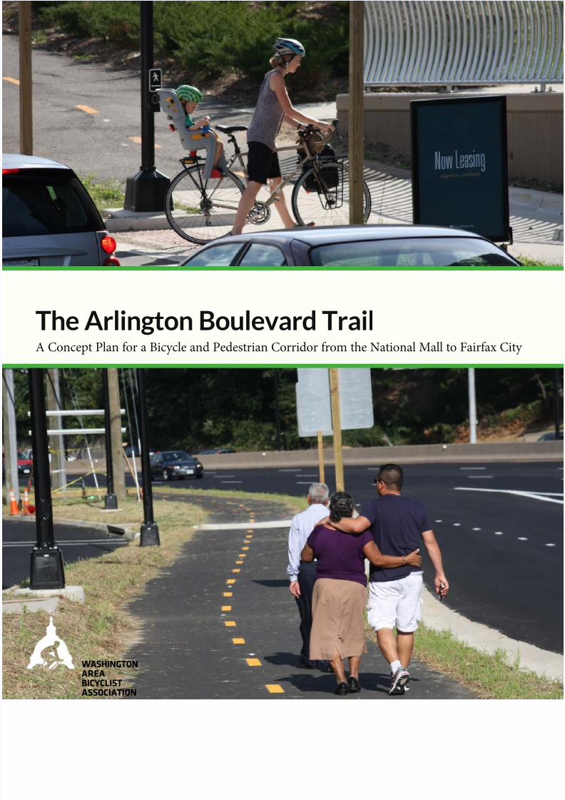
The Arlington Boulevard TrailA Concept Plan or a Bicycle and Pedestrian Corridor rom the National Mall to Fairax City
WASHINGTON
AREA
BICYCLIST
ASSOCIATION
8/10/2019 Arlington Boulevard Trail Concept Plan
http://slidepdf.com/reader/full/arlington-boulevard-trail-concept-plan 2/25
The Arlington Boulevard Trail A Concept Plan for a Bicycle and Pedestrian Corrido
from the National Mall to Fairfax City
Prepared by the Washington Area Bicyclist Associatio
and Andrew Olese
FALL 201
Washington Area Bicyclist Association © 2014
Suggested citation:
Te Arlington Boulevard rail: A Concept for a Bicycle and Pedestrian Corridor from the National Mall to Fairfax City
(2014) Washington Area Bicyclist Assocation, Washington D.C.
Te Washington Area Bicyclist Association is a nonprofit advocacy and education organization representing
the Washington area bicycling community.
Reproduction o inormation in this document or non-profit use is encouraged. Please use with attribution.
WASHINGTON
AREA
BICYCLIST
ASSOCIATION
Washington Area Bicyclist Association
2599 Ontario Road NW
Washington, D.C. 20009
P: (202) 518-0524
F: (202) 518-0936
waba.org
twitter.com/wabadc
acebook.com/wabadc
8/10/2019 Arlington Boulevard Trail Concept Plan
http://slidepdf.com/reader/full/arlington-boulevard-trail-concept-plan 3/25
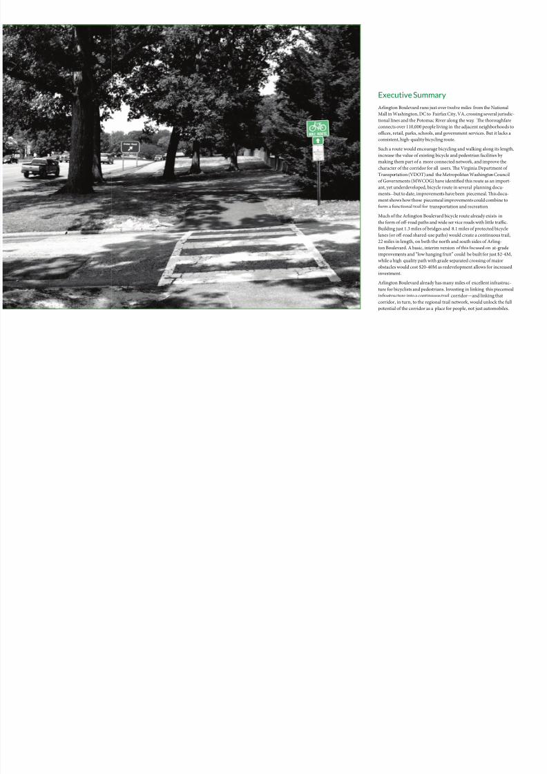
Executive Summary
Arlington Boulevard runs just over twelve miles from the National
Mall in Washington, DC to Fairfax City, VA, crossing several jurisdic
tional lines and the Potomac River along the way. e thoroughfare
connects over 110,000 people living in the adjacent neighborhoods to
offices, retail, parks, schools, and government services. But it lacks aconsistent, high-quality bicycling route.
Such a route would encourage bicycling and walking along its length
increase the value of existing bicycle and pedestrian facilities by
making them part of a more connected network, and improve the
character of the corridor for all users. e Virginia Department of
Transportation (VDOT) and the Metropolitan Washington Council
of Governments (MWCOG) have identified this route as an import-
ant, yet underdeveloped, bicycle route in several planning docu-
ments--but to date, improvements have been piecemeal. is docu-
ment shows how those piecemeal improvements could combine to
form a functional trail for transportation and recreation.
Much of the Arlington Boulevard bicycle route already exists in
the form of off-road paths and wide ser vice roads with little traffic.
Building just 1.3 miles of bridges and 8.1 miles of protected bicycle
lanes (or off-road shared-use paths) would create a continuous trail,
22 miles in length, on both the north and south sides of Arling-
ton Boulevard. A basic, interim version of this focused on at-grade
improvements and “low hanging fruit” could be built for just $2-4M,
while a high quality path with grade separated crossing of major
obstacles would cost $20-40M as redevelopment allows for increased
investment.
Arlington Boulevard already has many miles of excellent infrastruc-
ture for bicyclists and pedestrians. Investing in linking this piecemea
infrastructure into a continuous trail corridor—and linking that
corridor, in turn, to the regional trail network, would unlock the full
potential of the corridor as a place for people, not just automobiles.
8/10/2019 Arlington Boulevard Trail Concept Plan
http://slidepdf.com/reader/full/arlington-boulevard-trail-concept-plan 4/25
Table of Contents
Executive Summary
Glossary
The History of Arlington Boulevard
How Arlington Boulevard came to be, and why it’s time to consider a
bicycle and pedestrian path
Why Arlington Boulevard Needs a Trail
e benefits of an Arlington Boulevard Trail to DC, Arlington
County, Fairfax County, and the City of Fairfax
Arli ngto n Bo uleva rd Today
A detailed look at Arl ington Boulevard from a bicyclist’s perspective
Arli ngto n Bo uleva rd Tomo rrow
Beyond piecemeal improvements: What should the future of
Arlington Boulevard be?
Where It Will Take You
Routes and connections created and enabled by the Arlington
Boulevard Trail
Getting It Built
Technical information on design requirements, cost estimates, andstakeholders
Appe ndic es
References
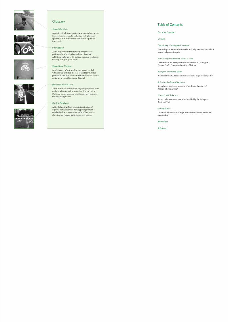
Glossary
Shared-Use Path
A path for bicyclists and pedestrians, physically separated
from motorized vehicular traffic by a curb plus open
space or barrier when there is insufficient separation
from roads.
Bicycle Lane
A one-way portion of the roadway designated for
preferential use by bicyclists, at least 5 feet wide.
Additional buffering of 2-3 feet may be added if adjacent
to heavy or higher speed traffic.
Shared Lane Marking
Also known as a “sharrow”, this is a bicycle symbol
with arrows painted on the road to ale rt bicyclists the
preferred location to ride to avoid hazards and to inform
motorists to expect bicycles on this road.
Protected Bicycle Lane
An on-road bicycle lane that is physically separated from
traffic by a barrier such as a raised curb or parked cars.
Protected bicycle lanes can be either one-way pairs or a
two-way configuration.
Contra-Flow Lane
A bicycle lane that flows opposite the direction of
adjacent traffic, separated from opposing traffic by a
standard yellow centerline and buffer. Oen used toallow two-way bicycle traffic on one-way streets.
8/10/2019 Arlington Boulevard Trail Concept Plan
http://slidepdf.com/reader/full/arlington-boulevard-trail-concept-plan 5/25
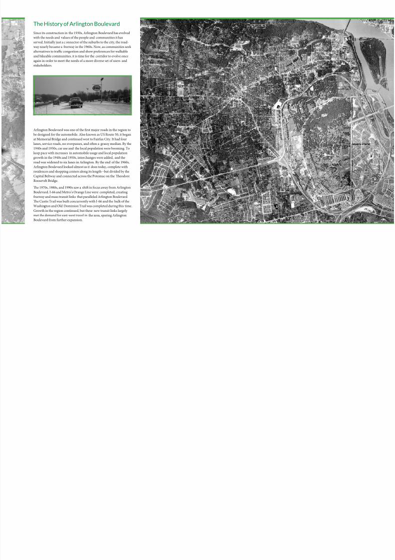
The History of Arlington Boulevard
Since its construction in the 1930s, Arlington Boulevard has evolved
with the needs and values o the people and communities it has
served. Initially just a c onnector o the suburbs to the city, the road-
way nearly became a reeway in the 1960s. Now, as communities seek
alternatives to traffic congestion and show preerences or walkable
and bikeable communities, it is time or the corridor to evolve once
again in order to meet the needs o a more diverse set o users and
stakeholders.
Arlington Boulevard was one o the first major roads in the region to
be designed or the automobile. Also known as US Route 50, it began
at Memorial Bridge and continued west to Fairax City. It had our
lanes, service roads, no overpasses, and ofen a grassy median. By the
1940s and 1950s, car use and the local population were booming. o
keep pace with increases in automobile usage and local population
growth in the 1940s and 1950s, interchanges were added, and the
road was widened to six lanes in Arlington. By the end o the 1960s,
Arlington Boulevard looked almost as it does today, complete with
residences and shopping centers along its length--but divided by the
Capital Beltway and connected across the Potomac on the Teodore
Roosevelt Bridge.
Te 1970s, 1980s, and 1990s saw a shif in ocus away rom Arlington
Boulevard. I-66 and Metro’s Orange Line were completed, creating
reeway and mass transit links that paralleled Arlington Boulevard.
Te Custis rail was built concurrently with I-66 and the bulk o the
Washington and Old Dominion rail was completed during this time.
Growth in the region continued, but these new transit links largely
met the demand or east-west travel in the area, sparing Arlington
Boulevard rom urther expansion.
8/10/2019 Arlington Boulevard Trail Concept Plan
http://slidepdf.com/reader/full/arlington-boulevard-trail-concept-plan 6/25
Why Arlington Boulevard Needs a Trail
It is hard to leave many neighborhoods along Arlington B oulevard
without getting into a car. Even i residents want to walk or bike, they
will not do so i there are impediments along their route. A contin-
uous, well-signed, sae trail along Arlington Boulevard will provide
residents alternatives to driving. A shared-use trail along Arlington
Boulevard will unlock access to neighborhoods and businesses, re-
move barriers among adjacent communities, increase the use o othe
acilities along its route, and bring ec onomic benefits by improving
the character o the corridor.
Unlock Access to Neighborhoods and Businesses
Consider the Fairax neighborhood bounded by Annandale Road an
Graham Road (see the map overlea). Shopping at Seven Corners is
only 2 miles away, a night out in Merrifield only 3 miles, and an office
in Rosslyn 8 miles. Yet without a sae route to these destination, trips
that could reasonably be taken on oot or by bike will not be.
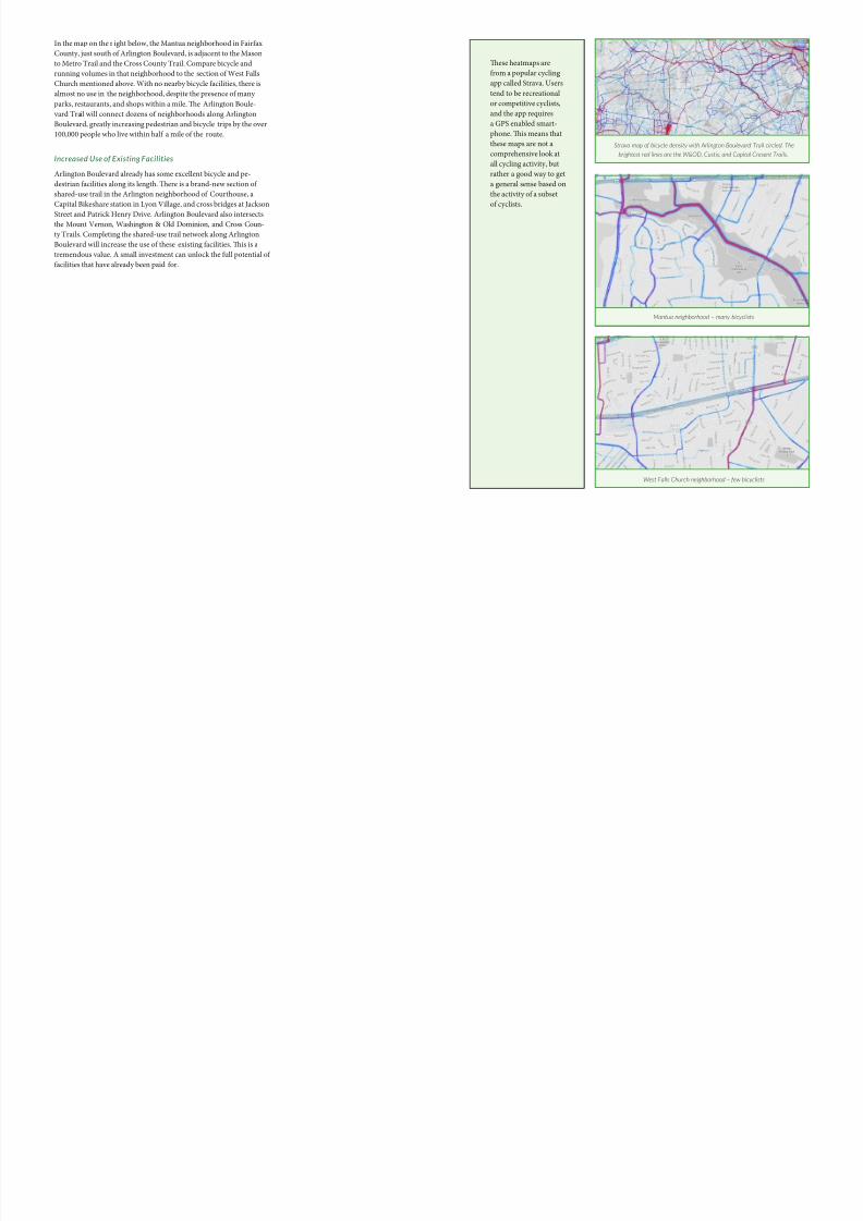
Te fitness app, Strava, provides data (albeit limited, see note on next
page) on where people do and do not ride. Tis data reveals a bicy-
clist and runner “dead zone” along Arlington Boulevard. Tis map
also demonstrates that, in contrast, regional bicycle and pedestrianroutes that are continuous, well-connected, and sae see heavy usage
rom runners and bicyclists. Intermittent acilities along roads like
Arlington Boulevard see almost no activity.
Sensibly, neighborhoods near good bike inrastructure have many
people biking, while neighborhoods lacking such acilities have ew.
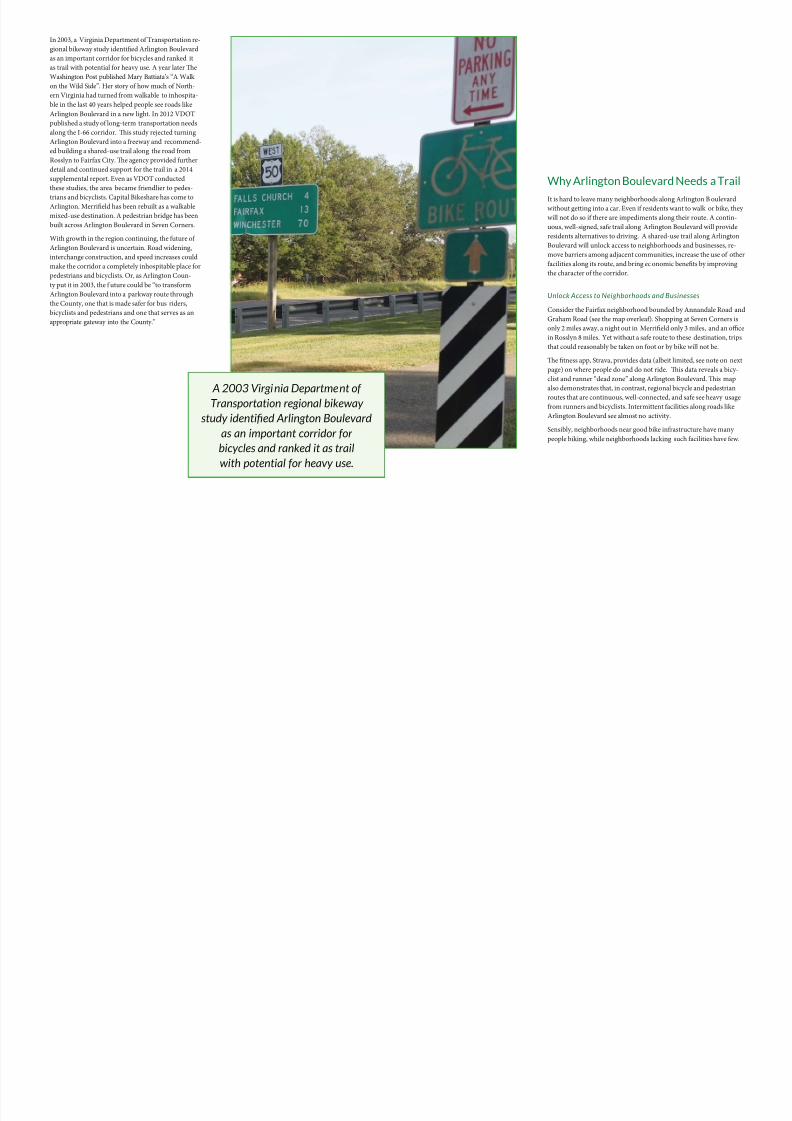
In 2003, a Virginia Department o ransportation re-
gional bikeway study identified Arlington Boulevard
as an important corridor or bicycles and ranked it
as trail with potential or heavy use. A year later Te
Washington Post published Mary Battiata’s “A Walk
on the Wild Side”. Her story o how much o North-
ern Virginia had turned rom walkable to inhospita-
ble in the last 40 years helped people see roads like
Arlington Boulevard in a new light. In 2012 VDO
published a study o long-term transportation needs
along the I-66 corridor. Tis study rejected turning
Arlington Boulevard into a reeway and recommend-
ed building a shared-use trail along the road rom
Rosslyn to Fairax City. Te agency provided urther
detail and continued support or the trail in a 2014
supplemental report. Even as VDO conducted
these studies, the area became riendlier to pedes-
trians and bicyclists. Capital Bikeshare has come toArlington. Merrifield has been rebuilt as a walkable
mixed-use destination. A pedestrian bridge has been
built across Arlington Boulevard in Seven Corners.
With growth in the region continuing, the uture o
Arlington Boulevard is uncertain. Road widening,
interchange construction, and speed increases could
make the corridor a completely inhospitable place or
pedestrians and bicyclists. Or, as Arlington Coun-
ty put it in 2003, the uture could be “to transorm
Arlington Boulevard into a parkway route through
the County, one that is made saer or bus riders,
bicyclists and pedestrians and one that serves as an
appropriate gateway into the County.”
A 2003 Virginia Department ofTransportation regional bikeway
study identifed Arlington Boulevard
as an important corridor for
bicycles and ranked it as trail
with potential for heavy use.
8/10/2019 Arlington Boulevard Trail Concept Plan
http://slidepdf.com/reader/full/arlington-boulevard-trail-concept-plan 7/25
In the map on the r ight below, the Mantua neighborhood in Fairax
County, just south o Arlington Boulevard, is adjacent to the Mason
to Metro rail and the Cross County rail. Compare bicycle and
running volumes in that neighborhood to the section o West Falls
Church mentioned above. With no nearby bicycle acilities, there is
almost no use in the neighborhood, despite the presence o many
parks, restaurants, and shops within a mile. Te Arlington Boule-
vard rail will connect dozens o neighborhoods along Arlington
Boulevard, greatly increasing pedestrian and bicycle trips by the over
100,000 people who live within hal a mile o the route.
Increased Use of Existing Facilities
Arlington Boulevard already has some excellent bicycle and pe-
destrian acilities along its length. Tere is a brand-new section o
shared-use trail in the Arlington neighborhood o Courthouse, a
Capital Bikeshare station in Lyon Village, and cross bridges at Jackson
Street and Patrick Henry Drive. Arlington Boulevard also intersectsthe Mount Vernon, Washington & Old Dominion, and Cross Coun-
ty rails. Completing the shared-use trail network along Arlington
Boulevard will increase the use o these existing acilities. Tis is a
tremendous value. A small investment can unlock the ull potential o
acilities that have already been paid or.
Mantua neighborhood – many bicyclists
West Falls Church neighborhood – few bicyclists
Strava map of bicycle density with Arlington Boulevard Trail circled. The
brightest red lines are the W&OD, Custis, and Capital Cresent Trails.
Tese heatmaps are
rom a popular cycling
app called Strava. Users
tend to be recreational
or competitive cyclists,
and the app requires
a GPS enabled smart-
phone. Tis means that
these maps are not a
comprehensive look at
all cycling activity, but
rather a good way to get
a general sense based on
the activity o a subset
o cyclists.
8/10/2019 Arlington Boulevard Trail Concept Plan
http://slidepdf.com/reader/full/arlington-boulevard-trail-concept-plan 8/25
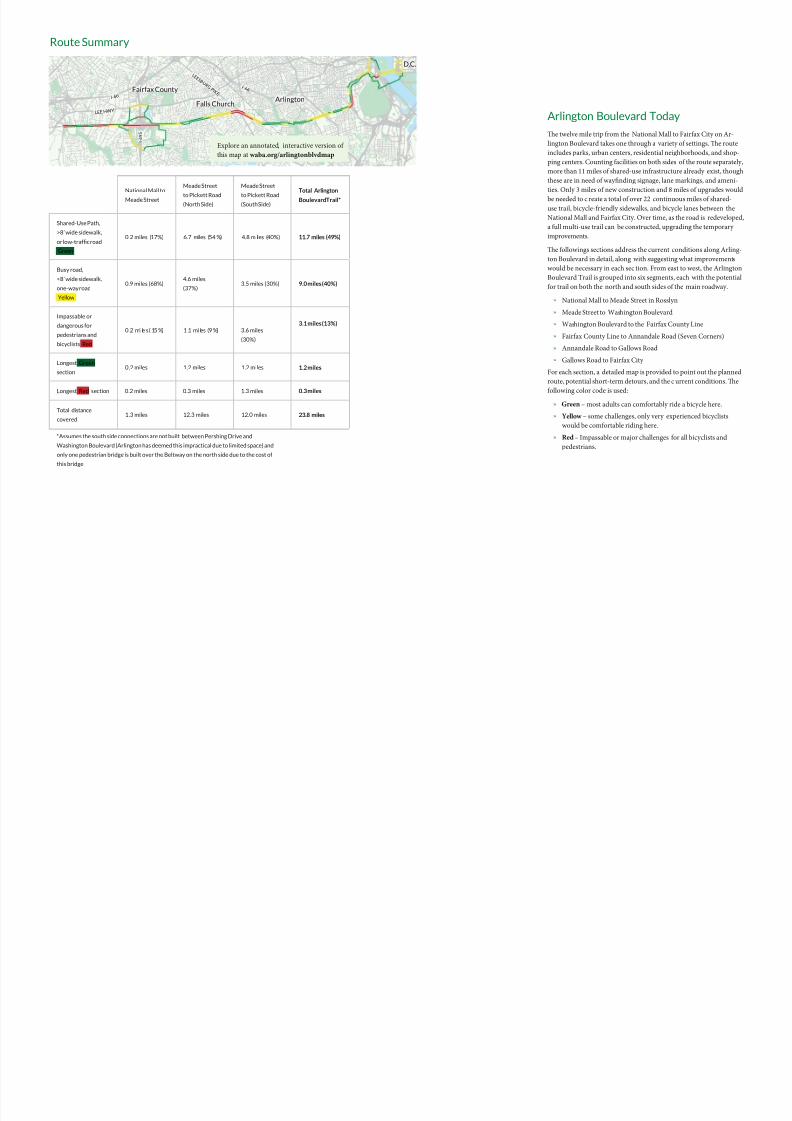
Arlington Boulevard Today
e twelve mile trip from the National Mall to Fairfax City on Ar-
lington Boulevard takes one through a variety of settings. e route
includes parks, urban centers, residential neighborhoods, and shop-
ping centers. Counting facilities on both sides of the route separately
more than 11 miles of shared-use infrastructure already exist, though
these are in need of wayfinding signage, lane markings, and ameni-
ties. Only 3 miles of new construction and 8 miles of upgrades would
be needed to c reate a total of over 22 continuous miles of shared-
use trail, bicycle-friendly sidewalks, and bicycle lanes between the
National Mall and Fairfax City. Over time, as the road is redeveloped
a full multi-use trail can be constructed, upgrading the temporary
improvements.
e followings sections address the current conditions along Arling-
ton Boulevard in detail, along with suggesting what improvements
would be necessary in each sec tion. From east to west, the Arlington
Boulevard Trail is grouped into six segments, each with the potential
for trail on both the north and south sides of the main roadway.
» National Mall to Meade Street in Rosslyn
» Meade Street to Washington Boulevard
» Washington Boulevard to the Fairfax County Line
» Fairfax County Line to Annandale Road (Seven Corners)
» Annandale Road to Gallows Road
» Gallows Road to Fairfax City
For each section, a detailed map is provided to point out the planned
route, potential short-term detours, and the c urrent conditions. e
following color code is used:
» Green – most adults can comfortably ride a bicycle here.
» Yellow – some challenges, only very experienced bicyclists
would be comfortable riding here.
» Red – Impassable or major challenges for all bicyclists and
pedestrians.
Route Summary
National Mall to
Meade Street
Meade Street
to Pickett Road(North Side)
Meade Street
to Pickett Road(South Side)
Total Arlington
Boulevard Trail*
Shared-Use Path,
>8’ wide sidewalk,
or low-trafc road
Green
0 .2 miles (17%) 6.7 miles (54 %) 4.8 m iles (40%) 11.7 miles (49%)
Busy road,
<8’ wide sidewalk,
one-way road
Yellow
0.9 miles (68%)4.6 miles
(37%)3.5 miles (30%) 9.0 miles (40%)
Impassable or
dangerous for
pedestrians and
bicyclists Red
0 .2 mi le s ( 15 %) 1 .1 mi les (9 %)
3.6 miles
(30%)
3.1 miles (13%)
Longest Green
section0.2 miles 1.2 miles 1.2 miles 1.2 miles
Longest Red section 0.2 miles 0.3 miles 1.3 miles 0.3 miles
Total distance
covered1.3 miles 12.3 miles 12.0 miles 23.8 miles
*Assumes the south side connections are not built between Pershing Drive and
Washington Boulevard (Arlington has deemed this impractical due to limited space) and
only one pedestrian bridge is built over the Beltway on the north side due to the cost of
this bridge
I - 6 6
L E E H W Y
L E E S B U R G
P I K E
Arlington
Fairfax County
Falls Church
D.C.
I - 4 9 5
I - 6 6
Explore an annotated, interactive version of
this map at waba.org/arlingtonblvdmap
8/10/2019 Arlington Boulevard Trail Concept Plan
http://slidepdf.com/reader/full/arlington-boulevard-trail-concept-plan 9/25
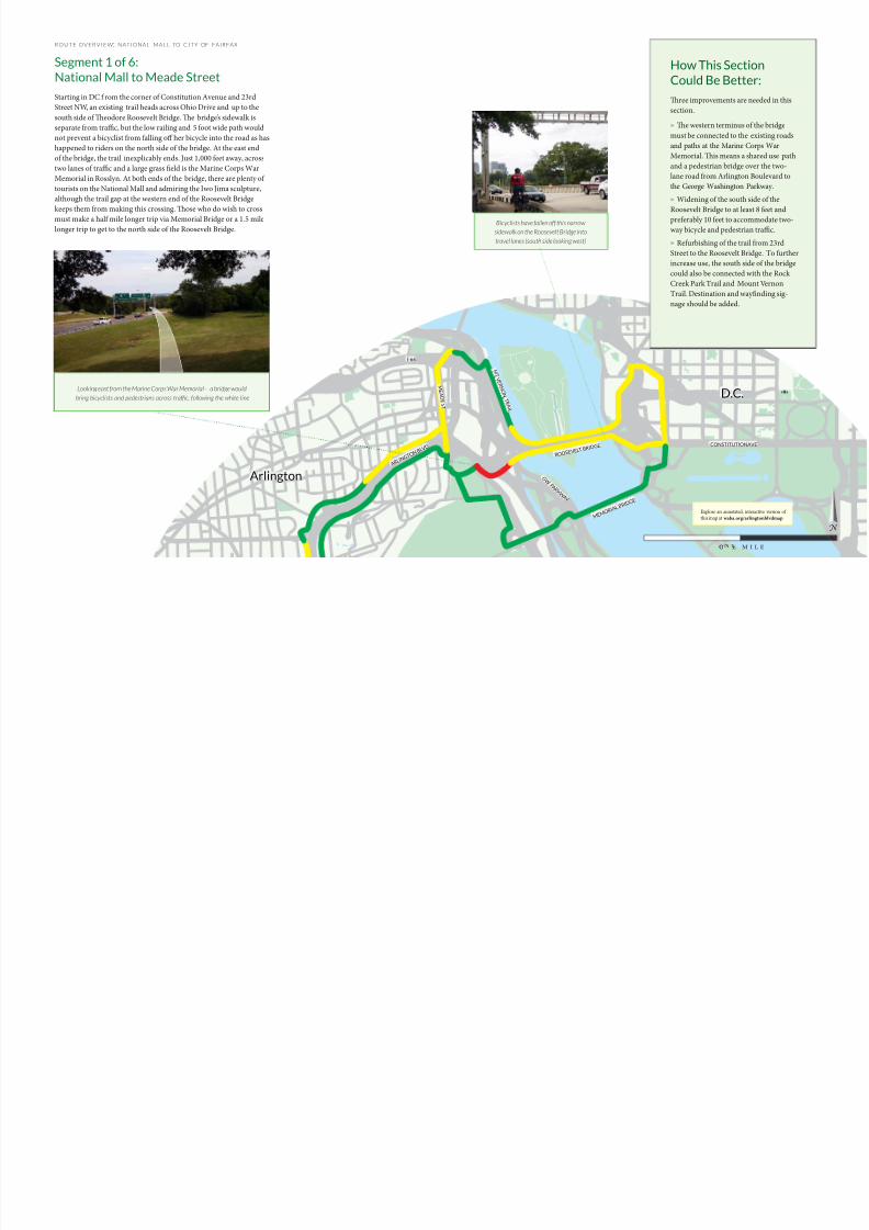
ROUTE OVERV IEW: NATIONAL MALL TO CITY OF FAIRFAX
Segment 1 of 6:
National Mall to Meade Street
Starting in DC f rom the corner of Constitution Avenue and 23rd
Street NW, an existing trail heads across Ohio Drive and up to the
south side of eodore Roosevelt Bridge. e bridge’s sidewalk is
separate from traffic, but the low railing and 5 foot wide path would
not prevent a bicyclist from falling off her bicycle into the road as has
happened to riders on the north side of the bridge. At the east end
of the bridge, the trail inexplicably ends. Just 1,000 feet away, across
two lanes of traffic and a large grass field is the Marine Corps War
Memorial in Rosslyn. At both ends of the bridge, there are plenty of
tourists on the National Mall and admiring the Iwo Jima sculpture,
although the trail gap at the western end of the Roosevelt Bridge
keeps them from making this crossing. ose who do wish to cross
must make a half mile longer trip via Memorial Bridge or a 1.5 mile
longer trip to get to the north side of the Roosevelt Bridge.
Looking east from the Marine Corps War Memorial – a bridge would
bring bicyclists and pedestrians across trafc, following the white line
Bicyclists have fallen off this narrow
sidewalk on the Roosevelt Bridge into
travel lanes (south side looking west)
How This Section
Could Be Better:
ree improvements are needed in this
section.
» e western terminus of the bridge
must be connected to the existing roads
and paths at the Marine Corps War
Memorial. is means a shared use path
and a pedestrian bridge over the two-
lane road from Arlington Boulevard to
the George Washington Parkway.
» Widening of the south side of the
Roosevelt Bridge to at least 8 feet and
preferably 10 feet to accommodate two-
way bicycle and pedestrian traffic.
» Refurbishing of the trail from 23rd
Street to the Roosevelt Bridge. To further
increase use, the south side of the bridge
could also be connected with the Rock
Creek Park Trail and Mount Vernon
Trail. Destination and wayfinding sig-
nage should be added.
I-66
A R L I N
G T O N
B L V D
CONSTITUTION AVE
R O O S E V E
L T B R I D G E
M E M O
R IA L B R
I D G E
G W P A R K W
A Y
M T V E R N O N T R A I L
M E A D E S T
Arlington
D.C.
Explore an annotated, interactive version of
this map at waba.org/arlingtonblvdmap
8/10/2019 Arlington Boulevard Trail Concept Plan
http://slidepdf.com/reader/full/arlington-boulevard-trail-concept-plan 10/25
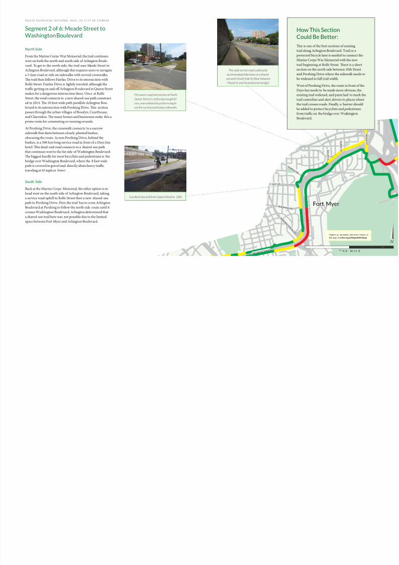
ROUTE OVERV IEW: NATIONAL MALL TO CITY OF FAIRFAX
Segment 2 of 6: Meade Street to
Washington Boulevard
North Side
From the Marine Corps War Memorial, the trail continues
west on both the north and south side of Arlington Boule-
vard. To get to the north side, the trail uses Meade Street to
Arlington Boulevard, although this requires users to navigate
a 5-lane road or ride on sidewalks with several crosswalks.
e trail then follows Fairfax Drive to its intersection with
Rolfe Street. Fairfax Drive is lightly traveled, although the
traffic getting on and off Arlington B oulevard at Queen Street
makes for a dangerous intersection there. Once at Rolfe
Street, the road connects to a new shared-use path construct-ed in 2014. e 10 foot wide path parallels Arlington Bou-
levard to its intersection with Pershing Drive. is section
passes through the urban villages of Rosslyn, Courthouse,
and Clarendon. e many homes and businesses make this a
prime route for commuting or running errands.
At Pershing Drive, the crosswalk connects to a narrow
sidewalk that darts between closely-planted bushes,
obscuring the route. Across Pershing Drive, behind the
bushes, is a 500 foot long service road in front of a Days Inn
hotel. is dead-end road connects to a shared-use path
that continues west to the far side of Washington Boulevard.
e biggest hurdle for most bicyclists and pedestrians is the
bridge over Washington Boulevard, where the 8 foot wide
path is covered in gravel and directly abuts heavy traffic
traveling at 45 mph or faster.
South Side
Back at the Marine Corps Memorial, the other option is to
head west on the south side of Arlington Boulevard, taking
a service road uphill to Rolfe Street then a new shared-usepath to Pershing Drive. Here the trail has to cross Arlington
Boulevard at Pershing to follow the north side route until it
crosses Washington Boulevard. Arlington determined that
a shared-use trail here was not possible due to the limited
space between Fort Myer and Arlington Boulevard.
W A S H
I N G T O
N B L V D
P E R S H I N G R D
F A I R F A X D R
R O
L F E S
T
Q U E E
N
S T
10TH ST
M E A D E S T
A R L I N G T O N
B L V D
This seven-road intersection at North
Queen Street is confusing enough forcars, even without bicyclists trying to
use the curving and bumpy sidewalks
This wide service road could easily
accommodate bike lanes or a shared-
use path (South Side Arl Blvd, between
Meade St and the pedestrian bridge)
Excellent new trail from Queen Street to 10th
How This Section
Could Be Better:
is is one of the best sections of existing
trail along Arlington Boulevard. Trail or a
protected bicycle lane is needed to connect the
Marine Corps War Memorial with the new
trail beginning at Rolfe Street. ere is a short
section on the north side between 10th Street
and Pershing Drive where the sidewalk needs to
be widened to full trail width.
West of Pershing Drive, the route in front of the
Days Inn needs to be made more obvious, the
existing trail widened, and paint laid to mark the
trail centerline and alert drivers to places wherethe trail crosses roads. Finally, a barrier should
be added to protect bicyclists and pedestrians
from traffic on the bridge over Washington
Boulevard.
Fort Myer
Explore an annotated, interactive version of
this map at waba.org/arlingtonblvdmap
8/10/2019 Arlington Boulevard Trail Concept Plan
http://slidepdf.com/reader/full/arlington-boulevard-trail-concept-plan 11/25
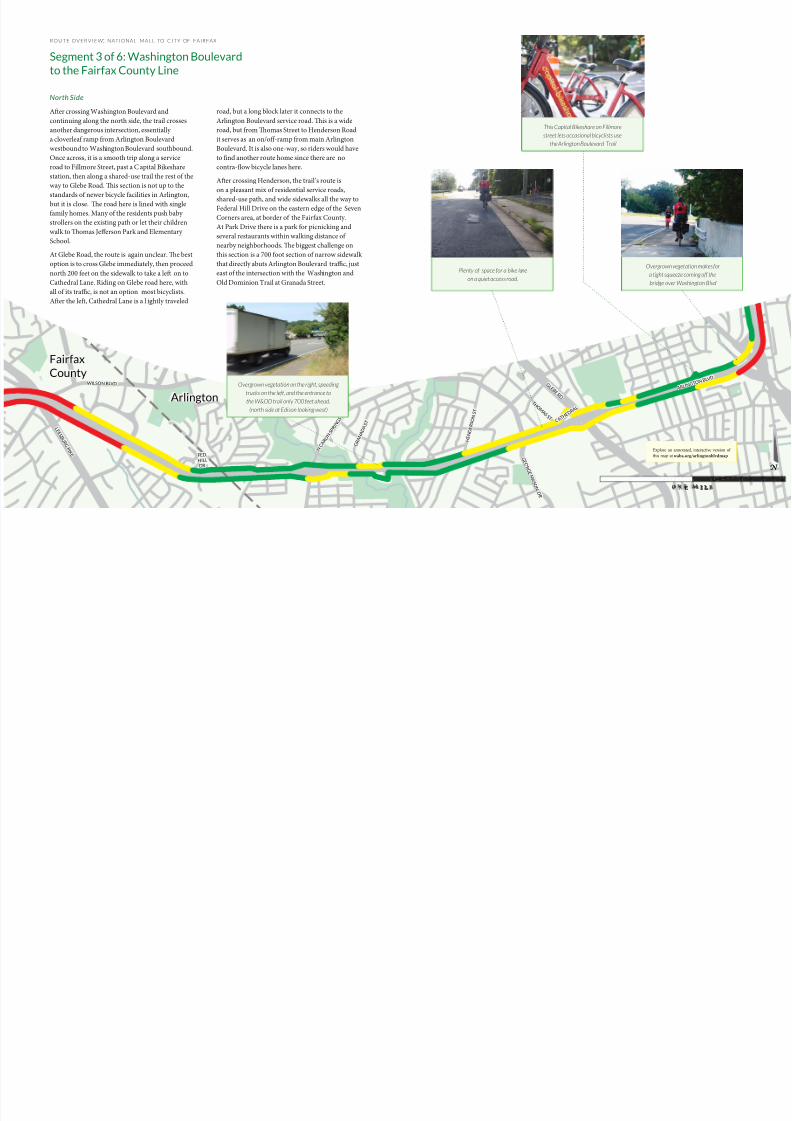
ROUTE OVERV IEW: NATIONAL MALL TO CITY OF FAIRFAX
Segment 3 of 6: Washington Boulevard
to the Fairfax County Line
North Side
Aer crossing Washington Boulevard and
continuing along the north side, the trail crosses
another dangerous intersection, essentially
a cloverleaf ramp from Arlington Boulevard
westbound to Washington Boulevard southbound.
Once across, it is a smooth trip along a service
road to Fillmore Street, past a C apital Bikeshare
station, then along a shared-use trail the rest of the
way to Glebe Road. is section is not up to the
standards of newer bicycle facilities in Arlington,but it is close. e road here is lined with single
family homes. Many of the residents push baby
strollers on the existing path or let their children
walk to omas Jefferson Park and Elementary
School.
At Glebe Road, the route is again unclear. e best
option is to cross Glebe immediately, then proceed
north 200 feet on the sidewalk to take a le on to
Cathedral Lane. Riding on Glebe road here, with
all of its traffic, is not an option most bicyclists.
Aer the le, Cathedral Lane is a l ightly traveled
road, but a long block later it connects to the
Arlington Boulevard service road. is is a wide
road, but from omas Street to Henderson Road
it serves as an on/off-ramp from main Arlington
Boulevard. It is also one-way, so riders would have
to find another route home since there are no
contra-flow bicycle lanes here.
Aer crossing Henderson, the trail’s route is
on a pleasant mix of residential service roads,
shared-use path, and wide sidewalks all the way to
Federal Hill Drive on the eastern edge of the Seven
Corners area, at border of the Fairfax County.
At Park Drive there is a park for picnicking and
several restaurants within walking distance of
nearby neighborhoods. e biggest challenge on
this section is a 700 foot section of narrow sidewalk
that directly abuts Arlington Boulevard traffic, just
east of the intersection with the Washington and
Old Dominion Trail at Granada Street.
A R L I N G
T O N B L V
D
G L
E B E R D
T H O M A S S T
H E N D E R S O N
S T
C A T H
E D R A
L
G E O R G E M A S O N D R
N C A R L I N
S P R I N
G S R D
G R A N A D A
S T
FED.
HILL
DR
L E E S B U R G P I K E
W ILSON BLV D
This Capital Bikeshare on Fillmore
street lets occasional bicyclists use
the Arlington Boulevard Trail
Overgrown vegetation on the right, speeding
trucks on the left, and the entrance to
the W&OD trail only 700 feet ahead.
(north side at Edison looking west)
Overgrown vegetation makes for
a tight squeeze coming off the
bridge over Washington Blvd
Plenty of space for a bike lane
on a quiet access road.
Arlington
Fairfax
County
Explore an annotated, interactive version of
this map at waba.org/arlingtonblvdmap
8/10/2019 Arlington Boulevard Trail Concept Plan
http://slidepdf.com/reader/full/arlington-boulevard-trail-concept-plan 12/25
ROUTE OVERV IEW: NATIONAL MALL TO CITY OF FAIRFAX
Segment 3 of 6: Washington Boulevard
to the Fairfax County Line
South Side
Back at Washington Boulevard, users can also follow an underpass
to arrive on the south side of Arlington Boulevard without having to
cross its six lanes of traffic. From here to near Glebe Road, the current
route is a mix of service roads and shared-use path. is service
road is narrow with parking on both sides. e path crosses several
roads and driveways that connect directly to Arlington B oulevard.
Finally, to get from the service road to Glebe Road, there is only an
overgrown footpath up a fairly steep hill.
From Glebe Road to George Mason Drive, there are only 5 foot wide
sidewalks to ride on, oen not in good condition and with little
buffer from traffic. Yet aer crossing George Mason Drive and before
Carlin Springs Road, the route is quite pleasant. It is all on service
roads, but they are adjacent to neighborhoods and get l ittle traffic.
Smooth travel is interrupted when the wide sidewalk leading up to
Carlin Springs Road ends and the route detours via a gravel path to a
neighborhood road. A block later, a narrow 5 foot sidewalk with poor
visibility brings connects to the crosswalk at Carlin Springs Road.
Once across Carlin Springs Road, the route follows a wide sidewalk
for a block before connecting to a lightly-traveled service road. e
border with Fairfax County comes just east of Olin Drive.
What Could Make
Segment 3 Better:
In this section, the north side needs
relatively minor improvements. Better
marking of places where the trail crosses
roads would improve safety at intersections
along the whole route. e trail under the
Jackson Street pedestrian bridge, just east
of Glebe Road, and just east of Granada
Street needs to be widened from its current
5 feet and better se parated from traffic. e
section from Glebe Road to Henderson
Road needs a protected bicycle lane or to
have the sidewalk replaced with a shared-use trail. On the south side trail is needed
along much of the length to replace narrow
sidewalks and gravel paths. On both sides,
bicycle lanes, preferably with buffers from
traffic, should be added to the lower-traffic
service road sections. Maintenance is a
major issue throughout this section.
G L E B E R D
G E O R G E M A S O N D R
N C A R L I N
S P R I N
G S R D
L E E S B U R G P I K E
W ILSON BLV D
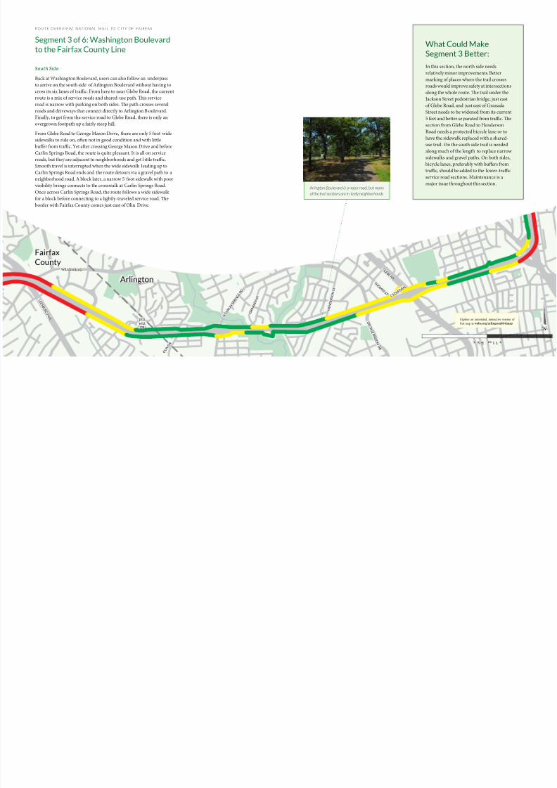
Arlington Boulevard is a major road, but many
of the trail sections are in leafy neighborhoods
O L I N
D R
T H O M A S S T
H E N D E R S O N
S T
C A T H
E D R A
L
G R A N A D A
S T
FED.
HILL
DR
Arlington
Fairfax
County
Explore an annotated, interactive version of
this map at waba.org/arlingtonblvdmap
8/10/2019 Arlington Boulevard Trail Concept Plan
http://slidepdf.com/reader/full/arlington-boulevard-trail-concept-plan 13/25
ROUTE OVERV IEW: NATIONAL MALL TO CITY OF FAIRFAX
Segment 4: Fairfax County Line to
Annandale Road (Seven Corners)
North Side
From the Fairfax County line to South Street on
the other side of Seven Corners, it is technically
possible to ride or walk, but few do. e service
road that parallels Arlington Boulevard is heavily
traveled at the shopping centers adjacent to Patrick
Henry Drive and it essentially becomes a highway
ramp connecting Arlington Boulevard and
Route 7. Even if riders were to walk their bicycles
through this mile-long section, there is no place for
pedestrians to cross Route 7. Once across Route 7,there is a wide service road that runs to Annandale
Road. Several intersections and traffic from the
many businesses makes this an undesirable place
to ride. Cars tend to “race” between stop signs
along the straight and wide road.
is area is home to many immigrants new to the
United States. Many new and existing residents
cannot afford to own multiple cars per house-
hold but would value safe and direct walking and
bicycling routes. ere is also a long-standing
Vietnamese presence here, centered on bustling
Eden Center just off Wilson Boulevard. is whole
segment is also filled with retail businesses, all the
way from the Fairfax County line to
Annandale Road.
South Side
On the south side, the service road from Carlin
Springs Road becomes busy between Olin Drive
and Patrick Henry Drive, as ramps allow traffic to
move quickly on and off of Arlington Boulevard.
To reach the other side of Route 7 f rom Patrick
Henry Drive, the only options are a narrow
sidewalk used by many pedestrians or illegally
bicycling the wrong way on a busy, fast-moving
service road. As on the north side, crossing Route
7 is not pedestrian or bicyclist friendly. Conditionsimprove west of Route 7 as the route returns to a
two-way service road. Yet as on the north side, car
traffic moves fast here.
What Could Make
Segment 4 Better?
is segment is one of the most
challenging for bicycling along the
entire route. e many businesses in
Seven Corners make it a desirable
destination, but access is difficult. For
through bicyclists and pedestrians,
detours around Seven Corners add
about 1.5 miles and require many road
crossings. Detailed study of this area
is needed to determine the best way to
route non-motorized traffic through
Seven Corners. If Arlington Boulevardis widened to six lanes here as planned,
a shared use trail could be added to run
under Route 7. Protected bicycle lanes
on the service roads to the east and west
could connect this underpass to the rest
of the Arlington Boulevard Trail.
L E E S B U R G P I K E
H I L L W O O D A V E
W ILSON BLVD
S L E E P Y
H O L L O W
R D
P A T R
I C K
H E N R Y D
R
O L I N
D R
With no sidewalks, pedestrians
have made their own t rails across
Seven Corenrs (at Route 7)
Neighbors could bicycle to shopping east of Seven Corners
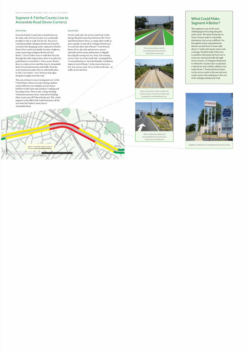
This service road has room for
cars and protected bicycle lanes
(South Street, north side)
When construction is done to widen the
road to six lanes, a shared-use path could
be added for a small additional cost.
Explore an annotated, interactive version of
this map at waba.org/arlingtonblvdmap
8/10/2019 Arlington Boulevard Trail Concept Plan
http://slidepdf.com/reader/full/arlington-boulevard-trail-concept-plan 14/25
ROUTE OVERV IEW: NATIONAL MALL TO CITY OF FAIRFAX
Segment 5: Annandale Road
to Gallows Road
North Side
Aer crossing Annandale Road, there is a wide
service road for bicyclists to use all the way
to I-495. Most of it is a pleasant route along
neighborhoods, although there are still some
challenges. In front of the commercial center
Graham Road, the service road sees heavier
traffic. East of Graham Road, the service road
becomes one-way eastbound, meaning that
riders are prohibited from continuing west. As
in Seven Corners, the area around Graham Roadhas a concentration of retail businesses and many
shoppers trying to navigate the area without a car.
At Jaguar Trail, the obvious route along Arlington
Boulevard is not an option. Arlington Boulevard is
a limited access freeway as it passes under Fairview
Park Drive, I-495, and Gallows Road. e best
option today is to take a 1.3 mile
detour north on
Fairview
Park Drive, west on Lee Highway, and south on
Gallows Road. is detour is long but the facilities
are good, with wide sidepaths on Fairview Park
and Gallows. Lee Highway has narrower sidewalks
but with good separation from traffic, except at the
I-495 HOT lane junction. Aer passing the new
Merrifield Mosaic District, which is bustling with
people walking to dinner and the movies, users
end up back on Arlington Boulevard.
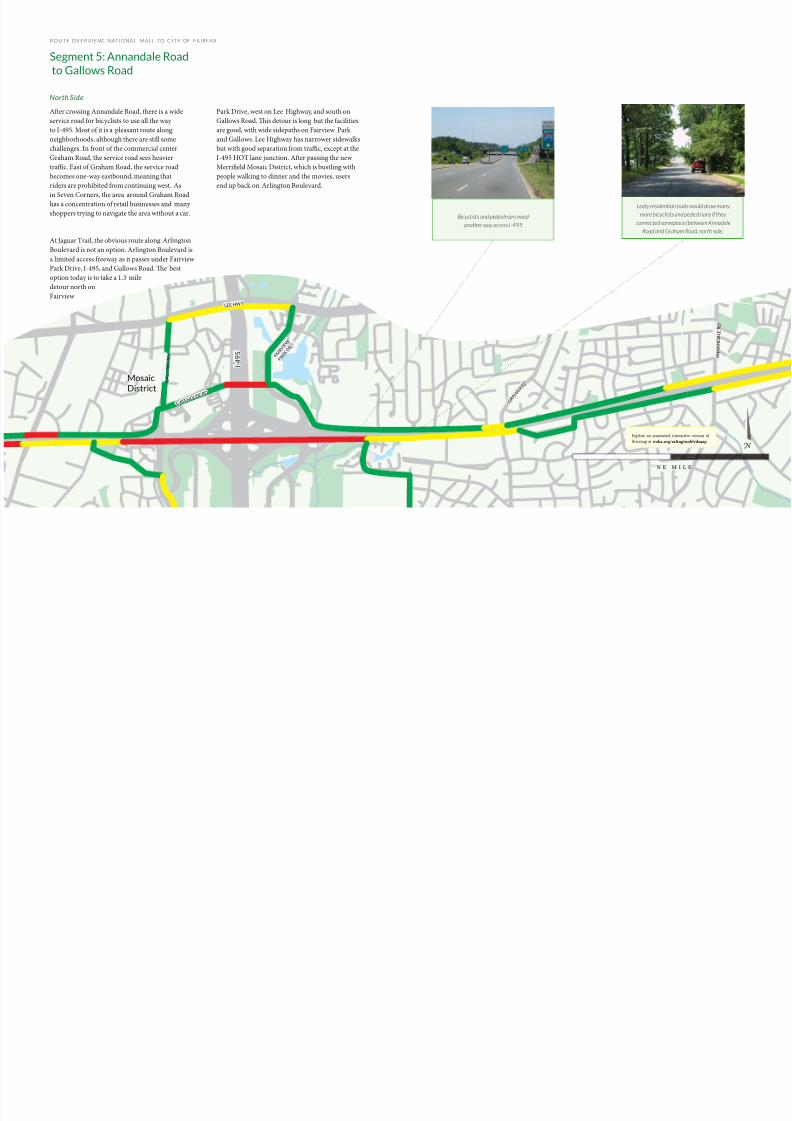
Leafy residential roads would draw many
more bicyclists and pedestrians if they
connected someplace (between Annadale
Road and Graham Road, north side)
G R A H A
M R D
A N N A N D A L E R D
G A L L O W S R D
GA T E H O
U S E R D
L E E H W Y
I - 4 9 5 F A
I R V I E W
P A R K
D R
Bicyclists and pedestrians need
another way across I-495
Mosaic
District
Explore an annotated, interactive version of
this map at waba.org/arlingtonblvdmap
8/10/2019 Arlington Boulevard Trail Concept Plan
http://slidepdf.com/reader/full/arlington-boulevard-trail-concept-plan 15/25
ROUTE OVERV IEW: NATIONAL MALL TO CITY OF FAIRFAX
Segment 5: Annandale Road to Gallows
Road
South Side
On the south side, once across Annandale Road, conditions are good
all the way to Graham Road. ere is a new shared-use path outside
the Honda dealership, then lightly-used residential service roads the
rest of the way. Conditions deteriorate between Graham Road and
Jaguar Trail. e service road becomes narrow, busy, and one way
eastbound. Near Jaguar Trail the road ends and the only route is on a
very narrow, 4 foot wide sidewalk.
As on the north side, a detour is necessary to cross I-495. e south
side alternative is to cut through neighborhoods and parks, past Falls
Church High School, to reach Gallows Road. From there, extensive
riding on sidewalks along Gallows Road would be necessary to return
to Arlington Boulevard. e Lee Highway detour would add 1.5
miles, the Gallows Road detour 1.9 miles by the time users reached
the sidewalk at Williams Drive.
How Segment 5
Could Be Better:
Improvements needed in this section
consist of protected bicycle lanes on
service roads, shared-use path where
there is no existing road and sidewalkcombination, better intersection
crossings, and a direct route over I-495
Such a bridge will likely be the single
most costly element of the trail. Yet the
are potential locations just north and
south of Arlington Boulevard where a
bicycle/pedestrian bridge could be buil
over the Capital Be ltway.
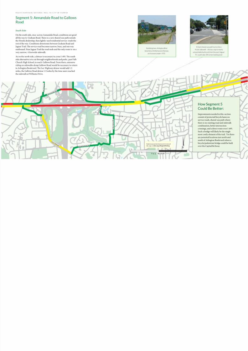
8-foot shared-use path turns into a
4-foot sidewalk – this bus stop is nearly
unreachable by bicycle from the east (Jaguar
Trl, south side, SW corner looking east)
No biking here. Arlington Blvd
becomes a limited access freeway
as it crosses under I-495.
G R A H
A M R D
A N N A N D A L E R D
G A L L O W S R D
W I L L I A
M S D R
G A L L O W S R D
GA T E H O
U S E R D
H O L L Y H I L L
D R
J A G U A R
T R
MARC D R
C AM P ALG E R AV E
HOLMES RUN DR
F A I R V I E W P A R K D
R
Explore an annotated, interactive version of
this map at waba.org/arlingtonblvdmap

8/10/2019 Arlington Boulevard Trail Concept Plan
http://slidepdf.com/reader/full/arlington-boulevard-trail-concept-plan 16/25
ROUTE OVERV IEW: NATIONAL MALL TO CITY OF FAIRFAX
Segment 6: Gallows Road
to Fairfax City
North Side
From Gallows Road to Pickett Road at the Fairfax
City boundary on the north side, the current
facilities include some of the nicest shared-use
path and quietest service roads of the whole route,
mixed block-by-block with a complete lack of
any bicycle or pedestrian facility. On the 1.6 mile
section from Prosperity Drive to Pickett Road,
only about a third of a mile is impassable, but these
three 650 foot gaps would keep someone f rom
making this trip on foot or by bike.
South Side
e south side route from Gallows Road is more
challenging. Currently, a detour through office
parks is needed to reach the start of sidewalk
at Williams Drive, about 1/3 of a mile away
from Gallows Road. From Williams Drive to
Prosperity Drive there is only 5 foot wide sidewalk.
Aer crossing Prosperity, there is no bicycle or
pedestrian facility for over half a mile until a one
block long, privately owned service road west of
Barkley Drive. From here to C ovington Street there
is again no place to bike. Between Covington Street
and Stonehurst Lane there is a quiet service road
and the entrance to the Cross County Trail. is
service road then ends with no way to continue
west to Pickett Road and the end of Arlington
Boulevard Trail route.
Connections
At Pickett Road, the Arlington Boulevard Trail will
connect with at the Mason to Metro trail. To the
right, the Vienna Metro station is 1.5 miles away.
To the le it is 2.7 miles to the center of Fairfax
City and 3.6 miles to George Mason University.
How Segment 6
Could Be Better:
In this segment, the existing lengths of
shared use trail should be connected
to bridge the gaps between service
roads and protected bicycle lanes
added to the service roads. e biggest
challenge is between Williams Drive
and Prosperity Drive, where the Fairfax
County Water Authority and associated
buildings leave no room for a route
adjacent to Arlington Boulevard. A
detour north to Prosperity Drive here
would work if Prosperity Drive could becrossed away from its intersection with
Arlington Boulevard. On the south side
greater lengths of new trail are needed,
sidewalks would need to be widened to
trail width, and a connection made with
Gallows Road.
The western-most of the many trail connections
made by the Arlington Boulevard Trail
Some excellent shared-use path already
exists outside the Beltway (north side,
just west of Barkley Gate Rd)
Yet each path or service road ends
without connecting anywhere (west
of Prosperity Drive, north side)
G A L L O W S R D
P R O P S
E R I T Y
D R
C E
D A R R D
B A R K L E Y D R
B A R K L E Y D R
P I C K E T T R D
C O V I N G T O N S T
W I L L I A
M S D R
8/10/2019 Arlington Boulevard Trail Concept Plan
http://slidepdf.com/reader/full/arlington-boulevard-trail-concept-plan 17/25
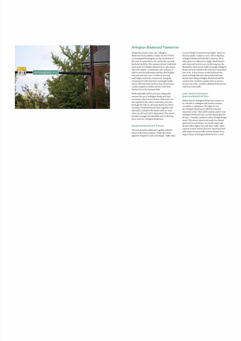
Arlington Boulevard Tomorrow
Within the next ew years, the Arlington
Boulevard rail could be a reality. In 2014 VDO
recommended ocusing first on the north side othe road. As noted above, the north side currently
has better acilities. Te commercial and residential
areas north o Arlington Boulevard are also denser.
Te trail could be a continuous, sae, and easy-to-
ollow route or pedestrians and bicyclists headed
both east and west. Just 1.3 miles o new trail
and bridges need to be constructed. Along the
remaining 4.6 miles that have meaningul traffic
and no off-road routes or bicyclists, bicycle lanes
would complete a useable, interim route rom
Fairax City to the National Mall.
While sidewalks and bicycle lanes will greatly
increase the use o Arlington Boulevard, they
are merely a short-term solution. I the trail is to
have appeal or the entire community, everyone
rom age 8 to 108, an off-road, shared-use trail is
necessary. Protected bicycle lanes, together with
sidewalks, could provide similar saety in areas
where an off-road trail is impractical. Tis cannot
be built overnight, but should be part o the long-
term vision or Arlington Boulevard.
Arl ingt on B oule vard as a Free way
Te trail should be addressed together with the
uture o the entire roadway. While the road is
signed at 45mph or most o its length, traffic ofen
races at 55mph or aster between lights. Tese are
reeway speeds. At places, such I-495 or Rosslyn,
Arlington Boulevard looks like a reeway. Yet inother places it is adjacent to single -amily homes
and connected to driveways. In the long run, the
demand or more speed could encourage Arlington
Boulevard to be rebuilt as the reeway it sometime
tries to be. A true reeway would eliminate the
many crossings that slow down pedestrian and
bicycle users along Arlington Boulevard and the
construction would be a perect time to invest a
ew percent o the cost into a dedicated shared-use
trail away rom traffic.
Lower Speeds on Arlington
Boulevard Benefit All Users
Rather than let Arlington Boulevard continue to
be a divider in Arlington and Fairax counties,
it could be a centerpiece. Te right-o-way
or Arlington Boulevard is 200 eet wide and
sometimes wider. Tis width could be used to turn
Arlington Boulevard into a world-class acility or
all users. Consider a parkway with a 30 mph design
speed. Tis slower-speed road needs less cleared
space next to travel lanes, no on/off ramps, and
shorter yellow lights. For rush-hour traffic, when
capacity is most critical, the lower speed may have
little impact because traffic volume already slows
large sections o Arlington Boulevard to a crawl.
8/10/2019 Arlington Boulevard Trail Concept Plan
http://slidepdf.com/reader/full/arlington-boulevard-trail-concept-plan 18/25
Coordinated lights could be used to reinforce the slower speed limit
while allowing traffic to flow for miles without needing to stop at a
light. Slower speeds mean less frequent and less severe crashes.
For public transportation users, a slower-speed road would be more
pleasant to stand next to while waiting for the bus. Additionally,
the perceived disadvantage of a bus is reduced when general traffic
and public transportation are traveling at similar speeds. With its
direct access to DC, Arlington Boulevard could even become an
advantageous place to ride public transit if a bus rapid transit (BRT)
system were put in place, using dedicated lanes separate from rush-
hour jams.
For bicyclists and pedestrians, a slower speed road means more space
for a multi-use trail, more trees, and easier road crossings. For people
living along the road, more trees and slower moving traffic means less
noise and a more enjoyable environment. Improving the character
of Arlington Boulevard would boost property values, offsetting the
cost of any road work. In the three mile se gment from WashingtonBoulevard to the Fairfax County line, the total value of residences
that look out onto Arlington Boulevard is about $100 million. Studies
on the effect of noise show that a change from 40 mph traffic to 30
mph traffic has the same effect as removing half the vehicles from the
road and could boost property values by 3-6%. A modest 5% boost
from a more pleasant Arlington Boulevard would create over $1.5
million of value per mile.
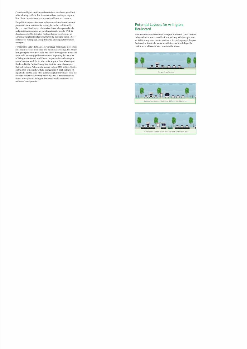
Potential Layouts for Arlington
Boulevard
Here are three cross-sections of Arlington Boulevard. One is the road
today and one is how it could look as a parkway with bus rapid tran-
sit. While it may seem counterintuitive at first, redesigning Arlington
Boulevard to slow traffic would actually increase the ability of the
road to serve all types of users long into the future.
Future Cross Section – Rush-Hour BRT and Side Bike Lanes
Current Cross Section
Future Cross Section – Rush-Hour BRT and C enter Bike Lane
8/10/2019 Arlington Boulevard Trail Concept Plan
http://slidepdf.com/reader/full/arlington-boulevard-trail-concept-plan 19/25
Where It Will Take You
Arlington Boulevard is well-traveled by cars
because it connects to so many places. Te benefits
o this connection will also extend to pedestrians
and bicyclists on the Arlington Boulevard rail.
Te trail will increase access to and useulness o
other transit options. Here is a summary o those
transit links, connections to other trails, and a
selection o destinations within hal a mile o the
Arlington Boulevard rail’s route.
Transportation Links
Te Arlington Boulevard rail will provide
connections along its route to Metrorail, bus
routes, Capital Bikeshare, and existing shared-usetrails. Metrorail stations near Arlington Boulevard
will allow pedestrian users to continue on to
arther destinations. Bicyclists can park and ride
during rush hour or take their bicycles on the
Metro on weekends and off-hours. Te Arlington
Cemetery station lies three quarters o a mile south
o the trail route and Rosslyn is just a quarter o
a mile north. C ourthouse, Clarendon, Virginia
Square, Ballston, East Falls Church, Dunn Loring,
and Vienna are all less than 1.2 miles rom the trail
route.
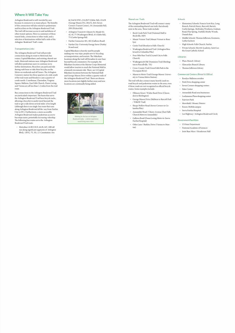
Bus connections to the Arlington Boulevard rail
are particularly important. Te buses that serve
the Arlington Boulevard rail have bicycle racks,
allowing a bicyclist to easily travel beyond the
trail or get a ride down several miles o its length
(although there is no single bus route that runs
along Arlington Boulevard all the way rom Fairax
City to DC). Furthermore, a more accessible
Arlington Boulevard makes pedestrian access to
bus stops easier, potentially increasing ridership.
Te ollowing bus routes serve the Arlington
Boulevard rail route:
» Metrobus 1A/B/C/E/Z, 4A/B, 16Y, 10B (all
run along significant segments o Arlington
Blvd), 13F/G, 7Y, H1, L1 Constitution Ave
& 23rd St NW), 23A/B/ (Glebe Rd), 22A/B
(George Mason Dr), 28A/X, 26A (Seven
Corners ransit Center), 3A (Annandale Rd),
29N (Pickett Rd)
» Arlington ransit 61 (Queen St, Meade St),
42, 45, 77 (Washington Blvd), 41 (Glebe Rd),
75 (Carlin Springs Rd)
» Fairax Connector 401, 402 (Gallows Road)
» Fairax City-University Energy Saver (Nutley
St and west)
Capital Bikeshare is heavily used by people
making one-way trips, people new to bicycling
as transportation, and tourists. Te bikeshare
locations along the trail will broaden its user base
beyond bicycle commuters. For example, the
Bikeshare location at the Marine Corps Memorial
would allow tourists to reach the National Mall in
a leisurely ten minute ride. Tere are 14 Capital
Bikeshare locations between the National Mall
and George Mason Drive within a quarter mile o
the Arlington Boulevard rail. Tere are dozens
more locations just slightly arther away and new
locations are continually being added.
Shared-use Trails
Te Arlington Boulevard rail will connect many
o the outstanding shared-use trails that already
exist in the area. Tese trails include:
» Rock Creek Park rail (National Mall to
Rockville, MD)
» Mount Vernon rail (Mount Vernon to Ross-
lyn)
» Custis rail (Rosslyn to Falls Church)
» Washington Boulevard rail (Arlington Bou-
levard to Columbia Pike)
» Four Mile Run rail (Crystal City to Falls
Church)
» Washington & Old Dominion rail (Shirling-
ton to Purcellville, VA)
» Cross-County rail (Great Falls Park to the
Occoquan River)
» Mason to Metro rail (George Mason Univer-
sity to Vienna Metro Station)
Te trail will also connect many heavily used on-
road bicycle and pedestrian routes in the area, even
i those roads are not recognized as official bicycle
routes. Some examples include:
» Fillmore Street / Walter Reed Drive (Claren-
don to Shirlington)
» George Mason Drive (Ballston to Barcof Park
/ W&OD rail)
» Sleepy Hollow Road (Seven Corners to Co-
lumbia Pike)
» Annandale Road / Cherry Avenue (East Falls
Church Metro to Annandale)
» Gallows Road (Dunn Loring Metro to Inova
Fairax Hospital)
» Oden Lane / Barkley Drive (Vienna to Man-
tua)
Schools
» Elementary Schools: Francis Scott Key, Long
Branch, Patrick Henry, Barcrof, Barrett,
Carlin Springs, McKinley, Westlawn, Graham
Road, Pine Spring, Fairhill, Mosby Woods,
Daniels Run
» Middle Schools: Tomas Jefferson, Kenmore,
Luther Jackson
» High Schools: Falls Church, Fairax
» Private Schools: Merritt Academy, Saint Leo
the Great Catholic School
Libraries
» Plaza Branch Library
» Glencarlyn Branch Library
» Tomas Jefferson Library
Commercial Centers (Retail & Office)
» Rosslyn-Ballston corridor
» Park Drive shopping center
» Seven Corners shopping centers
» Eden Center
» Annandale Road area businesses
» Loehmanns Plaza shopping center
» Fairview Park
» Merrifield / Mosaic District
» Exxon-Mobile campus
» Inova Fairax Hospital
» Lee Highway / Arlington Boulevard Circle
Government Facilities
» US State Department
» National Academy o Sciences
» Joint Base Myer / Henderson Hall
Waiting for the bus on Arlington
Boulevard today – a better experience
would bring more riders
8/10/2019 Arlington Boulevard Trail Concept Plan
http://slidepdf.com/reader/full/arlington-boulevard-trail-concept-plan 20/25
» Arlington County Government Offices & Courts
» National Science Foundation
» National Foreign Affairs raining Center
» Deense Health Headquarters
» Fairax County Water Authority
Parks & Monuments
» National Mall
» West Potomac Park
» Teodore Roosevelt Island
» US Marine Corps War Memorial
» Arlington National Cemetery
» Lady Bird Johnson Park
» Fillmore Park
» Tomas Jefferson Park
» Lubber Run Park
» Glencarlyn Park
» Jefferson Village Park
» Bluemont Park
» Barkley Park
» Mantua Park
» owers Park
Getting it Built
Design Issues
o the extent possible, any new construction along the trail corridor
should be done in accordance with the American Association o State
and Highway ransportation Officials’ (AASHO) Guide or the De-
velopment o Bicycle Facilities and the National Association o City
ransportation Officials (NACO) Urban Bikeway Design Guide.
Existing acilities that do not meet c urrent standards but which meet
the needs o trail users need only be upgraded when construction is
done or other reasons. Te ollowing AASHO guidelines apply to
the Arlington Boulevard rail:
» One-way bicycle lanes should be a minimum o five eet wide, or
wider i they are next to car parking or a curb and gutter.
»rails shall be a minimum o ten eet wide or two-way bicycletraffic. In addition, a minimum o two eet wide graded area
should be maintained adjacent to both side o the pavement to
provide clearance rom trees, poles, walls, ences, guardrails, or
other obstructions. Wider trails than the minimum are pre-
erred.
» Minimum design speed should be 20 mph when the grade is less
than 4% and 30 mph when the grade exceeds 4%. Grade should
be 5% or less.
» Sight distances should allow bicyclists adequate stopping sight
distances. For a design speed o 20 mph on a level grade, the
minimum stopping distance is 125 eet.
» On trails, a center yellow line should separate two-way bicycle
traffic.
» Overpasses, underpasses, and bridges should be the same width
as the path, including clear width.
» Railings or barriers along the path should be a minimum o 4.5
eet high.
» Drainage grates should be located outside the travel path o
cyclists.
» Placement o traffic control signals (e.g., stop signs, traffic lights)
should consider the operating characteristics o bicyclists,
including a reluctance to repeatedly stop and return to traveling
speed.
Signage is e xtremely important to communicating that the Arlington
$2–5 million woulda strong beginning
Arlington Boulevarand $40 million coit completed as a 2high-quality bicyclepedestrian facility.
8/10/2019 Arlington Boulevard Trail Concept Plan
http://slidepdf.com/reader/full/arlington-boulevard-trail-concept-plan 21/25
Boulevard rail is a continuous route designed or
bicyclists and pedestrians. Signs also help build
a brand or the trail, helping users know what
to expect. Te ollowing types o signs should
be provided: directional / location (mileage to
certain points, mile markers), traffic signs (stop,
yield, watch or cars), signs to the trail rom transit
stations and other trails. Signs should be uniorm
along the entire length, despite different managing
agencies.
Costs
Te cost to complete the Arlington Boulevard rail
depends greatly on the quality o service desired
and ar more study will be required as DC, Arling-
ton County, and Fairax County detail exactly the
improvements to be made. At this time, costs canbe estimated using the 2012 VDO I-66 Multi-
modal Study, the 2014 Supplement to that study,
and a bottom-up approach using cost per mile
or required improvements (e.g., $15,000/mile or
painting bicycle lanes or $500,000 per mile or a
new shared use path). All dollar amounts given are
in 2014 dollars.
A bare-minimum interim trail, with no bridge
over I-495, little additional pavement, and a lot
o bicycle lane and shared lane markings would
cost approximately $2-5 million. Tat total would
increase to $5-7 million or the trail to run on both
the north and side o Arlington Boulevard. Up-
grading to shared-use path and protected bicycle
lanes would increase the total cost to about $5 mil-
lion or the north side and slightly less than twice
that or a trail on both sides.
Building new bridges and upgrading old ones
would be the most expensive part o the Arlington
Boulevard rail. A new pedestrian bridge overI-495 would cost $5-10 million or more but over-
comes a major obstacle in Fairax County better
than either the Lee Highway or Gallows Road
sidewalks. A bridge or tunnel at Seven Corners
would also cost several million dollars as a stand-
alone project. Adding a bridge between the Marine
Corps War Memorial and the south side o the
Roosevelt Bridge would likely cost around $3-5
million. Finally, widening the Teodore Roosevelt
Bridge sidewalk rom under 5 eet to a more appro-
priate 8 or 10 eet is another multi-million dollar
project. However, many o these projects can be
accomplished when work is done or other reasons.
A direct trail route through Seven Corners could
be built when Fairax County’s planned widening
o Arlington Boulevard and Route 7 is completed.
DC plans to spend $110 million in the next several
years to rehabilitate aging bridges, including the
50-year old Teodore Roosevelt Bridge. Te side-walks on Key Bridge were widened by over 4 eet
during rehabilitation in 1987 – similar widening
could be done as part o the upcoming Teodore
Roosevelt Bridge work.
otaling all the costs, $2-5 million would make a
strong beginning to the Arlington B oulevard rail
and $40 million could see it completed as a 22 mile
high-quality bicycle and pedestrian acility. It is
important to note that this is only a rough order
o magnitude estimate o costs – accurate enough
to say that the complete trail will cost closer to $10
million than $1 million or $100 million. Fund-
ing should be prioritized to address the locations
with the best cost-to-benefit ratio. For example,
connecting the Roosevelt Bridge to Meade Street
would fill in a major gap while requiring less than
1,000 eet o new trail. Low cost, interim solutions,
such as bike lanes on low-traffic streets or 600-oot
sections o shared-use path can be completed soon
to build support or and prove the useulness o the
complete shared-use path. Further detail on cost
estimates can be ound in the appendix.
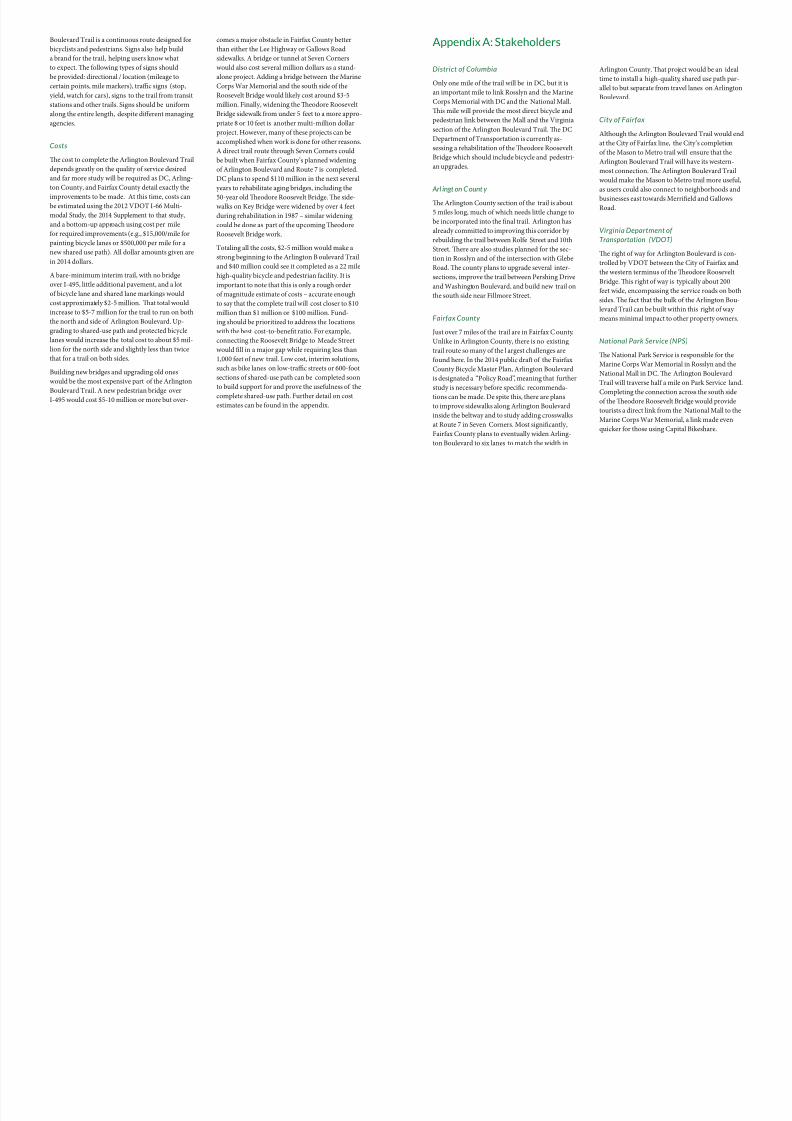
Appendix A: Stakeholders
District of Columbia
Only one mile o the trail will be in DC, but it is
an important mile to link Rosslyn and the Marine
Corps Memorial with DC and the National Mall.
Tis mile will provide the most direct bicycle and
pedestrian link between the Mall and the Virginia
section o the Arlington Boulevard rail. Te DC
Department o ransportation is currently as-
sessing a rehabilitation o the Teodore Roosevelt
Bridge which should include bicycle and pedestri-
an upgrades.
Arl ingt on C ount y
Te Arlington County section o the trail is about
5 miles long, much o which needs little change to
be incorporated into the final trail. Arlington has
already committed to improving this corridor by
rebuilding the trail between Role Street and 10th
Street. Tere are also studies planned or the sec-
tion in Rosslyn and o the intersection with Glebe
Road. Te county plans to upgrade several inter-
sections, improve the trail between Pershing Drive
and Washington Boulevard, and build new trail on
the south side near Fillmore Street.
Fairfax County
Just over 7 miles o the trail are in Fairax C ounty.
Unlike in Arlington County, there is no existing
trail route so many o the l argest challenges are
ound here. In the 2014 public draf o the Fairax
County Bicycle Master Plan, Arlington Boulevard
is designated a “Policy Road”, meaning that urther
study is necessary beore specific recommenda-tions can be made. De spite this, there are plans
to improve sidewalks along Arlington Boulevard
inside the beltway and to study adding crosswalks
at Route 7 in Seven Corners. Most significantly,
Fairax County plans to eventually widen Arling-
ton Boulevard to six lanes to match the width in
Arlington County. Tat project would be an ideal
time to install a high-quality, shared use path par-
allel to but separate rom travel lanes on Arlington
Boulevard.
City of Fairfax
Although the Arlington Boulevard rail would end
at the City o Fairax line, the City’s completion
o the Mason to Metro trail will ensure that the
Arlington Boulevard rail will have its western-
most connection. Te Arlington Boulevard rail
would make the Mason to Metro trail more useul,
as users could also connect to neighborhoods and
businesses east towards Merrifield and Gallows
Road.
Virginia Department of
Transportation (VDOT)
Te right o way or Arlington Boulevard is con-
trolled by VDO between the City o Fairax and
the western terminus o the Teodore Roosevelt
Bridge. Tis right o way is typically about 200
eet wide, encompassing the service roads on both
sides. Te act that the bulk o the Arlington Bou-
levard rail can be built within this right o way
means minimal impact to other property owners.
National Park Service (NPS)
Te National Park Service is responsible or the
Marine Corps War Memorial in Rosslyn and the
National Mall in DC. Te Arlington Boulevard
rail will traverse hal a mile on Park Service land.
Completing the connection across the south sideo the Teodore Roosevelt Bridge would provide
tourists a direct link rom the National Mall to the
Marine Corps War Memorial, a link made even
quicker or those using Capital Bikeshare.
8/10/2019 Arlington Boulevard Trail Concept Plan
http://slidepdf.com/reader/full/arlington-boulevard-trail-concept-plan 22/25
Washington Area Bicyclist Association (WABA)
WABA is the metropolitan Washington region’s non-profit bicycle
advocacy organization which ocuses on making bicycling sae and
convenient. WABA instigated construction o the Mount Vernon,
W&OD, Capital Crescent, and Metropolitan Branch rails. WABA
has 5,000 members throughout Washington DC, suburban Maryland,
and northern Virginia and is connected to over 50,000 supporters.
Fairfax Advocates for Better Biking (FABB)
FABB is a group o 1,300 cyclists who want to make bicycling an
integral part o the transportation network o Fairax County. FABB
helped Fairax County create a bicycle route map and worked with
the county on developing the Bicycle Master Plan. FABB is also
involved in bringing bike sharing to Fairax County, improving saety
and education, and supporting the Sae Routes to School program.
FABB is a sponsored project o WABA.
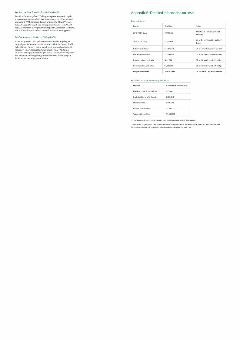
Appendix B: Detailed information on costs
Cost Estimates
Source Total Cost * Notes
2012 VDOT Study $7,886,500Meade St to Fairfax City, mixed
facilities
2014 VDOT Study $7,227,000Glebe Rd to Fairfax City, incl. I-495
Bridge
Bottom-up estimate $17,678,340 DC to Fairfax City, shared-use path
Bottom-up, both sides $22,187,408 DC to Fairfax City, shared-use path
Interim solution, north only $849,294 DC to Fairfax City, no I-495 bridge
Interim solution, both sides $1,586,356 DC to Fairfax City, no I-495 bridge
Integrated estimate $18,353,900 DC to Fairfax City, mixed facilities
Per-Mile Costs for Bottom-up Estimate
Upgrade Cost/mile (in 2014 dollars) *
Bi ke la ne / sha re d l ane ma rk in g $15 ,000
P ro te ct ed b ike l an e ( cy cl et ra ck ) $ 20 0, 00 0
Shared use path $500,000
Bike/pedestrian bridge $7,900,000
Widen bridge by 3 feet $9,504,000
Source: Regional Transportation Priorities Plan, I-66 Multimodal Study 2012 Appendix
* Costs on this page are hard costs associated with actually building infrastructure. In the text of this document, we have
factored in estimated soft costs for for planning, design and other contingencies.
8/10/2019 Arlington Boulevard Trail Concept Plan
http://slidepdf.com/reader/full/arlington-boulevard-trail-concept-plan 23/25
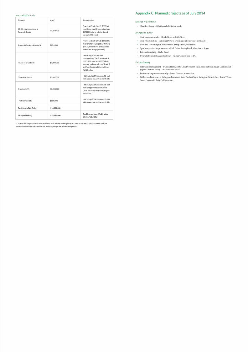
Integrated Estimate
Segment Cost* Source/Notes
23rd St NW to west end of
Roosevelt Bridge$5,873,400
From I-66 Study (2012): $600/sqft
to widen bridge (3’ for .6 miles) plus
$570,000/mile to rebuild shared-
use path (1584 feet)
Ro osev el t Bri dg e t o M ea de St $70 4, 000
From I-66 Study (2012): $570,000/
mile for shared-use path (580 feet),
$7,971,000/mile for 14-foot wide
shared-use bridge (425 feet)
Meade St to Glebe Rd $1,000,000
I-66 Study (2012) for trail
upgrades from Taft St to Meade St
($377,500) plus $420,000/mile forlane and trail upgrades on Meade St
and from Pershing Drive to Glebe
Rd (1.5 miles)
Glebe Rd to I-495 $3,062,000I-66 Study (2014) assumes 10-foot
wide shared use path on north side.
Crossing I-495 $3,300,000
I-66 Study (2014) assumes 16-foot
wide bridge over Fairview Park
Drive and I-495 north of Arlington
Boulevard
I-495 to Pickett Rd $865,000I-66 Study (2014) assumes 10-foot
wide shared use path on north side
Total (North Side Only) $14,804,400
Total (Both Sides) $18,353,900Doubles cost from Washington
Blvd to Pickett Rd
* Costs on this page are hard costs associated with actually building infrastructure. In the text of this document, we have
factored in estimated soft costs for for planning, design and other contingencies.
Appendix C: Planned projects as of July 2014
District of Columbia
» Teodore Roosevelt Bridge rehabilitation study
Arl ingt on C ount y
» rail extension study – Meade Street to Role Street
» rail rehabilitation – Pershing Drive to Washington Boulevard (north side)
» New trail – Washington Boulevard to Irving Street (south side)
» Spot intersection improvements – Park Drive, Irving Road, Manchester Street
» Intersection study – Glebe Road
» Upgrade to limited access highway – Fairax County line to DC
Fairfax County
» Sidewalk improvements – Patrick Henry Dr to Olin Dr (south side), areas between Seven Corners and
Jaguar rl (both sides), I-495 to Pickett Road
» Pedestrian improvements study – Seven Corners intersection
» Widen road to 6 lanes – Arlington Boulevard rom Fairax City to Arlington County line, Route 7 rom
Seven Corners to Bailey’s Crossroads
8/10/2019 Arlington Boulevard Trail Concept Plan
http://slidepdf.com/reader/full/arlington-boulevard-trail-concept-plan 24/25
is project was made possible by a
generous grant from
References
Maps are courtesy of Google and Open Street Map, © 2014
Street cross-sections courtesy of Streetmix.net (see http://streetmix.net/-/146830)
“A Walk on the Wild Side” – Mary Battiata / Washington Post – January 2004
Arlington Master Transportation Plan – Bicycle Element –July 2008
Bicycle and Pedestrian Plan for the National Capital Region – National Capital Region Transportation Plan-
ning Board – October 2010
Captial Bikeshare Member Survey Report – May 2013
e External Damage Cost of Noise Emitted from Motor Vehicles – Mark Delucchi and Sing-Ling Hsu / Uni-
versity of California Davis – 1998
Fairfax County Bicycle Master Plan – Public Dra Version – June 2014
Guide for the Development of Bicycle Facilities – AASHTO – Fourth Edition, 2012
I-66 Multimodal Study – Final Report – VDOT – 2012
I-66 Multimodal Study – Supplemental Report – VDOT – 2014
NOVA Regional Bikeway Study – VDOT – 2003
Regional Transportation Priorities Plan – National Capital Region Transportation Planning Board – January
2014
Nicholls, Sarah and Crompton, John. “e Impact of Greenwa ys on Property Values: Evidence from Austin,
Texas.” Journal of Leisure Research. 2005. 37: 321–341
8/10/2019 Arlington Boulevard Trail Concept Plan
http://slidepdf.com/reader/full/arlington-boulevard-trail-concept-plan 25/25
WASHINGTON
AREA
BICYCLIST
ASSOCIATION waba.org