Embed Size (px)
Citation preview
Arkansas Water Resources Center Annual Technical Report
FY 2002
IntroductionStatewide Mission: The Arkansas Water Resources Center (AWRC) has a statewide mission to plan andconduct water resource research. AWRC cooperates closely with colleges, universities, and otherorganizations in Arkansas to address the state’s water and land-related problems, promote thedissemination and application of research results, and provide for the training of scientists in waterresources. AWRC has contributed substantially to Arkansas water resources via research and training ofstudents. In a typical year, AWRC interfaces with about 25 researchers throughout the state withinvolvement in about 50 projects per year. On average these projects involve training of about 50 studentsmade up of 15 undergraduates, 25 masters, and 10 Ph.D. candidates.
Support Provided: The Center acts as a liaison between funding groups and the scientists, and thencoordinates and administers grants once they are funded. Accounting, reporting, and water analyses aremajor areas of support offered to principal investigators.
Technology Transfer: AWRC sponsors an annual water conference held in Fayetteville-Arkansas eachspring, drawing in about 125 researchers, students, agency personnel, and interested citizens to hear aboutresults of current research and hot topics in water resources throughout the state. AWRC also co-sponsorsshort courses and other water related conferences in the state and region. In addition, AWRC maintains atechnical library containing over 900 titles, many of which are on-line. This valuable resource is utilizedby a variety of user groups including researchers, regulators, planners, lawyers, and citizens.
AWRC Water Quality Laboratory: The Center maintains a modern water quality laboratory that provideswater analyses for researchers, and for farmers and others who submit samples through the CooperativeExtension Service and the Department of Housing and Urban Development.
Geographical Information System (GIS) Support. The Center for Advanced Spatial Technology (CAST)and the GIS Laboratory in the Department of Crop, Soil, and Environmental Sciences provide support indeveloping GIS data for the management and protection of water.
Research ProgramThrough the years, projects facilitated by the Arkansas Water Resources Center have included irrigation,ground water modeling, non-point source pollution, quality of ground water and surface water, efficientseptic tank design, and ecosystem assessment. These projects have been funded by a variety of federal,state, local, and tribal sources. The three research projects funded through the USGS 104 B programduring FY 2002 were focused on point and non-point source nutrient loading of surface streams andreservoirs in northwest Arkansas, identifying and evaluating the viability of alternate water supplies usingabandoned, flooded coal mines for the City of Greenwood, Arkansas, and assessment of variation in waterchemistry in the alluvial aquifer in eastern Arkansas. These applied projects provide invaluable scientificdata on which real-world decisions are based, including decisions about water supply expansion

alternatives, implementation of appropriate and effective nutrient abatement best management strategies,and the development and implementation of groundwater planning and management strategies withinArkansas. A synopsis of the purpose, objectives and results of the three projects funded in FY 2002 areincluded below.
Phosphorus Concentrations and Sediment Phosphorus Flux inStreams and Reservoirs: Effect of Chemical Amendments
Basic Information
Title:Phosphorus Concentrations and Sediment Phosphorus Flux in Streams andReservoirs: Effect of Chemical Amendments
Project Number: 2002AR5B
Start Date: 3/1/2002
End Date: 12/31/2003
Funding Source: 104B
Congressional District:
Third
Research Category: Not Applicable
Focus Category: Water Quality, Sediments, Treatment
Descriptors: Water Quality, Phosphorus, Sediment, Wastewater Treatment Plant
Principal Investigators:
Brian E. Haggard, Indrajeet Chaubey, Marty D. Matlock
Publication
1. Haggard, B.E., M.D. Matlock, I. Chaubey, P.B. DeLaune, and P.A. Moore, Jr. , Stream phosphorusretention in the Illinois River Basin: ecological services and water-quality criteria, ProceedingsReport, Arkansas Water Resources Center Annual Conference, April 2002
2. Haggard, B.E., S.A. Ekka, M.D. Matlock, I. Chuabey, P.B. DeLaune, and P.A. Moore Jr. Release ofphosphorus from stream and reservoir sediments: effect of chemical amendments, ProceedingsReport, Arkansas Water Resources Center Annual Conference, April 2003
3. Ekka, S.A., B.E. Haggard, M.D. Matlock, and I. Chaubey. Impact of wastewater treatment plants instream of the Illinois River Basin, Proceedings Report, American Water Resources AssociationSpring Specialty Conference, May 2003
4. Haggard, B.E., S.A. Ekka, M.D. Matlock, and I. Chaubey. Phosphorus sources in the Illinois RiverBasin: effect of chemical amendments on sediment-phosphorus interactions, Annual Meeting NorthAmerican Benthological Society, May 2003
5. Haggard, B.E., W.R. Green, K.L. White, M.D. Matlock, I. Chuabey, and P.A. Moore, Jr. Phosphorussources in a watershed: phosphorus concentrations and loads at the Illinois River, Arkansas.Phosphorus Management Workshop, Division of Agriculture, University of Arkansas, Fayetteville,Arkansas, October 2002
6. Haggard, B.E., M.D. Matlock, I. Chaubey, and S.A. Ekka. Stream and Sediment Phosphorus

Concentrations in the Illinois River Drainage Area, Northwest Arkansas. Science and TechnologySeminar Series, College of Mathematics and Natural Sciences, Northeastern State University, Tahlequah,Oklahoma, October 2002
Problem and Research Objectives Watershed managers must consider: (1) the effect of wastewater treatment plants on phosphorus concentrations and loads in streams, and (2) the importance of internal P flux from reservoir bottom sediments, when developing watershed management strategies to mitigate water quality problems. The specific objectives of this research are to evaluate stream water P concentration and sediment – P interactions in several Arkansas streams below WWTPs, estimate and compare internal and external P fluxes in the Eucha Basin, and assess the effects of chemical amendments on P flux from stream and reservoir sediments.
Methodology
In spring 2002, water-quality samples were taken from three points along a transect perpendicular to stream flow at each of the 30 sites identified from the Illinois River South of Siloam Springs, Arkansas (U.S. Geological Survey Station No. 07195430) upstream into Mud, Osage and Spring Creeks. Physico-chemical parameters (conductivity and pH) were measured at a single point at each site. Water samples were filtered through a 0.45 µm membrane using a syringe filter unit; 20 ml of filtered water was preserved via acidification using concentrated HCl to pH < 2, and 20 ml of filtered, unacidified water was saved. Filtered water samples were stored on ice and in the dark until return to the laboratory where soluble reactive P (SRP) was determined using an autoanalyzer and the ascorbic acid reduction method. In summer 2002, a single water-quality sample was collected from the center of the channel at each site on Mud, Osage and Spring Creeks including one site upstream and four downstream of the municipal wastewater treatment plant (WWTP) discharge. Physico-chemical parameters (dissolved oxygen, conductivity and pH) were measured at a single point at each site. A portion of the water sample was filtered through a 0.45 µm membrane using a syringe filter unit; 20 ml of filtered water was preserved via acidification using concentrated HCl to pH < 2, and 20 ml of filtered unacidified water was saved. 125 ml of unfiltered water was acidified using concentrated HCl to pH < 2, and another 125 ml of unfiltered, unacidified water was saved. Water samples were stored on ice and in the dark until return to the laboratory where SRP, NO3, NH4, total nitrogen (TN) and Cl- were determined using an autoanalyzer. Beginning in summer 2002, a single sediment sample was collected from one site upstream and three downstream from the municipal WWTP discharge on Mud, Osage and Spring Creek during routine water-quality samplings. The benthic sediments were collected using a trowel from the top 5-10 cm of the streambed, and sediment samples were stored on ice and in the dark until return to the laboratory. Upon return to the laboratory, sediments were sieved through a 4.75 mm sieve and the fraction of sediments < 4.75 mm in diameter were used in subsequent extractions. Sediments were extracted for exchangeable NH4 and PO4 as described in the proposal, and the sediment equilibrium P concentration (EPC0) was determined as described in the proposal. The ability of the sediments to buffer increasing P concentrations and loads was determined by the slope of
the relation between P sorbed and final P concentrations in the EPC extraction sediment slurry solutions (as opposed to the PSI as suggested in the proposal).
Principal Findings and Significance Our initial evaluation of phosphorus concentration and retention in streams of the Illinois River drainage area in Arkansas provided some interesting results. The greatest increase in phosphorus concentrations was observed in Spring Creek just downstream on the City of Springdale’s wastewater treatment plant; the City of Rogers’ and Fayetteville’s wastewater treatment plants had a much smaller impact. Phosphorus retention was generally least in streams with greater flows. A significant result of our investigations was that the addition of aluminum sulfate and calcium carbonate affected stream sediment-phosphorus interactions. Specifically, the chemical amendments reduced the amount of exchangeable phosphorus and equilibrium phosphorus concentration of the stream sediments while increasing the ability of the stream sediments to buffer increasing phosphorus loads.
Chemical Variation of Water From The Alluvial Aquifer
Basic Information
Title: Chemical Variation of Water From The Alluvial Aquifer
Project Number: 2002AR11B
Start Date: 3/1/2002
End Date: 12/31/2003
Funding Source: 104B
Congressional District:
Third
Research Category: Not Applicable
Focus Category: Hydrogeochemistry, Water Quality, None
Descriptors:Variation of ground water chemistry, mixing of ground waters, geochemicalevolution of ground water
Principal Investigators:
Kenneth F. Steele
Publication
1. Steele, K. F., Davis, R.K, and Kresse, T.M., in press. Spatial and temporal nitrate concentrationvariability within the Mississippi River Valley alluvial aquifer on a small scale at selected Arkansas,USA Sites, in Proceedings of the 7th International Specialized Conference on Diffuse Pollution andBasin Management, University College Dublin.
2. Steele, K. F., Davis, R.K, and Kresse, T.M., in press. Small-scale spatial variation of water qualitywithin the Mississippi River Valley alluvial aquifer, Arkansas, USA in 4th Joint IH-CNC/CGSGroundwater Specialty Conference, Winnipeg, Manitoba, Canada, Conference Proceedings.
Problem and Research Objectives Many studies of the alluvial aquifer have noted spatial variability of ground-water chemistry on regional or county scale. These data have often been represented on contour maps of specific conductance, chloride and other ions. Until this project, there had been no studies of small-scale spatial and temporal variability of the alluvial aquifer water chemistry in Arkansas. In order to compare water quality among aquifers, it is critical to determine the density of the wells necessary to represent the aquifers and to establish meaningful contour intervals for parameter values. The impact of season also must be determined so that appropriate sample collection dates and frequency may be selected. Furthermore, there have been comparisons of water quality between shallow and deep wells, but this has rarely been done on small-scale.
The objective of this project was to ascertain the spatial and temporal variability of ground-water chemistry from the alluvial aquifer, Arkansas on a small-scale.
Methodology Wells at three sites in three counties in eastern Arkansas were used in this project. The distribution of the wells used in this study are as follows: (1) three monitoring wells and three irrigation wells at a site in Monroe County, (2) three monitoring wells, a domestic well and three irrigation wells at a Pulaski County site, and (3) four monitoring wells and a domestic well at the Woodruff County site. Samples were collected for the shallow wells at Monroe and Pulaski Counties on June 25 and 26, 2002 and the shallow wells and the nearby deep irrigation wells were sampled on August 11 and 12, 2002. There were existing data for the Woodruff county site from a June 18, 1996 collection date. There were also an additional 8-10 additional historical analyses for nitrate concentrations at the Monroe and Pulaski County sites. The samples collected in 2002 and the historical nitrate collection dates were classed as either recharge (e.g., June samples) or non-recharge (e.g., August samples) conditions in order to determine the impact of recharge conditions (season) on the water chemistry. The ground-water samples were collected and analyzed under standard methodology and quality assurance procedures. The AWRC Water Quality Laboratory performed all of the analyses except for the samples from Woodruff County, which were analyzed by the Arkansas Department of Environmental Quality.
Principal Findings and Significance Because there are differences in the chemical processes affecting the major ions and nitrate, nitrate will be discussed separately. Shallow wells exhibited significant spatial variation for Ca, Mg, Na, HCO3, Cl, and SO4. These ions have maximum concentrations 1.4 to 6.8 times the minimum concentration for shallow wells. Some temporal variation occurs for shallow wells at one site, the maximum to minimum concentration ratios range from 1.3 to 4.7. Deep wells have ion concentrations similar to shallow wells, but generally, the ions have smaller concentration ranges. Heterogeneous mineral and organic carbon abundances, and variable residence times, which affect amount of mineral dissolution and cation exchange, have a major impact on the water chemistry. These factors are the result of discontinuous sedimentary units with variable thickness and extent that affect ground-water movement. Other factors affecting the water chemistry are recharge conditions and fluctuating water table depths that change ground-water flow directions, and that allow de-watering of saturated fine-grained sedimentary units when the water table is declining. There is significant spatial and temporal variability of nitrate. Spatial variability is as great as 0.04 to 14.45 mg/L NO3-N, and temporal (45 days) variability in a well is as great as 0.11 to 14.45 mg/L NO3-N. Deeper wells generally have low nitrate concentrations. The variation of nitrate concentrations can be explained by transport of nitrate from fertilizer to the ground-water system and subsequent denitrification within the alluvial aquifer.
Processes And Controls Affecting Water/Rock Interaction inAbandoned Underground Coal Mines, Including Feasibility andRisk Assessment of Using Mine Water for Public DrinkingWater Sources
Basic Information
Title:Processes And Controls Affecting Water/Rock Interaction in AbandonedUnderground Coal Mines, Including Feasibility and Risk Assessment of Using MineWater for Public Drinking Water Sources
Project Number: 2002AR13B
Start Date: 3/1/2002
End Date: 12/31/2003
Funding Source: 104B
Congressional District:
Third
Research Category:
Not Applicable
Focus Category: Groundwater, Water Quality, Hydrogeochemistry
Descriptors:Water Chemistry, Water-Quality Modeling, Water Resources Development, WaterTreatment, Surface-Groundwater Relations, Health Effects, Heavy Metals
Principal Investigators:
J. Van Brahana
Publication
1. Varnell, C.J., 2004, The Environmental Dynamics of Utilizing Water from Flooded Coal Mines inGreenwood, Arkansas, as a Supplemental Public Drinking Supply -- Physical, Chemical,Social,Political, Economic, and Public Perception Considerations: Ph.D. dissertation, Program ofEnvironmental Dynamics, University of Arkansas, Fayetteville, Arkansas, 169 p. [in preparation]
2. Cooper, K.W., 2003, Processes and Controls Affecting Water Quality in Flooded Coal Mines in theArkansas River Valley: M.S. thesis, Department of Geosciences, University of Arkansas,Fayetteville, Arkansas, 88 p. [in review].
3. Walker, K., C. Varnell, and J.V. Brahana, 2002, Processes and Controls Affecting Water QualityWater Supplies to Meet Our Growing Needs--Scientific, Regulatory, and Public Perspectives,University of Arkansas, Fayetteville, Arkansas.
4. Varnell, C. and J.V. Brahana, 2003, Factors Affecting Water Quality and Surface Water/Ground

Water Interaction Associated with Flooded Coal Mines in Greenwood, Arkansas, University ofArkansas, Fayetteville, Arkansas.
5. Brahana, J.V., 2003, Hydrogeologic Research Along a Transect from the Ozarks to the Quachitas,Northwest to West-Central Arkansas: Field guide for University of Arkansas’ 2003 Field Trip, 66 p.
Problem and Research Objectives Like many small but growing municipalities in west-central Arkansas and the eastern U.S., the city of Greenwood, Arkansas, draws its water from a surface-water source (Vache Grasse Creek, tributary to the Arkansas River). Small streams such as the Vache Grasse are not adequate to provide for the increasing public water-supply needs of the city during periods of low flow or drought. Underlying Greenwood are abandoned coal mines that have been flooded. The mines include both surface pits and underground workings. Based on estimated volumes of void space computed from old mine maps, the voids represent a huge potential reservoir of water that could be used to augment the water needs of the city if the quality is good. Obvious questions about water chemistry caused by withdrawing water from the mines have thwarted previous efforts to assess the feasibility of developing this resource. Inasmuch as abandoned, flooded mines are widespread throughout west-central Arkansas, the Appalacians, the midcontinent U.S., and other scattered areas throughout the country, with limited water supplies, developing an accurate means to cost-effectively evaluate these mines as potential water supplies would provide a valuable tool to local agencies seeking additional water supplies. This study addresses those questions.
Research objectives include characterization of existing water quality, delineation of the active flow system, development of a conceptual model of flow and transport, and compilation of historical documentation of drinking water use from coal mines elsewhere. The study also addresses flow modeling, and geochemical models of water/rock interaction.
Methodology The study is based on field data collection, water quality sampling, water-level measurements, precipitation measurements, pumping tests, field reconnaissance, historical data compilation, lab testing, and modeling. Field and lab analyses have assessed major constituents, minor constituents, trace metals, microbial pathogens, nutrients, organics, color, and other relevant EPA drinking water requirements. Water levels at key components of the hydrogeologic system have been monitored continuously using transducers, floats, and analog strip-chart recorders, and a tipping bucket rain gage has provided a continuous record of precipitation recharge. By comparing response to hydrologic events, both magnitudes and lag times, the degree of interaction between the surface and ground water parts of the system have been documented. Field reconnaissance and historical records have been compiled, and a conceptual model serves as the basis of flow models which are presently being tested.
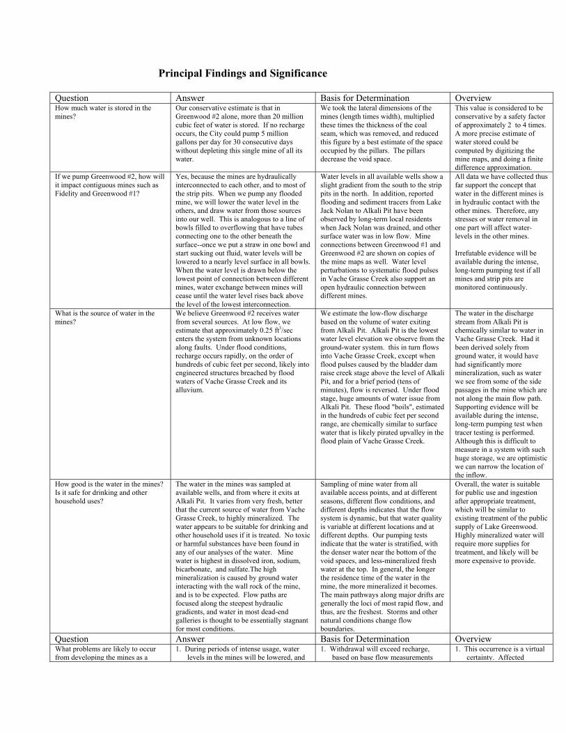
Principal Findings and Significance
Question Answer Basis for Determination Overview How much water is stored in the mines?
Our conservative estimate is that in Greenwood #2 alone, more than 20 million cubic feet of water is stored. If no recharge occurs, the City could pump 5 million gallons per day for 30 consecutive days without depleting this single mine of all its water.
We took the lateral dimensions of the mines (length times width), multiplied these times the thickness of the coal seam, which was removed, and reduced this figure by a best estimate of the space occupied by the pillars. The pillars decrease the void space.
This value is considered to be conservative by a safety factor of approximately 2 to 4 times. A more precise estimate of water stored could be computed by digitizing the mine maps, and doing a finite difference approximation.
If we pump Greenwood #2, how will it impact contiguous mines such as Fidelity and Greenwood #1?
Yes, because the mines are hydraulically interconnected to each other, and to most of the strip pits. When we pump any flooded mine, we will lower the water level in the others, and draw water from those sources into our well. This is analogous to a line of bowls filled to overflowing that have tubes connecting one to the other beneath the surface--once we put a straw in one bowl and start sucking out fluid, water levels will be lowered to a nearly level surface in all bowls. When the water level is drawn below the lowest point of connection between different mines, water exchange between mines will cease until the water level rises back above the level of the lowest interconnection.
Water levels in all available wells show a slight gradient from the south to the strip pits in the north. In addition, reported flooding and sediment tracers from Lake Jack Nolan to Alkali Pit have been observed by long-term local residents when Jack Nolan was drained, and other surface water was in low flow. Mine connections between Greenwood #1 and Greenwood #2 are shown on copies of the mine maps as well. Water level perturbations to systematic flood pulses in Vache Grasse Creek also support an open hydraulic connection between different mines.
All data we have collected thus far support the concept that water in the different mines is in hydraulic contact with the other mines. Therefore, any stresses or water removal in one part will affect water-levels in the other mines. Irrefutable evidence will be available during the intense, long-term pumping test if all mines and strip pits are monitored continuously.
What is the source of water in the mines?
We believe Greenwood #2 receives water from several sources. At low flow, we estimate that approximately 0.25 ft3/sec enters the system from unknown locations along faults. Under flood conditions, recharge occurs rapidly, on the order of hundreds of cubic feet per second, likely into engineered structures breached by flood waters of Vache Grasse Creek and its alluvium.
We estimate the low-flow discharge based on the volume of water exiting from Alkali Pit. Alkali Pit is the lowest water level elevation we observe from the ground-water system. this in turn flows into Vache Grasse Creek, except when flood pulses caused by the bladder dam raise creek stage above the level of Alkali Pit, and for a brief period (tens of minutes), flow is reversed. Under flood stage, huge amounts of water issue from Alkali Pit. These flood "boils", estimated in the hundreds of cubic feet per second range, are chemically similar to surface water that is likely pirated upvalley in the flood plain of Vache Grasse Creek.
The water in the discharge stream from Alkali Pit is chemically similar to water in Vache Grasse Creek. Had it been derived solely from ground water, it would have had significantly more mineralization, such as water we see from some of the side passages in the mine which are not along the main flow path. Supporting evidence will be available during the intense, long-term pumping test when tracer testing is performed. Although this is difficult to measure in a system with such huge storage, we are optimistic we can narrow the location of the inflow.
How good is the water in the mines? Is it safe for drinking and other household uses?
The water in the mines was sampled at available wells, and from where it exits at Alkali Pit. It varies from very fresh, better that the current source of water from Vache Grasse Creek, to highly mineralized. The water appears to be suitable for drinking and other household uses if it is treated. No toxic or harmful substances have been found in any of our analyses of the water. Mine water is highest in dissolved iron, sodium, bicarbonate, and sulfate.The high mineralization is caused by ground water interacting with the wall rock of the mine, and is to be expected. Flow paths are focused along the steepest hydraulic gradients, and water in most dead-end galleries is thought to be essentially stagnant for most conditions.
Sampling of mine water from all available access points, and at different seasons, different flow conditions, and different depths indicates that the flow system is dynamic, but that water quality is variable at different locations and at different depths. Our pumping tests indicate that the water is stratified, with the denser water near the bottom of the void spaces, and less-mineralized fresh water at the top. In general, the longer the residence time of the water in the mine, the more mineralized it becomes. The main pathways along major drifts are generally the loci of most rapid flow, and thus, are the freshest. Storms and other natural conditions change flow boundaries.
Overall, the water is suitable for public use and ingestion after appropriate treatment, which will be similar to existing treatment of the public supply of Lake Greenwood. Highly mineralized water will require more supplies for treatment, and likely will be more expensive to provide.
Question Answer Basis for Determination Overview What problems are likely to occur from developing the mines as a
1. During periods of intense usage, water levels in the mines will be lowered, and
1. Withdrawal will exceed recharge, based on base flow measurements
1. This occurrence is a virtual certainty. Affected

source of drinking water? this will dewater the strip pits, and effectively destroy fishing and recreation associated with these surface water bodies "drying up".
2. During periods of intense usage, water
levels in the mines will be lowered, and this will induce recharge from Vache Grasse Creek into Alkali Pit, unless engineered structures are built to control this flow. Vache Grasse Creek currently carries the waste water from the water treatment plant.
3. During periods of intense usage and low
recharge, water levels in the mines will be lowered, and this will remove the buoyant support of the stored water on mine ceilings where overlying rock is relatively thin. Subsidence is likely to occur, with collapse of the overlying roof material into the mine voids near the strip pits.
4. Geochemical effects of mixing waters
from reducing and oxygenated environments, may facilitate additional dissolution and mobilization of undesirable substances that are currently not in the water.
5. Direct recharge in adequate quantities to
replenish the reservoir appears to be a function of stage of Vache Grasse Creek. Drought conditions during the winter months when mine recharge is expected may require installation of ancillary structures to facilitate artificial recharge.
from Alkali Pit. The deficit will be made up by removing water from storage, which will lower water levels in the mines.
2. Direct observation of water reversing flow into Alkali Pit and the mines when the stage in Vache Grasse Creek is higher than those two. Use of mine water will create transient lowering of water levels, favoring inflow to the mine.
3. Risk assessment of subsidence is not
quantified, but remains a real possibility, based on extrapolation of mining conditions elsewhere (Appalachia), on landforms (internally drained depressions) along the outcrop line, and loss of a bulldozer during construction projects.
4. Empirical evidence indicates that both
water types exist in the mines, but under current conditions there are few transient stresses to favor removal of the reduced water. During pumping, the water will be removed from storage, and during recharge from flood events, it will be replaced with oxygenated water.
5. Historically, mine flooding was the
result of infrequent high flood stages in Vache Grasse Creek.
Annual flow in Vache Grasse is in excess of the anticipated water use from the mines.
landowners will have valid grievances.
2. Hydraulic gradients
favoring flow is a virtual certainty, and engineering alternatives will need to be emplaced to prevent unacceptable water from entering the mine reservoir.
3. We have not been able to
estimate the probability of subsidence, nor assess the conditions necessary to assign high risk. Historically, collapse has not been a common event elsewhere, but the result of a unique combination of conditions. We strongly encourage ongoing monitoring in response to major withdrawals of water.
4. Water chemistry will
change, although we have not seen evidence that it will deteriorate. We strongly encourage ongoing monitoring in response to major pumping tests. It is likely that mine water will initially require more treatment than water from the surface.
5. Engineering alternatives are
available to direct recharge to the mines when natural processes fail to do so
What benefits to the City of Greenwood are likely to occur from developing the mines as a source of drinking water?
1. Significant cost savings. 2. Minimal impact on existing land use and
infrastructure. 3. Shorter completion date for project. 4. PR benefits as a leader in developing new
technology in concert with a broad range of stakeholders.
1. Mines already exist; damming and dredging would require major construction costs.
2. Most land overlying the mines could continue to be used in its present designation; surface impoundment would require abandonment.
3. The storage reservoir is already in place; intake, piping, and engineering structures mentioned earlier are the only new infrastructure required.
4. The methodology has the potential for much wider use; close monitoring assures full support from stakeholders.
1. Savings are estimated to exceed tens of millions of dollars.
2. This option optimizes effective use of space and resources.
3. Physical aspects could
potentially be placed in service next year.
4. Resource allocation
typically is adversarial; there are numerous benefits from this project.

Information Transfer ProgramAWRC sponsors an annual water conference held in Fayetteville each spring, drawing in about 125researchers, students, agency personnel, and interested citizens to hear about results of current researchand hot topics in water resources throughout the state. AWRC also co-sponsors short courses and otherwater related conferences in the state and region. This year’s conference was entitled "Adequate QualityWater Supplies to Meet Our Competing Needs: Scientific, Regulatory and Public Perspectives" andfeatured ninteen oral presentations and eleven posters during the one and one half day conference.
In addition, AWRC maintains a technical library containing over 900 titles, many of which are on-line.This valuable resource is utilized by a variety of user groups including researchers, regulators, planners,lawyers, and citizens. We have recently started converting many of our library holdings to electronic pdfformat which can be accessed via our WEB site at http://www.uark.edu/depts/awrc. Just follow the link toelectronic publications. We are slowly adding archived documents from our library to this electronic dataset, and all new titles are added as we receive them.
AWRC also facilitated two workshops on urban storm water over the past year. These workshops werepresented by Dr. Findlay Edwards, Civil Engineering at the University of Arkansas. There was significantinterest in these workshops from the regulated community because of the pending new regulations that arestarting to impact smaller cities with storm water permitting and monitoring requirements.
Adequate Quality Water Supplies to Meet Our Growing Needs:Scientific, Regulatory and Public Perspectives
Basic Information
Title:Adequate Quality Water Supplies to Meet Our Growing Needs: Scientific,Regulatory and Public Perspectives
Project Number: 2002AR19B
Start Date: 3/1/2002
End Date: 2/28/2003
Funding Source: 104B
Congressional District:
third
Research Category: Not Applicable
Focus Category: Water Quality, Water Supply, Water Use
Descriptors: Arkansas Water Resources Center Annual Conference
Principal Investigators:
Ralph K Davis
Publication
1. Davis, R.K., In Review, Adequate Water Supplies to Meet Our Growing Needs: Scientific,Regulatory and Public Perspectives. Proceedings of the Arkansas Water Resources Center AnnualConference. University of Arkansas, Center for Continuing Education, Fayetteville, Arkansas, April23 and 24, 2002
Adequate Quality Water Supplies to Meet our Growing Needs
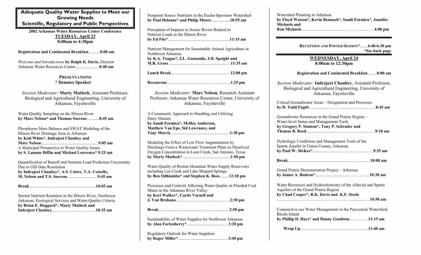
Scientific, Regulatory and Public Perspectives 2002 Arkansas Water Resources Center Conference
TUESDAY, April 23 8:00am to 4:30pm
Registration and Continental Breakfast...........8:00 am Welcome and Introductions by Ralph K. Davis, Director Arkansas Water Resources Center.......................8:40 am
PRESENTATIONS * Denotes Speaker
Session Moderator: Marty Matlock, Assistant Professor,
Biological and Agricultural Engineering, University of Arkansas, Fayetteville
Water Quality Sampling on the Illinois River by Marc Nelson* and Thomas Soerens............8:45 am Phosphorus Mass Balance and SWAT Modeling of the Illinois River Drainage Area in Arkansas by Kati White*, Indrajeet Chaubey and Marc Nelson.......................................................9:05 am A Municipal Perspective to Water Quality Issues by S. Luanne Diffin and Michael Lawrence*.9:25 am Quantification of Runoff and Nutrient Load Prediction Uncertainty Due to GIS Data Resolution by Indrajeet Chaubey*, A.S. Cotter, T.A. Costello, M. Nelson and T.S. Soerens.............................9:45 am Break......................... ......................................10:05 am Stream Nutrient Retention in the Illinois River, Northwest Arkansas: Ecological Services and Water-Quality Criteria by Brian E. Haggard*, Marty Matlock and Indrajeet Chaubey..........................................10:35 am
Nonpoint Source Nutrients in the Eucha-Spavinaw Watershed by Paul Delaune* and Philip Moore..................10:55 am Perception of Impacts to Scenic Rivers Related to Nutrient Loads in the Illinois River by Ed Fite*...........................................................11:15 am Nutrient Management for Sustainable Animal Agriculture in Northwest Arkansas by K.A. Teague*, J.L. Gunsaulis, J.D. Speight and M.R. Gross........................................................…11:35 am Lunch Break.....................................................…12:00 pm
Reconvene.........................................…................1:25 pm
Session Moderator: Marc Nelson, Research Assistant Professor, Arkansas Water Resources Center, University of
Arkansas, Fayetteville A Community Approach to Handling and Utilizing Dairy Manure by Sandi Formica*, McRee Anderson, Matthew Van Eps, Sid Lowrance, and Tony Morris.........................................................1:30 pm Modeling the Effect of Low Flow Augmentation by Discharge From a Wastewater Treatment Plant on Dissolved Oxygen Concentration in Leon Creek, San Antonio, Texas by Marty Matlock*..............................................1:50 pm Water Quality of Boston Mountain Water Supply Reservoirs including Lee Creek and Lake Shepard Springs by Ben Odhiambo* and Stephen K. Boss.........12:10 pm Processes and Controls Affecting Water Quality in Flooded Coal Mines in the Arkansas River Valley by Keri Walker*, Curtis Varnell and J. Van Brahana...........…….................................2:30 pm Break.......................................….........................2:50 pm Sustainability of Water Supplies for Northwest Arkansas by Alan Fortenberry*....................................…3:20 pm Regulatory Outlook for Water Suppliers by Roger Miller*............................................…3:40 pm
Watershed Planning in Arkansas by Floyd Watson*, Kevin Bennoch*, Sandi Formica*, Jennifer Michaels and Ron Michaels.........................................………….....……4:00 pm
RECEPTION AND POSTER SESSION*.......4:40-6:30 pm
*See back page
WEDNESDAY, April 24 8:00am to 12:30pm
Registration and Continental Breakfast...…..8:00 am
Session Moderator: Indrajeet Chaubey, Assistant Professor,
Biological and Agricultural Engineering, University of Arkansas, Fayetteville
Critical Groundwater Areas – Designation and Processes by D. Todd Fugitt.......................………....…….........……8:45 am Groundwater Resources in the Grand Prairie Region – Water-level Status and Management Tools by Gregory P. Stanton*, Tony P. Schrader and Thomas B. Reed..............................……………........……9:10 am Hydrologic Conditions and Management Tools of the Sparta Aquifer in Union County, Arkansas by Paul W. McKee*................................………........…..9:35 am Break..........................................................…….......…..10:00 am Grand Prairie Demonstration Project – Arkansas by James A. Bodron*................................…………....10:30 am Water Resources and Hydrochemistry of the Alluvial and Sparta Aquifers of the Grand Prairie Region by Chad Cooper*, R.K. Davis and K.F. Steele …………………………..……………….…..............…10:50 am Conjunctive-use Water Management in the Pawcatuck Watershed, Rhode Island by Phillip D. Hays* and Danny Goodwin....………..11:15 am
Wrap Up..................................................…….......11:40 am
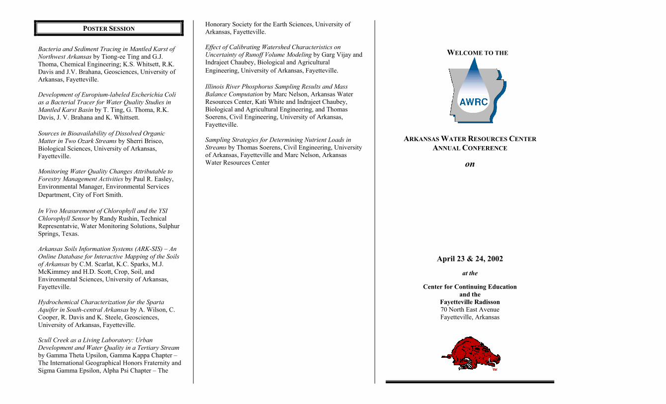
POSTER SESSION
Bacteria and Sediment Tracing in Mantled Karst of Northwest Arkansas by Tiong-ee Ting and G.J. Thoma, Chemical Engineering; K.S. Whitsett, R.K. Davis and J.V. Brahana, Geosciences, University of Arkansas, Fayetteville. Development of Europium-labeled Escherichia Coli as a Bacterial Tracer for Water Quality Studies in Mantled Karst Basin by T. Ting, G. Thoma, R.K. Davis, J. V. Brahana and K. Whittsett. Sources in Bioavailability of Dissolved Organic Matter in Two Ozark Streams by Sherri Brisco, Biological Sciences, University of Arkansas, Fayetteville. Monitoring Water Quality Changes Attributable to Forestry Management Activities by Paul R. Easley, Environmental Manager, Environmental Services Department, City of Fort Smith. In Vivo Measurement of Chlorophyll and the YSI Chlorophyll Sensor by Randy Rushin, Technical Representatvie, Water Monitoring Solutions, Sulphur Springs, Texas. Arkansas Soils Information Systems (ARK-SIS) – An Online Database for Interactive Mapping of the Soils of Arkansas by C.M. Scarlat, K.C. Sparks, M.J. McKimmey and H.D. Scott, Crop, Soil, and Environmental Sciences, University of Arkansas, Fayetteville. Hydrochemical Characterization for the Sparta Aquifer in South-central Arkansas by A. Wilson, C. Cooper, R. Davis and K. Steele, Geosciences, University of Arkansas, Fayetteville. Scull Creek as a Living Laboratory: Urban Development and Water Quality in a Tertiary Stream by Gamma Theta Upsilon, Gamma Kappa Chapter – The International Geographical Honors Fraternity and Sigma Gamma Epsilon, Alpha Psi Chapter – The
Honorary Society for the Earth Sciences, University of Arkansas, Fayetteville. Effect of Calibrating Watershed Characteristics on Uncertainty of Runoff Volume Modeling by Garg Vijay and Indrajeet Chaubey, Biological and Agricultural Engineering, University of Arkansas, Fayetteville. Illinois River Phosphorus Sampling Results and Mass Balance Computation by Marc Nelson, Arkansas Water Resources Center, Kati White and Indrajeet Chaubey, Biological and Agricultural Engineering, and Thomas Soerens, Civil Engineering, University of Arkansas, Fayetteville. Sampling Strategies for Determining Nutrient Loads in Streams by Thomas Soerens, Civil Engineering, University of Arkansas, Fayetteville and Marc Nelson, Arkansas Water Resources Center
WELCOME TO THE
ARKANSAS WATER RESOURCES CENTER ANNUAL CONFERENCE
on
April 23 & 24, 2002
at the
Center for Continuing Education and the
Fayetteville Radisson 70 North East Avenue Fayetteville, Arkansas

Student Support
Student Support
CategorySection 104Base Grant
Section 104RCGP Award
NIWR-USGS Internship
Supplemental Awards
Total
Undergraduate 2 0 0 11 13
Masters 3 0 0 20 23
Ph.D. 1 0 0 2 3
Post-Doc. 0 0 0 0 0
Total 6 0 0 33 39
Notable Awards and AchievementsChemical Variation of Water from the Alluvial Aquifer is the first project to describe the extensive spatial,and some temporal, variation of water chemistry for closely spaced wells within the alluvial aquifer,Arkansas.
Baum Teaching Award - University of Arkansas (incorporation of case study of Greenwood into new classfor Environmental Dynamics)
Arkansas Water Resources Center investigators Marc Nelson, Kati White and Thomas Soerens recentlycompiled a phosphorus mass balance for the Illinois River system in northwest Arkansas. These data arecritical input to a Decision Support System being developed for watersheds in northwest Arkansas thathave been impacted by point and nonpoint source contaminants. Contaminant load to the Illinois Riverwas estimated to be 43 percent from point sources (municipal effluent) and 57% from nonpoint sources(animal manures, poultry litter, commercial fertilizer, and natural sources) within the watershed. Thesedata are important because excessive phosphorus has resulted in eutrophic conditions in impoundments onthe Illinois and other rivers in region. The Illinois flows west into Oklahoma where a new phosphorusstandard of 0.37 mg/L has been proposed. Based on the mass balance estimations prepared by Nelson andothers it is clear that this limit is being exceeded during base flow conditions due in large part to the pointsources within the watershed, and during storm pulses due primarily to the nonpoint source contribution.Basing planning and management decisions on quality data is the key to successfully reducing impacts ofeutrophication in this and other watersheds throughout the Ozarks.
Digital county soils maps are available for about 60 of Arkansas 75 counties as a result of coordinationwith UA Center for Advanced Spatial Technologies, UA Soil Physics Laboratory and the Arkansas Soiland Water Conservation Commission
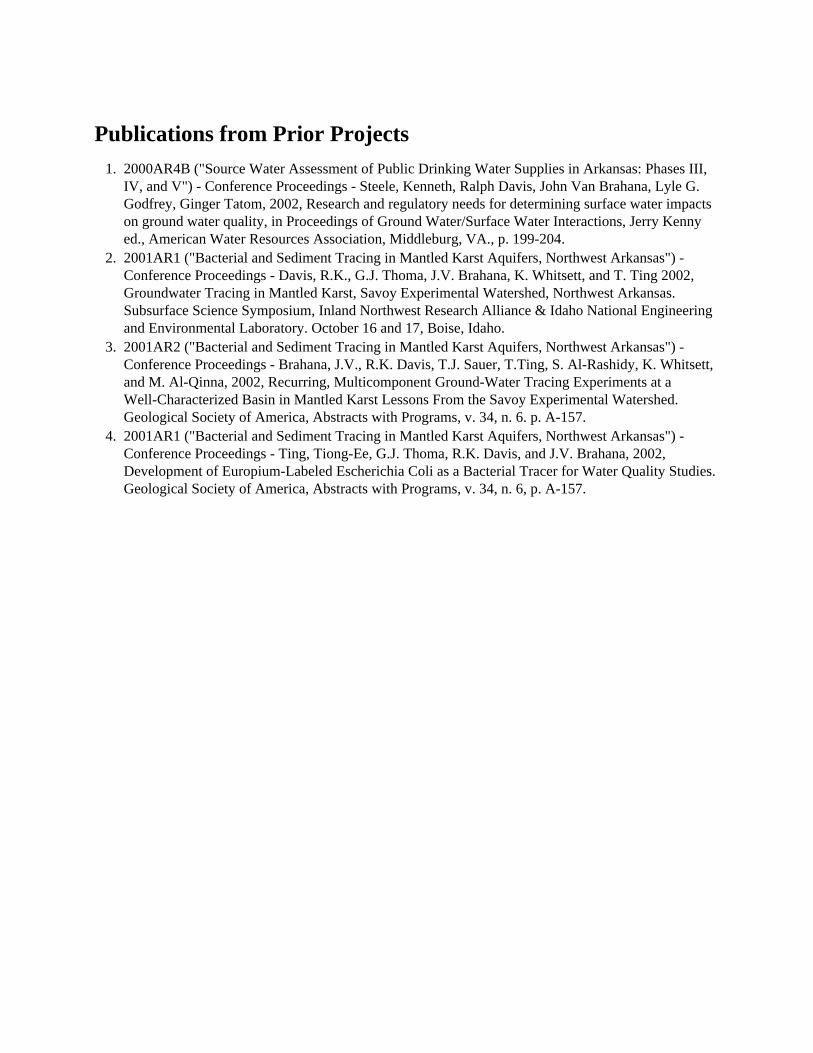
Publications from Prior Projects1. 2000AR4B ("Source Water Assessment of Public Drinking Water Supplies in Arkansas: Phases III,
IV, and V") - Conference Proceedings - Steele, Kenneth, Ralph Davis, John Van Brahana, Lyle G.Godfrey, Ginger Tatom, 2002, Research and regulatory needs for determining surface water impactson ground water quality, in Proceedings of Ground Water/Surface Water Interactions, Jerry Kennyed., American Water Resources Association, Middleburg, VA., p. 199-204.
2. 2001AR1 ("Bacterial and Sediment Tracing in Mantled Karst Aquifers, Northwest Arkansas") -Conference Proceedings - Davis, R.K., G.J. Thoma, J.V. Brahana, K. Whitsett, and T. Ting 2002,Groundwater Tracing in Mantled Karst, Savoy Experimental Watershed, Northwest Arkansas.Subsurface Science Symposium, Inland Northwest Research Alliance & Idaho National Engineeringand Environmental Laboratory. October 16 and 17, Boise, Idaho.
3. 2001AR2 ("Bacterial and Sediment Tracing in Mantled Karst Aquifers, Northwest Arkansas") -Conference Proceedings - Brahana, J.V., R.K. Davis, T.J. Sauer, T.Ting, S. Al-Rashidy, K. Whitsett,and M. Al-Qinna, 2002, Recurring, Multicomponent Ground-Water Tracing Experiments at aWell-Characterized Basin in Mantled Karst Lessons From the Savoy Experimental Watershed.Geological Society of America, Abstracts with Programs, v. 34, n. 6. p. A-157.
4. 2001AR1 ("Bacterial and Sediment Tracing in Mantled Karst Aquifers, Northwest Arkansas") -Conference Proceedings - Ting, Tiong-Ee, G.J. Thoma, R.K. Davis, and J.V. Brahana, 2002,Development of Europium-Labeled Escherichia Coli as a Bacterial Tracer for Water Quality Studies.Geological Society of America, Abstracts with Programs, v. 34, n. 6, p. A-157.


![Arkansas Water Resources Center · ling groundwater supplies in the Grand Prairie of eastern Arkansas [U.S. Army Corps of Engineers, n.d.]., where water-intensive rice and soybean](https://img.pdfslide.us/doc/110x75/5f901c7b2c911b10303d9769/arkansas-water-resources-center-ling-groundwater-supplies-in-the-grand-prairie-of.jpg)