Embed Size (px)
Citation preview
92
Workgroup eArgonauts – Restoration of Ancient Inland Waterways to Promote Sustainable Tourism in Borderlands
aBStraCt
The main objective of the project is to restore some of the ancient inland waterways in the Danube River Basin and Adriatic River Basin to help implement a sustainable boat tourism in order to connect societies in borderlands, improve their socio-economic future and consequently help improve water management and the environment of the river basins, reduce cross border water pollution, promote natural heritage and support local organic farming. The project takes into consideration the needs of the incoming tourist, that will come to these areas for boat adventures and fulfil expectations of local communities in borderlands, and the low water table and the ecological perspective, which call for the use of smaller boats with basic facilities. The final outcome of the project will be a spatial plan proposal for local and/or national authorities in study areas.
keYWordS
inland waterways boat tourismnatural heritageorganic farmingwater tablespatial plan proposalenvironmental history
autHorS
DATO Gaetano, from University of Trieste (ITALY)HILL Katalin, from Eötvös Loránd University (HUNGARY)MAVELLI Massimo, from University of Trieste (ITALY)POP Ana-Maria, from „Babes-Bolyai“ University (ROMANIA)TORKAR Gregor, from University of Nova Gorica (SLOVENIA)ZWITTER Žiga, from University of Ljubljana (SLOVENIA)
93projects – workgroup e
1. INTRoDUCTIoN
the Greek mythological hero jason, who is said to be a founder of the city lju-bljana in slovenia, has travelled along with his fellow argonautus on the ship called argo, across the Black sea and up the Danube, sava and ljubljanica rivers all the way to the spring of latter. there the argonauts disassembled their ship to be able to carry it to the adriatic sea, put it together again, and return to Greece. this interesting legend inspired our project that is focusing on restoration of ancient inland waterways on Danube river Basin and adri-atic river Basin. it was also a reason why we chose for the project acronym »argonautus«.
like jason and the argonauts our interdisciplinary and international Dianet group of experts explored the regions between north adriatic and Black sea to find the possibilities to restore ancient inland waterways in order to ensure the socio-economically viable future and environmentally feasible develop-ment of the societies in borderlands that are divided by rivers and political borders.
Project explores the possibilities of developing sustainable boat tourism in borderlands in order to connect societies in borderlands, improve their socio-economic future and consequently help improve water management in the regions in North Adriatic River Basin and Danube River Basin.
in Section 2, we summarize the research problem and objectives of the pro-posed project and emphasize the relevance of the project in the frame of the strategy of Danube river Basin and Horizon 2020. in Section 3 basic back-ground information to the selected case studies is given and problems in the areas are summarized. s.W.o.t. analysis will be presented for each case study that will help us identify possibilities for future sustainable development. Sec-tion 4 details some of the methodological approaches that our international and interdisciplinary group can offer in order to help societies in borderlands. case studies are based around ancient waterways that we intend to use as a drive to promote ecologically, socially and economically balanced devel-opment in the regions. We will present and discus selected problems and challenges within areas of selected case studies. last but not least, Section 5 gives some final remarks.
94
2. RESEARCh PRoBlEM AND oBJECTIvES
neolithic and later settlements were mainly along the rivers. the vicinity of the Danube influenced the development of settlements and the relationship between them. the Danube river was essential; serving as a landmark, bor-der, source of food, but also endangering the sites by a shifting water course (Penezic et al., 2013). nowadays, 19 countries in the Danube river Basin share many common issues; the Danube region is a major international hydrologi-cal basin and ecological corridor. this requires a regional approach to spa-tial planning, nature conservation and water management. Pollution does not respect national borders. Water resources are one of the most important is-sues in the region and need cross-border cooperation. more than 81 million people are interconnected with the water system of Danube river. Danube is one of the most polluted rivers in the world. it absorbs raw sewage from cities, pesticides and fertilizers from agricultural fields, waste from factories and bilge oil from ships. countries in the region also share the issues of in-sufficient resources for socio-economic development, ranging from funds to human resources. the river basin approach is the best way to manage water in Danube and north adriatic river Basins (Water Framework Directive, 2000) where proposed project is implemented.
The main objective of this project is to restore some of the ancient waterways to help implement a sustainable tourism in borderlands. We intend to achieve this objective by implementing sustainable boat adventures named “Argo-nauts: sustainable river adventures”. The chosen case studies are border-lands along the Tisa River (Hungary-Romania) and Mura River (Slovenia-Croa-tia-Hungary) from Danube River Basin and Soča/Isonzo River (Italia-Slovenia) from Adriatic River Basin. These rivers are separating countries, regions, peo-ple and cultures, particularly severely in the times of Iron Curtain.
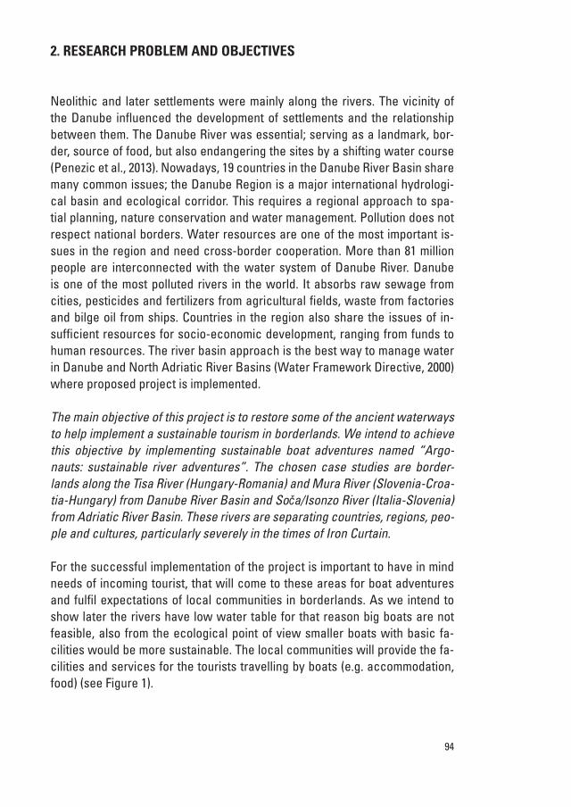
For the successful implementation of the project is important to have in mind needs of incoming tourist, that will come to these areas for boat adventures and fulfil expectations of local communities in borderlands. as we intend to show later the rivers have low water table for that reason big boats are not feasible, also from the ecological point of view smaller boats with basic fa-cilities would be more sustainable. the local communities will provide the fa-cilities and services for the tourists travelling by boats (e.g. accommodation, food) (see Figure 1).
95projects – workgroup e
Figure 1. The scheme represents the needs of tourists travelling by boats, services that local communities must provide to these tourists and expected short/long-term benefits in the bor-derlands from sustainable point of view.
this project is aligned with the strategy of Danube river Basin and Horizon 2020 for several reasons. one of the priority areas in strategy is to connect the Danube region throw implementing new inland waterways and building prosperity in the Danube region. Project contributes to research and innova-tion for greener, smarter and more integrated transport system that will make an important contribution to the europe 2020 goals of smart, sustainable and inclusive growth and the objectives of the innovation union flagship initiative (Horizon 2020). it supports the competitiveness of enterprises and invests in people and skills (e.g. new job opportunities: interpreters, craftsmen, organic farmers…). Project also contributes to the protection of the environment in the Danube region by promoting natural heritage and supporting local organic farming. regional approach to nature conservation, spatial planning and wa-ter management is applied in the project. From the social and cultural point of view proposed project will assist societies in borderlands to improve cross border cooperation. it will help them to build social, economic, cultural and ecological connections and unite them in common vision of sustainable tour-ism based on the sustainable tourist activities around rivers.
Project also contributes to the goals of other relevant transnational pro-grammes and directives. Particularly important is the Water Framework Di-rective where one of the imperative eu actions is environmental improvement of river basins and reducing cross border water pollution. long-term goal of the project is to achieve good ecological and chemical status, to protect hu-man health, water supply, natural ecosystems and biodiversity which is in line with the Directive. Project is also important for promotion and preservation of natura 2000 network of protected areas, consisting of special areas of con-
96
servation established under the eu Habitats Directive and special Protection areas established under the eu Birds Directive. there are several natura 2000 sites within the three case studies. Project also contributes to the efforts of the international commission for the Protection of the Danube river (icPDr) in the fields of sustainable water management and facilitates cooperation be-tween the Danube countries, particularly borderlands surrounding rivers in the case studies.
the final outcome of the project will be a spatial plan proposal for local and/or national authorities in study areas. the plan will include detailed de-scription how to implement sustainable boat tourism on inland waterways in the studied areas. a detailed plan of the tourist development in the border-lands will be developed; considering promotion of important natural and cul-tural heritage, local food production, revival of local crafts, development of tourist facilities, recreational roads for cycling and trekking etc.. the hidden, long term goal of the project is to change unsustainable land use practices in the studied areas and improve water resource management.
3. CASE STUDIES
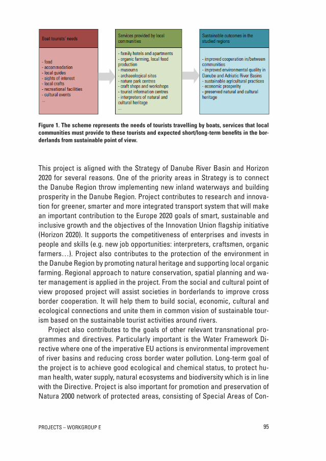
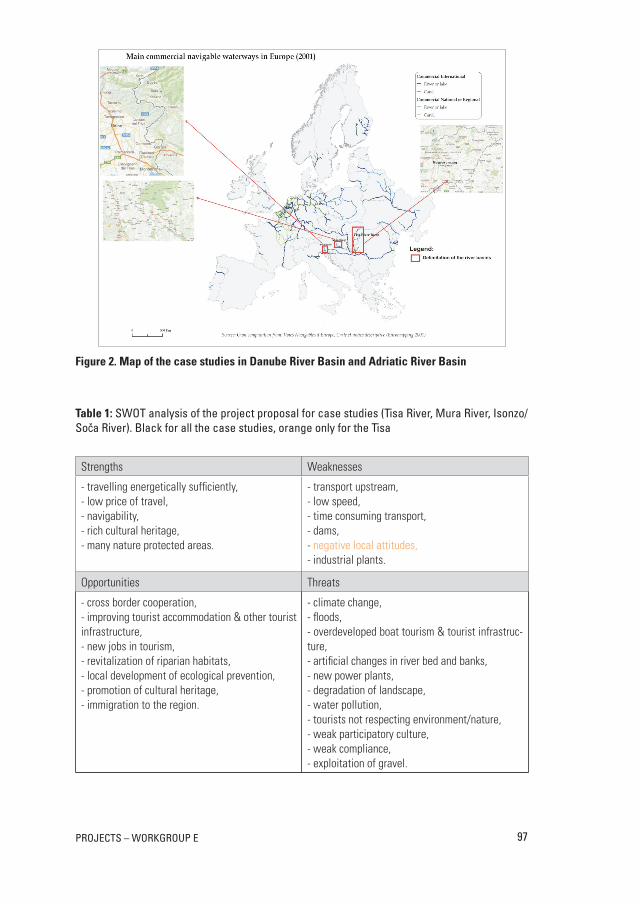
these rivers selected for the case studies are floating throw borderlands; sep-arating countries, regions, people and cultures. in the past these rivers repre-sented both a natural and political division between countries and regions, but since these countries joint european union new possibilities for cross border cooperation occurred. three case studies were selected (Figure 2):
• the Tisa River (Romania-Hungary) – Danube River Basin
• the Mura River (Slovenia-Croatia-Hungary) – Danube River Basin
• Soča/isonzo river (italia-slovenia) – adriatic river Basin.
97projects – workgroup e
Figure 2. Map of the case studies in Danube River Basin and Adriatic River Basin
Table 1: sWot analysis of the project proposal for case studies (tisa river, mura river, isonzo/soča river). Black for all the case studies, orange only for the tisa
Strengths Weaknesses
- travelling energetically sufficiently,- low price of travel,- navigability,- rich cultural heritage,- many nature protected areas.
- transport upstream,- low speed,- time consuming transport,- dams,- negative local attitudes,- industrial plants.
Opportunities Threats
- cross border cooperation,- improving tourist accommodation & other tourist infrastructure,- new jobs in tourism,- revitalization of riparian habitats,- local development of ecological prevention,- promotion of cultural heritage,- immigration to the region.
- climate change, - floods,- overdeveloped boat tourism & tourist infrastruc-ture,- artificial changes in river bed and banks,- new power plants,- degradation of landscape,- water pollution,- tourists not respecting environment/nature, - weak participatory culture,- weak compliance,- exploitation of gravel.
98
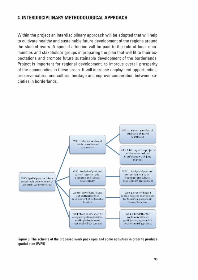
4. INTERDISCIPlINARy METhoDoloGICAl APPRoACh
Within the project an interdisciplinary approach will be adopted that will help to cultivate healthy and sustainable future development of the regions around the studied rivers. a special attention will be paid to the role of local com-munities and stakeholder groups in preparing the plan that will fit to their ex-pectations and promote future sustainable development of the borderlands. Project is important for regional development, to improve overall prosperity of the communities in these areas. it will increase employment opportunities, preserve natural and cultural heritage and improve cooperation between so-cieties in borderlands.
Figure 3. The scheme of the proposed work packages and some activities in order to produce spatial plan (WP5)
7
Figure 3. The scheme of the proposed work packages and some activities in order to produce spatial plan (WP5). Taking into account the sustainable development of the Danube and Adriatic River Basin, by focusing on three case studies regarding the use of the ancient waterways, the most appropriate is interdisciplinary methodological approach that we synthesized into spatial plan (Work package 5). This tool emphasizes all methods used in spatial planning, where dynamic of the territory is included. The main steps of the methodology used, indicators and data, are:
a. Identification of the target area: Danube and North Adriatic River Basin, Tisa River, Mura River, Soča River (Monfalcone-Ljubljana). For each river catchment area, we will overlay administrative units (according to the NUTS system, used by EUROSTAT), different land use categories (according to CORINE LAND COVER), and different delimitation of the river from hydrological point of view.
b. Establishing temporal scale, which will include all political units in order to emphasize administrative aspects, the obstacles imposed by administrative borders, use of waterways, different distribution of settlements or natural and cultural resources.
c. Collection and interpretation of internal drivers. This step will be an interdisciplinary issue, including collection and interpretation of all indicators compulsory for an overall view of the river basins. All important aspects, gathered with the help of different disciplines, will be integrated with GIS methods in order to realise a clear assessment of waterways and their impacts. We identified the following important aspects:
Historical information: written sources and material remains, using old historical maps, old pictures, archives; Statistics and demographic data: population (number of inhabitants, population density, number of employees), settlements (number of settlements);
99projects – workgroup e
in order to support the design of the plan for the case studies the project foresees activities as: – to undertake a historical review of public use of inland waterways; economic,
social, cultural and ecological aspects of waterways (Work package 1)– to undertake an analysis of past and current regional socio-economic and
cultural development in case study areas with particular interest to water resource management and tourism (Work package 2)
– to undertake the study of natural and cultural heritage in case study areas in order to provide the input for development of sustainable tourism (Work package 3)
– to develop and implement new approaches in stakeholder analysis and participation aimed to bridge across environmental and human socio-eco-nomic needs in case study areas and implement sustainable boat tourism (Work package 4)
– to develop a spatial plan for future sustainable development of tourism in case study areas (Work package 5)
taking into account the sustainable development of the Danube and adriatic river Basin, by focusing on three case studies regarding the use of the ancient waterways, the most appropriate is interdisciplinary methodological approach that we synthesized into spatial plan (Work package 5). this tool emphasizes all methods used in spatial planning, where dynamic of the territory is includ-ed. the main steps of the methodology used, indicators and data, are:
a) Identification of the target area: Danube and north adriatic river Basin, tisa river, mura river, soča river (monfalcone-ljubljana). For each river catchment area, we will overlay administrative units (according to the nuts system, used by eurostat), different land use categories (accord-ing to corine lanD coVer), and different delimitation of the river from hydrological point of view.
b) Establishing temporal scale, which will include all political units in order to emphasize administrative aspects, the obstacles imposed by adminis-trative borders, use of waterways, different distribution of settlements or natural and cultural resources.
c) Collection and interpretation of internal drivers. this step will be an inter-disciplinary issue, including collection and interpretation of all indicators compulsory for an overall view of the river basins. all important aspects, gathered with the help of different disciplines, will be integrated with Gis
100
methods in order to realise a clear assessment of waterways and their im-pacts. We identified the following important aspects:– HiStoriCaL inforMation: written sources and material remains, using old
historical maps, old pictures, archives;– StatiStiCS and deMograpHiC data: population (number of inhabitants, popu-
lation density, number of employees), settlements (number of settle-ments);
– HYdrograpHiCaL indiCatorS: water bodies, floods, excess water, reservoirs, and dams;
– SoCio-eConoMiC indiCatorS: smes, main economic activities, cultural re-sources, accommodation utilities, transportation connections, number of pollutants;
– Land uSe CHangeS, according to corine lanD coVer;– naturaL environMent data: natural protected areas (natura 2000, ram-
sar sites, national and natural reserves).
d) Collection and interpretation of external drivers. the project is especially focusing on the existing problems within the river catchment areas, all spa-tial plans or regulations will be integrated, such as land use restrictions, different proposals regarding infrastructure improvement, zoning maps, expected ecological networks, etc.
e) Realisation of possible scenarios regarding future territorial development and visualisation of an integrative interdisciplinary approach. this ap-proach will take into account internal and external drivers, realised in Gis and integrated scenarios can be constructed. the scenarios will allow a comparison of past and current situation in order to have a coherent image of the problems resolved by our project.
WP1.1. Historical reVieW oF PuBlic use oF inlanD WaterWaYs on tHe mura riVer (sloVenia)
paSt uSe of WaterWaYS
Deep understanding of the landscape is inevitable for planning its future de-velopment. the numerous examples of extreme natural events forgotten after a couple of years and the fact that nature changes all the time send us a strong message that carefully studied present situation is just a part of the required knowledge. the study of historical sources based on the understanding of nat-
101projects – workgroup e
ural processes, their impact on human society and the influence of the society on nature, the field of research of environmental history (Hughes 2008, pp. 321, 323, 324) cannot be avoided.
in the uppermost parts of the rivers and on streams in mountainous and hilly landscape floating of wood was a common practice, causing damage to river bed and banks and reducing the fish population (Winiwarter, Knoll 2007, p. 223). Further down the stream wood used to be transported bound in rafts, often loaded with cargo (Braudel 1989, p. 435; Winiwarter, Knoll 2007, p. 222), accompanied by boats. at least since the 13th century many rivers in the Danube river basin like the sava, the ljubljanica, the savinja, the Drava/Drau and the mura/mur to mention just the ones from the surrounding of one of the case studies were navigable (Kosi 1998, p. 151). in the 18th century the existing navigable waterways were extensively prolonged, causing major en-vironmental damage. in order to build and maintain navigable waterways fish spawning places were destroyed, artificial channels used to be built, forest on river banks was cut while arranging and maintaining road for upstream drawing of the boats (reith 2011, p. 29). according to the estimation for the 18th century the ratio of channel to carriage transport was 1 to 3, the data from the 19th century reveal that upstream transport cost five times as much as downstream navigation but still only half as much as the railway and a sixth as much as road transport. For this reason waterways were still important after the railway connections were built (Winiwarter, Knoll 2007, p. 220). capacity was an advantage of river transport (Kosi 1998, p. 149); cargo which could be transported differed tremendously regarding the direction. Data referring to the Danube at regensburg reveal that a ship navigating downstream could be loaded with 2000 cents, whereas the maximum weight of its upstream cargo could be 300-400 cents. From the point of view of sustainability the low energy consumption of river navigation has to be emphasized. according to the well accepted estimation referring to the 18th century 4 kg of cereals were needed to transport 1 ton heavy load 1 km long but not more than 1 kilogram of cereals in case of inland navigation (Winiwarter, Knoll 2007, pp. 217-220).
Downstream navigation was a quick way of transport. it was not excep-tional to travel 100 km per day according to the data for rivers like the salzach and the inn at the turn from the middle ages to the early modern Period (Kosi 1998, p. 150). the velocity was severely influenced by river discharge, water table, wind directions, weather situations, forcing boat to stop, but also by human factors, especially toll stations, dams, gates (Braudel 1989, p. 432) and floating mills (Golec 2009, p. 325). Before regulations the majority of rivers used to be much wider than today with less powerful current and considerable shallow areas, where accumulation took place thus promoting freezing (rohr
102
2007, p. 201). especially in some periods of the little ice age ice covering on rivers was common, preventing navigation and causing damage to harbours. the frequency of occurrence of sharp winters altered according to the climate change, the maunder minimum is one of the periods when data from the me-ridional Balkans and those from the middle europe show their more frequent occurrence (Dobrovolný et al. 2010, pp. 92-93; Xoplaki et al. 2001, pp. 589, 597). the floods in the other periods also caused damage in harbours and wracked the boats. rocks near below the watertable and due to accumulation change-able locations of shallow water were the main hazards (Braudel 1989, p. 432). unlike the downstream velocity the upstream navigation took extremely long, what limited its suitability. according to the sources from the 18th century it usually took 40 horses 29-48 days (depending on weather and watertable) to draw two ships on the Danube from Vienna back to regensburg (Winiwarter, Knoll 2007, p. 218), where boats used to be oxendrawn the way took them even more than one and a half of that time (Kosi 1998, p. 150).
Beside the downstream and upstream transport navigation used to be a way of crossing the river, unless there was a bridge or a ford (cf. Hozjan 2007, p. 200).
CaSe StudY: tHe Mura river
the mura used to play the most important role among rivers in styria from the point of view of traffic, linking the northern and southern part of the province. rock salt, iron and wood from upper styria were transported downstream on boats and rafts. at least from the 1st half of the 13th century passenger traffic is reported. the river used to be navigable from murau downstream. the up-stream horsedrawn river navigation is already recorded in the 2nd half of the 14th century. the radkersburg/radgona city played central role in navigation on the lower mura, river traffic is recognized to be one of the factors con-tributing to the development of the city to a more than regional trade centre in the late middle ages. the monopoly in trade from radgona/radkersburg downstream to Hungarian territory, existing already in the year 1383, was an important source of citizens’ income. Beside the upstream and down-stream transport navigation was also a very common way of river crossing. seven ferries used to exist on the river section between leibnitz/lipnica and the mura east from ljutomer (at ehrenhausen/ernovž, Weitersfeld, mureck/cmurek, Podgorje, Petanjci, Veržej and melinci) but only 2 bridges (at leibnitz/lipnica and radkersburg/radgona) around the year 1400. During the history river changed its direction several times, leading to great changes in land-scape. east from mureck/cmurek in the 15th and the following centuries the
103projects – workgroup e
river channel moved to the north during the floods, causing the abandonment of half a dozen villages and destroying the whole medieval mainroad to rad-kersburg/radgona (Kosi 1998, pp. 157-158, 262 & map enclosed). Due to the accumulated sand and gravel the hazard of stranding was present, especially at low water table and after the flooding events, submerged trunks here and there caused capsizing (Hozjan 2007, p. 198; Petrić 2011, p. 60). the data refer-ring to the near Drava river reveal that the maximal weight of cargo on one boat amounted to 150 to 160 cents, if the cargo might not get wet even less, 100 cents in terms of gunpowder. the boats used to be much bigger in the middle 19th century being possible to carry 300 cents of cargo and 200 cents on rafts (Kolar 2011, pp. 102-103). in the 18th century the extent of artificial interventions to the lower mura was not considerable, only minor works in the 1770s are reported (Šorn 1984, p. 37). HiStoriCaL MetHodS
the historical part of the work is going to be based on critical study of archi-val sources and their published editions. Historical research of the periods when navigable transport used to play an important role is inevitable to avoid the unnecessary mistakes while reintroducing navigable river transport. the retrogressive approach to the analysis of historical maps will be based on the Franciscan cadastre map, georeferenced using the Gis. the result of a careful study of the archival collections of maps presenting the waterworks from the 1780s to the 1890s (Gesamtinventar 1959, pp. 207-208) will be the overlaying of the cadastre maps from the 1820s using Gis. the next step back in time will include an accurate georeferentiation of the maps, drawn for military purpose between the years 1763-1787 in the scale 1:28.800; by paying special attention to more stable landscape features their digitalisation will be possible despite the fact that the working methods were not entirely reliable. the result of the mentioned analysis of the maps will contribute to the understanding of his-torical characteristics of the river channel, influencing the size of historical vessels and assessment of past sustainability. since the aim of the project is to reintroduce small boats and rafts the data from the early modern Period are more important than the ones introduced later. thus the respective sources of the inner austrian court chamber and from the archives of the states of styria (Das landschaftliche archiv) are going to be studied. While the selection of the sources of the states will be based on a modern register, the detailed registers on yearly level (archival sources themselves) will present the basis for the selection of the documents of the inner austrian court chamber. to collect the data for the other bank of the mura river the edition Viri za zgodovino Prekmur-
104
ja/Források a muravidék történetéhez 1, covering the period from 871 to 1849 will be investigated.
additionally historical data on the mura watertable from the years 1808-1836 (archival collection »Kleine archivabteilungen« in the Provincial archives of styria (cf. Gesamtinventar 1959, p. 210)) will be studied and connected with the information on floods and their impact on river traffic from the same period. this investigation of the circumstances during the early 19th century peak of the little ice age will provide a better understanding of possible future im-pacts of the climate change on the reintroduced river navigation, improving the assessment of its sustainability.
WP1.2. HistorY oF tHe Projects oF tHe neVer Built monFalcone-ljuBljana cHannel: isonZo/soČa case stuDY (italY-sloVenia)
this case study focuses on the connection between the Danube river Basin (DrB) and the adriatic sea. in order to evaluate this challenge, we decided to study the long history of the projects of the never built monfalcone-ljubljana channel. in the times of the Habsburg empire, the connection between the northern adriatic and the DrB was clearly of great importance as it very well completed the geographical personality of the mitteleuropa and the south eastern europe. the idea was to strengthen economic, cultural and social communication for a future of peace and prosperity. nowadays, it is again in the focus of the eu politics and programmes.
nonetheless, the contacts between the Black sea and the adriatic, along the DrB, and the search for a passage which could interconnect the two seas, is rooted in the deep past of europe, and of Western culture: for these reasons, we want to focus on this concept, which aims to link the people and the cul-ture. We do not want to propose a digging of a real channel because it would not be sustainable from environmental as well as economical point of view.
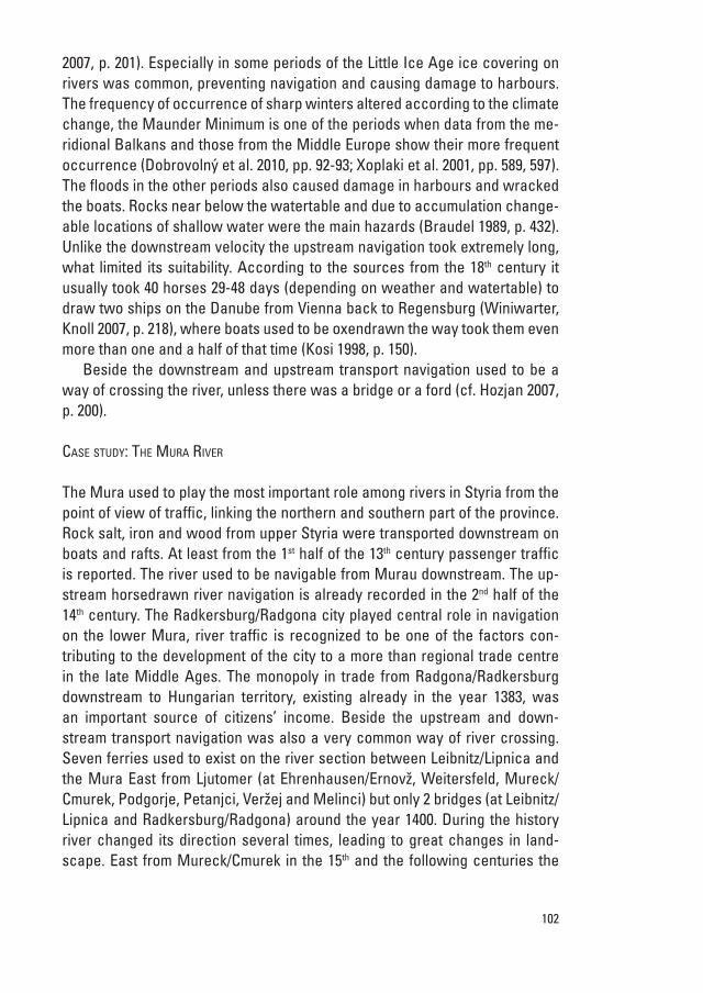
according to some mythographers, the argonauts, coming back from their adventure in the quest for the Golden Fleece1, had to navigate along the Dan-ube river. Having arrived to what is today Beograd, they chose to continue along the sava. so, they navigated up to the lake Bohinj in northwestern slo-venia, where according to the myth they started to push the argo ship on tree trunks for the 15 km separating the lake from the soča river. in this way they were able to reach the adriatic sea and to continue their adventures (Pozzetto, 1988, pp. 373-374). according to the presentation of Bratož quoting Plinius the
1 the Golden Fleece could probably symbolize the knowledge of iron.
105projects – workgroup e
elder they turned from sava to ljubljanica and continued inland towards the adriatic sea (Bratož 2003, pp. 246-247).
Figure 4. The Argonauts’ trip for Plinius the older (I c. a.d.) (Siempre ...)
the first complete project that tackled the problem to connect the sava and the soča was developed in XVii c. and was again topical under maria ther-esia’s rule. the idea was popular till the first decade of XiX c. after that period the project was dismissed. at the end XiX c. the Habsburg empire revitalized the idea of digging a channel, having in mind the limited capacity of the rail-roads to trieste and the perspectives of its port development. an international competition to select the best project on the issue was held in 1904. But WWi made the creation of digging a channel impossible.
max Fabiani, an important architect born in 1865 near Gorizia, and famous for his works in Vienna, ljubljana, trieste and some other parts of the empire, also planned to carry out this important infrastructural project for his whole working period. even after WWii, he tried to persuade italian, Yugoslav and austrian governments of the importance of the channel: he drew a serious plan before his death in 1962. it was based on 1904 competition results and on an original solution proposed by leonardo da Vinci for the part of the soča. obviously, the division of the XX c. europe, two WWs, the cold war and the strained relations between italy, Yugoslavia and the rest of the eastern eu-
106
rope, especially since 1915 till the 1960s, made the non-communication be-tween the north adriatic and the Black sea an important aspect of the europe of borders (Pozzetto, 1988, p. 141; Pasquali, 1992).
east-West relations in europe started to be more open and flexible, after the Helsinki agreement of 1975. thus italy and Yugoslavia finally formalized their frontiers and thanks the osimo agreements started a new cooperation. the channel was officially decided to be built between the two countries, fol-lowing the main two different Fabiani’s projects (supplemento ordinario…, 1977, p. 218). in 1984 in Grado, the italian and Yugoslav ministers of foreign affairs officially ratified the building of the infrastructure (Baggi, 1985, p. 18).
thus italy and the former Yugoslav republics after three decades still of-ficially have to carry out this project. But we, the people of europe, now have a new concept of the relationship between nature and human beings, a new vision of multimodality and transport, we understand that the benefits of well-being of local communities must be integrated in the well-being of national and european population, at the same time not causing environmental damage.
this study aims to present the mentality of past generations feeling the urgency to open wider communications from north adriatic to the Black sea along the DrB. this could give us new opportunities to plan the future in the new european political circumstances, e.g. open borders, one new common political frame, a shared legislation and a vision of peace and prosperity.
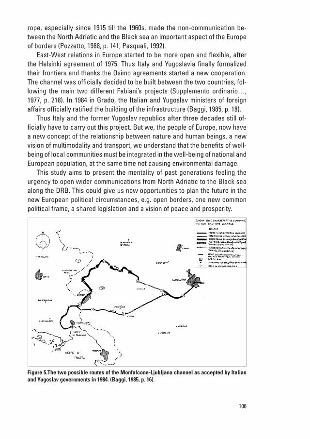
Figure 5.The two possible routes of the Monfalcone-ljubljana channel as accepted by Italian and yugoslav governments in 1984. (Baggi, 1985, p. 16).
107projects – workgroup e
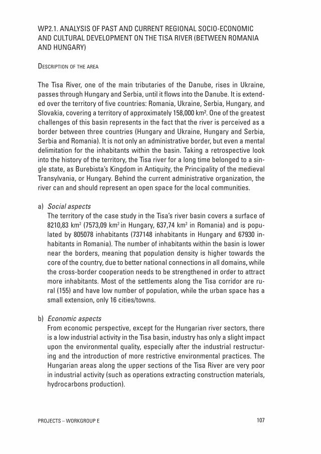
WP2.1. analYsis oF Past anD current reGional socio-economic anD cultural DeVeloPment on tHe tisa riVer (BetWeen romania anD HunGarY)
deSCription of tHe area
the tisa river, one of the main tributaries of the Danube, rises in ukraine, passes through Hungary and serbia, until it flows into the Danube. it is extend-ed over the territory of five countries: romania, ukraine, serbia, Hungary, and slovakia, covering a territory of approximately 158,000 km². one of the greatest challenges of this basin represents in the fact that the river is perceived as a border between three countries (Hungary and ukraine, Hungary and serbia, serbia and romania). it is not only an administrative border, but even a mental delimitation for the inhabitants within the basin. taking a retrospective look into the history of the territory, the tisa river for a long time belonged to a sin-gle state, as Burebista’s Kingdom in antiquity, the Principality of the medieval transylvania, or Hungary. Behind the current administrative organization, the river can and should represent an open space for the local communities.
a) Social aspectsthe territory of the case study in the tisa’s river basin covers a surface of 8210,83 km2 (7573,09 km2 in Hungary, 637,74 km2 in romania) and is popu-lated by 805078 inhabitants (737148 inhabitants in Hungary and 67930 in-habitants in romania). the number of inhabitants within the basin is lower near the borders, meaning that population density is higher towards the core of the country, due to better national connections in all domains, while the cross-border cooperation needs to be strengthened in order to attract more inhabitants. most of the settlements along the tisa corridor are ru-ral (155) and have low number of population, while the urban space has a small extension, only 16 cities/towns.
b) Economic aspectsFrom economic perspective, except for the Hungarian river sectors, there is a low industrial activity in the tisa basin, industry has only a slight impact upon the environmental quality, especially after the industrial restructur-ing and the introduction of more restrictive environmental practices. the Hungarian areas along the upper sections of the tisa river are very poor in industrial activity (such as operations extracting construction materials, hydrocarbons production).
108
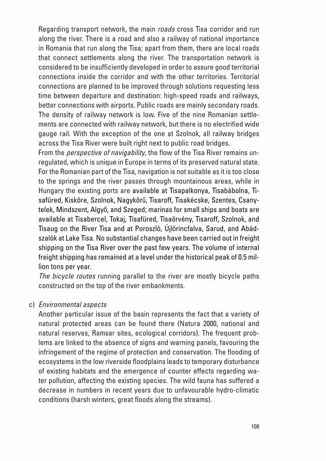
regarding transport network, the main roads cross tisa corridor and run along the river. there is a road and also a railway of national importance in romania that run along the tisa; apart from them, there are local roads that connect settlements along the river. the transportation network is considered to be insufficiently developed in order to assure good territorial connections inside the corridor and with the other territories. territorial connections are planned to be improved through solutions requesting less time between departure and destination: high-speed roads and railways, better connections with airports. Public roads are mainly secondary roads. the density of railway network is low. Five of the nine romanian settle-ments are connected with railway network, but there is no electrified wide gauge rail. With the exception of the one at szolnok, all railway bridges across the tisa river were built right next to public road bridges.From the perspective of navigability, the flow of the tisa river remains un-regulated, which is unique in europe in terms of its preserved natural state. For the romanian part of the tisa, navigation is not suitable as it is too close to the springs and the river passes through mountainous areas, while in Hungary the existing ports are available at tisapalkonya, tisabábolna, ti-safüred, Kisköre, szolnok, nagykörű, tisaroff, tisakécske, szentes, csany-telek, mindszent, algyő, and szeged; marinas for small ships and boats are available at tisabercel, tokaj, tisafüred, tisaörvény, tisaroff, szolnok, and tisaug on the river tisa and at Poroszló, Újlőrincfalva, sarud, and abád-szalók at lake tisa. no substantial changes have been carried out in freight shipping on the tisa river over the past few years. the volume of internal freight shipping has remained at a level under the historical peak of 0.5 mil-lion tons per year.The bicycle routes running parallel to the river are mostly bicycle paths constructed on the top of the river embankments.
c) Environmental aspectsanother particular issue of the basin represents the fact that a variety of natural protected areas can be found there (natura 2000, national and natural reserves, ramsar sites, ecological corridors). the frequent prob-lems are linked to the absence of signs and warning panels, favouring the infringement of the regime of protection and conservation. the flooding of ecosystems in the low riverside floodplains leads to temporary disturbance of existing habitats and the emergence of counter effects regarding wa-ter pollution, affecting the existing species. the wild fauna has suffered a decrease in numbers in recent years due to unfavourable hydro-climatic conditions (harsh winters, great floods along the streams).
109projects – workgroup e
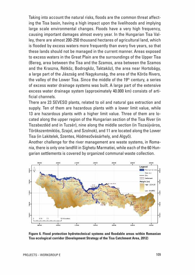
taking into account the natural risks, floods are the common threat affect-ing the tisa basin, having a high impact upon the livelihoods and implying large scale environmental changes. Floods have a very high frequency, causing important damages almost every year. in the Hungarian tisa Val-ley, there are almost 200-250 thousand hectares of agricultural land, which is flooded by excess waters more frequently than every five years, so that these lands should not be managed in the current manner. areas exposed to excess waters in the Great Plain are the surroundings of the upper tisa (Bereg, area between the tisa and the szamos, area between the szamos and the Kraszna, rétköz, Bodrogköz, taktaköz), the area near Hortobágy, a large part of the jászság and nagykunság, the area of the Körös rivers, the valley of the lower tisa. since the middle of the 19th century, a series of excess water drainage systems was built. a large part of the extensive excess water drainage system (approximately 40.000 km) consists of arti-ficial channels.there are 23 seVeso plants, related to oil and natural gas extraction and supply. ten of them are hazardous plants with a lower limit value, while 13 are hazardous plants with a higher limit value. three of them are lo-cated along the upper region of the Hungarian section of the tisa river (in tiszabezdéd and in tuzsér), nine along the middle section (in tiszaújváros, törökszentmiklós, szajol, and szolnok), and 11 are located along the lower tisa (in lakitelek, szentes, Hódmezővásárhely, and algyő). another challenge for the river management are waste systems, in roma-nia, there is only one landfill in sighetu marmatiei, while each of the 60 Hun-garian settlements is covered by organized communal waste collection.
Figure 6. Flood protection hydrotechnical systems and floodable areas within Romanian Tisa ecological corridor (Development Strategy of the Tisa Catchment Area, 2012)
110
d) Cultural aspectsthe tisa river and its immediate environment, even in its present form, is among those european rivers preserved in their most natural state. its un-paralleled natural beauty, cultural landscapes, and ecological treasures grant its outstanding importance for the biosphere and biodiversity of the entire carpathian Basin. on romanian territory, the tisa ecological corridor stands out due to a complex natural and anthropogenic tourism potential. in Hungary, the tisa does not play an outstanding role in tourism. the at-tractiveness of the large and medium-sized cities based on their architec-tural heritage, their cultural events, and occasionally, on their thermal spas is emphasized while in some small settlements, water sports tourism has become a central theme of the tourist’s experience.
WP3.1. stuDY oF nature ProtecteD areas anD tHeir use For touristic PurPoses in isonZo/soČa riVer
as can be seen from the s.W.o.t. analysis isonzo/soča river has many na-ture protected areas which are often not valued as they should be, especial-ly in comparison with the valorisation of many historical sites interested by Pic/PPs interreg iiia italia-slovenja 2000-2006. enhance natural areas rep-resents a unique opportunity for sustainable tourism, therefore we intend to implement boat tourist adventures into these area. the tourism in nature pro-tected areas allows people to experience the natural heritage of a country without damaging it. it is extremely important aspect of the economic policy of any country. throughout the world there are areas of great beauty and eco-logical importance yet to be discovered by tourists. nature tourism is able to create local jobs based on a concept of sustainable and responsible tourism. it is therefore possible to implement sustainable development in some of these natural areas in order to promote and better protect them. Furthermore, with the creation of a range of sustainable accommodation facilities in the region we can avoid those countless examples of defacement of the natural land-scape caused by an uncontrolled expansion of tourism in areas of high natural value. this work is intended as a support tool for tourists wishing to engage in exploring the nature and biodiversity in the isonzo/soča river.
a visit to a natural area can offer time for meditation and reflection out of the routine of daily life. this kind of tourism offers not just a passive but an integral experience through a number of activities such as hiking, horse rid-ing, cycling, bird watching etc. the purpose of this study is to investigate how protected areas could be implemented into programs of sustainable tourism.
111projects – workgroup e
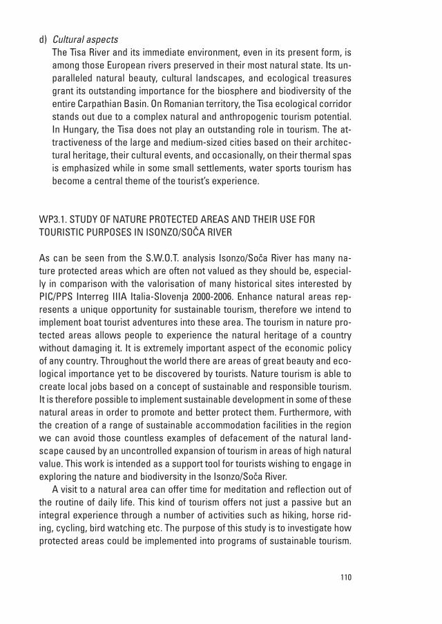
Figure 7. Map of protected areas in Italian part of the Isonzo/Soča River Basin and proposed touristic activities
Table 2. Nature protected areas and their possible use for touristic purposes in Isonzo/Soča River
Nature protected areas Important fauna and flora Tourist activities
Alpi Giulie, Rio Bianco, Marano, Grado
Natural semi natural vegetation, swamps
e.g. botanical excursions and bird watching
Valle Cavanata e Banco Mula di Muggia
Amphibians, reptiles, birds, fishes, swamps
e.g. bird watching
Tolmino, Aree Carsiche della venezia Giulia
Caves, sinkholes, amphibians, reptiles, birds,
insects, swamps
e.g. entomological excursions and recreational
activities
Palude del Preval, Laguna di Marano e Grado
Fishponds, natural vegetation, swamps
e.g. recreational activities
Natisone Fish reserves no activities allowed
112
Particularly which touristic activities would be appropriate in nature protected areas. this study is also relevant for raising awareness in local communities. By using natural heritage for tourism purposes the local communities will have direct economic benefits. these approach to the nature conservation will not be seen an obstacle in regional development but as an opportunity.
the method for producing guidelines is based on a comprehensive study of the natural areas of isonzo/soča river. We studied accessibility of nature parks, their vulnerability and interesting fauna and flora in order advice on the possibilities to use them for sustainable tourism. each colour is matched to a different category of protected areas in order to respond to the demands of the most demanding tourist.
in order to biomonitor the impacts of tourism in protected areas we rec-ommend implementation of biomonitoring that will focus on indicator group species (e.g. birds). Biomonitoring will occur periodically in order to evaluate the impacts. the changes in population numbers will be an indicator for future management of tourism impact. in areas of botanical interest we intend to implement tourist paths in order to prevent creating major damage to flora and fauna.
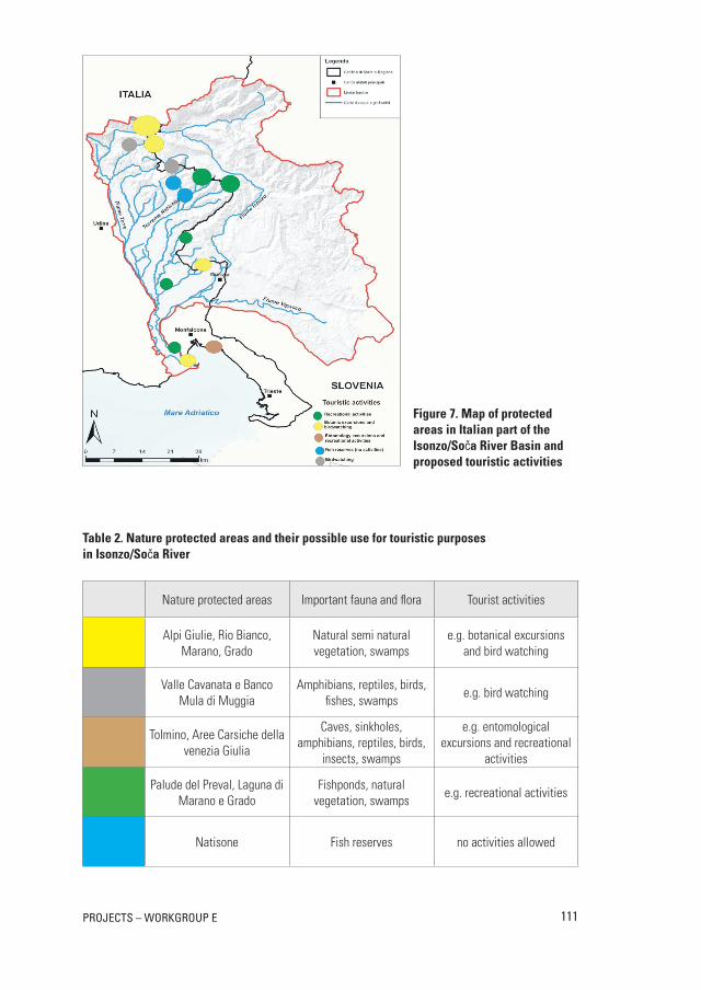
WP4.1. moDel For tHe imPlementation oF ParticiPatorY aPProacH in Decision-maKinG Process in stuDieD reGions
Fair and sustainable agreement in sharing the common water resources is one of the grates challenges for 19 countries in the Danube river Basin. strategic alliances with different stakeholders are essential in successful implementa-tion of any regional management strategy. Participatory and integrated man-agement strategies should be built on environmental, social, cultural and eco-nomic objectives to promote coherent sustainable development in the studied areas.
Participatory decision making-model (antunes et al., 2006) is a relevant method to advance the decision-making process and to analyse the oppor-tunities for different stakeholders in the field of local tourism along the Dan-ube and north adriatic river Basin. Developing sustainable family farms, food production, accommodation etc. are necessary to provide tourists with local products and facilities. this is a multidimensional task. the participatory plan-ning process works to find solutions that are acceptable to all stakeholders (citizens, local authorities, entrepreneurs etc.) and suitable from socio-eco-nomical, ecological and also cultural aspects. Bellow a model of stakeholder analysis and participatory decision making process is outlined (Figure 8).
113projects – workgroup e
Figure 8. Model of stakeholder analysis and participatory decision making process
5. BRIEF CoNClUSIoN
in conclusion, we would like to stress out that the integration of history, envi-ronmental issues, economy and culture is essential for achieving sustainable solutions in any field. Proposed project offers an idea for connecting periph-eral areas of Danube river Basin to its “mainstream”, connecting people and regions from north adriatic to the Black sea. Proposed project would also contribute to cross-border cooperation and sustainable development of Dan-ube river Basin, offering new sustainable tourism development strategy, built on natural and cultural diversity of the regions alongside the rivers.
Working on the project proposal, we experienced enormous potential of transnational and interdisciplinary cooperation. this opportunity gave us a great personal satisfaction, both from a human and professional side.
114
reFerences
antunes, P., santos, r., Videira, n. 2006. Participatory decision making for sustainable development – the use of mediated modelling techniques. land use Policy, 23: pp. 44-52.
Baggi, G. 1985. Quella chiatta per lubiana. il territorio, 6: pp. 15-18.
Braudel, F. 1989. igre menjave: materialna civilizacija, ekonomija in kapitalizem XV.–XViii. stoletje: i [les jeux de l’échange: civilisation matérielle, économie et capitalisme, XVe-XViiie siècle]. ljubljana, Znanstveni inštitut Filozofske fakultete.
Bratož, r. 2003. Grška zgodovina. ljubljana, Zveza zgodovinskih društev slovenije.
Development strategy of the tisa catchment area. 2012.
Dobrovolný, P., moberg, a., Brázdil, r., Pfister, c., Glaser, r., Wilson, r., van engelen, a., limanówka, D., Kiss, a., Halíčková, m., macková, j., riedmann, D., luterbacher, j., Böhm, r. 2010. monthly, seasonal and annual temperature reconstructions for central europe derived from documentary evidence and instrumental records since aD 1500. climatic change, 101: pp. 69-107.
european union strategy for Danube region. 2010. communication from the commission to the european Parliament, the council, the european economic and social committee and the committee of the regions. Brussels, european commission.
Gesamtinventar des steiermärkischen landesarchives. 1959. Graz, steiermärkisches landesarchiv.
Golec, B. 2009. Zemljiški katastri 18. in 19. stoletja kot vir za stavbno, gradbeno in urbanistično zgodovino slovenskega ozemlja – 1. del. arhivi, 32: pp. 283-338.
Horizon 2020: Proposal for a regulation of the european Parliament and of the council establishing Horizon 2020 – the Framework Programme for research and innovation (2014-2020). 2011. Brussels, european commission.
Hozjan, a. 2007. reka Drava in njeni signifikantni kraji na jožefinski vojaški izmeri za ozemlje republike slovenije. ekonomska i ekohistorija, 3: pp. 190-205.
Hughes, j. D. 2008. three dimensions of environmental History. environment and history, 14: pp. 319-330.
Kolar, n. 2011. Plovba po Dravi na ptujskem območju od 15. stoletja do konca 19. stoletja. ekonomska i ekohistorija, 7: pp. 101-110.
Kosi, m. 1998. Potujoči srednji vek. ljubljana, Zrc saZu.
natura 2000. http://ec.europa.eu/environment/ nature/natura2000/ (20 april 2013).
Pasquali, s. 1992. maximilan Fabiani. enciclopedia italiana treccani, appendice V.
Penezic, K., Kadereit, a., thiemeyer, H. 2013. Palaeoenvironment and fluvial history of river Danube between the neolithic settlement sites of Vinca and starcevo, serbia. Geophysical research abstracts: 15. http://meetingorganizer.copernicus.org /eGu2013/eGu2013-12117.pdf.
Petrić, H. 2011. rijeka Drava od Štajersko-hrvatske granice do ušća u Dunav početkom 1780-ih godina. ekonomska i ekohistorija, 7: pp. 49-63.
Pozzetto, m. 1988. max Fabiani: sulla cultura delle città: scritti 1895-1960, trieste, editoriale stampa triestina.
reith, r. 2011. umweltgeschichte der frühen neuzeit. münchen, oldenbourg.
rohr, c. 2007. extreme naturereignisse im ostalpenraum: naturerfahrung im spätmittelalter und am Beginn der neuzeit. Köln, Wien, Weimar, Böhlau.
siempre un poco más lejos. http://journals.worldnomads.com/gododesinquieto /photo/9686/316919/Worldwide/Viaje-de-jason-y-los-argonautas (20 april 2013).
supplemento ordinario alla Gazzetta ufficiale, 77 (21 march 1977).
115projects – workgroup e
Šorn, j. 1984. Začetki industrije na slovenskem. maribor, obzorja.
Water Framework Directive, 2000. Directive 2000/60/ec of the european Parliament and of the council. official journal of the european communities, l 327/1.
Winiwarter, V., Knoll, m. 2007. umweltgeschichte: eine einführung. Köln, Weimar, Wien, Böhlau.
Xoplaki, e., maheras, P., luterbacher, j. 2001. Variability of climate in meridional Balkans during the Periods 1675-1715 and 1780-1830 and its impact on Human life. climatic change, 48: 581-615.