Embed Size (px)
Citation preview

VISIONArden

© VICTORIAN PLANNING AUTHORITY 2018
The Arden Vision has been developed by the Victorian Planning Authority (VPA) on behalf of the Victorian Government in collaboration with the City of Melbourne; the Department of Environment, Land, Water and Planning (DELWP); the Department of Economic Development, Jobs, Transport and Resources (DEDJTR); Development Victoria (DV); Rail Projects Victoria (RPV) and other Victorian Government departments and agencies.
Any projections are based on reasonable assumptions at the time of publication but should not be relied upon without first seeking appropriate expert advice. Although every effort has been made to ensure the information in this document is factually correct at the time of publication, the VPA does not warrant the accuracy, completeness or relevance of the information. Any person using or relying on this document does so on the basis that the State of Victoria shall bear no responsibility or liability whatsoever for any errors, faults, defects or omissions in the information.
Printed on 100% recycled paper
Before European settlement in 1835, Aboriginal people lived on the land now called Melbourne for tens of thousands of years.
We acknowledge Aboriginal people as Australia’s first peoples and as the Traditional Owners and custodians of the land and water on which we rely. We recognise and value the ongoing contribution of Aboriginal people and communities to Victoria and how this enriches us. We embrace the spirit of reconciliation, working towards the equality of outcomes and ensuring an equal voice.
ABORIGINAL ACKNOWLEDGEMENT
Your partner in planning great places for a growing Victoria

One of the secrets of Melbourne’s success is its diversity. Ever since the Gold Rush, ours has been a city of many cultures, languages and places.
Our diversity is what has enabled us to become Australia’s capital of everything from sport to innovation to the arts and to food.
One of the goals of Plan Melbourne 2017–2050 is to protect that diversity in our suburbs and neighbourhoods as we grow. Another goal is to harness population growth that gives Victoria the critical mass of new ideas and people it needs to care for an ageing population, create new employment opportunities, and make the transition to a low carbon economy.
With our city’s population set to top 8 million by 2050 we have to break the link between growth and congestion if we want to make Victoria a global leader in productivity, sustainability and liveability.
That is why the Victorian Government is committed to projects that build stronger communities and tackle congestion, such as the Metro Tunnel Project and the new North Melbourne Station at the heart of the Arden urban renewal precinct.
Arden is of national significance. It is a unique opportunity to create a new hub for the kinds of industries based on innovation, research and knowledge, that Victoria needs to maintain its high standard of living into the 21st century and beyond.
It will also be an inclusive, creative, sustainable neighbourhood that could become the Melbourne equivalent of San Francisco’s Multimedia Gulch, the industrial and residential zone south of Market Street that, during the 1990s, contributed so much to that city’s vibrancy.
This document sets out the key directions that will be followed in more detailed planning for Arden as a new destination to be proud of. It was developed through an extensive public consultation process, including release of the draft Arden Vision and Framework in September 2016. A summary of feedback received during consultation was circulated to all stakeholders in April 2017 and detailed issues have been worked through with the City of Melbourne.
Revisions to the draft Vision following the consultation period have included expanding the number of key directions from five to eight and providing more emphasis on outcomes for each direction.
The Arden Vision confirms the Government’s intentions for the precinct, identifying a range of constraints and opportunities. However, this is simply the end of the first phase of planning.
The next step is to align the detailed planning of the area around the new North Melbourne Station with the Metro Tunnel Project and to work through the concepts for the precinct and its three sub-precincts with stakeholders.
This work will produce the Arden Structure Plan. It will show how the vision for Arden will be achieved over time and will include proposals for changes to the planning scheme. There will be thorough consultation on all of these proposals before they are introduced.
I thank all those who have contributed to shaping the vision for Arden, including residents, landowners, local businesses, design professionals, students, and future residents and workers, and Iwelcome the further involvement of all through consultation on the Arden Structure Plan.
FOREWORDSHon. Richard Wynne MP Minister for Planning
FOREWORDS ARDEN VISION 3

Melbourne is Australia’s fastest growing city.
Our population grew by 107,000 people last year and by 2050, Victoria is projected to have a population of 10 million, with 8 million of those people living in Melbourne.
To prepare for this growth, Melbourne needs to evolve by creating space for new homes and new jobs while making the city more affordable, accessible and less congested.
To achieve this, a more efficient and connected transport network is essential. That’s why the Andrews Labor Government is delivering projects like the $11 billion Metro Tunnel Project, the North East Link, the West Gate Tunnel and the Mernda Rail Extension, while removing 50 of Melbourne’s most dangerous and congested level crossings.
Without a doubt, the cornerstone project is the Metro Tunnel and it’s easy to see why. Every dollar spent building the Metro Tunnel, which will free up space in the City Loop to run more trains in and out of the city, will bring a return to the economy of $1.50, with the Arden precinct to be one of the major beneficiaries.
By 2025, Arden will have its own underground train station linking the precinct to Parkville and the CBD, as well as to Sunshine and Dandenong. The Metro Tunnel will also create a network of linked precincts for living, learning and working. Arden will provide a critical link between Melbourne’s planned and existing renewal precincts, including Docklands and in the longer term, Dynon and E-Gate.
Given its proximity to the University of Melbourne and the Parkville National Employment and Innovation Cluster, Arden has great potential for employment growth.
But we can’t afford to wait for 2025 to realise that potential. We need to start building the foundations of Arden now so that the precinct is well on its way to becoming the vibrant, connected and liveable space it needs to be.
Hon. Jacinta Allan MP Minister for Public Transport & Minister for Major Projects
FOREWORDSARDEN VISION4
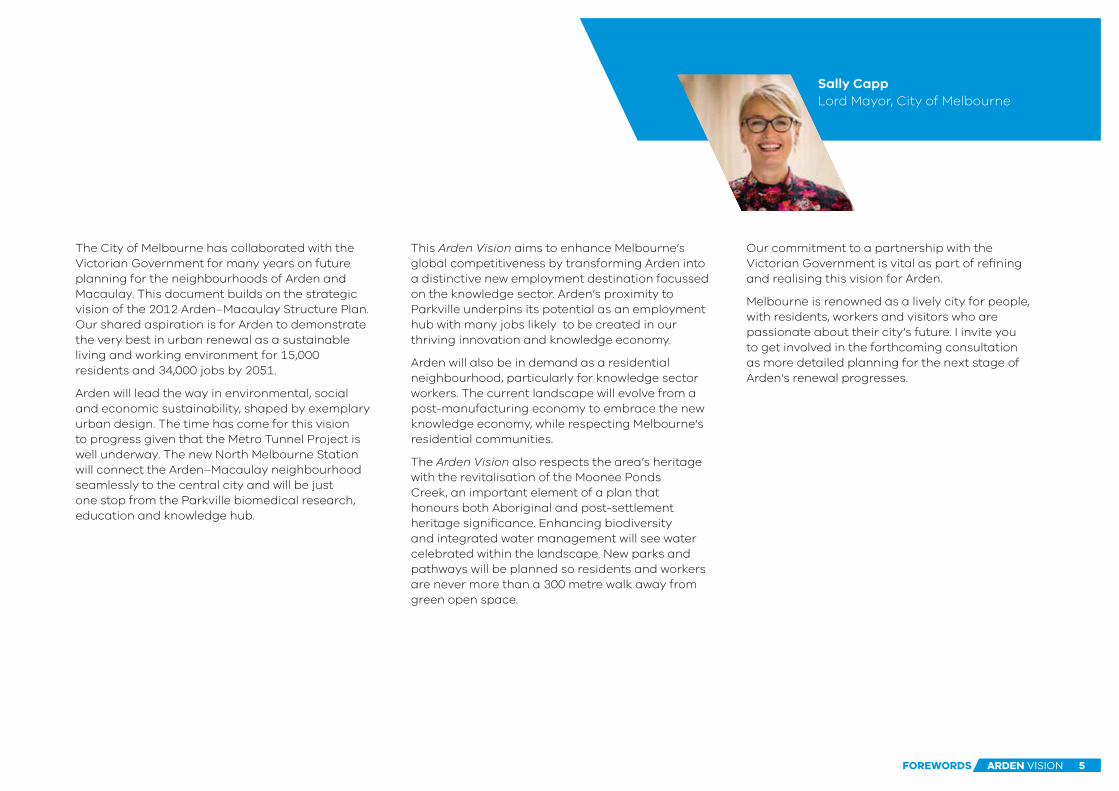
The City of Melbourne has collaborated with the Victorian Government for many years on future planning for the neighbourhoods of Arden and Macaulay. This document builds on the strategic vision of the 2012 Arden–Macaulay Structure Plan. Our shared aspiration is for Arden to demonstrate the very best in urban renewal as a sustainable living and working environment for 15,000 residents and 34,000 jobs by 2051.
Arden will lead the way in environmental, social and economic sustainability, shaped by exemplary urban design. The time has come for this vision to progress given that the Metro Tunnel Project is well underway. The new North Melbourne Station will connect the Arden–Macaulay neighbourhood seamlessly to the central city and will be just one stop from the Parkville biomedical research, education and knowledge hub.
This Arden Vision aims to enhance Melbourne’s global competitiveness by transforming Arden into a distinctive new employment destination focussed on the knowledge sector. Arden’s proximity to Parkville underpins its potential as an employment hub with many jobs likely to be created in our thriving innovation and knowledge economy.
Arden will also be in demand as a residential neighbourhood, particularly for knowledge sector workers. The current landscape will evolve from a post-manufacturing economy to embrace the new knowledge economy, while respecting Melbourne’s residential communities.
The Arden Vision also respects the area’s heritage with the revitalisation of the Moonee Ponds Creek, an important element of a plan that honours both Aboriginal and post-settlement heritage significance. Enhancing biodiversity and integrated water management will see water celebrated within the landscape. New parks and pathways will be planned so residents and workers are never more than a 300 metre walk away from green open space.
Our commitment to a partnership with the Victorian Government is vital as part of refining and realising this vision for Arden.
Melbourne is renowned as a lively city for people, with residents, workers and visitors who are passionate about their city’s future. I invite you to get involved in the forthcoming consultation as more detailed planning for the next stage of Arden’s renewal progresses.
Sally Capp Lord Mayor, City of Melbourne
FOREWORDS ARDEN VISION 5

ARDEN VISION6

FOREWORDS 3
THE VISION FOR ARDEN 8
EXECUTIVE SUMMARY 10
ARDEN TODAY 14
SHAPING ARDEN FOR TOMORROW 16
KEY DIRECTIONS FOR RENEWAL 20
1 Transforming Arden 22
2 Designing a distinctive place 25
3 Embedding sustainable change 28
4 Accommodating diverse communities 30
5 Prioritising active transport 32
6 Investing in community infrastructure 35
7 Celebrating water 37
8 Creating diverse open spaces 41
NEXT STEPS 44
HOW TO BE INVOLVED 46
USEFUL LINKS 47
GLOSSARY 48
FIGURES 50
TRANSLATING & INTERPRETING SERVICE 51
CONTENTS
ARDEN VISION 7

Arden will be a new destination for Melbourne, setting the standard for urban renewal. It will contribute to a future Melbourne that is not only the world’s most liveable city, but also one of the most forward-looking.
With its rapid rail connections to the Parkville National Employment and Innovation Cluster, the Central Business District and Melbourne’s western suburbs, Arden is ideally placed to be an international innovation and technology precinct.
This new employment hub will be pivotal to the growth of Victoria’s knowledge economy and advancing Melbourne’s strengths as a progressive, innovative and connected local and global city.
The precinct will have its own civic heart and character. It will remain connected to its Aboriginal and industrial heritage as it changes to support a diverse resident and worker population. It will become a new neighbourhood of Melbourne with quality and affordable housing, a thriving network of open spaces, active transport links, and adaptable community facilities, schools and workspaces.
Arden will be at the forefront of sustainable development, embracing new ways to live, learn, work and travel in an energy efficient district. Water will be safely managed to become a visible feature in the landscape, while green spaces, trees and water will help the precinct become a cooler, greener version of the city.
The Moonee Ponds Creek corridor will be revitalised as a new green spine for Melbourne. It will be a celebrated waterway with a valued environmental and cultural heritage, serving recreational, biodiversity habitat and active transport functions. The creek corridor will be an essential link for Arden and neighbouring urban renewal precincts.
Partnerships with all levels of government, the community and the private sector will deliver the eight key directions that support the vision for Arden.
THE VISION FOR ARDEN
THE VISION FOR ARDENARDEN VISION8
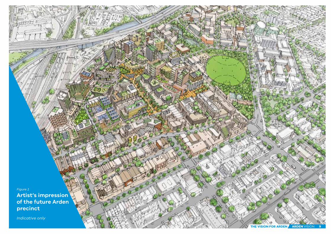
Artist’s impression of the future Arden precinct
Indicative only
Figure 1 a
Figure 1
THE VISION FOR ARDEN ARDEN VISION 9

EXECUTIVE SUMMARYBACKGROUND TO THE ARDEN VISION
Plan Melbourne 2017–2050 is a long-term plan to accommodate Melbourne’s future growth in population and employment. Plan Melbourne identifies state-significant urban renewal precincts in the central city, including the Arden urban renewal precinct.
The Victorian Government and the City of Melbourne are committed to preparing in partnership land use and transport planning frameworks to coordinate and guide planning to 2050. Implementation of these frameworks will be through detailed planning and project delivery at the local level that aligns with state and local government policies and actions.
The Arden Vision is the first step in the implementation of local-level detailed planning for the Arden urban renewal precinct. The Arden Vision confirms shared state and local government intentions for the precinct and will guide the next phase of structure planning.
A NEW DESTINATION FOR MELBOURNEArden is known to many as the home of the North Melbourne Football Club, but the area’s diverse industrial history dates from the 19th century and its cultural significance began with the connections of the traditional owners of the land.
With the completion of the Metro Tunnel Project and the new North Melbourne Station by 2025, Arden will become a new destination for Melbourne and a jobs hub on the doorstep of the Central Business District (CBD).
The Metro Tunnel Project will create a new chapter for Arden by:
• Linking the precinct to Parkville and the city, as well as inner suburbs such as Kensington, North Melbourne, West Melbourne, and the booming western suburbs of Footscray, Sunshine and beyond
• Transitioning an industrial pocket near Melbourne’s CBD into a new jobs destination
• Creating a platform for sustainability, liveability, investment and innovation.
In the wider context, large urban renewal projects like Arden are vital to retaining Melbourne’s liveability as it grows beyond 8 million people.
Planning now for Arden will ensure the precinct capitalises on the investment in infrastructure and place making. As a key part of Melbourne’s evolution, it will set new standards for urban renewal, creating a resilient, diverse and sustainable place to live, learn, work and visit, while showcasing the best that Melbourne and Victoria has to offer.
The Arden Vision builds on the City of Melbourne’s 2012 Arden–Macaulay Structure Plan and on existing Victorian and local government policies that guide economic, social and environmental outcomes for urban renewal.
The Arden Vision has also been strongly shaped by the views of stakeholders and community consultation following the release of the Draft Arden Vision and Framework in September 2016.
In response to consultation feedback, the vision has been refreshed in partnership between the Victorian Government and the City of Melbourne. The Vision now describes three sub-precincts – Arden North, Arden Central and Laurens Street – each with its own identity and unique vision. Eight key directions will guide the renewal of these sub-precincts.
In parallel, additional work has been undertaken with Melbourne Water, the Victorian Planning Authority, other Victorian Government departments and agencies, and the City of Melbourne to develop water-sensitive designs that reduce the impact of flooding. Combined drainage and open space will be part of the solution.
ARDEN VISION10 EXECUTIVE SUMMARY

PURPOSE OF THE ARDEN VISIONThe Arden Vision sets out the priorities that will guide the next steps in the precinct’s development.
Planning for Arden’s future needs to be undertaken now to ensure the precinct is prepared for the opening of the new North Melbourne Station by 2025.
A number of the works required to support the realisation of the Arden Vision and associated projects, including the Metro Tunnel Project, will occur outside the precinct boundaries shown in this document.
Continued involvement from the Victorian Government and the City of Melbourne will ensure the vision for Arden is realised in the structure plan and planning scheme amendment for the precinct, and through the ongoing curation of the precinct beyond the development phase.
The Next Steps section of this document outlines the planning process and delivery of the Arden precinct which will occur across state and local government in consultation with local residents, businesses and landowners.
Figure 2
Artist’s impression of the potential future Capital City open space in ArdenIndicative only
ARDEN VISION 11EXECUTIVE SUMMARY

57
57
57
58
58
59
59
ROYALPARK
MO
ON
EE
PO
ND
S C
RE
EK
NORTHMELBOURNERECREATION
RESERVE
W E S TM E L B O U R N E
N O R T HM E L B O U R N E
K E N S I N G T O N
E - G A T E
TODOCKLANDS
MACAULAY
NORTHMELBOURNE
KENSINGTON
ARDENNORTH
ARDENCENTRAL LAURENS
STREET
WESTMELBOURNE
FLEMINGTO
N ROAD
MAC
AULAY ROAD
LA
NG
FO
RD
ST
RE
ET
ARDEN STREET
CANNING STREET
QUEENSBERRY STREET
FO
GA
RT
Y
VICTORIA STREET
DR
YB
UR
GH
ST
RE
ET
AB
BO
TS
FO
RD
ST
RE
ET
LA
UR
EN
S S
TR
EE
T
CIT
YLI
NK
SPENCER STREET
FOOTSCRAY ROAD
STREET
DYNON ROAD
WEST GATE TUNNEL
WURUNDJERI WAY EXTENSION
1:12,000
0 50 100 150 200 250
Arden sub-precincts
Arden Central sub-regional activity centre
Macaulay neighbourhood activity centre
Arden Street key precinct link
potential new community centre
urban boulevards on Fogarty and Queensberry Streets
Capital City open space at the heart of Arden Central
new neighbourhood open spaces
open space through West Gate Tunnel Project
potential improved open space connection
investigation area for blue-green infrastructure
off-road shared path connection
new/upgraded on-road cycle connection
new permeable street network
West Gate Tunnel Project – under construction
area to be included in the Moonee Ponds Creek masterplanning
Arden precinct boundary
Capital City Trail
new North Melbourne Station & Metro Tunnel – under construction
train station & rail network
tram network
open space
EXISTING FEATURES
HIGHLIGHTS Arden will:
• Create a new destination for Melbourne that is a great place to live, learn, work and visit
• Accommodate more than 34,000 jobs and 15,000 residents by 2051
• Deliver a major transport hub around the new North Melbourne Station
• Enhance the Moonee Ponds Creek corridor to become a valued asset for existing and new communities and the natural environment
• Create two new urban boulevards which will create a civic heart for Arden
• Build on Parkville’s growing role as a technology, life sciences, health and education precinct
• Provide at least 6 per cent of all new housing in the precinct as affordable for low to moderate income households
• Reinforce natural and built heritage to create a new character for the precinct
• Be developed under urban design guidelines that build on Arden’s evolving character
• Be protected by innovative solutions to manage flooding, make better use of water and expand spaces for recreation and biodiversity
• Deliver innovative community hubs and two to four new schools.
PLANNING FOR A GREAT PLACEArden’s reputation as a highly liveable and sustainable precinct will make it a magnet for innovative industries, education and jobs.
The Arden Vision and the eight key directions for the precinct are based on the principle that prosperity, equity, liveability, efficiency and sustainability are complementary goals. They can all be achieved together when urban renewal is well planned.
The key directions that support the vision for Arden include:
1 TRANSFORMING ARDEN
2 DESIGNING A DISTINCTIVE PLACE
3 EMBEDDING SUSTAINABLE CHANGE
4 ACCOMMODATING DIVERSE COMMUNITIES
5 PRIORITISING ACTIVE TRANSPORT
6 INVESTING IN COMMUNITY INFRASTRUCTURE
7 CELEBRATING WATER
8 CREATING DIVERSE OPEN SPACES.
The key directions begin with Arden’s changing economic role. It will be transformed into an innovation, technology-focused jobs hub, while good urban design will make it a liveable and distinctive place. Arden will be a world class example of sustainable urban practice, supported by a range of housing options.
Current and future residents, workers and visitors will be supported by new and revitalised community facilities, prioritised active transport links (walking and cycling) and access to public transport.
Arden has long been in the path of floods and stormwater. Its renewal is the opportunity to make water a valued and visible part of its identity and manage these challenges, rather than hide them away.
A key direction will be to address flood risks and at the same time enhance the Moonee Ponds Creek corridor as a green linear open space. Creating a network of diverse open spaces will be fundamental to the precinct’s liveability and sustainability.
ARDEN VISION12 EXECUTIVE SUMMARY

57
57
57
58
58
59
59
ROYALPARK
MO
ON
EE
PO
ND
S C
RE
EK
NORTHMELBOURNERECREATION
RESERVE
W E S TM E L B O U R N E
N O R T HM E L B O U R N E
K E N S I N G T O N
E - G A T E
TODOCKLANDS
MACAULAY
NORTHMELBOURNE
KENSINGTON
ARDENNORTH
ARDENCENTRAL LAURENS
STREET
WESTMELBOURNE
FLEMINGTO
N ROAD
MAC
AULAY ROAD
LA
NG
FO
RD
ST
RE
ET
ARDEN STREET
CANNING STREET
QUEENSBERRY STREET
FO
GA
RT
Y
VICTORIA STREET
DR
YB
UR
GH
ST
RE
ET
AB
BO
TS
FO
RD
ST
RE
ET
LA
UR
EN
S S
TR
EE
T
CIT
YLI
NK
SPENCER STREET
FOOTSCRAY ROAD
STREET
DYNON ROAD
WEST GATE TUNNEL
WURUNDJERI WAY EXTENSION
1:12,000
0 50 100 150 200 250
Arden sub-precincts
Arden Central sub-regional activity centre
Macaulay neighbourhood activity centre
Arden Street key precinct link
potential new community centre
urban boulevards on Fogarty and Queensberry Streets
Capital City open space at the heart of Arden Central
new neighbourhood open spaces
open space through West Gate Tunnel Project
potential improved open space connection
investigation area for blue-green infrastructure
off-road shared path connection
new/upgraded on-road cycle connection
new permeable street network
West Gate Tunnel Project – under construction
area to be included in the Moonee Ponds Creek masterplanning
Arden precinct boundary
Capital City Trail
new North Melbourne Station & Metro Tunnel – under construction
train station & rail network
tram network
open space
EXISTING FEATURES
The Arden Vision
Figure 3
ARDEN VISION 13EXECUTIVE SUMMARY

FISHERMANSBEND
PORTMELBOURNE
MELBOURNE
SOUTHMELBOURNE
ALBERTPARK
P O R T P H I L L I PB AY
CARLTON
CARLTONNORTH
BRUNSWICKEAST
BRUNSWICK
BRUNSWICKWEST
KENSINGTON
FLEMINGTON
ASCOTVALE
MOONEEPONDS
WESTMELBOURNE
NORTHMELBOURNE
A R D E N
PARKVILLE
SOUTHBANKSOUTHWHARF
DOCKLANDS
1km
2kmThe 50 hectare Arden urban renewal precinct lies west of North Melbourne’s established residential area and south of the Macaulay urban renewal precinct.
Arden has developed a unique character and heritage through the roles it has played. Wide tree-lined streets that date from its time as a main route for travellers to the 19th century goldfields of Ballarat and Bendigo are still evident. The railway lines and roads, industrial buildings and open spaces recall its 20th century role in supporting Melbourne’s growth.
The Moonee Ponds Creek lends the precinct a varied character as it flows south from its highly constrained path under CityLink to a less accessible but greener section towards Dynon Road.This is a reminder of the creek’s role as a food source and meeting place for Aboriginal people.
Arden includes the highly valued North Melbourne Recreation Reserve and North Melbourne Recreation Centre and Pool, and is home to the North Melbourne Football Club. The historic Errol Street shopping strip and the Arts House at the North Melbourne Town Hall are a short walk away.
One of Arden’s strengths is its proximity to the CBD and surrounds, including major hospitals, universities and Royal Park. It is also well connected to other major assets in Melbourne, with a direct link to Melbourne Airport along the CityLink tollway.
West Melbourne Station (currently North Melbourne Station) provides excellent rail access to Upfield, Craigieburn, Sunbury, Werribee and Williamstown lines. The Route 57 tram connects the area to Maribyrnong and the CBD.
As shown in Figure 4, Arden is located between North Melbourne and Kensington and shares strong connections to these areas.
Planning for Arden needs to maintain the liveability of nearby areas, strengthen the role of Errol Street as a local centre, build on Arden’s history and character, and make the most of its transport assets and proximity to major assets and services.
MOONEE PONDS CREEKThe Moonee Ponds Creek, as the name suggests, was once a series of marshy ponds that were isolated in drier periods and flowing in the wetter months. The creek and its environs were a water and food source for Aboriginal people, and a route between the mountains to the north and Port Phillip Bay.
Over time, the creek corridor has been significantly modified to enhance its effectiveness as a drainage corridor and has been degraded by encroaching residential and industrial development along its 25 kilometre journey.
Today the creek also serves as a popular transport route. The Capital City Trail is an important shared use path along the corridor, providing efficient and dedicated access for cyclists and pedestrians to the CBD and Docklands. The CityLink overpass also follows the southern part of the creek corridor.
As the areas of Arden, Macaulay, Docklands, and in the future, E-Gate and Dynon undergo urban renewal, the creek will become a central feature of the city. The Victorian Government is committed to revitalising the Moonee Ponds Creek and strengthening its role as a dynamic corridor.
ARDEN TODAY
Arden’s urban contextFigure 4
ARDEN VISION14 ARDEN TODAY

57
57
57
58
5859
19
59
FLAGSTAFF
WESTMELBOURNE
NORTHMELBOURNE
MACAULAY
KENSINGTON
FLEMINGTONBRIDGE
NEWMARKET
PARKVILLE
MELBOURNECENTRAL
STATELIBRARY
FLEMINGTO
N ROAD
MAC
AULAY ROAD
ARDEN STREET
CANNING STREET
QUEENSBERRY STREET
VICTORIA STREET
AB
BO
TS
FO
RD
ST
RE
ET
DYNON ROAD
CIT
YLI
NK
SPENCER STREET
FOOTSCRAY ROAD
W E S TM E L B O U R N E
P A R K V I L L E
R O YA LP A R K
C A R LT O N
M E L B O U R N EC B D
E - G A T E
D O C K L A N D S
N O R T HM E L B O U R N E
M A C A U L AY
K E N S I N G T O N
38
4
7 9
10
12 13
11
14
15
16
17
22
18
65
19
23
20
21
21
Hotham Hub Children’s Centre
North Melbourne Community Centre
Jean McKendry Neighbourhood Centre
Victorian Archives Centre
North Melbourne Recreation Reserve
Lady Huntingfield Children’s Centre
Royal Children’s Hospital
North Melbourne Primary School
North Melbourne Recreation Centre & Pool
University High School
University of Melbourne
Royal Women’s Hospital
Royal Melbourne Hospital
Victorian Comprehensive Cancer Centre
Errol Street Centre
Queen Victoria Market
Flagstaff Gardens
tram network
North Melbourne Town Hall & Arts House
Metro Tunnel - under construction
rail network
Capital City Trail
1
2
3
4
5
6
7
8
9
10
11
12
13
14
15
16
17
18
Lost Dogs Home
Moonee Ponds Creek Railway Canal
Railway Place and Miller Street Park
19
20
21
RMIT University22
Kensington local activity centre23
1:15,000
0 50 100 150 200 250
Key features of Arden and the surrounding area
Figure 5
ARDEN VISION 15ARDEN TODAY

Sunbury
Parkville
NorthMelbourne
Footscray
Town Hall
State Library
ANZAC
To Bendigo
Parkville NEIC
Central City
SunshineNEIC
To Geelong To Werribee& Williamstown
To Melton& Ballarat
To Sydney
ARDEN
Town Hall
ANZAC
Pakenham
Huntingdale
Caulfield
Clayton
Westall
Dandenong NEIC
Monash NEIC
To Frankston
To CranbourneTo Latrobe
Planning for Arden combines the opportunities offered by its existing assets, such as its distinctive heritage and natural and built character, with new opportunities for redevelopment.
Those new opportunities result from Arden’s place within a chain of renewal precincts, its location close to many transport networks, and the availability of industrial and transport land for more intensive and more mixed uses.
SHAPING ARDEN FOR TOMORROWA CHAIN OF URBAN RENEWALThere are over 600 hectares of land available for urban renewal on the doorstep of Melbourne’s CBD. These precincts include Arden, Docklands, Fishermans Bend, Macaulay and, ultimately E-Gate. Along with Dynon as a future employment and logistics precinct, these areas form a chain of urban renewal opportunities around the CBD.
As outlined in Plan Melbourne 2017–2050, Arden is strategically located on the edge of Melbourne’s central city. The central city area contains key capital city functions and civic facilities as well as precincts identified for major strategic change and renewal.
Central Melbourne’s strengths include a competitive education sector, international linkages, a vibrant mix of activities, a variety of housing and employment opportunities, high levels of amenity, compact form, accessibility, community infrastructure and public transport connections.
Arden’s strategic proximity to Parkville, the CBD and major city assets (as shown in Figure 7), in addition to Victorian Government land ownership and transport investment, will support a scale of development that complements the central city’s knowledge industries and tourism, retail, residential, entertainment, sporting and cultural functions.
TRANSPORT NETWORKS PUT ARDEN AT THE CENTREThe Metro Tunnel Project is crucial to Melbourne’s future and to Arden’s renewal. It will take three of Melbourne’s busiest train lines through a new tunnel under the city, freeing space in the City Loop to run more trains on other lines with greater reliability. The Metro Tunnel Project’s new stations will be named Parkville, State Library, Town Hall, ANZAC and North Melbourne.
As shown in Figure 6, the five new stations will connect the central city to key living, learning and work precincts along the Sunshine–Dandenong rail corridor, including national employment and innovation clusters at Sunshine, Parkville, Monash and Dandenong. The Metro Tunnel Project will also provide more frequent and reliable train services to other significant areas such as Footscray, St Kilda Road, Caulfield, Oakleigh, and Melbourne’s western and eastern growth corridors.
Work on the Metro Tunnel Project began in September 2016. The new North Melbourne Station in Arden, a focal point for the precinct, is due to open by 2025.
Key precincts linked by a high-capacity train network
Figure 6
ARDEN VISION16 SHAPING ARDEN FOR TOMORROW

MELBOURNECENTRAL
FLAGSTAFF
PARLIAMENT
JOLIMONT
WESTRICHMOND
NORTHRICHMOND
COLLINGWOOD
RICHMOND
SOUTHYARRA
PRAHRAN
WINDSOR
WESTMELBOURNE
MACAULAY
FLEMINGTONBRIDGE
KENSINGTON
NEWMARKET
SHOWGROUNDS
FLEMINGTONRACECOURSE
FOOTSCRAY
MIDDLEFOOTSCRAY
WESTFOOTSCRAY
SEDDON
YARRAVILLE
SOUTHKENSINGTON
SOUTHERNCROSS FLINDERS
STREET
ANZAC
TOWN HALL
STATE LIBRARY
PARKVILLE
NORTHMELBOURNE
ROYALBOTANICGARDENS
ALBERTPARK
JL MURPHYRESERVE
WESTGATEPARK
FAWKNERPARK
YARRAPARK
FITZROYGARDENS
CARLTONGARDENS
FLAGSTAFFGARDENS
RONBARASSI
SNR PARK
EDINBURGHGARDENS
PRINCESPARK
ROYALPARK
FOOTSCRAYPARK
JJ HOLLANDPARK
MARIBYRNONG RIVER
YARRA RIVER
ALBERTPARKLAKE
PORT PHILLIPBAY
CIT
YL
INK
CITYLINK
WURUNDJER
I WAY EXTEN
SION
WEST G
ATE TUNNEL
WEST GATE FREEWAY
MELBOURNEZOO
MELBOURNEMUSEUM
PARLIAMENTHOUSE
MCG
MELBOURNE &OLYMPIC PARKS
GOVERNMENTHOUSE
NATIONAL GALLERYOF VICTORIA
ARTS CENTRE
FEDERATIONSQUARE
TOWN HALL
SHRINE OFREMEMBRANCE
MELBOURNE CONVENTION& EXHIBITION CENTRE
ETIHADSTADIUM
QUEEN VICTORIAMARKET
STATIONPIER
ROYAL EXHIBITIONBUILDING
RMIT AUSTRALIAN CATHOLICUNIVERSITY
UNIVERSITY OFMELBOURNE
ROYAL CHILDREN’SHOSPITAL
ROYAL MELBOURNEHOSPITALROYAL WOMEN’S
HOSPITAL
VICTORIANCOMPREHENSIVECANCER CENTRE
ST VINCENT’SHOSPITAL
ROYAL VICTORIANEYE & EAR HOSPITAL
EPWORTHRICHMOND
HOSPITAL
ALFREDHOSPITAL
W I R R A W AY
F I S H E R M A N S B E N DN E I C
P O R T O F M E L B O U R N E
A R T S
S P O R T S
S T K I L D AR O A D
PA R K V I L L EN E I C
S A N D R I D G E
L O R I M E R S O U T H B A N K
RICHMOND TODOCKLANDS CORRIDOR
D O C K L A N D S
E - G A T E
D Y N O NARDEN
M A C A U L AY
N O R T H B A N K
M O N T A G U E
Central Business District
National Employment & Innovation Cluster (NEIC)
priority major urban renewal precinct (2015–2051+)
other urban renewal precinct (2015–2051+)
health facility
education facility
key precinct
freight & logistics
landmark
public open space
Metro Tunnel
state-significant road corridor
West Gate Tunnel Project – under construction
rail network & station
tram network
water body 1:40,000
0 200 400 600 800 1,000
Arden’s central city urban renewal context
Figure 7
ARDEN VISION 17SHAPING ARDEN FOR TOMORROW
MACAULAY
WESTMELBOURNE
NORTHMELBOURNE
KENSINGTON
FLEMINGTONBRIDGE
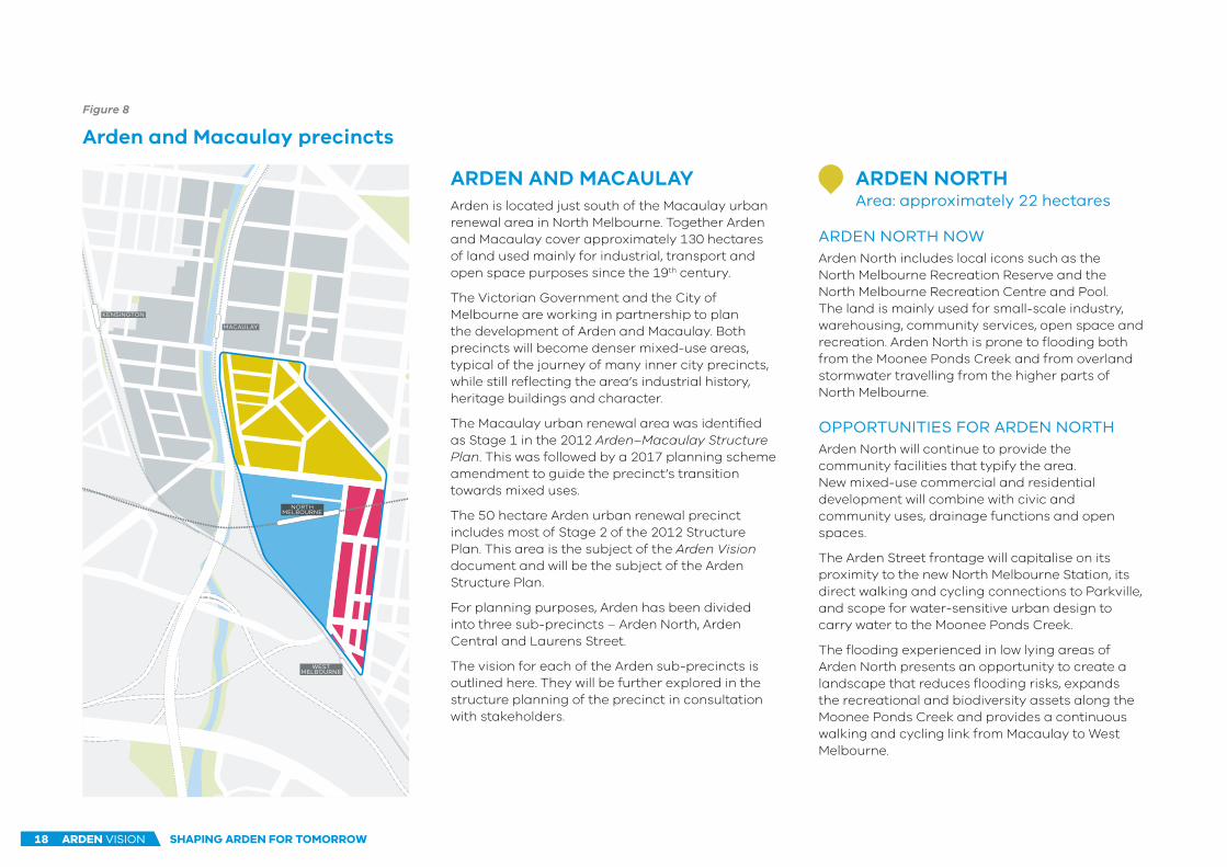
ARDEN AND MACAULAYArden is located just south of the Macaulay urban renewal area in North Melbourne. Together Arden and Macaulay cover approximately 130 hectares of land used mainly for industrial, transport and open space purposes since the 19th century.
The Victorian Government and the City of Melbourne are working in partnership to plan the development of Arden and Macaulay. Both precincts will become denser mixed-use areas, typical of the journey of many inner city precincts, while still reflecting the area’s industrial history, heritage buildings and character.
The Macaulay urban renewal area was identified as Stage 1 in the 2012 Arden–Macaulay Structure Plan. This was followed by a 2017 planning scheme amendment to guide the precinct’s transition towards mixed uses.
The 50 hectare Arden urban renewal precinct includes most of Stage 2 of the 2012 Structure Plan. This area is the subject of the Arden Vision document and will be the subject of the Arden Structure Plan.
For planning purposes, Arden has been divided into three sub-precincts – Arden North, Arden Central and Laurens Street.
The vision for each of the Arden sub-precincts is outlined here. They will be further explored in the structure planning of the precinct in consultation with stakeholders.
ARDEN NORTHArea: approximately 22 hectares
ARDEN NORTH NOWArden North includes local icons such as the North Melbourne Recreation Reserve and the North Melbourne Recreation Centre and Pool. The land is mainly used for small-scale industry, warehousing, community services, open space and recreation. Arden North is prone to flooding both from the Moonee Ponds Creek and from overland stormwater travelling from the higher parts of North Melbourne.
OPPORTUNITIES FOR ARDEN NORTHArden North will continue to provide the community facilities that typify the area. New mixed-use commercial and residential development will combine with civic and community uses, drainage functions and open spaces.
The Arden Street frontage will capitalise on its proximity to the new North Melbourne Station, its direct walking and cycling connections to Parkville, and scope for water-sensitive urban design to carry water to the Moonee Ponds Creek.
The flooding experienced in low lying areas of Arden North presents an opportunity to create a landscape that reduces flooding risks, expands the recreational and biodiversity assets along the Moonee Ponds Creek and provides a continuous walking and cycling link from Macaulay to West Melbourne.
Arden and Macaulay precincts
Figure 8
ARDEN VISION18 SHAPING ARDEN FOR TOMORROW

The Dock – a model for a potential community facility in Arden North
Artist’s impression of future Arden Central precinct
ARDEN CENTRALArea: approximately 16 hectares
ARDEN CENTRAL NOWArden Central is mainly Victorian Government-owned land used for transport purposes, with a few privately owned parcels on the Arden Street frontage. The Metro Tunnel Project and new North Melbourne Station will transform this area into a major transit-oriented destination that supports intensive activities and complements Melbourne’s central city functions.
OPPORTUNITIES FOR ARDEN CENTRALArden Central will feature a mix of research, commercial, educational, recreational, retail, cultural and residential land uses, with the greatest intensity of activity around the new underground North Melbourne.
This sub-precinct will play a vital role in the metropolitan economy as a hub for jobs, education and innovation, built around the station and a new Capital City open space.
The Capital City open space, local parks and the Queensberry Street and Fogarty Street boulevards will help green the city and bring people together, while flood mitigation works will future proof the station and the wider area.
A staged delivery model for the sub-precinct will be developed across Victorian Government departments and agencies and with the City of Melbourne.
LAURENS STREETArea: approximately 12 hectares
LAURENS STREET NOWThe Laurens Street sub-precinct includes residential, commercial and industrial land uses.
With its heritage buildings and wide tree-lined streets, it forms an interface between North Melbourne and the rest of Arden. It has already become an attractive place to live and its transition from a purely industrial area will continue.
OPPORTUNITIES FOR LAURENS STREETRising up a steep slope from Laurens Street, this sub-precinct provides an ideal opportunity to visually and functionally connect the lower-lying areas that will become Arden Central with the rest of North Melbourne. It has significant potential as a transitional zone for smaller scale residential and commercial development.
Existing industries are likely to remain, and there are opportunities to expand North Melbourne’s vibrant creative start-up sector, including innovative co-working spaces.
Improving walkability and active transport connections by creating through-block links will be a focus of the renewal, as will urban design that ensures new development integrates with the area’s heritage buildings, identity and industrial functions. Artist’s
impression of future Laurens Street
Figure 9
Figure 10
Figure 11
ARDEN VISION 19SHAPING ARDEN FOR TOMORROW

PRIORITISING ACTIVE TRANSPORTArden will provide direct and efficient connections in and around the precinct through safe and attractive public areas. This will include active and public transport networks that will complement the new North Melbourne Station.
INVESTING IN COMMUNITY INFRASTRUCTUREArden will support the existing and new community by providing infrastructure that is integrated with the existing area. The design of community facilities, such as schools, will reflect best practice and community input.
CELEBRATING WATERArden will incorporate water as a feature of the landscape through innovative and creative flood mitigation solutions. The Moonee Ponds Creek corridor will be valued as an environmental, recreational and active transport asset, and an integrated water management approach will ensure that water is shared and reused across the precinct.
CREATING DIVERSE OPEN SPACESArden will be a cooler and greener version of the central city, with a generous and well-connected open space network, providing multi-functional spaces for recreation, socialising, active transport and biodiversity.
TRANSFORMING ARDENArden will advance Melbourne’s strengths as a progressive, innovative and connected local and global city. The new North Melbourne Station will catalyse Arden’s transformation into a new employment hub. There will be significant opportunities for better and diverse ways of working, living and learning, as it evolves from an industrial area into an innovation precinct.
DESIGNING A DISTINCTIVE PLACEArden will be shaped by exemplary urban design and built form, anchored by the valued characteristics that make the suburbs of North and West Melbourne special to its residents and workers. Public areas will respond to the existing environment and strengthen the evolving identity of the precinct.
EMBEDDING SUSTAINABLE CHANGEBest practice standards for environmental, social and economic sustainability will underpin planning for the new communities and buildings, making Arden an exemplar of sustainable urban renewal.
ACCOMMODATING DIVERSE COMMUNITIESArden will cater to a diversity of households across a range of ages and incomes, and address different needs with affordable housing. New homes will be well-designed, accessible and sustainable.
KEY DIRECTIONS FOR RENEWALEight key directions have been shaped through consultation with community, stakeholders and government partners to reflect the environmental, social and economic vision for the Arden precinct:
ARDEN VISION20 KEY DIRECTIONS FOR RENEWAL

Artist’s impression of the potential future Queensberry Street boulevard
Figure 12
Indicative only
Figure 12
ARDEN VISION 21KEY DIRECTIONS FOR RENEWAL

DIRECTION 1TRANSFORMING ARDEN
PLANNED OUTCOMES• Development and intensity of activity
catalysed by the station that supports key research, health and education businesses and industries linked to areas such as Parkville.
• Two new activity centres at Arden Central and Macaulay Road that support local population-based services as well as major retail and cultural services.
• More than 34,000 jobs based in Arden by 2051.
• At least 15 hectares of land within walking distance of the new North Melbourne station at Arden dedicated to intensive employment and mixed-use activities.
OBJECTIVES• Arden will leverage government
landholdings and infrastructure investment to capture economic, social and environmental value and transform the precinct into a destination for Melbourne.
• This major transit-oriented centre will attract central city functions and house diverse and innovative businesses and industries.
• At its heart will be a Capital City open space that provides a high quality place where people meet, play, connect and do business, setting new standards for innovative design of public spaces.
• It will be a distinctive place with an identity that builds on existing assets including North Melbourne’s permeable, connected neighbourhood, heritage buildings and streetscapes and the Moonee Ponds Creek, and uses architecture, art and design to reinforce its identity as a centre of innovation.
• Government will support existing businesses undergoing change within Arden.
• Ongoing government curation beyond the development phase of the precinct will attract investment and make it a great place to live, learn, study and work.
ARDEN VISION22 KEY DIRECTIONS FOR RENEWAL

2016
810
3,120
5,000
7,390
15,000
34,000
2031 2051
FORECASTS FOR GROWTH As Arden changes, it will deliver new jobs and residential growth. As shown in Figure 13, the projected growth in Arden is for approximately 34,000 jobs and 15,000 residents by 2051.
The catalyst for change in Arden is the Metro Tunnel Project and new North
Melbourne Station at the centre of the precinct.
Planning will leverage government landholdings and public
infrastructure investment to transform the precinct.
PLANNING FOR GROWTHLand use planning will provide flexible, well-located spaces that support multiple ways of living and working, and large and small enterprises.
Large enterprises will be attracted to the area by its advantageous location and variety of development opportunities and building types. Smaller companies and creative ventures will be supported by world leading institutions and will help attract workers, residents and visitors.
As Arden evolves to support knowledge industry innovation, it will need spaces for co-working and collaboration, affordable shared research infrastructure (including labs and technical equipment), small-footprint advanced manufacturing plants, clinics for medical trials, multi-purpose education facilities and event spaces, short term accommodation for visiting experts and students, and places to showcase Arden’s outputs to the world.
Such core infrastructure will be supported with enabling spaces that promote informal and formal interaction between industries, an innovatively designed public realm that encourages interactions, and excellent physical and digital connections to other innovation precincts.
Community spaces will bring the new and existing communities together to become civic landmarks that add to the sense of place. Their place-making contribution means they should be provided early in the development of the precinct.
Figure 13
Arden’s projected growth1
1. The number of residents and jobs vary from those stated in the 2016
Melbourne Metro Business Case (p.60), due to the use of different
geographic areas and 2016 Census data in this publication.
Refer to the Useful Links section for the Melbourne
Metro Business Case.
ARDEN VISION 23KEY DIRECTIONS FOR RENEWAL

DOCKLANDS
MACAULAY
ARDEN
PARKVILLENEIC
CBD
PARKVILLEWEST
EASTMELBOURNE
Metro Tunnel
key precinct links
North Melbourne Stationunder construction
North Melbourne Station opens
Development intensifiesaround the station
Mature precinct withinfill opportunities
2020 2025 2030 2035 2040 2045
Arden’s connection to Parkville
Figure 14
SYNERGIES WITH PARKVILLEArden’s strategic proximity to the CBD and Parkville will enable the precinct to support Melbourne’s growth as a city that attracts investment, supports innovation and creates jobs.
Arden’s growth will unlock opportunities in Melbourne’s inner north-west for significantly greater economic output and more accessible jobs. Its growth will leverage the benefits of the Metro Tunnel Project’s connection between Arden and the internationally-renowned health, research and education hub at Parkville to enable the continued growth of the Parkville precinct.
Arden’s shift from an industrial to knowledge-based economy will focus on clustering together small and large organisations that are likely to include technology, health, life sciences, and education sectors. Innovative opportunities will emerge between the different sectors across Parkville and Arden, supported by retail, accommodation, culture and recreation activities.
The next step, the Arden Structure Plan, will identify complementary land uses and public realm strategies to maximise Arden’s synergistic relationship with Parkville.
TIMEFRAMES FOR CHANGEArden’s transformation will be gradual, as the precinct changes from its mainly industrial land uses to more intensive activities that complement Melbourne’s central city functions.
The transition will generate opportunities for government to support existing businesses that are undergoing change to find more suitable locations and will include opportunities for temporary uses to occupy vacant spaces as the precinct evolves.
Arden’s evolution
Figure 15
ARDEN VISION24 KEY DIRECTIONS FOR RENEWAL

DIRECTION 2DESIGNING A DISTINCTIVE PLACE
PLANNED OUTCOMES• Urban design and built form guidelines set
the principles and standards for a quality urban environment on each site.
• Significant industrial buildings are protected and reused, where appropriate. Existing community assets such as the North Melbourne Football Club and the North Melbourne Recreation Centre and Pool continue to contribute to the precinct’s character and liveability.
• Public art and urban design that responds to the cultural heritage, local history and community in the creative design of parks, open spaces, signage and wayfinding.
OBJECTIVES• Arden’s future urban form will reflect its
industrial and heritage buildings, wide tree-lined streets and the Moonee Ponds Creek corridor. These features will be blended with denser jobs and housing and a new urban form.
• A high quality public realm will support investment attraction. It will be consistently delivered over time.
• The diverse economic roles of the precinct will be reinforced by an urban form that accommodates both small and large enterprises and places for living within a fine-grained, permeable and pedestrian- and cycle-friendly environment.
• Intensive activity will be focussed around the new North Melbourne Station.
• The street network will be stimulating, attractive and safe, providing connections to active transport, open space and views to key landmarks.
• Arden’s assets, such as heritage places, natural features and water, will help the urban form to reinforce local identity.
• Urban form will respond with innovative solutions to environmental features such as noise sources.
• Buildings in Arden will demonstrate a commitment to design excellence.
ARDEN VISION 25KEY DIRECTIONS FOR RENEWAL

THE DESIGN CHALLENGE FOR INTERFACE AREASArden is the missing piece between the well-established areas of Kensington and North Melbourne. Sensitive design will be crucial in Arden’s development to integrate new areas with existing areas to ensure the precinct responds to its surrounding context. New development to the east will be designed to integrate with existing residential and mixed-use areas and heritage elements.
Arden’s design context also includes CityLink and the rail corridor interface on the western edge. New development and public spaces will require protection from transport noise. The Moonee Ponds Creek interface, also on the western side, will provide an opportunity to combine open space and flood mitigation solutions.
These interface issues will help guide the urban design and built form guidelines that will be developed through the structure planning process.
BUILT FORM• Small blocks with pedestrian permeability and
avoidance of blank façades.
• Responding to sensitive interfaces, including the Moonee Ponds Creek, transport infrastructure and existing built form.
• The greatest intensity of activity located around the new station and entrances.
• Buildings that are adaptable and adopt best practice environmental sustainability standards.
• Buildings and infrastructure designed to withstand flooding, provide safe access and egress and maintain functionality.
• Buildings and streets that establish views and create gateways, such as to the new North Melbourne Station.
• Buildings that respond to constraints such as noise pollution and soil contamination.
• Taller built form or significant buildings aligned to view lines into and out of the precinct.
• Built form to be flexible and facilitate changing ways of living, learning and working.
STREETS & OPEN SPACES• A quality public realm that serves multiple
functions including urban cooling and sport and recreation opportunities.
• Streets and open spaces that are welcoming and maintain a human scale.
• A sense of identity that reflects existing heritage places, streets, open spaces and waterways.
• Safety in public places, including application of Crime Prevention Through Environmental Design principles.
• The integration of North Melbourne Station with the precinct and opportunities for development around the station entrances.
• Setbacks to natural assets, particularly the Moonee Ponds Creek corridor.
• Water-sensitive urban design in streets and open spaces.
• Public places that meet accessibility standards and cater for all levels of mobility, age, cognitive ability and different cultural backgrounds.
• Solar access to public open space and key streets.
URBAN DESIGN AND BUILT FORM GUIDELINESUrban design and built form guidelines will be prepared to ensure the future urban form reflects the precinct’s existing character, responds to existing constraints and sensitive interfaces creating a safe, attractive and sustainable place to live, learn, work and visit whilst realising Arden’s more intensive land use potential.
The guidelines will include the following aims for buildings, streets and open spaces:
Urban design and built form responses will guide the transition of the precinct to ensure new development and public spaces reflect the history and character of the area and create a great place to live, learn, work and visit.
ARDEN VISION26 KEY DIRECTIONS FOR RENEWAL

Artist’s impression of the potential future Fogarty Street boulevard
Indicative only
Figure 16
Figure 16
ARDEN VISION 27KEY DIRECTIONS FOR RENEWAL

DIRECTION 3EMBEDDING SUSTAINABLE CHANGE
OBJECTIVES• Arden will be a sustainable precinct that is
resilient to a changing climate and adapts to population growth and increasing pressure on natural resources.
• It will create diverse and healthy ecosystems that support community wellbeing and wildlife, reconnecting people to natural environments.
• Best practice standards for environmental, economic and social sustainability will apply to both community and building design and promote the evolution of a low carbon economy.
• The urban structure will support direct and safe cycling and walking networks between key destinations and collaborative efforts to conserve and re-use resources.
PLANNED OUTCOMES• Development that meets the highest
attainable standards under Green Star or equivalent nationally-recognised accreditation for sustainable communities and buildings, and complies with Victorian and local government sustainability policies.
• Future development in Arden benchmarked against the Victorian Government’s commitment under the Climate Change Act 2017 to reduce greenhouse gas emissions for Victoria to zero net emissions by 2050.
• Buildings capable of connecting to available and planned alternative district water, waste and energy sources in line with local policy.
• Development that meets or exceeds targets for urban cooling, extending the tree canopy and protecting biodiversity.
• Sustainable waste and water management systems integrated with the metropolitan waste and resource recovery network, and the existing drainage network.
ARDEN VISION28 KEY DIRECTIONS FOR RENEWAL

Waste minimisation
Sustainable developments
Integrated water and flood management
Environmental, social and economic sustainability will underpin planning
for communities and buildings, making Arden an exemplar of
sustainable urban renewal.RESPONDING TO CLIMATE CHANGE AND POPULATION GROWTHMelbourne will be a very different city by 2050, with projections of a much larger population, a hotter and drier climate and more extreme weather events. Planning and development will need to prepare for these changes to protect the character and liveability of the Arden precinct.
Arden’s leadership in sustainable development will encompass:
• Low-energy, low carbon buildings and infrastructure
• An urban structure that supports active transport
• Integrated water and flood management
• High-quality open spaces and green links for people and biodiversity
• Precinct-wide shared energy, water and waste management systems
• Best practice waste minimisation and conversion of waste to energy
• Environmentally responsive urban design.
ARDEN VISION 29KEY DIRECTIONS FOR RENEWAL

DIRECTION 4ACCOMMODATING DIVERSE COMMUNITIES
OBJECTIVES• Arden will house a diverse population
across a range of ages and incomes and cater for specific housing needs, including for key workers, creative industry workers, students, families, first home buyers and pensioners.
• Housing will be well-designed, accessible and able to accommodate a mix of household types, age groups and abilities.
• Arden will support a mix of housing tenures including private rental, purchased, affordable and social housing.
• Guidelines under recent amendments to the Planning and Environment Act 1987 will give certainty on how affordable housing will be delivered as part of new housing developments.
PLANNED OUTCOMES• A residential population of 15,000 in
Arden by 2051.
• At least six per cent of new residential development delivered through mechanisms such as community housing or shared equity.
• Up to 15 per cent of new housing made available as affordable housing where City of Melbourne-owned land is redeveloped.
• At least 10 per cent of all properties in government-led developments prioritised for first home buyers through the Victorian Government’s Homes for Victorians (2017) initiative.
• At least five per cent of all private housing to be universally accessible, to encourage assisted living and help residents age in place.
ARDEN VISION30 KEY DIRECTIONS FOR RENEWAL

Well-designed, accessible, affordable and diverse housing will cater for a
new population in Arden, including households from a range of ages
and incomes.
Six per cent of new residential development will be
delivered as community housing or shared equity.
AFFORDABLE HOUSING IN FOCUSThe renewal of Arden is a valuable opportunity to provide high quality affordable housing close to jobs, services, transport and the CBD.
Recent legislative changes will support the inclusion of affordable housing in urban renewal areas. The Arden precinct will provide at least six per cent of all housing as affordable housing.
The Victorian Government will provide a number of initiatives through Homes for Victorians (2017)to help deliver affordable housing. They include an initiative for at least 10 per cent of all properties in government-led developments such as Arden to be prioritised for first-home buyers, as well as shared equity schemes, including HomesVic and Buy Assist, and a Social Housing Investment Fund.
The implementation of Plan Melbourne 2017–2050 includes strengthening the planning framework so that local governments can provide incentives to developers to deliver affordable housing.
The City of Melbourne’s 2014–2018 housing strategy and Homes for Victorians nominate Arden as an area where development bonuses could act as incentives for provision of affordable housing during urban renewal.
The mechanisms for delivery of this aspiration will be developed during the structure planning process in consultation with stakeholders.
Urban renewal provides new living opportunities & housing diversity
Accommodating different types of households
A mix of housing
ARDEN VISION 31KEY DIRECTIONS FOR RENEWAL

57
57
57
58
58
59
59
216 219 403 952
40
1 4
02
40
3
941 942 220
216 219
401 403
952
402
951
ROYALPARK
MO
ON
EE
PO
ND
S C
RE
EK
NORTHMELBOURNERECREATION
RESERVE
W E S TM E L B O U R N E
E - G A T E
N O R T HM E L B O U R N E
K E N S I N G T O N MACAULAY
WESTMELBOURNE
NORTHMELBOURNE
KENSINGTON
FLEMINGTO
N ROAD
MAC
AULAY ROAD
LA
NG
FO
RD
ST
RE
ET
CANNING STREET
QUEENSBERRY STREET
FO
GA
RT
Y
VICTORIA STREET
DR
YB
UR
GH
ST
RE
ET
AB
BO
TS
FO
RD
ST
RE
ET
LA
UR
EN
S S
TR
EE
T
CIT
YLI
NK
SPENCER STREET
FOOTSCRAY ROAD
STREET
DYNON ROAD
WEST GATE TUNNEL
WURUNDJERI WAY EXTENSION
TODOCKLANDS
ARDEN STREET
1:12,000
0 50 100 150 200 250
upgraded pedestrian & cycling crossing
Arden precinct boundary
Capital City Trail
on-road allocated cycle lane
new North Melbourne Station & Metro Tunnel – under construction
rail network & train station
tram network
bus network
bridge & crossing
open space
EXISTING FEATURES
new permeable street network
West Gate Tunnel Project – under construction
new/upgraded on-road cycle connection
off-road shared path connection
graduated built form intensity towards North Melbourne Station
DIRECTION 5PRIORITISING ACTIVE TRANSPORT
OBJECTIVES• Priority will be given to active and public
transport to, from and within the precinct |that connects Arden with the CBD, Parkville and the growing western suburbs.
• Arden will be a truly transit-oriented development, with the most intensive activity focused around the new North Melbourne Station to realise the greatest outcomes for active transport within the station catchment at Arden.
• Existing public transport infrastructure and active transport connections will be improved to complement Arden’s new transport hub. This includes the station precincts at the new West Melbourne Station (currently called North Melbourne) and Macaulay.
• Provide safe, direct and efficient on-road and off-road cycling connections to encourage bicycle use for everyday transport throughout the entire precinct.
• Create a network of walkable urban boulevards and streets that will be universally accessible, safe and provide efficient connections throughout the entire precinct.
• Innovative design and cross-government collaboration will shape traffic and freight networks to reduce local impacts, including from the West Gate Tunnel.
• Existing rail and road infrastructure will be leveraged to support Arden’s development.
PLANNED OUTCOMES• Given its geography and limited road
access, by 2051 the mode share of all trips to Arden could be:
· 60 per cent public transport
· 30 per cent active transport (walking and cycling), and
· 10 per cent private vehicles.
• Residents have access to day-to-day destinations within 20 minutes by active transport (walking and cycling) or public transport.
• Pedestrians and cyclists have priority on key streets.
ARDEN VISION32 KEY DIRECTIONS FOR RENEWAL

57
57
57
58
58
59
59
216 219 403 952
40
1 4
02
40
3
941 942 220
216 219
401 403
952
402
951
ROYALPARK
MO
ON
EE
PO
ND
S C
RE
EK
NORTHMELBOURNERECREATION
RESERVE
W E S TM E L B O U R N E
E - G A T E
N O R T HM E L B O U R N E
K E N S I N G T O N MACAULAY
WESTMELBOURNE
NORTHMELBOURNE
KENSINGTON
FLEMINGTO
N ROAD
MAC
AULAY ROAD
LA
NG
FO
RD
ST
RE
ET
CANNING STREET
QUEENSBERRY STREET
FO
GA
RT
Y
VICTORIA STREET
DR
YB
UR
GH
ST
RE
ET
AB
BO
TS
FO
RD
ST
RE
ET
LA
UR
EN
S S
TR
EE
T
CIT
YLI
NK
SPENCER STREET
FOOTSCRAY ROAD
STREET
DYNON ROAD
WEST GATE TUNNEL
WURUNDJERI WAY EXTENSION
TODOCKLANDS
ARDEN STREET
1:12,000
0 50 100 150 200 250
upgraded pedestrian & cycling crossing
Arden precinct boundary
Capital City Trail
on-road allocated cycle lane
new North Melbourne Station & Metro Tunnel – under construction
rail network & train station
tram network
bus network
bridge & crossing
open space
EXISTING FEATURES
new permeable street network
West Gate Tunnel Project – under construction
new/upgraded on-road cycle connection
off-road shared path connection
graduated built form intensity towards North Melbourne Station
Figure 17
Key active transport links
The new North Melbourne Station will be complemented by an active transport network
that allows direct and efficient connections in and around the precinct via safe and
attractive public areas.
ARDEN VISION 33KEY DIRECTIONS FOR RENEWAL

New North Melbourne Station (concept image)
Shared paths
Pedestrian-friendly streets
WALKING AND CYCLINGWalking, cycling and public transport will be key aspects of the day-to-day life of residents, workers and visitors moving to, from and within Arden.
Separated and continuous cycling infrastructure will be designed to ensure safer connectivity throughout the entire precinct to encourage bicycles as part of everyday transport.
Public and active transport connections will come together at the entrances to the new North Melbourne Station.
The most intensive activity will be located around the new North Melbourne Station, to maximise the opportunities to live, learn and work within the station catchment.
Planning will also protect opportunities to connect walking, cycling and public transport users to other urban renewal precincts, including Docklands, E-Gate and Dynon. Pedestrian and cycling connections will be especially important links for accessing regional assets close to the Arden precinct, such as Parkville and Royal Park.
The Victorian Cycling Strategy 2018–28 has the goal of investing in a safer, lower-stress, better-connected network. New cycling infrastructure will be provided from Footscray to North Melbourne in conjunction with the West Gate Tunnel Project.
MANAGING TRAFFICStreets will be designed to meet active transport standards outlined in the City of Melbourne’s Walking Plan and Bicycle Plan, with measures including:
• Traffic calming and reduced speed limits within the precinct to redirect through-traffic around the precinct.
• Crossings and refuges across major arterial roads including Dryburgh Street, Macaulay Road and Boundary Road.
• On-street and off-street parking limitations.
A counterpoint to making active transport more attractive is to reduce reliance on car use. Design and distribution of car parking plays a role in reducing this reliance. The potential for innovative design of parking will be explored in the structure planning of Arden.
The West Gate Tunnel Project completed its environmental assessment in late 2017, with contracts signed in early 2018.
As part of the Minister for Planning’s assessment of the West Gate Tunnel Environmental Effects Statement, there is currently a North and West Melbourne Scoping Study underway led by Transport for Victoria, in participation with the City of Melbourne and other Victorian Government agencies and departments.
This scoping study will identify any works needed to manage traffic flows from the West Gate Tunnel Project and will align these with the City of Melbourne’s streetscaping works in the West Melbourne Structure Plan.
ARDEN VISION34 KEY DIRECTIONS FOR RENEWAL

DIRECTION 6INVESTING IN COMMUNITY INFRASTRUCTURE
OBJECTIVES• Community infrastructure will support
existing and future residents, workers and visitors and enhance community wellbeing.
• It will promote health, education, recreation, cultural development and social inclusion, foster a distinctive sense of place and promote community cohesion from early on in the renewal process.
• Community facilities will be future-proofed to support new ways of working and living through innovative and flexible design.
• The Victorian Government and the City of Melbourne will work in partnership with the private sector to deliver community infrastructure that meets current and future demand.
PLANNED OUTCOMES• Two to four new schools that meet the
demand of the growing populations of the broader West and North Melbourne, including new residents at Arden.
• Timely delivery of conveniently-located community infrastructure that supports the needs of established and incoming workers and residents.
• Two community hubs that bring together and support local and regional residents, workers and visitors.
• Education, sport, recreation and health facilities that are located conveniently within Arden and/or neighbouring areas.
ARDEN VISION 35KEY DIRECTIONS FOR RENEWAL

Community infrastructure will help build the new community and integrate it with the existing area.
SHAPING A COMMUNITYWell-designed community infrastructure enhances wellbeing, contributes to a sense of place and plays an integral role in helping individuals, families and groups meet their everyday social needs and access requirements.
The Arden precinct already includes valued community assets such as the iconic North Melbourne Recreation Centre and Pool and the North Melbourne Recreation Reserve. The North Melbourne Football Club provides a valuable service to the community, including the Huddle youth program.
However, forward planning is required in Arden and North Melbourne to support a growing resident, worker and visitor population.
As space is finite in the inner city, flexible spaces designed to be shared, clever vertical design solutions and innovative delivery will be key to meeting demand for community facilities. This may include building new facilities and upgrading existing facilities to cater for the growing population.
Partnerships between governments, developers and community services can help produce co-located, well-integrated infrastructure that supports shared uses. This could encompass both built facilities and open space assets
The community, private and voluntary sector will be involved from an early stage in the planning and delivery of community facilities as resident and visitor numbers increase.
EDUCATIONAL FACILITIESAs part of the Inner Melbourne New Schools Package, the Victorian Government has identified the potential for new schools to be delivered to service the growing populations across West and North Melbourne.
Two sites are being evaluated to respond to demand in the area, including demand from the future Arden population. The type and governance of any new schools would be informed by community engagement and consultation.
COMMUNITY HUBSThe City of Melbourne’s 2012 Arden–Macaulay Structure Plan identifies the opportunity for a community hub in each precinct. These community hubs will be co-located with existing and proposed activity centres.
They will be designed in consultation with the community to meet the growing demand for a range of spaces that bring people together. They are likely to include spaces for meetings, performances, play, learning and accessing resources. Innovation will be a key objective in developing these community hubs.
Great new schools (South Melbourne Primary School)
Library and community centre
Recreational facilities
ARDEN VISION36 KEY DIRECTIONS FOR RENEWAL

DIRECTION 7CELEBRATING WATER
OBJECTIVES• The Moonee Ponds Creek corridor will be
celebrated as a waterway with recreational, environmental and active transport functions and a valued environmental and cultural heritage.
• The City of Melbourne-led Moonee Ponds Creek plan will identify opportunities to broaden the span of the creek corridor and introduce new open spaces by repurposing adjacent Victorian Government-owned land.
• Integrated water management and water-sensitive design will make Arden greener and more resilient to climate change, reduce flooding risks and make development feasible across the precinct.
• Innovative design for managing and conserving water will be delivered at the building, street and precinct level and by the public and private sectors.
• Blue-green infrastructure (combining open space and flood mitigation) will create a distinctive sense of place around water in the landscape, provide open spaces for recreation and biodiversity, and reduce stormwater and flooding risks.
• Cross-government collaboration will underpin flood mitigation solutions in Arden and the revitalisation of the Moonee Ponds Creek corridor.
PLANNED OUTCOMES• Precinct-wide urban design and built form
guidelines establish a set of principles for managing flood risk and ensuring functionality and safety before individual sites are developed.
• All new development meets recognised best practice water-sensitive urban design standards.
• Flood-prone land protected from the impacts of a 1-in-100 year flood where possible, including flooding due to the effects of a changing climate.
• Where possible, flood-prone land that was previously unavailable for development will be made developable through flood mitigation works, in accordance with relevant standards or urban design requirements.
• Recreation spaces, active transport links, flood mitigation and expanded flora and fauna habitats will be delivered through integrated management of the Moonee Ponds Creek, in accordance with the City of Melbourne-led master planning for the creek corridor.
ARDEN VISION 37KEY DIRECTIONS FOR RENEWAL

27.527.5
2020
202010
10
10
10
1010
2020
3030
3030
1010
1010
1010
2020
2020
33.533.5
22.522.5
ROYALPARK
MO
ON
EE
PO
ND
S C
RE
EK
W E S TM E L B O U R N E
E - G A T E
N O R T HM E L B O U R N E
K E N S I N G T O NMACAULAY
WESTMELBOURNE
NORTHMELBOURNE
KENSINGTON
FLEMINGTO
N ROAD
MAC
AULAY ROAD
LA
NG
FO
RD
ST
RE
ET
ARDEN STREET
CANNING STREET
QUEENSBERRY STREET
FO
GA
RT
Y
VICTORIA STREET
DR
YB
UR
GH
ST
RE
ET
AB
BO
TS
FO
RD
ST
RE
ET
LA
UR
EN
S S
TR
EE
T
CIT
YLI
NK
SPENCER STREET
FOOTSCRAY ROAD
STREET
DYNON ROAD
WEST GATE TUNNEL
WURUNDJERI WAY EXTENSION
1:12,000
0 50 100 150 200 250
investigation area for blue-green infrastructure
West Gate Tunnel Project – under construction
area to be included in the Moonee Ponds Creek masterplanning
Arden precinct boundary
contours 2 metre interval
spot height
existing Land Subject to Inundation Overlay
new North Melbourne Station & Metro Tunnel – under construction
rail network & train station
open space
EXISTING FEATURES
Arden will be a water-sensitive precinct that incorporates water as a landscape feature.
Planning for Arden gives the opportunity to manage the significant flooding challenge, revitalise the Moonee Ponds Creek and deliver improved outcomes for open space, recreation and biodiversity.
Flooding and low-lying areas
Figure 18
ARDEN VISION38 KEY DIRECTIONS FOR RENEWAL

permeablesurfacesrain
gardens
water tanksgreen roofs
third-pipesystems
sewermining
tree pits
creeksidepaths
water interaction
greywater & stormwater re-use
swales &retarding
basins
BUILDINGS
OPEN SPACES
PRECINCTS
Flows to Moonee Ponds Creek, Yarra River &
Port Phillip BayMultiple functions of the Moonee Ponds Creek
THE CHALLENGE OF CLIMATE CHANGEStormwater management projections to the year 2100 indicate an increased risk of flooding due to a combination of sea level rise and more extreme rainfall events.
Flood mitigation measures will need to be strengthened in some flood-prone areas to enable development, particularly in areas close to the Moonee Ponds Creek corridor and other low-lying areas, as shown in Figure 18.
Melbourne Water, in partnership with the VPA, other Victorian Government agencies and the City of Melbourne, are currently investigating various flood mitigation solutions across Arden and Macaulay.
Figure 19
Elements of integrated water management
OPPORTUNITIES FOR INTEGRATED WATER MANAGEMENT The development of Arden is an opportunity to design a new precinct around the principles of integrated water management (IWM).
The IWM approach combines precinct and site-based opportunities to reduce runoff and treat water so that it stays as a resource for the area where it was collected.
As shown in Figure 20, measures such as green roofs, rainwater tanks, on-site retention, permeable paving and small retarding basins will be promoted as part of an IWM strategy to be developed with the Arden Structure Plan.
Figure 20
ARDEN VISION 39KEY DIRECTIONS FOR RENEWAL

Examples of blue-green infrastructure
Tanner Springs, Portland
(Oregon, USA)
Promenada (Velenje, Slovenia)
Figure 21
WATER AS A VISIBLE LANDSCAPE ASSETInnovative solutions under the title of ‘blue-green infrastructure’ are being used around the world to reduce the impacts of urban flooding while providing recreational and biodiversity reserves, especially where space is at a premium.
Under this model, flood and stormwater basins become a visible asset in the landscape instead of being hidden in underground pipes.
Further planning is underway to find appropriate locations to trial new blue-green spaces that safely reduce flood risks and increase available open space. Arden North is a prime location for such a solution, given its existing role as a provider of open space and the risks of flooding in this area.
As well as addressing flooding, blue-green infrastructure can give Arden a distinctive identity as a place that celebrates water. Urban design guidelines will combine safe management of flood potential and celebration of water as a landscape feature in public spaces.
Figure 21 includes examples of the types of water-sensitive urban design that could be provided in Arden.
Cumberland Park, Nashville (Tennessee, USA)
ARDEN VISION40 KEY DIRECTIONS FOR RENEWAL

DIRECTION 8CREATING DIVERSE OPEN SPACES
OBJECTIVES• A generous open space network will
connect new and existing neighbourhoods.
• Open spaces will be diverse in function and size and integrated with walking and cycling links.
• A Capital City open space located in Arden Central will be a key feature of Arden’s new identity, along with new neighbourhood parks and green streets.
• The Moonee Ponds Creek corridor will be rejuvenated as one of Melbourne’s significant and valued waterways and linear open spaces.
• The creek corridor will offer passive and active recreation opportunities.
• The Victorian Government and the City of Melbourne will work in partnership to deliver new open spaces.
PLANNED OUTCOMES• Green streets and open spaces that
contribute to the minimum 40 per cent tree canopy target by 2040 for the City of Melbourne area.
• Open space within 300 metres of all residents and workers in Arden by 2051.
• The City of Melbourne minimum requirement of 7.06 per cent of land available for development allocated for a diverse range of local open spaces, in addition to a Capital City central open space, in accordance with the City of Melbourne’s Open Space Strategy.
• Open spaces are designed to combine passive and open space opportunities with flood mitigation, where needed.
• New open spaces contribute to the stock of accessible active recreation opportunities in North Melbourne.
• Protection of solar access for key open spaces provided through urban design and built form guidelines.
• Garden spaces for local food production included in the development of Arden.
ARDEN VISION 41KEY DIRECTIONS FOR RENEWAL

ROYALPARK
BOUNDARYROAD
RESERVE
CLAYTONRESERVE
NORTHMELBOURNERECREATION
RESERVE
GARDINERRESERVE
MO
ON
EE
PO
ND
S C
RE
EK
W E S TM E L B O U R N E
E - G A T E
N O R T HM E L B O U R N E
K E N S I N G T O NMACAULAY
WESTMELBOURNE
NORTHMELBOURNE
KENSINGTON
4
2
3
6
6
6
6
1
4
5
FLEMINGTO
N ROAD
MAC
AULAY ROAD
LA
NG
FO
RD
ST
RE
ET
CANNING STREET
QUEENSBERRY STREET
FO
GA
RT
Y
VICTORIA STREET
DR
YB
UR
GH
ST
RE
ET
AB
BO
TS
FO
RD
ST
RE
ET
LA
UR
EN
S S
TR
EE
T
CIT
YLI
NK
SPENCER STREET
FOOTSCRAY ROAD
STREET
DYNON ROAD
WEST GATE TUNNEL
WURUNDJERI WAY EXTENSION
ARDEN STREET
1:12,000
0 50 100 150 200 250
potential improved open space connection
potential location of Capital City open space
potential location of open space
open space through West Gate Tunnel Project
new permeable street network
West Gate Tunnel Project – under construction
investigation area for blue-green infrastructure
open space
Arden precinct boundary
rail network & train station
area to be included in the Moonee Ponds Creek masterplanning
urban boulevard treatment
local open space
urban boulevard
Arden Central Capital City open space
links to existing open spaces
station plaza
EXISTING FEATURES
1
2
3
4
5
proposed open space along the Moonee Ponds Creek corridor6
new North Melbourne Station & Metro Tunnel – under construction
Proposed network of diverse open spaces
Figure 22
A generous and well-connected open space network in Arden will help make Arden a cooler, greener version of the central city.
ARDEN VISION42 KEY DIRECTIONS FOR RENEWAL

KEY FEATURES OF THE OPEN SPACE NETWORK
URBAN BOULEVARDSTwo urban boulevards along Queensberry Street and Fogarty Street will create strong physical connections within Arden. High quality urban design, wide footpaths, active transport infrastructure, water sensitive urban design and large canopy trees will be key criteria for the design and functionality of Arden’s new boulevards and will create a people-friendly environment.
ARDEN CAPITAL CITY OPEN SPACEThe intersection of Queensberry and Fogarty streets will open up to Arden Central’s new Capital City open space. This central public space will be a new destination for the precinct that will cater for a diverse range of uses to support the future needs of residents, workers and visitors from all over the city.
MULTIPLE BENEFITS OF OPEN SPACEPublic open spaces incorporate publicly-owned streets, laneways, shared paths and public spaces. They create opportunities for social interaction, relaxation, and formal and informal recreational activities. They also protect biodiversity, preserve cultural heritage and character, support tourism, and host public events and performances.
Melbourne’s existing parks have contributed significantly to its reputation as one of the world’s most liveable cities. The structure planning of the Arden precinct will focus on maximising the many benefits of open space to people and to flora and fauna.
Peel Street Park, VictoriaPerth Cultural Centre, Western Australia
ARDEN VISION 43KEY DIRECTIONS FOR RENEWAL

DEVELOPMENTPLANNINGSCHEME
AMENDMENT
ARDENSTRUCTURE
PLAN
ARDENVISION
DRAFT ARDENVISION &
FRAMEWORK
ARDEN–MACAULAY
STRUCTUREPLAN
MARCH 2012 SEPTEMBER 2016 JULY 2018 2018–2019PHASE 1: 2020–2025
PHASE 2: 2025+2019–2020
NEXT STEPSSTRUCTURE PLANNING PROCESSThe next step for planning the Arden urban renewal precinct is the development of the Arden Structure Plan.
The structure plan will implement the directions and objectives of the Arden Vision and propose implementation actions to direct development, provide infrastructure and address constraints.
The structure plan will align with other planning projects, including detailed planning for the Moonee Ponds Creek, and the West Gate Tunnel Project.
The Arden Structure Plan will be supported by a planning scheme amendment and associated planning strategies, providing a basis for new planning controls and subdivision of land to enable development.
The Arden Structure Plan will include plans for:
• Sustainable vehicle and people movements, and managing traffic and parking.
• Mitigation of flood and environmental risks.
• Water-sensitive design in open spaces, streets and buildings.
• Retaining existing enterprises and activities.
• Urban design and built form guidelines.
• Additions to community infrastructure, including for health, education and recreation.
• A network of diverse open spaces.
• Connections to a revitalised Moonee Ponds Creek.
• Built form guidance to secure best practice environmental performance, provide for growth and ensure liveability and amenity.
• Recognition and protection of places of indigenous cultural heritage significance and heritage places.
• Place-making, directed to the creation of an identity that blends old and new and is supported by programs for public spaces.
The Arden Structure Plan will be developed through extensive engagement with key landowners, agencies and the broader community. Technical investigations and studies to support the structure plan will likely include a focus on:
• Traffic and transport modelling.
• Models for shared community infrastructure.
• Ensuring viable activity centres.
• Functions and funding of open space.
• Securing key worker and affordable housing.
• Integrating Aboriginal cultural heritage in the design of the precinct.
• Supporting infrastructure and services for an innovation precinct.
• Techniques and benefits of mitigating flood and environmental risks.
The planning process for Arden
Figure 23
ARDEN VISION44 NEXT STEPS

GOVERNANCECross-government co-ordination arrangements for Arden include Victorian Government departments and agencies and the City of Melbourne.
These governance arrangements are designed to help the Minister for Planning and the Minister for Major Projects to:
• Coordinate and define a whole of government vision, objectives and strategies.
• Coordinate the implementation of whole of government objectives and activities.
• Foster close cooperation between the Victorian Government and the City of Melbourne.
Future governance arrangements will include provisions for the longer term management of the precinct to ensure that the spaces and activities are curated to support the vision for Arden.
The Victorian Government and the City of Melbourne will work together to prepare the Arden Structure Plan and planning scheme amendment to achieve the agreed policy outcomes and aspirations for Arden as set out in the vision, and to develop the land they each own.
The governance model for delivering the transformation of the precinct will be developed collaboratively between the Victorian Government and the City of Melbourne as the precinct develops.
VALUE CREATION AND CAPTUREIn 2017, the Victorian Government introduced the Victorian Value Creation and Capture Plan. Using this framework, the Victorian Government will maximise the public value created by infrastructure projects and increase the public return on government investments to benefit all Victorians.
A comprehensive Value Creation and Capture Plan will bring together an evidence-based assessment of crucial development enablers for the Arden precinct, such as flood mitigation, land remediation, community infrastructure and public realm. The plan will indicate the value that may be unlocked by targeted investment in enabling infrastructure over time.
Equitable value capture funding mechanisms will be considered as part of the Value Creation and Capture Plan. Mechanisms could include infrastructure charges.
ARDEN VISION 45NEXT STEPS

HOW TO BE INVOLVEDHELP SHAPE ARDEN’S FUTURE
Many residents and stakeholders have already registered their interest in the Arden urban renewal precinct.
Following the release of the 2018 Arden Vision, the structure planning process will provide many opportunities for further ideas and inputs from stakeholders.
To receive ongoing project updates, please visit and subscribe to the mailing list:
https://vpa.vic.gov.au/project/Arden/
More information regarding the precinct and the wider Arden–Macaulay context can be found via the City of Melbourne website:
https://participate.melbourne.vic.gov.au/ardenmacaulay
ARDEN VISION46 HOW TO BE INVOLVED

USEFUL LINKSVICTORIAN GOVERNMENT PUBLICATIONS Climate Change Act 2017 https://www.climatechange.vic.gov.au/legislation/climate-
change-act-2017
Climate-Ready Victoria: Greater Melbourne https://www.climatechange.vic.gov.au/__data/assets/
pdf_file/0019/60742/Greater-Melbourne.pdf
Guide to Victoria’s planning system https://www.planning.vic.gov.au/planning-in-victoria/a-
guide-to-the-planning-system
Homes for Victorians http://www.premier.vic.gov.au/homes-for-victorians/
Inner Melbourne New Schools Package http://www.schoolbuildings.vic.gov.au/Pages/Schools/
Inner-Melbourne-New-Schools-Package.aspx
Metro Tunnel Project http://metrotunnel.vic.gov.au/
Plan Melbourne 2017–2050: Metropolitan Planning Strategy http://www.planmelbourne.vic.gov.au/
West Gate Tunnel Project http://westgatetunnelproject.vic.gov.au/wgt/
Victoria’s Value Creation and Capture Framework https://www.dpc.vic.gov.au/index.php/news-publications/value-creation-and-capture-framework
Victoria’s Climate Change Adaptation Plan https://www.climatechange.vic.gov.au/adapting-to-
climate-change-impacts
Victorian Cycling Strategy, 2018–2028 https://transport.vic.gov.au/content/docs/Victorian%20
Cycling%20Strategy%202018-28.PDF
Arden–Macaulay Structure Plan 2012 http://www.melbourne.vic.gov.au/building-and-development/urban-planning/local-area-planning/
Pages/Arden–Macaulay-structure-plan-2012.aspx
Arts Strategy 2014 http://www.melbourne.vic.gov.au/SiteCollectionDocuments/
city-of-melbourne-arts-strategy-2014-17.pdf
Beyond the Safe City Strategy 2014 http://www.melbourne.vic.gov.au/SiteCollection
Documents/beyond-safe-city-strategy-2014.pdf
Bicycle Plan 2016–2020 https://www.melbourne.vic.gov.au/parking-and-transport/
cycling/Pages/bicycle-plan.aspx
Climate Change Adaptation Strategy http://www.melbourne.vic.gov.au/about-council/vision-goals/eco-city/Pages/climate-change-adaptation-
strategy.aspx
Community Infrastructure Development Framework 2014 https://www.melbourne.vic.gov.au/SiteCollection
Documents/community-infrastructure-framework.pdf
Heritage Strategy 2013 http://www.melbourne.vic.gov.au/SiteCollection
Documents/heritage-strategy.pdf
Homes for People Housing Strategy 2014–2018 http://www.melbourne.vic.gov.au/building-and-development/urban-planning/community-housing/Pages/
homes-for-people-housing-strategy.aspx
Melbourne Arts Infrastructure Framework 2014 http://www.melbourne.vic.gov.au/SiteCollection Documents/
arts-infrastructure-framework.pdf
Melbourne for all People Strategy 2014 http://www.melbourne.vic.gov.au/SiteCollection
Documents/melbourne-for-all-people.pdf
Nature in the City 2017 http://www.melbourne.vic.gov.au/SiteCollection
Documents/nature-in-the-city-strategy.pdf
Open Space Strategy http://www.melbourne.vic.gov.au/community/parks-open-
spaces/Pages/open-space-strategy.aspx
Transport Strategy 2012 http://www.melbourne.vic.gov.au/parking-and-transport/transport-planning-projects/Pages/transport-strategy.
aspx
Total Watermark: City as a Catchment Strategy 2014 http://www.melbourne.vic.gov.au/about-council/vision-goals/eco-city/Pages/total-watermark-city-catchment-
strategy.aspx
Urban Forest Strategy 2012–2032 http://www.melbourne.vic.gov.au/community/parks-open-
spaces/urban-forest/Pages/urban-forest-strategy.aspx
Walking Plan 2014–2017 http://www.melbourne.vic.gov.au/parking-and-transport/streets-and-pedestrians/Pages/walking-plan-2014-17.
aspx
Zero Net Emissions by 2020 Update 2014 https://www.melbourne.vic.gov.au/SiteCollectionDocuments/zero-net-emissions-update-2014.pdf
CITY OF MELBOURNE PUBLICATIONS
ARDEN VISION 47USEFUL LINKS

Active frontage: Building frontage containing uses that promote activity and interaction with the street.
Active transport: Transport requiring physical activity, typically walking and cycling.
Adaptability: Design of buildings to serve different uses over time in response to changing demands for space.
Affordable housing: Housing that is appropriate for the needs of a range of very low to moderate income households and priced (whether mortgage repayments or rent) so these households are able to meet their other essential basic living costs.
Amenity: A collection of qualities that make spaces attractive for human occupation.
Boulevard: A tree-lined street with wide pedestrian spaces connecting key elements of the precinct.
Built form: A combination of features of a building, including its style, façade treatments, height and site coverage.
Blue-green infrastructure: Works such as drainage retaining basins and rain gardens that combine safe water management with green open spaces.
Capital City open space: Capital City open spaces are iconic and synonymous with the character and identity of Melbourne and are often used to stage activities and events of international, national, state and metropolitan importance. The size varies to suit the identified purpose and urban context in which they are located.
Central Business District (CBD): Melbourne’s original ‘Hoddle Grid’ street layout bounded by the Yarra River, Spring Street, La Trobe Street and Spencer Street, as well as the triangular area to the north bounded by Victoria, Peel and La Trobe streets.
Central City: The area within the inner region that contains key capital city functions and civic facilities, as well as several precincts identified for major and strategic change. It is a larger area than the Melbourne CBD.
Community housing: Housing owned or managed by community housing agencies for low income people, including those eligible for public housing. Community housing agencies are regulated by the government.
Community hubs: Community hubs integrate into existing and proposed activity centres to create a focal point for the co-location of facilities that support vibrant and active land uses and meet the growing demand of local and regional residents, workers and visitors.
Community infrastructure: Infrastructure provided by government or non-government organisations to accommodate a range of community support services, programs and activities. This includes facilities for education and learning; early years health and community services; community arts and culture; sport, recreation and leisure; justice; voluntary and faith and emergency services. Examples include schools, hospitals, dentists, ambulance stations, law courts and galleries.
Delivery model: A process adopted by implementation partners to combine resources in the most effective sequence to move from vision to finished product.
Fine-grained: An urban environment with small-scale spaces, a mix of uses and relatively narrow street frontages and street blocks, to foster diverse activities and walkability.
Framework: Document setting out a vision for a precinct, key elements or principles that support the vision and next steps for implementation.
Heat island effect: A localised heating effect in urban areas caused by a concentration of hard surfaces such as pavements, walls and roofs that retain heat and radiate it back into the environment.
Human scale: The proportional relationship of the physical environment (such as buildings, trees and roads) to human dimensions. Maintaining a human scale means that structures are not perceived as overwhelming at ground level.
Integrated water management: The support of blue and green spaces such as parks, wetlands, streams and urban vegetation, to deliver multiple benefits including flood mitigation, urban cooling, clean air, healthy streams and increased biodiversity, as well as contributing to recreation and amenity.
GLOSSARY
ARDEN VISION48 GLOSSARY

Knowledge economy: An economy focused on producing and using knowledge and information, through technological innovation and a highly-skilled workforce, to generate economic growth.
Master plan: A plan that directs how a single site or landholding or a cluster of related sites will be developed. It may include direction on traffic movements, allocation of spaces, and provision of open space and key facilities. It is usually more detailed than a structure plan.
Open space (privately owned): Privately owned but publicly accessible laneways, plazas and building forecourts.
Open space (public): Publicly owned land that is freely accessible to the community and primarily for outdoor recreation and leisure.
Open space (restricted): Publicly owned land set aside for other primary purposes such as conservation, waterways, heritage and utilities that can also be made available for community recreation and amenity purposes. Access to and use of these spaces may vary depending on the level of restriction that the primary purpose imposes.
Overlay: An overlay is a state-standard provision forming part of a suite of provisions in the Victoria Planning Provisions. Each planning scheme includes only those overlays that are required to implement the strategy for its municipal district.
Parkville National Employment & Innovation Cluster (NEIC): An internationally renowned employment hub on the doorstep of Melbourne’s central business district. It is one of Melbourne’s seven NEICs, as identified in Plan Melbourne 2017–2050.
Passive surveillance: Informal observation of streets and public spaces, which increases perceptions of safety.
Public realm: Incorporates all areas freely accessible to the public, including parks, plazas, streets and laneways.
Shared path: An off-road path for cycling and walking.
Social housing: A type of rental housing that is provided and/or managed by the government or by a not-for-profit organisation. Social housing is an overarching term that covers both public housing and community housing.
Solar access: Ability of a property, street or open space to receive sunlight.
Streets: Publicly owned streets, laneways, malls, pedestrian footpaths and cycle paths. They link with and supports the city structure and provides amenity including public meeting points, solar access, shade, seating and safe thoroughfares for a diversity of uses.
Structure Plan: A plan for implementing a framework or vision for a precinct. It may include proposed land zonings and building controls, plans for infrastructure provision, proposed development contributions, strategies for addressing issues such as drainage and nominated sites for more detailed master planning.
Sustainable transport: Transport by modes other than single-occupancy cars. Includes walking, cycling, bus, tram, train and carpooling.
Urban renewal: The process of rebuilding an existing part of a city or town to accommodate new land uses, often catalysed by a shift in the city’s economic base from manufacturing to knowledge production and use.
Value capture: The process of government capturing a portion of the incremental economic value created by government investments, activities and policies such as transport provision and land rezoning. These actions may generate alternative revenue streams, assets or other financial value for government which could assist in funding those investments and activities.
Value creation: The process of delivering enhanced public value in terms of economic, social and environmental outcomes.
Walkability: The degree to which an environment supports walking as a transport mode, for instance by providing frequent, safe and attractive paths that connect common trip origins and destinations.
ARDEN VISION 49GLOSSARY

FIGURESSOURCE PAGE
‘Integrated water and flood management.’ Valexaire, A. (2012). Dagvatten canal. http://www.urbangreenbluegrids.com/projects/hammarby-sjostad-stockholm-sweden/
29
‘Sustainable developments.‘ Arch Daily(2016). BIGyard / Zanderroth Architekten https://www.archdaily.com/793287/bigyard-zanderroth-architekten/> ISSN 0719-8884
29
‘A mix of housing.’ Spaceshift Studio. (2018). Siamese Ratchakru / Creative Crews. https://images.adsttc.com/media/images/5a6f/fe7e/f197/cc39/8300/00b3/large_jpg/ 05_720.jpg?1517289074
31
‘Accommodating different types of households.’ Michael Feser. (2010). BIGYard, Berlin, Architekten: Zanderroth Architekten \ Herrburg Landschaftsarchitekten. http://www.dam-online.de/uploads/DAM_Daheim_BIGYard_Berlin_2_Foto_MichaelFeser.jpg
31
‘Pedestrian-friendly streets’. Ricky Rijkenberg (2017) Vienna unveils longest shared space in Europe. https://landarchs.com/vienna-unveils-longest-shared-space-in-europe/
34
‘Concept image of the new North Melbourne Station.’ Courtesy of Metro Tunnel Project (2018). 34
‘Great new schools (South Melbourne Primary School)’ Victorian School Building Authority (2018). South Melbourne Primary School. http://www.schoolbuildings.vic.gov.au/Pages/Schools/South-Melbourne-Primary-School.aspx
36
‘Recreational facilities.’ John Gollings. (2015). 03 – A’Beckett Urban Square. http://www.landezine.com/wp-content/uploads/2015/28/02-A_Beckett_Urban_Square- photo-John-Gollings.jpg
36
’Library and community centre.’ John Gollings. (2009). Surrey Hills Library and Community Centre 4. http://www.architravel.com/architravel/building/surry-hills-library-and-community-centre/
36
‘Promenada (Velenje Slovenia).’ Dezeen (2017) ENOTA sculpts pedestrian area for Slovenian garden city. https://www.dezeen.com/2017/04/03/velenje-city-center-pedestrian-zone-promenada-enota-architizer-awards/
40
‘Cumberland Park, Nashville (Tennessee, USA).’ Hargreaves Associates. (2014). Cumberland Park/Hargreaves Associate + EOA Architects. http://www.inla.cn/uploads/t/2330/3732328630_inla_com_cn.jpg
40
‘Tanner Springs, Portland (Oregon, USA)’ by MB298 – Own work, CC BY-SA 4.0https://commons.wikimedia.org/w/index.php?curid=60579902
40
Lawrence Anderson. (2012). University of California Irvine Contemporary Arts Center / Ehrlich Yanai Rhee Chaney Architects. https://www.archdaily.com/259602/university-of-california-irvine-contemporary-arts-center-ehrlich-architects/5019853128ba0d3c1f000034-university-of-california-irvine-contemporary-arts-center-ehrlich-architects-photo
41
‘Perth Cultural Centre, Western Australia’. https://www.pps.org/places/perth-cultural-centre 43
‘Peel Street Park, Victoria’. https://www.yarracity.vic.gov.au/facilities/peel-street-park 43
Bonnie Savage. (2013). Urban Coffee Farm and Brew Bar. https://architizer.com/projects/urban-coffee-farm-and-brew-bar/media/392196/
43
Lyons Architecture, University of Tasmania School of Medicine. http://www.lyonsarch.com.au/utas-school-of-medicine-stage-2/
45
University of Technology Sydney (2017). Alumni Green https://www.uts.edu.au/partners-and-community/venues-and-facilities/our-venues/alumni-green
46
Figure 1 Artist’s impression of the future Arden precinct 9
Figure 2 Artist’s impression of the potential future Capital City open space in Arden 11
Figure 3 The Arden Vision 13
Figure 4 Arden’s urban context 14
Figure 5 Key features of Arden and the surrounding area 15
Figure 6 Key precincts linked by a high-capacity train network 16
Figure 7 Arden’s central city urban renewal context 17
Figure 8 Arden and Macaulay precincts 18
Figure 9 The Dock – a model for a potential community facility in Arden North 19
Figure 10 Artist’s impression of future Arden Central precinct 19
Figure 11 Artist’s impression of future Laurens Street 19
Figure 12 Artist’s impression of the potential future Queensberry Street boulevard 21
Figure 13 Arden’s projected growth 23
Figure 14 Arden’s evolution 24
Figure 15 Arden’s connection to Parkville 24
Figure 16 Artist’s impression of the potential future Fogarty Street boulevard 27
Figure 17 Key active transport links 33
Figure 18 Flooding and low-lying areas 38
Figure 19 Multiple functions of the Moonee Ponds Creek 39
Figure 20 Elements of integrated water management 39
Figure 21 Examples of blue-green infrastructure 40
Figure 22 Proposed network of diverse open spaces 42
Figure 23 The planning process for Arden 44
IMAGE SOURCES
ARDEN VISION50 FIGURES

TRANSLATING & INTERPRETING SERVICE (TIS NATIONAL)
/ArabicMandarin/
Korean/
Cantonese/
Hindi/
Indonesian/Bahasa IndonesiaDokumen ini menjelaskan visi pembaruan Arden Precinct. Delapan arah utama akan memandu tahap perencanaan struktur berikutnya yang akan dimulai pada tahun 2018. Perencanaan struktur tersebut akan dikembangkan melalui interaksi ekstensif dengan para pemangku kepentingan dan masyarakat untuk mewujudkan visi tersebut. Silakan menghubungi nomor 131 450 untok berbicara dengan seseorang dalam bahasa Anda.
Italian/ItalianoQuesto documento definisce la visione per il rinnovamento del Arden Precinct. Otto direzione chiave guidano il prossimo passaggio della pianificazione della struttura a partire dal 2018. Il piano strutturale sarà elaborato attraverso il coinvolgimento costante degli stakeholder e della comunità per la realizzazione della visione. Si prega di chiamare il numero 131 450 per parlare con qualcuno nella tua lingua.
EnglishThis document sets out the vision for the renewal of the Arden Precinct. Eight key directions will guide the next stage of structure planning to commence in 2018. The structure plan will be developed through extensive engagement with key stakeholders and the community to realise the vision. Please call 131 450 to have this document translated into your language.
ARDEN VISION 51TRANSLATING & INTERPRETING SERVICES
Thai/
Spanish/EspañolEste documento establece la visión para la renovación del Arden Precinct. La siguiente etapa de la estructura de la planificación, que comenzará el 2018, será guiada por ocho instrucciones clave. Para realizae la visión, el plan de estructura se disarrollará a través de un extenso acuerdo con las partes clave interesadas y la comunidad. Para hablar con alguien en su idioma, llame al 131 450.
Vietnamese/

VISIONArden