Embed Size (px)
Citation preview
ARDA Tutorial:
How to Find Information on Religion in Your Locale
Many people are surprised to learn that, given the amount of information that the U.S. Census Bureau
collects, it does not collect data on Americans’ religion. This was not always the case. The government
conducted a census of religion several times during the late 19th and early 20th centuries, with the last
one in being completed in 1936. You can find these historical data files in the ARDA’s Data Archive.
So what are researchers and community leaders supposed to do today if they want to find out how
many congregations or religious adherents there are in their communities? Fortunately, an organization
known as the Association of Statisticians of American Religious Bodies (ASARB) collects data on the
number of congregations and religious adherents at the local level every ten years. Currently, this is the
closest thing we have to a census of religion in the United States. The compilation of these data makes
up the Religious Congregations and Membership Study (RCMS). The last collection was in 2010 (Note:
Before 2000, these data were called the Church and Church Membership Study).
ASARB has generously allowed the ARDA to provide access to their data on our website. You can find the
raw data for the 2010 edition here along with a description of how the ASARB collected these data.
In addition, the ARDA provides tools for examining these data in a more user-friendly format. There are
three options. Each provide the same data, but they differ in the way that the data are presented.
1) Membership Report
Membership reports will allow you to examine a sortable list of religious groups in your county,
state, or Metropolitan Statistical Area, along with the raw number of congregations and adherents
in each religious group.
2) Membership Map
A membership map will allow you to examine a color-coded static map for an individual state or for
the entire U.S. The map will graphically show where a particular group has many (or few)
congregations or adherents. It is an easy way to quickly visualize the geography of religion.
3) Interactive GIS Map
Another map? Yes, but this is a little different from the mapping tool described above. An
Interactive GIS Map is just that – an interactive map. It will give you more options for displaying the
data. You can zoom in and out, move the map around, and search the map for specific locations. It
might take a little more practice to learn to use this tool than the regular Membership Map, but you
may also find this option more fun!
See below for step-by-step instructions on acquiring religion data using each of these options:
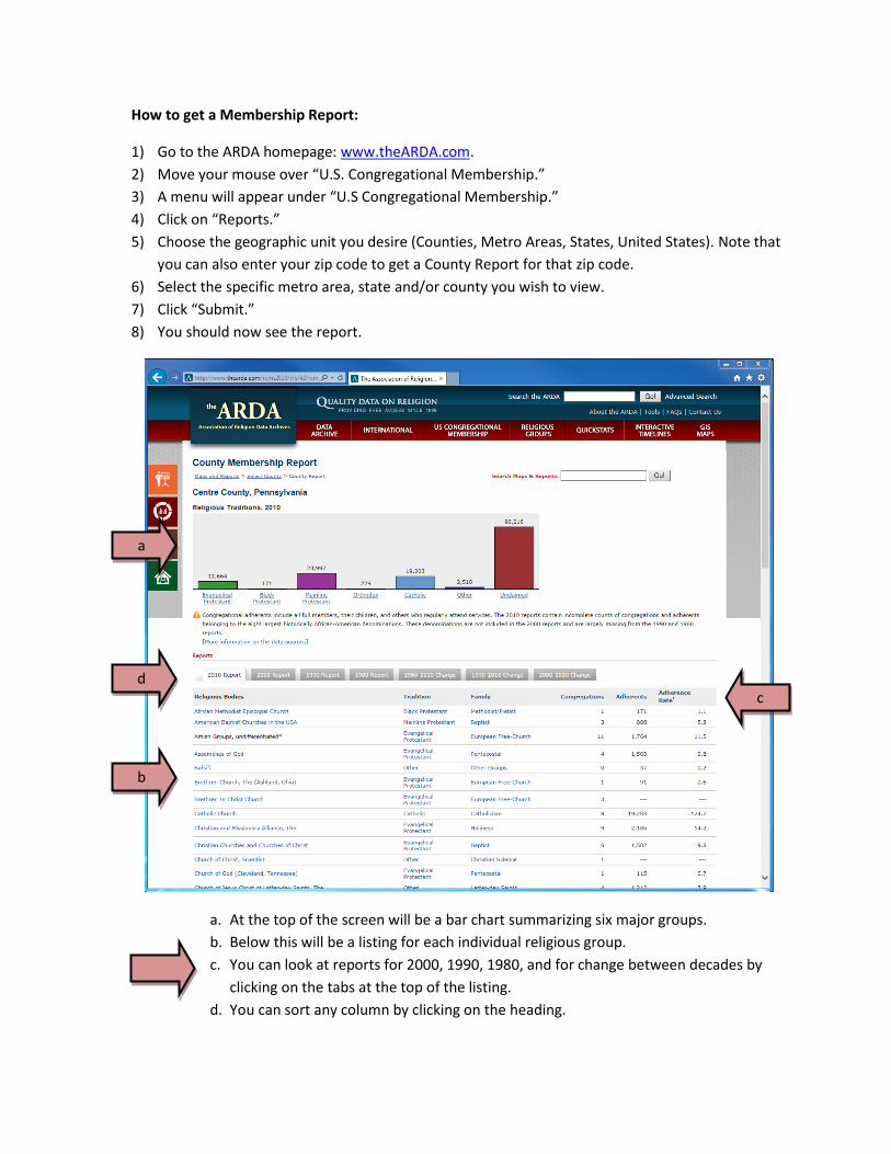
How to get a Membership Report:
1) Go to the ARDA homepage: www.theARDA.com.
2) Move your mouse over “U.S. Congregational Membership.”
3) A menu will appear under “U.S Congregational Membership.”
4) Click on “Reports.”
5) Choose the geographic unit you desire (Counties, Metro Areas, States, United States). Note that
you can also enter your zip code to get a County Report for that zip code.
6) Select the specific metro area, state and/or county you wish to view.
7) Click “Submit.”
8) You should now see the report.
a. At the top of the screen will be a bar chart summarizing six major groups.
b. Below this will be a listing for each individual religious group.
c. You can look at reports for 2000, 1990, 1980, and for change between decades by
clicking on the tabs at the top of the listing.
d. You can sort any column by clicking on the heading.
a
b
d c
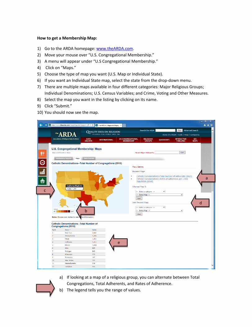
How to get a Membership Map:
1) Go to the ARDA homepage: www.theARDA.com.
2) Move your mouse over “U.S. Congregational Membership.”
3) A menu will appear under “U.S Congregational Membership.”
4) Click on “Maps.”
5) Choose the type of map you want (U.S. Map or Individual State).
6) If you want an Individual State map, select the state from the drop-down menu.
7) There are multiple maps available in four different categories: Major Religious Groups;
Individual Denominations; U.S. Census Variables; and Crime, Voting and Other Measures.
8) Select the map you want in the listing by clicking on its name.
9) Click “Submit.”
10) You should now see the map.
a) If looking at a map of a religious group, you can alternate between Total
Congregations, Total Adherents, and Rates of Adherence.
b) The legend tells you the range of values.
a
b
c
e
d
c) Holding your mouse cursor over an individual state will provide the state’s value and
rank.
d) You can choose another map or add a second map to compare to your first one.
e) Below the map you will see a ranked listing of each state or county.
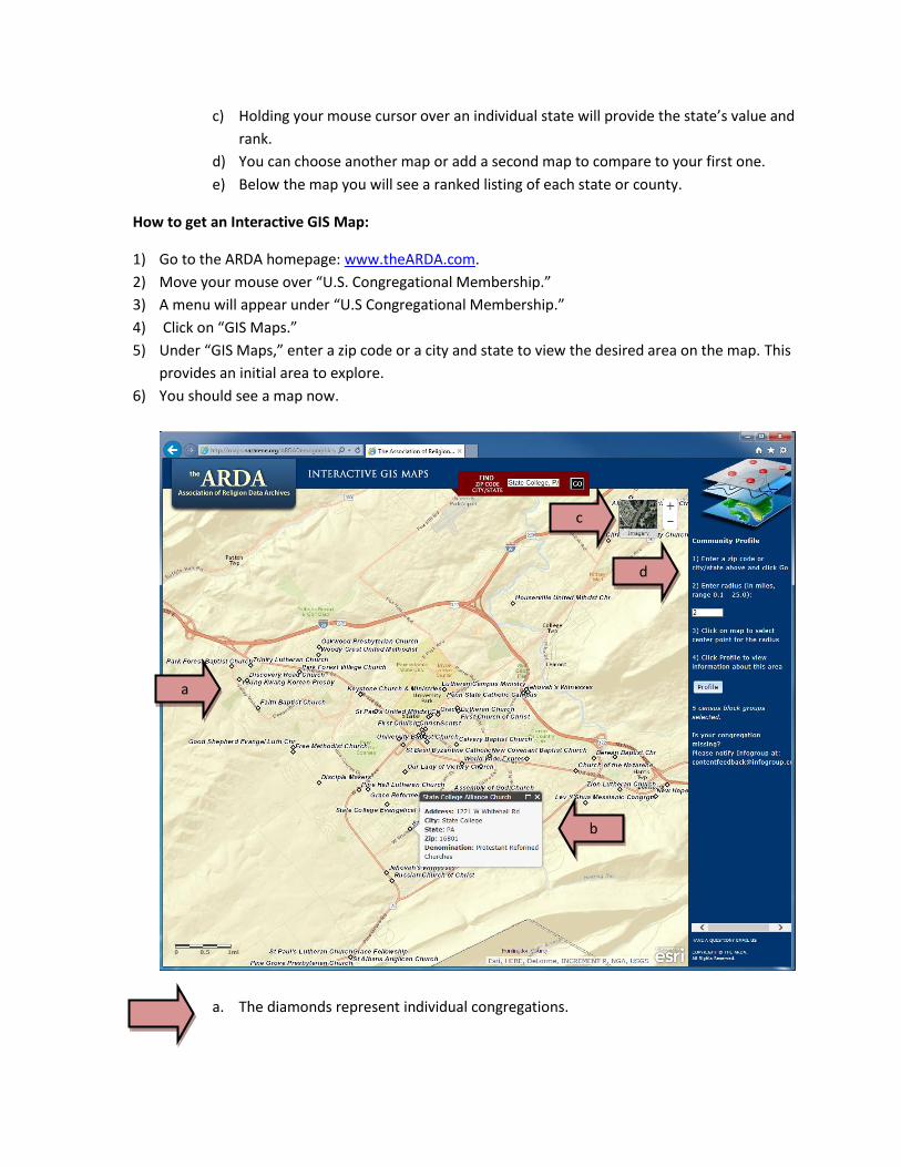
How to get an Interactive GIS Map:
1) Go to the ARDA homepage: www.theARDA.com.
2) Move your mouse over “U.S. Congregational Membership.”
3) A menu will appear under “U.S Congregational Membership.”
4) Click on “GIS Maps.”
5) Under “GIS Maps,” enter a zip code or a city and state to view the desired area on the map. This
provides an initial area to explore.
6) You should see a map now.
a. The diamonds represent individual congregations.
b
a
c
d
b. Holding your mouse cursor over a diamond provides additional details about each
congregation, including its address and denomination.
c. You can zoom in and out, move the map around, and change the map view.
d. You can also build a community profile through the interactive GIS Map
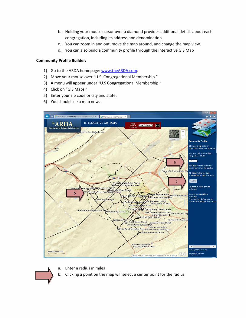
Community Profile Builder:
1) Go to the ARDA homepage: www.theARDA.com.
2) Move your mouse over “U.S. Congregational Membership.”
3) A menu will appear under “U.S Congregational Membership.”
4) Click on “GIS Maps.”
5) Enter your zip code or city and state.
6) You should see a map now.
a. Enter a radius in miles
b. Clicking a point on the map will select a center point for the radius
a
c
b
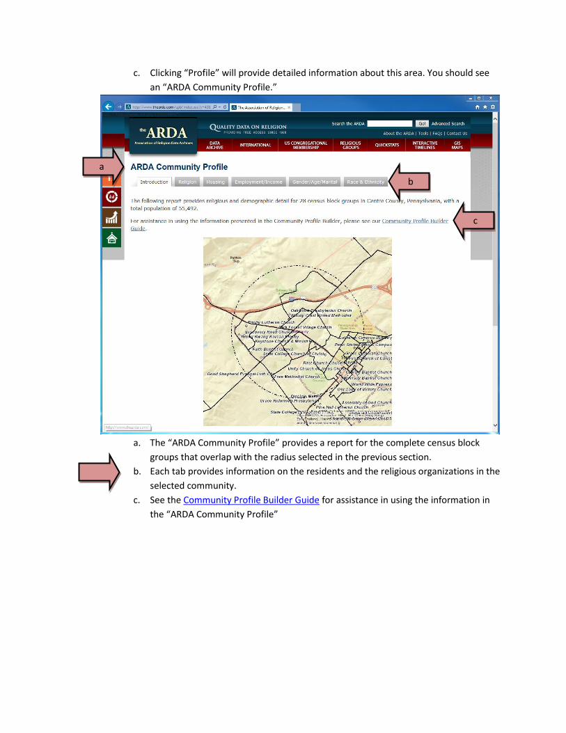
c. Clicking “Profile” will provide detailed information about this area. You should see
an “ARDA Community Profile.”
a. The “ARDA Community Profile” provides a report for the complete census block
groups that overlap with the radius selected in the previous section.
b. Each tab provides information on the residents and the religious organizations in the
selected community.
c. See the Community Profile Builder Guide for assistance in using the information in
the “ARDA Community Profile”
a
c
b