Embed Size (px)
Citation preview
Publish Maps, Data, and Metadata on the Web
ArcIMS®
Key Features
ArcIMS offers the following key features:
• Ease of use—Easily create, design, and manage Web mapping sites.
• GIS Web publishing capabilities—Capabilities include image rendering, feature streaming, data query, and extrac-tion and downloading, geocoding, and metadata services.
• Metadata services—Users can create a central, online metadata repository that allows you to easily publish and browse metadata over the Internet.
• Data integration—Visitors to your site can access your data and simply integrate it with data from many other Internet and local sources. As the ArcIMS user, you can choose to disallow data downloading.
• Multiservice architecture—Multiple map services can be integrated in a single Web application. Supported services include ArcIMS and ArcMap™ image, ArcGIS Server, ArcWebSM Services, and OGC WMS.
• Scalable architecture—ArcIMS is completely scalable whether on your intranet or on the World Wide Web. ArcIMS powers the most demanding sites and services, allowing a large number of concurrent users.
How Is ArcIMS Used?
The following examples illustrate the main application functions of ArcIMS:
Publishing for professional GIS users—Many orga-nizations publish GIS data for GIS professionals both within and outside their bases of operation. Such ArcIMS applications are focused on data sharing between GIS professionals.
Focused application delivery—ArcIMS can be used to deliver GIS to numerous internal users or to external users on the Internet. ArcIMS provides data access and simple, focused applications to users through a Web browser.
Technology for GIS networks—GIS Web publishing with ArcIMS is often the initial step in the implementa-tion of enterprise GIS. GIS organizations publish and deliver GIS data and services to a broad audience, often outside their department or organization. ArcIMS is important for building all the parts of a GIS network and in implementing GIS portals.
An interactive online map of Overland Park, Kansas, shows the public where crime has occurred in the city including tables showing aggregate crime statistics for that area over the past five quarters.
The Asian Institute of Technology’s WebGIS Viewer, built on ArcIMS, shows areas damaged by the December 2004 tsunami. Digital photos that include GPS location data are hyperlinked into the map interface, allowing users to view images of the damage at a particular location.
Australia www.esriaustralia.com.au
Belgium/Luxembourg www.esribelux.com
Bulgaria www.esribulgaria.com
Canada www.esricanada.com
Chile www.esri-chile.com
China (Beijing) www.esrichina-bj.cn
China (Hong Kong) www.esrichina-hk.com
Finland www.esri-finland.com
France www.esrifrance.fr
Germany/Switzerland www.esri-germany.de www.esri-suisse.ch
Hungary www.esrihu.hu
India www.esriindia.com
Indonesia 62-21-527-1023
Italy www.esriitalia.it
Japan www.esrij.com
Korea www.esrikr.co.kr
Malaysia www.esrisa.com.my
Netherlands www.esrinl.com
Poland www.esripolska.com.pl
Portugal www.esri-portugal.pt
No. GS-35F-5086H
Printed in USA
ESRI International Offices
ESRI Regional Offices
Olympia 360-754-4727
St. Louis 636-949-6620
Minneapolis 651-454-0600
Boston 978-777-4543
Washington, D.C. 703-506-9515
Charlotte 704-541-9810
San Antonio 210-499-1044
Denver 303-449-7779
California 909-793-2853 ext. 1-1906
Romania www.esriro.ro
Singapore www.esrisa.com
Spain www.esri-es.com
Sweden www.esri-sweden.com
Thailand www.esrith.com
United Kingdom www.esriuk.com
Venezuela www.esriven.com
104670UBS15M10/06dh
Copyright © 2006 ESRI. All rights reserved. ESRI, ArcIMS, the ESRI globe logo, ArcGIS, ArcCatalog, ADF, the ArcGIS logo, ArcMap, ArcWeb, ArcInfo, @esri.com, and www.esri.com are trademarks, registered trademarks, or service marks of ESRI in the United States, the European Community, or certain other jurisdictions. Other companies and products mentioned herein are trademarks or registered trademarks of their respective trademark owners.
1-800-GIS-XPRT (1-800-447-9778)
www.esri.com
Locate an ESRI value-added reseller near you at
www.esri.com/resellers
Outside the United States, contact your local ESRI distributor. For the number of your distributor, call ESRI at 909-793-2853, ext. 1-1235, or visit our Web site at
www.esri.com/distributors
For More Information
ESRI 380 New York Street Redlands, California 92373-8100 USA
Phone: 909-793-2853Fax: 909-793-5953 E-mail: [email protected]
For more than 35 years, ESRI has
been helping people make better
decisions through management
and analysis of geographic
information. A full-service GIS
company, ESRI offers a framework
for implementing GIS technology
and business logic in any
organization from personal GIS on
the desktop to enterprise-wide GIS
servers (including the Web) and
mobile devices. ESRI® GIS solutions
are flexible and can be customized
to meet the needs of our users.
Philadelphia 610-644-3374
Easily Create and Share Your Web Mapping Application
You can build and customize viewers by using the ArcIMS Web Manager or the ArcIMS Application Developer Framework (ADF™).
Users without developer experience can benefit from the step-by-step workflow in ArcIMS Web Manager, which lets you choose the function-ality and services you want to use in the application. Multiple map ser-vices can be integrated into a single Web application. Once published to the Web, you can still edit the application in ArcIMS Web Manager.
The ADF provides developers with additional flexibility to easily create customized viewers from scratch or edit the output from ArcIMS Web Manager. Two versions of the ADF can be used—one for the Microsoft .NET Framework and one for the Java platform.
On the client side, the custom viewer provides visitors to your Web site with the ability to view high-quality, interactive maps that feature tools including seamless pan, dynamic zoom, MapTips, and keyboard shortcuts.
Maintain Standards and Security
ArcIMS supports Web Map Service (WMS) and Web Feature Service (WFS) capabilities that adhere to Open Geospatial Consortium, Inc. (OGC), specifications. For more information on ESRI’s commitment to interoperability and standards, visit www.esri.com/standards.
To manage the security of your Web site, ArcIMS also supports Secure Hypertext Transfer Protocol and Secure Sockets Layer Protocol. In addi-tion, ArcIMS performs user authentication for map services, allowing you to define which users have access to GIS data.
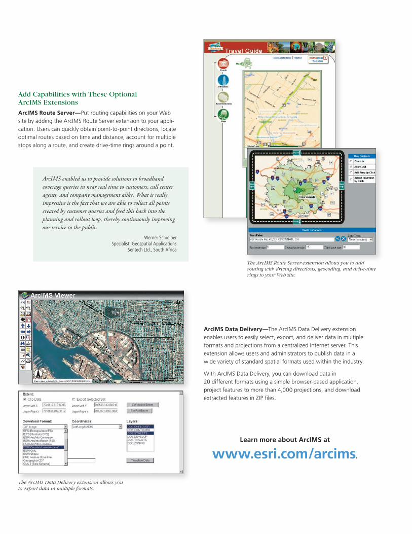
Add Capabilities with These Optional ArcIMS Extensions
ArcIMS Route Server—Put routing capabilities on your Web site by adding the ArcIMS Route Server extension to your appli-cation. Users can quickly obtain point-to-point directions, locate optimal routes based on time and distance, account for multiple stops along a route, and create drive-time rings around a point.
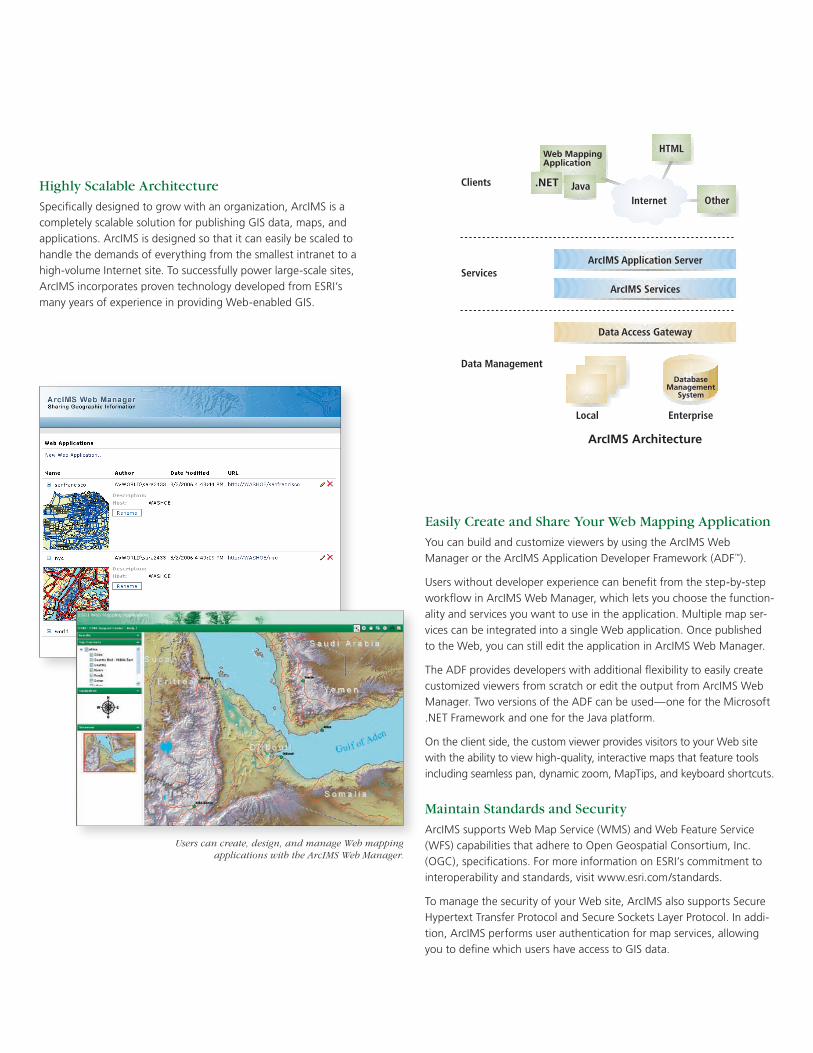
ArcIMS Architecture
DatabaseManagement
System
.NET
Web MappingApplication
Highly Scalable Architecture
Specifically designed to grow with an organization, ArcIMS is a completely scalable solution for publishing GIS data, maps, and applications. ArcIMS is designed so that it can easily be scaled to handle the demands of everything from the smallest intranet to a high-volume Internet site. To successfully power large-scale sites, ArcIMS incorporates proven technology developed from ESRI’s many years of experience in providing Web-enabled GIS.
ArcIMS Data Delivery—The ArcIMS Data Delivery extension enables users to easily select, export, and deliver data in multiple formats and projections from a centralized Internet server. This extension allows users and administrators to publish data in a wide variety of standard spatial formats used within the industry.
With ArcIMS Data Delivery, you can download data in 20 different formats using a simple browser-based application, project features to more than 4,000 projections, and download extracted features in ZIP files.
ArcIMS enabled us to provide solutions to broadband coverage queries in near real time to customers, call center agents, and company management alike. What is really impressive is the fact that we are able to collect all points created by customer queries and feed this back into the planning and rollout loop, thereby continuously improving our service to the public.
Werner SchreiberSpecialist, Geospatial Applications
Sentech Ltd., South Africa
Learn more about ArcIMS at
www.esri.com/arcims.
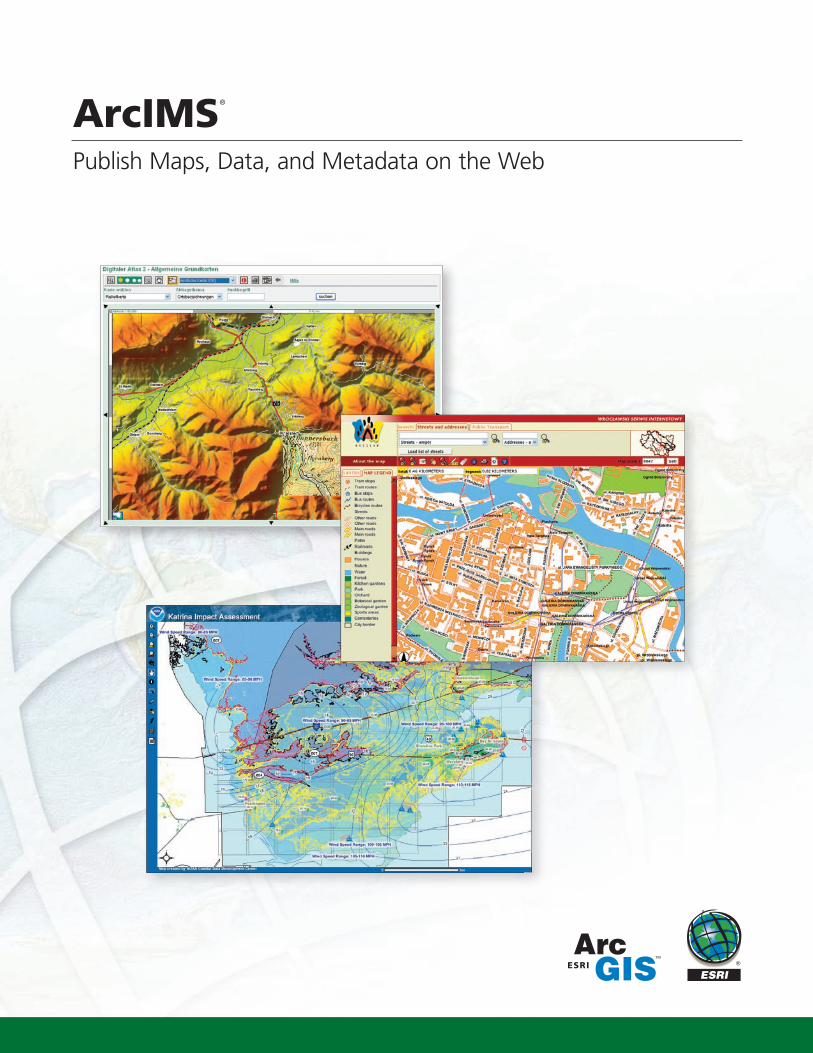
What Is ArcIMS?
ArcIMS® delivers dynamic maps and geographic information system (GIS) data and services via the Web. It provides a highly scalable framework for GIS Web publishing that meets the needs of corpo-rate intranets and the demands of worldwide Inter-net access. ArcIMS services can be used by a wide range of clients including custom Web applications, ArcGIS® Desktop, and mobile and wireless devices. Using ArcIMS, city and local governments, busi-nesses, and other organizations worldwide publish, discover, and share geospatial information.
ArcIMS®
Publish Maps, Data, and Metadata on the Web
The majority of the benefits from using ArcIMS stem from the use of a single basemap to which all GIS staffs’ geographic data can be linked. We have also built an online property information system based on ArcIMS that the public can access to get detailed county property information at their convenience.
Louis K. MarionGIS Director
Geauga County Auditor’s Office, Ohio, USA
Our award-winning CLAIMaps site, built on ArcIMS, has helped make Ontario one of the most favored juris-dictions in the world for exploration investment. Users can view crisp, high-quality images and download daily updated mining land maps, which allows potential investors to make more informed investment decisions.
Brian Berdusco GIS Project Manager
Ministry of Northern Development and Mines, Ontario, Canada
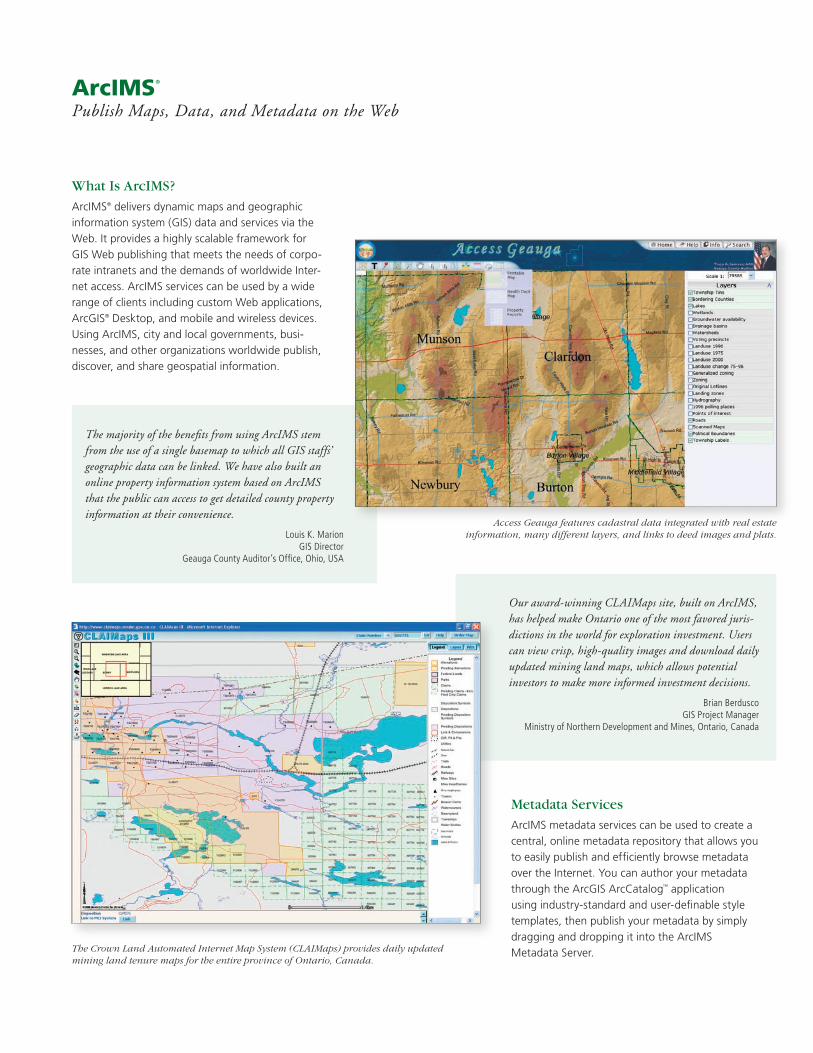
Users can create, design, and manage Web mapping applications with the ArcIMS Web Manager.
The ArcIMS Data Delivery extension allows you to export data in multiple formats.
The ArcIMS Route Server extension allows you to add routing with driving directions, geocoding, and drive-time rings to your Web site.
Access Geauga features cadastral data integrated with real estate information, many different layers, and links to deed images and plats.
The Crown Land Automated Internet Map System (CLAIMaps) provides daily updated mining land tenure maps for the entire province of Ontario, Canada.
Metadata Services
ArcIMS metadata services can be used to create a central, online metadata repository that allows you to easily publish and efficiently browse metadata over the Internet. You can author your metadata through the ArcGIS ArcCatalog™ application using industry-standard and user-definable style templates, then publish your metadata by simply dragging and dropping it into the ArcIMS Metadata Server.
Easily Create and Share Your Web Mapping Application
You can build and customize viewers by using the ArcIMS Web Manager or the ArcIMS Application Developer Framework (ADF™).
Users without developer experience can benefit from the step-by-step workflow in ArcIMS Web Manager, which lets you choose the function-ality and services you want to use in the application. Multiple map ser-vices can be integrated into a single Web application. Once published to the Web, you can still edit the application in ArcIMS Web Manager.
The ADF provides developers with additional flexibility to easily create customized viewers from scratch or edit the output from ArcIMS Web Manager. Two versions of the ADF can be used—one for the Microsoft .NET Framework and one for the Java platform.
On the client side, the custom viewer provides visitors to your Web site with the ability to view high-quality, interactive maps that feature tools including seamless pan, dynamic zoom, MapTips, and keyboard shortcuts.
Maintain Standards and Security
ArcIMS supports Web Map Service (WMS) and Web Feature Service (WFS) capabilities that adhere to Open Geospatial Consortium, Inc. (OGC), specifications. For more information on ESRI’s commitment to interoperability and standards, visit www.esri.com/standards.
To manage the security of your Web site, ArcIMS also supports Secure Hypertext Transfer Protocol and Secure Sockets Layer Protocol. In addi-tion, ArcIMS performs user authentication for map services, allowing you to define which users have access to GIS data.
Add Capabilities with These Optional ArcIMS Extensions
ArcIMS Route Server—Put routing capabilities on your Web site by adding the ArcIMS Route Server extension to your appli-cation. Users can quickly obtain point-to-point directions, locate optimal routes based on time and distance, account for multiple stops along a route, and create drive-time rings around a point.
ArcIMS Architecture
DatabaseManagement
System
.NET
Web MappingApplication
Highly Scalable Architecture
Specifically designed to grow with an organization, ArcIMS is a completely scalable solution for publishing GIS data, maps, and applications. ArcIMS is designed so that it can easily be scaled to handle the demands of everything from the smallest intranet to a high-volume Internet site. To successfully power large-scale sites, ArcIMS incorporates proven technology developed from ESRI’s many years of experience in providing Web-enabled GIS.
ArcIMS Data Delivery—The ArcIMS Data Delivery extension enables users to easily select, export, and deliver data in multiple formats and projections from a centralized Internet server. This extension allows users and administrators to publish data in a wide variety of standard spatial formats used within the industry.
With ArcIMS Data Delivery, you can download data in 20 different formats using a simple browser-based application, project features to more than 4,000 projections, and download extracted features in ZIP files.
ArcIMS enabled us to provide solutions to broadband coverage queries in near real time to customers, call center agents, and company management alike. What is really impressive is the fact that we are able to collect all points created by customer queries and feed this back into the planning and rollout loop, thereby continuously improving our service to the public.
Werner SchreiberSpecialist, Geospatial Applications
Sentech Ltd., South Africa
Learn more about ArcIMS at
www.esri.com/arcims.
What Is ArcIMS?
ArcIMS® delivers dynamic maps and geographic information system (GIS) data and services via the Web. It provides a highly scalable framework for GIS Web publishing that meets the needs of corpo-rate intranets and the demands of worldwide Inter-net access. ArcIMS services can be used by a wide range of clients including custom Web applications, ArcGIS® Desktop, and mobile and wireless devices. Using ArcIMS, city and local governments, busi-nesses, and other organizations worldwide publish, discover, and share geospatial information.
ArcIMS®
Publish Maps, Data, and Metadata on the Web
The majority of the benefits from using ArcIMS stem from the use of a single basemap to which all GIS staffs’ geographic data can be linked. We have also built an online property information system based on ArcIMS that the public can access to get detailed county property information at their convenience.
Louis K. MarionGIS Director
Geauga County Auditor’s Office, Ohio, USA
Our award-winning CLAIMaps site, built on ArcIMS, has helped make Ontario one of the most favored juris-dictions in the world for exploration investment. Users can view crisp, high-quality images and download daily updated mining land maps, which allows potential investors to make more informed investment decisions.
Brian Berdusco GIS Project Manager
Ministry of Northern Development and Mines, Ontario, Canada
Users can create, design, and manage Web mapping applications with the ArcIMS Web Manager.
The ArcIMS Data Delivery extension allows you to export data in multiple formats.
The ArcIMS Route Server extension allows you to add routing with driving directions, geocoding, and drive-time rings to your Web site.
Access Geauga features cadastral data integrated with real estate information, many different layers, and links to deed images and plats.
The Crown Land Automated Internet Map System (CLAIMaps) provides daily updated mining land tenure maps for the entire province of Ontario, Canada.
Metadata Services
ArcIMS metadata services can be used to create a central, online metadata repository that allows you to easily publish and efficiently browse metadata over the Internet. You can author your metadata through the ArcGIS ArcCatalog™ application using industry-standard and user-definable style templates, then publish your metadata by simply dragging and dropping it into the ArcIMS Metadata Server.
Publish Maps, Data, and Metadata on the Web
ArcIMS®
Key Features
ArcIMS offers the following key features:
• Ease of use—Easily create, design, and manage Web mapping sites.
• GIS Web publishing capabilities—Capabilities include image rendering, feature streaming, data query, and extrac-tion and downloading, geocoding, and metadata services.
• Metadata services—Users can create a central, online metadata repository that allows you to easily publish and browse metadata over the Internet.
• Data integration—Visitors to your site can access your data and simply integrate it with data from many other Internet and local sources. As the ArcIMS user, you can choose to disallow data downloading.
• Multiservice architecture—Multiple map services can be integrated in a single Web application. Supported services include ArcIMS and ArcMap™ image, ArcGIS Server, ArcWebSM Services, and OGC WMS.
• Scalable architecture—ArcIMS is completely scalable whether on your intranet or on the World Wide Web. ArcIMS powers the most demanding sites and services, allowing a large number of concurrent users.
How Is ArcIMS Used?
The following examples illustrate the main application functions of ArcIMS:
Publishing for professional GIS users—Many orga-nizations publish GIS data for GIS professionals both within and outside their bases of operation. Such ArcIMS applications are focused on data sharing between GIS professionals.
Focused application delivery—ArcIMS can be used to deliver GIS to numerous internal users or to external users on the Internet. ArcIMS provides data access and simple, focused applications to users through a Web browser.
Technology for GIS networks—GIS Web publishing with ArcIMS is often the initial step in the implementa-tion of enterprise GIS. GIS organizations publish and deliver GIS data and services to a broad audience, often outside their department or organization. ArcIMS is important for building all the parts of a GIS network and in implementing GIS portals.
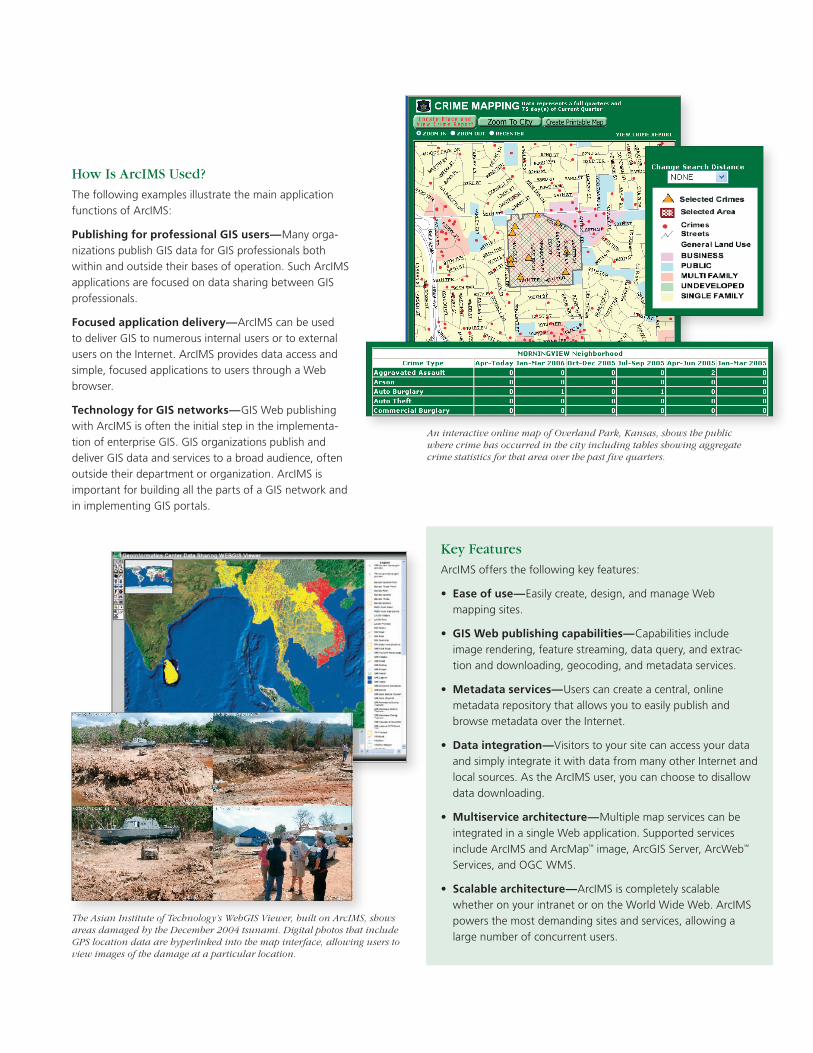
An interactive online map of Overland Park, Kansas, shows the public where crime has occurred in the city including tables showing aggregate crime statistics for that area over the past five quarters.
The Asian Institute of Technology’s WebGIS Viewer, built on ArcIMS, shows areas damaged by the December 2004 tsunami. Digital photos that include GPS location data are hyperlinked into the map interface, allowing users to view images of the damage at a particular location.
Australia www.esriaustralia.com.au
Belgium/Luxembourg www.esribelux.com
Bulgaria www.esribulgaria.com
Canada www.esricanada.com
Chile www.esri-chile.com
China (Beijing) www.esrichina-bj.cn
China (Hong Kong) www.esrichina-hk.com
Finland www.esri-finland.com
France www.esrifrance.fr
Germany/Switzerland www.esri-germany.de www.esri-suisse.ch
Hungary www.esrihu.hu
India www.esriindia.com
Indonesia 62-21-527-1023
Italy www.esriitalia.it
Japan www.esrij.com
Korea www.esrikr.co.kr
Malaysia www.esrisa.com.my
Netherlands www.esrinl.com
Poland www.esripolska.com.pl
Portugal www.esri-portugal.pt
No. GS-35F-5086H
Printed in USA
ESRI International Offices
ESRI Regional Offices
Olympia 360-754-4727
St. Louis 636-949-6620
Minneapolis 651-454-0600
Boston 978-777-4543
Washington, D.C. 703-506-9515
Charlotte 704-541-9810
San Antonio 210-499-1044
Denver 303-449-7779
California 909-793-2853 ext. 1-1906
Romania www.esriro.ro
Singapore www.esrisa.com
Spain www.esri-es.com
Sweden www.esri-sweden.com
Thailand www.esrith.com
United Kingdom www.esriuk.com
Venezuela www.esriven.com
104670UBS15M10/06dh
Copyright © 2006 ESRI. All rights reserved. ESRI, ArcIMS, the ESRI globe logo, ArcGIS, ArcCatalog, ADF, the ArcGIS logo, ArcMap, ArcWeb, ArcInfo, @esri.com, and www.esri.com are trademarks, registered trademarks, or service marks of ESRI in the United States, the European Community, or certain other jurisdictions. Other companies and products mentioned herein are trademarks or registered trademarks of their respective trademark owners.
1-800-GIS-XPRT (1-800-447-9778)
www.esri.com
Locate an ESRI value-added reseller near you at
www.esri.com/resellers
Outside the United States, contact your local ESRI distributor. For the number of your distributor, call ESRI at 909-793-2853, ext. 1-1235, or visit our Web site at
www.esri.com/distributors
For More Information
ESRI 380 New York Street Redlands, California 92373-8100 USA
Phone: 909-793-2853Fax: 909-793-5953 E-mail: [email protected]
For more than 35 years, ESRI has
been helping people make better
decisions through management
and analysis of geographic
information. A full-service GIS
company, ESRI offers a framework
for implementing GIS technology
and business logic in any
organization from personal GIS on
the desktop to enterprise-wide GIS
servers (including the Web) and
mobile devices. ESRI® GIS solutions
are flexible and can be customized
to meet the needs of our users.
Philadelphia 610-644-3374
Publish Maps, Data, and Metadata on the Web
ArcIMS®
Key Features
ArcIMS offers the following key features:
• Ease of use—Easily create, design, and manage Web mapping sites.
• GIS Web publishing capabilities—Capabilities include image rendering, feature streaming, data query, and extrac-tion and downloading, geocoding, and metadata services.
• Metadata services—Users can create a central, online metadata repository that allows you to easily publish and browse metadata over the Internet.
• Data integration—Visitors to your site can access your data and simply integrate it with data from many other Internet and local sources. As the ArcIMS user, you can choose to disallow data downloading.
• Multiservice architecture—Multiple map services can be integrated in a single Web application. Supported services include ArcIMS and ArcMap™ image, ArcGIS Server, ArcWebSM Services, and OGC WMS.
• Scalable architecture—ArcIMS is completely scalable whether on your intranet or on the World Wide Web. ArcIMS powers the most demanding sites and services, allowing a large number of concurrent users.
How Is ArcIMS Used?
The following examples illustrate the main application functions of ArcIMS:
Publishing for professional GIS users—Many orga-nizations publish GIS data for GIS professionals both within and outside their bases of operation. Such ArcIMS applications are focused on data sharing between GIS professionals.
Focused application delivery—ArcIMS can be used to deliver GIS to numerous internal users or to external users on the Internet. ArcIMS provides data access and simple, focused applications to users through a Web browser.
Technology for GIS networks—GIS Web publishing with ArcIMS is often the initial step in the implementa-tion of enterprise GIS. GIS organizations publish and deliver GIS data and services to a broad audience, often outside their department or organization. ArcIMS is important for building all the parts of a GIS network and in implementing GIS portals.
An interactive online map of Overland Park, Kansas, shows the public where crime has occurred in the city including tables showing aggregate crime statistics for that area over the past five quarters.
The Asian Institute of Technology’s WebGIS Viewer, built on ArcIMS, shows areas damaged by the December 2004 tsunami. Digital photos that include GPS location data are hyperlinked into the map interface, allowing users to view images of the damage at a particular location.
Australia www.esriaustralia.com.au
Belgium/Luxembourg www.esribelux.com
Bulgaria www.esribulgaria.com
Canada www.esricanada.com
Chile www.esri-chile.com
China (Beijing) www.esrichina-bj.cn
China (Hong Kong) www.esrichina-hk.com
Finland www.esri-finland.com
France www.esrifrance.fr
Germany/Switzerland www.esri-germany.de www.esri-suisse.ch
Hungary www.esrihu.hu
India www.esriindia.com
Indonesia 62-21-527-1023
Italy www.esriitalia.it
Japan www.esrij.com
Korea www.esrikr.co.kr
Malaysia www.esrisa.com.my
Netherlands www.esrinl.com
Poland www.esripolska.com.pl
Portugal www.esri-portugal.pt
No. GS-35F-5086H
Printed in USA
ESRI International Offices
ESRI Regional Offices
Olympia 360-754-4727
St. Louis 636-949-6620
Minneapolis 651-454-0600
Boston 978-777-4543
Washington, D.C. 703-506-9515
Charlotte 704-541-9810
San Antonio 210-499-1044
Denver 303-449-7779
California 909-793-2853 ext. 1-1906
Romania www.esriro.ro
Singapore www.esrisa.com
Spain www.esri-es.com
Sweden www.esri-sweden.com
Thailand www.esrith.com
United Kingdom www.esriuk.com
Venezuela www.esriven.com
104670UBS15M10/06dh
Copyright © 2006 ESRI. All rights reserved. ESRI, ArcIMS, the ESRI globe logo, ArcGIS, ArcCatalog, ADF, the ArcGIS logo, ArcMap, ArcWeb, ArcInfo, @esri.com, and www.esri.com are trademarks, registered trademarks, or service marks of ESRI in the United States, the European Community, or certain other jurisdictions. Other companies and products mentioned herein are trademarks or registered trademarks of their respective trademark owners.
1-800-GIS-XPRT (1-800-447-9778)
www.esri.com
Locate an ESRI value-added reseller near you at
www.esri.com/resellers
Outside the United States, contact your local ESRI distributor. For the number of your distributor, call ESRI at 909-793-2853, ext. 1-1235, or visit our Web site at
www.esri.com/distributors
For More Information
ESRI 380 New York Street Redlands, California 92373-8100 USA
Phone: 909-793-2853Fax: 909-793-5953 E-mail: [email protected]
For more than 35 years, ESRI has
been helping people make better
decisions through management
and analysis of geographic
information. A full-service GIS
company, ESRI offers a framework
for implementing GIS technology
and business logic in any
organization from personal GIS on
the desktop to enterprise-wide GIS
servers (including the Web) and
mobile devices. ESRI® GIS solutions
are flexible and can be customized
to meet the needs of our users.
Philadelphia 610-644-3374