Embed Size (px)
Citation preview
1
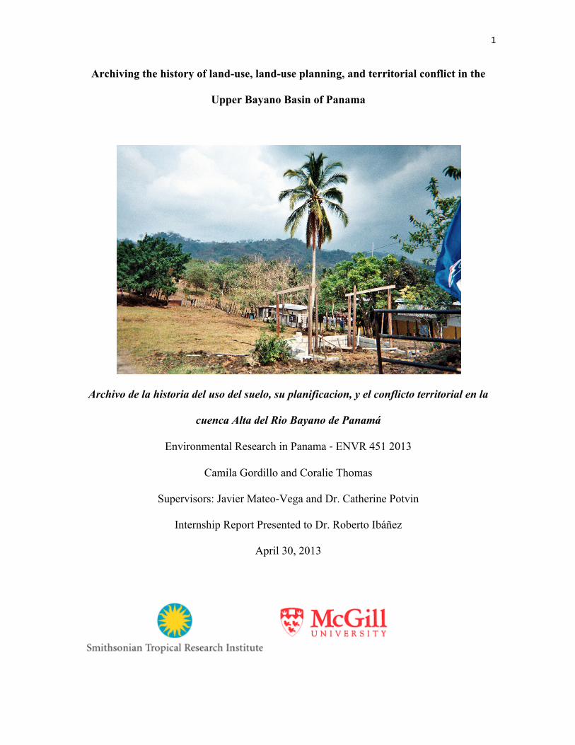
Archiving the history of land-use, land-use planning, and territorial conflict in the
Upper Bayano Basin of Panama
Archivo de la historia del uso del suelo, su planificacion, y el conflicto territorial en la
cuenca Alta del Rio Bayano de Panamá
Environmental Research in Panama -‐ ENVR 451 2013
Camila Gordillo and Coralie Thomas
Supervisors: Javier Mateo-Vega and Dr. Catherine Potvin
Internship Report Presented to Dr. Roberto Ibáñez
April 30, 2013

2
Acknowledgements:
We would like to thank our supervisor, Javier Mateo-Vega of the Smithsonian
Tropical Research Institute and McGill University for all of his help and guidance with this
project. We appreciated his positive energy and desire to always be available for us
throughout the process. We would also like to thank Dr. Francisco Herrera of the
University of Panama for all of the time he took to meet with us and the ideas he gave us.
Other people who provided marvelous help to us include the librarians at ANAM, Daviken
Studniki-Gizbert, Bonarge Pacheco, Omaira Casama, Laura´s family en Ipetí-Emberá,
Cassiano Cano and Dionis Cano de APAP, Carlos Melgarejo de ANAM. Finally, we would
like to thank Dr. Ibanez and Victor Frankel for their help supervising this course.
Host Institution:
Our project was done in collaboration with the Smithsonian Tropical Research
Institute located in Panama City, Panama. The Smithsonian Tropical Research Institute
(STRI) was founded in 1923 in order to study and understand biological diversity in the
Neotropics. STRI currently has four main research stations throughout Panama and hosts
900 visiting researchers and students per year. Our project was done under the supervision
of Javier Mateo-Vega, PhD Candidate in the Neotropical Environment Option at McGill
University and Dr. Catherine Potvin, McGill University professor and Staff Scientist at
STRI. The two researchers are working on a land-use planning project in the Upper Bayano
Basin in Eastern Panama, which was the area of study for our research project.

3
Address:
Javier Mateo-Vega
Smithsonian Tropical Research Institute
Roosevelt Avenue
Tupper Building
Balboa, Ancón
Panamá, República de Panamá
Local Mailing Address:
Apartado Postal 0843-03092
Panamá, República de Panamá
Time Allocation (1 day = 8 hours):
Number of days spent conducting research in field = 5
Number of days spent collecting documents and conducting interviews in Panama City =
12
Additional days spent working on project = 26
Total number of days = 43

4
Table of Contents
1. Acknowledgements
2. Host Institution
3. Project Summary 3
1.1 Executive Summary
1.2 Resumen Ejecutivo
4. Introduction
5. Objective
6. Methodology
6.1 Part I - Collection of information
6.1.1 - Exploratory Interviews
6.1.2 - Literature Review
6.1.3 - Library and Public Office Visits
6.1.4 - Community Visits
6.1.5 - Semi-structured interviews
6.2 Part II - Archiving of information
6.2.1 - Creation of Archive
6.2.2 - Product for Host Institution
7. Temporal Analysis of Land-use Planning
7.1 Introduction
7.2 Eastern Panama under the spotlight, but not yet a star: 1962 to 1969
7.3 Dilemma between national ideas of progress and responsibility towards all
sectors of society: 1968 to 1981
7.4 Opportunism under Noriega: changes in land use from 1982 to 1989

5
7.5 The invasion of land use planning in 1989 to 1994
7.6 Neoliberal multiculturalism and environmentalism from 1995 to 2012
8. Conclusion
9. Appendices
8.1 Appendix A - Annotated Bibliography
8.2 Appendix B - Interview Consent Form
Executive Summary:
The Upper Bayano Basin is located in Eastern Panama and encompasses two
Emberá tierra colectivas, one Kuna comarca, and a multitude of campesino cattle ranches
and farms. The region has a complex history significantly influenced by the construction of
the Bayano Hydroelectic Dam in the 1970s, the migration of campesinos from Los Santos
to the Bayano in the 1970s and 1980s, and the large amount of economic development and
land-use planning projects undertaken in the region. There has been a history of conflict
between the two indigenous groups and the campesinos as the campesinos have been
known to invade indigenous land to deforest areas and begin cattle ranches. In 2013,
Catherine Potvin and Javier Mateo-Vega of the Smithsonian Tropical Research Institute
(STRI) and McGill University in collaboration with the three groups of people in the
region, began a project to create a land-use management plan for the entire region in order
to effectively use the land and resolve the conflicts between the three groups.
Our objective at the outset of this project was to find, digitize, summarize, and
categorize all documents pertaining to land-use, land-use planning and conflict in the Upper
Bayano Region of Panama in order to reconstruct the history of the region and help guide
the future of land-use planning in the region. Our research was targeted at helping Dr.

6
Potvin and Javier Mateo-Vega gain a better understanding of the history of the land-use
planning in the region in order to avoid the mistakes made in the past.
In this report we start by discussing our research methodology to help guide others
who may conduct similar research in the future. Our methodology included two distinct
parts. Part I was the collection of information and it was comprised of informal interviews,
a literature review, visits to libraries, public offices, and the representatives of the three
communities, and semi-structured interviews with community members. Part II was the
systematization of the collected information which included digitizing, summarizing, and
classifying collected information.
We next discuss the results of our research and the product we created for our host
institution. Our product for our host institution includes (1) a database of references,
documents, articles, and laws that have all been summarized, categorized, and labeled for
relevance to the topic of land-use, land-use planning, or conflicts in the region; (2) an
archive organized by type of document and where the documents were found and; (3) an
annotated bibliography of all references relevant to the topic (see Annex A). We discuss
what type of information is available for future researchers and where there are gaps in
information either from lack of research or because documents have been lost over time.
Finally, we present a temporal analysis of land-use planning in the region based on
the results of our research. We identify the major drivers of land-use planning changes
during the five major time periods of: (1) Pre-Bayano Hydroelectic Dam Construction,
1962-1969; (2) During and immediately following the construction of the Bayano Dam,
1968-1981; (3) Under the Norriega government,1982-1989; (4) During an increase in land-
use planning, 1989-1994 and (5) The most recent influences of land-use planning, 1995-

7
2012. We conclude that there is the need for a more neutral agent monitoring land use
planning in the Bayano region, given its biodiversity and cultural importance.
The lessons learned from looking at the history of land use planning in the Upper Bayano
Basin is intended to help guide the future of land use planning in the region.
Resumen ejecutivo:
La cuenca del Alto Bayano se encuentra en Panamá Este y abarca dos TColectivas
Emberá tierra, una comarca Kuna, y una multitud de campesinos ranchos y granjas
ganaderas. La región tiene una historia compleja influenciada significativamente por la
construcción de la Presa Hidroeléctrica Bayano en la década de 1970, la migración de los
campesinos de Los Santos de la Bayano en los años 1970 y 1980, y la gran cantidad de
proyectos de ordenación del territorio y el desarrollo económico emprendido en la región a
través del tiempo. Ha habido una historia de conflicto entre los dos grupos indígenas y los
campesinos. Este ultimo grupo como ha sido conocido por invadir tierras indígenas para
deforestar áreas y comenzar haciendas ganaderas. En 2013, Catherine Potvin y Javier
Mateo-Vega, del Instituto Smithsonian de Investigaciones Tropicales (STRI) y de la
Universidad McGill, en colaboración con los tres grupos de personas en la región, iniciaron
un proyecto de creación de un plan de ordenamiento territorial para toda la región con el fin
de utilizar eficazmente la tierra y resolver los conflictos entre los tres grupos.
Nuestro objetivo con este proyecto era encontrar, digitalizar, resumir y clasificar
todos los documentos relacionados con el uso del suelo, la ordenación del territorio y el
conflicto en la región del Alto Bayano de Panamá con el fin de reconstruir la historia de la
región y ayudar a orientar el futuro de la planificación del uso del suelo en la región.
Nuestra investigación se dirige a ayudar a Dr. Potvin y Javier Mateo-Vega a obtener una

8
mejor comprensión de la historia de la planificación del uso del suelo en la región con el fin
de evitar los errores cometidos en el pasado.
En este informe, empezamos por discutir la metodología de la investigación para
ayudar a guiar a otras personas que puedan llevar a cabo investigaciones similares en el
futuro. Nuestra metodología incluye dos partes bien diferenciadas. Parte I fue la
recopilación de información y que estaba compuesta por entrevistas informales, una
revisión de la literatura, visitas a bibliotecas, oficinas públicas, y los representantes de las
tres comunidades, y entrevistas semi-estructuradas con miembros de la comunidad. Parte II
fue la sistematización de la información recopilada, que incluye la digitalización, resumir y
clasificar la información recogida.
A continuación analizaremos los resultados de nuestra investigación y el producto que
hemos creado para nuestra institución anfitriona. Nuestro producto de nuestra institución
anfitriona incluye (1) una base de datos de referencias, documentos, artículos y leyes, que
han sido resumidos, categorizados y etiquetado para su relevancia con el tema del uso de la
tierra, la planificación del uso de la tierra, o los conflictos en el región, (2) un archivo
organizado por tipo de documento y donde se encontraron los documentos, y (3) una
bibliografía anotada de todas las referencias pertinentes al tema (véase el Anexo A). Se
discute qué tipo de información está disponible para los futuros investigadores y las lagunas
en la información ya sea por la falta de investigación o porque los documentos se han
perdido con el tiempo.
Por último, se presenta un análisis temporal de la planificación del uso del suelo en
la región sobre la base de los resultados de nuestra investigación. Identificamos los
principales impulsores de los cambios en la planificacion del uso del suelo durante los
cinco grandes períodos de tiempo de: (1) Pre-Hidroeléctrica Bayano construcción de presas,

9
1962-1969, (2) Durante e inmediatamente después de la construcción de la represa de
Bayano, 1968-1981 , (3) Bajo el gobierno Norriega ,1982-1989, (4) Durante un aumento en
la planificación del uso del suelo, 1989-1994 y (5) Las influencias más recientes de uso de
la tierra planning 1995-2012. Llegamos a la conclusión de que con areas importantes en
biodiversidad y diversidad cultural como el Bayano, es importante tener un monitoreo
neutro sobre el uso del suelo.
Las lecciones aprendidas al ver la historia de la planificación del uso del suelo en la cuenca
del Alto Bayano está diseñado para ayudar a guiar el futuro de la planificación del uso del
suelo en la región.
Introduction:
The Upper Bayano Basin is located in the eastern edge of the province of Panama
beginning at the Bayano Lake to past the town of Tortí and falling between the two
cordilleras (see Figure 1). It is home to three main groups of people; the Kuna, who have
occupied the area since before the arrival of the Spanish, the Emberá, who migrated there
initially from further East in the Darien during the 1950s but also had two later waves of
migration (Wali 1989); and the campesino farmers, some of whom occupied the area before
the 1970s but the majority of whom migrated to the area from Los Santos in Western
Panama during the 1970s and 1980s (Partridge 1984) ). The region has a unique and
complex history shaped by various waves of migrations, the construction of the Bayano

10
Hydroelectric Dam during the 1970s, the influence of national and international
development programs, and conflicts between the three groups over issues of territory.
Figure 1: The Upper Bayano Basin demarcated in yellow
From 1972 to 1976, the Bayano Hydroelectric Dam was built under the Torrijos
regime with the hope of decreasing Panama’s reliance on external sources of energy and
increasing Panama’s economic sovereignty versus the United State’s control over the Canal
Zone (Wali 1989) (Heckadon-Moreno 2013). The construction of the dam flooded a large
amount of area and caused the displacement in some form of all three groups of people.
Initially, all three groups were going to be resettled outside of the region, however, the
actual resettlement ended quite differently. Both of the indigenous groups were permitted to
remain within the area because of their alleged ecologically-minded agriculture practices
that posed no threat to the integrity of the Bayano Lake and Hydroelectric Dam. The Kuna
resettled along the coast of the Bayano Lake and the Emberá further down along the Pan-
American Highway. The campesinos, however, were all resettled outside of the region
because their cattle ranching practices were though to pose a threat to the lake and the dam.

11
The resettlement was tied to issues of land demarcation and compensation promises for the
indigenous groups that have still not been solved to this day (Wali 1989). Despite the
renegotiations of the resettlement, the resettlement and the plans for the management of the
region following the construction of the dam were originally thought to be quite acceptable.
A team of social scientists that had social and ecological concerns in mind created the
resettlement and management plans for the region.
However, following the completion of the dam the political climate of Panama changed,
placing new pressures on General Torrijos and resulting in significant consequences for the
Bayano region. The economic exploitation of the area became under control of the Bayano
Corporation, a regional semi-autonomous authority that permitted the migration of the
campesinos both implicitly initially by not penalizing the migrations and later explicitly by
granting “derechos possesorios,” or land rights granted because of occupation of the land
(Wali 1989). The Bayano Corporation encouraged the cattle ranching practices of the
campesinos and the logging of timber extraction companies because both promised
economic development for Panama (Wali 1989). However, both of these actions threatened
the lands of indigenous peoples. As campesinos moved into the area they often invaded the
lands of indigenous peoples, deforesting their land and creating cattle ranches, thus creating
an area of conflict between the two groups. These invasions and conflicts have continued
since the 1970s amidst efforts to solve them, continued timber extraction, reforestation
efforts, and various other development programs for the region.
Throughout the 1990s and 2000s the region experienced increased economic activity and as
well as the involvement of various international and national development projects. During
this time there was an effort to settle the differences between the three groups in a program
called “The Mesas de Concertacion” the reconstruction of which was the subject of a
12
previous Panama Field Study Semester Report by Megan Smeaton and Jessie Rivera-Fagan
in 2010. The region has also been the subject of development projects including the Darien
Sustainable Development Project (1998) and considered as a testing ground for various
REDD+ projects (Potvin 2007) (COONAPIP 2009). In 1998 the Louis Berger Study,
funded by ANAM, University of Panama, Delca Consultores, and Louis Berger
International, undertook a comprehensive study of the region and proposed a land-use
management plan that was never carried out.
Recently, Dr. Catherine Potvin and Javier Mateo-Vega of the Smithsonian Tropical
Research Institute and McGill University began a three-year project to create a land-use
management plan for the entire region. The project follows extensive work in the region by
both researchers. The initial three-year plan includes capacity building and participatory
mapping in the first year, the development of land-use plans for each group in the second
year, and the collaboration between all three groups to create a land-use plan for the entire
region in the third year. Throughout the project the three groups will be engaging in
intercultural programs to attempt to promote understanding and collaboration between the
three groups. Following the initial three years, it is hoped that the project will continue for
another seven during which the land-use plan will be implemented, monitored, and adapted
(personal correspondence with Catherine Potvin and Javier Mateo-Vega).
The current status of relationships between the three groups, the economic activities in the
region, and the development plans being undertaken in the area are all immersed in this
complex history and cannot be understood fully without looking into the past. As STRI,
McGill University, and the three groups in the region attempt to create a land-use
management plan for the region, they must be conscious of the region’s past. Thus, our
project was to help reconstruct the history of land-use, land-use planning, and conflict in

13
the region by creating an archive of documents, articles, plans, maps, and oral histories in
order to assist with the future of land-use planning in the Bayano.
Objective:
Our objective at the outset of this project was to find, digitize, summarize, and
categorize all documents pertaining to land-use, land-use planning and conflict in the Upper
Bayano Region of Panama in order to reconstruct the history of the region and help guide
the future of land-use planning in the region. Our research was targeted at helping Dr.
Catherine Potvin and Javier Mateo-Vega of the Smithsonian Tropical Research Institute
and McGill University who are helping to create a land use plan for the entire region of the
Upper Bayano Basin.
Methodology:
Our methodology was designed to accumulate as many sources as possible on the topics of
land use, land use planning, and territorial conflicts in the Bayano Region of Panama and to
systematize them into a user-friendly database and archive so that future researchers would
be able to easily access them. We created our methodology by reading previous Panama
Field Study Semester reports that had attempted to undertake similar research projects as
our own (Smeaton and Rivera-Fagan 2010), discussing our methodology with our
supervisor, Javier Mateo-Vega and receiving feedback on archiving techniques from
Professor Daviken Studiniki-Gizbert of McGill University. From our background research
and discussions we identified how to begin finding information on the theme, the

14
importance of digitizing any information we found, and correctly classifying documents
and sources with detailed information about where documents were found, who gave us
documents, and how a future researcher may be able to locate these documents.
Thus, our methodology can be divided into two parts. Part I includes our methodology for
finding information and Part II includes our methodology for digitizing and systematizing
our information. Part I is divided into the five following steps: (1) Conduct exploratory
interviews with key informants; (2) Undertake literature review of journal articles, books,
and land-use plans in the region; (3) Visit libraries and archives to collect available
information and fill in the gaps present in the literature review; (4) Visit representatives and
groups from all three communities in the region to see what information they had in their
archives and; (5) Conduct semi-structured interviews with community members about the
history of and current status of land use, land use planning, and conflict to create an initial
oral history targeted at filling in the gaps present in the literature review. Part II is divided
into the following three steps: (1) Digitize documents of which there existed no known
digital copy, (2) Summarize all documents, articles, and plans and; (3) Classify sources by
theme and place into Bayano Database and Archive.
We next discuss how we undertook each parts of our methodology in the field during the
course of our internship. As this project taught us the importance of documentation
throughout history, we realize the importance of documenting our own work so that others
may be able to follow it in the future.
Part I: Collection of information
Step 1: Conduct exploratory interviews with key informants.
We began our research by interviewing people we knew to be experts in the field or people
who had done work in the region. These people included Stanley Heckadon-Moreno of the

15
Smithsonian Tropical Research Institute, Francisco Herrera of the University of Panama,
Carlos Melgarejo of ANAM REDD+, and Omaira Cassaima, the first female cassique of
Ipetí-Embera. Each of these key informants provided us with a different background and
perspective on the history of the Bayano region. Furthermore, they were each able to guide
is in the direction of different themes to pursue further and documents we should try to
find. In other words, this step helped us create an initial ‘map’ of where to visit and people
with whom to speak. The content of these exploratory interviews were as follows:
Dr. Stanley Heckadon-Moreno of the Smithsonian Tropical Research Institute
As an anthropologist and a member of the team that planned the resettlement of people in
the Bayano following the construction of the Bayano Hydroelectric Dam, Stanley
Heckadon-Moreno of STRI was able to provide us with an important interview on the
background of the topic and point us in the direction of documents and topics of which to
research the history.
Content of informal interview: He spoke of the government’s rationale for the construction
of the dam and the geopolitics of the selection of the contractors for the construction of the
dam. General Torrijos wanted to build the dam to decrease Panama’s dependence on
foreign sources for energy. Furthermore, the selection of the company to build the dam was
intended to gain strength in the non-aligned movement and increase Panama’s sovereignty
vis-à-vis the United States. Dr. Heckadon-Moreno also spoke of his experience as a young
college graduate working on the team that implemented the relocation. He visited the Kuna
villages to tell them that their home was going to be flooded and the water was going to be
higher than the tallest tree in their village.
Heckadon-Moreno felt torn about the moral implications of the dam. He said that while he
can’t imagine what it would have been like for Panama during the oil shocks in the late

16
1970s had the Bayano Hydroelectric dam not been built, he also still can barely look when
he drives through the Bayano because of all the changes that have taken place in the region
and the moral implications of his role in the process.
Recommendations for documents to pursue: Heckadon-Moreno directed us towards
Professor Francisco Herrera of the University of Panama who was also a member of the
resettlement team and had written many articles on the region. Dr. Heckadon-Moreno also
recommended finding the history of and plans for the construction of the Pan-American
Highway and the establishment of the Pan-American Electric grid. The plans of each of
these affect the Bayano area as they would necessarily need to pass through the region.
Professor Francisco Herrera of the University of Panama
Professor Herrera was part of the group of social scientists who facilitated the relocation of
the indigenous groups following the construction of the Bayano Dam. He has also written
many journal articles about the Bayano region (see Annex A) and supervised University
students who have written theses about the Bayano.
Recommendations for documents to pursue: Professor Herrera suggested we weep tracking
the Louis Berger Study and its lack of implementation. Moreover, he recommended visiting
the Ministerio de Desarollo Agropecuario in Chepo in order to look for compensation
documents that were supposedly lost. However, there might be a copy left. Many efforts
were carried through in order to find such documents without success. A neutral body
needs to seek for that information.
Carlos Melgarejo of ANAM REDD+
Content of informal interview: No informal interview was conducted.
Recommendations for documents to pursue: Melgarejo provided us with documents about
the companies involved in timber extraction in the Bayano and directed us to the ANAM

17
Documents Library to find historical documents pertaining to land-use planning in the
region.
Omaira Casama, First Female Cacique of Ipetí-Emberá
Recommendations for documents to pursue: Sra. Casama directed us to Bornage Pacheco
and Ultiminio Cabrera of Ipetí-Emberá who she said would be able to help us with locating
any documents.
Limitations
Limitations in this step included being unfamiliar with the region and not knowing who
were the best people with whom to talk or where to begin our research. The informants we
spoke with to conduct exploratory interviews were necessarily dictated by the contacts of
our supervisor, Javier Mateo-Vega.
Step 2: Undertake literature review of journal articles, books, and land-use plans in the
region
We next reviewed the available literature on the topic. We identified all relevant articles,
books, and plans in order construct the history of the region and to see what type of
research had been done on the region and where there were gaps in the history or in the
research. By identifying what was available about the history of the region and what type of
research had been done we were able to identify what gaps we needed to fill in by later
conducting semi-structured interviews to create an oral history. The results of the literature
review were compiled with the results of the documents and interviews we were able to
obtain and will be discussed later in the report. Summaries of the sources reviewed in this
step can be found in the annotated bibliography in Annex A.
Step 3: Visit libraries and archives to collect available information

18
After identifying places to visit in Step 1 and then identifying what gaps in information
there were in the available literature in Step 2, we visited libraries and archives to find
information to fill in the gaps in history and research.
Smithsonian Tropical Research Institute Library
At the STRI library we were able to find copies of studies done by the Instituto Recursos
Hydroelectrico (IRHE) done in 1978 and 1983 assessing the health of the area surrounding
the Bayano Lake and the status of the populations in the region. Although the Bayano
Corporation supported the increased cattle ranching and timber extraction occurring in the
region, the IRHE supported the Kuna and the Emberá’s struggle to receive demarcation of
their lands and thus reduce the invasions into their land by the campesinos because the
horticultural practices of the indigenous peoples posed less of a threat to the lake ecosystem
and dam (Wali 1989).
The STRI library also contains the seminal work Cuanda se Acaban los Montes, edited by
Stanley Heckadon-Moreno and Albert McKay (1984) that posits the “push” migration
factors causing the campesinos to migrate from the Azuero peninsula east to the Darien.
Finally, STRI holds the “Informe Finale – Manejo Integral de la Cuenca Alta Bayano”
published in 2001 after the completion of the Louis Berger Study.
ANAM Documents Library
In the ANAM Documents Library we found documents about the involvement of the
Bayano Commision and IRENARE in the region. We also found the only copy of the Louis
Berger Study available in print.
ANAM Office
From the ANAM Office we obtained the ArcGIS files for the Louis Berger Study
undertaken in the region in the late 1990s and published in 1998. We desired a digital copy

19
of the entire study, but were only able to obtain the ArcGIS files for the region by
contacting Carmen Prieto of ANAM.
University of Panama
At the University of Panama we identified relevant theses on the topic. These theses were
important to obtain because they often included primary research including interviews, data
collection, etc that could be useful to a researcher trying to do historical analyses of land
uses or the populations living in the an area. These theses are also important because the
bulk of them were carried out during the 1990s, when there is a dearth of information from
journal articles or primary source documents.
CATHALAC
Jose Guardia of CATHALAC provided us with the ArcGIS information for land cover,
land cover change, and socioeconomic data for the region for the years of 1992, 2000 and
2010. While we were unable to analyze this data, it is included in the database for future
researchers to use.
Step 4: Visiting representatives/groups from all three communities to acquire documents
We next began meeting with representatives from all three communities to discuss the
possibility of viewing any documents they possessed and the possibility of digitizing them.
We met with representatives from each of the communities at least one time before
acquiring documents in order to establish relationships with community members and to
discuss whether or not they wanted us to digitize their documents for the archive and if so,
what procedure we should take to carry out the task. Following the initial meetings, we then
re-visited each of the two of the three communities to digitize, summarize, and categorize
the documents they possessed.
Congreso General in Ipetí-Emberá

20
Ipetí-Emberá is an Emberá tierra colectiva located East of Panama City along the Pan-
American Highway. We met with Bornage Pacheco in the USAID office once in March,
2013 to discuss the possibility of digitizing documents and a second time in April, 2013 to
carry out the process. Bornage Pacheco and Manuel Ruiz selected the documents pertaining
to land-use, land-use planning, and territorial conflicts that they wanted us to digitize and
include in the archive. During the process of digitizing, Bornage Pacheco would tell us the
background and significance of the document. The summary of the documents obtained
during this meeting can be found in Annex A – Section “Congreso General”. Digital copies
of the documents obtained are included in the EndNote Bayano Database.
Assosacion Productores y Agropecuaries de Plantanilla (APAP)
APAP is a campesino organization located in Plantanilla, Panama and it was founded in
2007 by Cassiano Cano in an effort to organize the campesinos in the region and change the
nature of agricultural production. We met with Dionis Cano in March, 2013 to discuss the
possibility of obtaining documents from APAP and he invited us to a monthly meeting of
APAP members in April, 2013 in order to meet community members and also digitize
documents. In April, 2013 we digitized two APAP documents about agriculture and land
use projects that had been carried out in the community. Copies of these reports can be
found in the EndNote Database.
Congreso General Guna de Madungandi
Madungandi is a Kuna Comarca located around the Bayano Lake in Eastern Panama. The
Congreso General Office is located at the Puente Bayano. We met with Olvidio Espinosa in
March, 2013 to discuss obtaining and digitizing any documents located in the Congreso
General Office. We planned to meet again in April 2013, however, we were unable to meet
in April due to engagements held by all the congreso general’s members. While we were

21
unable to obtain documents in Madungandi, the Congreso General should be visited again
in the future as we were told they did have documents pertaining to land-use, land-use
planning, and territorial conflict which they would be willing for us to digitize.
Step 5: Conduct semi-structured interviews about the history of and current status of land
use, land use planning, and conflict with community members to create an initial oral
history targeted at filling in the gaps present in the literature review
We were able to conduct two interviews with representatives from Ipeti-Embera. We were
also able to conduct one focus group interview and three individual interviews with
members from the campesino organization APAP. The interviews were semi-structured
which allowed us to focus on the topic of land-use, land-use planning, and territorial
conflict, but also allowed for interviews to discuss a wide range of topics. All interviews
were conducted following McGill Code of Research Ethics and interviewees were given the
opportunity to refuse answering questions, for answers to remain confidential, and were
asked to sign an informed consent form before interviews.
Part II: Categorizing, systematizing, classifying, summarizing, analyzing documents
Following the collection of information, we compiled all information into three
products for our host institution which included summaries, classifications, and digital
copies of documents. All documents that we photographed in order to have digital copies of
needed to be converted to PDFs and transferred into one file, which caused a significant
limitation in time. Each document of approximately 80 pages required approximately 1
hour of work in order to digitize.
The three different products for our host institution are organized and produced in different
manners in order to facilitate easier use and distribution for different audiences.

22
End Note Database
The End Note Database includes PDF copies, URL links if available, or the location of a
physical copy for all collected sources in one easily searchable file. The Database includes
the citation information, summaries, how the document could be useful, and identified
relevant page numbers and information. Each source has been labeled as relevant to “land-
use,” “land-use planning,” or “territorial conflicts.” The Database is important because
future researchers can easily search for topics or themes in which they are interested and
quickly find relevant documents, summaries, and further information.
Bayano Archive
The archive is organized differently than the End Notes Database in order to facilitate a
different use. It is separated into different file folders by type of documents and location
where the documents were found. Each file contains our notes about how we found a
document, who we spoke with, when and what might be missing. The archive is easily
transferrable on a USB and thus can be distributed to the communities from which we
collected documents.
Annotated Bibliography
The annotated bibliography includes citation information, summaries and relevant pages
and information from all of the sources we were able to obtain. As it is all compiled into
one document, it is easily distributable to anyone who is interested in doing research on the
Bayano. If a researcher finds a source they would like to consult, they can find a digital
copy or the location of the physical copy of the document in the End Note Database. The
annotated bibliography is included in Annex X of this report.

23
Historical Analysis of the Major Drivers of Change with Regards to Land Use
Planning
Introduction
History can be our best teacher, if only information is not lost and remains accessible, thus
opening the gates to empowerment. By compiling historical documents regarding land use
planning, land use and territorial conflicts in the Cuenca Alta del Rio Bayano, we were able
to understand and identify the main drivers of change with regards to land use planning.
Although our scope of study was broader than land use planning, and given all the inter-
related dynamics between all three, we focused on the former for practical purposes. First,
land use in practice is directly related to land use planning, or the lack of thereof, at the
micro and/or macro scale. Second, another outcome of land use planning is the presence or
absence of territorial conflict. In other words, in order to understand a wider range of topics
such as land use and territorial conflicts, land use planning was the main phenomenon that
was analyzed throughout history.
Any change in deforestation, reforestation or conservation was used as a proxy to identify
changes in land use planning. In the context of the Bayano region since the construction of
the hydroelectric, proxies for deforestation will be population relocation, logging
enterprises operating in the area, campesino migration into the area and changes in
agricultural practices. Although campesinos are not a homogenous group, their impact on
the environment, except when mentioned otherwise, has been to clear forests to make these
productive. This group migrated from the Azuero peninsula in continuous waves of
immigration, thus importing with them their exploitative land practices. Similarly, Guna de
Madungandi and Embera del Bayano land use practices are not static through time and
space, and such changes will also be mentioned.

24
Moreover, drivers of change which altered land use were separated into micro and macro
scale land use planning. The latter included regional, national and, in some cases,
international level land use planning, while the former included individual, kinship and
community level land use initiatives.
While drivers of change can be inter-related in many ways, the purpose of this paper will be
to analyze their direct influence on micro and macro scale land use planning. Therefore,
although some relevant examples of indirect drivers of change will be mentioned, this
analysis will focus on the main drivers of change which altered land use planning directly.
Lastly, direct drivers of change at the micro and macro scale will be analyzed starting in the
1960s. Indeed, with the construction of the hydroelectric plant, it was the first time in
history that the Bayano region was impacted by such drastic changes at the regional level.
As such, land use planning in the region took its first steps in 1969, which is up to now in
2013 still a contentious debate; different cultures, realities and histories clash in that region,
and thus the need to find a common ground from which all can benefit and grow.
This analysis is an attempt to use history as a guide to land use planning nowadays. This
analysis through time however is not a complete one; there are some important historical
gaps that can only be reconstructed through oral history combined with official documents.
Although we carried some interviews, there is still a need for research covering the span of
the last two decades. The archive and this analysis complement each other, although both
components can be used individually.
In this analysis, people that are usually referred to as colonos in the literature will be
referred as campesinos. Indeed, this wording allows for a more neutral connotation of these
peoples' culture and lifestyle. Another correction is the replacement of Kuna by Guna,

25
given the recent lexical finding. In the archive, however, most literature still uses the
previous terms.
Eastern Panama under the spotlight, but not a star yet: 1962 to 1969
While Western Panama was in its full swing of development according to the campesino
lifestyle, such was not the case in Eastern Panama. Although Gunas de Madungandi had
been exposed to external dynamics for a while, the region was predominantly a contrast to
the rest of Panama. In addition to Gunas de Madungandi, there were a few Embera families,
Bayaneros of slave descent from Panama who had escaped the regime, as well as afro-
descendants from Colombia in search of land.
The agrarian reforms of 1962, however, opened the gate for campesino migration into the
Bayano region through legal incentives to acquire land. Indeed, land belonging to the state
was distributed and titled. This reform was done to counter the effects of a growing
population in the Azuero peninsula coupled with a scarcity of land. Such incentives,
however, were loaded with ethnocentric values on behalf of the government; their culture
was perceived as economically beneficial and as representing the interests of the state.
Consequently, as of 1962, a direct driver of change in land use planning had been the
government through the Ministry of Agriculture, although its impact had been at a minor
scale (Herrera(c), 52).
During that time, Guna and Embera reported their land was used mainly for subsistence
agriculture; they grew avocados and citrus, for instance, on fertile soil. Therefore, land use
planning at the micro level involved slash-and-burn practices combined with horticulture
(Wali(b),3)
Overall, minor changes in government planning at the national scale altered the Bayano
region's land use through conversion of forests into cattle-ranching and intensive

26
agriculture. Such forces, however, were not significant enough to alter agriculture practices
among Gunas and Emberas.
Dilemna between national ideas of progress and responsability towards all sectors of
society: 1968 to 1981
The initial military coup by General Omar Torrijos in 1968 was supported by an array of
sectors of society who wanted change; from the Panamanian elite to Communist members
(Wali(a), 4). One goal sealed their alliance; to increase their independence from the United
States through the appropriation of the Panama Canal. This convergence of different
ideologies would ultimately lead to their own demise as internal fractions would impede
coherent action.
The military regimes' nationalist vision encompassed a wide range of 'development' ideas,
among which was the creation of a hydroelectric plant. The generation of electricity
nationwide would decrease the country's reliance on exports of fossil fuels for the same
purposes, as well decrease Panamanian's dependence on the Canal for national income.
Given the volatility of the military coup, maintaining the momentum of popular support
was seen as necessary for the perpetuity of the regime. Therefore, undertaking step for the
'benefit' of the country was seen as urgent, and the hydroelectric's construction was rushed
into construction 1969.
Under such circumstances, the ultimate generation of electricity was where eyes were set
on the prize; there was no environmental and socioeconomic regional land use planning.
Given the expected flooding of the area; there would be a chaotic internal migration and
unexpected environmental degradation consequences, such as deforestation.
Concern grew among the affected populations, and with the help of anthropologists, Guna
de Madungandi leaders and students, the Patrimonio Historico and the Instituto Indigenista

27
Interamericano, seminars and congresses at the national scale was undertaken. Civil society
therefore became an impulse for change in the way land was managed in the Bayano
region, especially with regards to relocalization, compensation and the colonization of land
(Herrera(a), 4). Between 1970 and 1973, they united to demand a more comprehensive
territorial planning system with regards to the well-being of local populations. Their efforts,
however, had to give birth to concrete action through the government given the state-owned
hydroelectric plant. Most literature at that time focuses on relations between the state and
local populations, as opposed to actual land use changes that were occurring at that time.
Upon the creation of an ad hoc field team to cater to civil society's demands, the regime
turned civil society as a major driver of change with regards to land use planning at the
regional level. On the other hand, however, the field team was under the control of a regime
that soon turned to be contradictory in theory and in practice. Indeed, during the early
stages of the military government, efforts to reconcile cultural pluralism could still,
although awkwardly, go hand in hand with nationalist interests (Herrera(c), 47).
The field team was created under the Dirección General para el Desarrollo de la
Comunidad (DIGEDECOM) and supported by the Departamento de Planificación Social,
which was then a segment of the Direccion General de Planificacion de la Presidencia (later
on the Ministerio de Planificacion y Politica Economica) (Herrera(a), 4). In brief, although
there were multiple agents affecting the faith of land use planning in the Bayano region, the
common thread among all those agents was their tie to the government. Indeed, Omar
Torrijos visited the Bayano field multiple times; there was a direct connexion between the
dynamics on the field and the regime. For instance, deforestation, reforestation and
conservation dynamics were all under the responsibility of the government, which could be
held responsible and accountable. On the other hand, however, other factors within the

28
government structure, such as clientelism, proved to be counter-productive to the
government's responsibility to cater for all sectors of society.
By creating the ''Programa de Emergencia para el desarrollo Integral del Bayano'' in March
1973, the monitoring of the region's population dynamics became more thorough
(Herrera(a), 2). This program, however, was still not politically neutral; administers were
chosen according to their loyalty to the regime. For instance, Engineer Ascanio Villalaz,
who was a partisan of Omar Torrijos, became the head of the Programa de Emergencia para
el Desarrollo Integral del Bayano. This fidelity would prove to be unsustainable in the long-
run. At that time, however, more practical and holistic land use plans were undertaken. For
instance, with regards to local populations, suitable lands for displaced populations were
sought after; population censuses were carried beyond the expected flooded area. In term
on environmental planning, initiatives such as recuperation of forest resources and cleaning
the vegetation in the soon to be flooded era, as well as an ecological inventory were carried
(Herrera(a), 5). Overall, Gunas de Madungandi and Emberas del Bayano were displaced,
although they were allowed to remain within the hydroelectric's buffer zone. On the other
hand, campesinos were displaced outside the polygon of the buffer zone.
After the construction of the hydroelectric plant in 1976, changes in the country's political
climate led, ultimately, to changes in land use planning, as well as the lack of thereof. To
start with, the Programa de Emergencia para el desarrollo Integral del Bayano was
converted into a semi-autonomous body under the name of the Bayano Corporation
(Wali(a), 18). Different views on the next steps to 'develop' the country, intertwined with
clientelism with government officials, started creating contradictions in the management of
the Bayano region.

29
For instance, the Ley de Huacuco, which authorized the immigration of campesinos into the
area, was adopted in 1978 (Herrera, interview available upon request). Such a law was an
important determinant in deforesting the area while increasing social conflict. By 1979, the
Bayano Corporation had become totally under the control of the military, and was used
merely as an appartus to exploit the Bayano region economically (Wali(a), 18). For
instance, it managed lactose, cattle and agriculture intensive enterprises near Chepo, in
addition to grating concessions to large scale logging enterprises (Wali(a), 18).
Consequently, in 1980, the Corporation allowed non-authorized populations to resettle in
the Bayano region by granting land titles (Wali(a), 19). Such legal incentives led to
speculation of land in the area, thus increasing competition for resources and conflict.
Overall, between the end of construction of the hydroelectric and 1980, the Bayano
Corporation's mandate to incorporate environmentally and socially responsible
management plans in the Bayano had lost its influence.
While macro-level planning on behalf of the Bayano Corporation focused more on
population dynamics according to distinct cultures as well as environmental planning, little
attention could be paid to mitigate the repercussions on agriculture and deforestation
practices by Gunas de Madungandi, and to some extent among Emberas del Bayano.
In the case of Gunas de Madungandi, for instance, micro-scale changes in land use occurred
as a result of drivers of change at the regional level. Due to an increased wage economy in
the region, and thus the reliance on capital for goods, deforestation encroaching on their
territory, their relocation on less fertile land as well as the lack of secure land tenure, their
use of land was heavily altered (Wali(a), 21). As such, agricultural practices changed from
growing citrus and avocado to growing more resistant tuber. The Instituto de Recursos
Hydroelectricos (IRHE) and the Instituto de Recursos Naturales Renovables (INRENARE)

30
tried to undertake training initiatives among Gunas and Emberas. The reasons why such
training initiatives were not successful remain unclear. With regards to micro-scale changes
in land use practices, there is an important historical gap; little information is available on
any changes that could have occurred among campesinos. For instance, being in a different
environment and responding to different market forces could also have altered their use of
land.
To conclude, the major drivers of change in terms of macro and micro scale land use
planning between 1968 and 1981 were mainly government led. Although efforts were made
to work effectively within such framework, contrasting visions of national 'development'
led to internal fractions. Such internal struggles ultimately undermined the environmentally
and socially-oriented mandate of the Bayano Corporation. There was a discrepancy
between land-use planning accords with local populations on the one hand, and clientelism
which increased the disorganized settlement of the region on the other hand. Indeed,
priorities were in pursuing national sovereignty goals along economic lines, as opposed to
pursuing a comprehensive long-term regional plan (Herrera(a), 2). One of the factors was
the economically profitable motive of nationwide interests surpassing the wellbeing of a
few. Moreover, although the government was directly accountable for the region's
development, such a role was not enough to apply theory into practice. External drivers of
change led to pressures on agriculture practices by Gunas de Madungandi and Embera del
Bayano, which were to be further exacerbated in the following decade. On the other hand,
little is known on changes in changes agricultural practices, if any, among campesinos
throughout the 1970s. Indeed, campesinos ranging from subsistence farmers to large land-
owners are faced with different realities, especially in a new environment such as the
Bayano region.

31
Opportunism under Noriega: changes in land use from 1982 to 1989
Following Omar Torrijos' decease in 1981, Manuel Antonio Noriega took power as the de
facto leader of the Partido Revolucionario Democratico (Wali(a), 25). This change was an
important milestone in changing the landscape of the Bayano given Noriega's much more
aggressive vision of national development than his precedent. Moreover, the Bayano
Corporation became increasingly entangled under military control in order to serve
economic and political interests, thus losing its influence with regards to environmental and
internal as well as external migration patterns (Wali(a), 25). Indeed, under the premises of
''returning to the land'', the ''development'' of the Bayano region at a much faster pace was
seen as necessary to solve socioeconomic issues nationwide (Corporacion para el Desarollo
Integral del Bayano– Informe final).
Eastern Panama was becoming increasingly the area of focus for development; first with
the hydroelectric plant, and now with the advance of frontier by campesinos still migrating
from the Azuero Peninsula. In fact, the campesino population in the Bayano region
increased eight fold from 1980 to 1990 (Wali(a), 28). Some campesinos were allowed to
return to their land before the 1970s displacement. Through campesino-military alliances,
other campesinos were allowed to settle in the Bayano region, creating a flux with its peak
in 1987. This phenomenon led to the monopolization of landscapes by agriculture and
cattle-ranching plots of land (Wali(a), 4).
In addition to campesinos advancing the frontier, deforestation was also occurring at a large
scale. For instance, logging concession were sold to private enterprises, such as MADECA,
even within the hydroelectric plant's buffer zone (Wali(a), 25).
Overall, clientelism, corruption and economic motives were all inter-related processes that
came into full effect under Noriega's regime. The main victims of this opportunistic regime

32
were the politically marginalized poor campesinos, Gunas de Madungandi, Emberas del
Bayano and, of course, the environment.
Indeed, changes among local populations were taking place with regards to their land use.
Among Gunas de Madungandi, their loss of land was occurring at a faster pace, legal costs
to protect their land were increasing, while the Bayano Corporation was powerless to
counter such negative repercussions (Wali(a), 29). Consequently, larger concessions to
logging enterprises were sold, especially in 1984, thus perpetuating the cycle of loss of
land. Moreover, the latter community had to increase profitable agriculture, thus decreasing
their subsistence agriculture practices (Wali(a), 29). Among Emberas del Bayano, similar
pressures led them to environmental degradation practices (Wali(a), 29).
Among poor campesinos, changes in cattle-ranching practices at a small scale were
supported by the Bayano Corporation and the Agriculture Ministry. The latter provided
technical assistance and credit to cultivate rice, fruits and vegetables, for instance (Wali(a),
28). These initiatives, however, were a mild attempt to mitigate deforestation and further
encroaching on Kuna territory. Indeed, with no secure land titling, the lack of technical and
credit assistance and a constant flux of immigration from the Azuero peninsula, poor
campesinos were pressured into encroaching on conflictual territory (Wali(a), 28).
While the Bayano landscape was increasingly under stress for exploitative uses, pro-
conservation organizations were starting to have a role in mitigating such degradation and
deforestation. Through United States and European multilateral organizations, a Comision
Bayano was created to study ecological phenomenon in the region. Through this comission,
one of the conditions to receive loans from abroad now had environmental requirements
(Wali(a), 26). On the other hand, however, this pro-conservation driver of change, being an
foreign type of control, raised questions of national sovereignty in Panama, as well as the

33
threat of being swept under this ''one size fits all'' model regardless of local populations'
needs.
To conclude, between 1981 and 1989, the political turmoil, economic incentives,
clientelism as well as ethnocentrism were all drivers of change impeding land use planning
in theory to be put into practice. More than those factors, however, was the lack of
sustainable long-term vision of the nation; natural resources, at the loss of Bayano local
populations, were given for the sake of short-term benefits. While changes were drastically
occurring in the region, training initiatives among some Gunas de Madungandi, Emberas
del Bayano and campesinos were not enough to counter-act deforestation, degradation, and
market-oriented agriculture practices.
The invasion of land use planning in 1989 to 1994
In the aftermath of the United States' invasion of Panama in 1989, Guillermo Endera was
put into power. Changes affected all sectors of society and nature, starting with the
classification of public bodies into 3 categories in a descending order according to their
economically profitable potential (Wali(a), 32). According to such adjustments, two
institutions which also had influence on the Bayano region were marginalized, such as the
Instituo Nacional de Cultura (INAC) and the Instituto Nacional de Recursos Renovables
(INRENARE). Yet, three anthropologists were assigned to the INRENARE, Oficina de
Asuntos Indigenas and the Ministry of Justice in the hopes of improving the planning of the
region. Internal conflicts in addition to the spectre of Noriega's regime, however, were still
impeding the provision of such resources due to debts acquired during his rule.
Still, six laws were passed pertaining to environmental education, incentives for
reforestation, forestry management, the ratification of the Rio Biodiversity agreement, for
the conservation of biodiversity and native species in Central America, the ratification of

34
agreement on climate change and lastly, the procedure of environmental impact assessment
on infrastructure projects (Herrera(d), 4). These initiatives demonstrate an attempt to
change the nationwide approach to the environment.
At a smaller scale, and as the result of inadequate compensation by the government after
displacement agreements, Guna non-governmental organizations (NGOs) started to arise
(Wali(a), 32). They were receiving minor funds from the INRENARE and the IRHE.
In brief, regional planning was now under the rule of a new government, which in turn was
under the command of the United States' vision of national development. On the other
hand, however, civil society was starting to organize as NGOs.
Neoliberal multiculturalism and environmentalism from 1995 to 2013
While Panama has been one of the fastest economically growing countries in Latin
America between 2002 and 2012, the major drivers of land use planning are varied given
the increasing role of private enterprises and multinational NGOs, while the government's
direct role has been decreasing.
Starting in 1995, the electricity was privatized nationwide. Henceforth, in 1999, a land use
management plan was undertaken by a private enterprise, Louis Berger and Delta
Consultants S.A. (Herrera, interview available upon request). In order to fulfill goals such
as conservation, sustainable natural resource use and community development in the
Bayano and Maje regions, the latter plan covered areas ranging from agriculture production
to ecotourism. Such a plan was financed by the Interamerican Development Bank and the
National Government through the Autoridad Nacional del Ambiente (ANAM). As such,
having an array of actors can have pros and cons. On the one hand, the latter steps were a
way to avoid political corruption. On the other hand, however, having an array of actors
whose interests diverge can make it difficult to find a common ground, and thus become

35
counterproductive. Up until now with AES Panama, the Bayano hydroelectric is privately
owned. This can lead to issues of environmental and social responsibility, which is why the
role of civil society at the local scale is essential.
Another example of the increasing role of private enterprises is in ANAM’s registry named
''Plantaciones forestales establecidas en Panama hasta el ano 2001 e inscritas en el registro
forestal de la Autoridad Nacional del Ambiente''. This registry demonstrates that there are
various reforestation initiatives nationwide, especially financed by private enterprises
(ANAM, available upon request). So far, no statistics have been carried with reforestation
data in the report. By estimating the data, however, the Torti corregimiento (a union of
villages) seems to be far behind the reforestation rate of other regions in Panama. This
report demonstrates the role of private enterprises, or in this case, lack of thereof, with
regards to reforestation initiatives. Moreover, this registry deserves closer attention in order
to understand reforestation rates at the regional level in contrast to the national level.
What has been reported regarding land use among campesinos, Gunas de Madungandi and
Emberas del Bayano demonstrates a) an increased pressure to deforest land and/or carry
changes in agriculture and b) mobilization at the local scale to counter-act such dynamics.
First, land use change among all three groups has been studied by Simmons. According to
his study, there were no statistically significant difference in economic activities such as
wage labor, agriculture and timber extraction practices between Gunas, Emberas and
campesinos. (Simmons, 7). In fact, the main factors that affected such practices were
distance from the highway. However, there might be differences among all three groups
with regards to different land production and intensity practices within agriculture that were
not accounted for in this study. This study further concludes that Indigenous groups
participate more frequently in reforestation practices. Conversely, such an aggregation of

36
data might be misleading given the cultural variations that exist among Gunas and
Emberas.
Campesino’s land use was studied by Sloan from 2000 to 2006. He demonstrates how
economic pressures can lead to deforestation on the one hand, and reforestation through
different economic incentives on the other hand. Reforestation is occurring in the Bayano-
Darien region due to various incentives, in addition to natural re-growth. First, in the case
of forest scarcity, ecosystem services are taken into account in a degrading environment.
Second, tree prices also a play a role in reforestation given the likelihood to reforest after
deforesting (Sloan, 79). Therefore, there is this cycle of deforestation and reforestation that
is noticeable on the landscape matrix. This ''replenishment'' cycle, on the other hand, is
highly dependent on market driven forces, which are highly attractive to campesinos that
rely more heavily on wage labor than Kunas and Emberas (Simmons, 8). The main
challenge is to not only replace deforestation rates by reforestation ones, but to also exceed
the latter by the former. In this case, among campesinos, economic incentives more than
demographic dynamics were altering the deforestation and reforestation balance (Sloan,
82).
Second, while there are many drivers of change altering land use dynamics, there is a
response to counter-act such effects at the local level. For instance, Emberas del Bayano
and Gunas de Madungandi, two historically enemy groups, are collaborating to seek
compensation to the government from the post-hydroelectric plant displacement (Pliego de
Peticiones). More recently over the past decade, Panama has grown economically while
''embracing'' multiculturalism, but in practice, there is still this power battle between natural
resources rights between the state and distinct Indigenous peoples. As such, while many
reforms sought to empower Indigenous peoples, such as legal land-holding; legal rights to

37
water, flora and minerals are all subsurface processes that are not included in Indigenous
peoples’ legal rights (Velasquez R., 17). Consequently, Velasquez R. noticed that Reducing
Emissions for Deforestation and Forest Degradation (REDD) programs might be
ambiguous with regards to who benefits from such programs, as long as legal rights are
ambiguous (Velasquez R. 18). Land panning in the future needs to heavily monitor
Panamanian laws as there is this cultural paradox between granting culture-related and
natural resource rights. Therefore, legal changes at the local level that are currently being
initiated are primordial for a successful land use planning system.
In addition to collaborating, there are separate initiatives that are undertaken. For instance,
there was an increase in NGOs by Gunas de Madungandi; 30 were created between 1993
and 2003 (Herrera(b), 17). Some Emberas del Bayano are also actively seeking ways to
respond to land-related pressures, such as by organizing themselves at the corregimiento
level and claiming land titling to the Ministry of Justice (Creacion del consejo de autoridas,
Pliego de peticiones).
Campesinos have also been responding to such land pressures in order to alter their use of
land. According to Santley Heckadon Moreno, quoted in Wali's article, campesinos are
almost inherently incapable of organizing collectively (Wali(a), 27). Conversely, some
campesinos have started to organize into associations, whether being for environmental or
other more opportunistic reasons. For instance, the Associacion de Productores
Agropecuarios de Platanilla, whose goal is to move towards environmentally sustainable
agriculture practices, has been founded in the 2000s (APAP interview available upon
request).To do so, they seek to incorporate agro-forestry methods in the long-term and
participate in REDD+ programs, for example.

38
To conclude, from 1995 to 2013, there has been an increased role of various actors in land
use planning, ranging from ANAM to AES and Guna-led NGOs. This “mixture” of
variables affecting the planning of land-use in the Bayano region has altered the way land
use is managed and used by local populations. Understanding these dynamics are
primordial to predict the faith of the survival of the forest in the Darien in the long-run, and
at a larger scale. The dynamics of land use change by local populations are as follow. First,
there has been an increase in the organization of local populations into associations (for
campesinos) and into Indigenous groups through Embera del Bayano-Guna de Madungandi
collaborations. Second, there has been an increase in the role of private enterprises in the
region, as well as an increased need for civil society, both national and international, to
mitigate negative repercussions. On the other hand, there has been a decrease role of the
Panamanian state and citizens with regards to the well-being of local populations and
sustainable management of land. This withdrawal the government as a direct driver of
change has raised issues of accountability and responsibility. Therefore, in the academic
realm, more emphasis needs to be put on the way the state is linked to land use processes.
Conclusion
One of the major failures throughout history of external actors dealing with local
populations has been the compensation scheme. It is not merely about compensating
financially, but about empowering them when entering further into the “mainstream”
Panamanian economic system. Of course, there are many debatable ways of how local
populations can enter such economic system. Nonetheless, if local populations are to
become more exposed to external forces and drivers of change, they ought to be
empowered, according to their strengths, in order to better understand and manage such
drivers of change.

39
Another error that was made when planning at the regional level was the lack of monitoring
regarding land use by Gunas de Madungandi and Embera del Bayano. Indeed, land use
practices by local populations have not been static through time, even among campesinos.
Indeed, they are part of an interconnected web through which they are related to, and
responsive to, external forces. The main challenge, therefore, is to find a) the best practices
that currently exist and/or that are part of their knowledge base, and b) to incorporate new
technologies and knowledge to complement the former.
Overall, the academic literature regarding land use planning throughout the 1970s and
1980s analyzed land use planning mostly from an anthropology perspective. Indeed, while
this type of analysis has its strength in understanding state-populations dynamics, its
weakness was the lack of information on land use management by local populations. As
such, reforestation and deforestation dynamics at the micro scale are difficult to analyze
through the 1970s and 1980s.
The ''trend'' starting at the end of the 1990s, however, emphasizes much more on drivers of
change which modified land use practices at the micro-scale. For instance, local
populations' change in land use practices were attributed to distance from highway
(Simmons, 1997) and incentives for reforestation in frontier zones (Sloan, 2007).
While both trends in academic literature complement each other, they poorly do so through
time. Drivers of change between the macro and micro scale are constantly in flux, and such
a holistic picture of land use planning is important to grasp.
Additionally, monitoring land use in the Bayano region, in the name of protecting rich
biodiversity and ecosystems as well as diverse cultural strength, should be as politically and
economically neutral as possible. To do so, there could be an interest research group in

40
academic institutions focused on the Bayano-Darien region. This group could then serve as
reference with regards to land use planning, land use and territorial conflict through time.
Lastly, there is a need to have a common vision of development in the region; one common
denominator that will make land use planning effective for the preservation of cultural
strength, biodiversity and one of the most important lungs of our planet.
Appendix A: Annotated Bibliography
Annotated Bibliography for the history of the Upper Bayano Basin of Panama – With
a focus on the themes of ‘land-use’, ‘land-use planning’, and ‘territorial conflicts’
Journal Articles and Plans
Burton, P. J. K. (1973). "Impact of the Pan-American Highway." The Geographical
Journal 139(1): 49-50.
Burton discusses the impact the Pan-American Highway will have on the areas further east
in the Darien by describing the impacts already present in the Bayano region. He speaks of
how the forest has already been cleared and the areas is being used for cattle cultivation. He
has some accounts of the species he sees and their decline. He suggests the Darien should
be used for tourism rather than opening it up for forest extraction. Burton’s article is
relevant for its descriptions of the Bayano during that time.
Relevant pages: all

41
Coloane, R. M. d. P., Zuleyka; Fransisco Aybar, José; Troyano, Joana (2009).
Programa de Desarrollo Sostenible del Darién: Informe de Terminación de Proyecto.
Panama, Banco Interamericano de Desarollo.
Coloane et. al, reports on the successes and failures of the Sustainable Development
Program for the Darién during the previous ten years (1998-2008). The report states that the
rehabilitation of the Puente Bayano and the rehabilitation of the Pan-American Highway
were both successful and reduced travel time by five hours. It also briefly discusses results
and limitations of the titulation project.
Relevant pages: 4 (Section 4 – Results of the bridge and road reconstruction); 12 (Section
1.1-1.4 – Results of titulation and demarcation projects)
Coomes, O. T. G., Franque; Potvin, Catherine; Sima, Philip (2008). "The fate of the
tropical forest: Carbon or Cattle?" Ecological Economics 65(2): 207-212.
Very similar to article by Tscakert et al (see below).
Herrera(a), Fransisco. Aspectos Historicos del Proceso de Relocalizacion de la
Poblacion de la Cuenca Alta del Bayano 1973-1976. Departamento de Historia,
Universidad de Panama (no Publicado). Consultado el 19 de enero 2013.
Aunque el proyecto Bayano tuvo consecuencias negativas en la región, hubo dialogo y
acuerdos, sin confrontaciones directas. Entre 1970 y 1972, la sociedad civil identifico el
problema de una falta de política del Estada en cuanto a la situación de la población del
Bayano. Cinco grupos vivian en la Cuenca Alta del Rio Bayano; campesinos (“colonos”),
Kunas, Emberas, bayaneros y Colombianos del Choco. Demandas para solucionar esos
errores fueron elaboradas y presentadas al Gobierno en 1973; cual respondió y creó un
equipo, el Programa de Emergencia para el Desarrollo Integral del Bayano. Datos sobre la

42
planificación y ejecución de la hidroeléctrica están presentados, además de datos sobre el
proceso de indemnización de parte del Estado para las poblaciones afectadas. Los
problemas en el terreno fueron varios; la organización que se necesitaba de parte de las
poblaciones locales no hacia parte de la cultura campesina o Embera. Además, funcionarios
del Estado en el campo tuvieron otros problemas como las falta de tierras adecuadas para
cada grupo relocalizado. Se describe también el proceso de negociación con los Kunas que
fue complejo, proceso que permitió los Kunas y Emberas quedarse en el area del Bayano,
pero bajo varias condiciones. Se describe el proceso de relocalización y de negociación con
los campesinos; la mayoría fueron relocalizados en Torti. Hubo bastante flexibilidad con la
reubicación de los colonos también; algunos se quedaron en el area del Bayano. Para
concluir, durante todo el proceso de negociación, reubicación y compensación, varios
criterios socioeconómicos y socioculturales fueron utilizados. Pero muchas consecuencias
negativas resultaron de ese “manejo integral”, como el desarrollo desordenado del Bayano
cuando campesinos re ocuparon la tierra del Bayano. Claro, para el gobierno, la balanza
entre el clientelismo y la protección ambiental y sociocultural bien frágil hizo que varios
campesinos fueron informalmente autorizados de reubicarse en la Cuenca Bayano.
Comentarios: Paginas importante: En el censo inicial los campesinos declararon 30 000
hectáreas de respaldo- bosque para conversión en potrero (p.9-10). Derecho Posesorio y
campesinos (p.10). Un programa de relocalización de campesinos en tierras bajo un
manejo de cooperativas fracaso; falto la orientación social y productiva que se necesitaba
en las primeras etapas de reasentamiento para tal objetivo (p.10). Hubo resistencia por los
colonos sobre su desplazo; un profesor organizo un sindicato de agricultores (p.11).
Corporación para el Desarrollo Integral del Bayano , a través de la Ley 93, señala entre
sus objetivos: plantear y ejecutar programas para el desarrollo integral y armónico de la
43
región del Bayano, con el propósito de proteger las cuencas hidrográficas mediante la
racionalización del uso de los recursos naturales existentes (p.12) El rol del Instituto de
Recursos Hidráulicos y Electrificación, IRHE, en crear una mesa redonda sobre el tema de
la Cuenca Alta del Bayano para replantear tareas que el Estado no había realizado (p.13)
Herrera(b), Francisco. Las Comunidads Indigenas en el Umbral del Nuevo Milenio.
Universidad de Panama, 2003. Consultada en Avril 2013.
Resumen de la historia de los Indigenas de Panama desde 1903 en cuanto a las
consequencias de su integración a la economía y política nacional bajo un modelo Europeo.
Analiza como se puede respetar las culturas al aprender de otros países.
Paginas importante: Analysis sobre la historia reciente de las relaciones entre el ambiente
y los recursos naturales con los pueblos Indigenas, sobre todo los Kunas (p.17) Se analiza
el rol de las ONGs y iniciativas ambientales por los Congreso Generales creadas por
pueblos Indigenas y de las intermedias entre tales iniciativas (p.17)
Herrera(c), Francisco. La evolución de las demandas indígenas sobre la tierra y las
respuestas del Estado en Panamá. Institut Catala d’Antropologia. Número 17 (1) Any
2012 pp. 44-59.
El artículo discute el desarrollo del modelo de comarcas indígenas en Panamá, pasando por
figuras como el de resguardos indígenas, reserva indígena, la ultima tomada en préstamo a
través de la experiencia norteamericana y el actual de Comarca, cuyas intenciones político
administrativas tienen distintos significados, en un contexto de clientelismo y tolerancia,
como valores de la cultura política. El artículo revisa igualmente el proceso de negociación
de la propuesta de las comarcas entre 1977 y 1997, las tácticas de dilación realizadas por

44
los sectores de poder económico y el propio estado, durante el gobierno de los militares
(1968-1989). Finalmente se incluye el nuevo modelo de tierras colectivas para poblaciones
pequeñas y dispersas.
Paginas importante: negociaciones entre gobierno e pueblos Indigenas. Leyes,
constitucion. p.52-54.
Herrera (d), Francisco. La Agenda Ambiental del Estado y la Sociedad Civil en
Panama. CEASPA/Universidad de Panama, consultado el 19 de avril 2013.
“Una evaluación del movimiento ambiental; en este trabajo distinguimos tres, pero nos
concentraremos principalmente en la última que corresponde al periodo post-invasión, de
1990 a 1995.”
Paginas importante: Pobreza como una causa de deforestación, sobre todo rural que causa
migración todavía más adentro en regiones boscosas (p.3) De 1990 a 1995 (la Invasion),
las instituciingresos, tal como el Instituto Nacional de Cultura (INAC) y el Instituto
Nacional de Recursos Renovables (INRENARE) que fuerones públicas fueron clasificadas
en orden descendente según su capacitad de generar on clasificadas en la categoría mas
baja C (p.4). Seis leyes sobre el medio ambiente aprobadas entre 1992 y 1995 mismo
durante una época neoliberal (p.4). Factores que determinaron el avanza del movimiento
ambiental (P.5). recomienda
Inter-American Development Bank. (1998). Sustainable Development Program for
Darién, Inter-American Development Bank: 1-63.
Banco Interamericano de Desarrollo. (1998). Programa de Desarrollo Sostenible del
Darien, Banco Interamericano de Desarollo: 1-59.

45
This report elaborates the Sustainable Development Program for the Darién written in 1998
and implemented during the following ten years. Most of the plan focuses on areas further
east in the Darién, but there are three projects financed by this program that affected the
Bayano Region. The projects relating to the Bayanoa are as follows: (1) the rehabiliting of
the Puente Bayano; (2) the rehabilitation of the Bayano-Torti stretch of the Pan-American
Highway and; (3) the titulation of indigenous lands in the Bayano region. It was believed
that there could be problems with the construction of the highway if the lands in the area
were not properly titled. While this program was not directly targeted at the Bayano
Region, its projects involved the Bayano Region and should thus be considered part of the
history of land-use planning in the Bayano.
Relevant pages in English Version: 28-29 (Section 3.14, Work Front No. 1); Annex –
Environment and Social Sequencing Matrix (Work Front No. 1). Database also includes a
copy of the Program in Spanish
Partridge, W. (1984). "The Humid Tropics Cattle Ranching Complex: Cases from
Panama Reviewed." Human Organization 43: 76-80.
Partridge synthesizes the literature on the migration of cattle ranchers in Panama and
reviews the various articles in the book Colonizacion y Destruccion de Bosques en Panama
edited by Stanley Heckadon-Moreno and Alberto McKay (1982). He notes that Heckadon-
Moreno and McKay address not just the “pull” factors in migration theory, but also the
“push” factors influencing the movement of cattle ranchers east. Heckadon-Moreno argues
that short fallow cultivators prefer acahual land, land that was cultivated and then lain
fallow for four to five years. Furthermore, the incentive to clear forests is not high enough
in itself because the return on the labor investment is not high enough. He argues that the
consolidation of land into larger cattle ranchers is the largest factor influencing the

46
movement of small-scale cattle ranchers into the tropical forests. The consolidation of large
cattle ranches is due to (1) investment by international development banks (World Bank,
Interamerican Development Bank, OPEC, etc) and private corporate interests and; (2)
increased internal demand for beef. See the article by Joly for more information on the
investment patterns of international organizations. As the colonists from the West move to
the East, so do the interests of the international development banks. The East of Panama
begins to see the increase in government initiatives (agricultural credit, health services, etc)
that it had not previously experienced. Partridege’s article is important because it
summarizes the various theories about the cattle ranching complex in Panama during the
1970s and 1980s. To find more in depth articles on the topic see the aforementioned texts.
Relevant pages: all
Potvin, C. T., Petra; Lebel, Frédéric; Kirby, Kate; Barrios, Hector; Bocariza, Judith;
Caisamo, Jaime; Caisamo, Leonel; Cansari, Charianito; Casamá, Juan; Casamá,
Maribel; Chamorra, Laura; Dumasa, Nesar; Goldenberg, Shira; Guainora, Villalaz;
Hayes, Patrick; Moore, Tim; Ruíz, Johana (2007). "A participatory approach to the
establishment of a baseline scenario for a reforestation Clean Development
Mechanism project." Mitig Adapt Strat Glob Change 12: 1341-1362.
Coralie to add in the AM
Simmons, C. S. (1997). "Forest Management Practices in the Bayano Region of
Panama: Cultural Variations." World Development 25(6): 989-1000.
Simmons evaluates the differences in land uses between colonist and indigenous
populations to test the commonly held belief that colonist populations are responsible for
forest degradation while indigenous populations practice sustainable land use. She argues
that because policies to reduce forest degradation in Panama have been shaped by supposed

47
behavioral differences between colonists and indigenous populations, it is important to test
this assumption. Simmons looks at (1) economic integration into the market, (2) forest use,
and (3) management practices (reforestation efforts) in both groups by randomly sampling
three Emberá villages, two Kuna villages, and three colonist and verifying the interview
results with outside data sources. After reviewing the resulting data, Simmons concludes
that the results demonstrate that there is little difference in land use practices between
indigenous and colonist populations. Simmons’s work has substantial implications for
policy regarding the reduction of forest degradation and is an initial step towards evaluating
the differences in land-use practices between the two groups. However, it appears to be the
only work of this kind in the literature. The results that Simmons posits are not
corroborated elsewhere in the literature and could be tested. Relevant pages: all
Tshakert, P. C., Oliver T.; Potvin, Catherine (2007). "Indigenous livelidhoods, slash-
and-burn agriculture, and carbon stocks in Eastern Panama." Ecological Economics
60: 807-820.
Tschakert et al evaluates the implementation challenges for the afforestation/reforestation
projects under the Clean Development Mechanism of the Kyoto Protocol using the case
study of Ipetá-Emberá in eastern Panama. While the CDM-AR projects would sequester
significant carbon, the economic benefits of the program would not be felt equally between
low-income and high-income households. The economic risks are prohibitive for low-
income households because of the next best alternative land-use, thus, only high-income
households would be able to participate. The study discusses the costs of implementing the
program overall and the household decision-making in regards to land use. Households
decide between engaging in afforestation/reforestation programs, or the engaging in cattle
ranching, the next best alternative land use. Tschakert et al conclude by arguing that if the
48
CDM program also included payments for deforestation avoided, it would be able to reach
the low-income households in the community as well. This article is important because it
discusses the land use practices amongst households in Ipetí-Emberá and also the decision-
making process an individual household considers when considering land-use practices. A
successful land-use management plan for the entire region would need to consider these
decision-making processes of individual households in order to assess if households will
make changes to land-use practices or not.
Relevant pages: 809-810 -- Methodology; 810-817 -- Results
Velásquez Runk, J. (2012). "Indigenous Land and Environmental Conflicts in
Panama: Neoliberal Multiculturalism, Changing Legislation, and Human Rights."
Journal of Latin American Geography 11(2): 21-47.
Velázquez-Runk examines three case studies of indigenous peoples in Panama, including
‘Collective Land Rights among Emberá and Wounaan’, ‘Tourism Encroachment in and
towards the Comarca Gunayala’ and ‘Hydroelectric Dam and Mining Conflicts in the
Ngäbe and Buglé Lands’, to argue that neoliberal economic reforms in Panama are
diminishing the rights of indigenous peoples. In the case of the Emberá and Wounaan,
Velázquez-Runk catalogues the struggles of the Emberá and Wounaan to receive legal
recognition of their collective lands. She discusses key dates and legislation that impacted
the creation of the collective land Rights. While most of her work focuses on the Emberá
further East in the Darién, she states the Emberá in the Bayano Region lead the efforts to
receive legal titling and the Emberá and Wounaan in the Darién followed the example of
the Emberá in the Bayano. Velázquez-Runk’s article is an important contribution to
literature because it concisely summarizes the legal issues about collective land for the

49
Emberá and Wounaan in Eastern Panama, which no other article has done to date. Relevant
pages: 31-33
Wali(a), A. (1993). "The transformation of a frontier: state and regional relationships
in Panama, 1972-1990." Human Organization 52(2): 115 - 129.
Wali(b), A. (1989). "In Eastern Panama, Land Is the Key to Survival." Cultural
Survival Quarterly (1981-1989) 13(3): 1-25.
Wali first discusses the history of the Kuna, the Emberá and the campesinos in the Bayano
region. She profiles the population, locations, and agricultural techniques of the three
different groups of people at the time of writing (pg 1-2) and the resettlement plans for each
of the three groups following the construction of the Bayano Hydroelectric dam in 1972-
1976 built during the Torrijos regime to expand Panama’s control of energy resources.
While initially all three groups were going to be moved out of the area around the lake, the
Kuna were permitted to settle around the lake and the Emberá were allowed to stay in the
region as well because of both groups perceived low ecological impact. The small number
of campesinos that had been living there, however, were displaced out of the region
because of their cattle ranching practice. Throughout the 1970s and 1980s, campesinos
began to return to the area from which they were displaced and new campesinos
immigrated from Los Santos to the Bayano. In 1988, the Bayano Corporation, a regional
semi-autonomous authority that was created to manage the economic development in the
region allowed, officially, for some campesino families to return to their previous
settlements. With the immigration of campesinos back to the region, Wali states that
primary economic activity in the region shifted from horticulture to lumbering and cattle
ranching. She argues this shift was a grave threat to the region’s ecology and non-cattle
ranchers or lumberers to make a sustained livelihood.

50
Wali ends by describing the current status of the indigenous people’s struggle to demarcate
their territory at the time of her writing (1989). Both the Emberá and the Kuna were
engaged in struggles to have their territory demarcated and Wali argues it was not in the
interest of the government of the businesses in the region to grant the indigenous groups the
right to their lands at that time. Wali had hope that because the IRHE supported
autonomous reserves, it may help influence the government to grant demarcation rights.
Furthermore, she encouraged the two groups to attract international support in their struggle
for demarcation.
Relevant pages: all
Laws:
Republica de Panama (2008). Que establece el procedimiento especial para la adjudicación
de la propiedad colectiva de tierras de los pueblos indígenas
que no están dentro de las comarcas. Ley 72 de 23 de diciembre de 2008. L. A. Nacional.
Panamá. No. 26193.
Republica de Panama (2006). Que Declara Extinguida la Corporación para el Desarallo
Integral de Bayano, Dispone la Creacion de un Fideicomiso y Dicta Otras Dispociciones.
Ley 3. Panama. Gaceta Oficial: 25467: 2.
Republica de Panama (1976). Por la Cual se Crea la Corporación Para el Desarollo Integral
del Bayano. Ley 93. C. N. d. Legislación. Panamá. Gaceta Oficial: 18245: 4.
Studies:
IRHE (1983). Ecosistema Acuatico Del Lago Bayano: Un Embalse Tropical. C. C. y. L.
D'Croz. Panama, Ingenieria Departamento De Hidrometeorologia
IRHE (1978). La Mesa Redonda Lago Bayano: Formacion, Manejo y Control. Panama
City, Instituto de Recursos Hidraulicos y Electrificacion.

51
Theses:
Conte S., O. E. (1981). La Region del Bayano y su Incidencia en la Industria
Maderera: un Enfoque Administrativo de su Explotacion. Panama, Universidad de
Panama: 68.
Capitulo 1: Descripción del tipe de madera en el area del Bayano. Capitulo II: La
explotación forestal en la región del Bayano, entre otras por la Corporacion del Alto
Bayano. Capitulo III: La industria maderera en Panama de un punto de vista económica,
capacidad de la demanda, reglamentación y administración. Capitulo IV: Medidas para la
explotación racional de la industria de la madera.
Paginas importante: Importantes conclusiones, recomendaciones y anexos (legislación
forestal, prevención y lucha contra incencios forestales, control de plagas y enfermedades,
protección de aguas y suelos, infracciones forestales, etc.) (p.62).
Gonzalez F., R. (1999). Caracter de la Estructura Agraria y su Incidencia en la
Deforestacion de bosques Tropicales: el Avance de la Frontera Agricola en 10
Communidades de la Cuenca Alta del Rio Bayano. Panama, Universidad de Panama:
277.
Seis hipotesis fueron desarolladas. 1) La destruccion del medio ambiente, deforestacion y
degradacion del nivel de vida fueron el producto de la mala administracion de los recursos
naturales basada sobre subsistencia y ganaderia. 2) El mercado capitalista desde 1903 ha
cambiado la estructura interna de la comunidades del interior. 3) Los altos costos de
produccion de otras formas de explotaciond e la tierra hace que los campesinos utlizan
metodos tradicionales. 4) La escasez de recursos técnicos ha obligado campesinos a adoptar
por la agricultura de roza y la ganadería extensiva. 5) La comercia;izacion rápida
(demanda) y menos costosa del potrero hace que el campesino prefiere tal practica en vez

52
de agricultura (oferta). 6) Más se utilizan métodos rudimentarios de producción, mas se
destrozan los bosques (p.19-21).
Paginas importante: Estructura agraria regional de subsistencia y de ganaderia (p.61).
Diferentes tipos de campesinos (p.111). Frontera agricola Indigena y Campesina (p.152).
Conservacion como alternativa al avance de frontera agricola? (p.192). Explotacion
minera (p.211). Conflictos Culturales (p.215). Conservacion o Desarollo (p.224).
Lombardo P., L. M. y. T. B., Irma Raquel (1975). El Proyecto para el Desarollo
Integral del Bayano. Aspectos Humanos y Tecnicos del Traslado y Reubicacion de la
Poblacion. Panama, Universidad de Panama: 83.
Analisis sobre el tereno de los campesinos. Capitulo II: Analisis historico de la estrategias
de reubicacion de las poblaciones en la Cuenca Alta de Bayano antes y durante la
construccion de la hidroelectrica Corporacion Bayano. Capitulo III: Informacion general
sobre la poblacion de Chuluganti que sera reubicada. Capitulo IV y V: La hipotesis de la
tesis fue confirmada; se nota que el funcionario encargado de la Unidad de Traslado de
Chuluganti del Proyecto Bayano ha sido responsable en su roll de informar los campesinos
sobre su reubicacion (p.79). Se habla mucho de las relaciones entre el gobierno y sus
funcionarios y los campesinos y hay buenos graficos y imagines al fin.
Marta M., Barrios, C. (1997). Ordenamiento y Tenancia de la Tierra para un
Desarrollo Sustentable en la Cuenca Alta del Rio Bayano. Panama, Universidad de
Panama: 117.
El objetivo de esta tesis es de lograr el manejo correcto de la problemática humana por el
medio de la conservación de los bosques, desde un punto de vista práctico y realista.
Soluciones para la destrucción de los bosques, de una perspectiva económica y holística.

53
Paginas importante: Biologia de la Cuenca Alta del Rio Bayano; arboles ,plantas,
mamíferos, aves y anfibios (p.19). Ordenamiento jurídico (p.31). Produccion agropecuaria
y forestal (p.46). Problemas que limitan la productividad (p.65). Tecnologia agropecuaria
sostenible (p.72). Ordenamiento territorial como alternativa para la conservación y el
desarrollo (p.88). Anexo C: Precio por hectárea de las tierras Estatales en 1990. Anexo
CH: Precio de Hectarea para actividad agropecuaria. Anexo D: Gaceta Oficial: Creacion
de la Comarca Kuna de Madungandi, propiedad de la tierra, gobierno y administración,
economía, cuenca hidrográfica del Bayano, Carretera Panamericana, extranjería,
educación, salud. Anexo E: Creacion y objetivos del Sistema Nacional de Areas Silvestres
Protegidas en 1994. Definicion de categorías de manejo.
Quintero, Y. Elisa G. y Ruiz, C. Itza I.. (1997). Estudio de la Problematica Socio-
Economica y Cultural de dos Comunidades del Area de la Cuenca del Bayano, Maje,
Pavita, Panama 1994-1995. Panama, Universidad de Panama.
Guia practico para resolver la problemática del uso inadecuado de los recursos naturales
que da paso a la colonización desordenada. Dos situaciones; la primera es del conflicto de
las tierras reclamadas por Indigenas Embera ocupadas por campesinos/colonos. Problemas
para cumplir proyectos entre instituciones y poblaciones locales están discutidos, tal como
el nivel desigual de conocimiento técnico.
Paginas importante: Descripcion de las comunidades de Pavita y Maje (p.52 y p.68).
Actividad productiva; agricultura, ganadería (p.101). Tenencia de la tierra; leyes,
reformas (p.112). Participacion de la Instituciones Gubernamentales u No
Gubernamentales en el programa para el Desarrollo Forestal; A.N.C.O.N., U.I.C.N.,
I.R.H.E., I.N.R.E.N.A.R.E (p.121).

54
Sarmiento R., N. (1970). Las Migraciones Azuerenas en el Distrito de Chepo. Panama,
Universidad de Panama: 166.
Capitulo I: Geografia. Capitulo II: historia, demografía, economía, cultura y creencias
espirituales de la región de Chepo. Capitulo III: Tipo de migración Azuerena en el distrito
de Chepo, causas, ubicación y características. Capitulo V: cambios sociales, culturales y
económicos en los colonos, influencias de las migraciones en Chepo.
Paginas importante: Conclusion y recomendaciones importantes. Fotos de la
infraestructura y del ambiente en esas épocas.
Sloan, S. (2007). Reforestation Amidst Deforestation in the Bayano-Darién Frontier,
Eastern Panama: Variations on the Forest Transition Thesis, McGill University.
Masters: 117.
Summary: Landscape dynamics and atterns of deforestation and reforestation can be shaped
by incentives to regrow trees. These incentives can be greater than deforestation incentives,
such as economic and ecosystem services.
Congreso General Embera:
Congreso General Emberá de Alto Bayano; Congreso General Kuna de Madungandi;
International Human Rights Clinic, A. U., Washington College of Law; Héctor
Huertas, Centro de Asistencia Legal Popular (CEALP) (2013). Informe-Etapa de
Examen Preliminar y Necesidad de Representacion Adecuada de la Victimas: 2.
Informe que el caso esta en etapa de examen preliminar y de la necesidad de confirmar la
representacion de las victimas

55
Congreso General de Tierras Colectivas Embera de Alto Bayano - Congreso Regional
Maje Embera Drua (2012). Coordinacion de Actividades - Interconexion Colombia
Panama. Ipetí Embera – Archivos en el USAID Office: 4.
Tres temas discutidos: 1) Memorando de Entendimiento 2) Coordinacion entre las
autoridades del Congreso General, Regional y el Proyecto y 3) Coordinacion y Ejecucion
de las Actividades. Acuerdo Alacanzado: los estudios de campo, en cada estudio del
proyecto, seran ejecutados por profesionales de la dicha comunidad
Congreso General de Tierras Colectivas Embera de Alto Bayano - Congreso Regional
Maje Embera Drua (2012). Solicitud al Ministerio de Seguridad y de la Policia
Nacional para la Creacion de Subestacion de Policia en Maje Embera Dua, Piriati-
Ipeti Embera (Resolucion 3). Archivos en el USAID Office: 1.
Medianted la cual se solicita subestación de Policia en las comunidades de Maje Emberá
Drua, Piriatí e Ipetí Emberá
Congreso General Kuna de Madungandi; Congreso General Emberá de Alto Bayano,
Centro de Asistencia Legal Popular; American University, Washington College of
Law (2012). Pedido de informacion aditional al estado de Panama y de comentarios
por los Pueblos Indigenas: 3. Ipetí Embera – Archivos en el USAID office: 3.
Pedido de informacion addicional al Estado de Panama, y de las observaciones de los
Pueblos Indigenas Kuna de Madungandi y Embera Bayano sobre tal informacion.
Congreso General Emberá de Alto Bayano (2012). Condiciones del Estudio de
Impacto Ambiental y Social del Proyecto de Interconexion Electrica Colombia
Panama-ICP (Resolucion 2). Ipetí Embera – Archivos en el USAID office: 2.
Condiciones del Estudio de Impacto Ambiental y Social del Proyecto de Interconexion
Electrica Colombia Panama-ICP (Resolucion 2).

56
Congreso General Emberá de Alto Bayano (2012). Creación del Consejo de
Autoridades del Congreso General Emberá de Alto Bayano - Resolución 1. Ipetí
Embera – Archivos en el USAID office: 2.
Creacion del Consejo de Autoridades del Congreso General Embera de Alto Bayano
(Resolucion 1). This is what allowed the congreso general to create a consejo de
autoridades. The head is the Presidente Coordinator who oversees problems in the four
communities and who reports to the cacique, who then communicates at a national level
(Resolution 1).
Congreso General Emberá de Alto Bayano (2012). Acuerdo de Cumplimiento de
Adjuducacion de Propriedad Colectiva por el Gobierno Nacional. Ipetí Embera –
Archivos en el USAID office: 4.
Acuerdo de Cumplimiento de Adjudicacion de Propriedad Colectiva por el Gobierno
Nacional y las Autoridades Tradicionales
Congreso General Emberá de Alto Bayano (2012). Pliego de Peticiones -Titulacion
Colectiva de Territorios, Deslojo de Colonos y Soluciones a la Demandas Penales de
las Autoridades Tradicionales. Ipetí Embera – Archivos en el USAID Office: 12.
1) Adjudicación de titulo de propiedad colectiva de los territorios de las comunidades
Emberá de Alto Bayano 2) Desalojo de Colonos que invaden tierras colectivas en las
comunidades Emberá de Alto Bayano 3) Atención y Solución a las demandas penales y
persecución de los autoridades tradicionales por la defensa su territorios 4) Solución de
problemas sociales de las comunidades emberá de Alta Bayano.
Ministerio del Gobierno (2011). Informe Tecnico del Mapa de Tierra Colectiva Maje.
Ipetí Embera – Archivos en el USAID Office: 17.

57
Informe Técnico - Gira de campo para evaluación y aprobación de tierras colectiva a nivel
nacional según le 72. This document is important because there was no map in the
government body of the area of Majé before:
Paginas importante: Informe Técnico - Gira de campo para evaluación y aprobación de
tierras colectiva a nivel nacional según le 72. Mapa #2 -- Mapa de Reserva Hidrológica de
Isla Maje, de la ANAM. Año 2007.
Congreso General Emberá de Alto Bayano (2011). ANATI- Solicitud al Congreso
General Corregidor Torti de Adjudicacion de Titulo de Propriedad Individual. Ipetí
Embera – Archivos en el USAID Office: 2.
ANATI- Solicitud al Congreso General Corregidor Torti de Adjudicacion de Titulo de
Propriedad Individual. Resolution sent to Coregimiento Torti on behalf of ANATI in order
to stop the granting of 'derechos posesorios individuales' especially regarding campesinos
in the Tierra Colectiva.
Smithsonian Tropical Research Institute and McGill University (2004). Uso del Suelo
Ipetí-Embera 2004. Ignacia Holmes. Ipetí Embera – Archivos en el USAID Office: 1.
Mapa del Uso del Suelo en Ipeti Embera.
Conte, R. (2004). Ipeti: Un Nombre, Tres Culturas. Critica Nuestra Tierra. Ipetí
Embera – Archivos en el USAID Office: 1.
Resumen del culture, artesania y realidades socioeconomicas de Ipeti Embera.
Silvia Vergara de Batista (Directora Nacional a.l.) y Daysa Aparicio (Secretaria Ad-
Hoc) (2003). Presupuesto para Mensura de Tierras de Ipeti e Piriati Embera. Ipetí
Embera – Archivos en el USAID Office: 1.

58
Presupuesto para el medido de tierra de Emberá de Piriatí e Ipetì y la garantia de la
suspencion de tramites de "derechos posesorios" en el area. Un proyecto con el gobierno
Panameno y la provincia de Darien, financiado por el Banco de Desarrollo Interamericano.
Dr. Humberto A. Garcés B. -- Sub-director del Centro de Ciencias del Mar y
Limnologia (CCML)-UP (2001). Historia ambiental del lago Bayano. Critica Libre: 1.
Ipetí Embera – Archivos en el USAID Office: 1.
Environmental history of the Bayano Lake; summary of species found by scientists since
initial studies in 1913. Almost no malezas acuaticas left, but still large Tilapias. Speaks of
the environmental studies done up to 2001.
Subdirectora, Licido. Jorge Sanidas A. Director General; Licda. Yexenia I. Ruiz
Subdirectora (2000). Gacetal Oficial - Propiedad intelectual de los pueblos indígenas:
Ipetí Embera – Archivos en el USAID Office: 9.
Del régimen especial de propiedad intelectual sobre los derechos colectivos de los pueblos
indígenas, para la proTección y defensa de su identidad cultural y de sus conocimientos
tradicionales, ademas se dictan otras disposiciones.
McNish. A, (1998). Turismo -Fin de Semana Inolvidable. DIAaDIA 1. Ipetí Embera –
Archivos en el USAID Office: 1.
Un festival para la primera collaboracion con Catherine.
Congreso General Emberá del Alto Bayano (1995). Resumen de la Peticion Alegando
Violaciones de los Derechos Humanos de Los Puelos Indigenas Kuna Madungandia y
Bayano Embera de Panama Por la Republica de Panama. Ipetí Embera – Archivos en
el USAID Office: 5.
Sandy Tolan (Productor Ejecutivo) y Nancy Grey Postero (Directora del Proyecto)
con la Autorizacion de los Caciques de Piriati y Ipeti Embera, y. K. d. M. (1990).

59
Programa Radio de Documentacion sobre los Temas Indigenas. Ipetí Embera –
Archivos en el USAID Office: 3.
Auturizacion de los Caciques por: "Esta serie por radio trato de documentar el tema sobre
territorios indígenas que están desapareciendo y sobre grupos indígenas que han sido
desplazados de sus territorias."

60
Appendix B: Interview Consent Form
Yo _____________________________
Me informe de los objetivos de la entrevista, que incluyen lo siguiente.
Coralie Thomas y Camila Gordillo somos estudiantes de McGill University haciendo una
pasantia en Panam en partenariato con el Smithsonian Research Tropical Institute.
Los objetivos de nuestra pasantia son de colectar informacion sobre el uso del suelo, la
planificacion del uso del suelo (pasados y futuros), y conflictos teritoriales en la Cuenca
Alto Abayano.
Tal informacion puede ser en formato escrito o oral.
La persona entrevistada tiene derecho de no responder a algunas preguntas, de parar la
entrevista cuando quiere y de no publicar su nombre (seria confidencial entre Catherine
Potvin, Javier Mateo-Vega, Coralie Thomas y Camila Gordillo).
Esta entrevista y nuestra pasantia solo serviran para objetivos de educacion y de
investigacion.
Fecha: ________________________________

61
Firma: ________________________________