Embed Size (px)
Citation preview
ARCHITECTURAL SURVEY UPDATE AND GIS PILOT PROJECT/
KINSTON BYPASS PROJECT NORTH OF US 70,
LENOIR COUNTY, NORTH CAROLINA
WBS # 45200.1 FA# SPR-0SPR(49)
TIP No. R-2553
Prepared For:
Office of Human Environment Project Development and Environmental Analysis Branch
North Carolina Department of Transportation and Federal Highway Administration
Prepared By:
URS Corporation – North Carolina 1600 Perimeter Park Drive
Morrisville, NC 27560
Marvin A. Brown Principal Investigator
December 2010
ARCHITECTURAL SURVEY UPDATE AND GIS PILOT PROJECT/
KINSTON BYPASS PROJECT IN NORTH OF US 70,
LENOIR COUNTY, NORTH CAROLINA
WBS # 45200.1 FA# SPR-0SPR(49)
TIP No. R-2553
Prepared For:
Office of Human Environment Project Development and Environmental Analysis Branch
North Carolina Department of Transportation and Federal Highway Administration
Prepared By:
URS Corporation – North Carolina 1600 Perimeter Park Drive
Morrisville, NC 27560
Marvin A. Brown Principal Investigator
December 2010
____________________________________________________________________________ Marvin A. Brown, Principal Investigator Date URS Corporation-North Carolina
____________________________________________________________________________ Mary Pope Furr, Supervisor Date Historic Architectural Resources Section North Carolina Department of Transportation
i
TABLE OF CONTENTS
TABLE OF CONTENTS i
I. INTRODUCTION 1
II. SURVEY UPDATE AND METHODOLOGY 2
A. Existing Information Entered into Access Database 2
B. Architectural Fieldwork 3
C. Identification of Potentially Eligible Resources 5
D. Update GIS Mapping 8
III. RECOMMENDATIONS AND CONCLUSIONS 9
A. Standing Resources 9
B. HPO Access Database 10
IV. APPENDICES 11
1
I. INTRODUCTION
The North Carolina Department of Transportation (NCDOT) divided the Architectural Survey Update and GIS Pilot Project/Kinston Bypass Project in Lenoir County (WBS # 45200.1, FA# SPR-0SPR(49), TIP No. R-2553) into three parts: a reconnaissance-level report to provide screening-level data; an updated inventory of southern Lenoir County (along and south of US 70); and an updated inventory of northern Lenoir County (north of US 70). The consultant, URS Corporation-North Carolina, conducted and completed the reconnaissance-level portion of the project under its on-call contract to provide historical architectural services for NCDOT. URS then completed the updated inventory of southern Lenoir County under its environmental services contract with NCDOT for the Kinston Bypass Project. It completed the updated inventory of northern Lenoir County, and thereby the project, again under its on-call contract to provide historical architectural services for NCDOT.
The purpose of the overall project is twofold. First, it was designed to update the historic architectural survey for Lenoir County. Previous surveys conducted in the county include: a comprehensive architectural survey of Kinston (1979-1980); five National Register of Historic Places (NR) historic district nominations (1989 and 1994); a comprehensive architectural survey of Lenoir County outside of Kinston (1993-1994); the Kinston survey update (1994-1995); studies conducted for the Global TransPark and Crescent Road projects (1991, 1993, 1997, and 1998); and other surveys conducted within the county by the North Carolina Historic Preservation Office (HPO) as part of the Tar-Neuse River Basin survey (1976) and its general ongoing activities. Second, the overall project was designed to provide Lenoir County parcel numbers for all inventoried resources and GIS points for all newly inventoried resources.
The current phase of the project, which is the subject of this report, was for updating the inventory of the northern portion of Lenoir County, defined by properties north of US 70. This portion of the county borders Wayne County on the west, Greene and Pitt counties on the north, and Craven County on the east. This phase but did not include work within the municipal limits of Kinston. (If such work within Kinston were to be undertaken, it would constitute a distinct fourth phase of the project.) The survey project was designed to comprehensively update the existing architectural survey of the rural properties in northern Lenoir County through the following five activities: (1) entering existing information on surveyed resources into the HPO’s Access database; (2) conducting architectural fieldwork and entering new information into the HPO’s database; (3) identifying resources that are potentially eligible for listing in the National Register of Historic Places (NR); (4) drafting a report; and (5) updating GIS mapping. This report satisfies the requirements of the fourth point. The other components, along with the methodological means necessary to complete them, are described in the text and appendices below.
2
II. SURVEY UPDATE AND METHODOLOGY
A. Existing Information Entered into Access Database
The project began when URS received a copy of the HPO’s Lenoir County Access database and checked out from the HPO a trial set of 50 files of resources located within southern Lenoir County. With the information in the files, primarily from the survey forms, narrative descriptions, and photographs, URS populated paper survey forms prior to going out in the field. Due to potential changes to the resources and occasional lack of information, particularly in regards to outbuildings, the entries were provisional.
With the files, copies of the USGS survey maps provided by the HPO, the paper survey field forms for the 50 resources, and a notepad and digital camera in hand, the principal investigator (PI) then conducted fieldwork.1 He visited the sites of all of the resources. Some of the resources were gone, which he noted on the paper database forms. For each resource that survived, even if only in small part or through an associated outbuilding, he updated the information on the paper survey field form. He also took at least three photographs and, for exceptional resources, as many as 25 to 30 photographs.
Based upon the fieldwork, URS then updated the 50 database records on the Access database and sent a copy of the updated database to the HPO for review, along with the paper survey files. The updates included changes to the resources in the basic data fields of the database. They also included completion of the narrative summary field, which was broken down into two parts. One part was a description/history of the resource taken from the narrative entry in the file or, in some cases, the 1998 county survey publication Coastal Plain and Fancy.2 (In cases where neither existed, URS included the brief free comment from the original HPO survey form or drafted a narrative based upon the information and photographs included in the file.) The other part of the narrative was a brief account of how the resource had changed from its previous inventory to the present. The HPO commented on the updated forms, in writing. (Throughout the project, URS has been the repository of the Lenoir County database and has made the only electronic changes to that database. URS will maintain the database until both the southern and northern portions of the county are re-inventoried). Upon receiving the HPO’s comments and suggestions, URS then revised the database.
Following the review of the first 50 forms, URS continued the above process for all of the remaining resources within southern Lenoir County and eight newly added resources. In consultation with the HPO, URS modified the structure of the database. These modifications
1 URS Senior Architectural Historian Marvin A. Brown, who meets the Secretary of the Interior’s Standards as a historian and an architectural historian, conducted all of the fieldwork and made the assessments and recommendations included within this report. 2 Little, M. Ruth. Coastal Plain and Fancy: The Historic Architecture of Lenoir County and Kinston, North Carolina. Kinston: Lenoir County Historical Association, 1998.
3
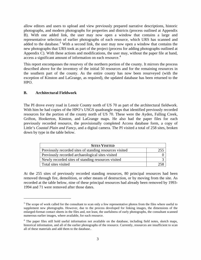
allow editors and users to upload and view previously prepared narrative descriptions, historic photographs, and modern photographs for properties and districts (process outlined at Appendix B). With one added link, the user may now open a window that contains a large and representative selection of earlier photographs of each resource, which URS has scanned and added to the database.3 With a second link, the user may now open a window that contains the new photographs that URS took as part of the project (process for adding photographs outlined at Appendix C). With these actions and modifications, the user may, without the paper file at hand, access a significant amount of information on each resource.4
This report encompasses the resurvey of the northern portion of the county. It mirrors the process described above for the inventory of the initial 50 resources and for the remaining resources in the southern part of the county. As the entire county has now been resurveyed (with the exception of Kinston and LaGrange, as required), the updated database has been returned to the HPO.
B. Architectural Fieldwork
The PI drove every road in Lenoir County north of US 70 as part of the architectural fieldwork. With him he had copies of the HPO’s USGS quadrangle maps that identified previously recorded resources for the portion of the county north of US 70. These were the Ayden, Falling Creek, Grifton, Hookerton, Kinston, and LaGrange maps. He also had the paper files for each previously recorded resource, the provisionally completed Access database form, a copy of Little’s Coastal Plain and Fancy, and a digital camera. The PI visited a total of 258 sites, broken down by type in the table below.
SITES VISITED Previously recorded sites of standing resources visited 255Previously recorded archaeological sites visited 0Newly recorded sites of standing resources visited 3Total sites visited 258
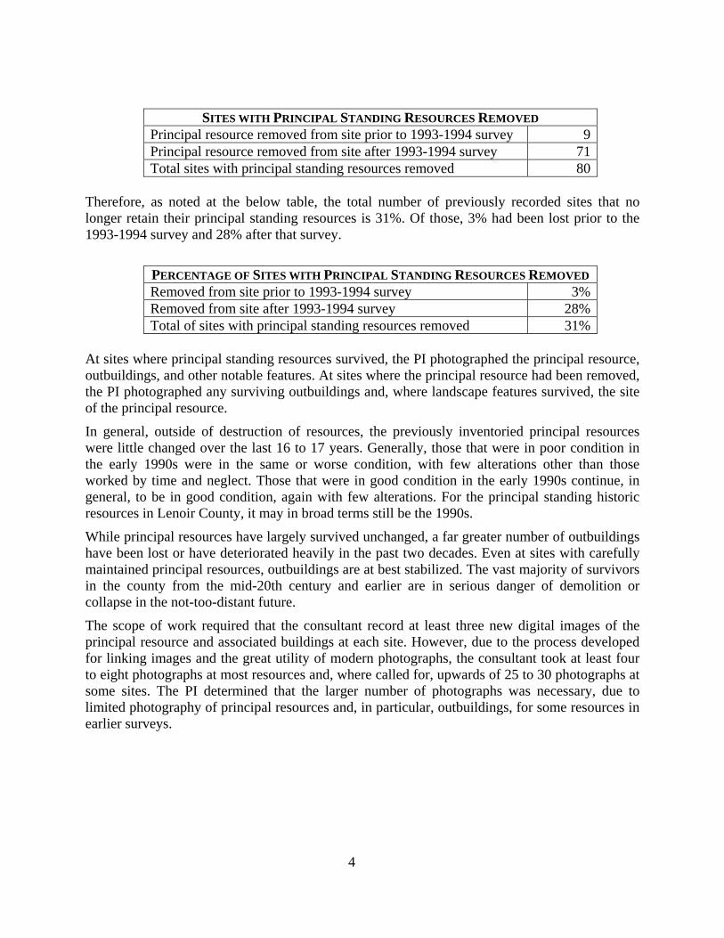
At the 255 sites of previously recorded standing resources, 80 principal resources had been removed through fire, demolition, or other means of destruction, or by moving from the site. As recorded at the table below, nine of these principal resources had already been removed by 1993-1994 and 71 were removed after those dates.
3 The scope of work called for the consultant to scan only a few representative photos from the files where useful to supplement new photographs. However, due to the process developed for linking images, the dimensions of the enlarged-format contact sheets in the files and, not least, the usefulness of early photographs, the consultant scanned numerous earlier images, where available, for each resource. 4 The paper files still hold useful information not available on the database, including field notes, sketch maps, historical information, and all of the earlier photographs of the resource. Currently, resources are insufficient to scan all of these materials and add them to the database..
4
SITES WITH PRINCIPAL STANDING RESOURCES REMOVED Principal resource removed from site prior to 1993-1994 survey 9Principal resource removed from site after 1993-1994 survey 71Total sites with principal standing resources removed 80
Therefore, as noted at the below table, the total number of previously recorded sites that no longer retain their principal standing resources is 31%. Of those, 3% had been lost prior to the 1993-1994 survey and 28% after that survey.
PERCENTAGE OF SITES WITH PRINCIPAL STANDING RESOURCES REMOVED Removed from site prior to 1993-1994 survey 3%Removed from site after 1993-1994 survey 28%Total of sites with principal standing resources removed 31%
At sites where principal standing resources survived, the PI photographed the principal resource, outbuildings, and other notable features. At sites where the principal resource had been removed, the PI photographed any surviving outbuildings and, where landscape features survived, the site of the principal resource.
In general, outside of destruction of resources, the previously inventoried principal resources were little changed over the last 16 to 17 years. Generally, those that were in poor condition in the early 1990s were in the same or worse condition, with few alterations other than those worked by time and neglect. Those that were in good condition in the early 1990s continue, in general, to be in good condition, again with few alterations. For the principal standing historic resources in Lenoir County, it may in broad terms still be the 1990s.
While principal resources have largely survived unchanged, a far greater number of outbuildings have been lost or have deteriorated heavily in the past two decades. Even at sites with carefully maintained principal resources, outbuildings are at best stabilized. The vast majority of survivors in the county from the mid-20th century and earlier are in serious danger of demolition or collapse in the not-too-distant future.
The scope of work required that the consultant record at least three new digital images of the principal resource and associated buildings at each site. However, due to the process developed for linking images and the great utility of modern photographs, the consultant took at least four to eight photographs at most resources and, where called for, upwards of 25 to 30 photographs at some sites. The PI determined that the larger number of photographs was necessary, due to limited photography of principal resources and, in particular, outbuildings, for some resources in earlier surveys.
5
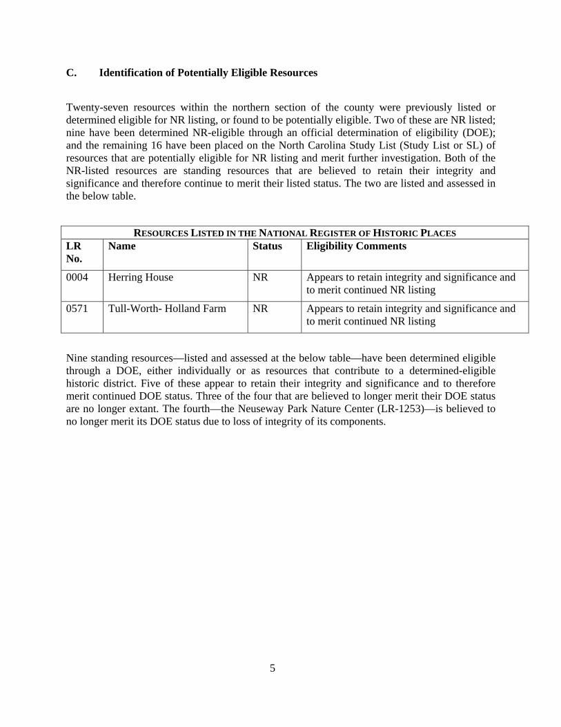
C. Identification of Potentially Eligible Resources
Twenty-seven resources within the northern section of the county were previously listed or determined eligible for NR listing, or found to be potentially eligible. Two of these are NR listed; nine have been determined NR-eligible through an official determination of eligibility (DOE); and the remaining 16 have been placed on the North Carolina Study List (Study List or SL) of resources that are potentially eligible for NR listing and merit further investigation. Both of the NR-listed resources are standing resources that are believed to retain their integrity and significance and therefore continue to merit their listed status. The two are listed and assessed in the below table.
RESOURCES LISTED IN THE NATIONAL REGISTER OF HISTORIC PLACES LR No.
Name Status Eligibility Comments
0004 Herring House NR Appears to retain integrity and significance and to merit continued NR listing
0571 Tull-Worth- Holland Farm NR Appears to retain integrity and significance and to merit continued NR listing
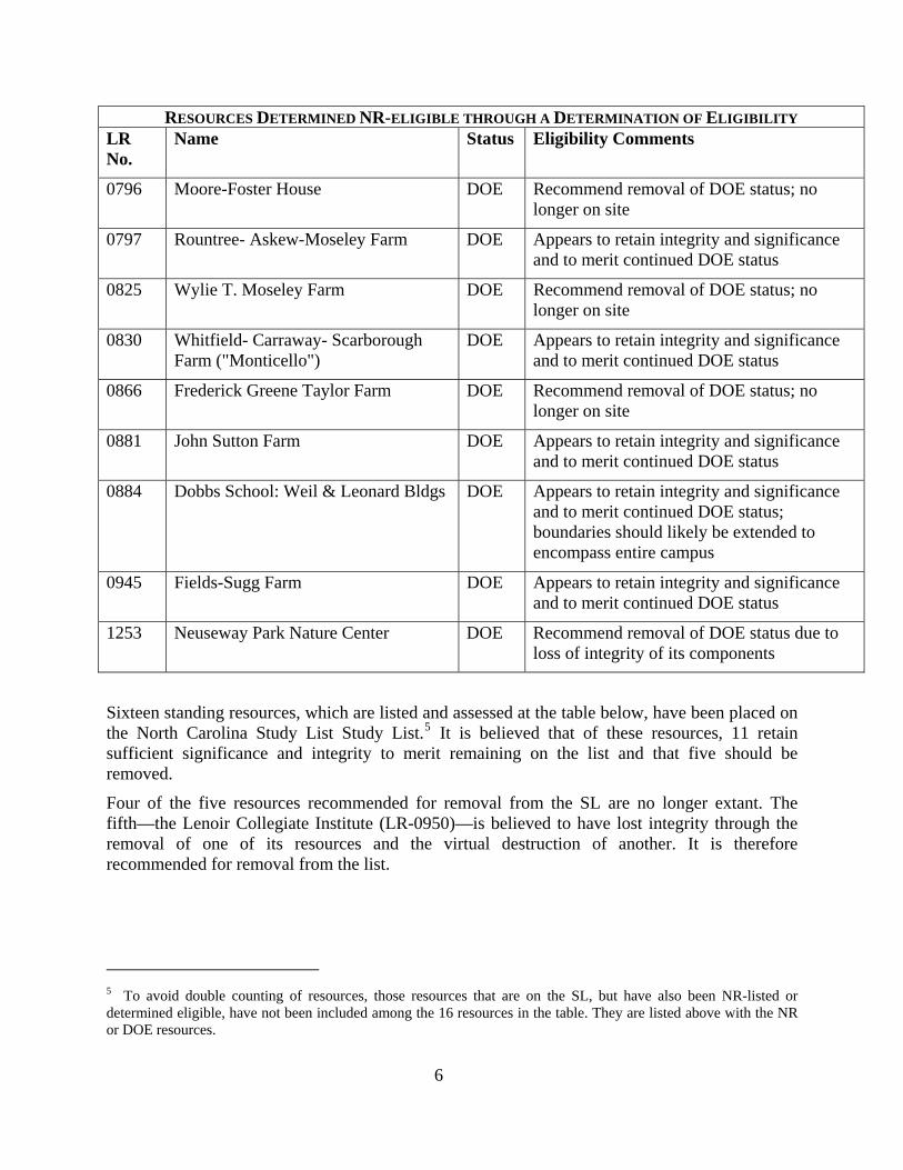
Nine standing resources—listed and assessed at the below table—have been determined eligible through a DOE, either individually or as resources that contribute to a determined-eligible historic district. Five of these appear to retain their integrity and significance and to therefore merit continued DOE status. Three of the four that are believed to longer merit their DOE status are no longer extant. The fourth—the Neuseway Park Nature Center (LR-1253)—is believed to no longer merit its DOE status due to loss of integrity of its components.
6
RESOURCES DETERMINED NR-ELIGIBLE THROUGH A DETERMINATION OF ELIGIBILITY LR No.
Name Status Eligibility Comments
0796 Moore-Foster House DOE Recommend removal of DOE status; no longer on site
0797 Rountree- Askew-Moseley Farm DOE Appears to retain integrity and significance and to merit continued DOE status
0825 Wylie T. Moseley Farm DOE Recommend removal of DOE status; no longer on site
0830 Whitfield- Carraway- Scarborough Farm ("Monticello")
DOE Appears to retain integrity and significance and to merit continued DOE status
0866 Frederick Greene Taylor Farm DOE Recommend removal of DOE status; no longer on site
0881 John Sutton Farm DOE Appears to retain integrity and significance and to merit continued DOE status
0884 Dobbs School: Weil & Leonard Bldgs DOE Appears to retain integrity and significance and to merit continued DOE status; boundaries should likely be extended to encompass entire campus
0945 Fields-Sugg Farm DOE Appears to retain integrity and significance and to merit continued DOE status
1253 Neuseway Park Nature Center DOE Recommend removal of DOE status due to loss of integrity of its components
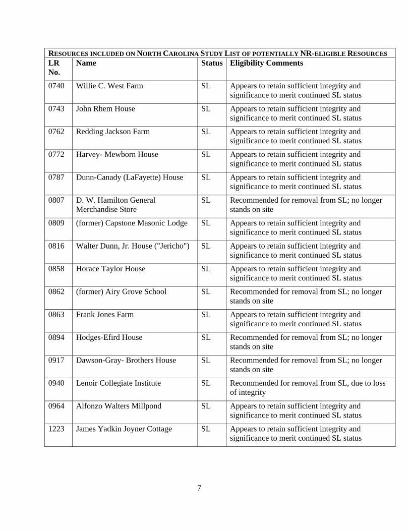
Sixteen standing resources, which are listed and assessed at the table below, have been placed on the North Carolina Study List Study List.5 It is believed that of these resources, 11 retain sufficient significance and integrity to merit remaining on the list and that five should be removed.
Four of the five resources recommended for removal from the SL are no longer extant. The fifth—the Lenoir Collegiate Institute (LR-0950)—is believed to have lost integrity through the removal of one of its resources and the virtual destruction of another. It is therefore recommended for removal from the list.
5 To avoid double counting of resources, those resources that are on the SL, but have also been NR-listed or determined eligible, have not been included among the 16 resources in the table. They are listed above with the NR or DOE resources.
7
RESOURCES INCLUDED ON NORTH CAROLINA STUDY LIST OF POTENTIALLY NR-ELIGIBLE RESOURCES LR No.
Name Status Eligibility Comments
0740 Willie C. West Farm SL Appears to retain sufficient integrity and significance to merit continued SL status
0743 John Rhem House SL Appears to retain sufficient integrity and significance to merit continued SL status
0762 Redding Jackson Farm SL Appears to retain sufficient integrity and significance to merit continued SL status
0772 Harvey- Mewborn House SL Appears to retain sufficient integrity and significance to merit continued SL status
0787 Dunn-Canady (LaFayette) House SL Appears to retain sufficient integrity and significance to merit continued SL status
0807 D. W. Hamilton General Merchandise Store
SL Recommended for removal from SL; no longer stands on site
0809 (former) Capstone Masonic Lodge SL Appears to retain sufficient integrity and significance to merit continued SL status
0816 Walter Dunn, Jr. House ("Jericho") SL Appears to retain sufficient integrity and significance to merit continued SL status
0858 Horace Taylor House SL Appears to retain sufficient integrity and significance to merit continued SL status
0862 (former) Airy Grove School SL Recommended for removal from SL; no longer stands on site
0863 Frank Jones Farm SL Appears to retain sufficient integrity and significance to merit continued SL status
0894 Hodges-Efird House SL Recommended for removal from SL; no longer stands on site
0917 Dawson-Gray- Brothers House SL Recommended for removal from SL; no longer stands on site
0940 Lenoir Collegiate Institute SL Recommended for removal from SL, due to loss of integrity
0964 Alfonzo Walters Millpond SL Appears to retain sufficient integrity and significance to merit continued SL status
1223 James Yadkin Joyner Cottage SL Appears to retain sufficient integrity and significance to merit continued SL status
8
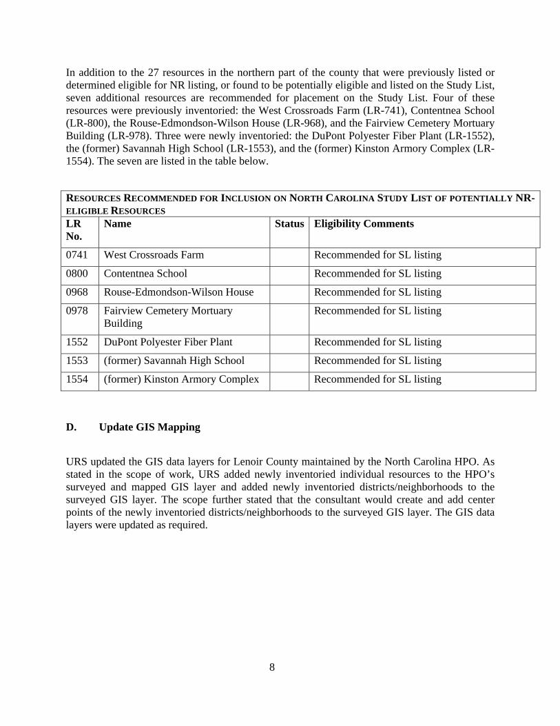
In addition to the 27 resources in the northern part of the county that were previously listed or determined eligible for NR listing, or found to be potentially eligible and listed on the Study List, seven additional resources are recommended for placement on the Study List. Four of these resources were previously inventoried: the West Crossroads Farm (LR-741), Contentnea School (LR-800), the Rouse-Edmondson-Wilson House (LR-968), and the Fairview Cemetery Mortuary Building (LR-978). Three were newly inventoried: the DuPont Polyester Fiber Plant (LR-1552), the (former) Savannah High School (LR-1553), and the (former) Kinston Armory Complex (LR-1554). The seven are listed in the table below.
RESOURCES RECOMMENDED FOR INCLUSION ON NORTH CAROLINA STUDY LIST OF POTENTIALLY NR-ELIGIBLE RESOURCES LR No.
Name Status Eligibility Comments
0741 West Crossroads Farm Recommended for SL listing
0800 Contentnea School Recommended for SL listing
0968 Rouse-Edmondson-Wilson House Recommended for SL listing
0978 Fairview Cemetery Mortuary Building
Recommended for SL listing
1552 DuPont Polyester Fiber Plant Recommended for SL listing
1553 (former) Savannah High School Recommended for SL listing
1554 (former) Kinston Armory Complex Recommended for SL listing
D. Update GIS Mapping
URS updated the GIS data layers for Lenoir County maintained by the North Carolina HPO. As stated in the scope of work, URS added newly inventoried individual resources to the HPO’s surveyed and mapped GIS layer and added newly inventoried districts/neighborhoods to the surveyed GIS layer. The scope further stated that the consultant would create and add center points of the newly inventoried districts/neighborhoods to the surveyed GIS layer. The GIS data layers were updated as required.
9
III. RECOMMENDATIONS AND CONCLUSIONS
A. Standing Resources
A total of 258 resources were visited during the updating of the inventory of the northern portion of Lenoir County, three of which were newly surveyed. Of these, the two resources that are listed on the NR appear to continue to retain their significance and integrity. Five of the nine resources that have been determined eligible for NR listing are also believed to continue to merit their DOEs. And 11 of the 16 resources included on the North Carolina SL are believed to still merit their positions on the list.
The original 1993-1994 survey was extremely effective in identifying the county’s most significant and intact standing historic resources. Nonetheless, four previously inventoried resources are recommended for inclusion on the Study List of potentially eligible resources. The three newly inventoried resources are recommended for inclusion on the SL as well. These three were not previously inventoried because they were less than 50 years of age when the county was surveyed back in the early 90s.
The large majority of previously inventoried principal standing resources in the northern portion of the county have changed little since 1993-1994. There are two exceptions to this rule. About 31 percent of principal resources have been lost since that time and numerous outbuildings have been lost or have heavily deteriorated over the same period of time. (By contrast, in the southern portion of the county, only 20 percent of previously inventoried resources have been lost. It too, though, has seen the destruction of many outbuildings.)
Due to technological advances since the early 1990s—including the development/improvement of county GIS databases, Access databases, scanning capabilities, and digital photography—many once difficult or time-consuming attributes of a resurvey of a well-studied county can now be relatively easily addressed. The mapping of resources and identification of tax parcel numbers is much easier, at least in counties such as Lenoir that have GIS databases. The HPO’s Access database is more user-friendly (at the front and the back end) than its predecessor. Earlier photographs can be scanned in and attached to survey forms in the database, as can modern digital photographs. Resurvey, therefore, makes access to the most important information contained in the HPO’s historic standing resources files far easier, particularly from locations outside of Raleigh and the western HPO office in Biltmore Forest.
Lenoir County is believed to provide a model for any future re-inventory of the large number of North Carolina’s counties that were previously comprehensively inventoried. For these counties, an entire resurvey may not be called for. Rather, a resurvey of those resources that are listed in the NR, have been determined eligible through a DOE, or have been placed on the SL may identify all or almost all of the eligible and potentially eligible resources in the most cost-effective way. This can be supplemented by additional resurvey, as needed, to more fully identify the historic resources in a county or to fully comply with such federal regulations as 36 CFR 800 (Section 106) and the National Environmental Policy Act (NEPA). As the eligibility of resources changes over time, no survey or resurvey, unless constantly updated, can conclusively
10
identify all notable or NR-eligible resources. Therefore, a limited amount of resurvey will always be necessary. The depth of this resurvey, however, should vary depending on what work has been previously done in the county and what the resurvey is intended to accomplish.
The resurvey of Lenoir County provides information that will be useful in determining what resources merit further study as part of a county or municipal inventory or a Section 106 or NEPA-driven project. The previous survey activity in Lenoir County, particularly that of 1993-1994, did not result in the inventory (or even the identification via abbreviated coded entries on the USGS field maps) of every resource in the county that was 50 years old or older at the time of the survey. It is believed that no countywide survey, and no or virtually no municipal survey, results in the inventory of every such resource. Nonetheless, the inventory identified almost all of the 50-year-old-or-older resources that were eligible for NR listing or for placement on the Study list. Therefore Section 106 and NEPA projects, like county and municipal inventory projects, may be successful even if they do not include survey of every resource that is 50 years old or older.
B. HPO Access Database
During this resurvey, a number of additions were made to the HPO’s Access database that, though somewhat time consuming, add to the utility of the Lenoir County database. Three notable changes were made by the consultant, in consultation with the HPO, that make the database more inclusive and useful. As described in detail at Appendix A, in addition to updating the information in the database to reflect the current conditions of historic properties in Lenoir County, the structure of the database was modified. These modifications allow editors and users to upload and view narrative descriptions, historic photographs, and modern photographs for properties and districts. While different and perhaps better means may be developed to make these changes—the process developed for adding labeled modern photographs to the database is somewhat unwieldy—it is believed that the Lenoir County database has been improved as a result of this project. It is recommended that similar changes be contemplated for the database as a whole.
11
IV. APPENDICES
APPENDIX A Annotated Inventory List for Resources
North of US 70 in Lenoir County, December 2010
APPENDIX B Modifications made to the Lenoir County MS Access Database
How to Use the NC HPO Survey Database for Lenoir County with Added Text and Photo Viewing Functionality
Database Modifications
APPENDIX C Inserting Text from Historic Files
Creating Modern and Historic Picture Files
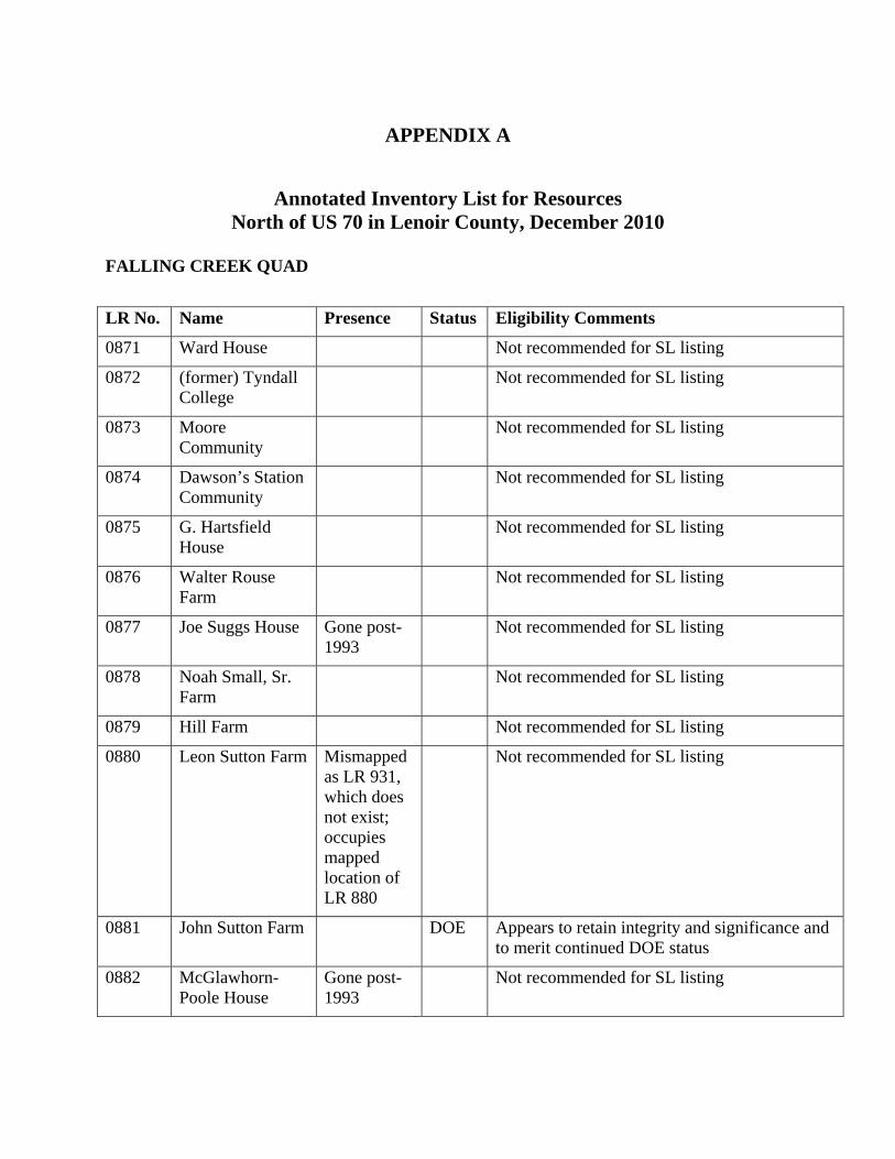
APPENDIX A
Annotated Inventory List for Resources North of US 70 in Lenoir County, December 2010
FALLING CREEK QUAD
LR No. Name Presence Status Eligibility Comments
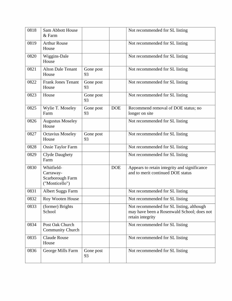
0871 Ward House Not recommended for SL listing
0872 (former) Tyndall College
Not recommended for SL listing
0873 Moore Community
Not recommended for SL listing
0874 Dawson’s Station Community
Not recommended for SL listing
0875 G. Hartsfield House
Not recommended for SL listing
0876 Walter Rouse Farm
Not recommended for SL listing
0877 Joe Suggs House Gone post-1993
Not recommended for SL listing
0878 Noah Small, Sr. Farm
Not recommended for SL listing
0879 Hill Farm Not recommended for SL listing
0880 Leon Sutton Farm Mismapped as LR 931, which does not exist; occupies mapped location of LR 880
Not recommended for SL listing
0881 John Sutton Farm DOE Appears to retain integrity and significance and to merit continued DOE status
0882 McGlawhorn- Poole House
Gone post-1993
Not recommended for SL listing
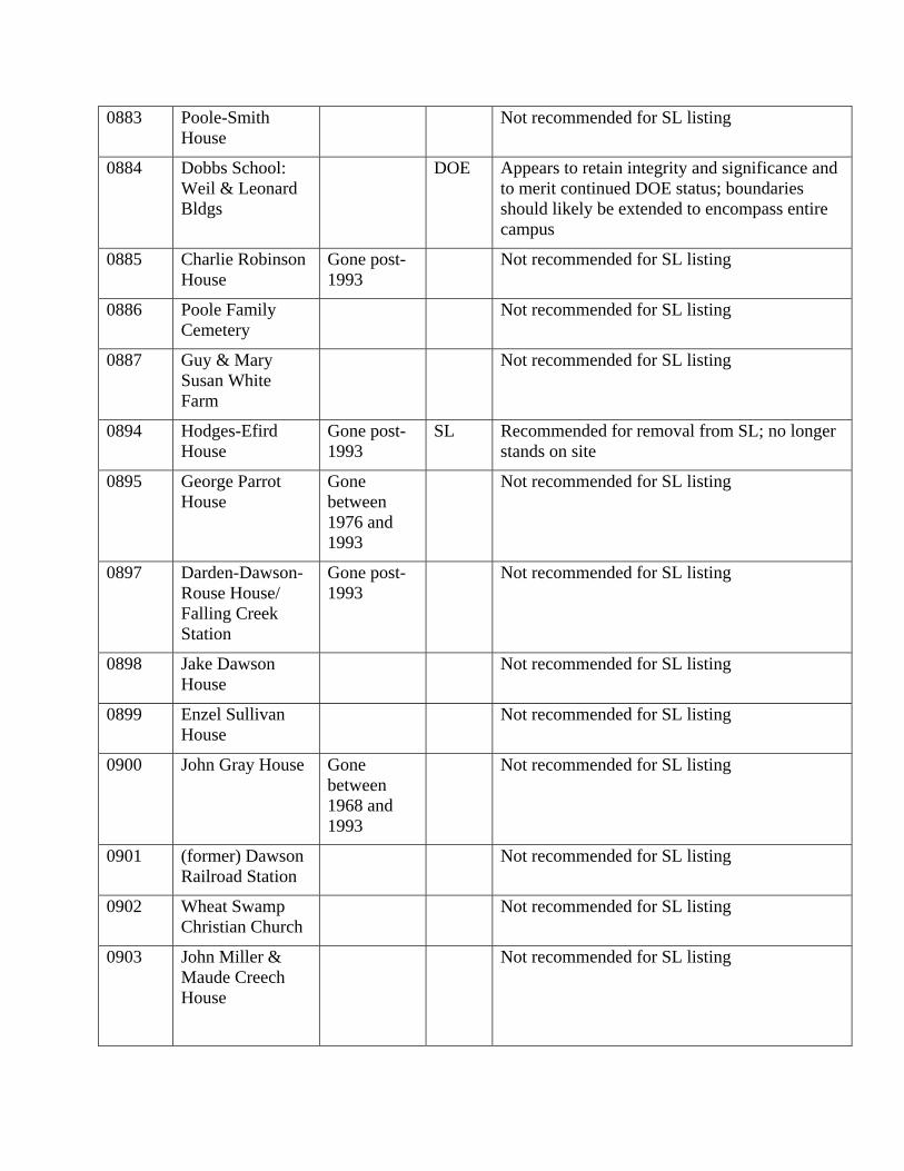
0883 Poole-Smith House
Not recommended for SL listing
0884 Dobbs School: Weil & Leonard Bldgs
DOE Appears to retain integrity and significance and to merit continued DOE status; boundaries should likely be extended to encompass entire campus
0885 Charlie Robinson House
Gone post-1993
Not recommended for SL listing
0886 Poole Family Cemetery
Not recommended for SL listing
0887 Guy & Mary Susan White Farm
Not recommended for SL listing
0894 Hodges-Efird House
Gone post-1993
SL Recommended for removal from SL; no longer stands on site
0895 George Parrot House
Gone between 1976 and 1993
Not recommended for SL listing
0897 Darden-Dawson-Rouse House/ Falling Creek Station
Gone post-1993
Not recommended for SL listing
0898 Jake Dawson House
Not recommended for SL listing
0899 Enzel Sullivan House
Not recommended for SL listing
0900 John Gray House Gone between 1968 and 1993
Not recommended for SL listing
0901 (former) Dawson Railroad Station
Not recommended for SL listing
0902 Wheat Swamp Christian Church
Not recommended for SL listing
0903 John Miller & Maude Creech House
Not recommended for SL listing
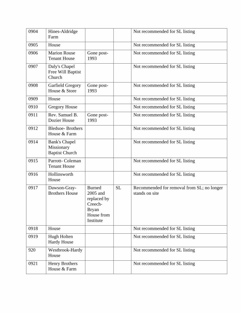
0904 Hines-Aldridge Farm
Not recommended for SL listing
0905 House Not recommended for SL listing
0906 Marion Rouse Tenant House
Gone post-1993
Not recommended for SL listing
0907 Daly's Chapel Free Will Baptist Church
Not recommended for SL listing
0908 Garfield Gregory House & Store
Gone post-1993
Not recommended for SL listing
0909 House Not recommended for SL listing
0910 Gregory House Not recommended for SL listing
0911 Rev. Samuel B. Dozier House
Gone post-1993
Not recommended for SL listing
0912 Bledsoe- Brothers House & Farm
Not recommended for SL listing
0914 Bank's Chapel Missionary Baptist Church
Not recommended for SL listing
0915 Parrott- Coleman Tenant House
Not recommended for SL listing
0916 Hollinsworth House
Not recommended for SL listing
0917 Dawson-Gray- Brothers House
Burned 2005 and replaced by Creech-Bryan House from Institute
SL Recommended for removal from SL; no longer stands on site
0918 House Not recommended for SL listing
0919 Hugh Holten Hardy House
Not recommended for SL listing
920 Westbrook-Hardy House
Not recommended for SL listing
0921 Henry Brothers House & Farm
Not recommended for SL listing
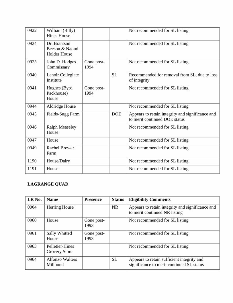
0922 William (Billy) Hines House
Not recommended for SL listing
0924 Dr. Brantson Beeson & Naomi Holder House
Not recommended for SL listing
0925 John D. Hodges Commissary
Gone post-1994
Not recommended for SL listing
0940 Lenoir Collegiate Institute
SL Recommended for removal from SL, due to loss of integrity
0941 Hughes (Byrd Packhouse) House
Gone post-1994
Not recommended for SL listing
0944 Aldridge House Not recommended for SL listing
0945 Fields-Sugg Farm DOE Appears to retain integrity and significance and to merit continued DOE status
0946 Ralph Measeley House
Not recommended for SL listing
0947 House Not recommended for SL listing
0949 Rachel Brewer Farm
Not recommended for SL listing
1190 House/Dairy Not recommended for SL listing
1191 House Not recommended for SL listing
LAGRANGE QUAD
LR No. Name Presence Status Eligibility Comments
0004 Herring House NR Appears to retain integrity and significance and to merit continued NR listing
0960 House Gone post-1993
Not recommended for SL listing
0961 Sally Whitted House
Gone post-1993
Not recommended for SL listing
0963 Pelletier-Hines Grocery Store
Not recommended for SL listing
0964 Alfonzo Walters Millpond
SL Appears to retain sufficient integrity and significance to merit continued SL status
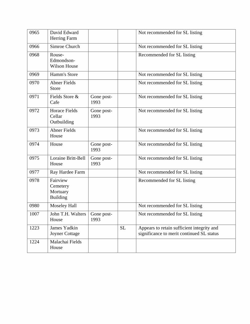
0965 David Edward Herring Farm
Not recommended for SL listing
0966 Simroe Church Not recommended for SL listing
0968 Rouse- Edmondson- Wilson House
Recommended for SL listing
0969 Hamm's Store Not recommended for SL listing
0970 Abner Fields Store
Not recommended for SL listing
0971 Fields Store & Cafe
Gone post-1993
Not recommended for SL listing
0972 Horace Fields Cellar Outbuilding
Gone post-1993
Not recommended for SL listing
0973 Abner Fields House
Not recommended for SL listing
0974 House Gone post-1993
Not recommended for SL listing
0975 Loraine Britt-Bell House
Gone post-1993
Not recommended for SL listing
0977 Ray Hardee Farm Not recommended for SL listing
0978 Fairview Cemetery Mortuary Building
Recommended for SL listing
0980 Moseley Hall Not recommended for SL listing
1007 John T.H. Walters House
Gone post-1993
Not recommended for SL listing
1223 James Yadkin Joyner Cottage
SL Appears to retain sufficient integrity and significance to merit continued SL status
1224 Malachai Fields House
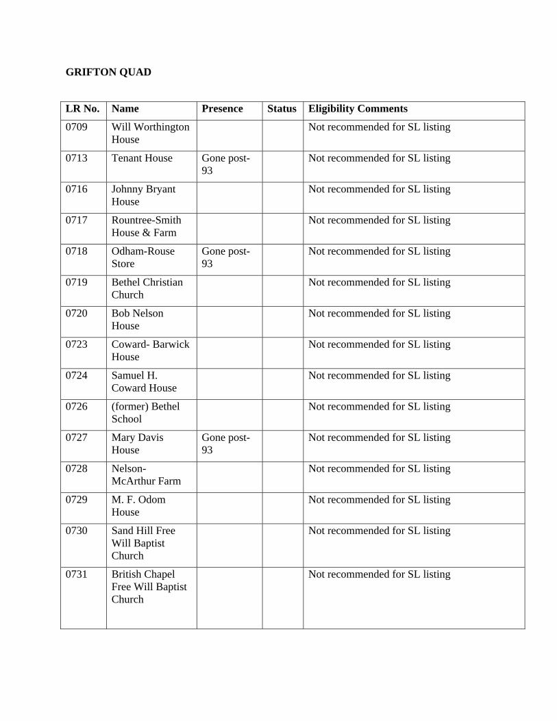
GRIFTON QUAD
LR No. Name Presence Status Eligibility Comments
0709 Will Worthington House
Not recommended for SL listing
0713 Tenant House Gone post-93
Not recommended for SL listing
0716 Johnny Bryant House
Not recommended for SL listing
0717 Rountree-Smith House & Farm
Not recommended for SL listing
0718 Odham-Rouse Store
Gone post-93
Not recommended for SL listing
0719 Bethel Christian Church
Not recommended for SL listing
0720 Bob Nelson House
Not recommended for SL listing
0723 Coward- Barwick House
Not recommended for SL listing
0724 Samuel H. Coward House
Not recommended for SL listing
0726 (former) Bethel School
Not recommended for SL listing
0727 Mary Davis House
Gone post-93
Not recommended for SL listing
0728 Nelson- McArthur Farm
Not recommended for SL listing
0729 M. F. Odom House
Not recommended for SL listing
0730 Sand Hill Free Will Baptist Church
Not recommended for SL listing
0731 British Chapel Free Will Baptist Church
Not recommended for SL listing
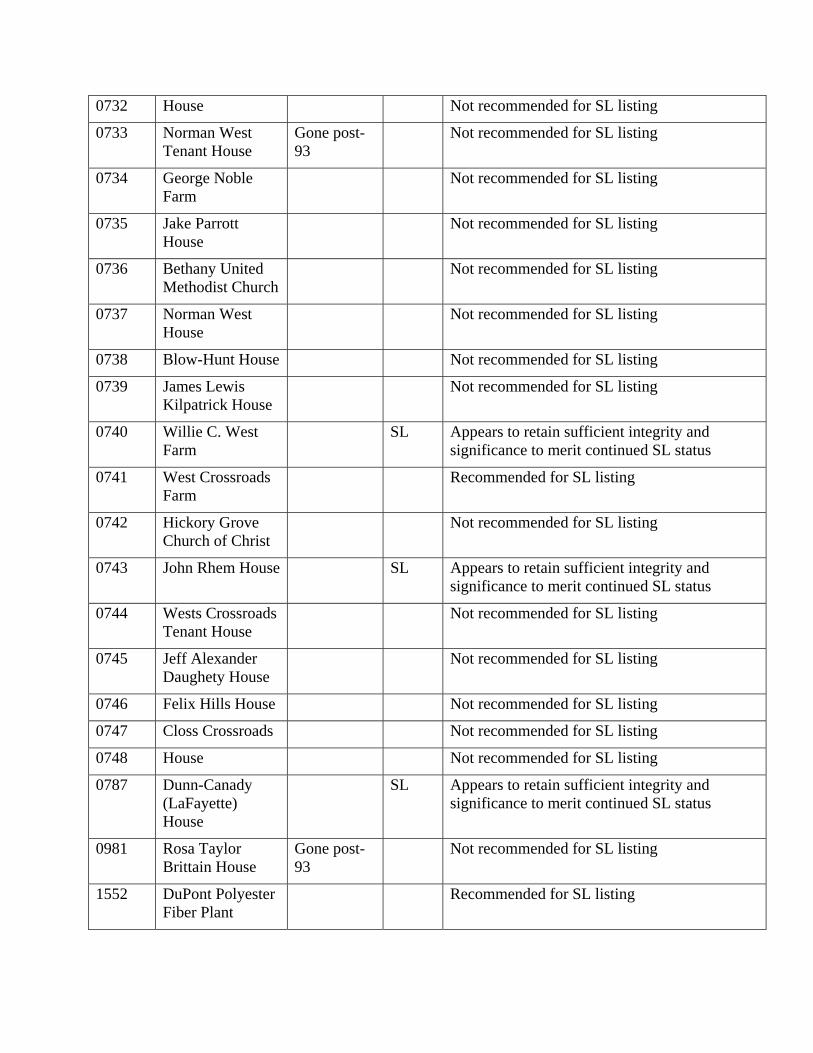
0732 House Not recommended for SL listing
0733 Norman West Tenant House
Gone post-93
Not recommended for SL listing
0734 George Noble Farm
Not recommended for SL listing
0735 Jake Parrott House
Not recommended for SL listing
0736 Bethany United Methodist Church
Not recommended for SL listing
0737 Norman West House
Not recommended for SL listing
0738 Blow-Hunt House Not recommended for SL listing
0739 James Lewis Kilpatrick House
Not recommended for SL listing
0740 Willie C. West Farm
SL Appears to retain sufficient integrity and significance to merit continued SL status
0741 West Crossroads Farm
Recommended for SL listing
0742 Hickory Grove Church of Christ
Not recommended for SL listing
0743 John Rhem House SL Appears to retain sufficient integrity and significance to merit continued SL status
0744 Wests Crossroads Tenant House
Not recommended for SL listing
0745 Jeff Alexander Daughety House
Not recommended for SL listing
0746 Felix Hills House Not recommended for SL listing
0747 Closs Crossroads Not recommended for SL listing
0748 House Not recommended for SL listing
0787 Dunn-Canady (LaFayette) House
SL Appears to retain sufficient integrity and significance to merit continued SL status
0981 Rosa Taylor Brittain House
Gone post-93
Not recommended for SL listing
1552 DuPont Polyester Fiber Plant
Recommended for SL listing
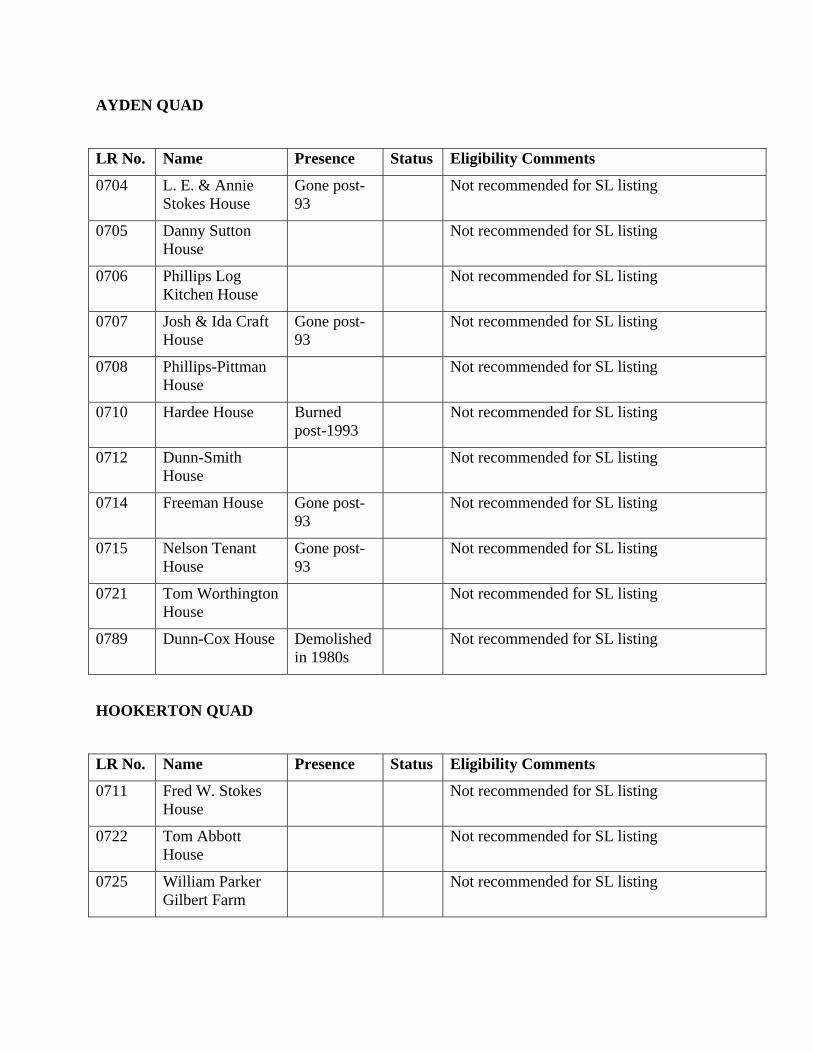
AYDEN QUAD
LR No. Name Presence Status Eligibility Comments
0704 L. E. & Annie Stokes House
Gone post-93
Not recommended for SL listing
0705 Danny Sutton House
Not recommended for SL listing
0706 Phillips Log Kitchen House
Not recommended for SL listing
0707 Josh & Ida Craft House
Gone post-93
Not recommended for SL listing
0708 Phillips-Pittman House
Not recommended for SL listing
0710 Hardee House Burned post-1993
Not recommended for SL listing
0712 Dunn-Smith House
Not recommended for SL listing
0714 Freeman House Gone post-93
Not recommended for SL listing
0715 Nelson Tenant House
Gone post-93
Not recommended for SL listing
0721 Tom Worthington House
Not recommended for SL listing
0789 Dunn-Cox House Demolished in 1980s
Not recommended for SL listing
HOOKERTON QUAD
LR No. Name Presence Status Eligibility Comments
0711 Fred W. Stokes House
Not recommended for SL listing
0722 Tom Abbott House
Not recommended for SL listing
0725 William Parker Gilbert Farm
Not recommended for SL listing
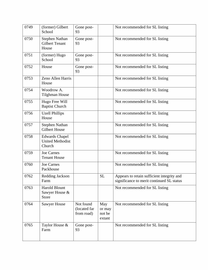
0749 (former) Gilbert School
Gone post-93
Not recommended for SL listing
0750 Stephen Nathan Gilbert Tenant House
Gone post-93
Not recommended for SL listing
0751 (former) Hugo School
Gone post-93
Not recommended for SL listing
0752 House Gone post-93
Not recommended for SL listing
0753 Zeno Allen Harris House
Not recommended for SL listing
0754 Woodrow A. Tilghman House
Not recommended for SL listing
0755 Hugo Free Will Baptist Church
Not recommended for SL listing
0756 Uzell Phillips House
Not recommended for SL listing
0757 Stephen Nathan Gilbert House
Not recommended for SL listing
0758 Edwards Chapel United Methodist Church
Not recommended for SL listing
0759 Joe Carnes Tenant House
Not recommended for SL listing
0760 Joe Carnes Packhouse
Not recommended for SL listing
0762 Redding Jackson Farm
SL Appears to retain sufficient integrity and significance to merit continued SL status
0763 Harold Blount Sawyer House & Store
Not recommended for SL listing
0764 Sawyer House Not found (located far from road)
May or may not be extant
Not recommended for SL listing
0765 Taylor House & Farm
Gone post-93
Not recommended for SL listing
0766 Kenneth Hall House
Not recommended for SL listing
0767 Buck Smith House
Not recommended for SL listing
0768 Elias Liverman Hazelton House
Gone post-93
Not recommended for SL listing
0824 Coward- Murphy Farm
Gone post-93
Not recommended for SL listing
0893 Gilbert Town Not recommended for SL listing
0913 Smith-Perry Farm Not recommended for SL listing
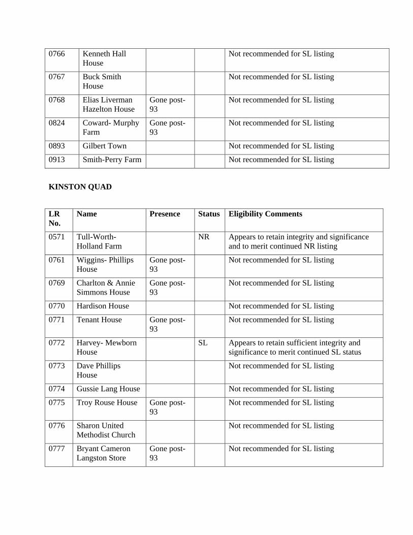
KINSTON QUAD
LR No.
Name Presence Status Eligibility Comments
0571 Tull-Worth- Holland Farm
NR Appears to retain integrity and significance and to merit continued NR listing
0761 Wiggins- Phillips House
Gone post-93
Not recommended for SL listing
0769 Charlton & Annie Simmons House
Gone post-93
Not recommended for SL listing
0770 Hardison House Not recommended for SL listing
0771 Tenant House Gone post-93
Not recommended for SL listing
0772 Harvey- Mewborn House
SL Appears to retain sufficient integrity and significance to merit continued SL status
0773 Dave Phillips House
Not recommended for SL listing
0774 Gussie Lang House Not recommended for SL listing
0775 Troy Rouse House Gone post-93
Not recommended for SL listing
0776 Sharon United Methodist Church
Not recommended for SL listing
0777 Bryant Cameron Langston Store
Gone post-93
Not recommended for SL listing
0778 Canady Tenant House
Gone post-93
Not recommended for SL listing
0779 Bryant Cameron Langston House
Not recommended for SL listing
0780 Sherman Odham House
Not recommended for SL listing
0781 Savannah Free Will Baptist Church
Not recommended for SL listing
0782 Jay R. Fields House Gone post-93
Not recommended for SL listing
0783 Taylor-Fields House
Gone post-93
Not recommended for SL listing
0784 Brown House Not recommended for SL listing
0785 Wiley Whitley House
Gone post-93
Not recommended for SL listing
0788 Harvey-Moore House (DESTROYED
Demo’ed between 1968 & 93
Not recommended for SL listing
0791 Moore-Heath House
Burned pre 1993; then demo’ed
Not recommended for SL listing
0792 (former) Heath School
Gone post-93
Not recommended for SL listing
0793 Airy Grove Christian Church
Not recommended for SL listing
0794 E. N. Dickerson Tenant Farm
Gone post-93
Not recommended for SL listing
0795 Willie Humphrey Farm
Not recommended for SL listing
0796 Moore-Foster House
Burned March 1996
DOE Recommend removal of DOE status; no longer on site
0797 Rountree- Askew-Moseley Farm
DOE Appears to retain integrity and significance and to merit continued DOE status
0798 Ernest L. Johnson Farm
Not recommended for SL listing
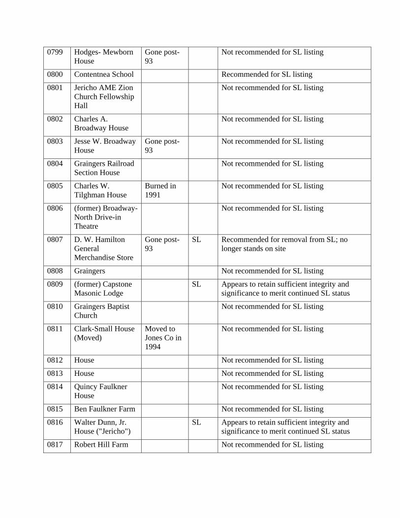
0799 Hodges- Mewborn House
Gone post-93
Not recommended for SL listing
0800 Contentnea School Recommended for SL listing
0801 Jericho AME Zion Church Fellowship Hall
Not recommended for SL listing
0802 Charles A. Broadway House
Not recommended for SL listing
0803 Jesse W. Broadway House
Gone post-93
Not recommended for SL listing
0804 Graingers Railroad Section House
Not recommended for SL listing
0805 Charles W. Tilghman House
Burned in 1991
Not recommended for SL listing
0806 (former) Broadway- North Drive-in Theatre
Not recommended for SL listing
0807 D. W. Hamilton General Merchandise Store
Gone post-93
SL Recommended for removal from SL; no longer stands on site
0808 Graingers Not recommended for SL listing
0809 (former) Capstone Masonic Lodge
SL Appears to retain sufficient integrity and significance to merit continued SL status
0810 Graingers Baptist Church
Not recommended for SL listing
0811 Clark-Small House (Moved)
Moved to Jones Co in 1994
Not recommended for SL listing
0812 House Not recommended for SL listing
0813 House Not recommended for SL listing
0814 Quincy Faulkner House
Not recommended for SL listing
0815 Ben Faulkner Farm Not recommended for SL listing
0816 Walter Dunn, Jr. House ("Jericho")
SL Appears to retain sufficient integrity and significance to merit continued SL status
0817 Robert Hill Farm Not recommended for SL listing
0818 Sam Abbott House & Farm
Not recommended for SL listing
0819 Arthur Rouse House
Not recommended for SL listing
0820 Wiggins-Dale House
Not recommended for SL listing
0821 Alton Dale Tenant House
Gone post 93
Not recommended for SL listing
0822 Frank Jones Tenant House
Gone post 93
Not recommended for SL listing
0823 House Gone post 93
Not recommended for SL listing
0825 Wylie T. Moseley Farm
Gone post 93
DOE Recommend removal of DOE status; no longer on site
0826 Augustus Moseley House
Not recommended for SL listing
0827 Octavius Moseley House
Gone post 93
Not recommended for SL listing
0828 Ossie Taylor Farm Not recommended for SL listing
0829 Clyde Daughety Farm
Not recommended for SL listing
0830 Whitfield- Carraway- Scarborough Farm ("Monticello")
DOE Appears to retain integrity and significance and to merit continued DOE status
0831 Albert Suggs Farm Not recommended for SL listing
0832 Roy Wooten House Not recommended for SL listing
0833 (former) Brights School
Not recommended for SL listing, although may have been a Rosenwald School; does not retain integrity
0834 Post Oak Church Community Church
Not recommended for SL listing
0835 Claude Rouse House
Not recommended for SL listing
0836 George Mills Farm
Gone post 93
Not recommended for SL listing
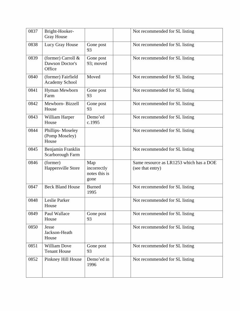
0837 Bright-Hooker- Gray House
Not recommended for SL listing
0838 Lucy Gray House Gone post 93
Not recommended for SL listing
0839 (former) Carroll & Dawson Doctor's Office
Gone post 93; moved
Not recommended for SL listing
0840 (former) Fairfield Academy School
Moved Not recommended for SL listing
0841 Hyman Mewborn Farm
Gone post 93
Not recommended for SL listing
0842 Mewborn- Bizzell House
Gone post 93
Not recommended for SL listing
0843 William Harper House
Demo’ed c.1995
Not recommended for SL listing
0844 Phillips- Moseley (Pomp Moseley) House
Not recommended for SL listing
0845 Benjamin Franklin Scarborough Farm
Not recommended for SL listing
0846 (former) Happersville Store
Map incorrectly notes this is gone
Same resource as LR1253 which has a DOE (see that entry)
0847 Beck Bland House Burned 1995
Not recommended for SL listing
0848 Leslie Parker House
Not recommended for SL listing
0849 Paul Wallace House
Gone post 93
Not recommended for SL listing
0850 Jesse Jackson-Heath House
Not recommended for SL listing
0851 William Dove Tenant House
Gone post 93
Not recommended for SL listing
0852 Pinkney Hill House Demo’ed in 1996
Not recommended for SL listing
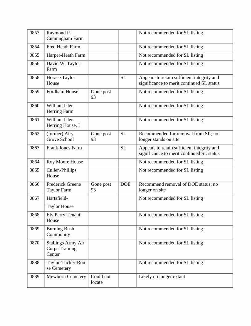
0853 Raymond P. Cunningham Farm
Not recommended for SL listing
0854 Fred Heath Farm Not recommended for SL listing
0855 Harper-Heath Farm Not recommended for SL listing
0856 David W. Taylor Farm
Not recommended for SL listing
0858 Horace Taylor House
SL Appears to retain sufficient integrity and significance to merit continued SL status
0859 Fordham House Gone post 93
Not recommended for SL listing
0860 William Isler Herring Farm
Not recommended for SL listing
0861 William Isler Herring House, I
Not recommended for SL listing
0862 (former) Airy Grove School
Gone post 93
SL Recommended for removal from SL; no longer stands on site
0863 Frank Jones Farm SL Appears to retain sufficient integrity and significance to merit continued SL status
0864 Roy Moore House Not recommended for SL listing
0865 Cullen-Phillips House
Not recommended for SL listing
0866 Frederick Greene Taylor Farm
Gone post 93
DOE Recommend removal of DOE status; no longer on site
0867 Hartsfield-
Taylor House
Not recommended for SL listing
0868 Ely Perry Tenant House
Not recommended for SL listing
0869 Burning Bush Community
Not recommended for SL listing
0870 Stallings Army Air Corps Training Center
Not recommended for SL listing
0888 Taylor-Tucker-Rouse Cemetery
Not recommended for SL listing
0889 Mewborn Cemetery Could not locate
Likely no longer extant
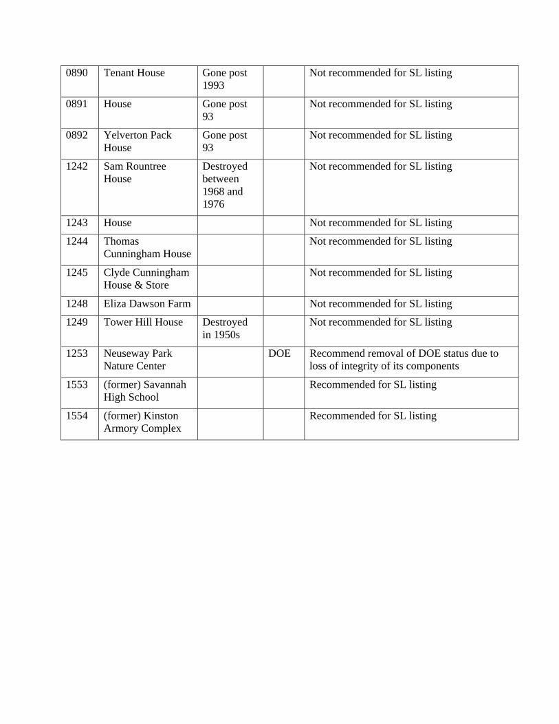
0890 Tenant House Gone post 1993
Not recommended for SL listing
0891 House Gone post 93
Not recommended for SL listing
0892 Yelverton Pack House
Gone post 93
Not recommended for SL listing
1242 Sam Rountree House
Destroyed between 1968 and 1976
Not recommended for SL listing
1243 House Not recommended for SL listing
1244 Thomas Cunningham House
Not recommended for SL listing
1245 Clyde Cunningham House & Store
Not recommended for SL listing
1248 Eliza Dawson Farm Not recommended for SL listing
1249 Tower Hill House Destroyed in 1950s
Not recommended for SL listing
1253 Neuseway Park Nature Center
DOE Recommend removal of DOE status due to loss of integrity of its components
1553 (former) Savannah High School
Recommended for SL listing
1554 (former) Kinston Armory Complex
Recommended for SL listing
APPENDIX B
Modifications made to the Lenoir County MS Access Database
As part of the Kinston Bypass Project and Archaeological Survey Update project, the Lenoir County NC HPO Survey Database was updated to reflect current conditions of historic properties in Lenoir County. In addition to updating this information, the structure of the database was modified. These modifications allow editors and users to upload and view narrative descriptions, historic photographs, and modern photographs for properties and districts.
Instructions for using the additional functionality of the database are provided in Appendix A. Also, a detailed list of exactly what was modified in the database structure is provided in Appendix B.
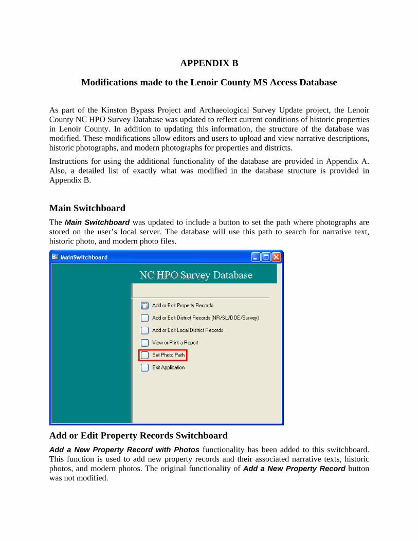
Main Switchboard The Main Switchboard was updated to include a button to set the path where photographs are stored on the user’s local server. The database will use this path to search for narrative text, historic photo, and modern photo files.
Add or Edit Property Records Switchboard Add a New Property Record with Photos functionality has been added to this switchboard. This function is used to add new property records and their associated narrative texts, historic photos, and modern photos. The original functionality of Add a New Property Record button was not modified.
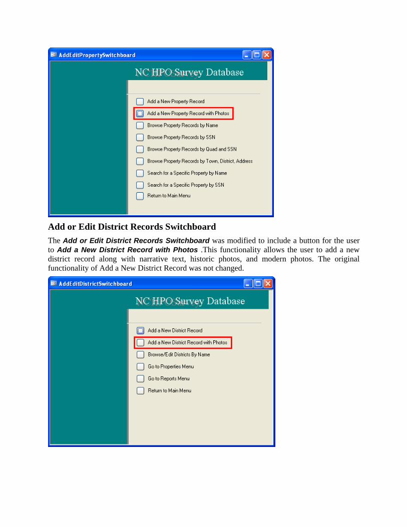
Add or Edit District Records Switchboard The Add or Edit District Records Switchboard was modified to include a button for the user to Add a New District Record with Photos .This functionality allows the user to add a new district record along with narrative text, historic photos, and modern photos. The original functionality of Add a New District Record was not changed.
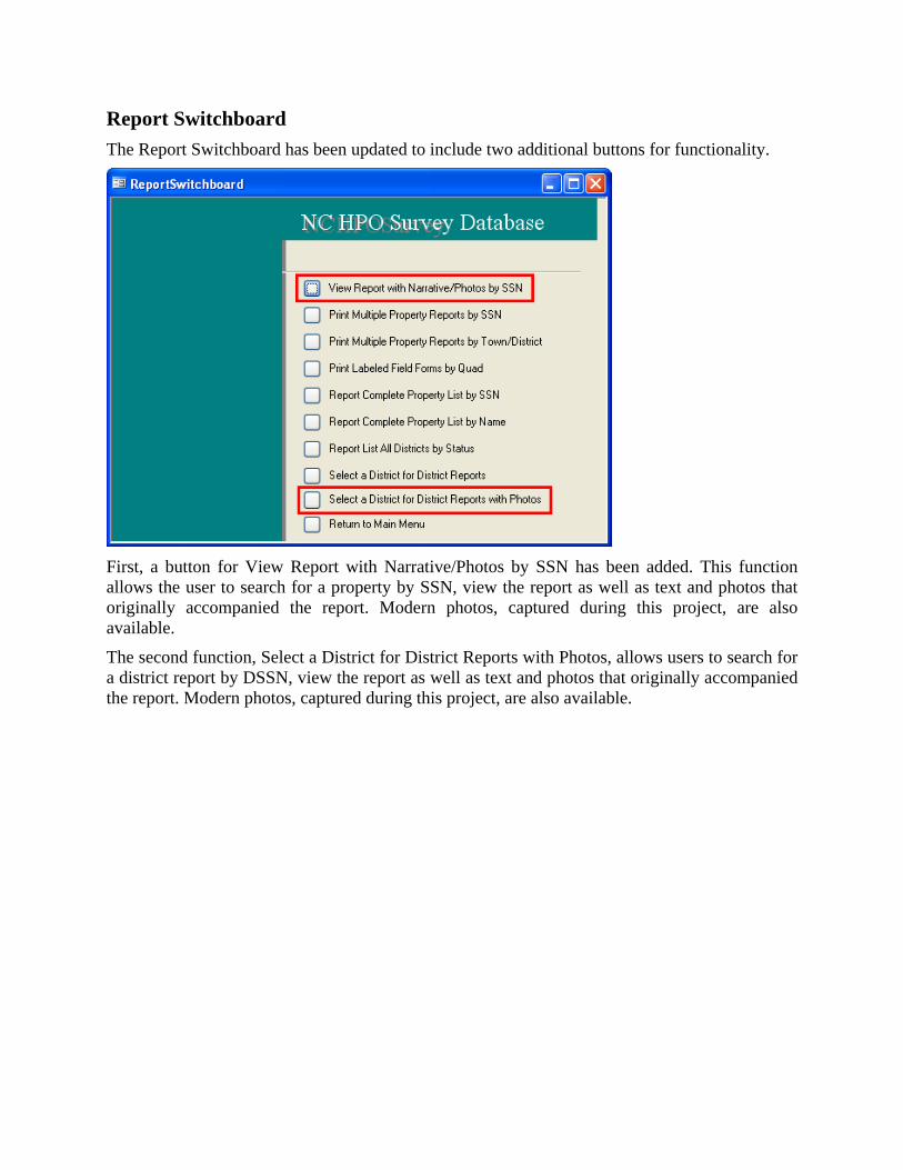
Report Switchboard The Report Switchboard has been updated to include two additional buttons for functionality.
First, a button for View Report with Narrative/Photos by SSN has been added. This function allows the user to search for a property by SSN, view the report as well as text and photos that originally accompanied the report. Modern photos, captured during this project, are also available.
The second function, Select a District for District Reports with Photos, allows users to search for a district report by DSSN, view the report as well as text and photos that originally accompanied the report. Modern photos, captured during this project, are also available.

How to Use the NC HPO Survey Database for Lenoir County with Added Text and Photo Viewing Functionality
1.0 Introduction
URS Corporation modified the Lenoir County portion of the NC HPO Survey Database to display images of narrative text and both historic and modern photographs. Existing property narratives and photographs were scanned into PDF files. The user can access these PDF files using this database.
Historic properties in Lenoir County were resurveyed in 2010 under the Kinston Bypass Project and Archaeological Survey Update projects. During this process, modern photographs were captured. These photographs have also been stored as PDF files and are accessible through the database.
Section 0 of this document describes the functionality of the linked photos included in the Lenoir County database. This section also outlines methods used to add new photos to existing property records and add new property records and associated photos. Section 0 provides instructions for adding linked photo capability to other databases. Appendix A outlines the specific changes that were made to tables, queries, forms, reports, and modules.
2.0 Linked Photo Database Capabilities
This section describes the file structure and system requirements necessary to utilize linked photos within the database. First, instructions on accessing photos which are already linked are provided. Instructions describing how to add photos to existing historic properties are provided next. Finally, instructions describing how to add photos to new historic properties are provided.
2.1 Database Requirements
The Lenoir county database has several requirements in order to work properly:
1. The file called MouseHook.dll must be in the same folder as the database.
2. The file called NIA.JPG must be in the same folder as the PDF files.
3. All PDF files (text, historic, and modern photos) must be placed in the same folder.
4. A PDF viewer program, such as Adobe Acrobat, must be installed on the computer.
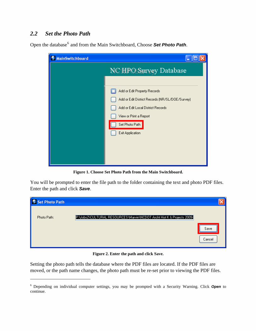
2.2 Set the Photo Path
Open the database6 and from the Main Switchboard, Choose Set Photo Path.
Figure 1. Choose Set Photo Path from the Main Switchboard.
You will be prompted to enter the file path to the folder containing the text and photo PDF files. Enter the path and click Save.
Figure 2. Enter the path and click Save.
Setting the photo path tells the database where the PDF files are located. If the PDF files are moved, or the path name changes, the photo path must be re-set prior to viewing the PDF files.
6 Depending on individual computer settings, you may be prompted with a Security Warning. Click Open to continue.
2.3 View Text and Photos by Property Report
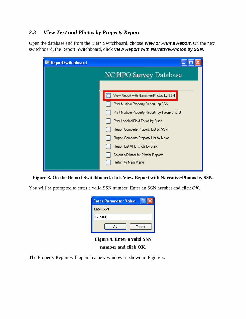
Open the database and from the Main Switchboard, choose View or Print a Report. On the next switchboard, the Report Switchboard, click View Report with Narrative/Photos by SSN.
Figure 3. On the Report Switchboard, click View Report with Narrative/Photos by SSN.
You will be prompted to enter a valid SSN number. Enter an SSN number and click OK.
Figure 4. Enter a valid SSN
number and click OK.
The Property Report will open in a new window as shown in Figure 5.
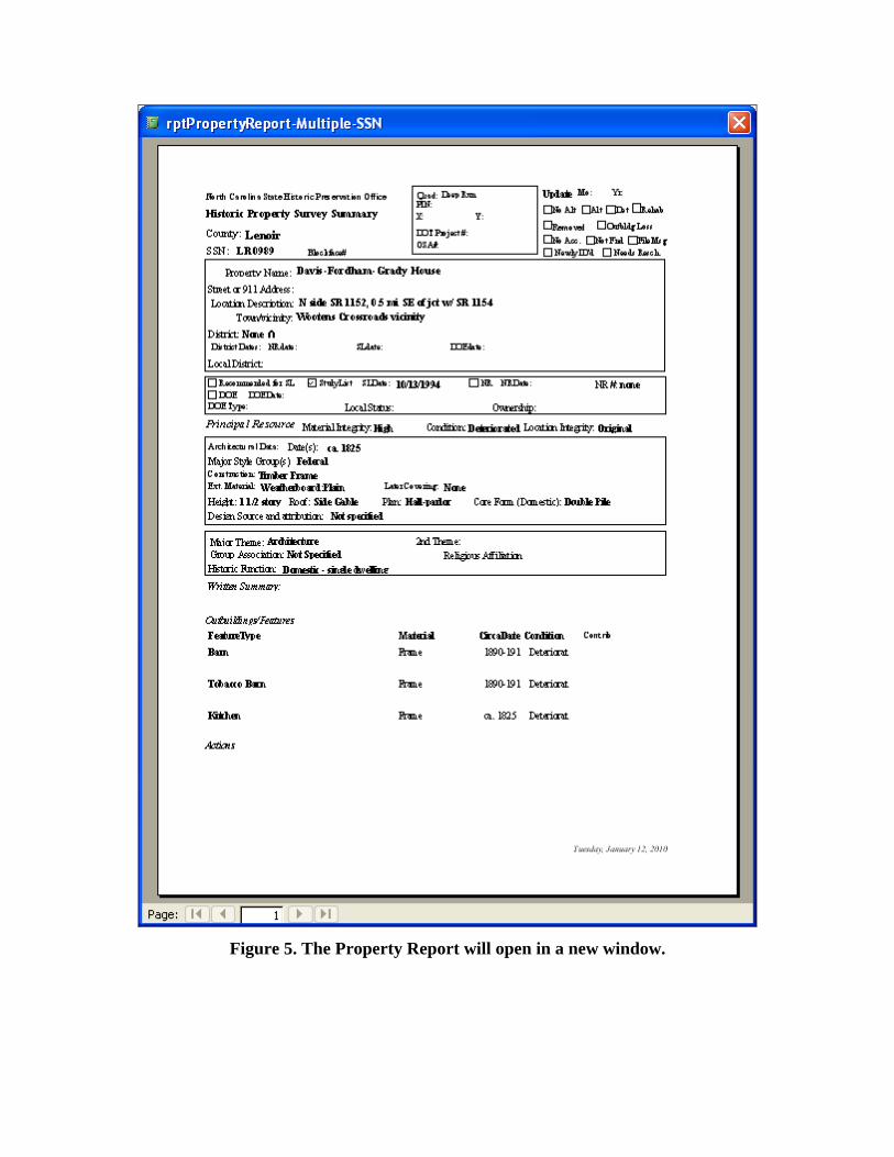
Figure 5. The Property Report will open in a new window.
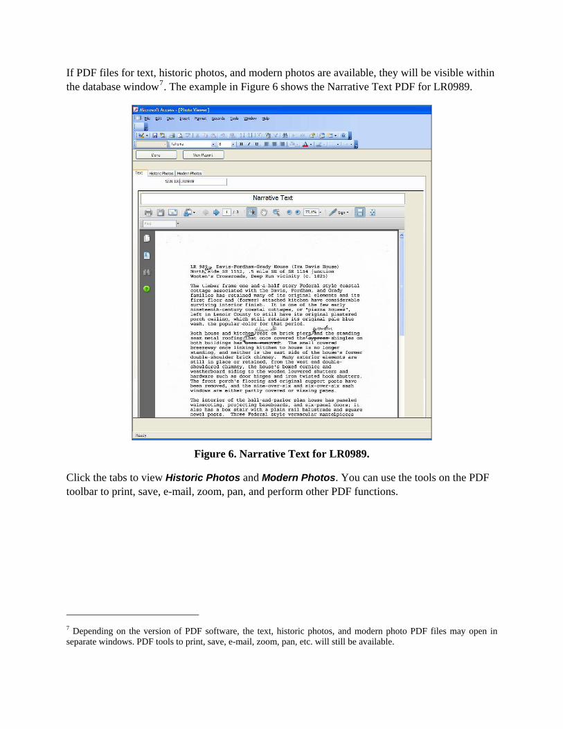
If PDF files for text, historic photos, and modern photos are available, they will be visible within the database window7. The example in Figure 6 shows the Narrative Text PDF for LR0989.
Figure 6. Narrative Text for LR0989.
Click the tabs to view Historic Photos and Modern Photos. You can use the tools on the PDF toolbar to print, save, e-mail, zoom, pan, and perform other PDF functions.
7 Depending on the version of PDF software, the text, historic photos, and modern photo PDF files may open in separate windows. PDF tools to print, save, e-mail, zoom, pan, etc. will still be available.
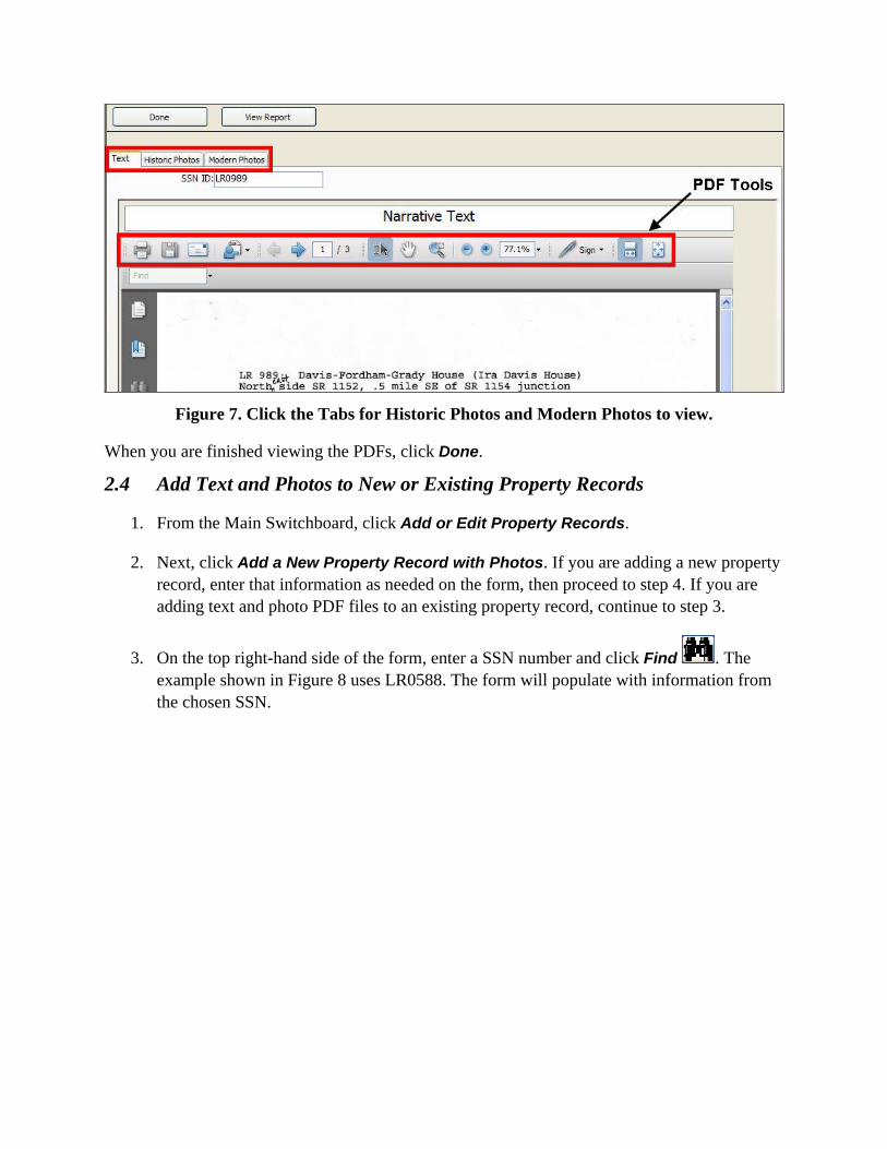
Figure 7. Click the Tabs for Historic Photos and Modern Photos to view.
When you are finished viewing the PDFs, click Done.
2.4 Add Text and Photos to New or Existing Property Records
1. From the Main Switchboard, click Add or Edit Property Records.
2. Next, click Add a New Property Record with Photos. If you are adding a new property record, enter that information as needed on the form, then proceed to step 4. If you are adding text and photo PDF files to an existing property record, continue to step 3.
3. On the top right-hand side of the form, enter a SSN number and click Find . The example shown in Figure 8 uses LR0588. The form will populate with information from the chosen SSN.
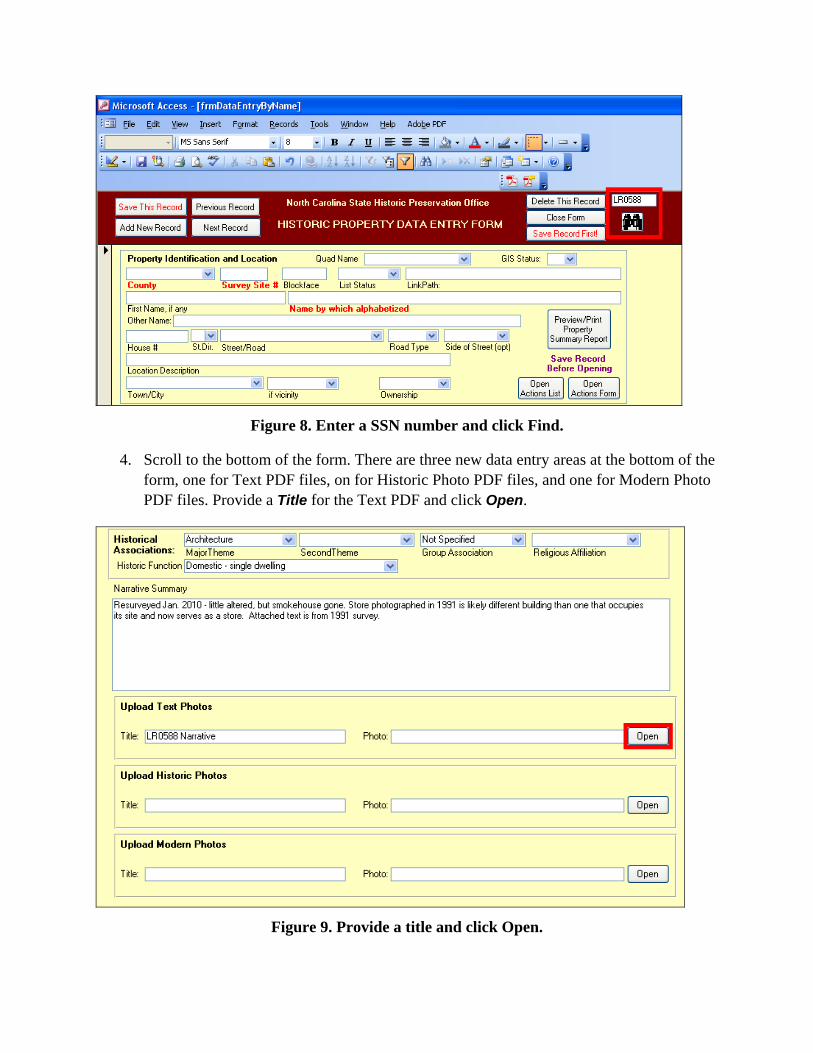
Figure 8. Enter a SSN number and click Find.
4. Scroll to the bottom of the form. There are three new data entry areas at the bottom of the form, one for Text PDF files, on for Historic Photo PDF files, and one for Modern Photo PDF files. Provide a Title for the Text PDF and click Open.
Figure 9. Provide a title and click Open.
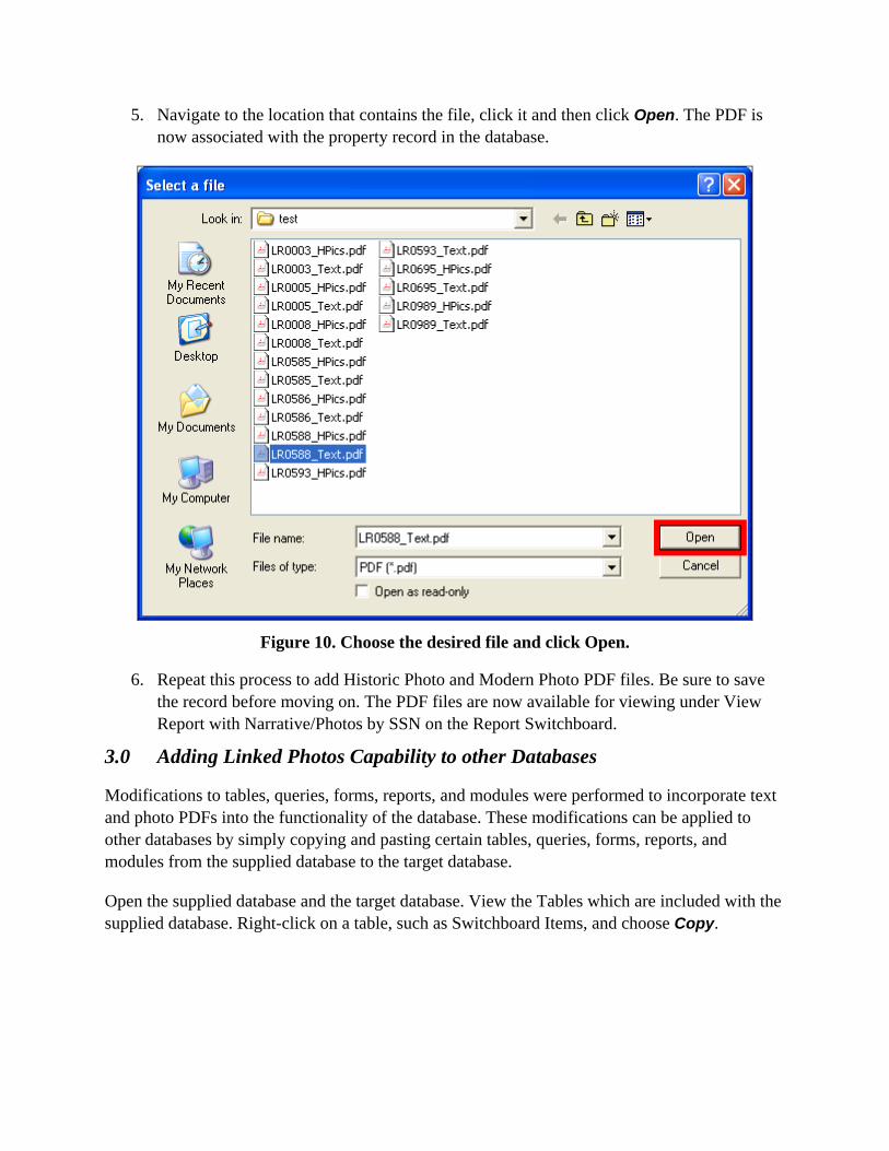
5. Navigate to the location that contains the file, click it and then click Open. The PDF is now associated with the property record in the database.
Figure 10. Choose the desired file and click Open.
6. Repeat this process to add Historic Photo and Modern Photo PDF files. Be sure to save the record before moving on. The PDF files are now available for viewing under View Report with Narrative/Photos by SSN on the Report Switchboard.
3.0 Adding Linked Photos Capability to other Databases
Modifications to tables, queries, forms, reports, and modules were performed to incorporate text and photo PDFs into the functionality of the database. These modifications can be applied to other databases by simply copying and pasting certain tables, queries, forms, reports, and modules from the supplied database to the target database.
Open the supplied database and the target database. View the Tables which are included with the supplied database. Right-click on a table, such as Switchboard Items, and choose Copy.
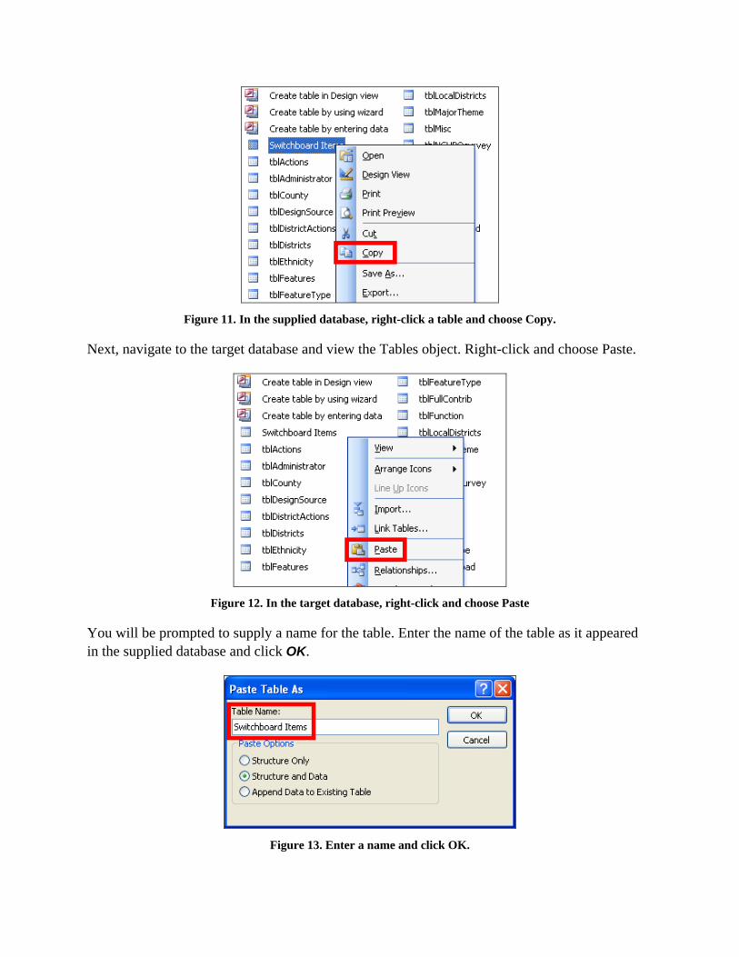
Figure 11. In the supplied database, right-click a table and choose Copy.
Next, navigate to the target database and view the Tables object. Right-click and choose Paste.
Figure 12. In the target database, right-click and choose Paste
You will be prompted to supply a name for the table. Enter the name of the table as it appeared in the supplied database and click OK.
Figure 13. Enter a name and click OK.
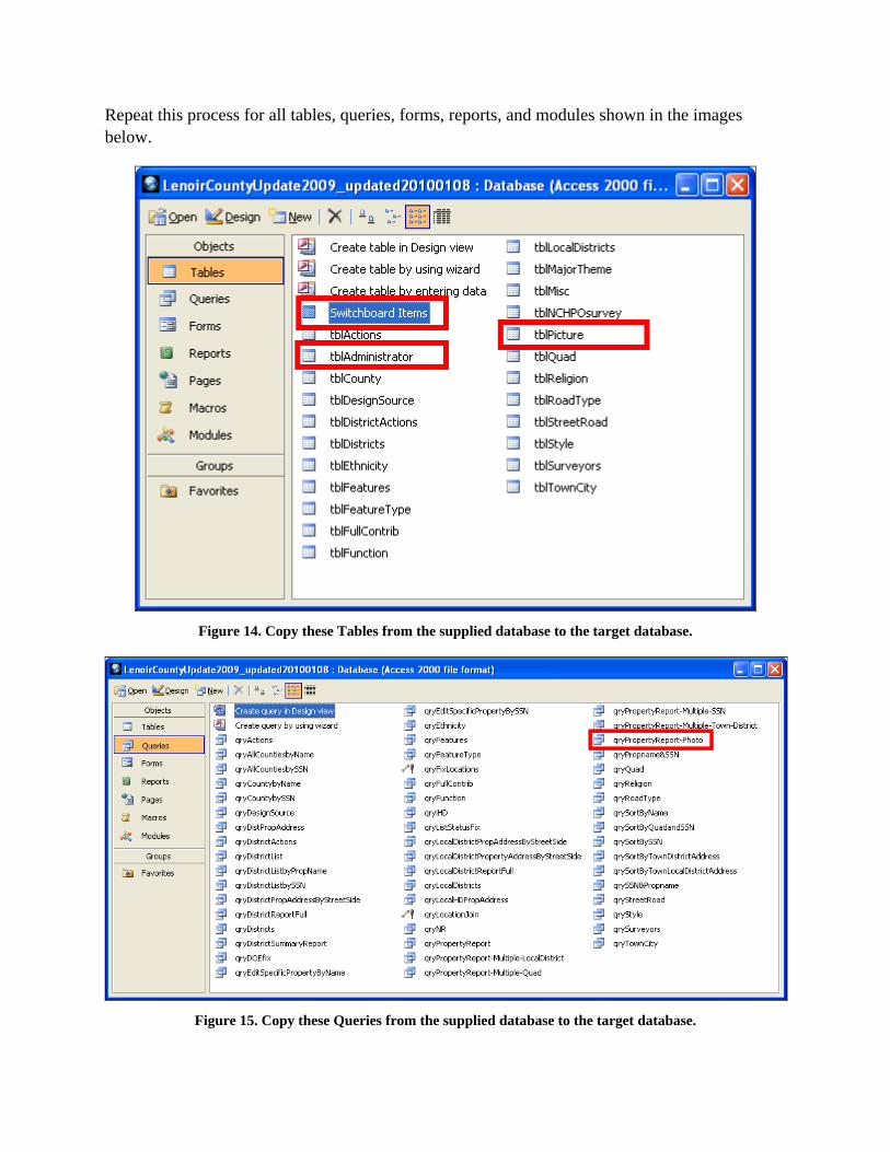
Repeat this process for all tables, queries, forms, reports, and modules shown in the images below.
Figure 14. Copy these Tables from the supplied database to the target database.
Figure 15. Copy these Queries from the supplied database to the target database.
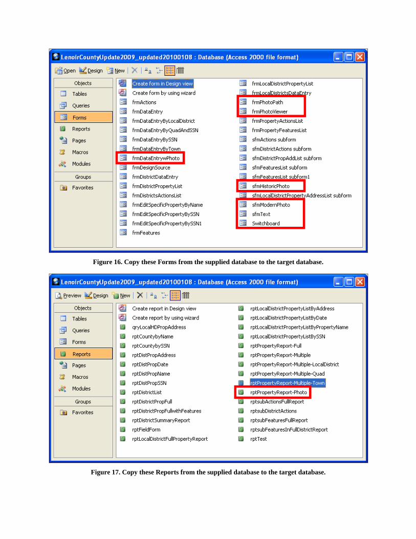
Figure 16. Copy these Forms from the supplied database to the target database.
Figure 17. Copy these Reports from the supplied database to the target database.
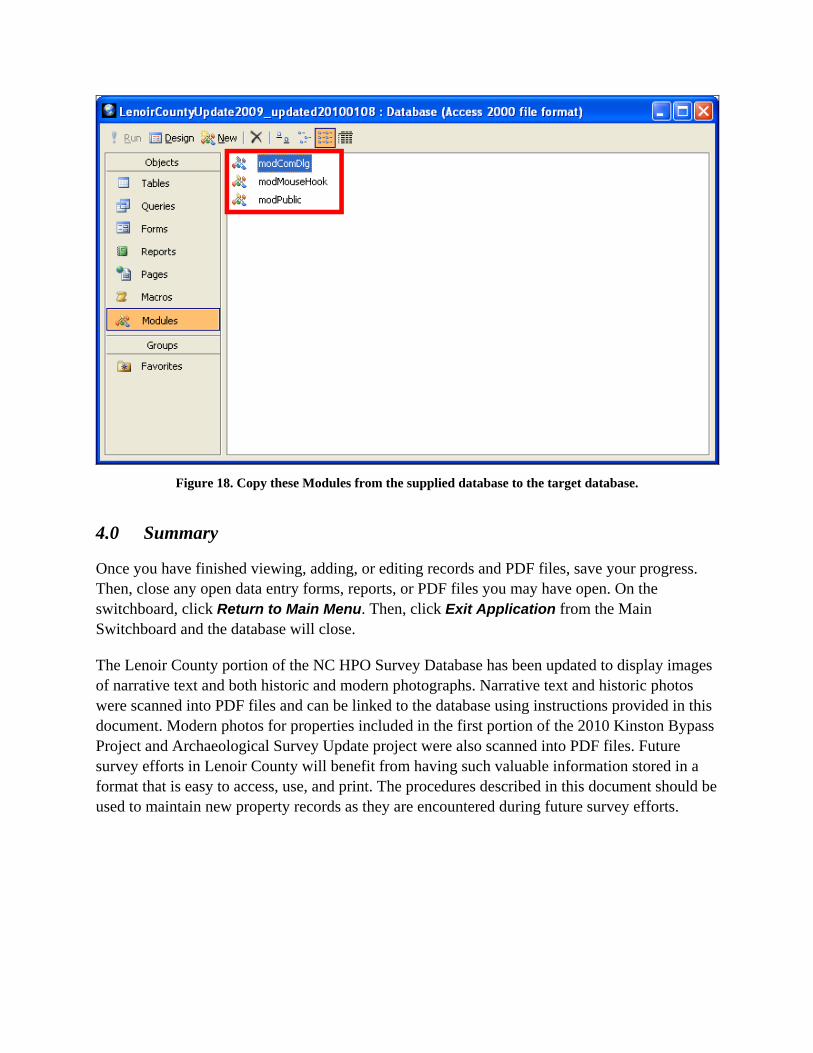
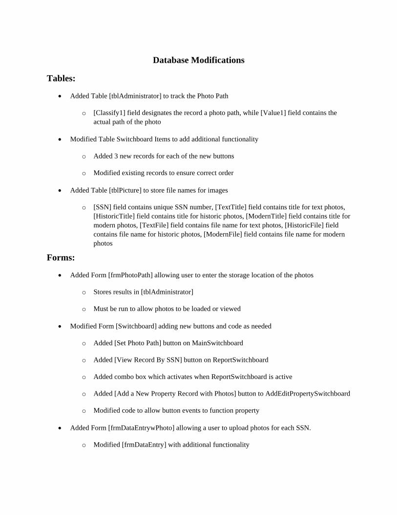
Figure 18. Copy these Modules from the supplied database to the target database.
4.0 Summary
Once you have finished viewing, adding, or editing records and PDF files, save your progress. Then, close any open data entry forms, reports, or PDF files you may have open. On the switchboard, click Return to Main Menu. Then, click Exit Application from the Main Switchboard and the database will close.
The Lenoir County portion of the NC HPO Survey Database has been updated to display images of narrative text and both historic and modern photographs. Narrative text and historic photos were scanned into PDF files and can be linked to the database using instructions provided in this document. Modern photos for properties included in the first portion of the 2010 Kinston Bypass Project and Archaeological Survey Update project were also scanned into PDF files. Future survey efforts in Lenoir County will benefit from having such valuable information stored in a format that is easy to access, use, and print. The procedures described in this document should be used to maintain new property records as they are encountered during future survey efforts.
Database Modifications
Tables:
• Added Table [tblAdministrator] to track the Photo Path
o [Classify1] field designates the record a photo path, while [Value1] field contains the actual path of the photo
• Modified Table Switchboard Items to add additional functionality
o Added 3 new records for each of the new buttons
o Modified existing records to ensure correct order
• Added Table [tblPicture] to store file names for images
o [SSN] field contains unique SSN number, [TextTitle] field contains title for text photos, [HistoricTitle] field contains title for historic photos, [ModernTitle] field contains title for modern photos, [TextFile] field contains file name for text photos, [HistoricFile] field contains file name for historic photos, [ModernFile] field contains file name for modern photos
Forms:
• Added Form [frmPhotoPath] allowing user to enter the storage location of the photos
o Stores results in [tblAdministrator]
o Must be run to allow photos to be loaded or viewed
• Modified Form [Switchboard] adding new buttons and code as needed
o Added [Set Photo Path] button on MainSwitchboard
o Added [View Record By SSN] button on ReportSwitchboard
o Added combo box which activates when ReportSwitchboard is active
o Added [Add a New Property Record with Photos] button to AddEditPropertySwitchboard
o Modified code to allow button events to function property
• Added Form [frmDataEntrywPhoto] allowing a user to upload photos for each SSN.
o Modified [frmDataEntry] with additional functionality
o After entering a title and navigating to the appropriate file, access with prompt the user to verify upload. Once the upload is completed the record will be updated, there is no need to save after each upload
o Allows user to upload a pdf or image file for each of the photo types
o Stores all information in [tblPicture]
o If an SSN is not already in [tblPicture] the form will create one and allow photos to be uploaded
o Added a find button which will return the record for the corresponding SSN number
o Code was modified to be consistent with changes.
• Added Form [sfmText] to display text photos
o Is a subform to frmPhotoViewer, displays text photos
o Added Form [sfmHistoricPhoto] to display historic photos
o Is a subform to frmPhotoViewer, displays historic photos
o Added Form [sfmModernPhoto] to display modern photos
o Is a subform to frmPhotoViewer, displays modern photos
o Added Form [frmPhotoViewer] allowing the user to view all three types of photos
o Parent form to three child forms
o Utilizes the value passed in the Switchboard form to display results for user selected SSN number
Reports:
• Added Report [rptPropertyReport –Photos] Allowing the user to display a single SSN record with corresponding photos.
Modules:
• Added Module [modComDlg] which administers the open file dialog
• Added Module [modMouseHook] which controls the mouse wheel
• Added Module [modPublic] which sets a global variable for the photo path
APPENDIX C
INSERTING TEXT FROM HISTORIC FILES
The following instructions will assist in allowing a user to copy and paste text from a .pdf file to insert into the Historic database.
1. Scan the historic text reference into PDF format.
2. Open the historic PDF file with Adobe Acrobat.
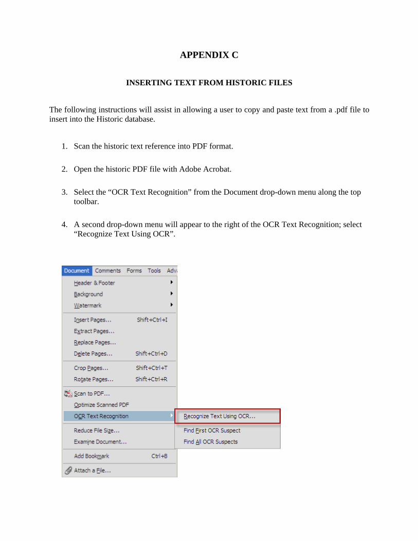
3. Select the “OCR Text Recognition” from the Document drop-down menu along the top toolbar.
4. A second drop-down menu will appear to the right of the OCR Text Recognition; select “Recognize Text Using OCR”.
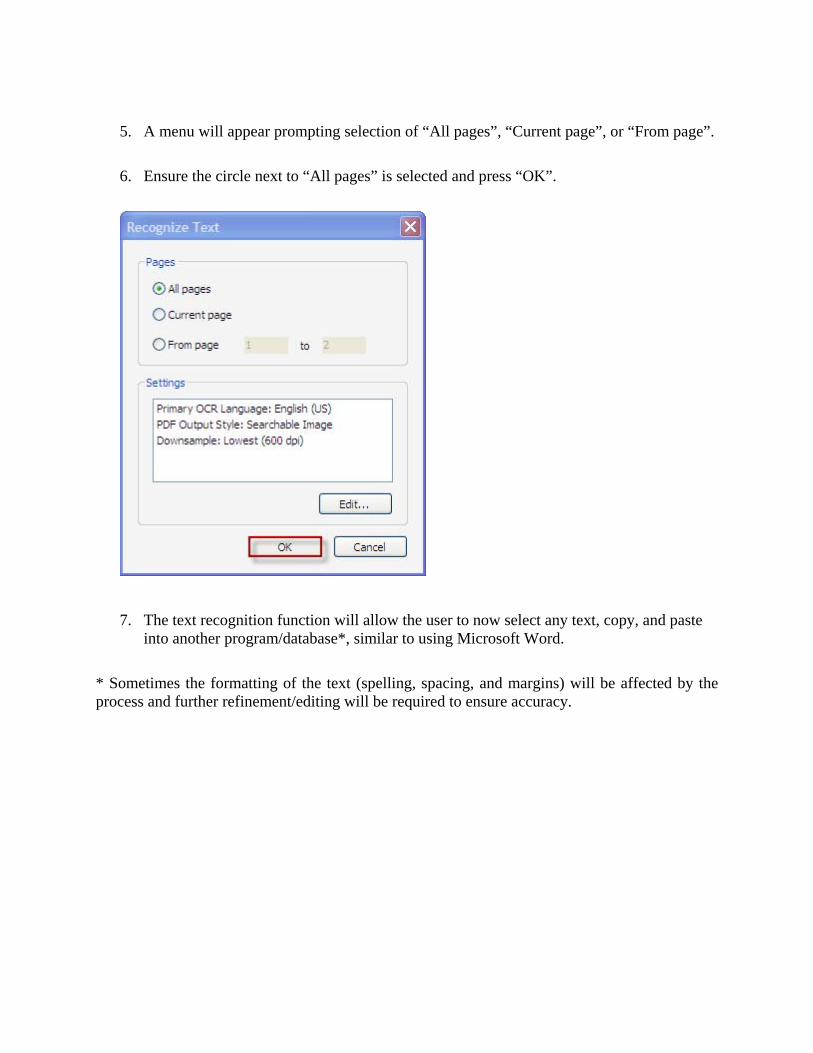
5. A menu will appear prompting selection of “All pages”, “Current page”, or “From page”.
6. Ensure the circle next to “All pages” is selected and press “OK”.
7. The text recognition function will allow the user to now select any text, copy, and paste into another program/database*, similar to using Microsoft Word.
* Sometimes the formatting of the text (spelling, spacing, and margins) will be affected by the process and further refinement/editing will be required to ensure accuracy.
Creating Historic and Modern Picture Files
The following instructions will assist in allowing a user to create Historic and Modern Picture files, condense them into a single .pdf file, label, and finally to insert into the Historic database.
Historic Photos
1. Scan and save any historic photos to a PDF format into a single folder with the label of which historic property (ie. LR0001_HPics).
2. Ensure you are running Adobe Acrobat on your computer, if not, a trial version can be downloaded from www.adobe.com
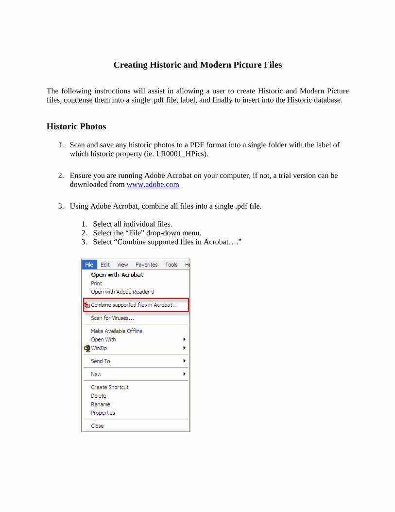
3. Using Adobe Acrobat, combine all files into a single .pdf file.
1. Select all individual files. 2. Select the “File” drop-down menu. 3. Select “Combine supported files in Acrobat….”
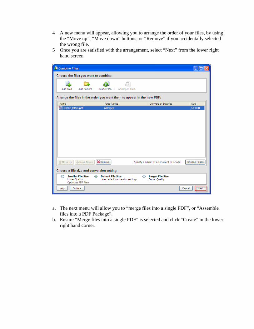
4 A new menu will appear, allowing you to arrange the order of your files, by using the “Move up”, “Move down” buttons, or “Remove” if you accidentally selected the wrong file.
5 Once you are satisfied with the arrangement, select “Next” from the lower right hand screen.
a. The next menu will allow you to “merge files into a single PDF”, or “Assemble files into a PDF Package”.
b. Ensure “Merge files into a single PDF” is selected and click “Create” in the lower right hand corner.
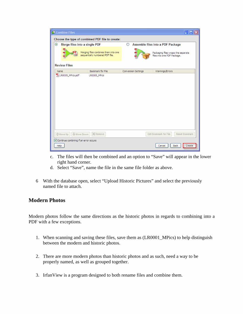
c. The files will then be combined and an option to “Save” will appear in the lower
right hand corner. d. Select “Save”, name the file in the same file folder as above.
6 With the database open, select “Upload Historic Pictures” and select the previously named file to attach.
Modern Photos
Modern photos follow the same directions as the historic photos in regards to combining into a PDF with a few exceptions.
1. When scanning and saving these files, save them as (LR0001_MPics) to help distinguish between the modern and historic photos.
2. There are more modern photos than historic photos and as such, need a way to be properly named, as well as grouped together.
3. IrfanView is a program designed to both rename files and combine them.
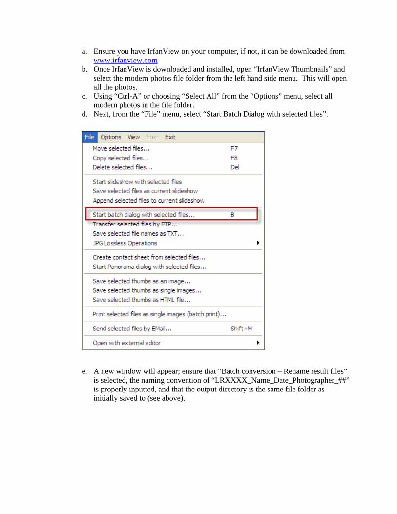
a. Ensure you have IrfanView on your computer, if not, it can be downloaded from www.irfanview.com
b. Once IrfanView is downloaded and installed, open “IrfanView Thumbnails” and select the modern photos file folder from the left hand side menu. This will open all the photos.
c. Using “Ctrl-A” or choosing “Select All” from the “Options” menu, select all modern photos in the file folder.
d. Next, from the “File” menu, select “Start Batch Dialog with selected files”.
e. A new window will appear; ensure that “Batch conversion – Rename result files” is selected, the naming convention of “LRXXXX_Name_Date_Photographer_##” is properly inputted, and that the output directory is the same file folder as initially saved to (see above).
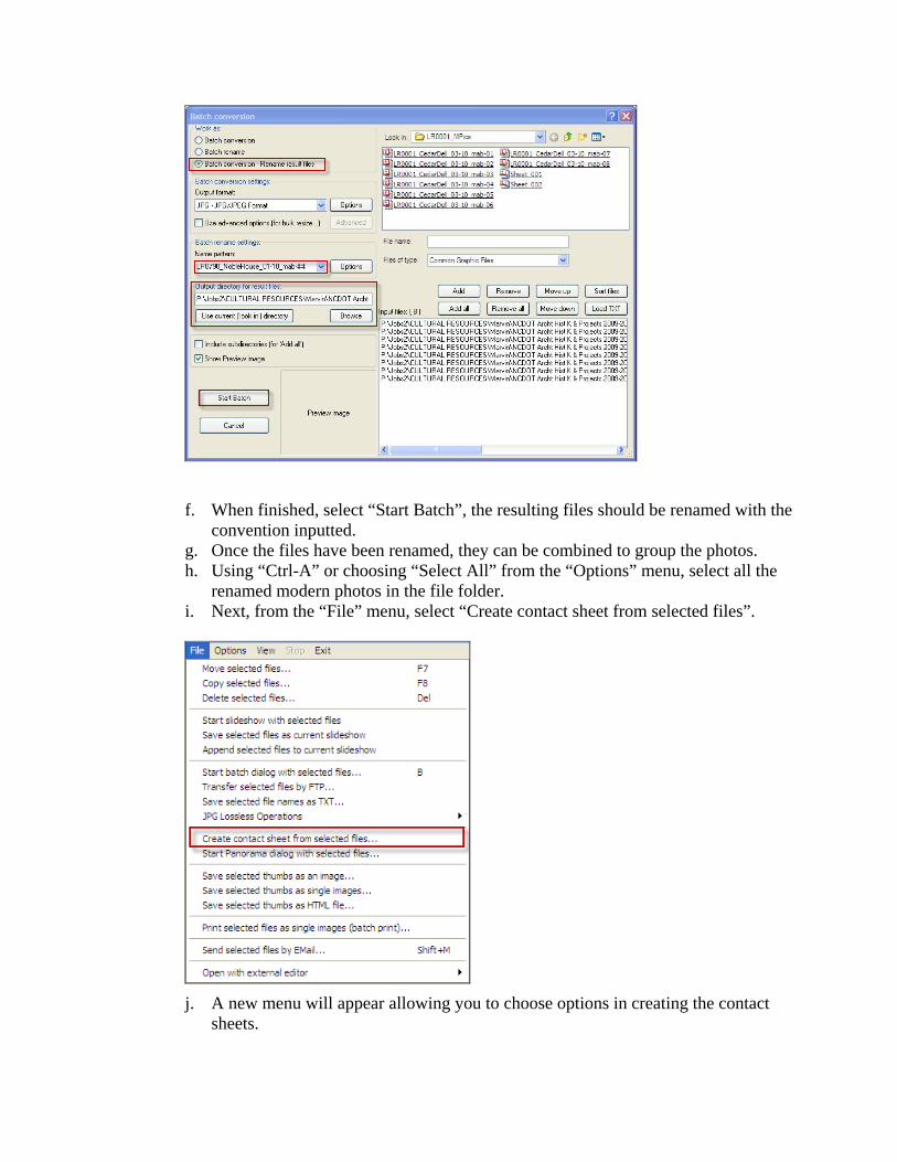
f. When finished, select “Start Batch”, the resulting files should be renamed with the convention inputted.
g. Once the files have been renamed, they can be combined to group the photos. h. Using “Ctrl-A” or choosing “Select All” from the “Options” menu, select all the
renamed modern photos in the file folder. i. Next, from the “File” menu, select “Create contact sheet from selected files”.
j. A new menu will appear allowing you to choose options in creating the contact
sheets.
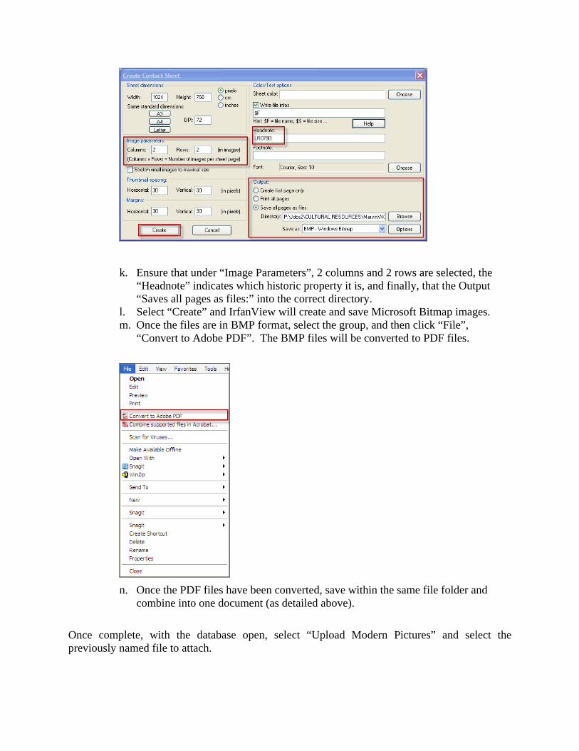
k. Ensure that under “Image Parameters”, 2 columns and 2 rows are selected, the “Headnote” indicates which historic property it is, and finally, that the Output “Saves all pages as files:” into the correct directory.
l. Select “Create” and IrfanView will create and save Microsoft Bitmap images. m. Once the files are in BMP format, select the group, and then click “File”,
“Convert to Adobe PDF”. The BMP files will be converted to PDF files.
n. Once the PDF files have been converted, save within the same file folder and
combine into one document (as detailed above).
Once complete, with the database open, select “Upload Modern Pictures” and select the previously named file to attach.