Embed Size (px)
Citation preview
Historical Land Survey RecordsPilot Project
Lorraine Wright, CPG, GISPRock Solid GIS
IGIC Cadastral, Boundaries, PLSS Workgroup Co-Chair
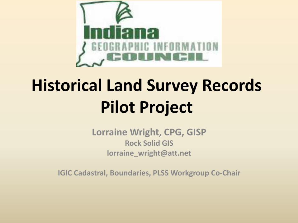
What is a Historical Land Survey Record
•It is a Surveyors’ field notes and plats that describe the boundaries of Township/Range and Sections of the Public Land Survey System (PLSS)
•Indiana was originally part of the Northwest Territory
•The Government contracted to have Surveyors survey the Territory and Grant Lands so land could be sold
Pilot Project
2/19/2016 Lorraine Wright, Rock Solid GIS IGIC Cadastral, Boundaries, PLSS Workgroup
Source: BLM

Land Survey Records = Surveying Field Notes and Plats
• Surveying was the first step towards distributing the land.
• Deputy surveyors took their instruments into the wilderness and, under miserable conditions, compiled their field notes: the complete description of the border lines of each section and the monuments marking the corners of the rectangular grid (PLSS). These notes often included cursory evaluations of the land itself, its agricultural potential, access to water or timber. types of trees, stream meanders and so on.
• From these notes, the surveyors compiled plats - or maps - graphic representations of the field notes for every township, with each section delineated, and roads, trails, rivers and streams marked.
Pilot Project
2/19/2016 Lorraine Wright, Rock Solid GIS IGIC Cadastral, Boundaries, PLSS Workgroup Source: BLM

Example of Field Book (Notes) - Photo 2/19/2016 Lorraine Wright, Rock Solid GIS IGIC Cadastral, Boundaries, PLSS Workgroup
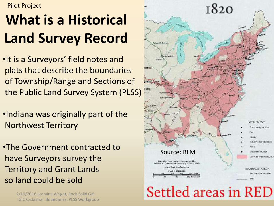
Map Showing•Base Line •Principal Meridian
and•Clarks’ Grant
Indiana RecordsDescribed by: • Township # Dir• Range # Dir
or • Grant and Lot #Source:BLM
Reference
2/19/2016 Lorraine Wright, Rock Solid GIS IGIC Cadastral, Boundaries,
PLSS Workgroup
W E
N
S W of PM01
Pilot Project

Indiana PM02 T2S R3W Sec 14
References
2/19/2016 Lorraine Wright, Rock Solid GIS IGIC Cadastral, Boundaries, PLSS Workgroup
Township is6 miles by 6 miles
or 480 Chains by 480 Chains
Section is1 mile by 1 mile

Survey Land Records • 1786 - 1789 – Clarks’ Grant surveys
• 1804 – 1883 - Land Survey Record Time frames – Original Field Notes– (pilot project)
• 1805 - Second Principal Meridian (PM02) Adopted – Majority of Indiana– Governing surveys -Illinois and Indiana. – Initial Point - Latitude 38-28-14, Longitude 86-27-21
• 1814 - First Principal Meridian (PM01) Adopted– Small portion of Eastern Indiana– Governing surveys - Ohio and Indiana– Initial Point - Latitude 40-59-22, Longitude 84-48-11
2/19/2016 Lorraine Wright, Rock Solid GIS IGIC Cadastral, Boundaries, PLSS Workgroup

Why are GIS Professionals Interested in Survey Records?
• GIS professionals map and analyze data. All the data relates to the Land System
• The IGIC Cadastral, Boundaries, PLSS Workgroup mission is to work with groups and compile the best set of data for Indiana’s Land System and make it available as a state-wide GIS layer(s) on IndianaMap
• Working with Surveyors is imperative to establish a good GIS for the Cadastral, Boundaries and PLSS layers
• We are all working with the same data but in different capacities for different reasons at different scales
• Makes sense to work together• Goal: Link Field Notes to T/R layer in IndianaMap
2/19/2016 Lorraine Wright, Rock Solid GIS IGIC Cadastral, Boundaries, PLSS Workgroup

What Makes the Historical Land Records Important
• Basis for Indiana’s Land Records System
• Every land transaction today relates back to the Original Land Survey Records.
• Valuable to Surveying, Forestry, Hydrology, Genealogy, History, GIS, and others because of the wealth of historical information
• One data source, many different functions
• Enables us to retrace our States’ history2/19/2016 Lorraine Wright, Rock Solid GIS IGIC Cadastral, Boundaries, PLSS Workgroup
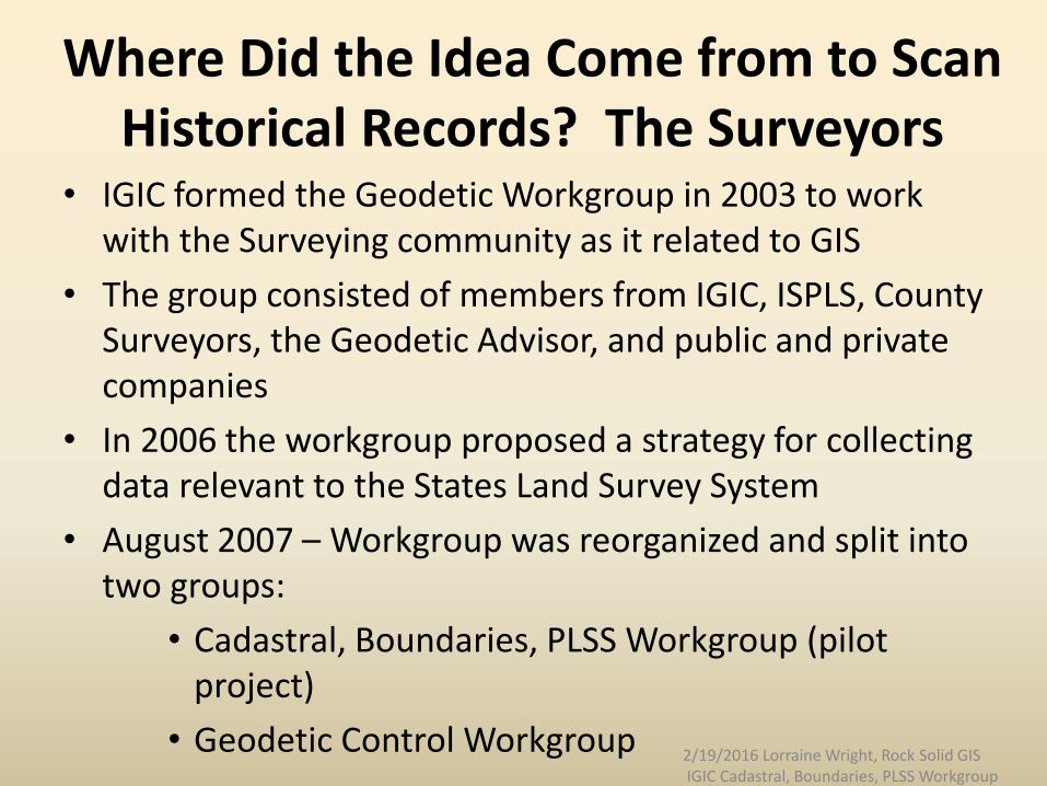
Where Did the Idea Come from to Scan Historical Records? The Surveyors
• IGIC formed the Geodetic Workgroup in 2003 to work with the Surveying community as it related to GIS
• The group consisted of members from IGIC, ISPLS, County Surveyors, the Geodetic Advisor, and public and private companies
• In 2006 the workgroup proposed a strategy for collecting data relevant to the States Land Survey System
• August 2007 – Workgroup was reorganized and split into two groups:
• Cadastral, Boundaries, PLSS Workgroup (pilot project)
• Geodetic Control Workgroup2/19/2016 Lorraine Wright, Rock Solid GIS IGIC Cadastral, Boundaries, PLSS Workgroup
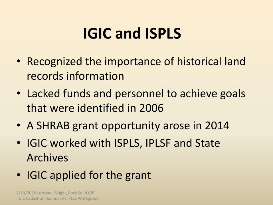
IGIC and ISPLS
• Recognized the importance of historical land records information
• Lacked funds and personnel to achieve goals that were identified in 2006
• A SHRAB grant opportunity arose in 2014
• IGIC worked with ISPLS, IPLSF and State Archives
• IGIC applied for the grant
2/19/2016 Lorraine Wright, Rock Solid GIS IGIC Cadastral, Boundaries, PLSS Workgroup
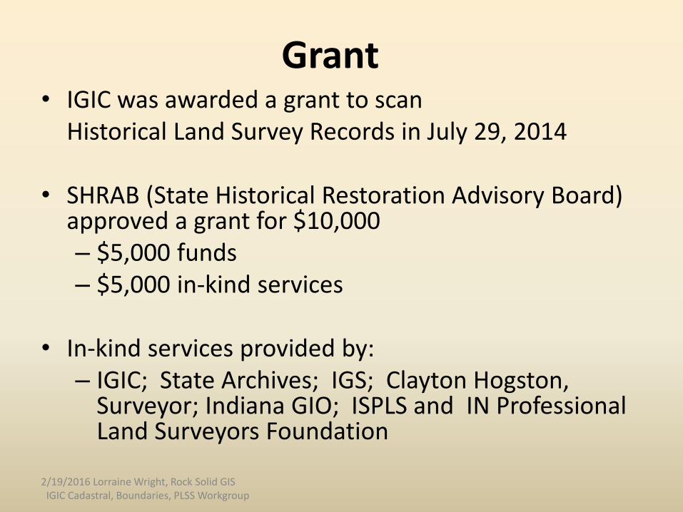
Grant• IGIC was awarded a grant to scan
Historical Land Survey Records in July 29, 2014
• SHRAB (State Historical Restoration Advisory Board) approved a grant for $10,000 – $5,000 funds– $5,000 in-kind services
• In-kind services provided by:– IGIC; State Archives; IGS; Clayton Hogston,
Surveyor; Indiana GIO; ISPLS and IN Professional Land Surveyors Foundation
2/19/2016 Lorraine Wright, Rock Solid GISIGIC Cadastral, Boundaries, PLSS Workgroup
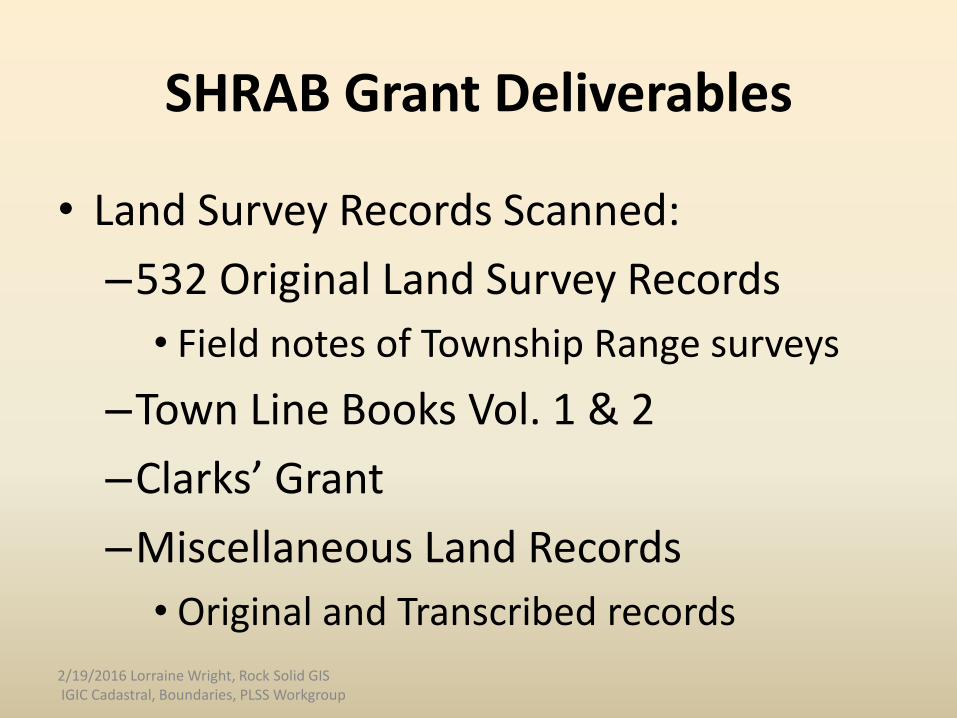
SHRAB Grant Deliverables
• Land Survey Records Scanned:
–532 Original Land Survey Records
• Field notes of Township Range surveys
–Town Line Books Vol. 1 & 2
–Clarks’ Grant
–Miscellaneous Land Records
• Original and Transcribed records
2/19/2016 Lorraine Wright, Rock Solid GIS IGIC Cadastral, Boundaries, PLSS Workgroup
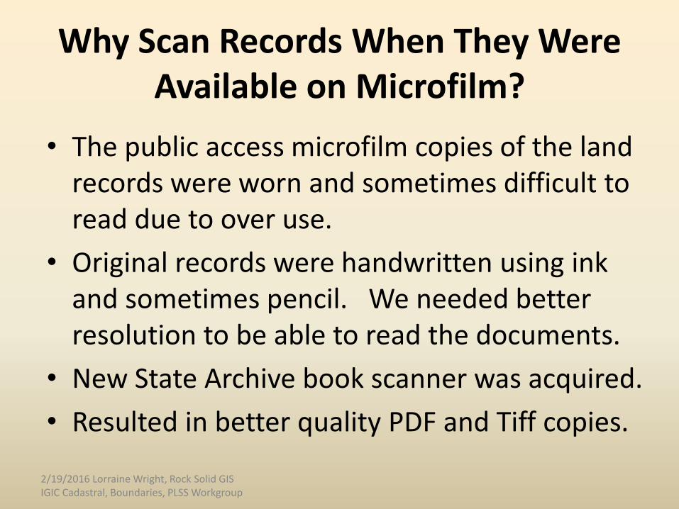
Why Scan Records When They Were Available on Microfilm?
• The public access microfilm copies of the land records were worn and sometimes difficult to read due to over use.
• Original records were handwritten using ink and sometimes pencil. We needed better resolution to be able to read the documents.
• New State Archive book scanner was acquired.
• Resulted in better quality PDF and Tiff copies.
2/19/2016 Lorraine Wright, Rock Solid GIS IGIC Cadastral, Boundaries, PLSS Workgroup

Four Types of Land Survey Records1. Original Field Survey Notes
Originally written by the Surveyor in field
Available at the State Archives (30%)
Pilot Project
2. Federal Notes
Transcribed by the GLO
Available at the National Archives
Clayton Hogston created digital dataset
3. State Notes
Transcribed by the GLO
Available at the State Archives
4. County Notes
Transcribed by the State Auditor
Available at the County Surveyor’s
Office Source: Clayton Hogston, Indiana Surveyor
White = Original Notes on microfilm
2/19/2016 Lorraine Wright, Rock Solid GISIGIC Cadastral, Boundaries, PLSS Workgroup
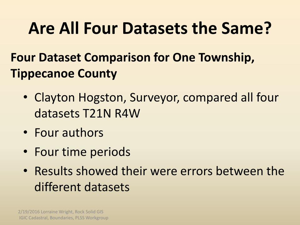
• Clayton Hogston, Surveyor, compared all four datasets T21N R4W
• Four authors
• Four time periods
• Results showed their were errors between the different datasets
2/19/2016 Lorraine Wright, Rock Solid GIS IGIC Cadastral, Boundaries, PLSS Workgroup
Are All Four Datasets the Same?
Four Dataset Comparison for One Township, Tippecanoe County
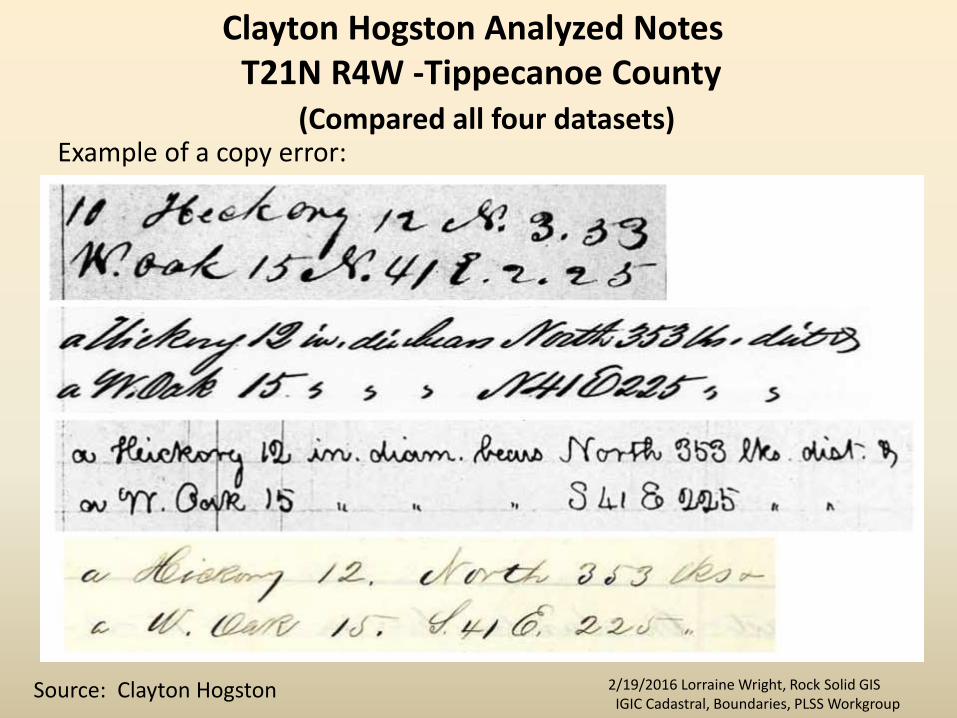
Clayton Hogston Analyzed Notes T21N R4W -Tippecanoe County
(Compared all four datasets)Example of a copy error:
Source: Clayton Hogston 2/19/2016 Lorraine Wright, Rock Solid GISIGIC Cadastral, Boundaries, PLSS Workgroup

Clayton Hogston Analyzed Notes
• Results of study:– T21N-R4W contains
– 28 data conflicts
• Total number of errors by set:– Original 3
– Federal 9
– State 16
– County 21
2/19/2016 Lorraine Wright, Rock Solid GIS IGIC Cadastral, Boundaries, PLSS Workgroup
Source: Clayton Hogston

Process Steps for Scanning Historic Land Records
1. Develop File Naming Convention2. Compile Reference Material3. Paper Inventory of Files4. Document Preparation5. Scan6. Name Files7. Name Folders8. Combine CSV Files9. Create Access Database10. Quality Control/Quality Assurance11. File Naming Evolution12. Review Time 2/19/2016 Lorraine Wright, Rock Solid GIS
IGIC Cadastral, Boundaries, PLSS Workgroup
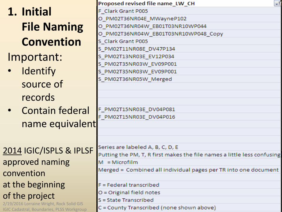
1. InitialFile Naming Convention
Important: • Identify
source of records
• Contain federal name equivalent
2014 IGIC/ISPLS & IPLSF approved naming conventionat the beginning of the project2/19/2016 Lorraine Wright, Rock Solid GIS IGIC Cadastral, Boundaries, PLSS Workgroup
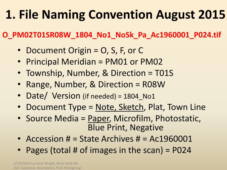
1. File Naming Convention August 2015
• Document Origin = O, S, F, or C• Principal Meridian = PM01 or PM02• Township, Number, & Direction = T01S• Range, Number, & Direction = R08W• Date/ Version (if needed) = 1804_No1
• Document Type = Note, Sketch, Plat, Town Line• Source Media = Paper, Microfilm, Photostatic,
Blue Print, Negative• Accession # = State Archives # = Ac1960001• Pages (total # of images in the scan) = P024
O_PM02T01SR08W_1804_No1_NoSk_Pa_Ac1960001_P024.tif
2/19/2016 Lorraine Wright, Rock Solid GIS IGIC Cadastral, Boundaries, PLSS Workgroup
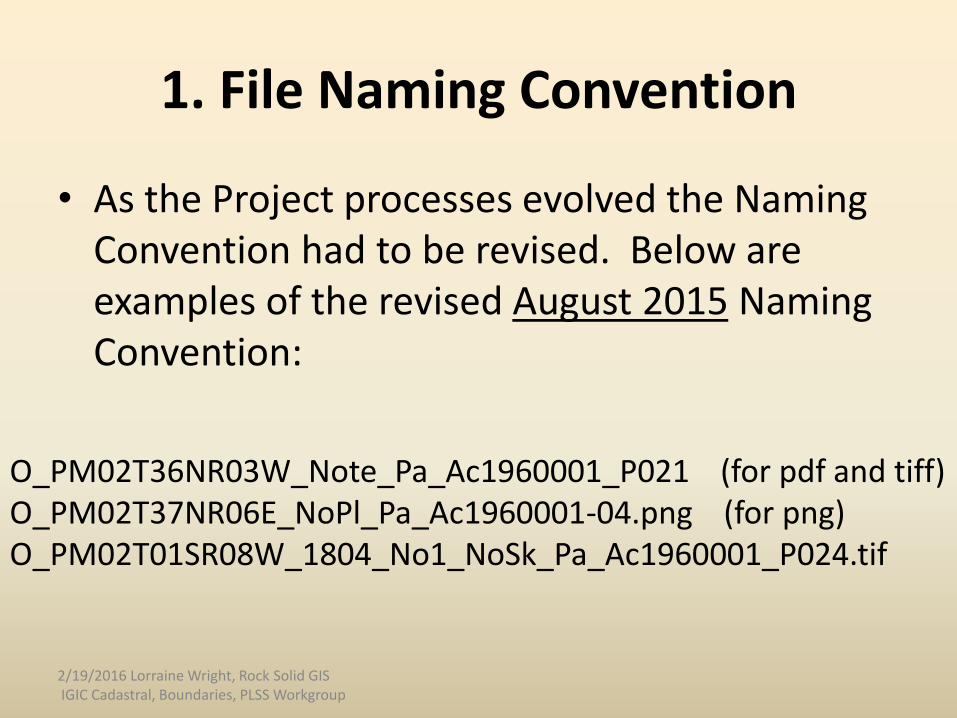
1. File Naming Convention
• As the Project processes evolved the Naming Convention had to be revised. Below are examples of the revised August 2015 Naming Convention:
O_PM02T36NR03W_Note_Pa_Ac1960001_P021 (for pdf and tiff)O_PM02T37NR06E_NoPl_Pa_Ac1960001-04.png (for png)O_PM02T01SR08W_1804_No1_NoSk_Pa_Ac1960001_P024.tif
2/19/2016 Lorraine Wright, Rock Solid GIS IGIC Cadastral, Boundaries, PLSS Workgroup
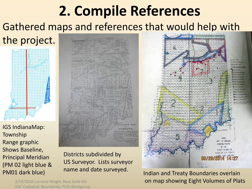
2. Compile ReferencesGathered maps and references that would help with the project.
Indian and Treaty Boundaries overlainon map showing Eight Volumes of Plats
Districts subdivided by US Surveyor. Lists surveyor name and date surveyed.
IGS IndianaMap:TownshipRange graphicShows Baseline, Principal Meridian(PM 02 light blue & PM01 dark blue)
2/19/2016 Lorraine Wright, Rock Solid GIS IGIC Cadastral, Boundaries, PLSS Workgroup
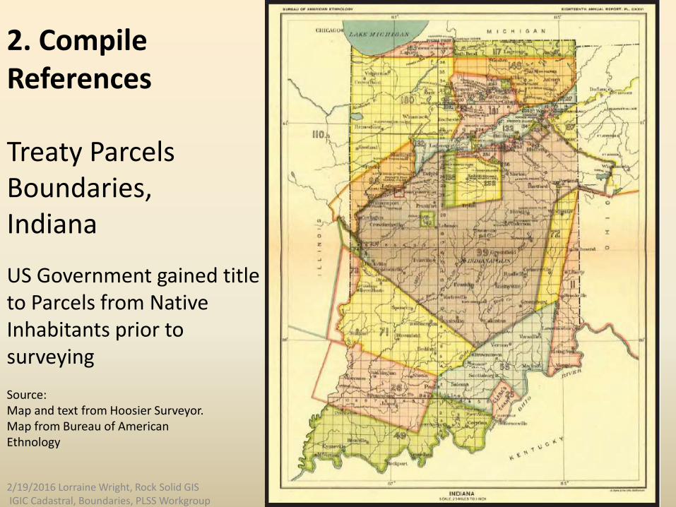
Treaty Parcels Boundaries,Indiana
US Government gained titleto Parcels from Native Inhabitants prior to surveying
Source:Map and text from Hoosier Surveyor.Map from Bureau of AmericanEthnology
2. Compile References
2/19/2016 Lorraine Wright, Rock Solid GIS IGIC Cadastral, Boundaries, PLSS Workgroup
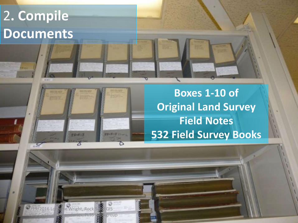
Boxes 1-10 of Original Land Survey
Field Notes532 Field Survey Books
2. Compile Documents
2/19/2016 Lorraine Wright, Rock Solid GIS IGIC Cadastral, Boundaries, PLSS Workgroup

Example of box label on box of microfilm
2. Compile Documents
2/19/2016 Lorraine Wright, Rock Solid GIS IGIC Cadastral, Boundaries, PLSS Workgroup
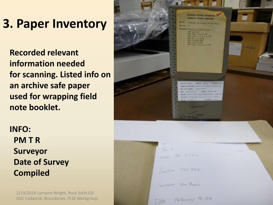
Recorded relevantinformation needed for scanning. Listed info on an archive safe paper used for wrapping field note booklet.
INFO:PM T RSurveyorDate of Survey Compiled
3. Paper Inventory
2/19/2016 Lorraine Wright, Rock Solid GIS IGIC Cadastral, Boundaries, PLSS Workgroup
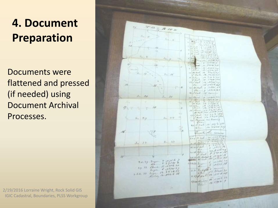
4. DocumentPreparation
Documents were flattened and pressed(if needed) usingDocument Archival Processes.
2/19/2016 Lorraine Wright, Rock Solid GISIGIC Cadastral, Boundaries, PLSS Workgroup
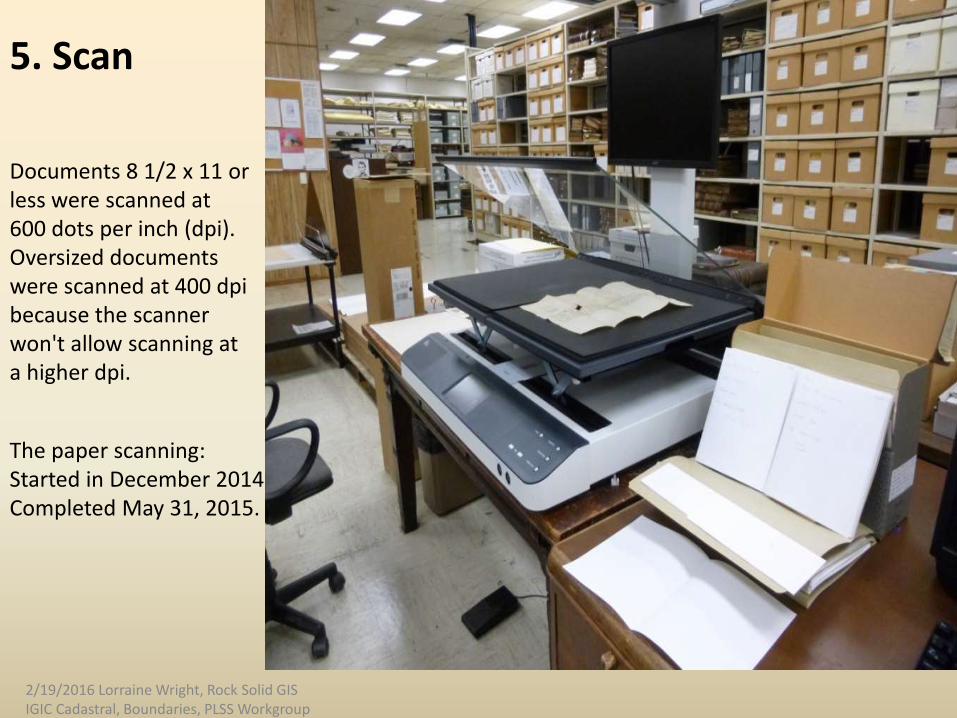
5. Scan
Documents 8 1/2 x 11 orless were scanned at 600 dots per inch (dpi). Oversized documents were scanned at 400 dpi because the scanner won't allow scanning ata higher dpi.
The paper scanning: Started in December 2014Completed May 31, 2015.
2/19/2016 Lorraine Wright, Rock Solid GIS IGIC Cadastral, Boundaries, PLSS Workgroup
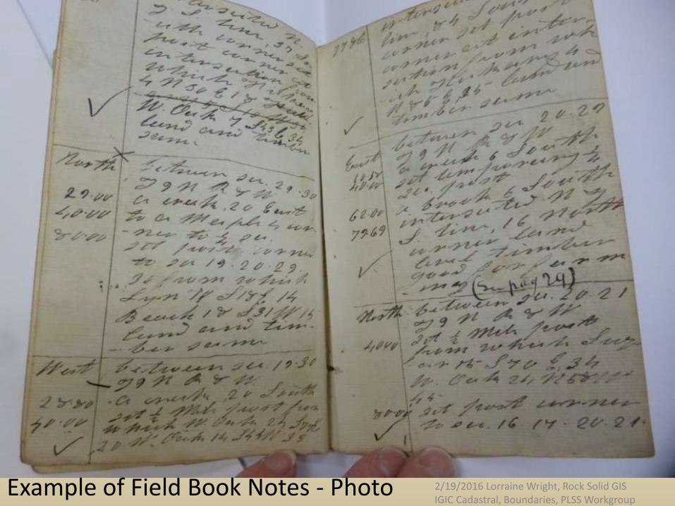
Example of Field Book Notes - Photo 2/19/2016 Lorraine Wright, Rock Solid GIS IGIC Cadastral, Boundaries, PLSS Workgroup
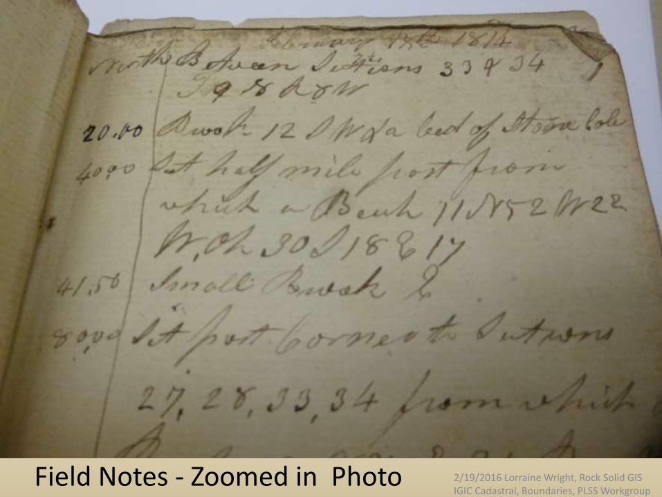
Field Notes - Zoomed in Photo 2/19/2016 Lorraine Wright, Rock Solid GIS IGIC Cadastral, Boundaries, PLSS Workgroup
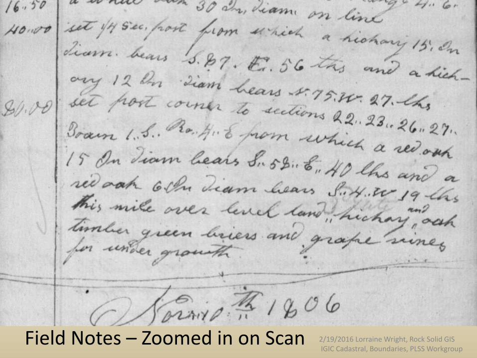
Field Notes – Zoomed in on Scan 2/19/2016 Lorraine Wright, Rock Solid GIS IGIC Cadastral, Boundaries, PLSS Workgroup

Field Notes – Zoomed in on Scan 2/19/2016 Lorraine Wright, Rock Solid GIS IGIC Cadastral, Boundaries, PLSS Workgroup
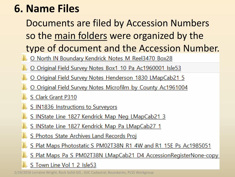
Documents are filed by Accession Numbers so the main folders were organized by the type of document and the Accession Number.
6. Name Files
2/19/2016 Lorraine Wright, Rock Solid GIS , IGIC Cadastral, Boundaries, PLSS Workgroup

Document folder Individual files are underwith sequence number each subfolder
6. Name Files: Book scanner automatically namedfiles during scanning.All single files were named
with the appropriate extension.
2/19/2016 Lorraine Wright, Rock Solid GIS IGIC Cadastral, Boundaries, PLSS Workgroup

Below are examples of the single page image thumbnails
(pngs) and a multi-page tif that had to be renamed.
6. Name Files
New Name =2/19/2016 Lorraine Wright, Rock Solid GIS
IGIC Cadastral, Boundaries, PLSS Workgroup
6. Name Files
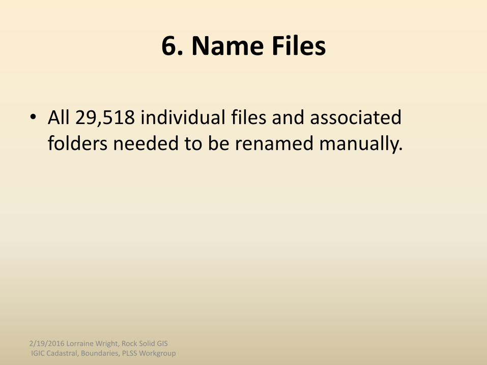
• All 29,518 individual files and associated folders needed to be renamed manually.
2/19/2016 Lorraine Wright, Rock Solid GIS IGIC Cadastral, Boundaries, PLSS Workgroup
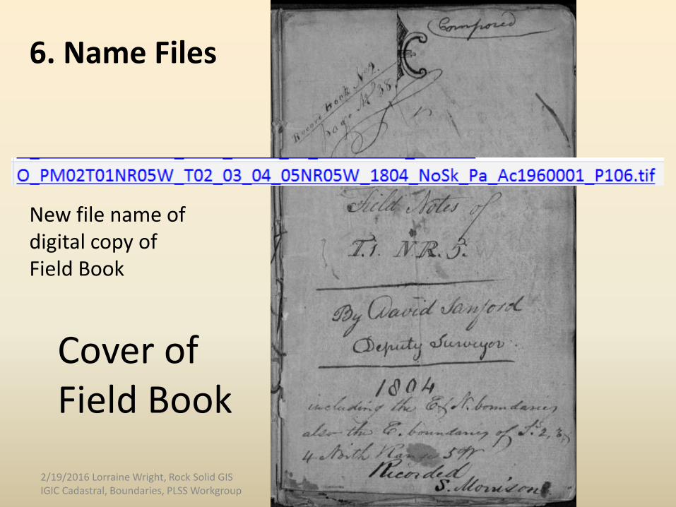
Cover of Field Book
New file name of digital copy ofField Book
6. Name Files
2/19/2016 Lorraine Wright, Rock Solid GIS IGIC Cadastral, Boundaries, PLSS Workgroup
6. Name Files
2/19/2016 Lorraine Wright, Rock Solid GIS IGIC Cadastral, Boundaries, PLSS Workgroup
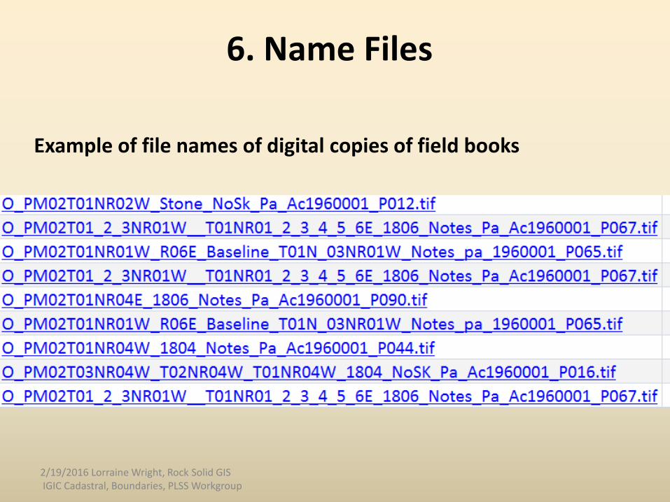
Example of file names of digital copies of field books
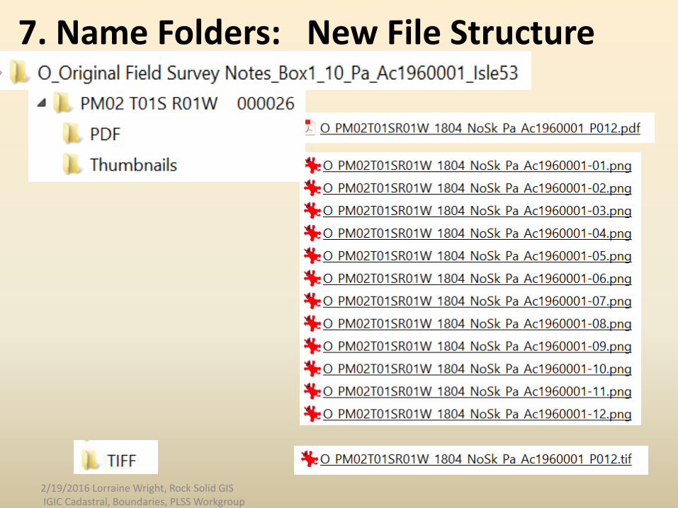
7. Name Folders: New File Structure
2/19/2016 Lorraine Wright, Rock Solid GIS IGIC Cadastral, Boundaries, PLSS Workgroup

8. Combined CSV Files Pertaining to Original Field Notes to Create Index File
• Csv files were created when the document was scanned
• Csv file contained information, typed in manually, from the paper inventory sheet
• There were 532 Field Books and 532 separate csv files
• All 532 csv files were combined and imported into an Access Database
2/19/2016 Lorraine Wright, Rock Solid GISIGIC Cadastral, Boundaries, PLSS Workgroup
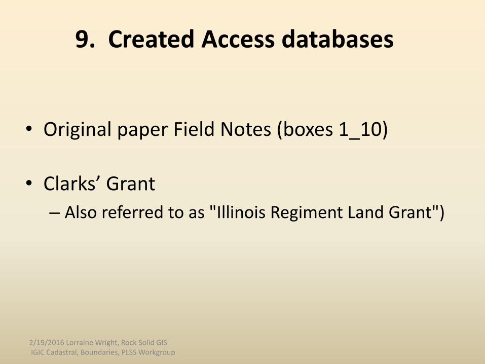
9. Created Access databases
• Original paper Field Notes (boxes 1_10)
• Clarks’ Grant
– Also referred to as "Illinois Regiment Land Grant")
2/19/2016 Lorraine Wright, Rock Solid GIS IGIC Cadastral, Boundaries, PLSS Workgroup
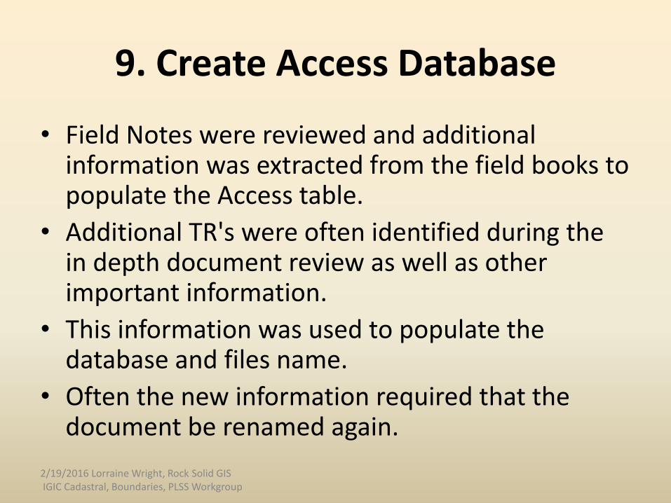
9. Create Access Database
• Field Notes were reviewed and additional information was extracted from the field books to populate the Access table.
• Additional TR's were often identified during the in depth document review as well as other important information.
• This information was used to populate the database and files name.
• Often the new information required that the document be renamed again.
2/19/2016 Lorraine Wright, Rock Solid GIS IGIC Cadastral, Boundaries, PLSS Workgroup

9. Access DatabaseSort by T R
2/19/2016 Lorraine Wright, Rock Solid GIS IGIC Cadastral, Boundaries, PLSS Workgroup
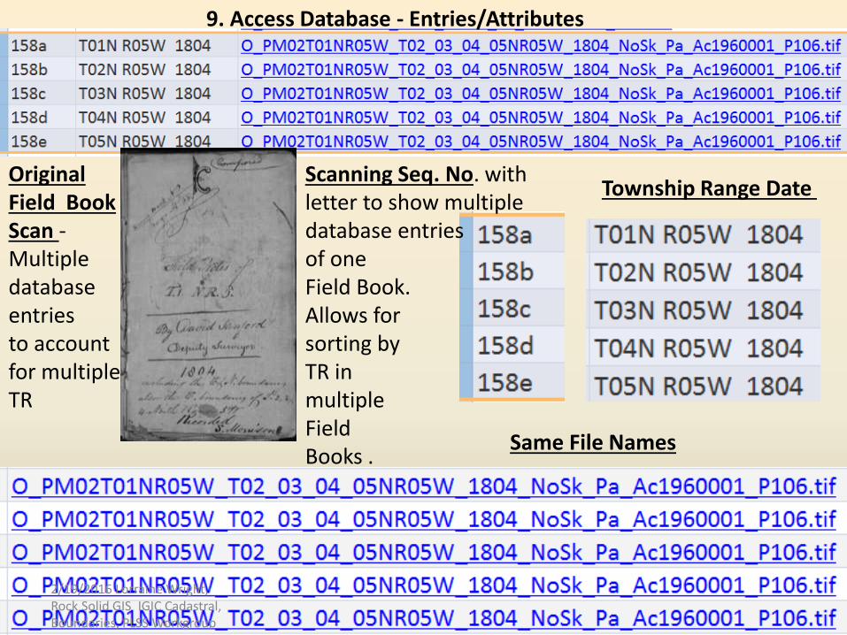
Scanning Seq. No. with letter to show multiple database entriesof oneField Book.Allows for sorting byTR in multipleField Books .
Township Range Date
Same File Names
OriginalField Book Scan -Multiple database entriesto accountfor multiple TR
9. Access Database - Entries/Attributes
2/19/2016 Lorraine Wright, Rock Solid GIS IGIC Cadastral, Boundaries, PLSS Workgroup
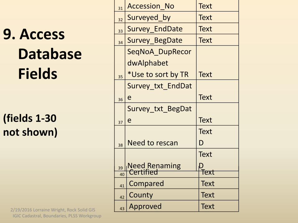
40 Certified Text
41 Compared Text
42 County Text
43 Approved Text
31 Accession_No Text
32 Surveyed_by Text
33 Survey_EndDate Text
34 Survey_BegDate Text
35
SeqNoA_DupRecor
dwAlphabet
*Use to sort by TR Text
36
Survey_txt_EndDat
e Text
37
Survey_txt_BegDat
e Text
38 Need to rescan
Text
D
39 Need Renaming
Text
D
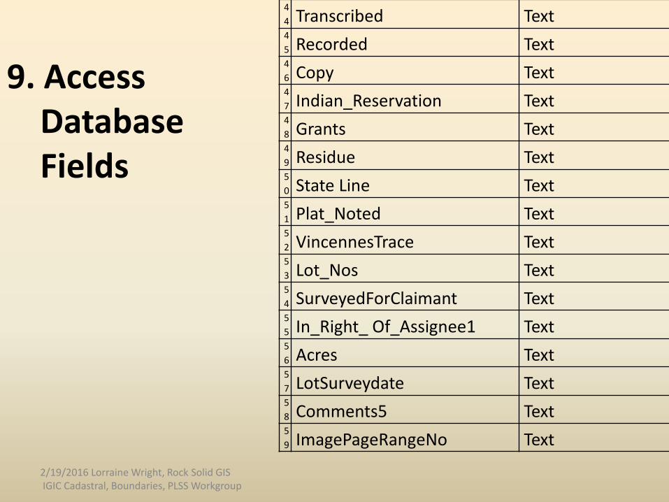
9. Access DatabaseFields
(fields 1-30not shown)
2/19/2016 Lorraine Wright, Rock Solid GISIGIC Cadastral, Boundaries, PLSS Workgroup
4
4 Transcribed Text4
5 Recorded Text4
6 Copy Text4
7 Indian_Reservation Text4
8 Grants Text4
9 Residue Text5
0 State Line Text5
1 Plat_Noted Text5
2 VincennesTrace Text5
3 Lot_Nos Text5
4 SurveyedForClaimant Text5
5 In_Right_ Of_Assignee1 Text5
6 Acres Text5
7 LotSurveydate Text5
8 Comments5 Text5
9 ImagePageRangeNo Text
9. Access DatabaseFields
2/19/2016 Lorraine Wright, Rock Solid GIS IGIC Cadastral, Boundaries, PLSS Workgroup

Significant Terms in Field Notes
compared
compared read first
compared read last
copied
copy
copy remeasurement
copy see original
corrections
defective
defective notes
duplicate copy
map
meanders
note index field sheet
original
original field notes
original plat made
recorded
recorded, resurvey
Resurveyed
Subdivisions (of T R)
Town Lines & Range Lines
Town Lines & Range Lines &
Subdivisions
survey of the morass
A true copy of the original
field notes
transcribed
true copy transcribed
variation of compass
Significant terms below were exacted from the Original Field Notes Versions. There may be multiple versions of a township/range document depending on the terms below. Info in database columns or comments.
2/19/2016 Lorraine Wright, Rock Solid GIS IGIC Cadastral, Boundaries, PLSS Workgroup
10. Quality Control/Quality Assurance
• In-depth review of the Field Notes revealed that the original cursory inventory sometimes needed to be revised due do additional information
• Creating a database was necessary to know which TR’s had multiple entries
• Database field’s were created to help in the QA/QC process
2/19/2016 Lorraine Wright, Rock Solid GIS IGIC Cadastral, Boundaries, PLSS Workgroup
11. File Naming Evolution
• New information gained from in-depth reviews often resulted in having to rename files several time.
• Finally it was determined the Access database needed to be populated first and then the files could be renamed.
• There were multiple Field Book (scans) that would reference a T R and it was difficult to differentiate them
• The file names expanded so that the TR documents could be differentiated.
2/19/2016 Lorraine Wright, Rock Solid GIS IGIC Cadastral, Boundaries, PLSS Workgroup
12. Review time
• Review time per document (doesn't included scanning or document preparation)
• The average time to process a document is about 2 to 2.5 hours
• Some may take less, 20 to 30 minutes, but some may require significantly more time.
• The more the township/ranges in the document the longer it takes to process.
• The quality of the hand writing also impacts the amount of time spent during the process.
• Future time estimates just for renaming and databases entries should be calculated at no fewer than 2.5 hours.
2/19/2016 Lorraine Wright, Rock Solid GISIGIC Cadastral, Boundaries, PLSS Workgroup
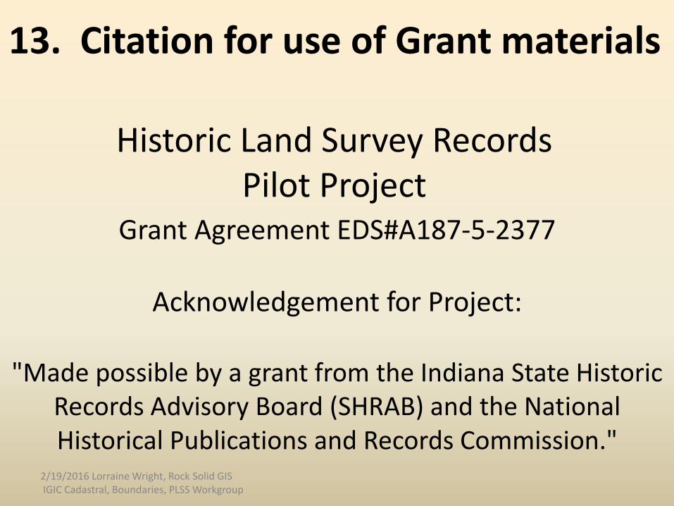
Grant Agreement EDS#A187-5-2377
Acknowledgement for Project:
"Made possible by a grant from the Indiana State Historic Records Advisory Board (SHRAB) and the National Historical Publications and Records Commission."
Historic Land Survey Records Pilot Project
13. Citation for use of Grant materials
2/19/2016 Lorraine Wright, Rock Solid GIS IGIC Cadastral, Boundaries, PLSS Workgroup

Summary• All scanning in the Grant is 100% complete• Project is only about 20% complete
– Approximately 80% of files need to be named– Approximately 80% of the database entries need completed– Additional databases (or database entrees needed for the other
Accessions)• Need addition funding and staff to complete• There are still files that need to be scanned that were not part of
the pilot project– Plats– Most of the State’s Transcribed Field Note Books– Many other documents relevant to the Land Records
• The databases created will make it much easier to find the information and the file names will help differentiate between different Field Books that relate to the same TR.
2/19/2016 Lorraine Wright, Rock Solid GIS IGIC Cadastral, Boundaries, PLSS Workgroup

Deliverables:Draft Map
Field Notes scanned -dark blue
(not all Townships, Grant Lots, and Indian Grant lands are shown)
2/19/2016 Lorraine Wright, Rock Solid GIS IGIC Cadastral, Boundaries, PLSS Workgroup
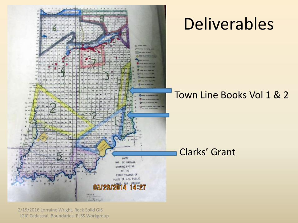
Deliverables
Town Line Books Vol 1 & 2
Clarks’ Grant
2/19/2016 Lorraine Wright, Rock Solid GISIGIC Cadastral, Boundaries, PLSS Workgroup
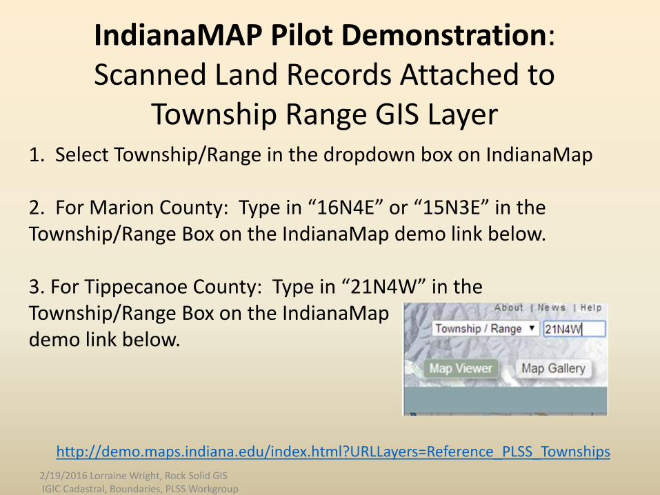
1. Select Township/Range in the dropdown box on IndianaMap
2. For Marion County: Type in “16N4E” or “15N3E” in the Township/Range Box on the IndianaMap demo link below.
3. For Tippecanoe County: Type in “21N4W” in the Township/Range Box on the IndianaMap demo link below.
IndianaMAP Pilot Demonstration: Scanned Land Records Attached to
Township Range GIS Layer
http://demo.maps.indiana.edu/index.html?URLLayers=Reference_PLSS_Townships
2/19/2016 Lorraine Wright, Rock Solid GIS IGIC Cadastral, Boundaries, PLSS Workgroup
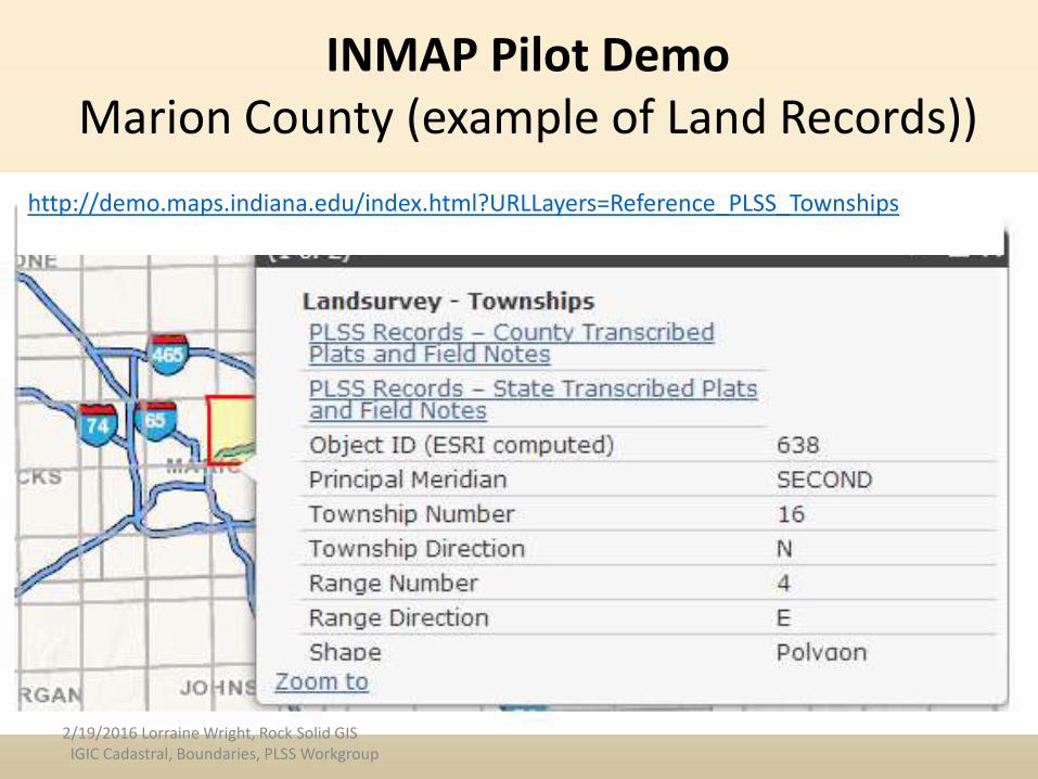
INMAP Pilot Demo Marion County (example of Land Records))
http://demo.maps.indiana.edu/index.html?URLLayers=Reference_PLSS_Townships
2/19/2016 Lorraine Wright, Rock Solid GISIGIC Cadastral, Boundaries, PLSS Workgroup
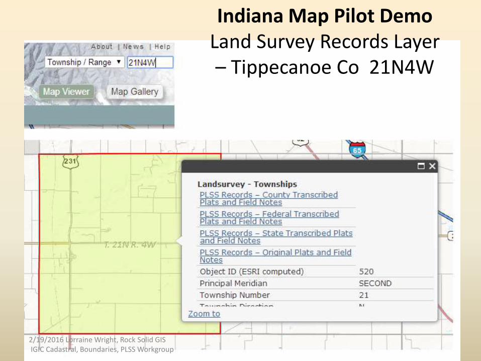
Indiana Map Pilot DemoLand Survey Records Layer – Tippecanoe Co 21N4W
2/19/2016 Lorraine Wright, Rock Solid GIS IGIC Cadastral, Boundaries, PLSS Workgroup
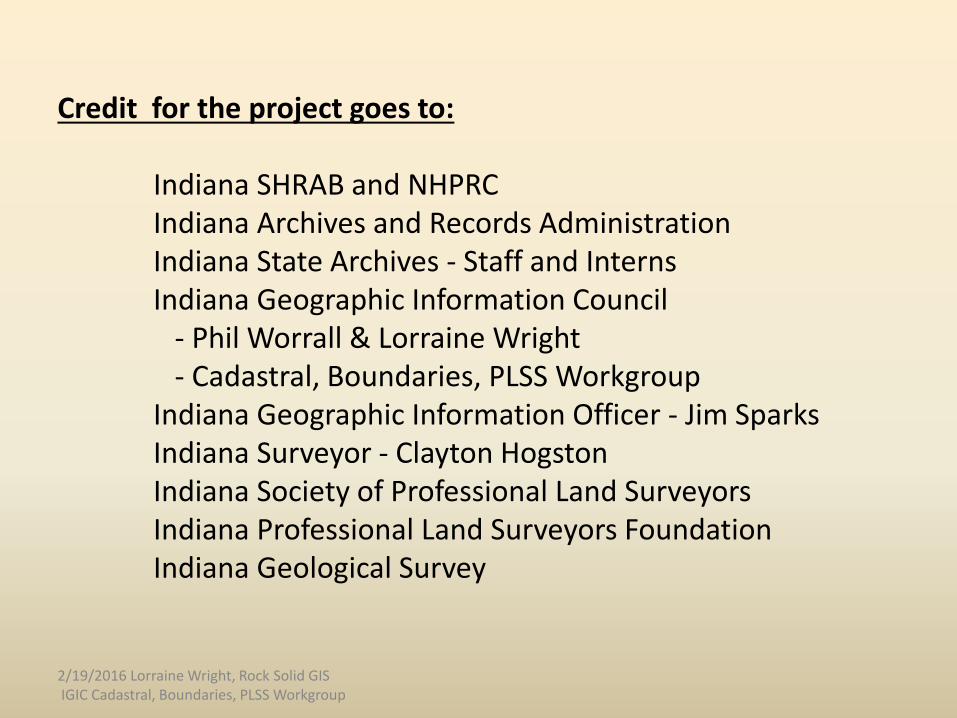
Credit for the project goes to:
Indiana SHRAB and NHPRCIndiana Archives and Records Administration Indiana State Archives - Staff and InternsIndiana Geographic Information Council
- Phil Worrall & Lorraine Wright- Cadastral, Boundaries, PLSS Workgroup
Indiana Geographic Information Officer - Jim SparksIndiana Surveyor - Clayton HogstonIndiana Society of Professional Land SurveyorsIndiana Professional Land Surveyors Foundation Indiana Geological Survey
2/19/2016 Lorraine Wright, Rock Solid GIS IGIC Cadastral, Boundaries, PLSS Workgroup

Historical Land Survey RecordsPilot Project
Lorraine Wright, CPG, GISPRock Solid GIS
IGIC Cadastral, Boundaries, PLSS Workgroup Co-Chair