Embed Size (px)
Citation preview

Archaeological investigation by fieldwalking and geophysical survey
at Gosbecks Business Park, Colchester,
Essex
September 2014
Report prepared by Mark Baister and
Tim Dennis
on behalf of Mr David Barbour
CAT project ref: 14/07d NGR: TL 97489 22624
Colchester museum accession code: 2014.92
Colchester Archaeological Trust Roman Circus House, Roman Circus Walk, Colchester, Essex CO2 7GZ Tel: 07436273304 E-mail: [email protected] CAT Report 792 November 2014
Contents 1. Summary 1 2. Introduction, aims, and methodology 1 3. Archaeological background 1 4. Fieldwalking survey 2 5. Geophysical Survey 4 6. Conclusions 7 7. Acknowledgements 7 8. References 8 9. Glossary and Abbreviations 8 10. Archive deposition 9 Appendix 1: Contents of archive Figures after p 9 List of Figures Fig 1 Site location. Fig 2 Fieldwalking grid. Fig 3 Fieldwalking results, showing post-medieval finds spots. Fig 4 Fieldwalking results, showing prehistoric to medieval finds spots. Fig 5 The site and adjacent archaeological park marker system. Fig 6 Magnetometer results image. Fig 7 Annotated magnetometer results.

CAT Report 792: An archaeological investigation by fieldwalking and geophysical survey, Gosbecks Business Park, Colchester, Essex: September 2014
1
1 Summary In advance of a proposed development, an evaluation by geophysical survey and fieldwalking was carried out on land to the west and south-west of Gosbecks Business Park, Colchester. The fieldwalking survey was carried out on the ploughed field to the south of Cunobelin Way (5.36ha). Finds were generally quite sparse, with the vast majority being of a post-medieval date (peg tile, clay pipe and pottery). The only earlier finds were one sherd of Roman pot, one sherd of medieval pot, one fragment of a lava quernstone, and 6 worked flints (of a mostly Neolithic date). The geophysical survey was carried out by Dr Tim Dennis on two fields to the north and south of Cunobelin Way (total of 3.42ha). This survey located very few anomalies, but may have picked up indications of the known Roman road running SW-NE across the site.
2 Introduction, aims, and methodology (Fig 1)
This is the archive report on an archaeological fieldwalking and geophysical survey carried out by the Colchester Archaeological Trust (CAT) on behalf of Mr David Barbour on land adjacent to Gosbecks Business Park, Colchester, Essex in September 2014.
The site lies to the south-west of Colchester town centre and south-west of Gosbecks Road, adjacent to Gosbecks Archaeological Park. The proposed development area lies outside the scheduled area associated with the park, but this archaeological investigation ventures into the scheduled area in an attempt to better tie in results from the fieldwalking and geophysics to known archaeological features (Fig 1). The site is centred at NGR TL 97489 22624.
A written scheme of investigation (WSI) was written by CAT on behalf of Mr David Barbour following the direction of a brief prepared by Chris Lister, Colchester Borough Council Archaeological Officer (July 2014). The archaeological brief was issued in response to the submitting of the site as a possible future residential development.
In addition to the WSI, all fieldwork and reporting was done in accordance with the CAT’s Policies and procedures (CAT 2008), Colchester Borough Council's Guidelines on standards and practices for archaeological fieldwork in the Borough of Colchester (CIMS 2008a) and Guidelines on the preparation and transfer of archaeological archives to Colchester and Ipswich Museums (CIMS 2008b), and the Institute for Field Archaeologists’ Standard and guidance for archaeological field evaluation (IfA 2008a) and Standard and guidance for the collection, documentation, conservation and research of archaeological materials (IfA 2008b). The guidance contained in the documents Management of Research Projects in the Historic Environment (MoRPHE), Standards for field archaeology in the East of England (EAA 14) and Research and archaeology revisited: A revised framework for the East of England (EAA 24) were also followed.
3 Archaeological background
There have been a number of excavations at Gosbecks, one of 2 recognised centres within the late Iron Age oppidum or proto-town of Camulodunum. The oppidum covered approximately 12 square miles of territory delineated by large defensive linear earthworks consisting of banks and ditches, known locally as dykes. Gosbecks was a major settlement and religious site for the Trinovantes during the Iron Age and continued in use into the Roman period, with the construction of a temple, fort and theatre.

CAT Report 792: An archaeological investigation by fieldwalking and geophysical survey, Gosbecks Business Park, Colchester, Essex: September 2014
2
Excavations carried out prior to 1995 are summarised in Hawkes and Crummy, (1995).In 1842 Jenkins uncovered parts of what he thought was a Roman villa, but was in fact the portico of the Roman temple. Following the discovery of the Colchester Mercury statuette, a number of small excavations were carried out which led to the discovery of the Roman theatre. In 1967, the theatre was partially excavated by Miss R Dunnett, and in 1977, small areas of the theatre and portico was examined to assess plough damage. In 1995-1996 excavations were carried out in advance of development on three sites near the northern edge of the Gosbecks Archaeological Park, (i.e. on the Maldon Road side: CAT Report 127). This revealed features of Late Iron Age to early Roman in date including a large ditched enclosure, and several pits. Early Roman military activity was recorded. Later a wooden water-main was laid across the area. Several Roman burials were also found, probably of later Roman date. Very little post-Roman activity was noted. Part of the Roman road from Gosbecks to the Roman town was examined on a separate site to the east (1995 Site A), four ditches in two pairs formed a central carriageway, approximately 7m wide with narrower tracks 2m wide on either side of the carriageway. The alignment of these ditches indicates that this was the link road between Gosbecks and the Roman town. It is this street that is present within the investigation area.
4 Fieldwalking survey (Figs 2-5)
Introduction and Method This is the report on the archaeological fieldwalking survey (FWS) carried out by Colchester Archaeological Trust (CAT) in September 2014. The FWS was one component part of the Gosbecks Business Park investigation. The other component (geophysical survey) is reported separately below (Section 5).
The survey was carried out in accordance with standard Essex fieldwalking methodology which has been used in Essex since the Stansted Project in 1986 (Havis and Brooks 2007), and was summarised by Medlycott (2005). The existing co-ordinate based grid on Gosbecks Archaeological Park was extended into the investigation area (Fig 5). Within each hectare, a 10% sample was achieved by collecting all surface finds from five parallel, 2-metre wide collection corridors spaced 20m apart, thus giving 25 collection units (or ‘stints’) in each hectare. However, because of the shape of the field, no complete hectare grids could be fitted onto the site, so the actual number of stints walked is lower than 25 per hectare. Finds were counted, and plotted on to a map base at a suitable scale, with one sheet showing post-medieval finds and one showing earlier finds. Because of the relative small size of the site and the general lack of finds (see below), the finds have not been weighed or quantified as being ‘significant’ or not based on their standard deviation from the mean weight. This was deemed to be of little use in interpretation. The total area walked was approximately 5.36 ha of arable farmland split into 11 hectare grids (Fig 2).
Grid stints area walked (ha)
1 6 0.24
2 14 0.56
3 6 0.24
4 4 0.16
5 20 0.8
6 18 0.72
7 10 0.4
8 5 0.2
9 14 0.56

CAT Report 792: An archaeological investigation by fieldwalking and geophysical survey, Gosbecks Business Park, Colchester, Essex: September 2014
3
10 20 0.8
11 17 0.68 total 134 5.36
Table 1: fieldwalking coverage by hectare grid
Results Prehistory (Fig 4) Prehistoric finds consisted of five worked flints and one possible flint core. No prehistoric pottery was recovered (not surprising, given its friability). None of the flints were in significant clusters – they were spread over the site. This assemblage contains some scrapers and flakes and all appear to be Neolithic. Roman (Fig 4) Roman finds consisted of one sherd of Colchester colour-coated pottery of 2nd-to 3rd-century date (in stint 2H). Also recovered was a fragment of lava quern, which could date from the Roman or medieval period. Anglo-Saxon No Anglo-Saxon finds were recovered. Medieval (Fig 4) Medieval finds consisted of one sherd of late medieval pottery, of a 15th-to 16th-century date (in stint 10L).
Post-medieval (Fig 3) There were three classes of post-medieval finds: pottery, clay pipe and tile (ie peg-tile). Twenty seven sherds of pottery, forty nine peg tile fragments and twenty fragments of clay pipe were recovered from across the investigation area. It is most likely that these finds are ‘manure scatter’ from Gosbecks Farm and do not indicate any post-medieval construction or occupation on the site.
Fieldwalking survey conclusions The worked flints recovered suggest some Neolithic activity pre-dating the late Iron Age oppidum, and fit in with the ‘general scatter of activity dating from the Mesolithic times onwards’ found throughout Colchester (Hawkes and Crummy, 1995). No prehistoric pottery was recovered but this is not necessarily indicative, because as mentioned above it is often very fragile and would not have survived well in regularly ploughed soil. The Roman and medieval finds are sparse, with only two sherds and one fragment of lava quern between them. The site is on the periphery of the Romano-British centre of Gosbecks, so the presence of only a small assemblage of Roman finds is not overly surprising. Likewise, the general lack of medieval finds is not unexpected in the context of the site being outside of the medieval town of Colchester.
CAT Report 792: An archaeological investigation by fieldwalking and geophysical survey, Gosbecks Business Park, Colchester, Essex: September 2014
4
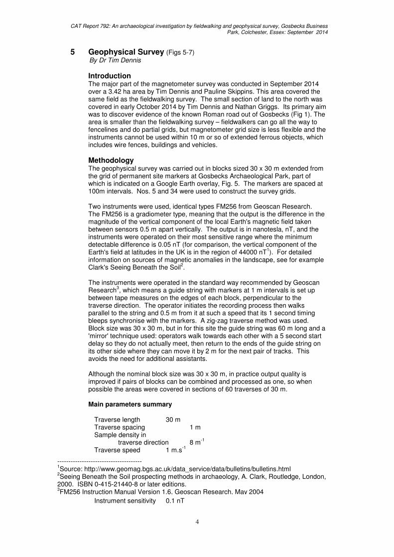
5 Geophysical Survey (Figs 5-7) By Dr Tim Dennis
Introduction The major part of the magnetometer survey was conducted in September 2014 over a 3.42 ha area by Tim Dennis and Pauline Skippins. This area covered the same field as the fieldwalking survey. The small section of land to the north was covered in early October 2014 by Tim Dennis and Nathan Griggs. Its primary aim was to discover evidence of the known Roman road out of Gosbecks (Fig 1). The area is smaller than the fieldwalking survey – fieldwalkers can go all the way to fencelines and do partial grids, but magnetometer grid size is less flexible and the instruments cannot be used within 10 m or so of extended ferrous objects, which includes wire fences, buildings and vehicles.
Methodology The geophysical survey was carried out in blocks sized 30 x 30 m extended from the grid of permanent site markers at Gosbecks Archaeological Park, part of which is indicated on a Google Earth overlay, Fig. 5. The markers are spaced at 100m intervals. Nos. 5 and 34 were used to construct the survey grids. Two instruments were used, identical types FM256 from Geoscan Research. The FM256 is a gradiometer type, meaning that the output is the difference in the magnitude of the vertical component of the local Earth's magnetic field taken between sensors 0.5 m apart vertically. The output is in nanotesla, nT, and the instruments were operated on their most sensitive range where the minimum detectable difference is 0.05 nT (for comparison, the vertical component of the Earth's field at latitudes in the UK is in the region of 44000 nT
1). For detailed
information on sources of magnetic anomalies in the landscape, see for example Clark's Seeing Beneath the Soil
2.
The instruments were operated in the standard way recommended by Geoscan Research
3, which means a guide string with markers at 1 m intervals is set up
between tape measures on the edges of each block, perpendicular to the traverse direction. The operator initiates the recording process then walks parallel to the string and 0.5 m from it at such a speed that its 1 second timing bleeps synchronise with the markers. A zig-zag traverse method was used. Block size was 30 x 30 m, but in for this site the guide string was 60 m long and a 'mirror' technique used: operators walk towards each other with a 5 second start delay so they do not actually meet, then return to the ends of the guide string on its other side where they can move it by 2 m for the next pair of tracks. This avoids the need for additional assistants. Although the nominal block size was 30 x 30 m, in practice output quality is improved if pairs of blocks can be combined and processed as one, so when possible the areas were covered in sections of 60 traverses of 30 m. Main parameters summary Traverse length 30 m Traverse spacing 1 m Sample density in traverse direction 8 m
-1
Traverse speed 1 m.s-1
Instrument sensitivity 0.1 nT
-------------------------------------- 1Source: http://www.geomag.bgs.ac.uk/data_service/data/bulletins/bulletins.html
2Seeing Beneath the Soil prospecting methods in archaeology, A. Clark, Routledge, London,
2000. ISBN 0-415-21440-8 or later editions. 3FM256 Instruction Manual Version 1.6, Geoscan Research, May 2004

CAT Report 792: An archaeological investigation by fieldwalking and geophysical survey, Gosbecks Business Park, Colchester, Essex: September 2014
5
Signal Processing The raw data samples are stored in the magnetometers, and subsequently downloaded. Data are saved in a single file in the order of capture, irrespective of the block structure of a survey. Software is Unix-based, and supports a range of geophysical survey data types with signal processing methods developed from experience with practical datasets. Processing uses some or all of the following stages. a. Extract data for individual survey block from instrument dump file. b. Alternate track reversal. Essential to correct for the zig-zag scanning format
of the survey. Assuming tracks are numbered from zero, tracks 1, 3... are reversed. Some data blocks are in addition reversed in the track direction to compensate for the 'mirror image' survey technique.
c. 'Destagger'. Usually required to correct for systematic operator- and direction-
dependent longitudinal positional offsets. d. A form of mean level subtraction. Essential. The instrument outputs the
difference in signal amplitude from its two fluxgate sensors; after initial thermal acclimatisation and alignment
4 this should be zero in an area of uniform
magnetic field, but there is typically a drift with time, usually a result of change in ambient air temperature, or differential heating, and hence distortion, of the instrument casing from exposure to sunlight.
A range of options is available:
i. Overall mean level subtraction. The minimum necessary. Guarantees the mean level of each data block will be zero, but unwanted variations within a block remain.
ii. Direction-dependent mean level subtraction. Odd and even track set averages computed and subtracted independently. This largely removes direction- and operator-dependent signal offsets.
iii. Direction-dependent smoothed track average mean level subtraction. Individual track averages are calculated, then the sets of values for odd and even tracks separately smoothed with a Gaussian lowpass filter, the 'standard deviation' of which specifies the width of the smoothing window. Values up to 2 are typical. A value of zero does no smoothing, so defaults to individual track average subtraction. This removes nearly all track-dependent variation, but also suppresses any 'real' feature that happens to be parallel to and longer than a track. A value of 1 is the typical compromise choice.
e. Post filtering. Optional, but useful in situations where 'genuine' anomalies have very low amplitude, which is common on gravel soils. The final output image for a block is generated from a weighted average of heavily smoothed and original pictures. The smoothing is done with circular-footprint Gaussian filters, where the 'standard deviation' measure is equivalent to 1 to 2 m. on the ground. Very approximately, the diameter of the smoothing window is hence 2-4m. Output = A.original + B.smoothed
-------------------------------------- 4Full procedure in FM256 manual, op. cit.
CAT Report 792: An archaeological investigation by fieldwalking and geophysical survey, Gosbecks Business Park, Colchester, Essex: September 2014
6
In normal usage, A + B = 1, but not required. For smoothing applications, typical values are A=0.3, B=0.7. These values mean that the video dynamic range for 'large' features (> 2-4 m in extent) is unaffected, but for small ones (<≈1 m) has amplitude multiplied by 0.3.
f. Output video level. A processed block is output as an uncompressed
greyscale image, where video levels are represented in 8 bit. Hence black is represented as 0, white 255. Internally, the signals are represented in signed double precision floating point. To convert to 8-bit video, the desired overall range is specified, e.g. 10 nT. This would be interpreted as -5nT to +5nT, with hard-limiting of values outside this range. This is then scaled to -128.0 to +127.0, and an offset of +128.0 added, which gives the normal video range in which magnetometer zero level is represented on the picture as mid grey. The values are converted to 8-bit unsigned integers in the range 0 to 255 for video. Specifying -10 nT range reverses the output contrast to what is usual for magnetometer imagery where +ve anomalies are typically black, -ve white.
g. Mosaic layout. Individual 'tiles' of the survey are assembled on a background which can contain a graticule, labelled axes, captions and other images. The output can have 'transparent' background if PNG or TIFF output image formats are selected.
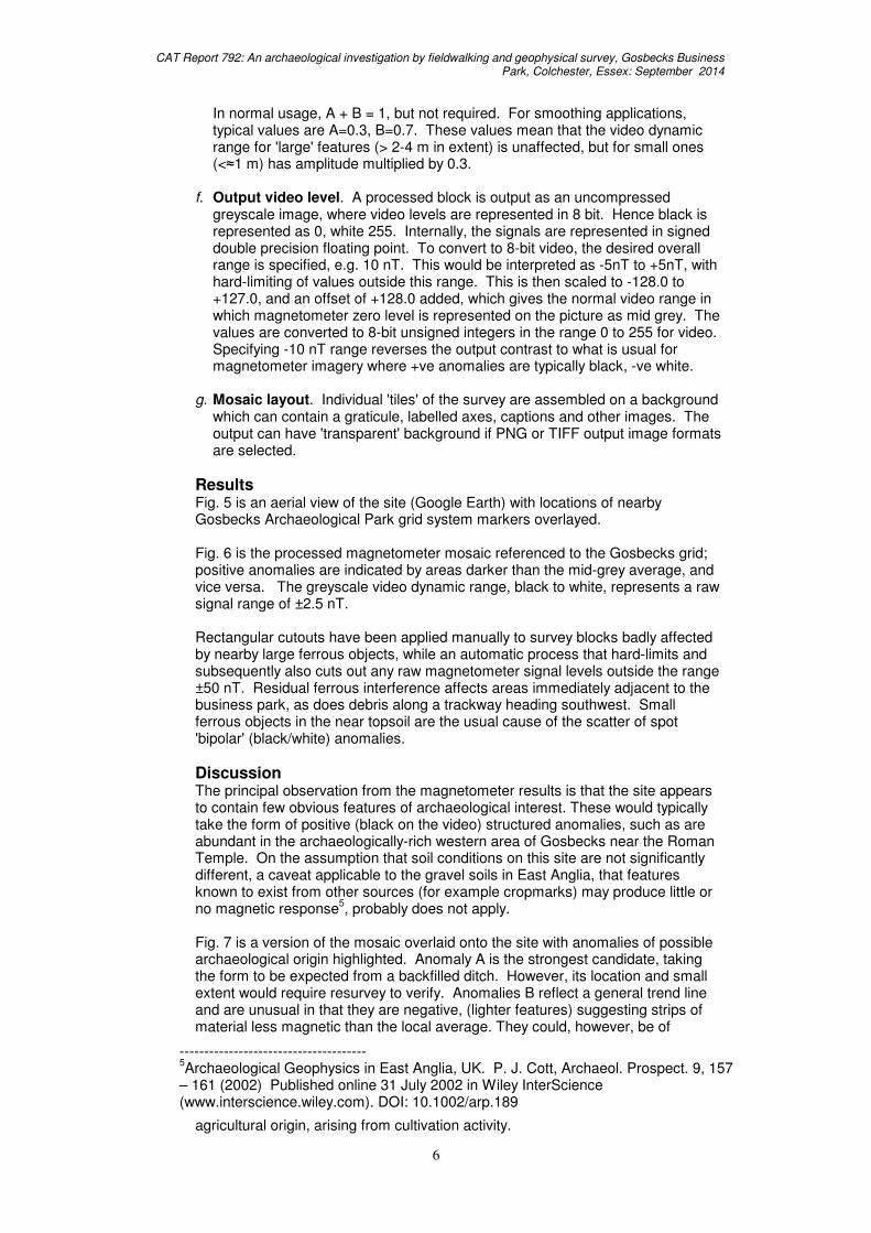
Results Fig. 5 is an aerial view of the site (Google Earth) with locations of nearby Gosbecks Archaeological Park grid system markers overlayed. Fig. 6 is the processed magnetometer mosaic referenced to the Gosbecks grid; positive anomalies are indicated by areas darker than the mid-grey average, and vice versa. The greyscale video dynamic range, black to white, represents a raw signal range of ±2.5 nT. Rectangular cutouts have been applied manually to survey blocks badly affected by nearby large ferrous objects, while an automatic process that hard-limits and subsequently also cuts out any raw magnetometer signal levels outside the range ±50 nT. Residual ferrous interference affects areas immediately adjacent to the business park, as does debris along a trackway heading southwest. Small ferrous objects in the near topsoil are the usual cause of the scatter of spot 'bipolar' (black/white) anomalies.
Discussion The principal observation from the magnetometer results is that the site appears to contain few obvious features of archaeological interest. These would typically take the form of positive (black on the video) structured anomalies, such as are abundant in the archaeologically-rich western area of Gosbecks near the Roman Temple. On the assumption that soil conditions on this site are not significantly different, a caveat applicable to the gravel soils in East Anglia, that features known to exist from other sources (for example cropmarks) may produce little or no magnetic response
5, probably does not apply.
Fig. 7 is a version of the mosaic overlaid onto the site with anomalies of possible archaeological origin highlighted. Anomaly A is the strongest candidate, taking the form to be expected from a backfilled ditch. However, its location and small extent would require resurvey to verify. Anomalies B reflect a general trend line and are unusual in that they are negative, (lighter features) suggesting strips of material less magnetic than the local average. They could, however, be of
agricultural origin, arising from cultivation activity.
-------------------------------------- 5Archaeological Geophysics in East Anglia, UK. P. J. Cott, Archaeol. Prospect. 9, 157
– 161 (2002) Published online 31 July 2002 in Wiley InterScience (www.interscience.wiley.com). DOI: 10.1002/arp.189

CAT Report 792: An archaeological investigation by fieldwalking and geophysical survey, Gosbecks Business Park, Colchester, Essex: September 2014
7
Elliptical anomaly C, 32 m diameter on its major axis, is very low contrast and could be an artifact. Anomalies D, E, F and G lie in the separate area to the north of the main site. D corresponds to deep wheel ruts in the modern ground surface. E may be the same, but F is a series of positive anomalies that are approximately parallel-to, but offset from, the Roman road crossing that part of the site. Positive anomaly G lies close to the track of the road. The road itself is not detected. A possible explanation lies in the nature of its ditches revealed in the 1995 evaluation (CAT report 127) which states that, '...they contained a fairly uniform silty sand over a gravelly fill in their base'. This suggests lack of significant organic matter, usually the principal cause of positive magnetic anomalies. The pair of small positive anomalies at H is an example of a type that can be found elsewhere on the site, including G above, sometimes appearing to have a structured distribution. These could be small pits ca. 1 m in diameter that have penetrated into the gravel subsoil and subsequently been backfilled by organic-rich topsoil. Their true significance, if any, can only be proved by excavation. The site everywhere is covered by a pattern of low-contrast aligned linear anomalies which are the results of recent and earlier patterns of cultivation.
6 Conclusions
The results of the fieldwalking were minimal. It exposed no concentration of finds indicative of intensive occupation in the Roman or medieval periods. A small assemblage of prehistoric worked flints were recovered, suggesting some background Neolithic activity in the area. The magnetometer survey contains a few minor anomalies that may be of interest, although these would all require excavation to fully ascertain if they were archaeological in nature. The Roman road known to cross the northern part of the investigation area (from the 1995 excavation detailed in CAT Report 127) was not identified. This suggests that other archaeological features may also not be visible on the magnetometer survey.
7 Acknowledgements
CAT is grateful to Mr David Barbour for commissioning the archaeological work. The fieldwork was managed by Mark Baister. Fieldwalking by M Baister, N Griggs and Felix Whymark. Geophysical survey by T Dennis, NG and P Skippins. Digital survey by MB, assisted by Robert Mathieson. Plans by MB (and TD for geophysical survey).

CAT Report 792: An archaeological investigation by fieldwalking and geophysical survey, Gosbecks Business Park, Colchester, Essex: September 2014
8
8 References
Note: all CAT reports, except for DBAs, are available online in .pdf format at http://cat.essex.ac.uk
CAR 11 1995 Colchester Archaeological Report 11: Camulodunum 2, by C F C Hawkes and P Crummy.
CAT 2008 CAT Report 127: Excavations of Late Iron Age and Roman features and a Roman road north of Gosbecks Archaeological Park, Colchester, Essex 1995-1996 by Stephen Benfield
CAT 2008 Policies and procedures
CAT 2014 Specification for archaeological geophysical survey at Gosbecks Farm/Business Centre, Colchester, Essex. July 2014 (Written Scheme of Investigation)
CIMS 2008a Guidelines on standards and practices for archaeological fieldwork in the Borough of Colchester
CIMS 2008b Guidelines on the preparation and transfer of archaeological archives to Colchester and Ipswich Museums
EAA 14 2003 Standards for field archaeology in the East of England East Anglian Archaeology, Occasional Papers, 14, ed by D Gurney
EAA 24 2011 Research and archaeology revisited: A revised framework for the East of England, East Anglian Archaeology Occasional Paper 24, ed. by Maria Medlycott
Havis, Richard, and Brooks, Howard
2004 Excavations at Stansted Airport, 1986-91. East Anglian Archaeology 107.
IfA 2008a Standard and guidance for an archaeological field evaluation
IfA 2008b Standard and guidance for the collection, documentation, conservation and research of archaeological materials
Lister, C 2014 Brief for Archaeological investigation by geophysical survey and field walking: Gosbecks Farm/Business Centre, Colchester, Essex. July 2014.
Medlycott, M 2005 ‘Archaeological fieldwalking in Essex, 1986-2005’, Essex Archaeology & History, 36, 1-9
MoRPHE 2006 Management of Research Projects in the Historic Environment (English Heritage)
9 Glossary and abbreviations Anglo-Saxon the period from c AD 410 to AD 1066 CAT Colchester Archaeological Trust CBC Colchester Borough Council CBM ceramic building material (brick, tile, tessera). context specific location of finds on an archaeological site ECC Essex County Council EHER Essex Historic Environment Record, held by Essex County
Council feature an identifiable thing like a pit, a wall, a floor; can contain
‘contexts’ fill the soil filling up a hole such as a pit or ditch HEA Historic Environment Advisor IfA Institute for Archaeologists layer an accumulation or deposition of archaeological material medieval the period from AD 1066 to AD 1500
CAT Report 792: An archaeological investigation by fieldwalking and geophysical survey, Gosbecks Business Park, Colchester, Essex: September 2014
9
modern the period from AD 1800 to present day natural geological deposit undisturbed by human activity NGR National Grid Reference OS Ordnance Survey post-medieval the period from AD 1500 to AD 1800 prehistoric the period before the Roman conquest (pre AD 43) Roman the period from AD 43 to c AD 410 UAD Urban Archaeological Database, held by CBC
10 Archive deposition The paper and digital archive are currently held by CAT at Roman Circus House, Roman Circus Walk, Colchester, Essex, C02 7GZ, but will be permanently deposited with Colchester Museum (under accession code 2014.92).
Appendix 1: contents of archive
Finds archive 1 Museum Box.
Paper archive 1 A4 wallet containing:
this report original site record (fieldwalking sheets) attendance record sundry papers
© Colchester Archaeological Trust 2014
Distribution list: Mr David Barbour Chris Lister, Colchester Borough Council UAD (CBC) EHER
Colchester Archaeological Trust Roman Circus House, Roman Circus Walk, Colchester, Essex CO2 7GZ Tel: 07436273304 E-mail: [email protected] Checked by: Philip Crummy Date: 09/10/14

Essex
Chelmsford
Colchester
Fig 1 Site location.Copyright Colchester Archaeological Trust. © Crown copyright. All rights reserved. Licence number 100039294.
Gosbecks
200 m0
Scheduled Area
Investigation area
Proposeddevelopmentarea
roman road

Fig 2 Fieldwalking grid.
0 100 m
Gosbecks RoadGosbecks
BusinessPark
GosbecksArchaeologicalPark
Cunobelin Way
Copyright Colchester Archaeological Trust. © Crown copyright. All rights reserved. Licence number 100039294.

1
1
1
2
1
1
1
1
1
2
1
1
1
1
3 3
1
1
1
1
1
1
1
1Post-medieval pot sherds
1
12
21
2
1 2
22
1
1
3
1
1
1
2
1
3
2
4
11
1
2
2 1
13
1
1
Peg tile fragments
1
1
1
3
1
1
2
1
1
1
12
1
1
1
1 1
Clay pipe fragments
Key
Fig 3 Fieldwalking results, showing post-medieval find spots.
0 100 m
Gosbecks R
oadGosbecks
BusinessPark
GosbecksArchaeologicalPark
Cunobelin Way

1 Medieval pot sherd
1 Roman pot sherd
1 Worked flint
Key
Fig 4 Fieldwalking results, showing prehistoric to medieval find spots.
0 100 m
1 Lava quern fragment
1
1
1
1
1
1
1
11
Gosbecks RoadGosbecks
BusinessPark
GosbecksArchaeologicalPark
Cunobelin Way

Fig 5 The site and adjacent archaeological park marker system (image Google Earth).

Fig 6 Magnetometer results image. Coordinates are in metres and refer to theGosbecks Park marker grid system. Red lines and associated numbered points refer to
a sequence of Total Station survey measurements taken from the site grid. Points 1and 2 are Gosbecks markers 5 and 34 respectively. Their OS Grid coordinates are
respectively (597286, 222644) and (597215, 222766).

Fig 7 Annotated magnetometer results.
Telegraph pole
Telegraph pole
GosbecksBusinessPark
Gosbecks R
oad
Cunobelin Way
Gosbec
ks View
GosbecksArchaeologicalPark
fenceline
existingtrackway
1995Site A
roman road
B
B
A
C
G
D
E
F
0 100 m
H