Embed Size (px)
Citation preview

An Archaeological Investigation of an early Sotho Tswana site in the Rustenburg area, North West
Province of South Africa.
Ngonidzashe Mangoro
1546170
A research report submitted to the School of Geography, Archaeology and
Environmental Sciences, University of the Witwatersrand, in fulfilment of
the requirements for the degree of Master of Science.
October 2018

i
ABSTRACT
The study compares the satellite site Selonskraal South with Molokwane, the main site
located less than two kilometres to its north. The comparison focuses on spatial layout and
distribution using a Remote Sensing method of Light Detection and Ranging (LiDAR DEM).
The comparison also incorporates the material culture which was obtained through
archaeological excavations of a midden at the summit of the hill. The excavated pottery was
analysed through multi-dimensional analyses and X-Ray Fluorescence while the faunal
material was analysed through the taxonomic method. Dates from excavated charcoal suggest
an early 17th century occupation. These preliminary studies at the site revealed that
Selonskraal South is predominantly spatially similar to Molokwane as suggested by the
organisation of settlement/ cluster units as well as the excavated material culture. However,
Selonskraal South has some unique architecture in the form of rectilinear structures located at
the summit and the foot of the hill to the east.
Keywords:
Selonskraal South, LiDAR, Sotho-Tswana, South Africa,
DECLARATION I, Ngonidzashe Mangoro, declare that this research report is my own work except as indicated
in the references and acknowledgements. It is submitted in fulfilment of the requirements for
the degree of Master of Science in the University of the Witwatersrand, Johannesburg. It has
not been submitted before for any degree or examination in this or any other university.
Signed at Origins Centre, University of the Witwatersrand
On the 11th day of October 2018

ii
DEDICATION I dedicate this research to Regina Tsakatsa, my grandmother for loving and raising me up.
iii
ACKNOWLEDGEMENTS I am forever indebted to my supervisor, Associate Professor Amanda Esterhuysen, for
guiding me throughout the research and for transforming me into fine researcher and
academic writer. Above all, I am more grateful for her financial support towards my tuition
fees and other costs throughout the course of my research at Wits University, be blessed.
I would like to express my utmost gratitude to Dr Jerome Reynard for organising some
funding for my tuition fees and my personal upkeep from the National Research Foundation
(NRF). I am forever indebted.
Special thanks to the following Professors for their willingness to engage and answer
questions: Thomas, N. Huffman, Simon Hall, Karim Sadr, John Wright, John Whyte,
Sekibakiba Lekgoathi, Fred Morton, Jan Boeyens and Robert Thornton. Special thanks also
to Dr. Julius C.C. Pistorius for his assistance through various personal communications about
my research at Selonskraal and permission to use his maps.
I am also grateful to Wits Masters students; Nompumelelo Maringa and Recognise Sambo for
their immeasurable patience and desire to help during my faunal analysis at Wits University
and at Ditsong National Museum of Cultural History in Pretoria.
Last but not least, I am eternally grateful to Judith Mavunganidze and Monika Lauferts,
Directors of Tsica Heritage Consultants, for financial support for my personal upkeep
throughout the duration of my Masters research.

iv
TABLE OF CONTENTS ABSTRACT ................................................................................................................................ iDECLARATION ........................................................................................................................ iDEDICATION ........................................................................................................................... iiACKNOWLEDGEMENTS ..................................................................................................... iiiLIST OF FIGURES .................................................................................................................. viCHAPTER 1 INTRODUCTION TO STUDY ......................................................................... 1
1.1 Introduction ................................................................................................................. 11.2 Biophysical Context of the Study Area ........................................................................... 4
1.2.1 Landscape and Vegetation Biome ....................................................................... 41.2.2 Geology, Soils ........................................................................................................... 41.2.3 Climate ...................................................................................................................... 5
1.3 Research and aims ....................................................................................................... 5CHAPTER 2 LITERATURE REVIEW ................................................................................... 7
2.1 Introduction ................................................................................................................. 72.2 The archaeology of origins of the Tswana .................................................................. 72.3 Historical Layering ...................................................................................................... 82.4 Major groups in the Rustenburg Zeerust region ......................................................... 92.5 Material Culture studies ............................................................................................ 112.6 Stone walling typologies ........................................................................................... 15
2.6.1 Maggs’ Classification ........................................................................................ 152.6.2 Taylor’s Classification ....................................................................................... 162.6.3 Mason’s Classification ....................................................................................... 172.6.4 Huffman’s Classification ................................................................................... 20
2.8 Tswana architecture ................................................................................................... 202.9 Conclusion ................................................................................................................. 21
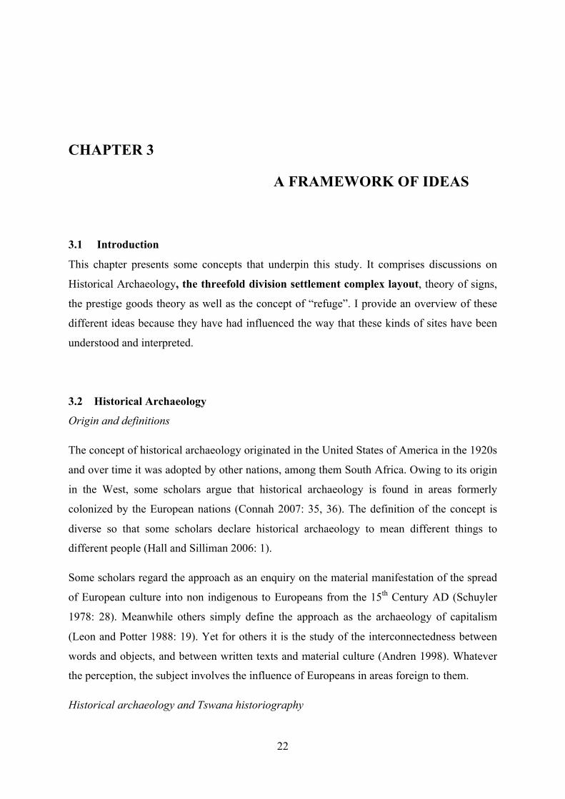
CHAPTER 3 A FRAMEWORK OF IDEAS ......................................................................... 223.1 Introduction ................................................................................................................. 223.2 Historical Archaeology ............................................................................................... 223.3 The threefold division ................................................................................................. 233.4 The Prestige Goods ..................................................................................................... 243.5 Theory of Signs ........................................................................................................... 25
CHAPTER 4 METHODOLOGY ........................................................................................... 274.1 Introduction ................................................................................................................. 274.2 Mapping the site .......................................................................................................... 274.3 Excavation ................................................................................................................... 30
CHAPTER 5 SPATIAL ANALYSIS .................................................................................... 36
v
5.1 Introduction ................................................................................................................. 365.2 Selonskraal south - Macro-settlement features ........................................................... 375.3 Comparison with Molokwane ..................................................................................... 425.4 Movement through the site ......................................................................................... 435.5 Anomalies ................................................................................................................... 475.6 Isolated hut floors ....................................................................................................... 51
CHAPTER 6 EXCAVATION DATA .................................................................................... 546.1 Introduction ................................................................................................................. 546.2 Stratigraphy ................................................................................................................. 546.3 Dating the occupation ................................................................................................. 576.4 Excavated material ......................................................................................................... 57
6.4.1 The multivariate analysis ........................................................................................ 64CHAPTER 7 DISCUSSION & CONCLUSION ................................................................... 70
7.1 Introduction .................................................................................................................... 707.2 Spatial data ..................................................................................................................... 70
7.2.1 The kgosing ............................................................................................................. 727.2.2 Micro-settlement spatial anomalies ........................................................................ 737.2.3 Macro settlement variations .................................................................................... 75
7.3 Faunal material ............................................................................................................... 767.4 Pottery and walling ........................................................................................................ 787.5 Population estimates ...................................................................................................... 797.6 Conclusion ..................................................................................................................... 79
REFERENCE LIST ................................................................................................................. 82

vi
LIST OF FIGURES Figure 1.1. Map showing location of Selonskraal South and study area..................................2
Figure 1.2. Selonskraal South& Molokwane: Hill shaded digital elevation model (DEM) 2x vertical exaggeration ECW format.............................................................................................3
Figure 2.1. Vessel profile after Biemond (2014).....................................................................13
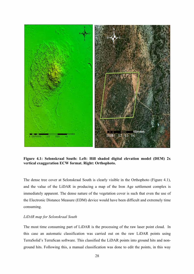
Figure 4.1. Selonskraal South: Left: Hill shaded digital elevation model (DEM) 2x vertical exaggeration ECW format. Right: Orthophoto........................................................................28
Figure 4.2. Hill shaded digital elevation model (DEM) 2x vertical exaggeration ECW showing location of the midden that was excavated.................................................................................................................................30
Figure 5.1. SEL 1, a commoner “settlement unit” at Molokwane...........................................37
Figure 5.2. Map showing cluster distribution across the site with the SS1 being largest.......38
Figure 5.3. Map showing lineage Unit SS1 in the central area of the site...............................40
Figure 5.4. Map showing position and distribution of features in SS2...................................42
Figure 5.5. Map showing major pathways at Selonskraal South leading to SS1....................45
Figure 5.6. Map showing position of sealed lintels at Selonskraal South.............................46
Figure 5.7. A sealed lintel in the north eastern anomalous kraal…………………….............47
Figure 5.8. Part of the hilltop rectilinear structure showing retouched stone blocks ……….48
Figure 5.9. Map showing distribution of rectilinear structures...............................................49
Figure 5.10. One of the rectilinear structures at the base of the hill to the east……………..49
Figure 5.11. Map showing position where European artifacts were recovered......................50
Figure 5.12. Map showing position of hut floors at the base of the hill................................. 51
Figure 5.13. A furrow like feature within one of the isolated huts..........................................52
Figure 5.14. Potsherds recovered in association with the isolated huts at the base of the southern hill............................................................................................................................................53
Figure 6.1. N1 stratigraphy southern wall profile....................................................................54
Figure 6.2. M1 west wall profile.............................................................................................55
Figure 6.3. N1 west wall profile..............................................................................................56
Figure 6.4. Graph representing fluctuations in bone occurrence in M1..................................58

vii
Figure 6.5. Graph representing fluctuations in bone occurrence in N1...................................58
Figure 6.6. Variety of taphonomic marks at Selonskraal South..............................................63
Figure 6.7. Vessel profiles from M1……………………………………………………..….65
Figure 6.8. Vessel profile from the surface findings...............................................................65
Figure 6.9. Vessel profiles from N1........................................................................................66
Figure 6.10. Ostrich eggshell beads from Selonskraal South.................................................67
Figure 6.11. Fully preserved cowrie shell from Selonskraal South........................................68
Figure 7.1. Lintel into the kraal that abuts the chief’s kgotla at Selonskraal South........................................................................................................................................71
Figure 7.2. Perforated proximal phalanx of a Redunca fulvorufula.........................................77

viii
LIST OF TABLES
Table 6.1. NISP counts for M1 and N1 ...................................................................................57
Table 6.2. M1 species list at Selonskraal South.......................................................................59
Table 6.3. N1 species list at Selonskraal South........................................................................59
Table 6.4. NISP and MNI at Selonskraal South.......................................................................60
Table 6.5. Elements that could not be identified to species………………………….………60
Table 6.6. Distribution of ostrich eggshell beads……………………………………………67

1
CHAPTER 1
INTRODUCTION TO STUDY
“The word Tswana refers today to a collection of differentiated but closely related Bantu-
speaking communities found in Botswana and South Africa” (Crossland 2013: 81).
1.1 Introduction
The farm Selonskraal situated 15 kilometres west of Rustenburg is characterized by stone
walled settlements built by African farmers from the 17th century onwards. One of the most
well-known of the sites in the Rustenburg area is Molokwane, which is said to have been
occupied by the Sotho Tswana speaking peoples of BaKwena Bamodimosana Bammatau
sometime after AD 1650 (Pistorius 1992) (Figure 1.1). According to Pistorius (1992: 3), the
site of Molokwane is “...distributed over a long, narrow area, east of the Selons or Ngwaritse
River, stretching over a distance of 3 km from north to south and an average distance of
1,5km from west to east.” Pistorius (1992: 17) asserts that the size of the site i.e. 4 to 5 square
kilometres, makes Molokwane one of the largest stone walled archaeological sites in South
Africa. In 2015, a LiDAR1 survey was carried out to capture the extent of the stone walled
site, and during the survey two outlying sites were exposed, one to the south and another to
the east of Molokwane (Figure 1.2). These sites which were obscured by tree cover had not
been recorded or excavated. This study will focus on the site to the south of Molokwane main
site. The site, called Selonskraal South for the purposes of this study lies less than two
kilometres to the south of Molokwane.
1 LiDAR- Light Detection and Ranging

2
Figure 1.1: Map showing location of Selonskraal South and study area.

3
Figure 1.2: Selonskraal South& Molokwane: Hill shaded digital elevation model (DEM)
2x vertical exaggeration ECW format.

4
1.2 Biophysical Context of the Study Area
Overview
It is important to understand the biophysical context of a given study area so as to have
insights on why the occupants chose the location. The site falls into the Late Iron Age period
where crop and livestock farming were a significant economic activity. This would have
required careful selection of the location to build settlements. Below is an outline of the
biophysical context of the site’s surrounding area and will be further discussed in Chapter 7.
1.2.1 Landscape and Vegetation Biome
Selonskraal South is located within a catchment formed by Selons River and its tributaries
(Figure 1.1&2). The hill on which the site was built is low and isolated. Other low hills can
be seen a few kilometres to the east, whereas the magnificent Magaliesburg range lies
prominently to the north and east. The landscape immediately around the Selonskraal South
has evidence of high velocity lateral erosion where massive soil sediments have been eroded
or imposed.
The study area falls within the Savanna Biome within the Moot Plains Bushveld (Svcb 8)
(Mucina and Rutherford 2006: 462-465). This vegetation is dominated by an open to closed
Acacia savanna and is characterised by low to medium sized hills. Depending on slope,
exposure and aspect, hill slopes can be fairly densely vegetated. Vegetation is typified by
Acacia robusta, A. caffra and A. erubescens, Burkea Africana, Combetum imberbe, Cussonia
paniculata, Dombeya rotundifolia, Spirostachys africana, Vangueria infausta. The low shrub
and grass layer is poorly developed, and the hill slopes have been invaded by aliens (Mucina
and Rutherford 2006).
1.2.2 Geology, Soils
The soils comprise shales, quartzites and andesites of the Pretoria Group (Transvaal
Supergroup). Mucina and Rutherford (2006: 446) note that the soils are predominantly red
and yellow. These soils are weakly developed by nature and have a low to moderate base
status.

5
1.2.3 Climate
The site falls within the summer rainfall area in which the winters are very dry but often with
frost in the low lying areas (Mucina and Rutherford 2006). The mean annual rainfall for the
region ranges between 550mm and 650mm (Mucina and Rutherford 2006: 462).
1.3 Research and aims
Selonskraal South was built according to the Central Cattle Pattern (Huffman 1982, 1986,
2007), but with some features less common to the region. The summit of the hill is marked by
a rectilinear structure, which is surrounded by typical Sotho Tswana curvilinear structures.
Moving down the hill, households have curved back walls with the remains of hut dwellings,
verandas, kitchens, grain bins, big and small kraals, some of which have lintels. Like
Molokwane the central kraals and associated court have a two-metre-high back wall. Several
other rectilinear structures with retouched stone blocks are located at the eastern foot of the
hill. This may suggest some form of European influence, the nature of which has yet to be
determined. This research approaches the composition of the site at both macro and micro
levels in order to understand the relationship with other stone walled sites in the Rustenburg
area.
Aim
To map and excavate Selonskraal South to determine how it fits into the immediate and
broader history of the region.
Objectives
• To establish whether there are single or multiple occupations
• To refine the LiDAR map of the site (by adding details of middens- entrances, exits to
kraals, gardens etc)
• To date the occupation/s of the site
1.4 Dissertation outline

6
Chapter One of the study introduces the research. It gives a background, aim and objectives
of the study. In addition, it gives an outline of the environmental of the research area.
Chapter Two focuses on a review of related literature. I will explore some literature on
various aspects Sotho Tswana history and archaeology. Chapter Three focuses on the
theoretical framework that underpins this study while, Chapter Four discusses and explain
the methodology used in this research as well as brief introduction to the excavation data.
Chapter Five pays close attention to the layout of the site by mapping out features on the
LiDAR. Chapter Six presents the excavation data and the material culture analyses. Chapter
Seven concludes the study with a comprehensive discussion and conclusion in which
recommendations for future studies are laid out.

7
CHAPTER 2
LITERATURE REVIEW
2.1 Introduction
The study area covers the Rustenburg, Pilanesburg and Zeerust area where there are many
stone walled sites attributed to various Late Farming Communities. Amongst these, the most
commonly researched sites include the megasites at Molokwane, Marothodi, Olifantspoort,
Boitsemagano and Kaditshwene which are all classified as Late Moloko sites (Post AD1650)
associated with the proto-Tswana and ‘Tswanaised Nguni’ groups (Pistorius 1992, 1994,
1997, 1999; Boeyens 2000, 2003; Hall et al 2006, 2008; Anderson 2009). This area is hilly or
mountainous with plenty of pastures and rivers, making it a suitable place for farming and
construction of towns. This chapter discusses the archaeology of the study area and oral
histories to give background and set the direction of research at Selonskraal South.
2.2 The archaeology of origins of the Tswana
The origin of Tswana speakers was debated in the 1980s by Mason and Evers. According to
Mason (1983), the Tswana originated at Broederstroom around AD300 in what is the “Oori
Tradition.” The Broederstroom site is thought to have been occupied until around AD600
when the ancestors of the Tswana moved away for a long period until around AD1300 when
they returned to the Magaliesburg in a “Middle Iron Age” setting and building settlements at
Olifantspoort (Mason 1981b, 1983, 1986). Mason argued that from the inception of
Broederstroom the ancestors of the Tswana were farmers and they continued with the
tradition when they went to Olifantspoort. Mason saw continuity in pottery styles and hut
floor layouts (Mason 1986). Mason hypothesised that the 500-year hiatus was caused by
adverse climatic conditions that caused people to abandon the area. Mason’s 500-year hiatus
may have been due to an incomplete exploration of the surrounding area. A site dating to
1090±50 BP was found at Kleinfontein 62JP near Kaditshwene suggesting that not all people
left the area, and that there may be more continuity than previously thought (Boeyens 2003:
65).

8
The Oori Tradition was contested by Evers (1983) who argued that the Tswana migrated into
South Africa around AD1300 in what is described as an intrusive group that overlaid an
already existing Iron Age Tradition (Eiland). Evers did not see any continuity between
Broederstroom and Lydenburg facies and concluded that they all fell under the Mzonjani
group of the Kalundu Tradition and not Moloko (Urewe Tradition) (Evers 1983).
The Oori Tradition has been challenged by several scholars since its proposition. It has been
argued that the hiatus between Broederstroom and Olifantspoort is too big to be explained by
the climate hypothesis (Evers 1983; Huffman 2007). In addition, it is also argued that there is
no continuity between Broederstroom and Olifantspoort because they do not fall in the same
sequence (Huffman 2007: 428). Icon is then regarded as the first phase of Moloko sequence
(Hanisch 1979) and Broederstroom falls under the Mzonjani facies of the Kalundu Tradition
(Whitelaw 1996; Huffman 2007). This research follows the Moloko sequence proposed by
Evers, and which has been accepted by various other scholars (Hall 1998; Huffman 2002,
2007; Boeyens 2003; Hall et al 2006, 2008; Rosenstein 2008; Anderson 2009).
However, the acceptance of Icon as the root of the Moloko sequence in South Africa has been
challenged. Biemond argued that sites in eastern Botswana and the North West Province of
South Africa represent the earliest phases of Icon (Biemond 2014: 25). These pots, as
Biemond argues, have several Eiland design elements that were later incorporated into early
Moloko ceramics like horizontal incised or punctated bands separated by red ochre and
graphite (Biemond 2014: 25).
From his research, Biemond legitimately argues that the origins of the Moloko sequence is
still a mystery. His arguments seem to suggest that the Moloko sequence began somewhere in
Botswana and the North West Province of South Africa and that Icon should be further
investigated (Biemond 2014: 25, 247).
2.3 Historical Layering
A study of ethnography, oral history and eye witness accounts suggest that the study area was
occupied by different groups at the same time (Hall 1998, 2012; Hall et al 2008). Tswana
groups are said to have migrated into southern Africa in a succession of waves (Stow 1905).
Oral history suggests that the Rolong were the principal group which migrated from “far
north” around AD1400 and on their arrival they settled near Mafeking i.e. south east of the
Crocodile and Marico Rivers (TNAD 1905: 8; McDonald 1940: 4; Schapera 1952: 6). This
site at the confluence of the Crocodile and Marico Rivers has been identified as Rathateng
9
(Pistorius 1995). This group was the third and largest wave of the Tswana. On their arrival,
they were under the leadership of the paramount Chief Morolong (McDonald 1940: 4).
The arrival of this group at Rathateng is said to have marked the beginning of irreconcilable
political or ideological differences whose ultimate results in the dispersal of the group
members (cf TNAD 1905: 8). There are some discrepancies as to what transpired. On one
hand, it is said that three major divisions were formed as a result of fission - Hurutshe,
Kwena and Kgatla (Schapera 1952). In contrast, others say that it was only the Hurutshe that
split from the principal group (TNAD 1905: 8). In addition, Legassick (1969b) includes the
Phokeng as a splinter group. It is clear therefore that oral histories are problematic and cannot
be taken at face value. Regardless of these discrepancies, there is a consensus among the oral
history accounts that the Tswana speaking people migrated into South Africa from elsewhere.
2.4 Major groups in the Rustenburg Zeerust region
Hurutshe group
The Hurutshe as discussed above, were part of the main group led by the Rolong (TNAD
1905: 8), while elsewhere they are believed to have been a part of the Kwena (Mpotokwane
1974: 37). It is believed that the Hurutshe moved from the north to the south under Chief
Phofhu and settled south of the Limpopo/ Oori River (Mpotokwane 1974: 37). This marks
some resemblances with oral histories provided by the TNAD (1905). The children of chief
Malope quarrelled over chieftainship so that Lehurutshe (woman) took away a large fraction
to Tsoenyane near Heidelberg and on their way they passed through the Magaliesberg, then
up to the Madiko (Marico) (Mpotokwane 1974: 37). These movements are in concordance
with Legassick’s reconstructions (Legassick 1969b: 100). According to Boeyens (2003: 63),
the Hurutshe moved to Tswenyane (Tsoenyane) around the 15th century AD. Whatever the
dates of their movements, the Hurutshe passed through the Magaliesberg.
Kwena Modimosana and Mogopa
After the fission from the main group, the Kwena cluster was composed of the Modimosana
and Mogopa subgroups and it is from these that the Manamela, Mmatau, Maake and Tlhaku
were derived (Breutz 1953: 427). While at this settlement, called Rathateng in the Marico,
this unified group was led by Chiefs 1 Mogopa Tsokelele Dimolema (Kwena chief) and
Motsele (leader of the Mogopa), who had a serious dispute about initiation. As a result, Chief

10
Motsele split from the group along with the Mogopa and went to Zandrivierspoort 747 in the
Rustenburg area where they subsequently moved to the Mabjanamatswaana Mountains and
eventually to Bethanie Mission station (Breutz 1953: 427). On the other hand, Chief V
Modimosana took the Kwena to the Magaliesburg and settled at Rhenosterfontein 398, where
his sons quarrelled about chieftainship so that the Kwena Modimosana were divided into
four; Mmanamela, Mmatau, Maake and Tlhaku (Breutz 1953: 428). Ultimately, the main
groups of the Modimosana i.e. the Mmanamela and Mmatau settled at Boitsemagano
(Mamogowe) and Molokwane, respectively (Breutz 1953; Pistorius 1992: 44). These two
related groups transformed into major centres of power in the Rustenburg area, with
Molokwane as the most powerful, more so under the reign of Chief Kgaswane (Breutz 1953).
Other groups
Other groups in the region include the Tlokwa, Fokeng, Po and the Tlhako who all share
Nguni descent (Hall et al 2008: 68; Hall: 2012). However, an oral history account of the
Tlokwa says the group was part of the Hurutshe, a Tswana group, although Breutz has
expressed some doubt (Breutz 1953: 22, 200; 1989: 377). Whatever the case, the Tlokwa
have been associated with the megasite at Marothodi. The ceramics at Marothodi is typified
by Buispoort and Uitkomst ceramics. The Uitkomst ceramics which were the majority of the
Marothodi pottery assemblage were locally made, while the Buispoort ceramics were
introduced (Hall et al 2006, 2008; Anderson 2009).
The Phokeng historically settled in the Rustenburg area and are believed to have been a part
of the southerly migration of the Hurutshe. They are said to have split from the Hurutshe
under chief Kwena (Breutz 1953: 57). However, Breutz questioned these claims because he
believed the Fokeng was an older group that predated the Hurutshe (Breutz 1953: 20). In the
18th century the Fokeng settled at Boschpoort and subsequently left and settled near what is
now Fokeng. During the Difaqane they moved to Thaba Nchu and other places in the Free
State but returned to their former home when Mzilikazi was defeated by the Boers (Breutz
1953: 56).
The Po, Tlhako and the Kgatla who had an Nguni origin (Hall et al 2008: 68), also played a
part in complicating layers of occupation in the study area. The Po dispersed from their
secondary point of dispersal in Pretoria and established a settlement between Sterkstroom
River in the west and the Crocodile River in the east in the mid-17th century while other

11
settlements were built in the late 18th and early 19th centuries (Hall et al 2008: 68). Similarly,
the Tlhako also dispersed to other areas from Pretoria. Among other places, they established
settlements at Mabies Kraal and Pilwe Hill in the 17th century (Breutz 1953: 176, 288). It is
important to note that, Pilwe Hill is also associated with the Mmatau (Kwena lineage from
Molokwane) after their return from the Free State after 1840 (Breutz 1953). In addition, Hall
et al (2008: 68) also associate the Pilwe Hill with the Tlokwa.
While oral histories give important insights from around the 18th and 19th Century about
communities and their alliances (e.g. Breutz 1953), they may not have any direct bearing on
the earlier periods. However, oral history record provides useful information about the
occupation of communities at the megasites of Kaditshwene, Marothodi and Molokwane
(Seddon 1966; Pistorius 1992; Boeyens 2000, 2003, Hall et al 2006, 2008; Anderson 2009),
and the oral record alerts researchers to the historical layering and fluidity of communities
and the importance of this for archaeological studies (Hall 2012).
2.5 Material Culture studies
Terminology
When studying ceramics, it is important to fully appreciate the associated terminology.
Terminology is a methodological bridge between theory and data (Huffman 1980: 168). The
following terminologies are used in Southern African pottery studies; tradition, branch,
facies, phase and cluster.
Tradition
Classification of ceramics is important for analysis (Miller 1991: 12). In a broader sense, a
tradition is defined as the time depth of a decoration theme (Huffman 1974a). A tradition is
also defined as a style made up of every possible modal combination in an assemblage
(Huffman 1980: 168). In addition, a tradition has also been defined as a collection of related
ceramic units (Huffman 2007: 117). Thus, in general, all ceramic units form part of a broader
unit called a tradition (Huffman 2002: 6, 2007: 117). Nguni and Sotho Tswana pottery have
therefore been placed into the “Urewe Tradition” which entails that these communities
migrated from East Africa (Huffman 2007). However, this term, which is often juxtaposed
with “Culture”, to refer to places where an assemblage is first found, can be problematic
12
because they give an impression that such sites are the original points of the original
manufacture and distribution of ceramics (Pikirayi 1991: 187).
Phase
Mobility is an integral component of southern African archaeology (Fredriksen et al 2016).
Mobility and other causes caused communities to split and it was through these that ceramic
assemblages were retouched and produced minor differences. For instance, the Icon people
are thought to have split to form Letsibogo, Olifantspoort and Madikwe. These new
assemblages have been defined as Ceramic phases because they are time phases of a tradition
(Huffman 2002: 6, 2007: 118). Icon itself is the first phase of the Moloko branch of the
Urewe Tradition.
Ceramic Branch/ Cluster
The largest component of a tradition is a Branch/ Cluster. According to Huffman (2002;
2007), a combination of related facies forms a cluster/branch. The term Moloko proposed by
Evers (1983) was defined as a Branch/ cluster by Huffman (2002; 2007). In other words a
Branch/ Cluster is “…one of the multiple sequences within a Tradition (Huffman 2007: 117).
Facies
Facies are ceramic units (Huffman 2002: 6; 2007: 117). Clarke et al (1966: 117) defined
Facies as variations in ceramics that are derived from one stratigraphic body. In the case of
the Sotho Tswana, Huffman (2002: 7; 2007: 118) demonstrated that “Letsibogo”,
“Olifantspoort” and “Madikwe” are Facies. It has been noted that names of facies can also be
given to communities who made them. For example the Msuluzi community produced the
“Msuluzi style” (Huffman 2007: 117). In the case of the Western Sotho Tswana in would
mean they produced the “Icon style” (Huffman 2002: 7).
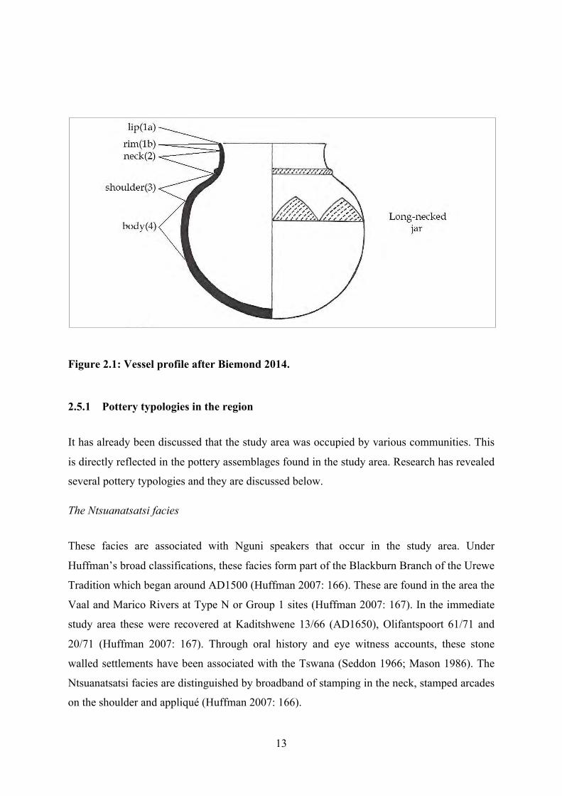
Vessel morphology
A pot has different parts which have all been named for purposes of identification and
analysis. An important attribute for ceramic classification is the profile of a pot (Figure 2.1).
13
Figure 2.1: Vessel profile after Biemond 2014.
2.5.1 Pottery typologies in the region
It has already been discussed that the study area was occupied by various communities. This
is directly reflected in the pottery assemblages found in the study area. Research has revealed
several pottery typologies and they are discussed below.
The Ntsuanatsatsi facies
These facies are associated with Nguni speakers that occur in the study area. Under
Huffman’s broad classifications, these facies form part of the Blackburn Branch of the Urewe
Tradition which began around AD1500 (Huffman 2007: 166). These are found in the area the
Vaal and Marico Rivers at Type N or Group 1 sites (Huffman 2007: 167). In the immediate
study area these were recovered at Kaditshwene 13/66 (AD1650), Olifantspoort 61/71 and
20/71 (Huffman 2007: 167). Through oral history and eye witness accounts, these stone
walled settlements have been associated with the Tswana (Seddon 1966; Mason 1986). The
Ntsuanatsatsi facies are distinguished by broadband of stamping in the neck, stamped arcades
on the shoulder and appliqué (Huffman 2007: 166).

14
The Uitkomst facies
The Ntsuanatsatsi facies developed into the Uitkomst facies (Nguni) found near the Vaal,
Potchefstroom, Johannesburg, Pretoria up to the Marico, Crocodile River and Waterberg area
(Huffman 2007: 171). The Uitkomst facies are distinguished by stamped arcades, appliqué,
parallel incisions and stamping. They are associated with Klipriviersberg/ Group III walling
(Huffman 2007: 173). Uitkomst are a result of the mixture of Ntsuanatsatsi and Olifantspoort
(Huffman 2007: 173).
Olifantspoort facies
The Olifantspoort facies which are characterized by multiple bands of fine stamping or
narrow incisions separated by colour are found at Broederstroom 3/84, Ifafi 35/ 85,
Olifantspoort 29/72 and Robert farms 28/71, 27/71 and 64/71 (Huffman 2007: 191).
According to Huffman, these date between AD1500 and 1700.
Madikwe facies
The Madikwe facies were derived from Icon (Icon is the first facies of the Sotho Tswana
when they arrived in South Africa) and are distributed in the North West Province at the
Marico and Crocodile Rivers as well as Waterberg areas while across the border, they are
also found in Botswana (Huffman 2007: 199, 431). These facies are distinguished by multiple
bands of cord impressions, fingernail impressions, incisions, stabs and punctates set apart by
colour (Huffman 2002: 12, 2007: 201, 431; Boeyens 2003: 65).
Buispoort facies
These are regarded as the last facies of Icon before colonisation by the Europeans. The
Buispoort facies developed from Madikwe and are associated with Western Sotho Tswana
speakers of the Kwena and Hurutshe lineages. As such, they are associated with Molokwane
type walling (Huffman 2007: 433) and were recovered at the sites of Molokwane,
Kaditshwene and Olifantspoort. The pots are characterised by rim notching, broadly incised

15
chevrons and white bands and red ochre. This facies is believed to date between AD1700 and
1840 (Huffman 2007: 203, 433). The clay is mixed with a micaceous temper (Rosenstein
2002, 2008). In terms of variety, there is a general lack of bowls which are predominant in
the earlier facies of the same sequence (Hall 1998).
As discussed above, research has associated ceramics, walling and identity. Ceramic designs
are thought to be markers of group identity because they are thought to be repeated codes of
cultural symbols, while stone walling has been classified according to region and associated
pottery (Huffman 1982, 1986, 2002, 2007). It has been shown however that this broad brush
stroke approach can mask historical dynamics like the historical layering, acculturation,
intermarriages and assimilation (Loubser 1991; Esterhuysen 2008).
2.6 Stone walling typologies
The post AD1700 period in Tswana history was characterised by increases in stone walling
(Hall 1998; Boeyens 2003). Settlements were built on hill sides and spurs in direct contrast
with the early Moloko period when settlements were located on the plains in the Marico area
(Boeyens (2003: 63). Researchers have classified stone walling into several categories based
on location, identity, or changing power dynamics (Hall 1998). This stone walling of the
Tswana regardless of location were built according to the Central Cattle Pattern (CCP)
(Huffman 1982, 1986, 2007). Below I discuss various typologies that have been associated
with the Tswana according to Maggs (1976), Mason (1986), Taylor (1979) and Huffman
(2007).
2.6.1 Maggs’ Classification
According to Maggs (1976), stone walling can be categorised into four distinct classes based
on spatial layout; Type N, R, V and Z. In this research I will discuss the first three types only.
Type V
These are composed of several primary enclosures that are arranged in ring formation. These
primary enclosures are either adjacent to each other or they are connected by a secondary
wall. This arrangement produces a secondary enclosure in the middle (Maggs 1976: 28). In
some sites there are free standing structures which are mostly in the form of huts mostly
situated on the edges of the settlement unit. The primary enclosures are thought to be
16
livestock pens (Maggs 1976: 28). These sites are found in the north eastern parts of the Free
State Province as well as in the south eastern parts of Gauteng (Maggs 1976: 28).
Type N
This type is composed of primary enclosures organised in a ring shape which forms a
secondary space in the middle. They are distributed in the north eastern Free State and areas
bordering the Gauteng Province.
Type Z
The central zone in this category is composed of between three and eight kraals that nearly
touch and sometimes with smaller kraals that may have been huts of herd boys. The entrances
to these kraals face the secondary space formed by the often present secondary walling. Such
walling has been found in areas close to Platberg. The central kraal complexes are enclosed
within an outer circle of discontinuous bilobial dwellings (Maggs 1976: 40, 41).
2.6.2 Taylor’s Classification
Group 1
Taylor describes “Group 1” settlements as having outer elliptical walls with small central
kraals (Taylor 1979: 10) (Figure 2.2). These sites have freestanding circles in open spaces
lying between the central kraals and the oval outer wall (Taylor 1979: 13). The walling is
generally thirty centimeters in height although there is rubble all over to suggest that the
walling may have been higher (Taylor 1979: 13).
Group 2
Walling in this category is composed of outer scalloped discontinuous walls with dwellings
facing inwards (Figure 2.2). In the central area there lies a series of small kraals that were for
17
livestock. The space dividing the central kraals and the outer walls is mostly empty but
oftentimes with stone heaps and ash middens (Taylor 1979).
Group 3
These sites are composed of “…an agglomeration of circular enclosures with the outer limit
marked by varying lengths of curved walls and circular enclosures” (Taylor (1979: 10)
(Figure 2.2).
2.6.3 Mason’s Classification
Revil Mason performed his first classification in 1952 but revised in 1986. In this research I
present the classes in the 1986 classification.
Class 1
There is an isolated kraal/ enclosure with an uneven, imperfectly round or elliptical boundary
(Mason 1986: 335). No remains of huts or embayments of any kind can be found in class one
walling. It is believed that these sites were or may have been the earliest form of stone
walling or the builders were a poverty ridden people (Mason 1986: 335). The walling is
generally low and Mason was uncertain if this was partly due to robbing of the walls. At the
time of publishing of his research, the dates of these sites were unknown but sites of this type
were found in the eastern part of Johannesburg.
Class 2
These sites are extensive and have a boundary wall which results from the adjacent crudely
round kraals that are set apart by open stretches of curved walls. There are fairly extensive
open spaces in most sites that have small kraals within them (Mason 1986: 336). Generally
speaking, the builders of Class 2 sites did not demarcate private areas and it is suggested that
this may have been due to poverty. These sites are specific to the following parts of
Northcliff and Klipriviersberg whereas they also occur at Matlwase in the western Highveld
(Mason 1986: 336). Mason likens this type to Taylor’s (1979) Group 1 sites.
Class 3
Class three walling was found at the Boons area located south of Olifantspoort in the
Grassveld- Bankenveld ecological region (Mason 1986: 336). These sites are thought to have

18
been cattle posts for class 6 settlements (to be discussed) sites at Olifantspoort 20/71 further
north in the Magaliesburg. They comprise a large oval/ elliptical inner space that is
surrounded by a boundary wall that is produced by placing small circular stone walls edge to
edge (Mason 1986: 336).
Class 4
Sites in this class have been found in the Magaliesburg Valley. Mason discovered that such
sites also occur at Olifantspoort 20/71) and it appears that these sites are situated adjacent to
Class 6 sites (to be described) (Mason 1986: 337). Class 4 sites are described as having
crudely round or elliptical boundary walls. The elliptical walls lie side by side to inner zone
of smaller roughly circular structures. Each of these structures lie associated with an
embayment/ scallop and broadly speaking, this site typology seems to be related to Maggs’
Type V sites that occur in the Free State Province (Mason 1986: 337).
Class 5
In terms of morphology, Class 5 sites have an oval boundary wall with short sections of
walling projecting at right angles on the inner side of the boundary wall. This typology was
found at Klipriviersberg 5/65 except in this area there are demarcations for the private areas
where remains of huts were seen (Mason 1986: 337). Smaller kraals are enclosed within the
outer boundary walls described earlier (Mason 1986: 337).
Class six
Sites in this class form megasites of the Oori Tradition of the Sotho Tswana speakers (Mason
1986: 339). These sites date after around AD1500 and they are thought to have been built by
the Hurutshe and Kwena communities. They comprise a boundary wall (the boundary wall is
continuous) with scallops/ embayments and each of these enclose a hut. The megasites falling
in this category occur at Olifantspoort 20/71 and the walling went to as high as two metres.
This highest walling has been associated with the highest point of the site thought to be the
royal area (Mason 1986: 339).
19
Class 7
Class 7 sites are composed of an outer boundary wall which is made up of isolated scallops
and each scallop is set apart from the neighbour by an open gateway. These sites were found
at Platberg, Olifantspoort 20/71 and it appears that they are related to Maggs’ (1976) bilobial
settlements in the Free State Province (Mason 1986: 340).
Class 8
These are limited only to the eastern parts of Potchefstroom in the North West Province at
Leeuwkop (Mason 1986: 340). Sites in this class have smooth oval boundary wall that
encloses inner parts uniformly placed circular enclosures (Mason 1986: 340).
Class 9
Along with class 6 sites, sites in this category form part of the megasites of the stone walling
in the Oori Tradition. They have extensive sprawling areas but with no single boundary wall
(Mason 1986: 340). They have single wall units made up of five to ten scallops that stretch to
the end and in each of these there are huts. Opposite to these huts are extensive circular
kraals. Sites of this class were found at Kaditshwene 13/66, Sun City 30/81 (Marothodi) as
well as at Kamakwe 44-46/76). They are adapted to larger populations which is also
characteristic of Class six sites (Mason 1986: 341).
Class 10
These are limited only to a site at Olifantspoort 2/72. The walls were built using stone
pebbles in circular arrangement as hut foundations or as pathways. Radio Carbon dates for
this site is very recent (not specified) and details about the layout are not explicit.
Class 11
This class is located in caves alone and Mason (1986: 343) hypothesizes that building
settlements in caves may have been for refuge purposes. Such sites occur at Melville Koppies
Cave and at Uitkomst Cave in the Magaliesburg near Olifantspoort (Mason 1986: 343).

20
2.6.4 Huffman’s Classification
Huffman used the variabilities expressed in settlement styles established by Maggs and
Taylor to make historical arguments about sequence and interaction. The walling styles were
all classified as Central Cattle Pattern walling. In his supporting arguments, Huffman notes
that the Ntsuanatsatsi cluster (Maggs’ Type N) is the cradle of all walling associated with
Nguni and Sotho Tswana communities (Huffman 2007: 33). All the walling according to
Huffman has cattle kraals located at the centre of all the walling while there is a tendency to
separate commoner and chiefs homesteads. In general, the walling is said to have been in the
formative stages between the 15th and 16th centuries in the Free State Province. During this
period, the Type N sites spread to areas across the Vaal into the hilly areas of Gauteng where
Mason (1968) and Taylor (1979) calls them Class 1 and Group 1 respectively. In all these
areas, Huffman classifies them all as Type N sites (Huffman 2007: 33).
Huffman (2007) observed similarities across all the typologies described above. Regardless
of the differences in classification, there is consistency in the mindsets to all walling. In a
way, the classification of walling into these multiple typologies may have been influenced by
limited access to aerial photography, and the lack of clarity offered by the photographs
(Maggs 1976: 37, 40). This research benefits from LiDAR, which explicitly extracts data
pertaining to the walls from the surrounding vegetation (Chapter Four). Some of these
classifications ignore transitional phases in the shift to more use of stone to demarcate social
boundaries. This argument was put forward by Mason who tentatively argued that the low
stone walling may have been in the formative stages of the walling tradition (Mason 1986:
335). Hall (1998) expands the idea by dividing walling into phases. During early to mid-17th
century low stone walling was used to demarcate space, while in the later phase (early 18th
century) the idea had been fully realised (Hall 1998: 242).
2.7 Tswana architecture
Architecture forms part of every society because it constitutes shelter. The most important
characteristic of architecture is shape. Before the arrival of Europeans, Southern African
architecture followed a circular plan (Mallows 1963: 11; Maggs 1976: 24). The local
communities lacked words for “straight” (Rapoport 1969: 77). However, Rapoport was not a
linguist and may have missed out on the local terminology of straightness. Precolonial Nguni/
Sotho Tswana architecture occurs in the form of bilobial, corbelled/ beehive or conical
dwellings which are all circular in nature.

21
The presence of rectilinear structures has been associated with European influence. Christian
missionaries sought to transform the African way of life and often involved trying to
influence the style of architecture (Crossland 2013: 79). These efforts were met with
resistance by the Tswana (Reid et al 1997; Crossland 2013: 80), until only after AD1860 with
the high growth in migrant labour (Frescura 2015). For example, at Molepolole the Chief
would not allow Europeans to build their structures in order to assert absolute control (Reid et
al 1997), however there are instances where chiefs built square structures for themselves
either to express their own power over the foreign or to signal their alliance with
missionaries.
2.8 Conclusion
From the literature it can be observed that there are many classification schemes which
purport to link material culture with cultural identity. This is seen in the way in which
identity is strictly linked to pots and stone walling. These linkages are problematic because
they fix people to material culture and yet oral histories of this period are replete with stories
of frequent interaction of communities. It is therefore not entirely possible to link material
culture with identities. Terminology is useful in the classification of ceramics but it masks
significant historical facts and dynamics. Some Historical Archaeologies have recognised
these historical dynamics (e.g. Loubser 1991; Hall et al 2008; Esterhuysen 2008; Boeyens
and Hall 2009). Similarly, the classification of walling into “Types”, “Groups” and “Classes”,
whilst important as a reference tool, also obscures the same historical details discussed above.
It is for this reason that Gosselain (2000: 188) looks at identity as a “process rather than an
entity.” From this background, it is imprudent to classify materials into Traditions,
Complexes or Classes and types.
22
CHAPTER 3
A FRAMEWORK OF IDEAS
3.1 Introduction
This chapter presents some concepts that underpin this study. It comprises discussions on
Historical Archaeology, the threefold division settlement complex layout, theory of signs,
the prestige goods theory as well as the concept of “refuge”. I provide an overview of these
different ideas because they have had influenced the way that these kinds of sites have been
understood and interpreted.
3.2 Historical Archaeology
Origin and definitions
The concept of historical archaeology originated in the United States of America in the 1920s
and over time it was adopted by other nations, among them South Africa. Owing to its origin
in the West, some scholars argue that historical archaeology is found in areas formerly
colonized by the European nations (Connah 2007: 35, 36). The definition of the concept is
diverse so that some scholars declare historical archaeology to mean different things to
different people (Hall and Silliman 2006: 1).
Some scholars regard the approach as an enquiry on the material manifestation of the spread
of European culture into non indigenous to Europeans from the 15th Century AD (Schuyler
1978: 28). Meanwhile others simply define the approach as the archaeology of capitalism
(Leon and Potter 1988: 19). Yet for others it is the study of the interconnectedness between
words and objects, and between written texts and material culture (Andren 1998). Whatever
the perception, the subject involves the influence of Europeans in areas foreign to them.
Historical archaeology and Tswana historiography
23
The history of Tswana speakers in South Africa in the last 500 years is widely documented.
This was achieved through the transcription of oral materials and ethnographic observations,
mostly by Europeans (see Schapera 1935, 1953; McDonald 1940; Breutz 1953; Kuper 1982).
The recording of African history by Europeans presents an array of problems, but the texts
can still be used. Although the texts lack depth and consistency, they emphasize on key
historical facets like mobility, cultural alliances, location of settlements and interpolity wars
that can be used to study the past.
Historical archaeology looks at the recent past following six main themes and these are;
scale, agency, materiality, meaning, identity and representation (Hall and Silliman 2006: 8).
The application of historical archaeology in South Africa has seen researchers successfully
ascribe specific stone walled sites to specific ethnic identities (see Pistorius 1992; Boeyens
2000). Meanwhile other researchers built on oral texts to study cultural alliances between
specific identities so that specific material culture can be ascribed to specific peoples (see
Loubser 1991; Esterhuysen 2008, 2009, 2012). Furthermore, with some in-depth analysis of
written texts, some scholars have managed to ascribe specific sections of Tswana sites to
specific historical figures2 (Boeyens 2016).
3.3 The threefold division
Tswana sites are divided into an ideological tripartite division. These divisions are central (fa
gare), upper (ntlha ya godimo) and lower areas (ntlha ya tlase) (Schapera 1953: 47).
Archaeologically, these divisions have been observed at megasites of Molokwane, Marothodi
and Kaditshwene (Pistorius 1992, 1996; Boeyens 2000; Anderson 2009). However, the
tripartite model has also been found at smaller sites e.g. Lebenya in the Swartruggens
(Jordaan 2016). This model assumes that the elites lived at the central area of settlements
(ntlha ya godimo), which was mostly the most the elevated part of the settlement. The
commoners are said to have inhabited the flanking lower areas (Schapera 1953; Boeyens
2003: 71). This is exemplified by the position of settlement unit SEL 2, the kgosing at
Molokwane which was located in the central area at the most elevated part of the settlement
(Pistorius 1992).
2 Through the use of Campbell’s (1822) travelogue, Boeyens (2016) was able to ascribe a “district” at Kaditshwene to Senosi, a highly placed political figure during the reign of the Regent chief “Diutlwileng” at Kaditshwene.

24
On a closer look, the tripartite model has multiple meanings. On one hand, it refers to three
physical divisions of homestead clusters. In other instances, it is a concept of social
stratification. However, the application of the model at the megasites needs to be
interrogated. For instance, there has been no research to find out if all the divisions at
Marothodi were occupied contemporaneously so that it constitutes an ideological tripartite
division (Anderson 2009: 94). Similarly, at Molokwane, dating was only done in Units SEL 1
and SEL 2 at Molokwane (Pistorius 1997: 126), while at Lebenya no dating was done at all
(Jordaan 2016).
It is also possible that Selonskraal South is one part in a much larger tripartite division. I thus
try to determine whether the south site was occupied at the same time as Molokwane and
whether its status relative to Molokwane can be determined through material culture.
3.4 The Prestige Goods
Definition
The Prestige Goods concept has its origin in the West (Friedman and Rowland 1977). It
entails that goods of high value such as gemstones, precious minerals, exotic glass imports,
metal jewelry were a preserve for the elites so that such goods were regarded as prestigious
(Moffet and Chirikure 2016: 4). The concept was later associated with the emergence of
social stratification whereby the rulers/ elites controlled the access to long distance trade
where such goods came from (e.g. Schortman & Urban 2004; Moffet and Chirikure 2016).
This implies that where they are found at archaeological sites, they are a reflection the
presence of elites as well as long distance trade. However, other scholars also regard special
goods manufactured locally to be prestige goods (Smith 1999 in Moffet and Chirikure 2016:
7).
Application in Southern Africa
The concept of prestige goods was applied to sites in Southern Africa where rulers are
thought to have controlled the trade and access to goods exotic to Africa such as glass beads,
cowrie shells, and cloth from the Indian Ocean Trade Network. Such a monopoly by the
rulers is argued to have led to social stratification in southern Africa (see Calabresse 2000;
Moffet and Chirikure 2016). Research in the Rustenburg area has been permeated by these
assumptions and architecture, and social structure have been analyzed through this lens (e.g.
Mason 1986; Pistorius 1992; Boeyens 2003; Boeyens and Plug 2011). Written sources are

25
often drawn on because they seem to corroborate this idea, for example, Campbell (1822:
249-250) states:
“He (the regent Chief) then complained that some of our attendants had
already exchanged beads with his people, which was contrary to their law; that all
strangers ought first to lay their beads before him as the ruler of the people, and if he
could not please them with articles in return, then they were at liberty to go to other
persons”
Critique of the concept
The notion of prestige goods has been altered by some scholars in southern Africa (e.g.
Moffet and Chirikure 2016). It has been argued that goods from long distance trade are not
always prestige goods, and that elites at inland societies did not necessarily control the trade
in exotic goods. Cattle, woman, children and metalwork were regarded as a source of prestige
(Moffet and Chirikure 2016). In my view, it was probably a mix of both.
3.5 Theory of Signs
The theory of signs in archaeology entails attaching meanings to specific material culture that
goes beyond the function of the object. The theory is applied to both material culture and
architecture which are regarded as materialisation of human ideology or worldview (Robb
1998). These symbols are thought to be devices that serve the purpose of communication
(Wobst 1977).
In South Africa the philosophy that material culture is encoded with cultural information is
widespread (see Fredriksen 2007, 2012; Esterhuysen 2008, 2012). This theoretical approach
has been taken by scholars of different generations; the older focusing more on culture
history units (Huffman 2002, 2007, 2012) and the later (cf Fredriksen 2007, 2012;
Esterhuysen 2008, 2012), insisting on context specific meanings of archaeological symbols.
Symbols, architecture and elevation
In archaeological circles various forms of architecture have been associated with status. For
example it has been argued that low crude walling represents less affluent people in the past
(Maggs 1976; Mason 1986). On the other hand higher and neater walling is associated with
the elites (Mason 1986). Higher walling is also thought to be reflective of the intention to

26
seclude certain parts of the settlement (Pistorius 1992). According to Posselt (1935: 142) in
Huffman (2007), elevation is symbolic of political power and prestige.
Tswana architecture is circular in shape and scholars have posited that the presence of
rectilinear structures at Tswana sites symbolises European influence. This influence can be
direct or indirect; ideas that are copied on one hand, with deliberate attempts by missionaries
to change the spatial world of African people (Crosland 2013: 80), on the other.
Other interpretation of the archaeological built environment has associated space with gender
(Alverson 1978; A. Kuper 1982; Huffman 1989, 2007). For example, according to the
Central Cattle Pattern (CCP) the malapa was meant for women and children whereas the
cattle kraals and main kgotla were areas for men.
3.6 Refuge and site location
The Late Farming Period (LFP) of the Sotho Tswana speakers in South Africa was marked
by significant transformations in settlement layout and location. There was a shift in
preference from low lying areas to high lying areas for purposes of refuge in the Marico
region (Boeyens 2003). Written sources are available in the form of missionary travelogues.
For instance, the 19th century capital of the Hurutshe booMenwe at Kaditshwene was built on
the summit of a mountain for purposes of refuge (Campbell 1822). The adoption of these
ideas in the analysis of archaeological settlements in South Africa is based on the idea that
the late farming period was a time of tension and war. However this concept of refuge does
not hold true for all sites in the region. Although some megasites were built on high lying
areas, some of these landscapes do not look as though they offer any defensive advantage.
Molokwane and Marothodi were built on slightly elevated landscapes that may suggest a time
of considerable economic prosperity and peace (Pistorius 1992; Anderson 2009; Hall 2012:
316).
In conclusion these ideas will help to frame the analysis of this project. These existing
observations about space, material culture and the associated society will be drawn on to
inform this study.

27
CHAPTER 4
METHODOLOGY
4.1 Introduction
The chapter is divided into two main sections; (a) mapping and (b) excavation. The first
section presents the method used to map the walls with LiDAR, and subsequent efforts to
verify the map. The second half explains the reasoning and techniques used to excavate a
midden, and analyse the material recovered from the excavation
4.2 Mapping the site
LiDAR
The site, Selonskraal South, was mapped for the first time with LiDAR in 2015. LiDAR
stands for Light Detection and Ranging (Michael et al 2002; Chase et al 2017: 89), and it is a
remote sensing method. LiDAR technology maps terrain through use of lasers as topographic
scanners and is particularly effective for mapping archaeological sites when there is a lot of
vegetation cover (Sadr 2016).
The mapping of the Selonskraal South site through LiDAR was done by the Southern
Mapping Geospatial (SMG). The survey was flown at a height of approximately 700m and an
Ortho-image with a 7cm pixel resolution produced. An aircraft mounted LiDAR system
scanned the ground below at a 150 kHz laser frequency rate. SMG produced both a digital
terrain model and a colour Orthophoto of the area (Figure 4.1).
28
Figure 4.1: Selonskraal South: Left: Hill shaded digital elevation model (DEM) 2x vertical exaggeration ECW format. Right: Orthophoto.
The dense tree cover at Selonskraal South is clearly visible in the Orthophoto (Figure 4.1),
and the value of the LiDAR in producing a map of the Iron Age settlement complex is
immediately apparent. The dense nature of the vegetation cover is such that even the use of
the Electronic Distance Measure (EDM) device would have been difficult and extremely time
consuming.
LiDAR map for Selonskraal South
The most time consuming part of LiDAR is the processing of the raw laser point cloud. In
this case an automatic classification was carried out on the raw LiDAR points using
TerraSolid’s TerraScan software. This classified the LiDAR points into ground hits and non-
ground hits. Following this, a manual classification was done to edit the points, in this way

29
some of the smaller and more subtle changes in topography were overlooked or dismissed. In
order to refine this data further, features like entrances, monoliths, grain bin bases, threshing
floors, grindstones and other smaller items were identified on the ground. The position of
each feature was recorded using a Garmin Handheld GPS device during a pedestrian survey.
Pedestrian Surveys
Foot surveys at the site were conducted over a period of four days. These surveys were
conducted to ground truth the LiDAR as well as to map in features with the Garmin Handheld
GPS device. Navigation throughout the mapping exercise was carefully planned so as to
avoid duplication of work, and to assist in achieving this all the mapped features were marked
with chalk. Mapping began in the south and proceeded in westward direction, then north and
eventually east. All the fieldwork activities were recorded in a field notebook. During these
foot surveys, photographs of various features were taken and a drop-box was created to store
and back up data.
Map overlay
GPX points taken in the process of mapping the site were exported from the Garmin
Handheld GPS device and imported into ArcMap 10.5: GIS software used to create maps. In
order to create maps for the site, the data were sorted out in the following method:
o Renamed points in the ArcMap attributes table for purposes of easy feature
identification on the final map
o Removed points that were not of significance to the aim of the study
o Grouping attributes/points in accordance with the map to be created. For example;
when mapping the movement of cattle only entrances and kraals were grouped
together
o Converting the newly grouped points into a shape file so that they could be overlaid
with the “ecw” LiDAR file to produce an overlay map

30
o Ecw LiDAR image displays as “unknown units” in ArcMap 10.5 so that the LiDAR
would fail to overlay with the GPX files. Thus the LiDAR had to be georeferenced.
To achieve this, I changed the Projected Coordinate System- (Central Meridian) to
“27” so that the projection changed to “meters”. It was then possible to overlay the
LiDAR with the GPX points and maps were created. The GPX points overlaid
perfectly with the LiDAR and apart from a few areas that were extremely heavily
treed the LiDAR was accurate.
4.3 Excavation
Excavation was done in order to obtain material culture. During the pedestrian surveys
discussed above we scouted for large cultural deposits such as ash middens. The
identification of the cultural deposit areas was guided by ethnography and existing
information from Tswana archaeological research in the Rustenburg area. Nevertheless, the
identification of middens was challenging because of the abundance of plant invasive species
throughout the site. One large midden was discovered at the summit of the settlement and the
location was mapped (Figure 4.2).
Figure 4.2: Hill shaded digital elevation model (DEM) 2x vertical exaggeration ECW showing location of the midden that was excavated.

31
Testing the ground
In order to assess the richness of the deposit, and locate the best place to excavate it was
decided to auger different parts of the midden before excavating. Six holes were augured but
only four produced cultural material. The deepest auger hole was 104cm deep. A regular soil
auger was used to test the deposit. The deposit was augered in 20cm increments, and was
sieved and sorted, and the nature of the soil recorded. All the data were recorded in a field
notebook and copies were made for back up. The augered materials included; pottery sherds,
one iron piece, bone, charcoal, ostrich eggshell bead fragments and marine shell fragments.
The excavated material was bagged and labelled on site and was then taken to the laboratory
at Wits University for further analysis.
Excavation method
The first step taken before excavating was to carefully clear the ground with a spade to
remove the plant species in the midden area. This was done to avoid contamination of the
material culture recovered from the trenches during excavation. We then set up a one metre
by two metres grid in a west to east orientation following the gradient of the midden. The grid
was then divided into two one metre by one metre squares so that each of the two members of
the team had a portion to excavate. The two squares were designated M1 and N1 for purposes
identification, and classification of material culture. Each square was further divided in half
because we were interested in reaching the base of the midden and exposing the stratigraphy,
in the time available.
We excavated in spits to maximise vertical control. The first spit for both trenches was 10cm
deep so as to remove the top soil layer. The first spit for trench M1 went over the intended
10cm because of the softness of the soil. However, all the subsequent spits were 5cm deep as
originally planned. Excavation was done until the cultural deposit petered out. Trench M1
went to a depth of 1.03m, and Trench N1 was excavated to the depth of 0.80m. Throughout
the course of excavation soil colour changes, texture and volumes were recorded. The
average volume per spit was three buckets, and the soil was sieved through a 0.5mm mesh so
that small cultural material, like beads, would not be lost. Bagging and labelling of material

32
culture was done on site. The material recovered included; animal teeth and bones, pottery,
ostrich eggshell beads, shells (cowrie), charcoal and bones.
4.4 Analysis of excavated material
The excavated material was taken to the laboratory at Wits University for more analysis.
Ceramics
The preparation of pottery for analysis was done following the methodology set out by the
Prehistoric Ceramic Research Group (2016). The pottery was washed with distilled water and
a soft toothbrush so that the colour and morphology of the sherds could be seen clearly.
The pottery was left to dry and was subsequently counted, and the grand total for both
trenches M1 and N1 was 260 sherds. Diagnostic and decorated sherds were separated out
from the rest for purposes of further analysis. In this study diagnostic pottery is that pottery
with morphological attributes like lip, rim and neck. Following this method of identification,
a total of 20 sherds were regarded as diagnostic. No pottery fragments could be refitted.
Samples for Full X-Ray Fluorescence Analysis (XRF)
Pottery samples were selected for XRF analysis. Rosenstein (2008) studied tempering
variability with some success, and this research adds to this data with the intension of
establishing whether there was trade or exchange with other polities in the region.
The selection of the samples was based on a three different factors; colour of clay, depth at
which the pottery was recovered in stratigraphy and position found on site. Thus samples
were taken from spits 1 and 13 of trench M1 as well as from the foot of the hill in the south
east where pottery with a different decoration was found. The selected samples were
photographed and were subsequently crushed to 100 microns in preparation for the Full XRF
Analysis. The analysis was conducted at Wits University School of Geosciences Earth Lab.
A soil sample from trench M1 spit 8 was also analysed for comparative purposes.
Dating the site

33
Charcoal samples were selected for radiocarbon dating of the site. Samples were selected
from spits 4 and 16 of trench M1 only. Samples could also not be selected from Trench N1
because of the extensive bioturbation caused by the dung beetles (to be discussed in the
following chapter). The dating of the charcoal was done at Wits University iThemba
laboratory.
Faunal material
The individual elements were counted and amounted to 396 bones. Although sea shells are
faunal material, they were not included in the NISP count.
The subsequent step was to wash the bones carefully until the dirt was removed so as to
enhance visibility. The cleaning was done using a soft toothbrush to avoid artificial
taphonomic marks. Spongy bones were not exposed to water because dampness would have
further destroyed them. The faunal material was left to dry and the subsequent procedure was
to categorise the material into identifiable and non-identifiable groups. Following Plug (2014:
10), identifiable bones are those are those that could be identified to taxon, size class and
genus or family. On the other hand, non-identifiable bones are those that are impossible to
classify to species, genus, family or size class.
Each identifiable bone was then named to element (skeletal part), measured, described,
named and the data were entered onto a spreadsheet. During this process, a taphonomic
analysis was also done and the data were recorded (see Appendix). The non-identifiable
material were classified into smaller categories of skull, rib fragments, and miscellaneous.
According to Reitz and Wing (2008: 156), the purpose of quantifying fauna is to set out
characteristics that differentiate between groups. Quantification of the faunal material from
the site was done using the Number of Identifiable Specimens (NISP) method. Manyanga
(2001: 47) defines NISP as the totality of identifiable bones in a given faunal assemblage. For
this study, the NISP is the number of bones identifiable to species or size class. The
Minimum Number of Individuals method was also used in this study and it is an estimate of
the number individuals in a given faunal assemblage (Rogers 2000: 111)3. However these
3 These methods were chosen for this study because they were used by other researchers in the region. Thus it would be important to use them for purposes of uniformity and comparability of results.

34
methods have shortcomings. The MNI can severely biased if for instance one bone that is
broken into three identifiable fragments is counted three times (Rogers 2000: 119). On the
other hand, the NISP is flawed because it ignores the fact that some species have more bones
or identifiable elements compared to others. The effect is that it gives an exaggerated
taxonomic count (Van Pletzen 2000: 16).
Taxonomic analysis of identifiable bones
Taxonomic identification refers to the identification of bones to species, genus or family
level. This was achieved by carefully analysing the morphological details of the bones. The
identification was done at Evolutionary Studies Institute (ESI) laboratory at Wits University
and at Ditsong Museum of Natural History (old Transvaal Museum) in Pretoria. Where the
bones could not be identified to taxon, they were classified into size class (Bovid I, II, III, and
IV), following the classification set out by Raath (2014: 168).
The identification to taxon was done with prior knowledge of the taxa in the geographical
location of the site. According to Peres (2010: 25), this is important because it limits the risk
of identifying to species, animals that do not exist in the area. Less than 30 bones were
identified to species or to bovid size class and the rest were identified to skeletal part only.
Taphonomic Analysis
Taphonomic analysis was done so as to identify human processing of meat. Examples of
taphonomic marks are burning, cut marks, gnaw marks, percussion marks, weathering,
biogenic and geogenic processes. The analysis was done using a handheld magnifier under a
fluorescent light to enhance visibility. Where taphonomic marks were observed, they were
recorded on a spreadsheet (See appendix). The results of this analysis will be discussed in the
following chapters.
Ostrich eggshell beads
No other analyses were done with the beads because the quantity was too low to be used to
make meaningful arguments or conclusions.
Sea Shells
35
No analysis was done with the sea shells except for taxonomic identification. The
identification was done at the Wits University Botanical Museum.
Charcoal
Charcoal was abundant because it was recovered from most spits during the excavation. As
noted earlier, a sample from the deepest spit of trench M1 was taken for the dating of the site.
However, no other analyses were done.
Storage of material culture
When all the analysis was finished, the different material cultures were stored at Wits
University Archaeology laboratory at the Origins Centre.
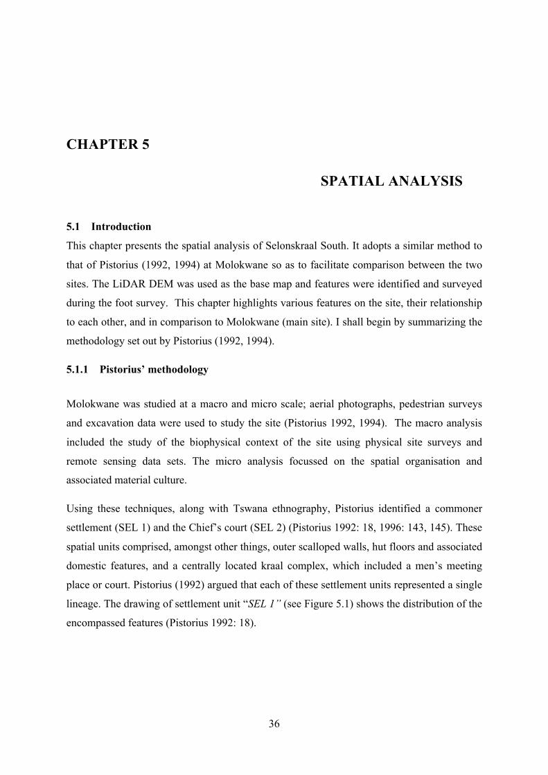
36
CHAPTER 5
SPATIAL ANALYSIS
5.1 Introduction
This chapter presents the spatial analysis of Selonskraal South. It adopts a similar method to
that of Pistorius (1992, 1994) at Molokwane so as to facilitate comparison between the two
sites. The LiDAR DEM was used as the base map and features were identified and surveyed
during the foot survey. This chapter highlights various features on the site, their relationship
to each other, and in comparison to Molokwane (main site). I shall begin by summarizing the
methodology set out by Pistorius (1992, 1994).
5.1.1 Pistorius’ methodology
Molokwane was studied at a macro and micro scale; aerial photographs, pedestrian surveys
and excavation data were used to study the site (Pistorius 1992, 1994). The macro analysis
included the study of the biophysical context of the site using physical site surveys and
remote sensing data sets. The micro analysis focussed on the spatial organisation and
associated material culture.
Using these techniques, along with Tswana ethnography, Pistorius identified a commoner
settlement (SEL 1) and the Chief’s court (SEL 2) (Pistorius 1992: 18, 1996: 143, 145). These
spatial units comprised, amongst other things, outer scalloped walls, hut floors and associated
domestic features, and a centrally located kraal complex, which included a men’s meeting
place or court. Pistorius (1992) argued that each of these settlement units represented a single
lineage. The drawing of settlement unit “SEL 1” (see Figure 5.1) shows the distribution of the
encompassed features (Pistorius 1992: 18).

37
Figure 5.1: SEL 1, a commoner “settlement unit” at Molokwane.
(Image use with permission from Julius C.C. Pistorius)
Pistorius (1992) adopted an historical and ethno-archaeological approach and adopted
Tswana terminology - motse (village), kgotla (men’s place of meeting), kgosing (central/
chief’s area), kgoro (hamlet), lapa (demarcated area around the hut). In this research the same
terminology will be used.
5.2 Selonskraal south - Macro-settlement features
Selonskraal South is made up of one composite cluster of stone walled settlement units on a
low isolated hill of 8, 9 hectares. Settlement units are more densely concentrated in the west
than in the east. The outer scalloping on this part of the site clearly stands out, with back
walls and central kraal complexes easily distinguishable. The same cannot be said of the
north east and eastern parts of the site where walling has been robbed, and is obscured under
dense tree cover.
Pedestrian surveys were conducted to ground-truth the LiDAR, and describe features. The
surveys revealed that some features on the site were overlooked during the imaging process.
Although, the base map was accurate, smaller details like entrances to kraals, monoliths,
benches and grain-bin bases were not discerned. These and other features within the walls,
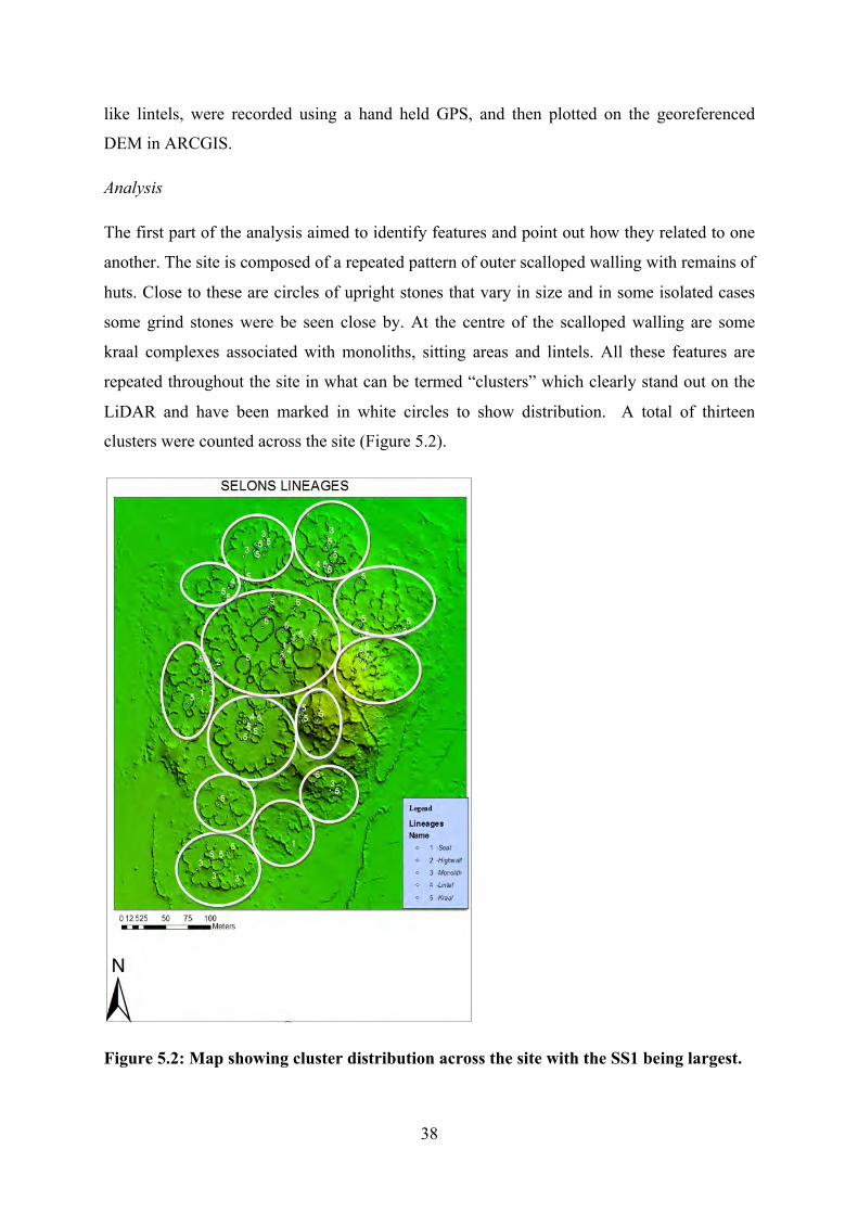
38
like lintels, were recorded using a hand held GPS, and then plotted on the georeferenced
DEM in ARCGIS.
Analysis
The first part of the analysis aimed to identify features and point out how they related to one
another. The site is composed of a repeated pattern of outer scalloped walling with remains of
huts. Close to these are circles of upright stones that vary in size and in some isolated cases
some grind stones were be seen close by. At the centre of the scalloped walling are some
kraal complexes associated with monoliths, sitting areas and lintels. All these features are
repeated throughout the site in what can be termed “clusters” which clearly stand out on the
LiDAR and have been marked in white circles to show distribution. A total of thirteen
clusters were counted across the site (Figure 5.2).
Figure 5.2: Map showing cluster distribution across the site with the SS1 being largest.

39
To get an idea of the differences in status the largest cluster unit (SS1) and the more typical
unit (SS2) are discussed further.
Lineage Unit SS1
SS1 has the following features:
o An outer wall consisting of 16 scallops which may suggest 16 households.
o Hut remains in the scallops (malapa)
o Circular features of upright stones in front of huts. These are about two metres in
diameter
o Semi-circular features of upright stones in front of the huts of ± a metre in diameter.
o An open area characterised by two bench like features facing a high walled kraal to
the south
The central part of SS1 is characterised by six kraal complexes of different sizes and facing
different directions. The following is a brief description of the features:
o A kraal over two metres high whose entrance is marked by a low lintel (partially
sealed)
o Two sitting platforms facing the high walled kraal
o Small and large kraals detached from each other, one with a wide entrance and neatly
laid out walls over a metre high
o An open area
Measurements of features in this cluster unit were taken. The area occupied by this unit is
approximately 490m² (0,05ha), which this makes it the largest cluster unit on the site. The
central kraal complexes occupy a space of approximately 322m² (0, 32ha) thus, the household
area approximately occupies 0,017ha. These measurements speak to the significance of the
central area (kraal complexes) over the household areas in this particular unit. The diameter
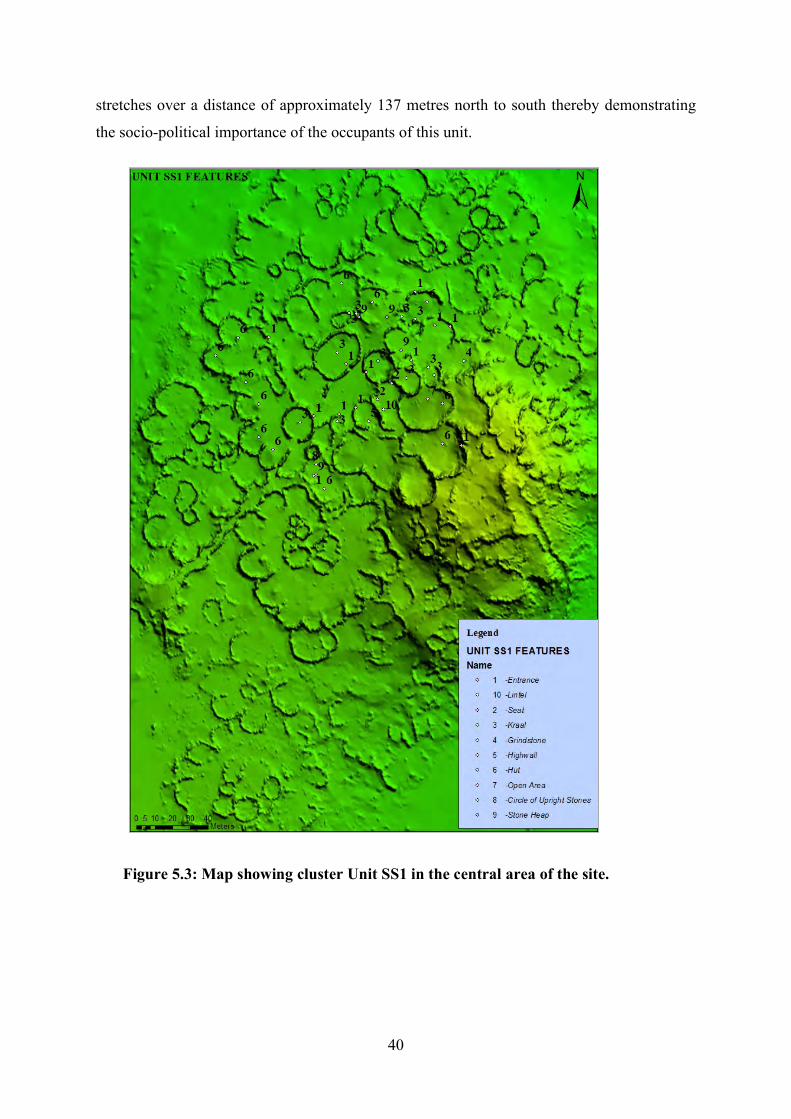
40
stretches over a distance of approximately 137 metres north to south thereby demonstrating
the socio-political importance of the occupants of this unit.
Figure 5.3: Map showing cluster Unit SS1 in the central area of the site.

41
Unit SS2- standard cluster unit
The area surrounding unit SS1 is characterised by smaller cluster units which are
predominantly identical in layout and distribution of features. One of these surrounding
cluster units, abutting SS1 to the south was selected for further analysis. The following
features are found in this settlement unit, which is hereby designated SS2 for the purposes of
this study.
o 13 small outer scalloped walls that contribute to a circular shape
o Hut remains in scallops (malapa)
o A horse shoe dent in the north to accommodate a winding pathway and an outer
scallop of SS1
o Circular features of upright stones in front of huts. These are about two metres in
diameter
o Semi-circular features of upright stones in front of the huts of ± a metre in diameter.
The following features are situated in the centre:
o Five kraal complexes; two large and three small. One small kraal has a low lintelled
entrance. Unlike the case in SS1, the central kraal complexes are all joined by a
secondary wall.
42
Figure 5.4: Map showing position and distribution of features in SS2.
5.3 Comparison with Molokwane
When compared with Molokwane, it is apparent that there is consistence in the ideological
layout followed suggesting little or no “foreign” influence. The arrangement and
composition of features in Unit SS1 corresponds with Unit SEL 2, the kgosing (place of the
chief) at Molokwane (Pistorius 1996). Among the similarities; the largest central kraal
complexes, one with a low lintel, high walling, an open area and kraals that appears to face
dwellings and pathways straddling middens as seen on entrance into SEL 1 at

43
Molokwane. Ascribing specific functions i.e. ceremonial kraal, ancestral graveyard and
private chamber to some kraals as did Pistorius (1996: 146) was not achievable in this study
because no excavations were done in SS1. In addition, the central kraal complexes in SEL 2
touch and are arranged in a circle with entrances facing a secondary space in the middle,
whereas, in contrast central kraals seems not to follow a particular order in SS1.
On the other hand, the commoner unit i.e. SEL 1 at Molokwane and SS2 at Selonskraal South
both appear to be more typical of the rest of both settlements. They both comprise outer
scalloped walls with dwellings, food processing and storage features (circles of upright
stones, rudimentary stone platforms), an intervening space and central kraals marked by a
monolith, and connected by secondary walls4. However, the two units have slight but
important differences; in SS2, unlike in SEL 1, one of the central kraals has a lintelled
entrance whereas no such occurs in SEL 1 at Molokwane. Similarly, SEL 1 has its own
unique features; stacked stone heaps, hearths and platforms that are not found in SS1.
5.4 Movement through the site
Movement in and out of the site would have been facilitated through three major stone
demarcated pathways; one to the south, another to the east and another to the north. These
paths separate cluster units on either sides (left or right) but do not curve to follow the
morphology of the curvilinear walling and are all spatially connected to the biggest cluster,
SS1, which is at the nucleus of the site. This reinforces the importance of the occupants of
this cluster and suggests that they had some measure of control over the way in which the
settlement was set out.
The southern pathway which straddles a midden, (Pathway number 1 in Figure 5.5) stretches
approximately 100 meters to reach unit SS1 whereas the eastern pathway (Pathway 2 in
Figure 5.5) stretches about 145 meters following a steep and rugged slope. Pathway 2 passes
a midden near the top, and also leads directly to a rectilinear structure located at the summit
(to be discussed later). Pathway 3 to the north (Figure 5.5) stretches approximately 95 meters
to Unit SS1 but its demarcation is not clearly defined. This may serve as evidence of
diachronic change over time through the robbing of walls to build other features. This
pathway is clearly visible on the ground but less on the LiDAR. The argument that it is a
path is based on physical site survey observations whereby kraals were seen opening up
to a long strip of passage that is devoid of grass leading out of the site. 4 For features in SS2 refer to this chapter above; for SEL 1 refer to Pistorius (1994: 40)

44
Movement throughout the settlement seems to have been set up for both humans and
livestock. There is a network of open spaces (not mapped) between settlement units and kraal
complexes. Open spaces suggest human movement. The cattle from Cluster SS1 would have
been driven through two passages; Pathway 1 and 3 (Figure 5.5). Cattle from other units
would have followed other smaller pathways possibly not visible on the LiDAR. Pathway 1
to the south is wide (approx. 5 metres) suggesting usage by a large herd of cattle. An
approximate figure of four animals would have walked abreast at a time. However, upon
entrance into “Cluster SS1” the path becomes narrower and has a sharp curve that makes this
idea problematic. The demarcating walling (between 1 and 1,5m in height) on this path does
not have openings to allow for usage by people or cattle from outside of SS1. By way of
observation, the movement along this path was not meant to be secretive as suggested by the
low walls.
Pathway 2 which is also about five metres wide was deliberately demarcated by upright
boulders on either side as it goes up the steep rugged slope to the summit. This path was
possibly only used by the elites.

45
Figure 5.5: Map showing major pathways at Selonskraal South leading to SS1.
The spatial set up of each lineage unit is more or less repeated across the site. However, there
are two lineage units; one to the north (unit 1) and another to the north-west (unit 2) which
have low lintels that were intentionally sealed (see Fig 5.7). The northern kraal (unit 1) has
two lintels; one facing north and another to the east. The east facing lintel of this unit (Unit 1)
is overlaid with layers of retouched stones. On the other hand, the north western kraal (Unit
2) is a result of two small kraals joined together to form an “8” shaped kraal complex. They
are connected together by a low sealed lintel. It is not possible to say whether the sealing is
permanent or temporary, functional or symbolic (Chapter 7). Figure 5.6 below shows the
position of these two kraals.

46
Figure 5.6: Map showing position of sealed lintels at Selonskraal South.

47
Figure 5.7: A sealed lintel in the north eastern anomalous kraal
5.5 Anomalies
A rectilinear structure was constructed at the top of the hill. It is located approximately 30
metres to the east of Unit SS1 and has retouched stone blocks. The material used to build the
structure looks identical to the rest of the site, but it is not spatially connected to the scalloped
walling. It is possible that it was constructed using material from existing walls. The LiDAR
imaging failed to capture this feature. The structure is built out of dry stone walling 50 – 60
cm thick, but less than half a metre high. The structure is approximately 9 metres wide and 10
metres long and has two entrances/ exits; one facing east and another facing west. A line of
stone blocks is visible in the floor (3 metres long approx) from the northern wall to
approximately the centre of the structure in the south.
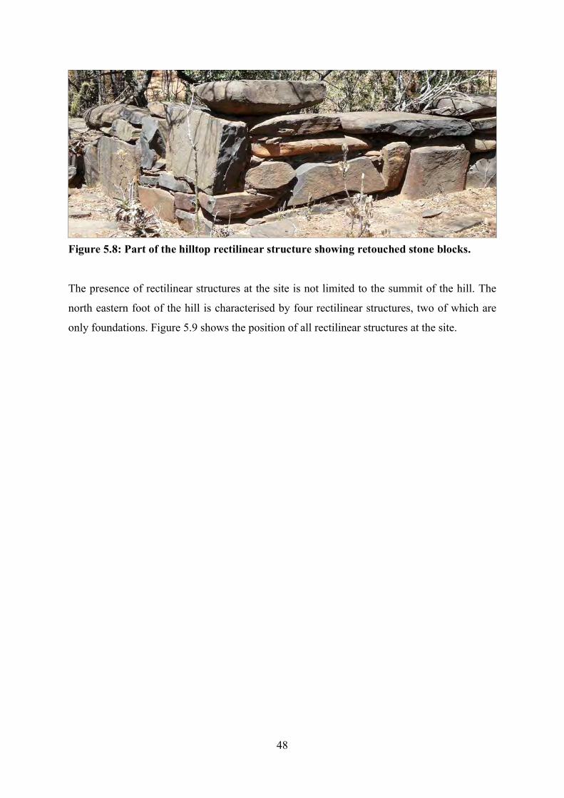
48
The presence of rectilinear structures at the site is not limited to the summit of the hill. The
north eastern foot of the hill is characterised by four rectilinear structures, two of which are
only foundations. Figure 5.9 shows the position of all rectilinear structures at the site.
Figure 5.8: Part of the hilltop rectilinear structure showing retouched stone blocks.

49
Figure 5.9: Map showing distribution of rectilinear structures.
Figure 5.10: one of the rectilinear structures at the base of the hill to the east

50
Objects that maybe associated with Europeans are scattered on the ground on the eastern foot
of the hill. These lie approximately 60 metres due-south of the north eastern foothill
rectilinear structures. These objects include; an iron nail, iron button, broken glass bottles and
a pin. These objects were not spatially associated with any features on the site. Figure 5.11
below shows the position where these artifacts were found. These objects were discovered
through intensive ground survey and were only present in this area. The ground surrounding
the rectilinear structure on the hill was thoroughly surveyed and nothing of European descent
was observed.
Figure 5. 11: Map showing position where European artifacts were recovered.

51
5.6 Isolated hut floors
The south eastern foothill has the remains of hut floors that are not associated with walling.
One hut has a feature that is best described as a furrow. From the way in which the walls have
collapsed it would appear that the furrow was enclosed within the structure. Its presence in
the hut may be symbolic and functional rather than decorative (Chapter 7). Pottery sherds
decorated with fine comp stamp decoration, dragged punctates and parallel lines of incisions
were discovered in association with these huts. The huts are not associated with the scalloped
walling but may have been enclosed in by walls that are just visible on the LiDAR. If they are
associated it might suggest an earlier occupation and the robbing of these walls to build the
main site.
Figure 5.12: Map showing position of hut floors at the base of the hill.

52
Figure 5.13: A furrow like feature within one of the isolated huts.

53
Fig 5.14: Potsherds recovered in association with the isolated hut on the southern hillbase
5.7 Conclusion
From the analysis, it is evident that Selonskraal South was built according to a mental
template that created uniformity across the site. This is unlike the case at Marothodi where
some sections of the site have some elements of earlier Nguni walling which was modified
into Molokwane type walling (Hall et al 2008). The uniformity is manifested through the
shape and composition of lineage units. Cluster SS1 appears to have been a centre of power
as suggested by its size, spatial connection and location. It would appear that this cluster was
occupied by the chief of the settlement complex. On the other hand, Cluster SS2 represents a
more typical cluster unit. Regardless of these consistencies, there are unique features i.e. the
rectilinear structures, isolated hut floors and the low sealed lintel kraals. When compared to
Molokwane a similar pattern can be observed which suggests occupation or authorship by
people of common descent. Although some features are unique to each of the clusters above,
they are found in other clusters across both settlements. The next chapter discusses the
stratigraphy and the excavation results.

54
CHAPTER 6
EXCAVATION DATA 6.1 Introduction
This chapter presents the excavation results and the analysis of the recovered material culture.
The profiles for trenches M1 and N1 are presented and the stratigraphy described. The
material culture is discussed and the results of the analyses presented.
6.2 Stratigraphy
Description of stratigraphy
The stratigraphy for both trenches was generally the same and had the following
characteristics; red brown - yellow soil with recurrent layers of black/ grey-white ash. Three
dung beetle nests and associated disturbance was evident in the NI southern wall (Figure 6.1)
but the other profiles were entirely undisturbed as shown
Figure 6:1: N1 stratigraphy southern wall profile.

55
Upon completion of excavation, photographs of the stratigraphy were taken and the
photographs were later uploaded into the drop box as back up. The wall profiles for both
trenches were drawn according to scale on graph paper and later digitally redrawn. The
excavated trenches were then backfilled.
As discussed in Chapter Four, excavation was done in 5cm spits to maximise vertical
control. However, stratigraphic layers were clearly visible in the sections and the stratigraphic
profiles in both trenches showed a clear repeated pattern of ash and soil layers (see Figures
6.1&2).
Figure 6.2: M1 West wall profile.
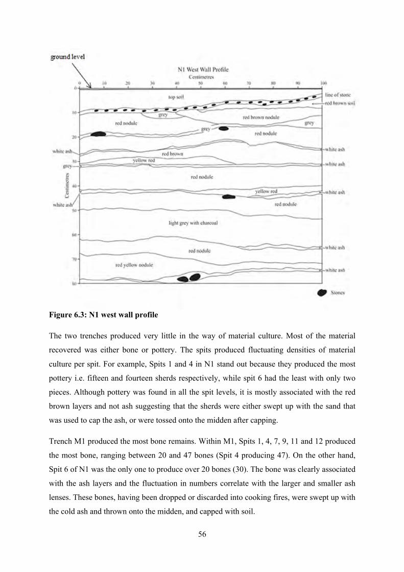
56
Figure 6.3: N1 west wall profile
The two trenches produced very little in the way of material culture. Most of the material
recovered was either bone or pottery. The spits produced fluctuating densities of material
culture per spit. For example, Spits 1 and 4 in N1 stand out because they produced the most
pottery i.e. fifteen and fourteen sherds respectively, while spit 6 had the least with only two
pieces. Although pottery was found in all the spit levels, it is mostly associated with the red
brown layers and not ash suggesting that the sherds were either swept up with the sand that
was used to cap the ash, or were tossed onto the midden after capping.
Trench M1 produced the most bone remains. Within M1, Spits 1, 4, 7, 9, 11 and 12 produced
the most bone, ranging between 20 and 47 bones (Spit 4 producing 47). On the other hand,
Spit 6 of N1 was the only one to produce over 20 bones (30). The bone was clearly associated
with the ash layers and the fluctuation in numbers correlate with the larger and smaller ash
lenses. These bones, having been dropped or discarded into cooking fires, were swept up with
the cold ash and thrown onto the midden, and capped with soil.

57
6.3 Dating the occupation
Charcoal samples from Spit 4 and Spit 16 were selected for carbon dating. Spit 4 (28-33cm)
produced a radio carbon age of 120±43 BP using the Schal13.14c data set. On the other hand,
Spit 16 (88-93cm) produced a radio carbon age of 380±51BP therefore placing the earlier
occupation in the 16th century or early part of the 17th century (See Appendix for results of
carbon dating).
6.4 Excavated material
6.3.1 Faunal material
The faunal analysis was done in order to understand what animals were represented in the
collection. There was emphasis on the identification of species, Number of Identifiable
Species counts (NISP) and distribution throughout the levels to detect any change over time.
In addition, a basic taphonomic analysis was done in order to understand possible meat
processing traits.
The NISP count for M1 is 288 bones whilst 148 bones were recovered in N1 (Table 6.1).
This produced a combined NISP of 436 bones. There was more material in M1 than in N1
possibly because M1 was the centre of the midden where most of the discarded refuse would
have accumulated.
Table 6.1: NISP counts for M1 and N1
Trench NISP
M1 288
N1 148
TOTAL NISP 436
The number of bones was plotted onto graphs to show the density and fluctuations throughout
the stratigraphy (Fig 6.4 and 6.5).
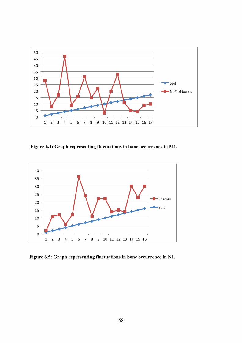
58
Figure 6.5: Graph representing fluctuations in bone occurrence in N1.
0
5
10
15
20
25
30
35
40
1 2 3 4 5 6 7 8 9 10 11 12 13 14 15 16
Species
Spit
0
5
10
15
20
25
30
35
40
45
50
1 2 3 4 5 6 7 8 9 10 11 12 13 14 15 16 17
Spit
No#ofbones
Figure 6.4: Graph representing fluctuations in bone occurrence in M1.

59
6.3.2 Species represented
Five species were represented in the faunal assemblage; Redunca fulvorufula (Reedbuck),
Tragelaphus strepsiceros (Kudu), Bos taurus (Cow), Gallus gallus domesticus (Chicken) and
the Taurotragus oryx (Eland). Among these species, the Taurotragus oryx (Eland) was
recovered in both trenches.
The identified species were recovered between Spits 3 and 13 in both trenches and among
these cattle are the most common (57% of identified species). In terms of variety, there is a
balance between wild and domestic species i.e. 3 wild (Redunca fulvorufula, Taurotragus
oryx and Tragelaphus strepsiceros) and two domesticates (Bos Taurus and Gallus gallus
domesticus). Tables 6.2 and 6.3 shows the distribution of species in both trenches:
Table 6.2: M1 species list at Selonskraal South
M1 Spit
Depth (cm)
No# of bones
Species Diagnostic element
3 23-28 17 Redunca fulvorufula (Reedbuck) Proximal Phalanx (left) Bos taurus (Cow) Hyoid (Right) Tragelaphus strepsiceros (Kudu) Tooth 4 28-33 47 Bos taurus (Cow) Styloid Process (Left) Bos taurus (Cow) Distal Tibia (Left) 7 43-48 31 Redunca fulvorufula (Reedbuck) Tooth (Molar 1) Gallus gallus domesticus (Chicken) Ulna (Left) 9 53-58 22 Bos taurus (Cow) Astragulus 10 58-63 3 cf. Taurotragus oryx (Eland) Metacarpal
Table 6.3: N1 species list at Selonskraal South.
N1 Spit
Depth (cm)
No# of bones
Species Diagnostic element
4 20-25 2 Bos taurus (Cow) Scaphoid (Left) 5 25-30 7 Bos taurus (Cow) Tooth (Second Molar) 6 30-35 30 Bos taurus (Cow) Scapula 8 40-45 3 Bos taurus (Cow) Second Phalanx 13 65-70 1 Taurotragus oryx (Eland) Molar

60
Table 6.4: NISP and MNI of particular species at Selonskraal South.
Taxon (common name) NISP MNI
Gallus gallus domesticus (Chicken) 1 1
Bos taurus (Cow) 8 8
Taurotragus oryx (Eland) 2 2
Tragelaphus strepsiceros (Kudu) 1 1
Redunca fulvorufula (Mountain Reedbuck) 2 2
Total 14 14
6.3.3 Element representation
A combined total of 40 bones could only be identified to element level because they lacked
the morphological characteristics necessary for identification to species level. From these, a
total of 25 bones are from M1 which comprises 8, 7% of the total NISP in M1 (288 bones).
On the other hand, 15 were recovered from N1 forming 10, 1% of the total NISP. The
combined percentage of identifiable elements is 9, 2% from a combined NISP of 436 bones.
Ribs are the most occurring elements in both excavations with 20% coming from M1 while
33 % came from N1.
Table 6.5: Elements that could not be identified to species.
Element
Bovid
Size
Class Side (R- Right- Left L) Quantity
Tibia 3 or 4 R 3
Radius 4 - 1
Rib 4 R 1
Maxillary pallette 3 or 4 - 1
Metacarpal 4 Indeterminate 1

61
Tooth fragment 3 or 4 Mandible and IND 1
Cranial bone 3 or 4 - 1
Tibia 4 Indeterminate 1
Tibia 2 or 3 Indeterminate 1
Rib 2 or 3 R 1
Tooth enamel - - 1
Femur/tibia 2 - 1
Rib 3 or 4 L 1
Rib 4 L 1
Rib 3 or 4 R 3
Scapula 2 or 3 Indeterminate 1
Metacarpal 2 or 3 1
First phalanx 3 Indeterminate 1
Rib 3 or 4 Indeterminate 2
Rib 2 or 3 Indeterminate 1
Coracoid process 3 or 4 R 1
Pelvic bone 2 or 3 - 1
Rib 2 L 1
Scaphoid - - 1
Pre-maxilla 2 or 3 R 1
Transverse process 3 or 4 - 1
Femur 3 R 1

62
Tibia 3 or 4 L 1
Transverse (lumbar)
process 4 - 1
Tibia 2 R 1
Rib 3 Indeterminate 1
Second phalanx 4 R 1
Scapula - Indeterminate 1
Rib 2 or 3 L 2
6.3.4 Species ecology
The identified species historically occur in the Rustenburg area because they prefer the
Savanna/ Bushveld biomes (cf Skinner and Chimimba 2005). The Redunca fulvorufula
(Mountain Reedbuck) thrives in dry, grass covered and stony slopes with tree cover of the
Savanna biome (Skinner and Chimimba 2005: 679). Similarly, the Tragelaphus strepsiceros
(Kudu) and the Taurotragus oryx (Eland) flourish in rocky areas, savanna woodlands, with
the Taurotragus oryx preferring the Grasslands. The Savanna/ Grassland biomes produce
vegetation and water supply necessary for the identified species to thrive (Skinner and
Chimimba 2005: 628, 638-639).
In the study area, the identified species were also found at Molokwane, Boitsemagano and
Kaditshwene (Pistorius and Plug 2001; Boeyens and Plug 2011). The Gallus gallus
domesticus (chicken) was excavated only at Kaditshwene and Mabyanamatshwaana and in
low frequency (Plug and Badenhorst 2006: 58, 60; Boeyens and Plug 2011: 1). Cypraea sp.
(Cowrie shell) is a marine organism and would have found its way to Selonskraal South
through trade with communities closer to the sea. Cowrie shells formed part of the Indian
Ocean Trade Network (Moffet and Chirikure 2016), and were regularly used by diviners
(Pwiti 1996: 133, 150; Tiley and Burger 2002).
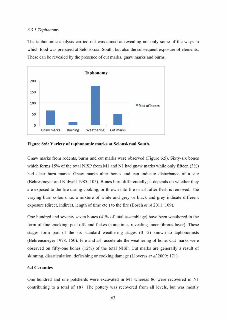
63
6.3.5 Taphonomy
The taphonomic analysis carried out was aimed at revealing not only some of the ways in
which food was prepared at Selonskraal South, but also the subsequent exposure of elements.
These can be revealed by the presence of cut marks, gnaw marks and burns.
Figure 6:6: Variety of taphonomic marks at Selonskraal South.
Gnaw marks from rodents, burns and cut marks were observed (Figure 6.5). Sixty-six bones
which forms 15% of the total NISP from M1 and N1 had gnaw marks while only fifteen (3%)
had clear burn marks. Gnaw marks alter bones and can indicate disturbance of a site
(Behresmeyer and Kidwell 1985: 105). Bones burn differentially; it depends on whether they
are exposed to the fire during cooking, or thrown into fire or ash after flesh is removed. The
varying burn colours i.e. a mixture of white and grey or black and grey indicate different
exposure (direct, indirect, length of time etc.) to the fire (Bosch et al 2011: 109).
One hundred and seventy seven bones (41% of total assemblage) have been weathered in the
form of fine cracking, peel offs and flakes (sometimes revealing inner fibrous layer). These
stages form part of the six standard weathering stages (0 -5) known to taphonomists
(Behrensmeyer 1978: 150). Fire and ash accelerate the weathering of bone. Cut marks were
observed on fifty-one bones (12%) of the total NISP. Cut marks are generally a result of
skinning, disarticulation, defleshing or cooking damage (Lloveras et al 2009: 171).
6.4 Ceramics
One hundred and one potsherds were excavated in M1 whereas 86 were recovered in N1
contributing to a total of 187. The pottery was recovered from all levels, but was mostly
0
50
100
150
200
Gnawmarks Burning Weathering Cutmarks
Taphonomy
No# of bones

64
associated with the red brown layers. The distribution of the pottery in all spits (ashy and red
brown soils) suggest that the users of the midden constantly discarded broken pots and that
they may not have been subject to the same cultural considerations as with ash and its
contents (Chapter Seven). The upper spits produced more sherds than the lower spits but the
pottery is made from the same micaceous temper throughout all the levels.
The pottery was sorted into diagnostic and non-diagnostic subgroups. As such, nine sherds
(9%) were regarded as diagnostic from M1 whereas only four (5%) were diagnostic from N1
and all are rims. The excavated pottery is characteristic of Buispoort pottery, which is typical
of sites associated with Western Tswana speakers and it is classified as such in this research.
On the other hand, the decorated pottery (comp-stamp, parallel lines of incisions and
punctates) at the south eastern base of the hill is classified as Uitkomst, a ceramic type that
has been associated with Nguni speakers (Huffman 2007). A multivariate analysis (Huffman
1980: 123) was carried out (though not comprehensive because the assemblage is too small
and fragmented) to classify the pottery according to its characteristics.
6.4.1 The multivariate analysis
Vessel Profile
This brief multivariate analysis was done using Hall’s (1998: 250) Moloko ceramics classes.
Two vessel types were identified from M1 (Figure 6.6), recurved jars (a, b, e, f, h, j and k)
and neckless jars (c, g and i). These potsherds which are all rims were excavated in Spits 2, 3,
5, 7, 8, 11, 12, 13 and 14. They all share similar characteristics with those recovered in N1.
One recurved jar with a lip was recovered on the ground (Figure 6.7) and it also has similar
characteristics with those already discussed.
One vessel class was identified from N1 pottery (Figure 6.8), i.e. recurved jar. Recurved jar
“A” does not have a neck while the rest does. Recurved jar “b” has a raised and applied
triangular band just below the lip and it appears to have been functional as well as decorative.
It may have functioned to secure the position of human lips while drinking. These vessels
were recovered in Spits 7, 9, 13 and 15 and they all have common characteristics - lack of
decorations and have a micaceous temper. This is significantly different from the decorated
pottery from the base of the hill which was not tempered.

65
Figure 6.7: Vessel profiles from M1.
Figure 6.8: Vessel profile from the surface findings.

66
Figure 6.9: Vessel profiles from N1.
Decoration motif and technique
A single rim sherd labeled “b” from M1 (Figure 6.6) was decorated with the “rim nicking
technique”. The surfaces of the vessels were all burnished but this is not regarded as a
decoration technique. A comprehensive analysis was not possible because the pottery is
largely undecorated, and the excavated sample was too small. No multivariate analysis was
done on the pottery from the base of the hill to the east.
6.4.2 X-Ray Fluorescence Analysis
The XRF analysis of samples selected from M1 Spits 1, 2 and 13 and N1 Spit 1 has suggested
that the potters used similar clay because they have similar chemical signatures. In addition,
the samples all have a micaceous temper (shiny lustrous element). Meanwhile, the decorated
pots from the base of the hill to the south east have a different chemical make-up. The clay is

67
different and there are no mineral inclusions as is the case with the excavated pottery. This
suggests that the pottery was made from a different clay source and by a different potter.
6.4.3 Ostrich eggshell beads
Only six ostrich eggshell beads were recovered. Six of these were recovered during the
testing of the midden with the auger. These beads vary in size, ranging from 4 – 5mm in
diameter with different thicknesses. These all seem to have been made using two distinct
techniques because the dimensions do not have a similar craft pattern. Two of these ostrich
eggshell beads stand out – they have more well rounded edges than the rest, suggesting
different techniques or a different maker. Apart from these observations, no other analysis
could be done because the sample is too small.
Table 6.6: Distribution of ostrich eggshell beads.
Trench Spit Number of
beads
Diameter
(mm)
M1 1 (0-18cm- overshot
spit)
2 (one broken) 5
3 (23-28 cm) 2 5
N1 2 (0-10cm) 1 4
Auger hole
1
64- 75cm 1 5
Figure 6.10: Ostrich eggshell beads from Selonskraal South

68
6.4.4 Marine shells
A fully preserved cowrie shell was recovered in Spit 8 (48-53cm) of Trench M1 (Figure
6.10). There is no visible evidence of retouching on its outer surface thus maintaining the
original white smooth surface. In addition, 3 shell pieces were recovered in Spits 12 and 17 of
the same trench whereas one fragment was found in trench N1 Spit 13.
Figure 6.11: Fully preserved cowrie shell from Selonskraal South.
6.4.5 Iron pieces, charcoal & materials from the foot of the hill
Three iron pieces were recovered from the augur hole 2 at a depth of 87-90 cm. This
corresponds roughly with Spits 15 and 16 which dates to the 17th century (to be discussed
below). In addition, another iron piece was recovered in augur hole seven at the depth of 6-
12cm thus corresponding with 19th century occupation reflected in Spit 4 (to be discussed).
Charcoal was recovered in both trenches and in all spits in considerable quantities. The
charcoal from Spits 4 and 16 of M1 was dated but no other analysis was carried out.
Other iron pieces along with European ceramics were recovered at the base of the hill to the
east. These were not spatially associated with any architecture and they appear to have been
machined suggesting deposition in the 20th century.
6.6 Discussion & conclusion
The carbon dates suggest an early date for Buispoort pottery. However, further excavation
would need to be carried out to determine whether this date can be applied to the scalloped
walled settlement on the hill. In addition, a comprehensive discussion about the known dates
for Buispoort pottery may not be possible because only one date was obtained from
Selonskraal South. It is possible that there was an earlier occupation on and around the hill.
The partially buried and possibly robbed walls are visible on the LiDAR, particularly to the

69
south of the hill. This area also contains hut floors that are not enclosed by walling (see
Chapter Five), and comp stamped, incised and punctated pottery with a different chemical
signature (see Appendix). Whatever the case, the excavated midden used to dispose of
cooking fires from the inception of the settlement.
At the summit midden, the excavated Buispoort pottery was made from a similar clay source
from the earliest occupation (Spit 16, 17 & 18) until the last occupation in the 19th century.
These and other themes will be discussed further in Chapter Seven.

70
CHAPTER 7
DISCUSSIONS & CONCLUSION 7.1 Introduction
The major aim of this research is to understand how Selonskraal South fits in space and time
relative to Molokwane and other known sites in the region. To achieve this goal a study of
spatial layout was carried out and a midden was excavated. This chapter, and the study are
concluded with recommendations for future studies at the site.
7.2 Spatial data
Selonskraal South follows the Central Cattle Pattern layout (Huffman 1982: 140, 1986:289,
2007: 33, 2010), and resembles the Molokwane type walling associated with the Western
Tswana. Molokwane type sites have a classic Central Cattle Pattern layout with; outer
scalloped walls containing huts facing centrally located kraals (Pistorius 1992; Huffman
2007). The site comprises thirteen settlement units organised like “SEL 1”, a commoner
settlement unit at Molokwane (Pistorius 1992). These settlement units, occupied by people of
the same lineage, were the dikgoro headed by a headman who reported to the chief (Alverson
1978; Pistorius 1992). These thirteen lineage units aggregate form the motse (village-
Selonskraal South).
The organisation of space among the Tswana after the introduction of walling (second half of
the 17th century) was gender related (Hall 1998). The central zone of the settlement unit
(dikgoro) was a centre of male wealth and dominance because cattle kraals and the kgotla
(male court) were located there (Walton 1958: 133; Alverson 1978; Kuper 1980: 17;
Huffman 1982: 140; Pistorius 1992). These cattle kraals were symbolic of a man’s ability to
cater for his wife and gain paternity over his children (Alverson 1978: 130). Cattle kraals also
served as the kgotla where the headman presided over hearings and male meetings. In some
cases, the areas around the entrance into the cattle kraals were used as the kgotla (Walton
1958: 133; Kuper 1980: 17; Huffman 1982: 140).
The presence of monoliths across the site (Chapter Five) represents widespread symbolic
thinking. These features represented various aspects; male dominance, ceremonial and
political significance of the associated space or the power of the chief (Walton 1958: 135,
138; Anderson 2009: 123, 237). While at Selonskraal South these were found in association

71
with kraals, among the Fokeng (Tswana-ised Nguni), they were used as markers of the
chief’s grave (Walton 1958: 138).
The central kraals at Selonskraal South had low lintels like the chief’s court in “SEL 2” and
to the headman’s kgotla in “SEL 1” at Molokwane (Pistorius 1992: 26, 63). As at
Molokwane, the central kraals at Selonskraal South were adjoined to smaller kraals (with
lintels) with a secondary wall. Such small kraals have been associated with calves and other
small stock (Walton 1958: 133; Huffman 2007: 133). Both kraals have walls over two metres
high (Figure 7.1). Such a setup was also found at Kaditshwene where the entrance into the
chief’s kgotla has walls over 8 feet (about 2, 44 metres) high (Campbell 1822: 222, 223).
Figure 7. 1: Lintel on entrance into the kraal that abuts the chief’s kgotla at Selonskraal South.
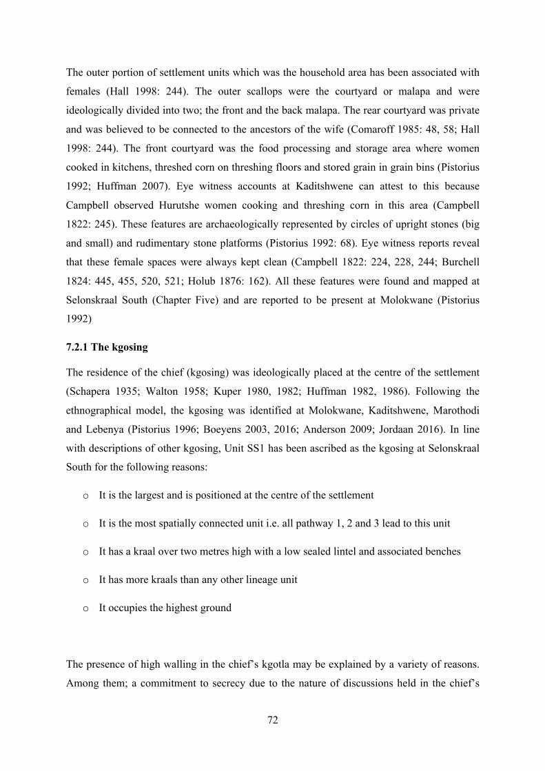
72
The outer portion of settlement units which was the household area has been associated with
females (Hall 1998: 244). The outer scallops were the courtyard or malapa and were
ideologically divided into two; the front and the back malapa. The rear courtyard was private
and was believed to be connected to the ancestors of the wife (Comaroff 1985: 48, 58; Hall
1998: 244). The front courtyard was the food processing and storage area where women
cooked in kitchens, threshed corn on threshing floors and stored grain in grain bins (Pistorius
1992; Huffman 2007). Eye witness accounts at Kaditshwene can attest to this because
Campbell observed Hurutshe women cooking and threshing corn in this area (Campbell
1822: 245). These features are archaeologically represented by circles of upright stones (big
and small) and rudimentary stone platforms (Pistorius 1992: 68). Eye witness reports reveal
that these female spaces were always kept clean (Campbell 1822: 224, 228, 244; Burchell
1824: 445, 455, 520, 521; Holub 1876: 162). All these features were found and mapped at
Selonskraal South (Chapter Five) and are reported to be present at Molokwane (Pistorius
1992)
7.2.1 The kgosing
The residence of the chief (kgosing) was ideologically placed at the centre of the settlement
(Schapera 1935; Walton 1958; Kuper 1980, 1982; Huffman 1982, 1986). Following the
ethnographical model, the kgosing was identified at Molokwane, Kaditshwene, Marothodi
and Lebenya (Pistorius 1996; Boeyens 2003, 2016; Anderson 2009; Jordaan 2016). In line
with descriptions of other kgosing, Unit SS1 has been ascribed as the kgosing at Selonskraal
South for the following reasons:
o It is the largest and is positioned at the centre of the settlement
o It is the most spatially connected unit i.e. all pathway 1, 2 and 3 lead to this unit
o It has a kraal over two metres high with a low sealed lintel and associated benches
o It has more kraals than any other lineage unit
o It occupies the highest ground
The presence of high walling in the chief’s kgotla may be explained by a variety of reasons.
Among them; a commitment to secrecy due to the nature of discussions held in the chief’s

73
kgotla (Pistorius 1992; 1996: 157), it confers both physical and spiritual protection, and
reinforces importance and the Chief’s ability to command labour. In addition, high walling
defines the back walls of the ruling lineage and serves as a marker of the position of senior
wives’ or the chief’s homestead behind. The largest malapa are found behind these walls
while the largest in SEL 2 at Molokwane were also ascribed to the chief (Pistorius 1996:
146). Therefore, the kgosing at Selonskraal South was built according to the same ideological
concept as SEL 2, the kgosing at Molokwane.
The lack of excavations in SS1 meant that functions could not successfully be ascribed to the
central kraals as did Pistorius (1994, 1996). However, there are significant similarities in the
orientation and appearance of central kraals with those in SEL 2. These kraals would have
been; ancestral graveyards, ceremonial kraals, cattle kraals and private chambers (Pistorius
1996: 146). The significance of the central areas in both kgosing is demonstrated by how they
both occupy larger areas than the household areas (Chapter Five). This emphasizes the
political significance of these spaces.
7.2.2 Micro-settlement spatial anomalies
Selonskraal South architecture possibly suggests early European influence through the
presence of rectilinear structures. If this is the case, these rectilinear structures (Chapter Five)
may be regarded as time markers and may represent the spread of Christian ideas into African
Traditional beliefs. The earliest Europeans to arrive in the study area appeared at the turn of
the 19th century and they sought to influence and change African life-ways (Crosland 2013).
These rectilinear structures may therefore symbolise some level of influence. It is notable that
the surrounding known sites i.e. Olifantspoort 20/71, Molokwane, Marothodi, Lebenya and
Kaditshwene lack such architecture, causing Selonskraal South to stand out.
Although no European material was found within these structures to provide a direct link
with Europeans, it is assumed that rectilinear structures started to be embraced around
AD1860 (Frescura 2015). A post AD1860 date for rectilinear structures would tally with Spit
4 carbon dates (120±43), and may therefore fit with the idea that these structures were most
likely later additions. The lack of European material within these structures suggests the
adoption of foreign ideas by the Tswana. The European materials on the foot of the hill to the
east was probably discarded by the early European farmers on farm Selonskraal sometime in
the 20th century. There is a possibility that this structure can be linked to the Anglo Boer War
(e.g. Carruthers 1990), however they lack the characteristics of a fort.

74
The hut floors on the southern side of the hill are different and may represent either remnants
of an earlier occupation or cohabitation with foreign people, or huts of a different function.
The decorated pottery identified as Uitkomst is thought to have been made by people with
Nguni descent and to date back to the 1650s (Huffman 2007: 171). However, others have
argued that comb-stamp and Buispoort occur together. Whatever the case, the decorated
pottery appears to have been brought into the site because the clay has a different chemical
signature and no micaceous temper. The absence of lobed walls and domestic features that
surround the other huts would either suggest a difference in spatial layout and therefore a
foreign influence. The possibility of Nguni influence is not far-fetched. Historically speaking,
Nguni communities are said to have occupied the region e.g. the Tlokwa, Tlhako, Kgatla and
the Po (Hall et al 2008). However, the furrow like feature in one of the huts has no
archaeological correlate and this feature may speak to the function of the hut rather than to
identity. The furrow may also have had some symbolic meaning. It may have served the same
function as a platform for the storage on ancestral spears and pots (See Hall 1998; Fredriksen
2007). If this was the case, then this feature would a symbolic dimension representing the
spirituality of the architects.
The two low lintelled curvilinear kraals (K1 and K2) in the two lineage units mapped in
Chapter Five also stand out as unique. Firstly, by way of analogical reasoning, K2 (the north
eastern kraal with two sealed lintels) may symbolise the death of the headman or end of that
lineage. Among the Tswana, lineage units were named after and headed by a senior headman
(Schapera 1935). The death of such a figurehead was possibly accompanied by symbolisms
like the closure of the associated kgotla for a period of time. However, a kgotla is not
historically known to have had two lintels. Instead, the two closed lintels in K1 along with K2
(the double kraal in the north) may have served a different ritual function. These kraals
compare closely with Tswana “circumcision lodges” for boys illustrated by Huffman (2007:
63). These are said to be found at Gananwa (Roberts and Winter 1915 in Huffman 2007: 63).
However, boys were initiated outside Tswana settlements (Brown 1921; Huffman 2007: 61,
62). Instead, it was the girls that were initiated within settlements near the chief’s kraal in
“small kraals” (Huffman 2007: 62).
The carbon dates suggest a long occupation of people using Buispoort pottery. Whether the
scalloped walling is as early as the pottery needs to be tested. However, little can be done in
this research because more dates are required to make a comprehensive comparison with the
later dates associated with Buispoort pottery and stone walling. Such a lengthy occupation

75
would naturally suggest successive rulers so that primary and secondary kgosings can be
expected to be distinguishable on the map. This is the case at Marothodi and Kaditshwene
where two kgosing can be seen and attributed to Chief Bogatsu and his successor (Anderson
2009: 99; Boeyens and Plug 2011: 4). It is possible that the kgosing at SS1 was repeatedly
reoccupied, possibly with later modifications e.g. the rectilinear structure at the summit.
Pistorius (1992) found something similar in that one of the kgosing at Molokwane was
occupied through several generations without a break (Pistorius 1992; Boeyens 2003: 69).
7.2.3 Macro settlement variations
On a micro perspective, Selonskraal South is predominantly similar to Molokwane,
Kaditshwene, Marothodi and Olifantspoort. However, there are some important differences at
macro level such as the absence of the ideological “Threefold division” which is only found
at the larger sites of Molokwane, Marothodi and Lebenya (Pistorius 1996: 145; Anderson
2009: 76; Jordaan 2016: 95). The tripartite division was an ideological set up of settlements
consisting of; the central part (fa gare), upper part (ntlha ya godimo) and lower (ntlha ya
tlase). These divisions were markers of status; central division for the Chief, his wives,
children, married sons and long-time foreigners. In contrast, the flanking divisions were for
the royal brothers, paternal uncles of the chief, commoners and immigrants (Hardie 1981:44
in Pistorius 1994: 49; Pistorius 1994: 49; Boeyens 2003: 71). Selonskraal South is composed
of one composite cluster of settlement units on a low isolated hill (Chapter Five). However, it
could mark the position of uncles or brothers to the Chief at Molokwane. It is possible that
the head of the SS settlement complex was a vassal of Molokwane for a period of time
especially under the reign of the powerful Chief Kgaswane who had control over seven other
polities in the Rustenburg area (see Breutz 1953).
Selonskraal South has its own social stratification as illustrated by the differences in size of
settlements units and walling height and quality. The settlement is an outlier of Molokwane
which appears to have been occupied concurrently with Molokwane. It is also possible that
the settlement was originally settled by different people at base of the hill and who either
moved on or later adopted western Tswana architecture on the hill.
Selonskraal South is not located on a defensible position like Kaditshwene (Boeyens 2003:
63). Eye witness reports have revealed that the placement of sites on mountain or hilltops was
meant to provide defence by means of elevation advantage, inaccessibility or concealment of
settlements from view (Campbell 1822; Kay 1833: 234). While this may be true of sites in

76
the Marico, it is not the case for Molokwane, Marothodi and Olifantspoort in the Rustenburg
area. These sites which all predate the significant warring times of the 19th century are
located on slightly elevated landscapes that could not have offered significance defensibility
(Mason 1986: 351, 358; Pistorius 1992; Anderson 2009: 76). Thus, the location of sites was
not always influenced by the need for defence but also due to advantages associated with the
chosen area, possibly proximity to water sources and grazing lands. In the old Western
Transvaal, war emerged in the 1800s when communities came into conflict with each other
(Hall et al 2008: 55), and were forced to abandoned these sites between the 1820 and 1830.
Like Molokwane and Boitsemagano Selonskraal South lacks evidence for metal working.
This scenario hints at a regional trade from large metal working towns like Marothodi where
abundant metalworking furnaces were found (Hall et al 2006; Anderson 2009), or at
Kaditshwene where eye witness accounts report on metal working stations (Campbell 1822).
Campbell (1822: 240-241) recorded that the Hurutshe at Kaditshwene traded beads with the
“Boquains called Molloquam” (Possibly the Bakwena of Molokwane). Similarly, the
presence of Buispoort pottery at Marothodi points to trade with the Kwena in the Rustenburg
area.
7.3 Faunal material
The faunal assemblage from the site offers clues about the food preparation and consumption,
as well as social or economic stratification among the occupants of the motse. The
identification of Eland bones hints at royal or elite usage of the midden. Eland meat was
mostly a preserve for the elites and from the 17th century, the San and the Bakgalagadi were
“employed” by Tswana elites to hunt these animals (Morton and Hitchcock 2013: 435). This
fits with the location of the midden at the summit of the hill where the elites are historically
known to have resided.
The presence of a chicken ulna may further speak to prestige by the elites. Chicken was only
found at Molokwane and Mabjanamatswaana (Pistorius 1997), in low frequencies suggesting
rarity in the region.
Sea shells and a perforated proximal phalanx of a Redunca fulvorufula (Figure 7.2) suggest
the presence of a diviner in the royal/ elite lineage. The proximal phalanx was either part of a

77
diving set or worn around the neck. Some divining sets included pieces made of bone or
wood that were perforated (Plug 1987: 52). Sea shells were common among divining sets of
the medicine men (dingaka) and oftentimes had multiple meanings. Among the Pedi, sea
shells meant water divination whilst among the Kgatla Kgafela they were regarded as
“elephant of the sea” while to others the shells represented female qualities (Plug 1987: 55).
Sea shells were recovered also at Molokwane and Mabyanamatswaana in low numbers
(Pistorius 2001: 31). This provides a valuable index of connection with the Indian Ocean
Trade Network and we know from traveller reports that the people at Kaditshwene had
contact with the sea (Campbell 1822).
The faunal material also informs one of the food consumption habits at the site. The cut
marks reveal use of sharp utensils to carve the meat. This suggests sharing or eating as
witnessed at Kaditshwene by Campbell (1822: 235):
…full of boiled flesh which he cut with a knife, holding the ends of the bones in his
left hand while he cut off meat. He seemed to act as a chief carver…
The capping of ash with soil may suggest similar beliefs to some Nguni groups. The
occupants of the site may have capped the ash to avoid exploitation for witchcraft by
enemies. Among the Zulu, there was belief that ash can be used by enemies to bewitch
Figure 7.2: Perforated proximal phalanx of a Redunca fulvorufula.

78
people (Raum 1973: 146, 152). However, at Selonskraal South capping the ash may have
been done simply to restrict the spread of the ash (cf Anderson 2009: 199).
7.4 Pottery and walling
The excavated Buispoort pottery was found in association with the Molokwane type walling
at Selonskraal South. Huffman notes that Buispoort pottery dates from AD1650-1830.
However, carbon dates from spit 16 (380± 51) suggests that the excavated Buispoort pottery
may have been there even earlier. The aggregated walling is generally thought to have started
around AD1650 -1700 (Boeyens 2003), thus the carbon dates from Selonskraal South begs
the question if Buispoort pottery predates stone walling. Micaceous temper was used
throughout the occupation and this is consistent with the clays used at Molokwane,
Kaditshwene, Olifantspoort and Marothodi. This was thought to be an innovation during the
era of stone walling i.e. post AD1700 (Rosenstein 2002: 38, 2008).
There is a presence of Uitkomst and Buispoort pottery at Molokwane, Kaditshwene,
Marothodi and Selonskraal South (Pistorius 1984; Anderson 2009; Boeyens and Hall 2009).
With the exception of Marothodi, all the sites have more Buispoort pottery than Uitkomst
which occurs is very small quantities. At Marothodi, there is thought to have been frequent
intermingling of the Tlokwa (Nguni) and the Tswana because the Molokwane type walling is
also apparent (Anderson 2009; Hall 2012: 312). The site at Lebenya (no carbon dates)
presents another dynamic in that Buispoort pottery was found in association with
Klipriviersberg type walling (Jordaan 2016: 171). These inconsistencies suggest the fluid
movement of people and that the rigid association of pottery with specific walling is not
always correct.
Communities were involved in trade and intermarriages (Esterhuysen 2008), while others
submitted to or were conquered and assimilated by stronger polities which explain why some
pottery is found in association with walling that is not characteristic of the potters
(Esterhuysen 2008, Loubser 1989, 1991).
The excavation did not produce adequate pottery for a comprehensive multidimensional
analysis. Thus it was not entirely possible to successfully compare with the classic post
AD1700 Tswana pottery. The post AD1700 Tswana pottery lacked bowls and decorations
(Hall 1998: 249; Fredriksen 2007). This is similar with the pottery from Selonskraal South
because the excavated pottery lacked decorations and had a micaceous temper throughout the

79
stratigraphy. Hall (1998) argued that the lack of decorations was possibly due to increased
demand for and control over female labour.
Pottery from the south eastern base of the hill is different from the rest of the settlement. The
pottery which is comp-stamped, incised and punctated (Chapter Five) suggests the presence
of a “foreign” group or the exchange of pottery with another group like those at Marothodi (cf
Hall et al 2008; Anderson 2009).
7.5 Population estimates
Human population was estimated based on the number of outer scalloped walls (malapa) and
not the number of huts observed at the site because not all scallops had visible remains of
dwellings. At least 111 outer scallops were counted from the thirteen lineage units mapped in
Chapter Five, thus translating to at least 111 huts. Among the Tswana, each hut would have
been occupied by about three people (Maggs 1976: 266). Following this standard,
Selonskraal South would have been occupied by at least 333 people at its peak. However, eye
witness accounts indicate that not all huts were used as human dwellings for some were
laboratories, culinary offices, storerooms and workshops (Campbell 1822; Burchell 1824;
Holub 1881: 140, 165). Because of this a figure of one hut was subtracted from each of the 13
lineage units thus giving a total of 98 huts which translate to 294 people at a time. Thus, the
human population at Selonskraal South may have ranged between at least 294 and 333 people
at its peak.
7.6 Conclusion
The study has demonstrated that Selonskraal South compares closely with the Tswana sites in
the study area in terms of material culture, spatial distribution and layout. The differences
discussed are minor and may serve only to show the fluidity of culture across the region,
possibly as a result of distance and innovation over time. It is evident from the study that the
organisation of space among the African communities was set out to symbolise the
significance of cattle as realised by the placement of cattle kraals as suggested by Huffman
through the Central Cattle Pattern model (see Huffman 1982, 1986, 2007). Among the
Tswana, space was organised to suit the needs of family from every perspective (Alverson
1978: 130), thus we saw male and female spaces all enclosed in the lineage units. This was
seen repeated across the thirteen lineage units counted at Selonskraal South and which is also
predominantly similar with Molokwane, Olifantspoort, Kaditshwene and Marothodi.
80
However, much work has yet to be done to fully understand Selonskraal South. The current
research while yielding important results also raises further questions;
o LiDAR is an unmatchable tool for mapping these kind of archaeological sites
o There is a possibility that there was an earlier occupation where huts had no back
walls at the base of the hill to the south east. This uncertainty can only be addressed if
excavations are done in this area and the material culture is dated.
o There is a possibility of gradual change of walling over time. The peripheral low wall
to the east (spreading to the south) and the general lack of walling at the summit of
the hill may attest to this. This scenario is in agreement with Hall’s (1998: 242)
second phase in stone walling sequence. In this phase there was low stone walling as
result of the need to demarcate space. These walls along with the isolated hut floors
might have developed into Hall’s third phase walling on the hill where the scallops
were more clearly defined (Hall 1998: 242). If this was the case, then is possible that
the Uitkomst pottery may predate the Buispoort pottery found on the hill. To solve
these uncertainties, there is need for further excavation.
o It is possible that Buispoort and Uitkomst pottery at the site are contemporary because
through the excavation it was revealed that the occupants made Buispoort pottery
from the early 1600s. Generally, Uitkomst pottery is thought to have originated in the
mid-17th century (Huffman 2007: 171). The Uitkomst might have been introduced at
the site through wife exchange, trade or assimilation of foreign communities.
o The relationship of the site with Molokwane is interesting in that Selonskraal South
seems to be contemporary with Molokwane. Calibrated carbon dates from SEL 2 at
Molokwane dates to 300±40 years ago (Pistorius 1997: 126). This may suggest that
the two satellite sites to the south (Selonskraal South) and the east (yet to be studied)
were there from the start. The layout of the site, architecture all resembles Molokwane
so that they may all have been members of the same group. If these sites were
contemporary then the biophysical attributes mentioned in Chapter One would have
played a crucial role in the socio-political and economic activities of the two sites.
Selons River, while serving as an important geographical barrier between the sites,
also served as a water source for humans and livestock. This would have required

81
some collective coordination in resource management between the two settlements
which translates to an acceptance of the hierarchies within the communities.
o It is possible that the Buispoort pottery predates the scalloped stone walling as
suggested by the spit 16 carbon dates. Generally, stone walling has been dated
sometime after AD1750 (Pistorius 1992; Boeyens 2000: 10; Huffman 2007: 31, 41).
From the excavation, it is apparent that the Buispoort pottery which generally dated to
around AD1700 (Huffman 2007: 203), dates significantly earlier. To be certain, more
excavations are required to see if the pottery is superimposed by the walling at
Selonskraal South.
o The absence of glass beads along with the low frequency of sea shells at Selonskraal
South, which corresponds with Molokwane, Marothodi, Kaditshwene, Olifantspoort
and Lebenya, reinforces the idea that the communities in the study area had very little
contact with the people along the coast.
82
REFERENCE LIST
Alverson, H. 1978. Mind in the Heart of Darkness. United States. Yale University Press.
Anderson, M.S. 2009. The Historical Archaeology of Marothodi: Towards an Understanding
Of Space, Identity and the Organisation of Production at an Early 19th Century Tswana
Capital in the Pilanesberg Region of South Africa. Unpublished PhD Dissertation. Cape
Town: University of Cape Town.
Andren, A. 1998. Between Artifacts and Texts: Historical Archaeology in Global
Perspective. New York: Plenum Publishing.
Behrensmeyer, A.K. & Kidwell, S.M. 1985. Taphonomy's Contributions to Paleobiology.
Paleobiology 11: 105-119.
Behrensmeyer, A.K. 1978. Taphonomic and ecologic information from bone weathering.
Paleobiology 4: 150-162
Biemond, W. 2014. The Iron Age Sequence around a Limpopo River Floodplain on
Basinghall Farm, Tuli Block, Botswana, During the Second Millennium. Unpublished
Masters Dissertation, University of South Africa.
Boeyens, J. & Hall, S. 2009. Tlokwa Oral Traditions and the Interface between History and
Archaeology at Marothodi. South African Historical Journal, 61: 457 - 481
Boeyens, J.C.A. & Plug, I. 2011. ‘A Chief is like an ash-heap on which is gathered all the
refuse’: the faunal remains from the central court midden at Kaditshwene. Annals of the
Ditsong National Museum of Natural History 1: 1-22
Boeyens, J.C.A. 2000. In search of Kaditshwene. The South African Archaeological Bulletin
55: 3–17
Boeyens, J.C.A. 2003. The Late Iron Age Sequence in the Marico and Early Tswana History.
South African Archaeological Bulletin, 58: 63-78.
Boeyens, J.C.A. 2016. A tale of two Tswana towns: in quest of Tswenyane and the twin
capital of the Hurutshe in the Marico. Southern African Humanities 28: 1–37
83
Bosch, M.D., Nigst, P.R., Fladererc, F.A.,& Weiser, W.A. 2012. Humans, bones and fire:
Zooarchaeological, taphonomic, and spatial analyses of a Gravettian mammoth bone
accumulation at Grub-Kranawetberg (Austria). Quaternary International 252: 109-121.
Breutz, P.L. 1953b. The Tribes of Rustenburg and Pilansberg Districts. Pretoria: The
Government Printer
Breutz, P.L. 1989. History of the Batswana and Origin of Bophuthatswana: a Handbook of a
Survey of the tribes of the Batswana, S. Ndebele, QwaQwa, and Botswana. Ramsgate.
Brown, J.T. 1921. Circumcision Rites of the Becwana Tribes. The Journal of the Royal
Anthropological Institute of Great Britain and Ireland 51: 419-427.
Burchell, W. J. 1824. Travels in the Interior of Southern Africa Vol 2. London: Longman.
Calabresse, J.A. 2000. Metals, Ideology and Power: The Manufacture and Control of
Materialised Ideology in the Area of the Limpopo-Shashe Confluence, c.AD 900 to 1300.
Goodwin Series 8: 100-111.
Campbell, J. 1822. Travels in South Africa undertaken at the request of the London
Missionary Society; being a narrative of a second journey in the interior of that country
(1820). Westley: London.
Carutthers, V. 1990. The Magaliesburg. Pretoria: Protea Book House
Chase, A.C.Z., Chase, D.Z. & Chase, A.Fl. 2017. LiDAR for Archaeological Research and
the Study of Historical Landscapes. In: Masini,N &. Soldovieri, F. (eds) Sensing the Past,
Geotechnologies and the Environment: 89-100. Springer International Publishing.
Chase, A.F., Chase, D.Z., Weishampel, J.F., Drake, J.B., Shrestha, R.L., Slatton, K.C., Awe,
J.J., & Carter, W.E. 2011. Airborne LiDAR, archaeology, and the ancient Maya landscape at
Caracol, Belize. Journal of Archaeological Science 38: 387-398
Comaroff, Jean. 1985. Body of Power and Spirit of Resistance: The Culture and History of a
South African People. Chicago: The University of Chicago Press.
Connah, G. 2007. Historical Archaeology in Africa: An Appropriate Concept? African
Archaeological Review 24: 35–40.

84
Crossland, Z. 2013. Signs of Mission: Material Semeiosis and Nineteenth-Century Tswana
Architecture. Signs and Society, 1: 79-113.
Esterhuysen, A.B. 2008. Ceramic alliances: pottery and the history of the Kekana Ndebele in
the old Transvaal. In: Swanepoel, N., Esterhuysen, E & Bonner, P. (eds) Five Hundred Years
Rediscovered: Southern African Precedents and Prospects: 197-214. Johannesburg: Wits
University Press.
Esterhuysen, A.B. 2012. ‘A snake cannot have two heads’: Understanding the historical and
recent politics of succession as evidenced in the material and oral record of the Kekana
Ndebele. Journal of Southern African Studies 38: 319-332.
Esterhuysen, A.B., Sanders, V.M., & Smith, J.M. 2009. Human skeletal and mummified
remains from the AD1854 siege of Mugombane, Limpopo South Africa. Journal of
Archaeological Science 36: 1038–1049.
Evers, T.M. 1983. ‘Oori’ or ‘Moloko’? The origins of the Sotho-Tswana on the evidence of
the Iron Age of the Transvaal: reply to R. J. Mason. South African Journal of Science 79:
261–264.
Fredriksen, P.D. & Bandama, F. 2016. The mobility of memory: space/knowledge dynamics
in rural potting workshops in Limpopo Province, South Africa. Azania Archaeological
Research in Africa 1-18
Fredriksen, P.D. 2007. Approaching Intimacy: Interpretations of changes in Moloko
household space. South African Archaeological Bulletin 62: 126-139
Fredriksen, P.D. 2012. Material Knowledges, Thermodynamics and Moloko sequence of the
Late Iron Age (AD1300-1840). In: Smith, L& Insoll, T. (eds) Southern Africa BAR S2387:
Oxford. England: Archaeopress.
Frescura, F. 2015. A Case of Hopeless Failure: The Role of Missionaries in the
Transformation of Southern Africa’s Indigenous Architecture. Journal for the Study of
Religion 28: 64-86.
Frescura, R. 1989. An introduction to Tswana architecture. South African Cultural Art
History, 3: 148-164.

85
Friedman, J., & Rowlands, M. 1977. Notes towards an epigenetic model for the evolution of
‘civilization’. In. Friedman, J. & Rowlands, M. (eds) The Evolution of Social Systems: 201–
275. London: Duckworth.
Gosselain, O.P. 2000. Materializing Identities: An African Perspective. Journal of
Archaeological Method and Theory 7: 187-217.
Hall, M. & Silliman, S.W. 2006. Introduction: Archaeology of the Modern World. In: Hall,
M. & Silliman, S.W. (eds) Historical Archaeology: 1-19. Malden: Blackwell Publishing Ltd
Hall, S. 1998a. A consideration of Gender Relations in the Late Iron Age “Sotho” sequence
of the Western Highveld, South Africa. In: Kent, S. (eds) Gender in African Prehistory: 235-
258. Walnut Creek (CA): AltaMira Press.
Hall, S. 2012. Identity and Political Centralisation in the Western Regions of Highveld,
c.1770–c.1830: An Archaeological Perspective. Journal of Southern African Studies, 38:2,
301-318.
Hall, S., Anderson, M., Boeyens, J.,& Coetzee, F. 2008. Towards an outline of Oral
geography, historical identity and political economy of the late precolonial Tswana in the
Rustenburg region. In. Swanepoel, N., Esterhuysen, A., & Bonner, P. (eds) Five Hundred
Years Rediscovered: Southern African Precedence and Prospects: 55-85. Johannesburg: Wits
University Press.
Hall, S., Anderson, M.S., & Boeyens, J.C.A. 2006. An exploratory study of copper and iron
production at Marothodi, an early 19th century Tswana town, Rustenburg District. Journal of
African Archaeology, 4: 3-35.
Hanisch, E.O.M. 1979. Excavations at Icon, Northern Transvaal. South African
Archaeological Society Goodwin Series 3: 72-79.
Hardie, G.J. 1981. Tswana design of house and settlement continuity and change in
expressive space. Unpublished PhD Dissertation: Arizona: University of Arizona.
Holub, E. 1881. Seven Years in South Africa; Travels, Researches, and Hunting Adventures,
Between the Diamond Fields and the Zambesi Vol 1 (1872-79). London: Gilbert and
Rivington Printers.
86
Huffman, T.N. 1980 Ceramics, classification and Iron Age entities. African Studies 39: 123–
174.
Huffman, T.N. 1982. Archaeology and Ethnohistory of the African Iron Age. Annual Review
of Anthropology 11: 133-150.
Huffman, T.N. 1986. Iron Age settlement patterns and the origins of class distinction in
Southern Africa. Advances in World Archaeology 5: 291- 338. New York: Academic Press.
Huffman, T.N. 1989. Ceramics, Settlements and Late Iron Age migrations. The African
Archaeological Review 7: 155-182.
Huffman, T.N. 2002. Regionality in the Iron Age: the case of the Sotho-Tswana. Southern
African Humanities 14: 1-22.
Huffman, T.N. 2010. Debating the Central Cattle Pattern: A Reply to Badenhorst. The South
African Archaeological Bulletin 65: 164-174.
Huffman, T.N. 2012. Debating the 500 Initiative: History, Anthropology or Both? The South
African Archaeological Bulletin 67: 231-243.
Huffman, T.N.1974. The Leopard’s Kopje Tradition. National Museums and Monuments of
Rhodesia. Museum Memoir 6: 1-150.
Jordaan, J. 2016. An Archaeological Investigation into the social structure of a stone walled
site in the North West Province of South Africa. Unpublished Masters Dissertation. Pretoria:
University of Pretoria.
Kay. S. 1833. Travels and researches in Caffraria: Describing the character, customs, and
moral condition of the tribes inhabiting that portion of Southern Africa. London: John
Mason.
Keeling, C.D. 1979. The Suess Effect: 13Carbon-14Carbon Interrelations. Environment
International 2: 229-300
Kuper, A. 1980. Symbolic Dimensions of the Southern Bantu Homestead. Journal of the
International African Institute 50: 8-23.
Kuper, A. 1982. Wives for Cattle: Bridewealth and marriage in Sothern Africa. London.
Routledge & Kegan Paul.

87
Legassick, M. 1969. The Sotho Tswana Peoples before 1800. In: Thompson, L. (eds) African
Societies in southern Africa: 86-122. London: Heinemann.
Leone, M.P & Potter, P. B. 1988. Introduction: Issues in Historical Archaeology. In. Mark,
P.L& Potter, P.B. (eds) The Recovery of Meaning: Historical Archaeology in the Eastern
United States: 1-22. Washington DC: Smithsonian Institution Press.
Lloveras, L., Garcia, M.M., & Lorenzo, J.N.2009. Butchery, cooking and human
consumption marks on rabbit (Oryctolagus cuniculus) bones: an experimental study. Journal
of Taphonomy 7: 179-201.
Loubser, J. H. N. 1991. The ethnoarchaeology of Venda-speakers in southern Africa.
Navorsinge van die Nasionale Museum 7 : 145–464.
Loubser, J.H.N. 1989. Archaeology and Early Venda History. In. Deacon, J. South African
Archaeological Society Goodwin Series 6: 54-61
MacDonald, C, A, 1940. The Material Culture of the Kwena Tribe of the Tswana.
Unpublished Masters Dissertation, University of South Africa.
Maggs, T.N. 1976a. Iron Age communities of the Southern Highveld. Pietermaritzburg:
Council of the Natal Museum.
Mallows, E.W.N. 1963. Pre-European Settlement Patterns in Africa South of the Sahara.
Johannesburg: Institute for the Study of Man in Africa.
Manyanga, M. 2001. Choices and Constraints: Animal resource exploitation in south-eastern
Zimbabwe c. AD 900-1500. Studies in African Archaeology 18. Uppsala: Department of
Archaeology and Ancient History.
Mason, R. 1986. Origins of Black People of Johannesburg and the Southern Western Central
Transvaal AD350-1880. Johannesburg: University of the Witwatersrand, Archaeological
Research Unit.
Mason, R.J. 1968. Transvaal and Natal Iron Age Settlements revealed by aerial photography
and excavation. African Studies 27: 167-180.
Mason, R.J. 1981. Early Iron Age Settlement at Broederstroom 24/73, Transvaal, South
Africa. South African Journal of Science 401-416.

88
Mason, R.J. 1983. ‘Oori or Moloko’? The Origins of the Sotho Tswana on the evidence of the
Iron Age of the Transvaal. South African Journal of Science 79: 261.
Michael, A. L., Cohen, W. B., Parker, G.G. & Harding, D.J. 2002. LiDAR Remote Sensing
for Ecosystem Studies. BioScience 52: 19-30.
Miller, D. 1991. Materials Analysis of Archaeological Ceramics in Southern Africa. South
African Archaeological Bulletin 46: 12-18.
Moffet, A.J. & Chirikure, S. 2016. Exotica in Context: Reconfiguring Prestige, Power and
Wealth in the Southern African Iron Age. Journal of World Prehistory 29: 217-336.
Morton, F. & Hitchcock, R. 2013. Tswana Hunting: Continuities and Changes in the
Transvaal and Kalahari after 1600. South African Historical Journal 1-22.
Mpotokwane, J. 1974. A Short History of the Bahurutshe of King Motebele, Senior Son of
King Mohurutshe. Botswana Notes and Records 6: 37-45.
Mwacharo, J.M., Bjornstad, G. Han, J.L. & Hanotte, O. 2013. The History of African Village
Chickens: an Archaeological and Molecular Perspective. African Archaeological Review 30:
97-114.
Mucina, L & Rutherford, M.C. 2006. The Vegetation of South Africa, Lesotho and
Swaziland. .Strelitzia 19, South African National Biodiversity Institute, Pretoria.
Peres, T.M. 2010. Methodological Issues in Zooarchaeology. In: Van Derwarker, A.M. &
Peres, T.M. Integrating Zooarchaeology and Paleoethnobotany: A Consideration of Issues,
Methods, and Cases: 15-36: Springer Science + Business Media.
Pistorius, J. & Plug, I. 2001. The faunal remains from Molokwane, capital of the Bakwena ba
Modimosana, North West Province, South Africa. South African Journal of Ethnology 24:
25-39.
Pistorius, J. C. C. 1992. Molokwane: an Iron Age Bakwena village. Johannesburg: Perskor
Printers.
Pistorius, J.C.C. 1994. Molokwane, a seventeenth century Tswana village. South African
Journal of Ethnology 2; 38-53.

89
Pistorius, J.C.C. 1995. Rathateng and Mabyanamatshwaana: cradles of the Kwena and
Kgatla. South African Journal of Ethnology 18: 49-64
Pistorius, J.C.C.1997. Diachronic evidence from the kgosing of Molokwane. South African
Journal of Ethnology 3: 118-132.
Plug, I. & Badenhorst, S. 2006. Notes on the fauna from Three Late Iron Age Megasites,
Boitsemagano, Molokwane & Mabjanamatshwana, North West Province, South Africa. The
South African Archaeological Bulletin 61: 57-67.
Plug, I. 1987. An Analysis of Witchdoctor Diving Sets. Natural Cultural History and Open Air
Museum, Pretoria.
Prehistoric Ceramics Research Group. 2016. A Standard for Pottery Studies in Archaeology:
England: Medieval Pottery Research Group. England.
Pwiti, G. 1996. Continuity and Change: An archaeological study of farming communities in
northern Zimbabwe AD 500-1700. Unpublished PhD Dissertation. Uppsala University.
Raath, A. 2014. An Archaeological Investigation of Zhizo/Leokwe Foodways at Schroda and
Pont Drift, Limpopo Valley, South Africa. Unpublished PhD Dissertation. Yale University.
Rapoport, A. 1969. House Form and Culture. Milwaukee: Prentice Hall.
Rasmussen, R.K. 1978. Migrant Kingdom: Mzilikazi’s Ndebele in South Africa. Cape Town:
Collings with David Phillip.
Raum, O. 1973. The Social Function of Avoidances and Taboo among the Zulu. Walter de
Gruyter, Berlin.
Reid, A., Lane, P., Segobye, A., Borjeson, L., Mathibidi, N., Sekgarametso, P. 1997. Tswana
Architecture and Responses to Colonialism. World Archaeology 3: 370-392.
Reitz, E.J. & Wing, E.S. 2008. Zooarchaeology (Second Addition). Cambridge: Cambridge
University Press.
Robb, J.E. 1998. The Archaeology of Symbols. Annual Review of Anthropology 27:329.46.
Rogers, A.R. 2000. Analysis of Bone Counts by Maximum Likelihood. Journal of
Archaeological Science 27: 111–125.

90
Rosenstein, D.D. 2002. Ceramic Production as a Reflection of Technological and Social
Complexity in the Late Iron Age of South Africa: An Ethnographic and Petrographic Study.
Unpublished Honours Dissertation. Washington DC: George Washington University.
Rosenstein, D.D. 2008. Sorting out ceramics: Correlating Change in the Technology of
Ceramic Production with the Chronology of 18th and early 19th century Western BaTswana
Towns. Unpublished Phd Thesis. Cape Town: University of Cape Town.
Rutherford, M.C., Mucina, L., Mervyn, C.L., Bredenkamp, G.J., Smit, J.H.L., Shaw, C.R.S.,
Hoare, D.B., Goodman, P.S., Bezuidenhout, H., Scott, L., Ellis, F., Powrie, L.W., Siebert, F.,
Mostert, T.H., Henning, B.J., Venter, C.E., Camp, K.G.T., Siebert, S.J., Matthews, W.S.,
Burrows, J.E., Dobson, L., Van Rooyen, N., Schmidt, E., Winter, P.J.D., du Preez, P.J.,
Ward, R.A., Williamson, S. & Hurter, P.J.H. 2006. Savanna Biome. In: Mucina, L. &
Rutherford, M.C. (eds) The Vegetation of South Africa, Lesotho and Swaziland. 440-529.
Pretoria: South African National Biodiversity Institute.
Sadr, K. 2016. The Impact of Coder Reliability on Reconstructing Archaeological Settlement
Patterns from Satellite Imagery: A Case Study from South Africa. Archaeological
Prospection 23: 45-54
Schapera, I. 1935. The Social Structure of the Tswana Ward. Bantu Studies 9: 203- 224.
Schapera, I. 1952. The Ethnic Composition of Tswana Tribes. Monographs on Social
Anthropology: Berg Publishers.
Schapera, I. 1953. The Tswana. London: International African Institute.
Schortman, E.M. & Urban, P.A. 2004. Modeling the Roles of Craft Production in Ancient
Political Economies. Journal of Archaeological Research 12: 185-226.
Seddon, J.D. Kurrichane: a Late Iron Age site in the Western Transvaal. African Studies 25,
227-232.
Skinner, J.D. & Chimimba, C.T. 2005. The mammals of the Southern African sub-region.
Cambridge: Cambridge University Press.
Smith, M.L. 1999. The Role of Ordinary Goods in Premodern Exchange. Journal of
Archaeological Method and Theory 6: 109-135.

91
Stow, G.W. 1905. The Native Races of South Africa: A History of the Intrusion of the
Hottentots and Bantu into the Hunting Grounds of the Bushmen, the Aborigines of the
Country. London: Swan Sonnenschein & Co Limited
Taylor, M. O. V. 1979. Late Iron Age settlement on the Northern Edge of the Vredefort
Dome, Unpublished Masters Dissertation. Johannesburg: University of the Witwatersrand.
Tiley, S. & Burger, S. 2002. Cowries in the archaeological and maritime record. Strandloper
267: 3
Transvaal Native Affairs Department (TNAD). 1905. Short history of the native tribes of the
Transvaal. Pretoria: Government Printing and Stationery Office
Van Pletzen, L. 2000. The Large Mammal Fauna from Klasies River. Unpublished Masters
Dissertation. Stellenbosch: University of Stellenbosch.
Walton, J. 1958. Sotho Cattle-Kraals. The South African Archaeological Bulletin 13: 133-
143.
Whitelaw, G. 1996. Lydenburg Revisited: Another Look at the Mpumalanga Early Iron Age
Sequence. South African Archaeological Bulletin 164: 75-83.
Willoughby, W.G. 1905. Native Life on the Transvaal Border. London, Simpkin, Marshall,
Hamilton, Kent & Co Ltd
Wobst, M. 1977. Stylistic behaviour and information exchange. In: Cleland, C. (eds)
Anthropological Papers 61. 317-342. Museum of Anthropology, University of Michigan,
Ann Arbor.

92
Appendix

93
Spit_16
Description
Radiocarbon Age 380±51
Calibration data set: shcal13.14c
One Sigma Ranges: [start: end] relative area
[cal AD 1482: cal AD 1517] 0,290786
[cal AD 1539: cal AD 1626] 0,709214
Two Sigma Ranges: [start: end] relative area
[cal AD 1456: cal AD 1641]
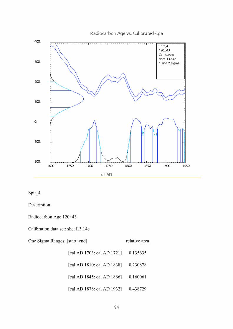
94
Spit_4
Description
Radiocarbon Age 120±43
Calibration data set: shcal13.14c
One Sigma Ranges: [start: end] relative area
[cal AD 1703: cal AD 1721] 0,135635
[cal AD 1810: cal AD 1838] 0,230878
[cal AD 1845: cal AD 1866] 0,160061
[cal AD 1878: cal AD 1932] 0,438729

95
[cal AD 1938: cal AD 1944] 0,034697
Two Sigma Ranges: [start: end] relative area
[cal AD 1679: cal AD 1732] 0,212637
[cal AD 1801: cal AD 1949*] 0,787363
Ranges marked with a * are suspect due to impingement on the end of the calibration data set

96
The XRF Results
wt %
SiO2
Al2O3
Fe2O3
MnO
MgO
CaO
Na2O
K2O
TiO2
P2O5
Cr2O3
NiO
TOTAL
LOI
Q1 62.41
16 9.28 0.1 7.84 1.33
0.46 2.11
0.74 0.13 0.05 0.02
100.46 8.15
Q2 61.27
15.72 14.84 0.28 4.09 1.82
0.36 0.94
1.12 0.47 0.18 0.05
101.12 7.78
Q3 59.57
13.51 11.36 0.14 11.88
2.38
0.33 0.59
0.63 0.13 0.05 0.02
100.6 5.13
Q4 61.53
14.82 10.2 0.15 8.51 1.74
0.34 1.85
0.71 0.19 0.04 0.02
100.1 5.75