Embed Size (px)
Citation preview
ARCHAEOLOGICAL IhVENTOXY OF
THE IVUJIVIK ATWOBT DEVELOPMENT m A ,
MORTHEW QUZBEC
VOLUME 1; TEXT A?.? APPENDICES
Presented to the
Makivik Corporation
by
Amenatech inc.
345, Industrial Boulevard
Sherbrooke, Quebec
J1L 1x8
January, 1985
TABLE OF COATWTS
FIGURES
TABLES
APPENDICES
SUMMARY
ADKNOWLEDGEMENTS
1.0 INTRODUCTION
2.0 RESEARCH OBJECTIVES AND ORIENTATIONS
3.0 DESCRIPTION OF THE STUDY AREA
3.1 Location and Physical Setting
3.2 Flora and Fauna
3.3 Paleoenvironment
3.4 Previous Archaeological Research
4.0 SURVEY PROCEDURES
4.1 Survey Limits
4.2 Sampling Techniques
4.3 Data Registration
4.4 Site Plans and Maps
4.5 Community Consultatton
5.0 SURVEY RESULTS
5.1 Prehistoric Sites
5.1 . I Meeus Site (KcFr-4)
iii
v i i i
5.1.2 Mungiok Site (KcFr-7)
5.1.3 Pita Site (KcFr-51,
5.1.4 Ohituk Site (KcFr-3)'
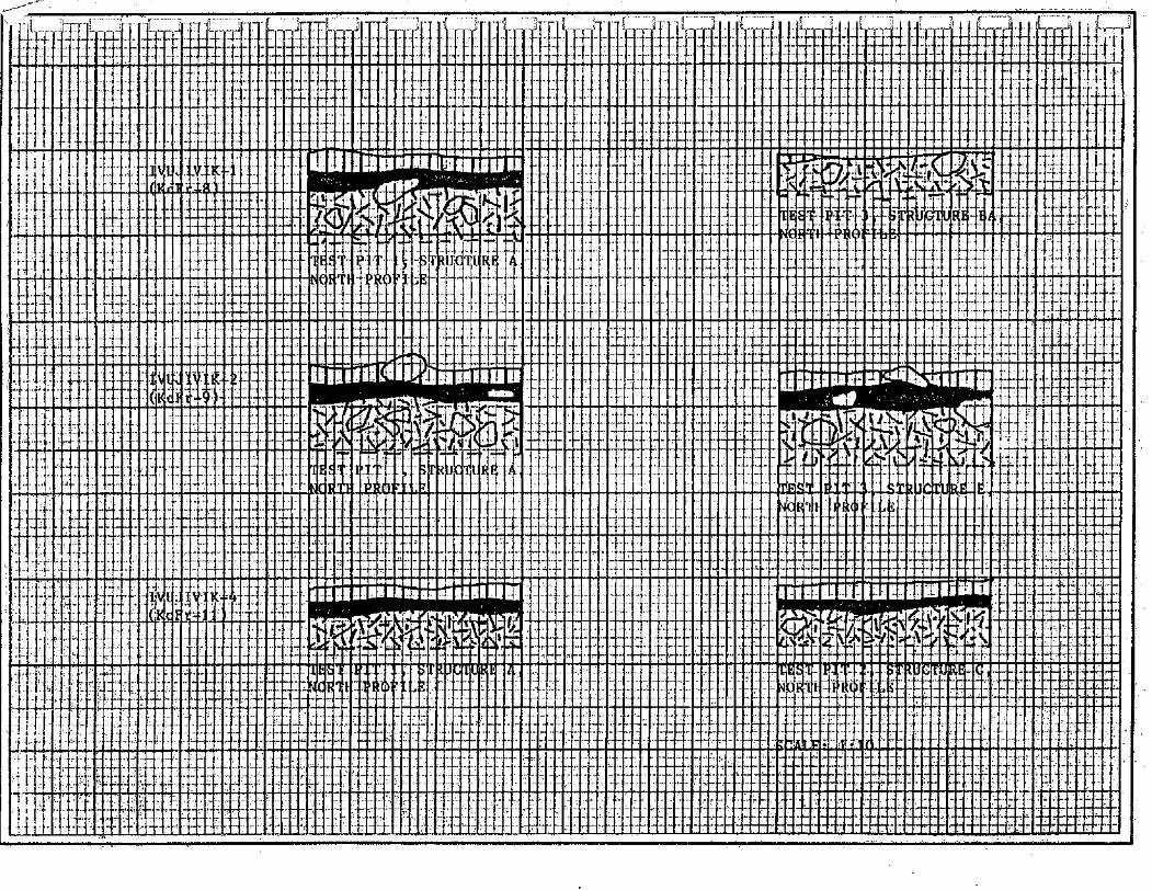
5.1.5 Ivujivik-1 (KcFr-8)
5.1.6 Ivujivik-2 (KcFr-9)
5.1.7 Ivujivik-3 (KcFr-10)
5.1.8 Ivujivik-4 (KcFr-11)
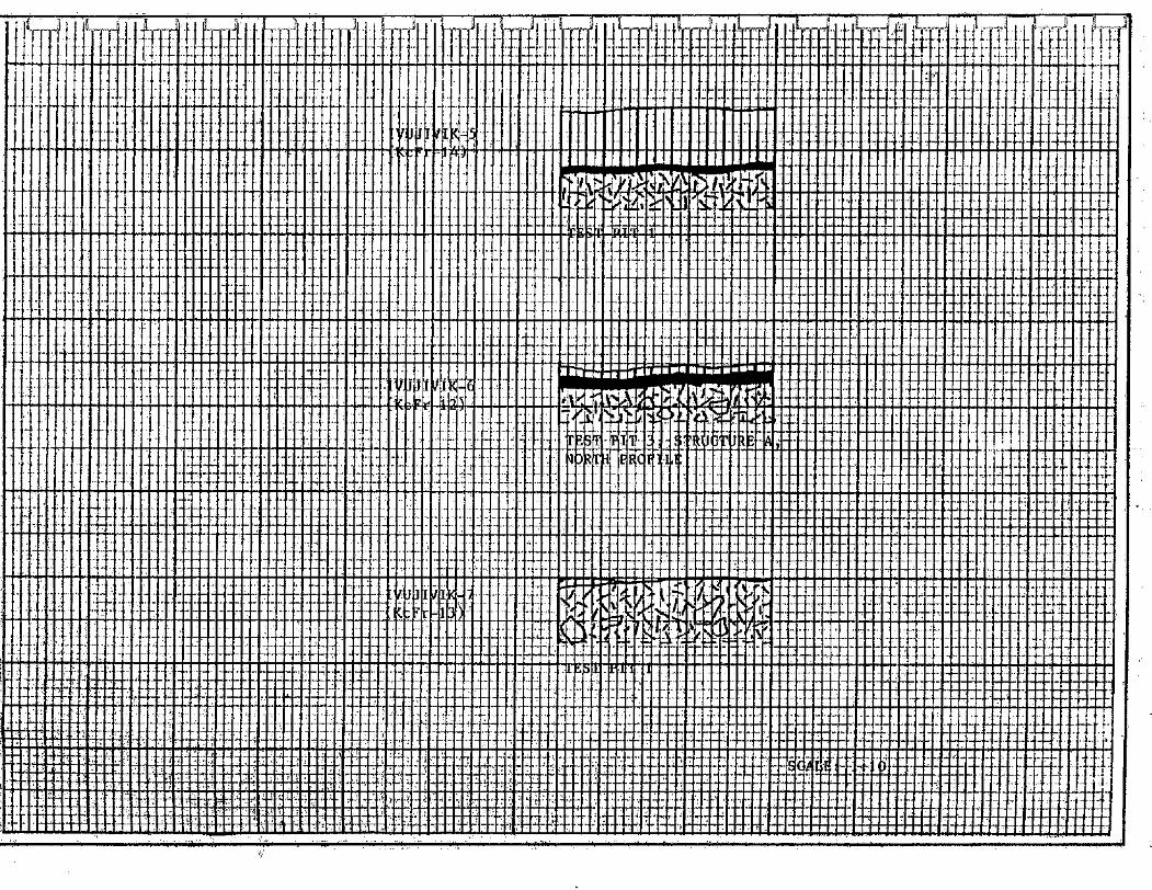
5.1.9 Ivujivik-5 (KcFr-14)
5.1.10 Ivujivik-6 (KcFr-12)
5.1.11 Ivujivik-7 (KcFr-13)
5.2 Contemporary Activity Areas
5.3 Impact Mitigation
6.0 DISCUSSION
7.0 RECOMMENDATIONS
8.0 PERSONNEL
g 9.0 BIBLIOGRAPHY
Figure 1.
Figure 2.
Figure 3. '
Figure 4.
Location of Ivujivik, Northern Quebec
Location of the Survey Area
Survey Limits and Archaeological Site
Locations, Ivujivik, Northern Quebec
Distribution of Test Pits, Ivujivik-5 (KcFr-
14)
Table 1.
Table 2.
Table 3.
Table 4.
Table 5.
Table 6.
Table 7.
Table 8.
Table 9.
TABLES
Location of Prehistoric Sites Inventoried, 19
Ivujivik, Northern Quebec
Summary of Habitation Structures Identified 2 5
in Area C, the Meeus Site (KcFr-4)
Lithic Specimens Collected in the Meeus Site 29
(KcFr-4)
Summary of Habitation Structures Identified 3 3
in the Mungiok Site (KcFr-7)
Lithic Specimens Collected in the Mungiok 37
Site (KcFr-7)
Summary of Habitation Structures Identified 41
in the Pita site (KcFr-5)
Lithic Specimens Collected in the Pita Site 43
(KcFr-5)
Summary of Habitation Structures Identified 48
in the Ohituk Site (KcFr-3)
Summary of Rabitation Structures Identified 5 1
in the Ivujivik-1 Site (KcFr-8)
Table 10. Summary of Secondary Cultural Features 56
Observed in the Ivujivik-1 Site (KcFr-8)
Table 11. Lithic Specimens Collected in the Ivujivik-1 59
Site (KcFr-8)
Table 12. Summary of Habitation Structures Identified 6 2
in the Ivujivik-2 Site (KcFr-9)
Table 13. Summary of Habitation Structures Identified 67
in the Ivujivik-3 Site (KcFr-10)
Table 14.
Table 15.
Summary of Habitation Structures Identified 70
in the Ivujivik-4 Site (KcFr-11)
Summary of Contemporary Activity Areas 79
Observed in the Vicinity of the Village of
Ivu jivik
APPENDICES
Appendix A List of Photographs
Appendix B
Appendix C'
Appendix D
Appendix E
Appendix F
Appendix G
Appendix H
Appendix I
Appendix J
Catalogue of Lithic Specimens
Archaeological Potential Zones and Sites,
Ivujivik, Northern Quebec
Representative Stratigraphic Profiles of
Prehistoric Sites Inventoried, Ivujivik,
Northern Quebec
Site Plan: Meeus Site (KcFr-4)
Site Plan: Mungiok Site (KcFr-7)
Site Plan: Pita Site (KcFr-5), Ohituk Site
(KcFr-3)
Site Plan: Ivujivik-1 Site (KcFr-8)
Site Plan: Ivujivik-2 Site (KcFr-9),
Ivujivik-3 (KcFr-10)
Site Plan: Ivujivik-4 Site (KcFr-ll),
Ivu jivik-6 (KcFr-12)
vii
The present report details the results of an
archaeological survey conducted in the environs of the Inuit
village of Ivujivik, Northern Quebec. This survey focused on the
verification of previously determined archaeological potential
zones occurring within the airport development area of the
village. Several prehistoric sites earlier reported in the area
were also evaluated.
The survey resulted in the identification of seven (7)
prehistoric habitation sites and three ( 3 ) contemporary activity
areas. Of the sites, one (1) is interpreted as Pre-Dorset, two ( 2 )
as Dorset and two ( 2 ) as multiple occupations. Paleoeskimo
occupations of undetermined cultural affiliation are suggested for
the other two ( 2 ) sites.
The survey also resulted in the more precise definition
of three (3) Pre-Dorset and one (1) Dorset sites previously
recorded in the area. Habitation structures identified in these
sites as well as in those newly discovered include semi-
subterranean dwellings and mid-passage tent rings.
The implementation in the field of protective measures
eliminated the necessity of immediate salvage excavation of four
( 4 ) sites threatened by the construction of the airport. It is
recommended, however, that forthcoming surveys in Northern Quebec
airport development areas be undertaken well in advance of
scheduled construction activities. It is further recommended that
the Inuit communities concerned by this development project
participate in these surveys.
viii
Transportation and field logistics for the archaeological
survey of the Ivujivik airport development area were arranged by
the Makivik Corporation. Inuit field assistants for the survey
were suggested by Ms. Lorraine Brookes, Director of the Makivik
Research Department, and Mr. William Kemp, the Makivik manager of
the survey.
Mr. Edward Mesher of Kuujjuaq served as field assistant
between the 7 and 10 August but, due to a prior commitment, was
unable to complete the survey. Mr. Mesher was replaced by Mr.
Jacques Brouard, the on-site representative of the ministere des
Transports du QuBbec, who kindly volunteered his services as
archaeological assistant between the 10 and 19 August. Mr. Brouard
also placed at our disposal the airport construction plans, thus
facilitating the more precise orientation of the survey activities
in terms of on-going and projected construction activities.
The survey and measures for the mitigation of
construction impacts on prehistoric sites located in the airport
development area were carried out through the consent of the
Municipal Council of Ivujivik. The mitigation measures were
implemented on the authority of Mr. Clement Tremblay, Office of
the Deputy Minister, ministere des Transports du Qugbec, in
collaboration with the council. Meetings with the council were
chaired by Mr. Adamie Kolinga, Secretary-Treasurer of the
municipality. Mr. Kolinga also acted as interpreter during these
meetings.
Accomodations during our study in Ivujivik were provided
by Mrs. Mary Tarkik. The warm hospitality of Mrs. Tarkik and her
family, as well as that of the community at large, contributed
directly to the survey results.
We gratefully acknowledge the contributions of each of
these individuals and organizations to the successful completion
of the research undertaken.
1 .o INTRODUCTION
The present report describes the results of an
archaeological survey conducted between August 7-19, 1984, in the
vicinity of the village of Ivujivik, Northern Quebec. This survey
represents the second phase of archaeological research undertaken
in the municipality within the context of the environmental impact
studies engendered by the Northern Quebec Airport Development
project. The first phase involved the theoretical study of the
archaeological potential of the area of projected airport
construction and related works. Both of these phases, financed by
the ministsre des Transports du Qugbec, were carried out by
Amsnatech Inc. under contract with the Makivik Corporation.
The report comprises two (2) volumes. Volume 1 presents
the research objectives, the survey area and procedures. The
survey results, including descriptions of the prehistoric sites
and contemporary activity areas inventoried and impact mitigation
measures, are then summarized. This summary is followed by
preliminary interpretations of the site data and several
recommendations concerning future archaeological research in the
area. Volume 1 is completed by a list of the individuals involved
in the project, a bibliography of references cited and a series of
appendices. The appendices include a list of photographs taken
during the survey, a catalogue of lithic specimens recovered from
each site and preliminary plans of the sites surveyed.
Volume 2 consists of a site photograph appendix. No
attempt has been made to illustrate the totality of the data
photographed at each site. Instead, the photographs presented
provide a representative sample of the habitation structures and
cultural features identified in the sites.
2.0 BBSKARCE OBJECTIVES dFlD ORTENTATIONS
The survey was organized in terms of the results of the
archaeological potential study prepared for the airport
development area of the municipality of Ivujivik (Amhatech,
1984). This study indicated that a number of probable
archaeological site localities would be affected by construction
activities. It was also noted that several earlier recorded
prehistoric sites occurred within the development area.
The immediate objectives of the survey were, then, three-
fold: 1. verification of the theoretically-determined
archaeological potential zones; 2. evaluation of the previously
reported sites and; 3. assessment of the regional and local
archaeological importance of cultural heritage resources located
in the area defined. The ultimate objective of the research was
the establishment of measures for the mitigation of construction
impacts on these resources.
Survey activities concentrated, firstly, on zones of high
and moderate archaeological potential and on known sites located
in or close to projected construction works in the airport
development area (i.e., runway extensions, borrow-pits, quarries,
access roads, etc.). Secondly, zones of similar potential adjacent
to this area were inventoried. Zones of low or nu1 archaeological
potential were concomitantly examined. The inventory of these
latter zones, comprising the overwhelming bulk of the area
surveyed, was less systematic then that of the more probable site
localities. The data collected, however, tends to confirm the lack
of archaeological potential pre-determined for these zones.
3.0 DESCRIPTION OF TEE STUDY AREA
3.1 Location and Physical Setting
The study area comprises the immediate environs of the
village of Ivujivik, northwestern Ungava, in Ungava County,
Northern Quebec. The village is located on the extreme
northeastern coast of Hudson Bay, at (Fig. 1). It
is situated on a small Peninsula on Digges Sound, roughly 40 km
southwest of Cape Wolstenholme, the western entrance to Hudson
Strait (Fig. 2).
The area occurs in the western section of the Cape Smith
Fold Belt in the Churchill Province of the Canadian Shield
(Stockwell et al., 1972). The fold belt, characterized by
structural unconformities, corresponds to the Sugluk Plateau
Division of the James physiographic region (Bostock, 1972). In the
study area, this plateau is of low, undulating relief, the rounded
bedrock hills forming the Ivujivik peninsula rarely exceeding
100 m.a.s.1. in altitude. Marine deposits associated with the
Tyrrell Sea transgression are scattered throughout the peninsula.
Glacial tills are thin and discontinuous.
The study area is situated in the Polar Tundra Climatic
zone, a zone dominated by the Arctic Air Mass (Environnernent
Canada, 1982, D-2). The annual mean temperature is -5.0°C, with a
yearly average of twenty (20) frost-free days. Annual
precipitation is in excess of 40 cm, half of which occurs as snow.
Northwesterly and southerly winds prevail during summer and winter
respectively.
- PROJET TITRE - Amenatech inc. A r c h e o l o g i c a l i n v e n t o r y o f t h e L o c a t i o n o f I v u j i v i k , N o r t h e r n D , ~ , ~ , ~ ~ orninoprmcnt rt envsronncmat I ~ u j i v i k a i r p o r t deve lopmen t a rea, Quebec au ~ r o u ~ t - c o n s c i f S.M ~ n c N o r t h e r n Quebec
I t ESSINE PAR A P P R ~ U V ~ P b R DATE
R.W. I a n B a d g l e y J a n u a r y 1985 I I
CHELLE R ~ F E R E N ~ ~ 1:5 800 000 56-550 FEU'LLE F i g u r e 1
3.2 Flora and Fauna
The vegetation of the area consists of a moss-lichen
tundra mixed with herbaceous and shrubby elements (Richard,
1981: 18-23). Moss and lichens predominate in exposed, dry zones
while Cyperaceae and Gramineae occupy less well-drained,
relatively protected surface deposits. The principal shrubs
include dwarf birch, willow and alder. Sphagnum colonies of
limited extent occur in wet zones.
The fauna of the region is characteristically "arctic" in
association. Marine mammals frequenting the region in relative
abundance include ringed seal (Phoca hispida), bearded seal
(Erignathus barbatus), greenland seal (Phoca groenlandicus),
beluga (Delphinapterus leucas) and walrus (Odobenus rosmarus)
(Science Advisory Board of the Northwest Territories, 1980.
Terrestrial mammals include, among others, polar bear (m maritimus), fox (Alopex lagopus), mink (Mustela vison) and arctic
hare (Lepus arcticus). Caribou (Rangifer tarandus), frequenting
the area until the early 20th century, are now generally
restricted to more southerly and easterly regions (Audet, 1979;
Environnement Canada, 1982, G-1).
As listed by Vezinet (1982:73, Table 3 ) , several
varieties of ducks, loons, geese and gulls occur in the region.
The black guillemot (Cepphus grylle) is particularly abundant.
Salvelinus species, including Arctic char and Quebec red char,
represent the major fish populations in the region (McCart and
Beste, 1979; Vezinet, 1982). Clams, several varieties of mussels
and krill are also numerous.
3.3 Paleoenvironment
The final Wisconsin deglaciation began in the Hudson
Strait region around 9000 B.P. and, by about 8000 B.P., the
Laurentian ice had retreated along the entire coastline of the
Ungava Peninsula (Prest, 1972: Figure XII-15). The glaciers
continued to recede and, by 6500 B.P., the majority of the
peninsula had been deglaciated. Remnant ice in the interior had
disappeared 500 years latter.
The deglaciation of western Ungava was accompanied by the
Tyrrell Sea marine transgression. This transgression, dated to
between 8000-7000 B.P., extended to variable distances inland
along the perimetre of Hudson and James bays (c.f., Hillaire-
Marcel, 1979, Figure 41). In northeastern Hudson Bay, however,
these marine waters were generally restricted to the present
coastal zone, attaining a maximum limit of 167 m.a.s.1. at Cape
Wolstenholme (Hillaire-Marcel, 1979:98). The Tyrrell Sea retreated
in correspondence with isostatic rebound and, by 3000 B.P., the
northwestern section of the Ungava Peninsula had fully emerged.
The present Hudson Bay littoral in this area developed following
this date.
According to Richard (1981, intra vida), the coastal zone
of the northern Ungava Peninsula was probably colonized by a
sparse herbaceous tundra vegetation sometime shortly after
8000 B.P. This tundra, expanding into upland areas coincidental
with the deglaciation of the interior, was replaced by a shrub
tundra around 6200-5500 B.P. This more luxuriant vegetation,
associated with a general warming trend culminating in the Little
Climatic Optimum, was succeeded by a second herbaceous tundra
approximately 1000 years later. As suggested by available
palynological evidence, this latter tundra has undergone little
change during the past 3500 years.
3.4 Previous Archaeological Research
Previous archaeological research activities in extreme
northwestern Ungava have varied in scope as well as in character.
The earliest of these activites are represented by Leechman's 1936
excavations in two (2) clusters of Dorset semi-subterranean
dwellings located on the Nuvuk Islands (Leechman, 1943). These
pioneering efforts, clarifying the extent of the then newly-
defined Dorset culture, were followed by Taylor's 1958 and 1959
surveys on eastern Manse1 Island and in the vicinity of Ivujivik
(Taylor, 1959, 1960). These surveys also included limited and
extensive excavation of both Pre-Dorset and Dorset sites. More
recently, an additional Dorset site and five (5) Thule sites were
identified by Plumet during a helicopter fly-over of the Nuvuk and
Digges Islands in 1979 (Plumet and Badgley, 1980).
Of particular importance to the present study are the six
(6) archaeological sites reported on the Ivujivik peninsula. These
sites include the Pre-Dorset Meeus, Mungiok and Pita sites and the
Dorset Ohituk and Eeteevianee sites. The sixth site, a small
quartz quarry, is also of possible Dorset affiliation.
As illustrated by Figure 3, the three ( 3 ) Pre-Dorset
sites and Ohituk are located in the northern section of the
airport development area of the municipality. Although the exact
location of the prehistoric quarry is unknown, available data
indicates that this site also occurs in this section of the
development area. The second Dorset site, Eeteevianee, is situated
immediately west of this area.
Research activities in the Pre-Dorset sites involved
surface collecting and the excavation of test pits, the number of
pits varying according to the site (c.f., Taylor, 1962). Neither
habitation structures nor other cultural features were observed in
the Mungiok or Pita sites. In the Meeus site, however, two ( 2 )
slight depressions suggested habitations. These dwellings were
identified and excavated by a local Inuit resident.
The two (2) Dorset sites, only briefly mentioned in
Taylor (1959, 1960, 1968) were subjected to controlled
excavations. These excavations centred, in the Eeteevianee site,
on a semi-subterranean dwelling and, in the Ohituk site, on a
raised gravel beach ridge; no habitation structures were observed
in the latter case.
All three (3) of the Pre-Dorset sites yielded significant
lithic collections. With the exception of several decayed bone
fragments recovered in the Meeus sites, faunal and other organic
materials were lacking in these sites. Although the data from the
Dorset sites are unpublished, these sites appear to have produced
organic remains as well as lithic collections.
The results of the research activities carried out in the
vicinity of Ivujivik suggest that the initial Pre-Dorset
occupation of northwestern Ungava dates to the middle of the
second millenium B.C. (Taylor, 1962:90). Additionally, relatively
intensive and (probably) continuous occupation of the region by
Pre-Dorset and Dorset groups appears to be indicated. The second
of these cultures may have persisted in this region until the lfth
or 12th century, if not later.
As Thule sites in northern Quebec have received little
archaeological attention, neither the chronology nor the nature of
these Neoeskimo occupations in this region have been determined.
However, a 12th to 14th century date may be speculated for the
movement of Thule groups into the region. These late prehistoric
populations represent the ancestors of the Inuit historically
encountered in northern Quebec.
4.0 SURVEY PROCEDURES
4.1 Survey Limits
Survey activities were restricted to the Ivujivik
peninsula. These activities were carried out, firstly, in the
airport development area of the municipality and, secondly, in the
coastal zone adjacent to this area.
As defined in the earlier potential study, the airport
development area measures approximately 1 km in maximum width and
roughly 3.2 km in maximum length (Appendix C). This area, situated
in the central part of the peninsula, comprises the existing
airstrips, the projected runway extensions and airport facilities,
the proposed water intake point, access roads, and suggested
gravel pit and quarry sites.
Four (4) of the six (6) archaeological sites previously
reported in the vicinity of Ivujivik are also located in this
area.
The coastal zone surveyed extends from the bottom of
Ivujivik Harbour to the middle of the northeastern shore of Nuvuk
Harbour, an overall distance of about 7.5 km (Fig. 3). The
northeastern half of a narrow valley crossing the foot of the
peninsula was also surveyed.
4.2 Sampling Techniques
All localities inventoried were subjected to an extensive
visual inspection involving surface collecting activities. In the
14
case of high and derate potential zones and of confirmed
archaeological sites, these preliminary efforts were followed by
test pitting. The number and location of the test pits excavated
varied according to the extent of the zone or site, surface
collecting results and initial sampling productivity. However, as
sampling was directed toward the verification of archaeological
potential and to the recovery of temporally-sensitive cultural
data, testing was non-random in character. Accordingly, the
majority of the test pits were excavated either in or close to
presumed or identified habitation structures.
Standard test pits, oriented north-south, measured 50 cm
x 5 0 cm. In the Meeus site, however, sampling included the
excavation of four ( 4 ) 2 m x 2 m test zones. The greater part of
this site lies directly in the path of the runway extension and,
consequently, shall be destroyed by the airport construction.
These limited test excavations, then, were deemed appropriate to
the more adequate assessment of the site's importance and to the
determination of possible mitigation measures. The results of this
sampling proving sufficient to this assessment, two ( 2 ) additional
test zones plotted in the site were unexcavated. All of the 4 m2
test zones were located in presumed habitation structures.
4.3 Data Registration
Cultural materials recovered on the surface were
collectively registered according to site, no effort being made to
precisely locate these materials within the respective sites.
Alternately, materials produced by the test pits were recorded
according to test pit and, when necessary, habitation structure
designation. Habitation structures were identified by alphabetic
letters and the test pits by arabic numerals. Test excavations in
the Meeus site were assigned roman numerals.
Stratigraphic profiles of the north walls and, in one
case, of the east wall of the test pits and zones were recorded to
a 1:10 scale. Representative profiles, all habitation structures
and secondary cultural features as well as site overviews were
photographed in black and white and in colour using a 35 mm Pentax
Spotmatic and a Vivitar 35 CA cameras. The mechanical failure of a
third camera prohibited slide photography of the sites.
4.4 Site Plans and Maps
Scaled plans illustrating the principal physical
characteristics of the sites and the location of test pits,
habitation structures and other cultural features were prepared
for all but one of the sites using a Geotec pocket transit and 60-
'li meter survey chain. The exception, the Ivujivik-7 site (KcFr-13),
consists of thin gravel deposits discontinuously scattered across
an extensive bedrock surface of low relief. This site, registered d on the basis of several small chert flakes, is lacking in
1 identifiable occupational features as well as in definable limits.
In addition to the site plans, a detailed map of the
Meeus site was prepared using a Sokkisha 20 C model theodolite.
This mapping, including topographic transects, was deemed '-?
appropriate due to the imminent destruction of the bulk of the
site. The map was produced, then, in the interest of providing an
accurate record of the major characteristics of this extensive
prehistoric site.
4.5 Community Consultation
The Municipal Council of Ivujivik was met with formally
on two (2) separate occasions during the course of the survey.
Both of these meetings were chaired by Mr. Adamie Kolinga, the
Secretary-Treasurer of the municipality, who also acted as
interpreter.
The first of these meetings, held August 7, was in
request of the permission of the council to conduct the proposed
research. During this meeting, discussion focused on the
explanation of the extent, objectives and activities of the survey
planned. Information concerning archaeological sites known to the
council members was also solicited at this time.
The second meeting, held August 17, centred on a summary
description of survey results and, more particularly, on measures
proposed for the mitigation of impacts on four (4) prehistoric
sites threatened by airport construction. This meeting involved
representatives of the ministsre des Transports du Qugbec, the
municipal council and the survey director. The proposed mitigation
measures concerned the elimination of a projected borrow-pit and
the restriction of vehicular movement in archaeologically
sensitive localities. These measures, approved by the municipal
council, were implemented by the ministsre des Transports du
Qugbec on the authority of Mr. Clgment Tremblay, Office of the
Deputy Minister of the ministry.
5.0 SWWY RESULTS
5.1 Prehistoric Sites
The archaeological survey of the environs of Ivujivik
resulted in the inventory of eleven (11) prehistoric sites, seven
(7) of which were previously unreported (Fig. 3). Of these sites,
four (4) represent Pre-Dorset occupations, three ( 3 ) are Dorset
settlements and two (2) are of multiple cultural affiliation
(Table 1). Of the latter, one is interpreted as containing Pre-
Dorset, Dorset and historic Inuit components and the other, Pre-
Dorset, Dorset and, possibly, Thule components. The cultural
affiliation of the remaining two (2) sites, each of which was
identified on the basis of several chert flakes, is undetermined.
However, the lithic raw material and the altitudes of these sites
suggest either Pre-Dorset or Dorset occupations.
Of the seven (7) sites discovered, one (1) occurs in a
zone of high potential situated in the airport development area
and four (4) on the periphery of this area (Appendix C). The other
two (2) sites are located on land adjacent to the development
area, close to the southeastern extremity of Ivujivik Harbour.
The four (4) previously registered sites inventoried
comprise the Pre-Dorset Meeus, Mungiok and Pita sites and the
Dorset Ohituk site. The published reports and site archives
consulted during the preparation of the archaeological potential
study of the Ivujivik airport development area suggested that only
the Pre-Dorset sites were located in this area. However, as
indicated by the survey, the Dorset Ohituk site also occurs in the
development area. Additionally, clarification of exact site
locations resulting from the survey explains the situation of the
Meeus and Mungiok sites in zones theoretically determined as being
of moderate or low archaeological potential respectively.
The Eeteevianee site, the second Dorset settlement
reported in the vicinity of Ivujivik, is situated a short distance
west of the development area. As observed in the field,
excavations in this site were considerably more extensive than had
been anticipated from the study of published documents. These
excavations, indicated by a large and several smaller depressions
partially refilled with boulders and cobbles, are estimated to
cover a total area in excess of 150 m2. Due to its location and
the extent of excavation, this site was only visually inspected,
the brief surface collecting carried out producing no cultural
materials. The Eeteevianee site is consequently excluded from the
following site descriptions. However, in order to provide a more
accurate record of its location than is presently available, this
site is listed in Table 1.
Finally, as the presumed Dorset quarry noted by Taylor
(1960) may correspond to any one of a number of quartz outcrops
observed in the northern section of the development area, the
location of this site remains unknown. With the exception of a
small quartz quarrying station situated in the Meeus site, none of
the other observed quartz outcrops yielded any unequivocable
evidence of cultural use.
TABLE 1: LOCATION OF PREHISTORSC SITES INVENTORIED, IWJIVSK, NORTHERN QUEBEC.
SITE BORDEN GEOGRAPHIC U.T.M. MAP ALTITUDE DISTANCE/ CODE CO-ORDINATES (m.a.s.1.) SHORELINE (m)
Meeus KcFr-4 N: 35K/5 33-46 100 W:
Mungiok KcFr-7 N: 35K15 41-51 150 W:
Pita KcFr-5 N: 35K/5 37-38 300 W:
Ohituk KcFr-3 N: 62'25'24" 35K/5 16-23 100 W:
Eeteevianee KcFr-1 N: 35K/5 14 W'1
Ivuj ivik-3 KcFr-10 3510'5 22-32 80
CULTURAL AFFILIATION
PRE-DORSET
PRE-DORSET
PRE-DORSET
DORSET
DORSET
PRE-DORSET, DORSET AND HISTORIC INUIT
PRE-DORSET, DORSET AND (POSSIBLY) THULE
DORSET
PRE-DORSET
UNDETERMINED PALEOESKTMO
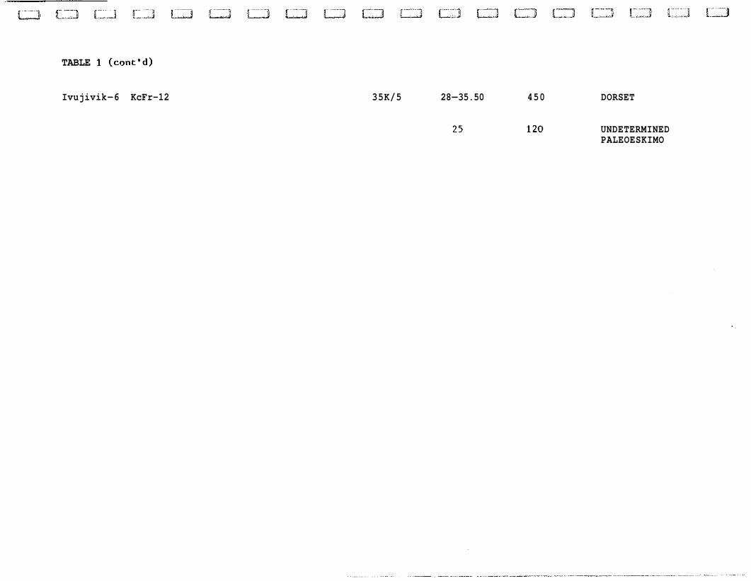
TABLE 1 (cont'd)
Ivujivik-6 KcFr-12 35K/5 28-35.50 450 DORSET
UNDETERMINED PALEOESKIMO
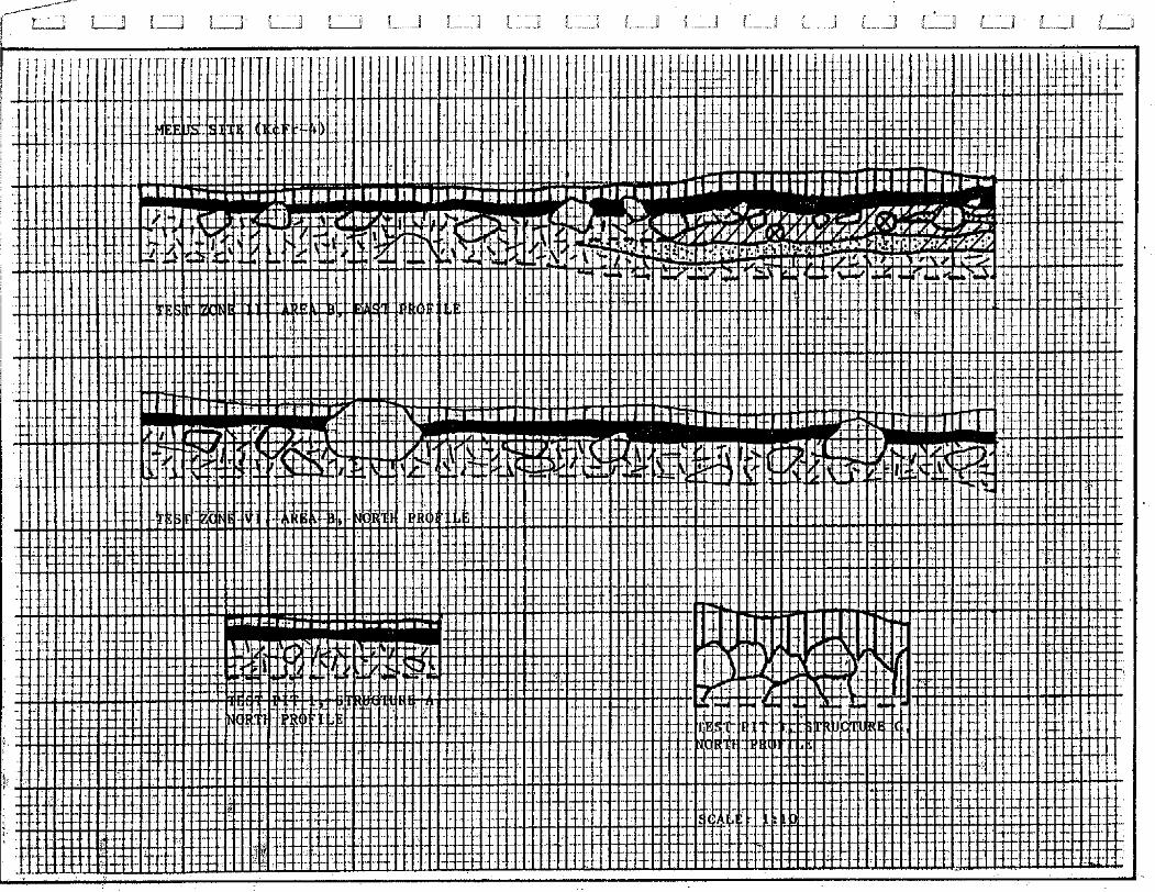
5.1.1 Meeus Site (KcFr-4)
Cultural Affiliation: Pre-Dorset
Location
Geographic Co-ordinates:
U.T.M.: MAP: 35K/5 (1:50 000)
Altitude (m.a.s.1.): 32 - 46 Distance/shoreline (m) : 100
General Description
The Meeus site is situated approximately 360 m northwest
of the village of Ivujivik (Fig. 3). The greater part of the site
occupies a series of raised gravel beaches and deposits located on
the eastern flank of a low bedrock hill. These beaches are
bordered, to the north, by an exposed bedrock surface and, to the
northeast, by an abrupt bedrock summit (Appendix E). Bedrock
sloping eastward and southward toward Ivujivik Harbour and the
village respectively delimit the southern extremity of the site.
The Meeus site was originally defined by lithic materials
scattered across a "...600-by 1800-foot oval..." area (ca. - 560 m x 185 m) oriented northeast-southwest (Taylor, 1962:80). However, as
defined during the present survey, the site comprises three ( 3 )
separate areas measuring, in overall dimensions, approximately
260 m east-west by about 210 north-south. These discrepancies may
be explained, firstly, by the construction of the airport garage
which, located roughly 200 m southwest of the site, has probably
eradicated a significant portion of the site. Secondly, it is
possible that the occupational data contained in the southern
extremity of the site were not recognized as such at the time of
its definition. The approximate 45-metre length of this extremity,
equivalent to the difference between the earlier and present
north-south measurements of the site, tends to support this
speculation.
The three (3) areas defined in the Meeus site are
estimated to total more than 30 000 m2. Area A, the most westerly
section of the site, is composed of a relatively flat gravel
deposit measuring roughly 70 m by 120 m. Area B, separated from
the former by a bedrock surface of low relief, consists of a
relatively extensive series of well-defined, south-facing gravel
beach ridges. The north-south axis of this area is approximately
120 m in length and the east-west axis, about 130 m. These beaches
extend into the northern section of Area C. The bulk of this third
area is formed, however, by a level gravel deposit interspersed
with low bedrock outcrops. A boulder field of limited extent occur
in the southern section of this area. Area C measures slightly
more tha 90 m in maximum length by 60 m in maximum width.
Vegetation is generally sparse, consisting mainly of low
mosses, lichens and short grasses. Denser patches of vegetation,
some with dwarf birch and willow, are scattered across the site. A
relatively thick sphagnum layer discontinuously covers the boulder
field. Several blow-outs of variable extent occur throughout the
site.
Sampling and Stratigraphy
A total of six (6) 2 m x 2 m test zones were plotted in
possible habitation structures located in Area B of the site. Of
these zones, four (4) were completely excavated (i.e., Zones 11,
111, IV and VI). In addition, single test pits were excavated in
each of five (5) habitation structures situated in Area C. Two (2)
of these structures (designated A and B) occur in the boulder
field and two (2) others (i.e., Structures G and I), on the gravel
deposit in the central section of the area. The fifth structure
sampled, Structure J, is located on the western edge of the area,
on a bedrock ledge covered by a thin mantel of gravel and sand.
Soil stratigraphics revealed in the test pits and zones
excavated in the gravels in both of the sampled areas are
basically similar in composition. These stratigraphies are
composed of yellowish-brown, fine to medium coarse sandy gravels
overlain by a thin layer of dark brown organic soil (Appendix D).
These soils, lacking in Structure 3 as well as in the boulder
field, vary in thickness from less than 1 to roughly 3 cm.
Excluding Test Zone 11, no definable cultural layers or horizons
were observed in any of the test pit or zone profiles.
As illustrated in Appendix D, the organic soil in the
southern section of the east wall profile in Test Zone I1 is
separated from the underlying gravel by a black lense of charcoal
and burnt grease intermixed with sand (see Photo 4). This lense,
approximately 70 cm in length by 7 cm in maximum thickness, is
interpreted as a hearth. This interpretation is further suggested
by decayed and preserved bone fragments both in and surrounding
the excavated portion of the lense. The hearth and associated
activity area are more fully discussed in the following pages.
Habitation Structures
A total of twelve ( 1 2 ) habitation structures were
identified in the site. Eleven (11) of these structures are
located in Area C and one ( I ) , a recent tent ring, in Area A.
Also, an undetermined number of possible habitations are suggested
by the denser patches of vegetation, occasionally associated with
rocks, scattered across Area B. The four ( 4 ) test zones excavated
in this area were located in such patches. However, with the
possible exception of Test Zone 11, the data recovered from these
tests are insufficient to the definition of habitations in these
zones.
A disturbed, slight depression in a small gravel deposit
located on the bedrock separating Areas A and B is tentatively
interpreted as an excavated dwelling. This excavation, apparently
of recent origin, is roughly rectangular in shape, measuring
approximately 2 m by 1.5 m by 10 cm in depth. As the only two (2)
dwellings identified and excavated in the site in 1 9 5 8 (c.f.
Taylor, 1 9 6 2 : 8 0 ) occured in the area presumed to have been
destroyed by the construction of the garage, a third, locally
excavated habitation may be suggested.
The tent ring observed in Area A is composed of a
circular alignment of evenly-spaced rocks measuring 4 m in
diametre. Cultural materials associated with this structure
include several small pieces of canvas, empty cartridges and
cartridge boxes.
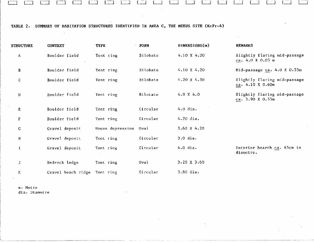
/ TABLE 2. SUMMARY OF HABITATION STRUCTURES IDENTIFIED IN AREA C, THE MEEUS SITE (KcFr-4)
I
1 STRUCTURE CONTEXT TYPE FORM DIMENSIONS(m) REMARKS
A Boulder field Tent ring Bilobate 4.10 X 4.20 Slightly flaring mid-passage ca. 4.0 X 0.05 m -
B Boulder field Tent ring Bilobate
C Boulder field Tent ring Bilobate
D Boulder field Tent ring Bilotate
E Boulder field Tent ring Circular
F Boulder field Tent ring Circular
G Gravel deposit House depression Oval
H Gravel deposit Tent ring Circular
I Gravel deposit Tent ring Circular
J Bedrock ledge Tent ring Ova 1
K Gravel beach ridge Tent ring Circular
4.0 dia.
4.20 dia.
3.60 X 4.20
3.0 dia.
4.0 dia.
3.20 X 3.60
3.80 dia.
Slightly flaring mid-passage ca. 4.10 X 0.60111 -
Slightly flaring mid-passage ca. 3.90 X 0.5511 -
Interior heart-h E. 65cm in diametre.
m= Metre dia= Diametre
The eleven ( 1 1 ) structures identified in Area C comprise
ten ( 1 0 ) tent rings and one ( 1 ) dwelling depression. Four ( 4 ) of
the tent rings are slightly bilobate in form, containing central
mid-passage features. These structures are of relatively uniform
overall dimensions, varying between 4.00 m and 4.30 m in length
and 4 .OO and 4.20 m in width (Table 2 ) . The mid-passage features
are defined by parallel rows of rocks bisecting the structures
into two ( 2 ) equal parts. These features, all of which are
oriented east-west, vary between 50 and 60 cm in average width.
Entrances to the structures, suggested by slight flaring of the
mid-passages, face eastward towards Ivujivik Harbour.
Of the other six ( 6 ) tent rings, five ( 5 ) are circular
and one (1 ) is oval in shape. The circular structures vary from
3.00 to 4.20 m in diametre. A circle of stones 65 cm in diametre
situated in the centre of Structure I is interpreted as a hearth.
The oval tent ring, Structure J, is 3.60 m in length by 3.20 m in
width.
The dwelling depression, Structure G, is oval in form.
This depression is delimited by an irregular alignment of loosely
spaced rocks. Structure G, oriented north-south, is roughly 4.20 m
in length and 3.60 m in width. The depression is approximately
15 cm in depth.
Secondary Cultural Features
Secondary cultural features observed in the Meeus site
are represented by a metal fox-trap (adjacent to the recent tent
ring in Area A) and the hearth suggested by the black lense of
carbonized material revealed in Test Zone 11, Area B.
As noted earlier, this lense yielded numerous small
charcoal fragments and particles, burnt grease conglomerates and
several decayed as well as preserved bone fragments. Although the
excavated portion of the lense extended only some 10 cm into the
test zone, similar organic remains occurred throughout a radius of
roughly 40 cm. The majority of these remains were concentrated
within a loose semi-circular alignment of rocks composed of a
sizeable block and several cobbles. Also, in contrast to the
remainder of the test zone, the gravel enclosed and peripheral to
the alignment was comparatively free of stones and pebbles. This
absence suggests the clearing of the area surrounding the hearth
or, in effect, a hearth area. Available data including lithic
distribution in the test zone, further allow the extent of this
activity area to be estimated at approximately 2.0 m in diametre.
However, as already mentionned, these data are insufficient to the
definition of an associated habitation structure. Either an open-
air or interior hearth may be implied.
A third feature or, more appropriately, activity area
identified in the Meeus site is represented by a small, quarried
quartz outcrop located in the bedrock on the western edge of the
area. This outcrop, approximately 6 m2 in overall extent, consists
of a high quality milky quartz characterized by translucide
inclusions similar to hyalin or, in some cases, quartz crystal. A
cursory inspection of the fractured quartz pieces littering the
outcrop suggest that the raw material quarried or gathered was
also worked at this location. However, only several specimens of
this material clearly indicating use of this outcrop as a quarry
and chipping station were collected.
Lithic Specimens
Sampling activities carried out in the Meeus site
produced a total of 229 lithic specimens (Appendix B). Of these
specimens, sixty-nine (69) were surface collected and 160 were
recovered from the test zones excavated in Area B. Test Zone 11,
the most productive of these zones, yielded 95 objects and Test
Zone VI, the least productive, seven (7) specimens; Zones 111 and
IV yielded twenty-two (22) and thirty-six (36) specimens
respectively.
The lithic collection consists of sixty-five (65) worked
or used specimens and 164 debitage by-products or flaking detritus
(Table 3). The former include stemmed and triangular end blades
(several of which are denticulated), two (2) micropoints, a quartz
crystal flake retouched as an end scraper, a perforator, various
types of burins and numerous burin spalls as well as microblades,
both complete and fragmentary. The bulk of the worked and used
specimens (N = 41) were recovered in Test Zone 11, particularly in
the hearth area.
Flaking detritus is comprised of 159 rough flakes and
flake fragments and four (4) small angular chunks or debris. The
majority of the flakes consists of small edge retouch chips.
Chert is the overwhelmingly predominant raw material,
representing 145 of the specimens recovered. The various cherts
observed include banded, grey, blue-black and brown varieties; the
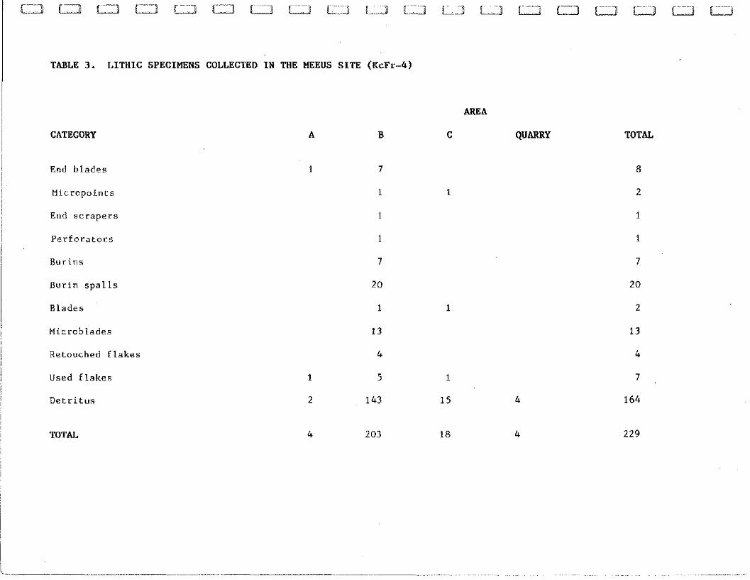
TABLE 3. LITtlIC SPECIMENS COLLECTED I N THE MEEUS S I T E (KcFr-4)
CATEGORY
End blades
Micropoints
End scrapers
Perforators
Burins
Burin spalls
Blades
Microblades
Retouched flakes
Used flakes
Detritus
TOTAL
AREA
QUARRY TOTAL
latter two (2) are frequently translucide, approaching chalcedony
in appearance. Eleven (11) specimens occurred in quartz crystal
and eight (8) in milky quartz. Most of the quartz specimens were
surface collected in Area C and the quarry, only seven (7)
examples of this raw material being recovered in other areas of
the site.
Faunal ~oilection
The eight (8) bone fragments collected in the Meeus site
were recovered from the excavated portion of the hearth area in
Test Zone 11, Area B. These fragments are provisionally
interpreted as sea mammal bones, probably seal.
5.1.2 Mungiok Site (KcFr-7)
Cultural Affiliation: Pre-Dorset
Location
Geographic Co-ordinates:
U.T.M.:
Altitude (m.a.s.1.):
Dis tance/Shoreline (m) :
MAP: 35K/5(1:50 000)
41-51
150
General Description
The Mungiok site is located approximately 190 m north of
the Meeus site, in the northeastern section of the Ivujivik
peninsula (Fig. 3). The site is situated on an extensive gravel
deposit bordered to the north and south by bedrock hills. The
western limit of the site is defined by scattered outcrops grading
into a rolling bedrock surface. The site is bounded to the east by
bedrock sloping abruptly towards Ivujivik Harbour.
The Mungiok site was originally defined by Taylor
(1962:81) as occupying "...a thinly vegetated, rather uneven
area..." measuring "...about 240 by 300 feet" (ca. - 75 x 95 m). However, as redefined during the present survey, the site extends
approximately 180 m north-south and roughly 160 m east-west. This
locality is divided into four (4) occupational areas: North,
South, West and Northeast (Appendix F).
The first two (2) of these areas generally correspond to
the site area described by Taylor (1962). The maximum dimensions
of the South Area, oriented north-south, are 110 m and 40 m and
those of the North Area, oriented east-west, approximately 55 m by
22 m. The North Area is delimited, to the north, by a vertical
bedrock wall about 1.50 m in height; a bog defines the southern
limit of the western half of this area.
The West Area consists of low bedrock outcrops
interspersed with graval deposits. This area, defined on the basis
of observed habitation structures, does not appear to exceed 50 m
in length. The gravel deposits occupied by these structures are
roughly 10 m in width.
The Northeast Area comprises a gravel deposit situated on
the eastern slope of the bedrock hill defining the northern limit
of the site. This area is bordered to the northeast by a vertical
bedrock wall (ca. - 1.2 m in height) and to the southwest by a
bedrock slope. The gravel deposit is 42 m in maximum length by
15 m in maximum width.
Vegetation in the South Area consists of discontinuous
patches of low mosses and lichens. The relatively dense floral
cover in the North Area is composed predominantly of grasses and
sedges intermixed with mosses. Sphagnum occurs along the edge of
the bedrock wall and in the bog delimiting this area. Excluding
scattered lichens, vegetation is lacking is the West and Northeast
areas.
Sampling and Stratigraphy
Folowing brief surface collecting, three (3) test pits
were excavated in the North Area, one ( 1 ) in the West Area and
three (3) in the Northwest Area (Appendix F). All of these pits
were excavated in identified or presumed habitation structures.
The stratigraphies revealed in each of these test pits
consist of undifferentiated marine gravels overlain, in the North
Area, by a thin layer of dark brown organic soil and the
vegetation mat. The organic soil varies from 2 to 10 cm in
thickness. While all cultural material yielded by the test pits
was recovered either in this soil or on the surface of the
underlying gravel, no cultural horizons were observed in any of
the excavated pits.
Habitation Structures
Twenty-seven ( 2 7 ) habitation structures are tentatively
identified in the Mungiok site (Table 4 ) . Sixteen (16) of these
TABLE 4. SUMMARY HABITATION STRUCTURES IDENTIFIED IN THE MUNGIOK SITE (KcFr-7)
AREA STRUCTURE FORM DIMENSIONS(~) REMARKS
1 North A Ova 1 2.50 X 3.00 Against bedrock wall
B Ova 1 1.80 X 2.00
C Circular 2.20 dia.
D Semi-circular 1.40 X 2.00
F Circular 2.0 dia.
G Bilobate 1.90 X 3.00
Circular
Circular
Ova 1
Circular
Circul.ar
Ova 1
Circular
Circular
Ova 1
Oval.
2.00 dia.
1.90 dia.
1.80 X 2.00
2.00 dia.
2.00 dia.
1.80 X 2.30
2.00 dia.
2.00 dia.
1.70 X 2.20
1.60 X 2.00
Against bedrock wall
Against bedrock wall
Possible mid-passage tent ring or overlapping tent rings
Against bedrock wall
Possible house depression
Possible house depression
AREA STRUCTURE
West R
S
Northeast A A
AB
FORM
Ova 1
Oval
Circular
Circular
Circular
Circular
Circular
Circular
Oval
Circular
Bilobate
2.20 X 3.50
2.30 X 3.40
2.50 dia.
2.50 dia.
2.50 dia.
2.90 dia.
2.80 dia.
2.40 dia.
2.40 X 2.60
2.40 dia.
2.10 X 3.20
REMARKS
Possible central hearth E. 65cm dia. Possible central hearth E. 65cm dia.
Possible mid-passage tent ring
Mid-passage measuring - ca.65 cm in width
m= Metre dia.= Diametre
structures occur in the North Area, two (2) in the West Area and
nine ( 9 ) in the Northeast Area. With the exception of two (2)
possible house depressions located in the North Area, all
habitations noted consist of tent rings.
The habitations recorded in the North Area are defined by
loose circular to oval rock alignments or concentrations
associated with patches of denser vegetation including, in several
cases, a relatively thick sphagnum layer. These habitations are
generally clustered along or close to the bedrock wall defining
the northern edge of the area. The eight (8) circular structures
vary between 1.90 and 2.20 m in diametre. The depth of the lithics
recovered in the test pits excavated in two ( 2 ) of these
structures (i.e., J and K) suggest slightly semi-subterranean
dwellings.
The oval tent rings vary from 1.40 to 2.50 m in width by
2.20 to 3.00 m in length. A mid-passage feature or, alternately,
two ( 2 ) overlapping tent rings may be suggested for Structure G.
This bilobate structure measures 1.90 x 3.00 m.
The two ( 2 ) oval tent rings observed in the West Area
(i.e., Structures R and S) measure 2.20 x 3.50 m and 2.30 x 3.40 m
respectively. Irregular concentrations of rocks situated in the
approximate centre of each of these structures are presumed to
represent hearths. Both of these hearths are roughly 65 cm in
diametre.
Of the nine (9) tent rings identified in the Northeast
Area of the site, seven (7) are circular, one (1) is oval and one
( 1 ) is bilobate. The circular structures are somewhat larger than
those in the North Area, varying in diametre from 2.40 to 2.90 m.
The oval Structure AG, possibly containing a mid-passage feature,
is 2.40 m in width by 2.60 m in length. The bilobate Structure AG
measures 2.10 x 3.20. The mid-passage feature in this structure,
oriented north-south, measures approximately 2.00 in length by
65 cm in maximum width. A north-facing entrance to Structure AG is
suggested by slight flaring of the mid-passage.
Secondary Cultural Features
Secondary cultural features observed consist of a
presumed hearth (i.e., Structure E) and a semi-circular alignment
of rocks interpreted as a cache (i.e., Structure AH). The hearth,
situated near the bedrock wall in the North Area, is composed of a
circle of stones measuring 6 0 cm in diametre. The cache,
constructed against the bedrock wall in the Northeast Area,
measures roughly 1.0 m in length by 50 cm in width.
Lithic Specimens
The lithic collection recovered in the Mungiok site
totals fifty-nine (59) specimens (Appendix B). Thirty-nine ( 3 9 ) of
these specimens were surface collected and twenty (20) were
produced by the test pits excavated in Structures J and K, the
North Area. Two ( 2 ) other test pits, excavated in structures C and
S respectively, were negative.
The twenty ( 2 0 ) worked or used specimens comprised in the
collection include a triangular and a stemmed end blade, an end
scraper on a flake, a concave side scraper, a large stemmed knife,
a small perf orator in quartz crystal, a single burin, three ( 3 )
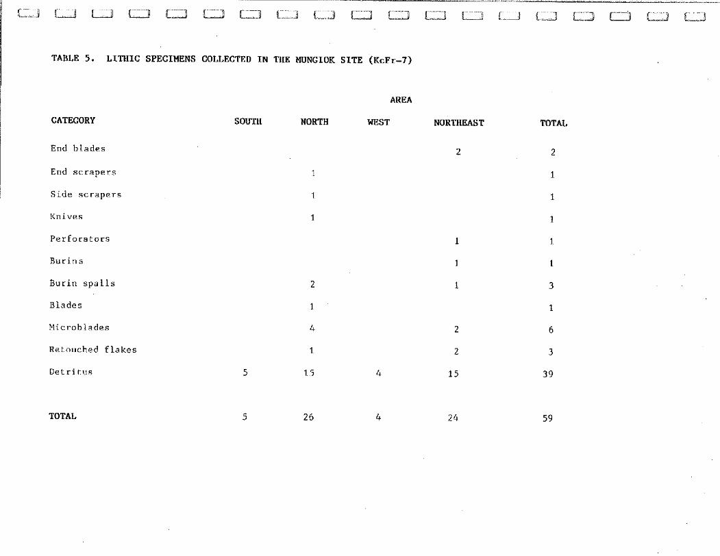
TABLE 5. LITHIC SPECIMENS COLLECTED IN THE MUNGIOK SITE (KcFr-7)
CATEGORY
End b l a d e s
End s c r a p e r s
S i d e s c r a p e r s
Knives
P e r f o r a t o r s
Bur in s p a l l s
Blades
Microblades
Retouched f l a k e s
D e t r i t u s
TOTAL
AREA
SOUTH NORTH WEST NORTHEAST TOTAL
burin spalls and six (6) microblades. All of these specimens were
recovered either in the two (2) positive test pits excavated in
the North Area or on the surface in the Northeast Area.
These test pits and area also yielded twenty-four (24) of
the thirty-nine (39) detritus pieces recovered in the site. Five
(5) flakes were surface-collected in the South Area, four (4) in
the West Area and six (6) others in the North Area.
As in the case of the Meeus site, grey and brown
varieties of chert are the dominant raw material, representing
eighteen (18) of the tool products and thirty-three (33) of the
detritus specimens. The other two (2) tools (i.e., the perforator
and a microblade fragment) as well as the remainder of the
detritus are in quartz crystal.
Faunal Collection
A single sea mammal vertebrate was surface-collected in
the North Area of the site. The large size and porousness of this
v,ertebrate suggests either a large seal species or walrus.
5.1.3 Pita Site (KcFr-5)
Cultural Affiliation: Pre-Dorset
Location
Geographic Co-ordinates:
U.T.M.: MAP: 35K/5 (1:50 000)
Altitude (m.a.s.1.): 37-38
General Description
The Pita site occurs on a marine gravel deposit situated
on the northeastern extremity of a large, drained pond, about 800
m northwest of the village of Ivujivik (Fig. 3 ) . This deposit,
roughly 4 0 0 m southwest of the Mungiok site, is bounded to the
north by the crown of a bedrock hill and to the south by a rolling
bedrock surface. A series of raised gravel beach ridges sloping
northeastward into a small valley define the eastern limit of the
site.
As originally defined by Taylor ( 1 9 6 2 : 8 1 ) , the site I, ... occupies a grass-moss vegetation patch set against the solid rock rim of the valley ..." measuring "...about 450 by 120 feet..."
(s. 1 4 0 x 37 .5 m). Present survey results indicate, however, an
occupation area approximately 90 m in east-west length by 55 m in
north-south width (Appendix G). This area is separated from the
pond to the west by bedrock outcroppings and from the bedrock
surface to the south by a bog. A habitation structure situated on
a small gravel deposit on the bedrock some 4 5 m south of the
occupation area is also included in the site.
Site vegetation is composed of a continuous and dense mat
of grasses and sedges interspersed with low mosses. Sphagnum
occurs in the bog as well as along the edge of the bedrock ledge
forming the northern limit of the site. Excluding some scattered
mosses and lichens, vegetation is lacking on the small gravel
deposit on the bedrock south of the principal occupation area.
Sampling and Stratigraphy
Five (5) of the seven (7) test pits excavated in the Pita
site were located in presumed habitation structures. These pits
produced a variable number of lithics and, in one (1) case,
several bone fragments. Two (2) additional test pits excavated in
the western section of the site proved negative.
The stratigraphy revealed in Test Pit 4, excavated in the
tent ring designated Structure H, is composed of a medium coarse,
sandy gravel, yellowish-brown in colouration. A similar sandy
gravel underlying dark brown organic soils covered by the
vegetation mat occurs in the other test pits. In Test Pits 5, 6
and 7 , both the organic soil layer and overlying vegetation are
approximately 3 cm in thickness. However, in Test Pits 1, 2 and 3
(situated in Structures B, A and D respectively), the organic
soils varied between 10 and 15 cm in thickness (c.f. Appendix C).
Also, in each of these pits these soils were capped by a thick
vegetation layer composed predominantly of sphagnum. The thickness
of this overlying vegetation varied from 12 cm in Test Pit 3
(i.e., Structure D) to roughly 20 cm in Test Pits 1 and 2 (i.e.,
Structures A and B). The combined thickness of the vegetation and
organic soils in these tests suggest semi-subterranean dwellings
for these three (3) sampled structures.
~abitation Structures
A total of eight (8) habitation structures were
identified in the Pita site (Table 6). Three (3) of these
habitations (i.e., Structures E, F and H) consist of circular
alignments of rocks representing tent rings. These structures vary
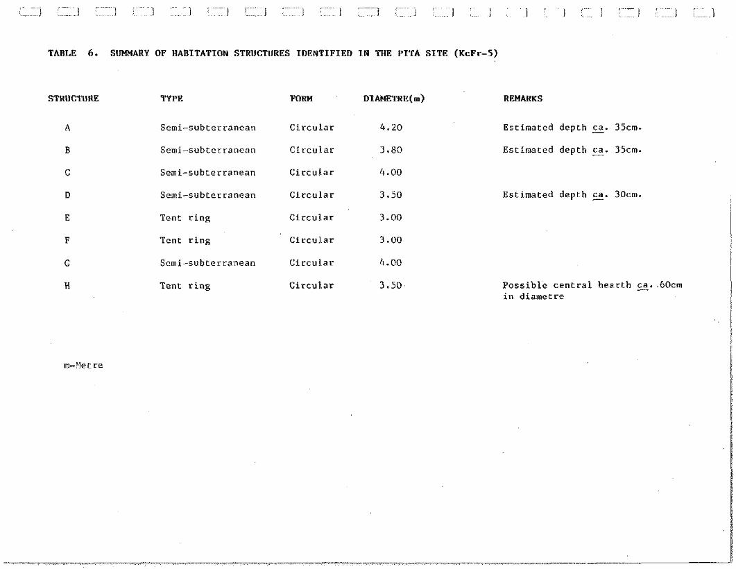
TAEiLE 6 . SUMMARY OF HABITATION STRUCTURES IDENTIFIED IN THE PITA SITE (KcFr-5)
STRUCTURE TYPE FORM DIAMETRE(~)
Semi-subterranean Circular 4.20
Semi-subterranean Circular 3.80
Semi-subterranean Circular 4.00
Semi-subterranean Circular 3.50
Tent ring Circular 3.00
Tent ring Circular 3.00
Semi-subterranean Circular 4.00
Tent ring Circular 3.50
REMARKS
Estimated depth z. 35cm. Estimated depth E. 35cm.
Estimated depth z. 30cnl.
Possible central hearth E. 60cm in diametre
between 3.00 and 3.50 m in diametre. A small concentration of
stones approximately 65 cm in diametre located in the centre of
Structure H is interpreted as a hearth.
The other five (5) structures are interpreted as semi-
subterranean dwellings. These dwellings, clustered in the central
section of the site, are defined by slight circular depressions
containing a thick sphagnum layer intermixed with grasses and
sedges. Several rocks occur along the edge of each of these
depressions. The depressions vary in diametre from 3.80 to 4.20 m.
Stratigraphic profiles recorded in Structures A, B and D suggest
depths of 30 to 35 cm for these dwellings. Similar depths may be
presumed for Structures C and G.
Lithic Specimens
A total of eighty (80) lithic specimens, only one (1) of
which was surface-collected, were recovered in the Pita site
(Appendix B). This collection comprises thirty-four (34) worked or
used specimens and fifty-six (56) detritus pieces (Table 7).
The worked and used specimens include two (2) micropoints
(one in chert and the other in milky quartz), six (6) burins, a
single burin blank, six (6) complete or fragmentary microblades
and seven (7) retouched flakes. The majority of the tools,
including both micropoints, were recovered in Structure A. Each of
the sampled structures yielded at least one (1) burin.
The detritus includes debitage flakes as well as small
edge retouch chips. Thirty (30) of these pieces were recovered in
Test Pit 2, Structure A. The number of detritus and worked tools
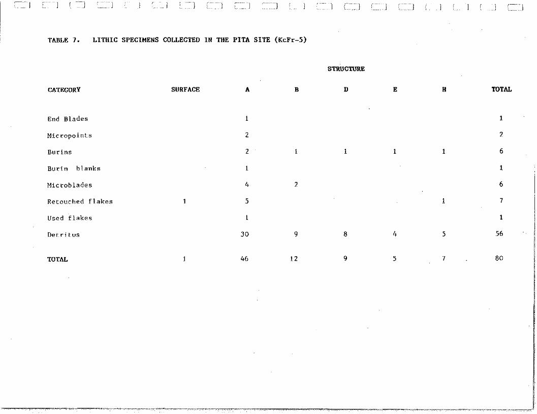
TABLE 7 . LITHIC SPECIMENS COLLECTED I N THE PITA S I T E (KcFr-5 )
STRUCTURE
CATEGORY
End Blades
Micropoints
Burin blanks
Microblades
Retouched flakes
Used flakes
Detritus
TOTAL
SURFACE TOTAL
produced by this test pit suggests an activity area in this
dwelling.
The dominant raw material is chert (N = 44), followed by
milky quartz (N = 17) and quartz crystal (N = 10). Six (6)
specimens occur in a fine-grained black quartzite and one (1) in a
translucide, grey quartzite. These quartzites approach Ramah
quartzite in grain size and texture. Metabasalt is represented by
two (2) flakes, one (1) of which is marginally retouched. --
Faunal Collection
The faunal collection consists of eight (8) bone
fragments, all of which were recovered in Test Pit 2, Structure A.
These remains are tentatively interpreted as comprising three (3)
small rib fragments, three (3) auditory process fragments and two
(2) toe bones. Several of these bones are burnt. Provisional
interpretation of the bones suggests sea mammal remains, possibly
a large seal species.
5.1.4 Ohituk Site (KcFr-3)
Cultural Affiliation: Dorset
Location
Geographic Co-ordinates:
U.T.M.: MAP: 35K/5(1:50 000)
Altitude (m.a.s.1.): 16 - 23 Distance/Shoreline (m) : 100
General Description
The Ohituk Site is situated on marine deposits in the
mouth of a narrow valley on the north coast of the Ivujivik
peninsula, roughly 800 m northwest of the village (Fig. 3). The
site is located approximately 250 m west of the Mungiok site and
about 175 m north of the Pita site.
The site is bordered to the east and west-by abruptly
sloping bedrock hills. The northern limit of the site is defined
by the 16 m.a.s.1. gravel beach ridge and the south limit, by the
23 m.a.s.1. terrace (Appendix G). An extensive rectangular
depression observed in the beach ridge suggests that this
formation corresponds to the excavated portion of the site
mentioned in Taylor (1960:2). As currently defined, however, the
principal occupation area of the site occurs on the terrace, some
50 m south of the beach ridge.
The terrace is divided into two ( 2 ) sections by a
permanent stream flowing from the drained pond to the south on
which the Pita site is located. The eastern section of the terrace
is composed of a boulder field and the western section of an
eroding sand-gravel bank (see Photo 30). The erosion of this bank,
yielding a considerable number of cultural remains, was seriously
influenced by the increased stream discharge occasioned by the
draining of the pond. The portion of the stream-bed bisecting the
terrace was also significantly down-cut by this temporary increase
in outflow.
The site is approximately 75 m in overall length by 75 m
in maximum width. The boulder field forming the eastern half of
the terrace measures roughly 30 m in length by 15 m in width. The
eroding bank is about 30 m long.
A dense patch of long grasses and sedges predominates on
the gravel. beach ridge. Vegetation on the western section of the
terrace is composed mainly of short grasses mixed with low mosses.
Scattered mosses and lichens occur on the boulder field. The wet
area separating the gravel ridge from the terrace is occupied by
sphagnum interspersed with grasses and other mosses.
Sampling and Stratigraphy
Five (5) standard test pits were excavated in the Ohituk
site. Two ( 2 ) of these pits were located on the western section of
the terrace, close to the stream. One (1) each of the other test
pits were excavated in three ( 3 ) of the habitation structures
identified in the boulder field.
The stratigraphy recorded in the first two ( 2 ) pits is
identical to that observed along the upper portion of the eroding
bank. This stratigraphy is composed of medium coarse sandy gravel
overlain by dark to medium brown organic soil. This soil layer,
permeating into the underlying gravel, varies from 3 to 7 cm in
thickness. The vegetation mat covering the organic soil is 2 to
3 cm in average thickness.
The test pits excavated in the eastern section of the
terrace indicate that the boulder field overlies a coarse gravel
deposit. This deposit occurs roughly 25-30 cm below the surface of
the boulder field. No cultural layers or horizons were observed in
any of the test pits.
Habitation Structures
The four (4) habitation structures identified in the
Ohituk site comprise a circular tent ring and three (3) bilobate
mid-passage tent rings. These structures are aligned along the
length axis of the boulder field forming the eastern half of the
terrace. The distance between the tent rings varies from 1 to 5 m.
The circular Structure A is roughly 4.50 m in diametre.
The comparative lack of lichens on the rocks defining this
structure may indicate an historic origin for this tent ring.
However, the lack of associated cultural material does not allow
confirmation of this suggestion.
The bilobate Structures B, C and D range from 3.00 to
3.10 m in width and from 3.70 to 3.80 m in length. The mid-passage
features in each of these structures, defined by parallel rows of
rocks, are 60 to 65 cm in average width. The features are unformly
oriented north-south (magnetic). Entrances facing towards the sea
to the north are suggested for each of the bilobate structures.
Secondary Cultural Features
A single metal fox-trap represents the only secondary
cultural feature observed in the site. This fox-trap is situated
in Structure A. No temporal relationship is suggested between the
trap and the occupation of the structure.
TABLE 8. SUMMARY OF HABITATION STRUCTURES IDENTIFIED IN THE OISITUK SITE (KcFr-3)
STRUCTURE TYPE
Tent ring
Tent ring
Tent ring
Tent ring
FORM
Circular
Bilobate
Bilobate
Bilobate
DIMENSIONS (m) REMARKS
4.50 dia. Possibly historic
3.00 x 3.80 Mid-passage feature ca. 65 cm in width -
3.10 x 3.80 Mid-passage feature ca. 60 cm in width -
3.00 x 3.70 Mid-passage feature ca. 60 cm in width -
m= Metre dia.= Diametre
Lithic Specimens
Lithic specimens recovered in the Ohituk site are
represented by two (2) incomplete microblades and fifty-three (53)
detritus pieces (Appendix B). The majority of these pieces
consists of small edge retouch chips. All specimens were collected
along the easternmost edge of the eroding bank, the five (5) test
pits excavated proving negative. . --
The collection is comprised uniquely of chert. Banded and
dark grey varieties are numerically predominant, followed by light
grey and bluish-black cherts.
Faunal Collection
No faunal materials were collected in the site during the
present survey. However, numerous small bone fragments were
observed along the edge of the eastern half of the eroding bank
(see Photo 31). As in the case of the lithics, these fragnents
appear to be eroding from the organic soil layer.
Cultural Affiliation: Pre-Dorset, Dorset, Historic
Inuit
Location
Geographic Co-ordinates:
U.T.M.:
Altitude (m.a.s.1.):
MAP: 35K/5
28.80 - 32.50
Distance/Shoreline (m):
General Description
The Ivujivik-1 site is located on the eastern slope of a
bedrock hill approximately 900 m north of the village (Fig. 3).
The site is situated on the southern edge of a deep rock valley
crossing the northern extremity of the Ivujivik peninsula. A small
pond discharging both westward into Digges Sound and eastward into
Ivujivik Harbour occurs in this narrow valley. The southern limit
of the site is approximately 100 m north of the Mungiok site.
Three (3) occupational areas defined by habitation
structures and secondary cultural features are identified in the
site (Appendix H).~.,,.~e first of these areas, Area A, occupies a .,- 1 ~~ .
relatively flat,(.gravel.kerrace . . - bounded, to the north, by the
valley and, to the east, by bedrock outcrops. This area is roughly
6 5 m in length by 45 m in width.
Area B, the altitudinally highest section of the site, is
situated some 25 m southwest of the southern extremity of Area A. ~. .~ .
, ,,
This second area consists of a gradually slopinigrave1,ideposit
bordered to the northwest by a smooth bedrock wall exceeding 6 m
in height. The gravel deposit is delimited to the southeast by a
rounded bedrock slope. Area A is 34 m in maximum length by 15 m in
maximum width.
Area C occurs on a (gravel; deposit in a crevasse . ~...~ ,'
approximately 40 m south of Area A and 18 m east of Area B. As in
the case of Area B, this third occupational area is connected with
Area A by a narrow bedrock corridor. The Area C gravel deposit
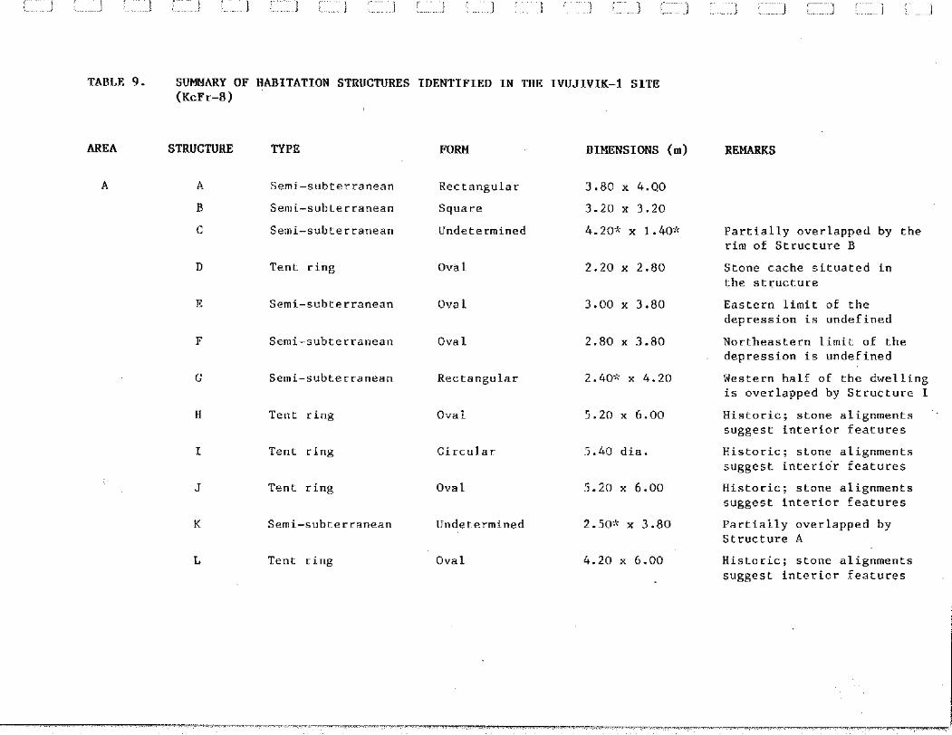
TABLE 9. SUMMARY OF HABITATION STRUCTURES IDENTIFIED IN THE IVUJIVIK-I SITE (KcFr-8)
AREA STRUCTURE
A A
R
C
TYPE
Semi-subterranean
Semi-subterranean
Semi-subterranean
Tent ring
Semi-subterranean
Semi-subterranean
Semi-subterranean
Tent ring
Tent ring
Tent ring
Semi-subterranean
Tent ring
FORM
Rectangular
Square
Undetermined
Ova l
Ova 1
Ova l
Rectangular
Ova 1
Circular
Ova l
Undetermined
Ova 1
DIMENSIONS (m)
2.40% x 4.20
5.20 x 6.00
5.h0 dia.
5.20 x 6.00
2.50* x 3.80
4.20 x 6.00
REMARKS
Partially overlapped by the rim of Structure B
Stone cache situated in the structure
Eastern limit of the depression is undefined
Northeastern limit of the depression is undefined
Western half of the dwelling is overlapped by Structure I
Historic; stone alignments suggest interior features
Historic; stone alignments suggest interior features
Historic; stone alignments suggest interior features
Partially overlapped by Structure A
Historic; stone alignments suggest interior features
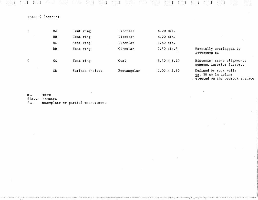
TABLE 9 (cont'd)
B BA Tent ring
BB Tent ring
BC Tent ring
BD Tent ring
Circular
Circular
Circular
Circular
CA Tent ring Ova 1
CB Surface shelter Rectangular
4.20 dia.
4.20 dia.
3.80 dia.
2.80 dia." Partially overlapped by Structure BC
Historic; stone alignments suggest interior features
Defined by rock walls ca. 50 cm in height - erected on the bedrock surface
m = betre dia. = Diametre .!. - ,. .. Incomplete or partial measurement
measures about 15 m by 20 m. A stone cache and habitation
structure located on the bedrock east of this deposit are also
included in this area.
Vegetation in Area A is composed of a dense, continuous
cover of grasses and low mosses interspersed with patches of
longer grasses and sedges. Excluding scattered mosses and lichens,
vegetation is lacking in Areas B and C.
Sampling and Stratigraphy
A total of five (5) 50 cm x 50 cm test pits were
excavated in two (2) semi-subterranean dwellings in Area A and
three (3) tent rings in Area B. The former were positive and the
latter, negative.
The stratigraphy revealed in the Area A test pits is
composed of a relatively thin layer of dark brown organic soil
underlain by medium coarse sandy gravel. The soil layer averages 4
cm in thickness. The overlying vegetation mat is also
approximately 3 cm thick. Stratigraphic profiles recorded in Area
C consist of undifferentiated sandy gravel.
Habitation Structures
Eighteen (18) habitation structures were identified in
the Ivujivik-l site (Table 9). Twelve (12) of these structures,
comprising seven (7) semi-subterranean dwellings and five ( 5 ) tent
rings, are situated in Area A. Four ( 4 ) other tent rings occur in
Area B. The remaining two (2) structures are represented by a tent
ring and surface shelter constructed on the bedrock in Area C.
Pieces of rubber, canvas and metal as well as other
modern remains noted in Structures H, I, J and L, Area A, and in
Structure CA, Area C, indicate recent historic Inuit occupations
for these five (5) large tent rings. Furthermore, the size of
these tent rings, ranging from 6.00 to 8.20 m in length and from
5 . 2 0 to 6 . 4 0 m in width or diametre, suggest multi-family
occupations for these structures. This suggestion is supported by
rock alignments and concentrations in these tent rings indicating
interior partitions and spatially-discrete hearth areas. The fifth
tent ring located in Area A (i.e, Structure D) and the surface
shelter observed in Area B (i.e., Structure CB) may also relate to
historic Inuit occupations of the site.
The semi-subterranean dwellings recorded in Area A are
defined by shallow to moderately deep depressions occupied,
generally, by more luxuriant vegetation. These depressions,
several of which are overlapping, are clustered either on or close
to the edge of the terrace. Fully definable depressions, including
square, rectangular and oval forms, vary between 3.20 and 4.00 m
in length and from 3.00 to 3.80 m in width. Similar ranges are
suggested for the dimensions of the incompletely definable house
depressions.
Lithic raw materials yielded by test pitting in
Structures A and B suggest Dorset occupations for these two ( 2 )
dwellings. The other semi-subterranean dwellings are also
tentatively interpreted as Dorset habitations.
The four ( 4 ) circular tent rings situated in Area C vary
from 2 . 8 0 m to 4 . 2 0 m in diametre. These structures are
provisionally interpreted as Pre-Dorset in cultural affiliation.
This interpretation is based, in part, on the altitude of this
occupation area and, in part, on the variety of chert collected in
this area.
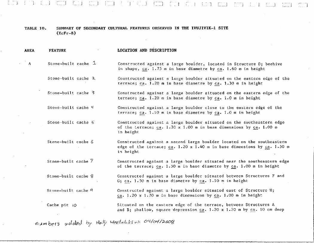
Secondary Cultural Features
As summarized in Table 10, secondary cultural features
noted in the site include nine (9) stone-built caches and four (4)
presumed cache pits in Area A; two (2) caches and a rock alignment
in Area B; and two (2 ) stone-built caches and an exterior hearth
in Area C.
The caches in Areas A and C are built of thick slabs and
rounded cabbles. Most of these caches are beehive in shape,
varying between 1.20 and 2.20 m in base dimensions and between
roughly 1.00 and 1.60 m in height. All have been constructed
against large boulders. These features presumably relate to
historic use of the site.
The two (2) caches identified in Area B are defined by
semi-circular alignments of rocks situated against the bedrock
wall. Several other rocks occur within both of these alignments.
These features are presumed to be associated with the Pre-Dorset
occupation suggested for this area.
The cache pits are defined by three ( 3 ) square and one
( 1 ) oval depressions. The square examples vary from 80 cm x 80 cm
to 1.20 x 1.20 m in dimensions; the oval depression is 1.20 m in
width by 1 . 5 0 m in length. Each of the depressions is
approximately 10 cm in depth. These features, all of which are
,- ~~~ ,~~ , . ~ . ~ ..... i 1 . 1 i . . J [ ] : . ~ ~ . ~ ~ ~ ~ . 1
TABLE 10. SUMMARY OF SECONDARY CULTURAL FEATURES OBSERVED IN THE IVUJIVIK-1 SITE (KcFr-8)
AREA FEATURE LOCATION AND DESCRIPTION
A Stone-built cache 1 Constructed against a large boulder, located in Structure D; beehive in shape, - ca. 1.75 m in base diametre by - ca. 1.60 m in height
Stone-built cache 2. Constructed against a large boulder situated on the eastern edge of the terrace; s. 1.20 m in base diametre by - ca. 1.30 m in height
Stone-built cache 3 Constructed against a large boulder situated on the eastern edge of the terrace; z. 1.20 m in base diametre by s. 1.0 m in height
Stone-built cache '4 Constructed against a large boulder close to the eastern edge of the terrace; s. 1.10 m in base diametre by E. 1.0 m in height
Stone-built cache 5 Constructed against a large boulder situated on the southeastern edge of the terrace; - ca. 1.30 x 1.00 m in base dimensions by s. 1.00 m in height
Stone-built cache 6 Constructed against a second large boulder located on the southeastern edge of the tcrrace; - ca. 1.20 x 1.40 m in base dimensions by - ca. 1.50 m in height
Stone-built cache ? Constructed against a large boulder situated near the southeastern edge of the terrace; - ca. 1.50 m in base diametre by s. 1.00 m in height
Stone-built cache 8 Constructed against a large boulder situated between Structures F and G; s. 1.50 m in base diametre by s. 1.10 m in height
Stone-bui lt cache 9 Constructed against a large boulder situated east of Structure H; ca. 1.20 x 1.70 m in base dimensions by g. 1.00 m in height -
Cache pit 10 Situated on the castern edge of the terrace, between Structures A and B; shallow, square depression s. 1.20 x 1.20 m by %. 10 cm deep
TABLE 10. SllMMARY OF SECONDARY CULTURAL FEATURES OBSERVED IN THE IWJIVIK-1 SITE (KcFr-8)
AREA FEATURE
Cache pit 1 1
Cache pit I2
Cache pit 13
B Stone-built cache iY
Stone-built cache 15
Rock alignment
C Stone-built cache 16
Stone-built cache 1 ?
Hearth
LOCATION AND DESCRlPTION
Situated on the eastern edge of the terrace between Structures A and B; square in shape, G. 1.10 x 1.10 m by s. 10 cm deep
Situated on the eastern edge of the terrace between Structure B and a large boulder; square in shape s. 80 x 80 cm by ca. 10 cm deep - Situated west of Structure G; oval in shape s. 1.20 x 1.50 m by ca. 10 cm deep -
Semi-circular alignment of rocks located against the bedrock wall in the eastern extremity of the area; z. 1.20 x 1.50 m . ,
Semi-circular alignment of rocks located against the bedrock wall, contiguous with Structure BC; G. 1.0 x 2.0 m
Alignment of five (5) small boulders extending onto the bedrock east of Structure BB; oriented east-west, E. 4.5 m in length '
Constructed against a large boulder northeast of Structure CA; beehive in shape, s. 1.40 x 2.20 m in base dimensions by s. 1.50 m in height
Constructed against a large boulder southeast of Structure CA; %. 1.40 x 2.00 m in base dimensions by - ca. 1.0 m in height
Composed of two (2) rectangular blocks situated on the bedrock ledge northeast of Structure CA; E. 25 x 45 cm in overall dimensions
situated close to semi-subterraneans dwellings, are suggested as
being associated with the Dorset occupation of the site.
The rock alignment in Area B consists of five (5) evenly-
spaced angular blocks. This alignment, oriented east-west, is
approximately 4.5 m in length. Although possibly of Pre-Dorset
origin, the function of this feature remains undetermined.
The exterior hearth noted in Area C is compsed of two
(2) rectangular blocks situated on a low bedrock ledge. Both of
these blocks are roughly 25 cm in length by 10 cm in width and
thickness. The space between the blocks, approximately 25 cm in
length, contains charcoal fragments and burnt moss. This hearth is
probably associated with an historic occupation of Area C.
Lithic Specimens
Twenty-one (21) lithic specimens were recovered in the
Ivu jivik-1 site (Appendix B). Three (3) of these specimens were
collected on the surface of Area B and three (3) others in the
test pit in Structure BA in this area (Table 11). The remaining
fifteen (15) lithics were recovered in the Structure A and B test
pits, Area A.
Worked or used specimens, totalling five (5) objects,
include a blade, a microblade and a burin spa11 from Area B. A
second microblade and a fragment of a microblade core were yielded
by the Structure A and B test pits respectively. All of these
specimens are in chert.
TABLE 11. LITHIC SPECIMENS COLLECTED I N TlfE IVUJIVIK-1 S I T E (kCFr-8)
CATEGORY
Blade
Microbladc
Microblade core
Burin spa11
Detritus
SURFACE
(AREA B )
STRUCTURE
A B B A
TOTAL
Of the sixteen (16) detritus pieces, thirteen (13) were
collected in sampled semi-subterranean dwellings in Area A. Eight
(8) of these pieces are in chert and one (1) in milky quartz; the
other four (4) are in Ramah quartzite. The three (3) rough flakes
retrieved in Area B are in chert.
Faunal Collection
Numerous bones and bone fragments were observed on the
surface of Area A. None of these bones were collected. However,
test pit 1, Structure A, yielded four (4) small bone fragments.
These fragments remain unidentified.
Cultural Affiliation: P r e- Dors e t , Dorset and
(possibly) Thule
Location
Geographic Co-ordinates:
U.T.M.: MAP: 35K/5 (1:50 000)
Altitude (m.a.s.1.): 34.6
Distance/Shoreline (m): 450
General Description
The Ivujivik-2 site is located approximately 800 m west-
southwest of the village (Fig. 3). The site occupies a relatively
flat gravel deposit situated on the western edge of a small pond.
This deposit, measuring roughly 45 m by 55 m, is bordered to the
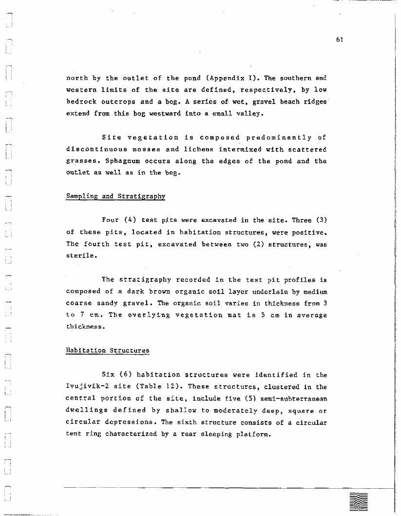
north by the outlet of the pond (Appendix I). The southern and
western limits of the site are defined, respectively, by low
bedrock outcrops and a bog. A series of wet, gravel beach ridges
extend from this bog westward into a small valley.
Site vegetation is composed predominently of
discontinuous mosses and lichens intermixed with scattered
grasses. Sphagnum occurs along the edges of the pond and the
outlet as well as in the bog.
Sampling and Stratigraphy
Four (4) test pits were excavated in the site. Three (3)
of these pits, located in habitation structures, were positive.
The fourth test pit, excavated between two (2) structures, was
sterile.
The stratigraphy recorded in the test pit profiles is
composed of a dark brown organic soil layer underlain by medium
coarse sandy gravel. The organic soil varies in thickness from 3
to 7 cm. The overlying vegetation mat is 5 cm in average
thickness.
Habitation Structures
Six (6) habitation structures were identified in the
Ivujivik-2 site (Table 12). These structures, clustered in the
central portion of the site, include five ( 5 ) semi-subterranean
dwellings defined by shallow to moderately deep, square or
circular depressions. The sixth structure consists of a circular
tent ring characterized by a rear sleeping platform.
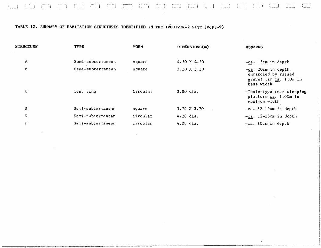
TABLE 12. SUMMARY OF HABITATION STRUCTURES IDENTIFIED IN THE IWJIVIK-2 SITE (KcFr-9)
STRUCTURE TYPE FORM DIMENSIONS(~)
Semi-subterranean square 4.50 X 4.50
Semi-subterranean square 3.50 X 3.50
C Tent ring Circular 3.80 dia.
Semi-subterranean square 3.70 X 3.70
Semi-subterranean circular 4.20 dia.
Semi-subterranean circular 4.00 dia.
REMARKS
-ca. - 15cm in depth -ca. - 20cm in depth, encircled by raised gravel rim E. 1.0m in base width
-Thule-type rear sleeping platform z. 1.60m in maximum width
-ca. - 12-15cm in depth -ca. - 12-15cm in depth -ca. - lOcm in depth
The dimensions of the square dwellings range from 3.50 x
3.50 m to 4.50 x 4.50 m. Two (2) of these structures (i.e., A and
B), one (1) which is bordered by a raised gravel rim, are
interpreted as Dorset habitations. The other square dwelling
(i.e., Structure D) and the two (2) circular depressions (i.e.,
Structures E and F) are tentatively interpreted as Pre-Dorset in
cultural affiliation. The latter dwellings are 4.00 m and 4.20 m
in diametre respectively.
The sleeping platform in Structure C suggests that this
tent ring may relate to a Thule occupation of the site. This
structure is 3.80 m in diametre. The sleeping platform, defined by
a row of flat strones transecting the southern portion of the tent
ring, is approximately 1.60 m in maximum width.
Secondary Cultural Features
Secondary cultural features noted in the site are
represented by two (2) small circular depressions interpretated as
cache pits. These depressions, located in the southeastern section
of the site, are about 1.50 m in diametre and roughly 10 cm in
depth. The cultural affiliation of these features is undetermined.
Lithic Specimens
A total of twenty-two ( 2 2 ) lithic specimens were
recovered from the three (3) positive test pits excavated in the
site (Appendix B). These specimens include a burin, two (2)
retouched flakes and two ( 2 ) used flakes. The seventeen (17)
detritus pieces comprise sixteen (16) flakes, flake fragments and
edge retouch chips and a single debris.
The five (5) worked or used specimens and thirteen (13)
of the detritus pieces are in chert. Milky quartz and quartz
crystal are each represented by a single flake. The remaining two
(2) rough flakes are in metabasalt.
Cultural Affiliation: Dorset
Location
Geographic Co-ordinates:
U.T.M.:
Altitude (m.a.s.1.):
Distance/Shoreline (m) :
MAP: 35K/5
22 - 32 80
General Description
The Ivujivik-3 site is situated on the southwest shore of
Ivujivik Harbour, close to the bottom of the harbour (Fig. 3). The
site, located approximately 2.5 km southeast of Ivujivik, is
divided into three (3) occupation areas.
The principal occupation area occupies a small boulder
field on the east side of a low bedrock formation (Appendix I).
The boulder field, roughly 52 m in length by 40 m in width, is
bordered on the east, west and south by rock ledges. A rounded
bedrock surface sloping towards Ivujivik Harbour defines the
northern limit of the area.
The second area is east of the bedrock formation
bordering the principal occupation area. This area consists of a
flat gravel deposit extending along the north shore of a small
pond. The deposit, approximately 150 m in length by 100 m in
width, is delimited to the north and west by an extensive sphagnum
bog. Numerous rocks densely scattered across the deposit suggest
an undetermined number of possible tent rings. However, no
habitation structures were clearly definable in this area.
The third area comprises a small gravel deposit on the
west side of an isolated rock pinnacle situated some 250 m west of
the small pond. The deposit, the elevationally highest section of
the site, is roughly 25 m in length by 10 m in width. A surface
shelter and two ( 2 ) small stone caches occur in this last area of
the site.
Vegetation in the latter two (2) occupation areas
consists of sparse mosses and grasses. Lichens and small,
scattered patches of low moss occur in the boulder field.
Sampling
Extensive surface collecting carried out in the
occupation areas defined in the site produced neither lithics nor
bone or other organic remains. Due to time limitations and the
character of the surface deposits, no test pits were excavated in
any of these areas.
Rabitation Structures
Of the eight (8) habitation structures recorded in the
Ivujivik-3 site, three (3) are surface shelters and five ( 5 ) are
tent rings (Table 13). Two (2) of the surface shelters are located
on bedrock ledges peripheral to the boulder field and the third,
adjacent to the rock pinnacle in the westernmost site area. The
tent rings occur in the boulder field.
The surface shelters consist of a short rear wall and
longer lateral wall parallelled by a straight section of bedrock
ledge. The height of the walls, built of relatively large angular
rocks and thick, upright slabs, are 50 to 60 cm in height.
The open ends of these rectangular structures are
variously oriented towards the southeast, northwest and east.
These habitations vary between 1.50 and 2.80 m in width and from
2.20 to 3.40 m in length.
Of the tent rings identified in the boulder field, two
( 2 ) are square, two (2) are circular and one (1) is semi-circular.
The latter (i.e., Structure D) is constructed against a bedrock
ridge. These structures are defined, on the one hand, by
geometrical patches of vegetation and, on the other, by
symmetrical alignments of rocks supporting lichen growth
observably different from that covering the boulder field. The
largest of these tent rings i e , Structures F and G) measure
4.40 m by 4.40 m; the smallest (i.e., Structure D) is 2.0 m width
by 4.0 m in length.
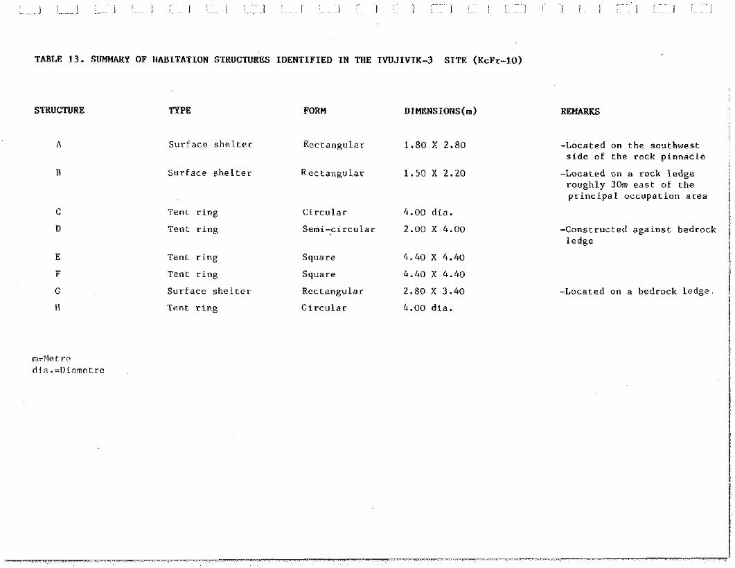
c-~ -~ . ,~ ~~ ~ I ,~~ ~~ . <---~ I I . . I i . 1 I I 1 ..... I I I I J i l l
TABLE 13. SUMMARY OF HABITATION STRUCTURES IDENTIFIED IN THE IWJIVIK-3 SITE (KcFr-10)
STRUCTURE TYPE
S u r f a c e s h e l t e r
S u r f a c e s h e l t e r
Ten t r i n g
Ten t r i n g
Tent r i n g
Ten t r i n g
S u r f a c e s h e l t e r
T e n t r i n g
FORM DIMENSIONS(~)
R e c t a n g u l a r 1.80 X 2.80
R e c t a n g u l a r 1.50 X 2.20
C i r c u l a r 4.00 d i a .
Semi- ,c i rcular 2.00 X 4.00
Square 4.40 X 4.40
Square 4.40 X 4.40
R e c t a n g u l a r 2.80 X 3.40
C i r c u l a r 4.00 d i a .
REMARKS
-Located on t h e sou thwes t s i d e of t h e rock p i n n a c l e
-Located on a rock l e d g e r o u g h l y 30m e a s t of t h e p r i n c i p a l o c c u p a t i o n a r e a
-Cons t ruc ted a g a i n s t bedrock l e d g e
-Located on a bedrock l edge
- 1 8 1. :
- L.,
- , ,
1, j
-, . ,
I ,. ~,
- , ,
, ,
,.-. 1
: : L ,.
.-
~,
-- , , , . I i.?
- , , : I
L,, 3
- 1
, ~,
- !
, , , , &, .,
-
Secondary Cultural Features
Observed secondary cultural features are represented by
two (2) small caches and an exterior hearth. The caches, located
in the westernmost area of the site, are built of cobbles. These
features are roughly 80 cm in base diametre by about 50 cm in
height.
The hearth is situated in the boulder field,
approximately 2 m north of Structure C. This feature is defined by
a small vegetation patch encircled by cobbles on which the lichen
cover contrasts with that of the surrounding boulder field (see
Photo 55). Several charcoal fragments were noted in the vegetation
patch. The hearth is 55 cm in diametre.
Cultural Affiliation: Pre-Dorset
Location
Geographic Co-ordinates:
U.T.M.: MAP: 35K/5 (1:50 000)
Altitude (m.a.s.1.): 32 - 36 Distance/Shoreline (m): 400
General Description
The Ivujivik-4 site is situated on the northeastern edge
of a long pond located in a narrow valley, approximately 180 m
southwest of Ivujivik-3 (Fig. 3). The site occupies a gravel
deposit bounded to the north by an abruptly rising bedrock hill
(Appendix J). The deposit, roughly 130 m in length by 85 m in
width, is separated from the bedrock formation to the south by the
pond outlet. The eastern limit of the site is defined by a bog and
a series of raised gravel ridges.
Site vegetation is sparse, consisting predominantly of
low mosses, lichens and scattered grasses. Sphagnum occurs along
the edge of the pond and outlet as well as in the bog.
Sampling and Stratigraphy
Two (2) test pits were excavated in different habitation
structures. Both of these pits were positive.
The stratigraphy revealed in these test pits is composed
of a thin layer of dark brown organic soil underlain by medium
coarse sandy gravel. The soil layer varies in thickness from 3 to
5 cm. The overlying vegetation cover averages about 3 cm in
thickness.
Habitation Structures
Eight (8) tent rings were identified in the Ivujivik-4
site (Table 14). These structures are generally distributed along
the periphery of the site. Also, relatively extensive
concentrations of scattered rocks in the centre and northeastern
section of the site suggest possible habitation areas. However, no
tent rings or other cultural features were clearly definable in
either of these concentrations.
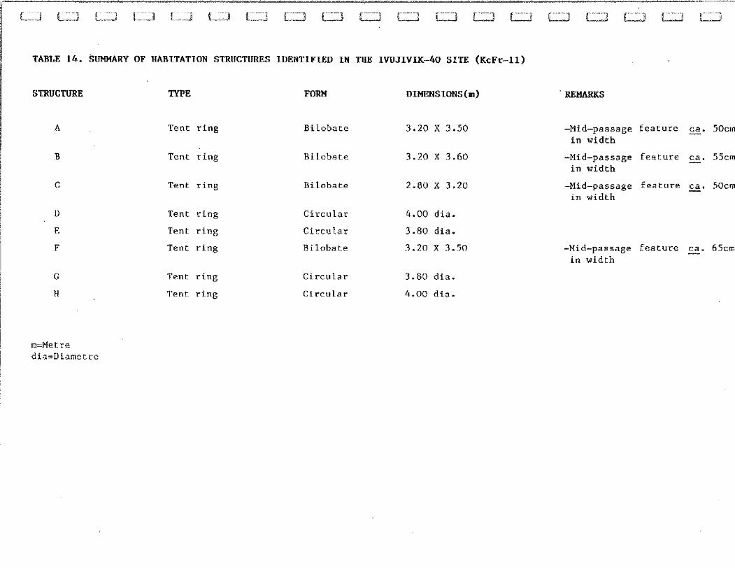
TABLE 14. SUMMARY OF HABITATION STRUCTURES IDENTIFIED IN THE IWJIVIK-40 SITE (KcFr-11)
STRUCTURE TYPE FORM DIMENSIONS(m)
Tent ring
Tent ring
Bilobate 3.20 X 3.50
Bilobate 3.20 X 3.60
C Tent ring Bilobate 2.80 X 3.20
Tent ring
Tent ring
Tent ring
Tent ring
Tent ring
Circular 4.00 dia.
Circular 3.80 dia.
Rilobate 3.20 X 3.50
Circular 3.80 dia.
Circular 4.00 dia.
REMARKS
-Mid-passage feature s. 50ca in width
-Mid-passage feature E. 55cn in width
-Mid-passage feature E. 50crr in width
-Mid-passage feature E. 65cm in width
Four (4) of the tent rings identified are circular and
four (4) are bilobate in shape. The circular structures are of
relatively consistent dimensions, ranging from 3.80 to 4.00 m in
diametre. The bilobate forms vary between 2.80 and 3.20 m in width
and from 3 . 2 0 to 3 . 6 0 in length. Each of the latter is
characterized by a mid-passage feature. These features range from
50 to 6 5 cm in width. The orientation of the mid-passages in
Structures A and B suggest south-facing entrances. Entrances
facing west towards the pond and east towards Ivujivik Harbour are
interpreted for Structures C and F respectively.
Secondary Cultural Features
A metal fox-trap located in the approximate centre of the
site represents the only secondary cultural feature observed in
the site.
Lithic Specimens
The nine (9) lithic specimens collected in the site
comprise one (1) retouched flake and eight ( 8 ) rough flakes or
flake fragments (Appendix B). These specimens, all of which are in
chert, were recovered from the test pits excavated in Structures A
and C.
Faunal Collection
Four (4) bone fragments were yielded by the test pit
excavated in Structure C. These remains, tentatively identified as
seal, include a vertebrate and three ( 3 ) small fragments
provisionally interpreted as head bones.
Cultural Affiliation: Undetermined Paleoeskimo
Location
Geographic Co-ordinates:
U.T.M.:
Altitude (n.a.s.1.):
Distance/Shoreline (m) :
'
MAP: 35K/5
36
260
General Description
The Ivujivik-5 site is situated on the northern rim of a
broad valley roughly 200 m northwest of Ivujivik-2 (Fig. 3). This
slope of the valley is composed of a series of raised gravel
ridges interspersed with several small bedrock outcrops. The
locality is bounded to the west by a low, rounded bedrock ridge
and to the north and east by a rolling rock surface.
Vegetation is composed of a dense and continuous moss-
grass cover mixed with sphagnum. Sphagnum predominates in several
zones of limited extent scattered across the locality.
Sampling and Stratigraphy
A total of twenty-one (21) 50 cm x 50 cm test pits were
excavated throughout the locality. Eleven (11) of these test pits
were excavated at 1-metre intervals and the other ten (lo), at
variables distances from these pits (Fig. 4). Sampling
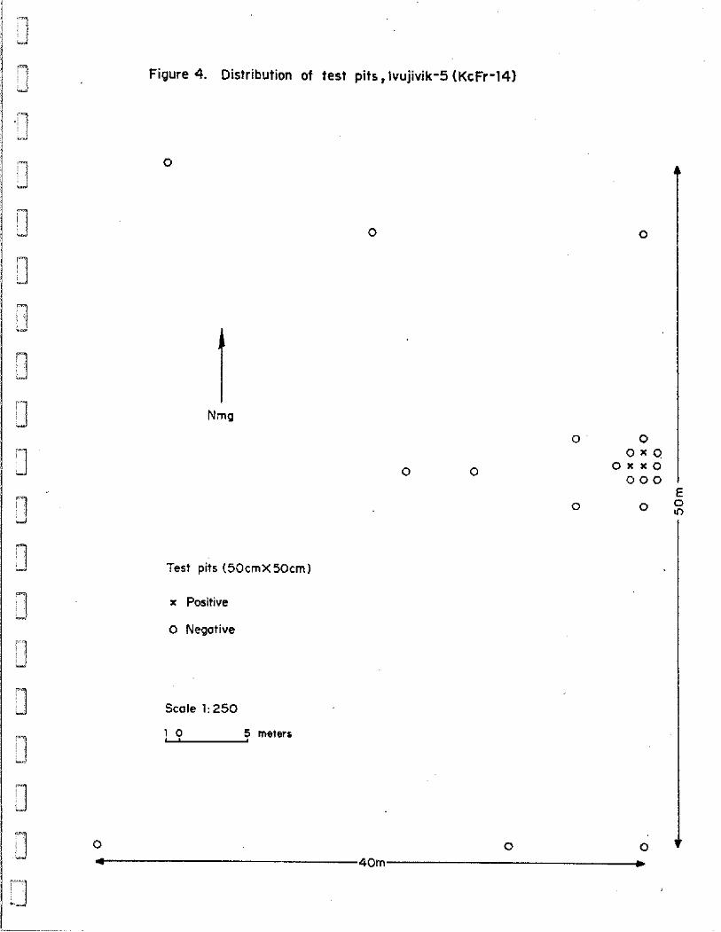
3
1 Figure 4. Distribution of test pits, lvujivik-5 (KcFr-14)
3
Test pits (50cmX50cml
x Positive
0 Negative
Scale 1: 250
1 0 S meters
9 0 A
1 0
9 I 1 1
0 0
1 0 x 0 o x x o
0 0 0
'"I E
0 d
0 5 :
1 3 3 1 Ll 0
0 0 0 (I
4 40m c
productively was minimal, only three (3) of the test pits proving
positive. Excluding several mussel shell fragments, neither
lithics, organic remains or structural features were recovered or
noted in any of the other test pits. Consequently, the extent of
the area occupied and the character of this occupation remain
undetermined.
The site stratigraphy consists of a comparatively thick
vegetation cover separated from underlying coarse sandy grave*-by
a thin dark brown organic soil layer. The thickness of the
vegetation cover varies between 10 and 15. The soil layer does not
exceed 2 cm in maximum thickness.
LIthic Specimens
Sampling of the site produced four (4) chert flakes
(Appendix B). The three (3) test pits yielding these specimens are
clustered within a 2 m2 area. The limited distribution and small
number of flakes may suggest a brief use of the area as a chipping
station. Also, the site elevation and the variety of chert
recovered suggest a Paleoeskimo cultural affiliation, either Pre-
Dorset or Dorset.
Cultural Affiliation: Dorset
Location
Geographic Co-ordinates:
U.T.M.: MAP: 35K/5 (1:50 000)
Altitude (m.a.s.1.): 28 - 35.50 Distance/Shoreline (m): 450
General Description
The Ivujivik-6 site occupies a narrow valley situated in
the northwestern section of the peninsula (Fig. 3). This valley
extends from the drained pond opposite the Pita site west-
southwest towards Nuvuk Harbour. Surface sediments are composed of
marine gravels and limited sandy deposits. A linear pond occurs in
the upper part of the valley.
As defined by observed occupational data, the site
extends from the mid to upper section of the valley, a distance of
about 200 m (Appendix J). Its maximum width is roughly 45 m. The
bordering rock valley slopes are moderate in inclination.
Site vegetation is variable. Spare mosses and lichens
intermixed with grasses and sedges occur on the drier deposits.
Wet areas are occupied by sphagnum colonies.
Sampling and Stratigraphy
Four (4) test pits, all of which were negative, were
excavated in or adjacent to habitation structures or cultural
features identified in the site. The stratigraphies recorded in
these pits consist of undifferentiated sandy gravels.
Habitation Structures
Two (2) circular tent rings were identified in the
Ivujivik-6 site. Structure A is located in the middle,:,of the
valley approximately 50 m west of the pond. Structure B is roughly
12 m north of the pond. Both of these tent rings are 4.00 m in
diametre.
Two (2) other possible tent rings are suggested by vague
circular alignments of rocks. Also, additional structures may be
indicated by a relatively dense scatter of rocks occuring in the
eastern extremity of the site.
Secondary Cultural Features
Two (2) features composed of two (2) parallel alignments
of rocks were noted in the western section of the site. These
features, separated by a distance of 4.5 m, are 2.30 m in length
by approximately 50 cm in width (see Photos 65 and 66). Both are
closely comparable to mid-passages observed in structures located
in several of the other sites inventoried during the survey.
However, no associated habitation remains were noted for either of
these features.
Lithic Specimens
Two (2) chert microblades, fifteen (15) chert flakes and
two (2) flakes in metabasalt were surface-collected immediately
northwest of the mid-passage-like features. The microblades, chert
varieties and elevation of this part of the site suggest a Dorset
occupation.
5.1.11 Ivujivik-7 (KcFr-13)
Cultural Affiliation: Undetermined Paleoeskimo
Location
Geographic Co-ordinates:
U.T.M.:
Altitude (m.a.s.1.):
Distance/Shoreline (m) :
MAP: 35K/5
25
120
General Description
The Ivu jivik-7 site is located some 200 m southwest of
Ivujivik, on the opposite slope of the low bedrock formation
bordering the village (Fig. 3). The locality is composed of
bedrock outcrops and sandy gravel deposits of variable extent. A
sparse moss-lichen vegetation sporadically covers the deposits.
The site was identified on the basis of several surface-
collected flakes. Neither habitation structures nor other cultural
features were observed in the locality. The spatial extent and
character of occupation of the locality remain, then,
undetermined.
Sampling and Stratigraphy
Surface collecting was followed by the excavation of two
(2) random test pits. The stratigraphic profiles in these pits,
both of which were sterile, consist of undifferentiated gravel
mixed with sand.
Lithic Specimens
Four (4) chert flakes were surface-collected in the
locality. The raw material recovered suggests a Paleoeskimo
occupation. While a Pre-Dorset affiliation may be indicated, the
altitude of the site suggests that a Dorset use of the locality is
more probable. ~ . . ~ . . .~~
5.2 Contemporary Activity Areas
The survey also resulted in the registration of three (3)
spatially discrete activity areas currently used by the population
of Ivujivik (Fig. 3). As summarized in Table 15, these activity
areas include a (primarily) beluga hunting station, a flensing and
butchering station and a summer camp locality. The principal
activities carried out in these areas, interpreted from observed
structures, features and associated remains, were confirmed during
conservations with various Inuit residents of the community.
Additional modern materials and manufactured goods (such
as isolated 45-gallon drums, an abandoned snowmobile and discarded
metal fox-traps) were noted throughout the entirety of the area
surveyed. These items, however, are indicative of a general and
overall use of the Ivujivik peninsula and surrounding waters by
the village residents.
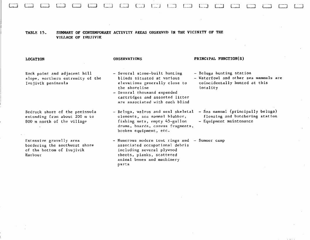
TABLE 15. SUMMARY OF CONTEMPORARY ACTIVITY AREAS OBSERVED IN THE VICINITY OF THE VILLAGE OF IWJIVIK
LOCATION OBSERVATIONS PRINCIPAL FUNCTION(S)
Rock point and adjacent hill slope, northern extremity of Ivujivik peninsula
the
Bedrock shore of the peninsula extending from about 200 m to 800 m north of the village
Extensive gravelly area bordering the southwest shore of the bottom of Ivujivik Harbour
- Several stone-built hunting - Beluga hunting station blinds situated at various - Waterfowl and other sea mammals are elevations generally close to coincidentally hunted at this the shoreline locality
- Several thousand expended cartridges and assorted litter are associated with each blind
- Beluga, walrus and seal skeletal - Sea mammal (principally beluga) elements, sea mammal blubber, flensing and butchering station iishing nets, empty 45-gallon - Equipment maintenance drums, boards, canvas Eragments, broken equipment, etc.
- Numerous modern tent rings and - Summer camp associated occupational debris including several plywood sheets, planks, scattered animal bones and machinery parts
5.3 Impact Mitigation
Consultation of airport development plans in the field
indicated that the following three ( 3 ) prehistoric sites were
located in construction areas:
the Meeus site, Areas A and B, situated directly in the
planned northeastern extension of the existing runway and
in two ( 2 ) suggested rock quarries scheduled for
explosive demolition;
. the Ivujivik-5 site, located in the proposed
southwestern extension of the airport runway;
the Ohituk site, occupying a suggested borrow-pit.
Mr. Denis Roy, archaeologist with the Service de
llEnvironnement of the Ministere des Transports du QuGbec, was
informed by telephone of the imminent destruction of these sites
during the second week of August. At this time, emergency salvage
excavations were recommended for the Ohituk site. Alternately, no
archaeological rescue of either the Meeus site or the Ivujivik-5
site was advised. The exclusion of the latter sites from the
proposed salvage project was based on the following
considerations:
. the feasibility of carrying out the extensive
excavations required within the projected construction
schedule;
. the considerable funding necessary to the execution of
such excavations;
. the assessed potential of the sites to produce data
significant to an improved archaeological understanding
of prehistoric Inuit occupations in Quebec as well as in
the Canadian Eastern Arctic.
For example, the scarce data recovered in the sampled
area of the Ivujivik-5 site tend to indicate that this locality is
of little or no archaeological importance. Salvage excavation of
the site as well as the funds required for such salvage are
considered as unwarranted.
The cost of salvaging the Meeus site A and B areas is
similarly prohibitive. These occupation areas are estimated to
cover a combined total of more than 25 000 m2. As demonstrated by
sampling results, cultural materials in these areas are not only
of low density but of sporadic distribution. Implicitly, then,
extensive salvage excavations would have been necessary in order
to recover data differing both statistically and qualitatively
from those collected earlier in the site. Moreover, the time
required for such salvage would have necessitated a delay in the
dynamiting of the bedrock hills bordering the site then scheduled
to begin in late August.
These circumstances were explained to Mr. Clgment
Tremblay, Office of the Deputy Minister, MinistSre des Transports
du Qugbec, who arrived in Ivujivik on 16 August. Mr. Tremblay was
accompanied by a party of government officials on an inspection
tour of the airport construction progress. This party included Mr.
Jean VEzinet, geomorphologist with the ministry, as well as Mr.
Roy.
Mr. Vgzinet's examination of the suggested gravel pit
occupied by the Ohituk site indicated that the quality and
quantity of gravel contained in this locality were insufficient
for construction purposes. Rejection of this gravel pit
consequently eliminated the necessity of salvage excavations in
the Ohituk site. Also, in order to prevent the inadvertart-
disturbance of the Meeus site area adjacent to construction zones
(i.e., Area C) and, additionally, of the Pita and Ivujivik-6
sites, it was proposed that this area and these sites be clearly
delineated.
The Municipal Council of Ivujivik was duly informed of
and consented to the implementation of the suggested mitigation
measures. Accordingly, rows of wooden stakes were set up along the
northern limit of the Meeus site Area C, the northeastern
extremity of the Ivujivik-6 site and the southeastern edge of the
Pita site. These rows are intended to prevent heavy equipment from
moving across these archaeological sites.
6.0 DISCUSSION
The archaeological inventory of the Ivujivik airport
development area and the surrounding environs resulted in the
discovery of seven (7) prehistoric sites. Also, four (4)
Paleoeskimo sites previously reported in the area were more
precisely defined. Though only briefly researched, the majority of
these site produced data of both substantive and theoretical
significance.
Firstly, survey results clarify the altitudinal
variability and principal physical characteristics of sites
occupied by prehistoric groups inhabiting the region through time.
For example, while Dorset sites occur between 16 and 34 m.a.s.1,
sites interpreted as Pre-Dorset occupations are situated between
32 and 51 m.a.s.1. These sites generally occupy flat to moderately
inclined, well-drained sandy gravel deposits associated with
vertical bedrock walls or ledges and in close proximity to fresh
water sources. Also, several habitation sites were found in
varieties of localities frequently excluded from archaeological
surveys in Arctic Quebec. Comparatively small gravel deposits on
hill slopes and boulder fields are cases in point.
Secondly, the number of the prehistoric sites inventoried
indicate a more intensive occupation of the vicinity than that
suggested by the available literature. Variability of Pre-Dorset
and Dorset site altitudes tend to suggest a lengthy temporal
duration for each of these cultures in the region. Moreover,
comparable altitudes recorded for several Pre-Dorset and Dorset
sites may indicate continuous Paleoeskimo occupation of
northwestern Ungava. A cultural continuum in excess of 2500 years
is implied.
Thirdly, structural remains identified in the Pre-Dorset
sites provide clarification not only of Early Paleoeskimo
habitation types but of the character of these occupations.
Preliminary consideration of the spatial relationships of
individual structures and of habitation clusters suggest repeated
occupation of these sites by numerically small groups composed,
theoretically, of several nuclear families. Variability of
habitation types in and between sites further suggest multi-
seasonal Pre-Dorset occupations.
As only a single tent ring is tentatively interpreted as
a possible Thule culture habitation, sites pertaining to these
later prehistoric groups are conspicuous by their absence in the
area surveyed. Historic Inuit sites are also generally lacking in
this area. These absences imply dissimilar Paleoeskimo and
Neoeskimo settlement-subsistence patterns in the region. However,
the large multiple family tent rings noted in the Ivujivik-3 site
indicate at least temporary occupation of the Ivujivik peninsula
by historic Inuit. The chronology of this or these occupations is
undetermined.
Finally, measures implemented in the field for the
protection of sites threatened by construction activities are to
be noted. As already discussed, the rejection of a suggested
gravel pit eliminated the necessity of carrying out emergency
salvage excavations in the Ohituk site. Measures designed to
prohibit vehicular access to the Pita and Ivujivik-6 sites and
Area C of the Meeus site also resulted from the survey. The
implementation of such impact mitigation measures through the
collaboration of the Municipal Council of Ivujivik and the
Ministere des Transports du QuCbec represents a precedent for the
development of cultural heritage resource management policies in
Northern Quebec Inuit territories.
The archaeological inventory carried out within the
context of the airport development project of the village of
Ivujivik produced data of significance to a better understanding
of cultural occupations in the region. Additionally, measures for
the protection of several archaeologically important prehistoric
sites endangered by construction activity were undertaken in the
field. Consequently, no immediate salvage excavations are
recommended for any of the archaeological sites inventoried during
the survey. However, in view of the preliminary results of the
survey, it is recommended:
. That systematic archaeological inventories be conducted
in the airport development areas planned for other
Northern Quebec Inuit municipalities.
The number of archaeological sites recorded in the
vicinity of Ivujivik and the assessed archaeological importance of
these sites illustrates the desirability of the recommended
surveys. More importantly, the implementation of measures for the
mitigation of construction impacts on sites in this municipality
clearly demonstrates the necessity of such surveys.
. That the recommended inventories be carried out well in
advance of planned construction activities.
This recommendation is forwarded in the interest of
allowing the coherent organization and adequate scheduling of
salvage projects for sites possibly threatened by airport
development in other municipalities. The brief period between the
survey and the scheduled dynamiting of quarries bordering the
Meeus site is a case in point. While the costs involved in the
salvage of this site would have been prohibitive in terms of
speculated data recovery, an earlier date for the beginning of the
survey would have allowed more extensive sampling of this site.
Efforts should be made to avoid similar circumstances in the
future.
. That the local populations as well as the councils of
the municipalities concerned be consulted during the
inventories suggested.
Several private collections of cultural materials were
made available for examination by residents of the village during
the course of the present survey. These collections, recovered
from sites on the Nuvuk and Digges Islands and on Manse1 Island,
include both Paleoeskimo and Neoeskimo materials. Information
concerning the location and physical characteristics of the sites
concerned was also provided by various individuals during the
examination of the collections. Recording of similar data
presumably available in other Northern Quebec Inuit communities
would complement the results of the proposed i~lventories. Such
information-gathering would further allow the more direct
participation of a larger number of local residents in the
archaeological research undertaken.
. That the erosion of the Ohituk site be monitored at
regular intervals.
Slumping and the lack of vegetation observed along the
bank of the western section of the 23 m terrace indicate that
erosion is ongoing in this portion of the site. Although the
rapidity of the processes are not readily apparent, either
stabilization efforts or salvage of the eroding bank may need to
be undertaken in the near future. The recommended monitoring of
the site could be carried out by an Inuit resident of Ivujivik and
involve the photography of the bank at 63011th intervals (i.e.,
early spring and end of summer beginning of autumn).
. That the community of Ivujivik be fully informed of the
results of the present survey and, in addition, be
allowed access to the lithic collections recovered for
educational purposes.
A considerable number of the Inuit residents of the
village of Ivujivik encountered during the course of the inventory
expressed a strong interest not only in survey results but also in
cultural heritage studies of relevence to the local population. It
is therefore proposed that illustrated summaries of the survey
results in Inuktittut and/or English be made available to the
community. It is further recommended that the artifact collections
recovered during the survey be made accessible to this community
in particular and to the Northern Quebec Inuit population in
general for display and educational purposes.
Survey field activities were carried out by Mr. Ian
Badgley, senior archaeologist of Amgnatech Inc., Mr. Edward Mesher
of Kuujjuaq and Mr. Jacques Brouard of the Ministere des
Transports du Qugbec. The report was written by Mr. Badgley. The
site plans and maps were reproduced by Madame Carmen Pelletier,
environmentalist with AmGnatech Inc., and by Mr. Richard Mailhot,
draftsman with the firm. Madame Andree Desautels prepared the
tables and photographic appendix. The report was typed by Madame
Dominique Saint-Germain.
1/ Ian Badgley, M.A. Archaeologist
AMENATECH
1984 Archaeological Potential Study of the Airport
Development Area, Ivujivik, Northern Quebec,
report presented to the Makivik Corporation,
Montreal, 48 pp.
AUDET, R.
1979 "Histoire d u caribou du Qu6bec-Labrador et
6volution des populations" in Dossier caribou, ed.
by F. Trudel and J. Huot, Recherches amgrindiennes
au Qdbec, Vol. IX, Nos. 1-2, pp. 17-28.
BOSTOCK, H.S.
1972 "Physiographic Subdivisions of Canada" in ~eology.
and Economic Minerals of Canada, ed. by R.J.W.
Douglas, Geological Survey of Canada, Economic
Geology Report No. 1, Department of Energy, Mines
and Resources, Ottawa, pp. 9-30.
ENV IRONNEMENT CANADA
1982 Dossier cartographique du Nouveau-Qu6bec et des
rggions adjacentes, Bureau de la Baie James et du
nord qu6b6cois.
HILLAIRE-MARCEL, C.
1979 I , Les mers post-glaciaires du Quebec: Quelques
aspects ." Doctoral thesis submitted to Universite Pierre et Marie Curie, Paris VI, Paris.
LEECHMAN, D. . . ~ . . . . .
1943 "Two New Cape Dorset sites", American ~nti~uity;
Vol. 4, pp. 363-377.
MCCART, P.J. and J.D. BESTE
1979 Aquatic Resources in the Northwest ~erritories,
Science Advisory Board of the Northwest Territories,
Yellowknife.
PLUMET, P. and I. BADGLEY
1980 Rapport prgliminaire des activitBs de terrain. Et6
1 9 7 9 , ms. deposited at the ministsre des Affaires
culturelles du QuBbec, QuBbec, 13 pp.
PREST, V.K.
1972 "Quaternary Geology", in Geology and Economic
Minerals of Canada, ed. by R.J.W. Douglas,
Geological Survey of Canada, Economic Mineral Report
No. 1 , Department of Energy, Mines and Resources,
Ottawa, pp. 675-764.
RICHARD, P.
1981 "Pal6ophytog6ographie post-glaciaire en Ungava par
l'analyse pollinique", Collection PalBo-QuBbec, no.
13.
SCIENCE ADVISORY BOARD OF THE NORTHWEST TERRITORIES
1980 Arctic Marine Mammals, Report No. 3 , Yellowknife.
STOCKWELL, C.H., J.C. MCGLYNN, R.F. EMSLIE, B.V. SANFORD, A.W.
NORRIS, J.A. DONALDSON, W.F. FAHRIG and K.L. CURRIE
1972 "Geology of the Canadian Shield" in Geology and
Economic Minerals of Canada, ed. by R.J.W. Douglas,
Geological Survey of Canada, Economic Geology,
Report No. 1, Department of Energy, Mines and
Resources, Ottawa, pp. 43-150.
TAYLOR, W.E., Jr.
1958 "Archaeological Work in Ungava, 1957", Arctic
Circular, Vol. X, No. 2, pp. 25-27.
1959 "Archaeological Work in Ungava and Manse1 Island",
The Arctic Circular, Vol. XI, No. 4, pp. 66-68.
1960 "Archaeological Work, Ivujivik and Mansel Island,
1959", The Arctic Circular, Vol. XIII, No. 1, pp. 1-
4.
1962 I, Pre-Dorset Occupations at Ivujivik in Northwestern
Ungava", in Prehistoric Cultural Relations between
the Arctic and Temperate Zones of North America, ed.
by J. Campbell, Arctic Institute of North America
Technical Paper 11, pp. 80-91.
1968 "The Arnapik and Tyara Sites: An Archaeological . . . . ~ ~ . . .
Study of Dorset Culture Origins", Society for ~ . ~ . . . , ~ . . ~ . . .
American ~rchaeolo~~ Memoir 22, American Antiquity,
Vol. 33, No. 4, Part 2.
1 1 VEZINET, M.
1982 "Occupation humaine d e 1'Ungava. Perspective . . , . - . . .. .
ethnohistorique et Ccologique", collection Paliio-
QuCbec, no. 14, U.Q.A.M., MontrCal.
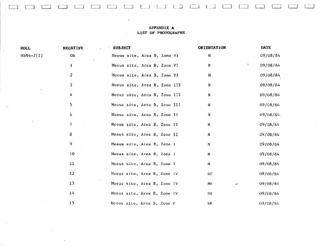
APPENDIX A LIST OF PIIOTOGKAPHS
ROLL NEGATIVE
NB84-2( 1 ) 0 A
1
2
3
4
5
6
7
8
9
10
11
1 2
13
14
15
SUBJECT
Meeus s i t e , Area B, Zone V I
Meeus s i t e , Area B , Zone V I
Meeus s i t e , Area B , Zone V I
Mceus s i t e , Area B, Zone I11
Meeus s i t e , Area B , Zone 111
Meeus s i t e , Area B , Zone I11
Meeus s i t e , Area B , Zone I1
Meeus s i t e , Area B , Zone 11
Meeus s i t e , Area B , Zone I1
Meeus s i t e , Area B , Zone I
Meeus s i t e , Area B, Zone 1
Mecus s i t e , Area B , Zone I
Mceus s i t e , Area B , Zone I V
Mefus s i t e , Area B , Zone I V
Meeus s i t e , Area B , Zone IV
Heeus s i t e , Area B , Zone V
ORIENTATION
N
N
N
N
N
DATE
09/08/84
09/08/84
09/08/84
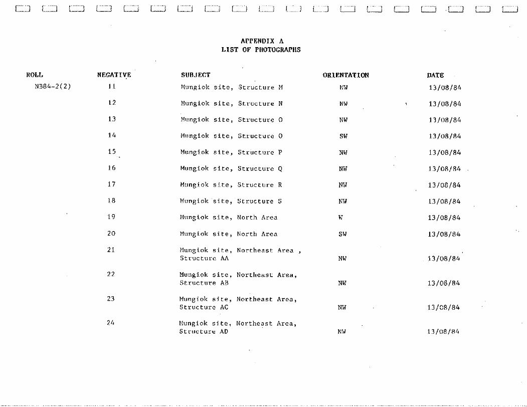
ROLL NEGATIVE
NB84-2 ( 2 ) 1 1
APPENDIX A L I S T O F PIIOTOCRAPIIS
SUBJECT
Mungiok s i t e , S t r u c t u r e M
Mungiok s i t e , S t r u c t u r e N
Mungiok s i t e , S t r u c t u r e 0
Mungiok s i t e , S t r u c t u r e 0
14ungiok s i t e , S t r u c t u r e P
Mungiok s i t e , S t r u c t u r e Q
Mungiok s i t e , S t r u c t u r e R
Mungiok s i t e , S t r u c t u r e S
Mungiok s i t e , Nor th Area
Mungiok s i t e , North Area
Mungiok s i t e , N o r t h e a s t Area , S t r u c t u r e AA
MungLok s i t e , N o r t h e a s t Area , S t r u c t u r e AB
Mungiok s i t e , N o r t h e a s t Area , S t r u c t u r e AC
Mungiok s i t e . N o r t h e a s t Area , S t r u c t u r e AD
ORIENTATION
NW
DATE
1 3 / 0 8 / 8 4
APPENDIX A L I S T OF PIIOTOCRAPIIS
ROLL NB84-2( 2)
NEGATIVE
2 5
SUBJECT
Mungiok site, Northeast Area, Structure AE
Mungiok site, Northeast Area, Structure AF
Mungiok site, Northeast Area, Structure AG
Mungiok site, Northeast Area, Structure AH
Mungiok site, Northeast Area, Structure A1
Mungiok site, Northeast Area, Structure AJ
Mungiok site, Northeast Area, overview
ORIENTATION
NW
Mungiok site, Northeast Area, overview NW
Ivujivik-1 Overview SW
Ivujivik-1 Overview SW
Ivujivik-1, Area A, Structure A S
Ivujivik-1, Area A, Structure A NW
DATE
APPENIIIX A L I S T OF P l l O T O C W l l S
ROLL
NB84-2(3)
NEGATIVE
2A
3A
4A
5A
6A
7A
8A
9A
Sl lBJECT
Ivujivik-3, Structure A
Ivujivik-3, Structure B
Ivujivik-3, Structure C
Ivujivik-3, Hearth
Ivujivik-3, Structure D
Tvujivik-3, Structure E
Ivujivik-3, Structure F
Ivujivik-3, Structure G
Ivujivik-3, Structure H
Ivujivik Harbour
Ivujivik Harbour
Ivujivik-4, Structure A
Ivujivik-4, Structure B
Ivujivik-4, Structure C
Ivujivik-4, Bone and rock concentration
ORIENTATION
SSE
SSE
DATE
14/08/84
14/08/84
14/08/84
14/08/84
14/08/84
14/08/84
14/08/84
14/08/84
APPENDIX A LIST OF PIIOTOGRAPIIS
ROLL
NB84-2(3)
NEGATIVE
17A
18A
SUBJECT ORIENTATION DATE
Ivujivik-4, Structure F NE 14/08/84
Ivujivik-4 rock concentration (several structuressuggested) NE 14/08/84
Ivujivik-4, overview SW 14/08/84
Ivujivik-4, overview S 14/08/84
Meeus site, Zone 11, east wall profile and hearth E
Meeus site, Zone 11, east wall profile and hearth E
Ivujivik-1, Area C, Structure CA NW
Ivujivik-1, Area C, Structure CA NE
Ivujivik-I, Area C, cache 1 SE
Ivujivik-1, Area C, Hearth NW
Ivujivik-1, Area C , cache 2 S
Ivujivik-1, Area C, Structure CB W
Ivujivik-1, Area B NE
Ivujivik-1, Area B NE
APPENDIX A LIST OF PIIOTOGRAPIIS
ROLL NEGATIVE
NB84-2(3) 31A
SUBJECT ORIENTATION DATE
Ivujivik-1, Area B, Structure BA, Entrance NW
Ivujivik-1, Area B , Structure BA, Entrance SSE
Ivujivik-1, Area B, Structure BB SSE 15/08/84
3 4A Ivujivik-1, Area B, Boulder alignment S 15/08/84
3 5A
36A
end of roll
~884-2(4) 1A
2A
3A
4A
5A
6A
7A
Ivujivik-1, Area R, Structure BC
Ivujivik-1, Area B, Structure BD
Ivujivik-1, Area B, cache
Ivujivik-1, Area A, South section, Structure L
Ivujivik-1,Area A, North section, Structure J
Ivujivik-1, Area A, North section, Structure I
Ivujivik-1,Area A, North section, Structure H
Ivujivik-1,Area A, North section Structure H
lvujivik-1,Area A, North section, Structure I
Ivujivik-1, Area A, North section, Structure J
ROLL NEGATIVE
NB84-2(4) 8A
APPENDIX A LIST OF PllOTOCRAPllS
SUBJECT ORIENTATION DATE
Ivujivik-1, Area A, North section, Structure G NE
Ivujivik-1, Area A , North section, Structure F NE
Ivujivik-1, Area A, North section, Structure F N
Ivujivik-1, Area A, North section, Structure E NE
Ivujivik-1, Area A, North section, Structure C W
Ivujivik-1, Area A, North section, Structure B NW
Ivujivik-1, Area A, North section, Structure D NE
Ivujivik-5, Environment W
Ivujivik-5, Environment SW
Ivujivik-5, Environment SSW
Ivujivik-5 from Ivujivik-2
Ivujivik-2, Structure A
Ivujivik-2, Structure B
Ivujivik-2, Structure C
APPENDIX A LIST OF PIiOTOGKMllS
ROLL NEGATIVE
NB84-2(4) 2 2A
SUBJECT
Ivujivik-2, Structure D
Ivujivik-2, Structure E
Ivujivik-2, Structure F
ORIENTATION
N E
DATE
16/08/84
1 25A Ivujivik-2, overview NE 16/08/84
Pita site, Structure H
Pita site, overview
Pita site, Structure A
Pita site, Structure? B
Pita siLe, Structure C
Pita site, Structure D
Pita site, Structure C
Ivujivik-6, Rock alignments 1
Ivujivik-6, Rock alignments 2
Ivujivik-6, Structure A
Meeus site, Area B from Area C
Ivujivik-7, overview
5 Meeus site, Area C, Structure A ESE 18/08/84
f Meeus site, Area c, Structure B NW 18/08/84
NEGATIVE
9
APPENDIX A LIST OF PllOTOGKAPllS
SUBJECT ORIENTATION
Meeus s i t e , Area C , S t r u c t u r e C N W
Meeus s i t e , Area C , S t r u c t u r e D N W
Meeus s i t e , Area C , S t r u c t u r e E N W
Meeus s i t e , Area C , S t r u c t u r e F S
Meeus s i t e , Area C , S t r u c t u r e G NE
Meeus s i t e , Area C , S t r u c t u r e H S E
Meeus s i t e , Area C , S t r u c t u r e I Hearth N
Meeus si-te, Area C , S t r u c t u r e J S E
Meeus s i t e , Area C , S t r u c t u r e K E
Meeus s i t e , Area C , overview S E
Ohituk s i t e , Western t e r r a c e N
Ohituk s i t e , Western t e r r a c e S
Ohituk s i t e , Western t e r r a c e , eroding bones
Ohituk s i t e , Western t e r r a c e , e ros ion SE
Ohitulc s i t e , Western t e r r a c e , SW
DATE
18/08/84
18/08/84
18/08/84
18/08/84
ROLL
NB84-2 (5)
NEGATIVE
39
APPENDIX K LIST OF FllOTOGRMllS
SUBJECT
Ohituk.site, Western terrace, eroding flakes
Ohituk site, .overview
Ohituk site, Eastern terrace, Structure A
Ohituk site, Eastern terrace, Structure B
Ohituk site, Eastern terrace, Structure C
Ohituk site, Eastern terrace, Structure D
ORIENTATION DATE
t 18/08/84
18/08/84
18/08/84
18/08/84
APPENDIX B. CATALOGUE OF LTTHIC SPECIMENS COLLECTED IN ARCHAEOLOGICALSITES INVENTORIED, IWJIVIK, NORTHERN QUEBEC.
1. MEEUS SITE (KcFr-4) a) WORKED OR USED SPECIMENS
CLASS
End blade
End blade
Triangular End blade
Triangular End blade
Stemmed end blade
Stemmed end blade
Stemmed end blade
Stemmed end blade
Micropoint
Micropoint
End scraper
Perforator
Burin
Burin
Burin
Burin
PROVENIENCE
Area A, Surface
Area B, Surface
Area B, Surface
Area B, Test Zone I1
Area B, Test Zone TI
Area B, Test Zone I1
Area B, Test Zone I1
Area B, Test Zone I1
Area B, Test Zone 11
Area C, Surface
Area B, Test Zone I1
Area B, Test Zone I1
Area B, Surface
Area B, Test Zone IT
Area B, Test Zone I1
Area B, Test Zone 11
DESCRIPTION
-Distal extremity
-Denticulated, lateral fragment
-Denticulated; distally and lateraliyincomplete
-Latero-proximal fragment
-Stem fragment; unifacial
-Stem fragment; bifacial
-Stem fragment; bifacial
-Distally and proximally incomplete
-Laterally incomplete
-Unifacial
-Partially retouched
-Partially bifacial
-Complete
-Laterally incomplete
RAW MATERIAL
Chert I/'
2 Chert v'
3 Milky quartz !,
./ Chert J
" Chert i/ ( Chert
3 Chert
,Chert J
-/ Chert J
:.:: Milky quartz
Quartz crystal v'
'.?Chert w
,;? Chert v
.'" Chert il
'~< Chert /
!:< Chert J
CLASS
Bur in
Bur in
Bur in
Bur in s p a l l
Bur in s p a l l
Bur in s p a l l
Bur in s p a l l
Bur in s p a l l
Bur in s p a l l
Bur in s p a l l
Bur in s p a l l
Bur in s p a l l
Bur in s p a l l
Bur in s p a l l
Bur in s p a l l
Bur in s p a l l
Bur in s p a l l
Bur in s p a l l
Bur in s p a l l
Bur in s p a l l
Bur in s p a l l
Bur in s p a l l
PROVENIENCE
Area B , T e s t Zone I1
Area B , T e s t Zone 111
Area B, T e s t Zone I11
Area B , T e s t Zone I1
Area B , T e s t Zone I1
Area B , T e s t Zone I1
Area B , T e s t Zone I1
Area B , T e s t Zone I1
Area B , T e s t Zone I1
Area B , T e s t Zone I1
Area B , T e s t Zone I1
Area B , T e s t Zone I1
Area B , T e s t Zone I1
Area B , T e s t Zone I1
Area B , T e s t Zone I1
Area B , T e s t Zone I1
Area B , T e s t Zone I1
Area B , T e s t Zone I1
Area B, T e s t Zone I1
Area B , T e s t Zone I1
Area B , T e s t Zone I11
Area B, T e s t Zone I V
DESCRIPTION RAW MATERIAL
-On f l a k e ; l a t e r a l l y incomple te 17 C h e r t L"
-Complete ,$ C h e r t
-On f l a k e ; l a t e r a l l y incomple te ,* Cher t
~ , i C h e r t .. -.
,I Cher t , '
,;.z Cher t ,.
:! . C h e r t "-
::'?Chert " 2-
d 2< C h e r t
J ,!q Cher t
::Chertc' S,'
: T C b e r t
-"Chert - i/ r;) Cher t
:f2 C h ~ r t "
7; Chert "'
;? Chert'&
:;>I Chert !./
CLASS
Bur in s p a l l
Blade
Blade
Microblade
Microblade
Microblade
Microblade
Microblade
Microblade
Microblade
Microblade
Microblade
Microblade
Bur in s p a l l
Bur in s p a l l
Bur in s p a l l
Blade
Blade
Microblade
Microblade
Microblade
Microblade
PROVENIENCE
Area B , T e s t Zone I V
Area B , T e s t Zone I V
Area C , S u r f a c e
Area B , S u r f a c e
Area B , T e s t Zone I1
Area B , T e s t Zone I1
Area B , T e s t Zone I1
Area B , T e s t Zone I1
Area A , T e s t Zone I1
Area B, T e s t Zone I1
Area B . T e s t Zone I1
Area B , T e s t Zone I1
Area B , T e s t Zone I1
Area B , T e s t Zone I 1 T
Area B , T e s t Zone I V
Area B , T e s t Zone I V
Area B , T e s t Zone I V
Area C , S u r f a c e
Area B , S u r f a c e
Area B , T e s t Zone I1
Area B , T e s t Zone I1
Area B , T e s t Zokie I1
DESCRIPTION
-Used
-Retouched; d i s t a l l y incomple te
- D i s t a l l y incomple te
-Comp Lete
-Comp 1 e t e
- D i s t a l l y incomple te
- D i s t a l l y incomple te
- D i s t a l f r agment ; r e t o u c h e d
-Mesial f r agment ; r e t o u c h e d
-Mesial f r a g m e n t ; u s e d
-Mesial f ragment
-Proximal ly i n c o m p l e t e
-Retouched; d i s t a l l y incomple te
- D i s t a l l y incomple te
-Complete
- D i s t a l l y incomple te
RAW MATERIAL
if'* Cher t
.iq Cher t
43 Cher t w' - ~ c c h e r t
Cher t
'.?'Chert
"'.Chert
"7 Cher t
#,?Chert ,,
.,',-Chert
,;,, Cher t
"I Cher t .. ~ ~.
." Cher t
.<7 Cher t
6'': Chert
:".; Cher t
::: Cher t
Cher t L/
Cher t ..,*z..
fi;' c h e r t . , $?Cher t
CLASS
Microblade
Microblade
Microblade
Microblade
Microblade
Microblade
Microblade
Microblade
Microblade
Retouched f l a k e
Retouched f l a k e
Retouched f l a k e
Retouched f l a k e
Used f l a k e
Used F lake
Used Elake
Used f l a k e
Used f l a k e
Used f l a k e
Used f l a k e
PROVENIENCE
Area B , T e s t Zone I1
Area B , T e s t Zone I1
Area B , T e s t Zone I1
Area B , T e s t Zone I1
Area B , T e s t Zone I1
Area B , T e s t Zone I1
Area B , T e s t Zone I1
Area B , T e s t Zone I V
Area B , T e s t Zone I V
Area B , S u r f a c e
Area B , T e s t Zone I1
Area B , T e s t Zone I1
Area B , T e s t Zone I11
Area A , S u r f a c e
Area B , S u r f a c e
Area B , S u r f a c e
Area B , T e s t Zone I1
Area B , T e s t Zone I1
Area B , T e s t Zone 111
Area C , S u r f a c e
DESCRIPTION RAW MATERIAL
- D i s t a l l y incomple te ? Cher t
- D i s t a l f ragment ; r e touched & z C h e r t
-Mesial f ragment ; r e touched L ? Cher t
-Mesial f r a g m ~ n t ; used LL/ Cher t
-Mesial f ragment . L s Cher t
-Proximal ly incomple te &(I, Chert
- L a t e r a l l y incomple te ,< 27 Cher t
-Proximal f ragment :. ,, / i Cher t
-Proximal ly and d i s t a l l y i n c o m p l e t e c ? Cher t
7 : Cher t
2, Cher t r/
;?Chert 'J"
-,3 Cher t
Ti.' Chert
3.5 Cher t
?!:.: Chert
.?:'Chert w/
;.?Chert ,L.'
-"/Chert
2% Chert
b) DETRITUS
CATEGORY
F l a k e s and f l a k e f ragments
Debr i s
PROVENIENCE
Area A . S u r f a c e
Area B , S u r f a c e
Area B , T e s t Zone I1
Area B , T e s t Zone I11
Area B , T e s t Zone I V
Area B , T e s t Zone V I
Area C , S u r f a c e
Quarry
Area A , S u r f a c e
Area R, S u r f a c e
Area C , S u r f a c e
Quarry
RAW MATERIAL
Chert
Cher t Milky q u a r t z Quar tz c r y s t a l
Cher t
Cher t Quar tz c r y s t a l
Cher t Milky q u a r t z
Cher t
Cher t Milky q u a r t z Quar tz c r y s t a l
Quar tz c r y s t a l
Cher t
C h e r t
Milky q u a r t z
Quar tz c r y s t a l
TOTAL
MlMBER OF SPECIMENS
APPENDIX B
2. MUNGIOK SITE (KcFr-7)
a) WORKED OR USED SPECIMENS
CLASS
Triangular end blade
Stemmed end blade
Stemmed knife
End scraper
Concave side scraper
Perforator
Burin
Burin spall
Burin spall
Burin spall
Blade
Microblade
Microblade
Microblade
Microblade
Microblade
PROVENIENCE
Northeast Area, Surface
Northeast Area. Surface
Structure K, Test 1
Structure K, Test 1
Structure K, Test 1
Northeast Area, Surface
Northeast Area, Surface
Northeast Area, Surface
Structure J, Test 2
Structure J, Test 2
Structure K, Test 1
N0rt.h Area, Surface
North Area, Surface
Northeast Area, Surface
Structure k, Test I
Structure J, Test 2
DESCRIPTION RAW MATERIAL
-Proximo-located fragment 4 Chert -In two fragments; distally s Chert incomplete
-Proximally incomplete 3 Chert -On flake ~i chert
-On blade; convex edge ; Chert retouched as knife
-Incipient notch; complete : Quartz crystal -Complete r Chert
, Chert
61 Chert
Chert [ ', -Use wear; complete :,' Chert
-Distally incomplete 8 Chert
-Retouched; distally :':Chert incomplete
-Distally and proximally ;'- Chert incomplete
-Mesial fragment Quartz crystal
-Mesial fragment Chert : i,,
1 a c a ~ u u L ~ f x 7
CLASS PROVENIENCE DESCRIPTION RAW MATERIAL
Retouched flake
Retouched flake
Retouched flake
Structure K, Test 1
North Area, Surface
North Area, Surface
12 Chert
15' Chert
, d Chert
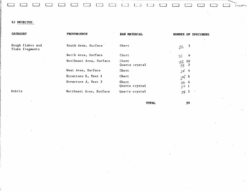
b) DETRITUS
CATEGORY
Rough flakes and flake fragments
E 1 Y
i 1 Debris 1 s
1 I ! ! 1 1 I
PROVENIENCE RAW MATERIAL
South Area, Surface Chert
North Area, Surface Chert
Northeast Area, Surface Chert Quartz crystal
West Area, Surface Chert
Structure K, Test 1 Chert
Structure J, Test 2 Chert Quartz crystal
Northeast Area, Surface Quartz crystal
TOTAL
NUMBER OF SPECIMENS
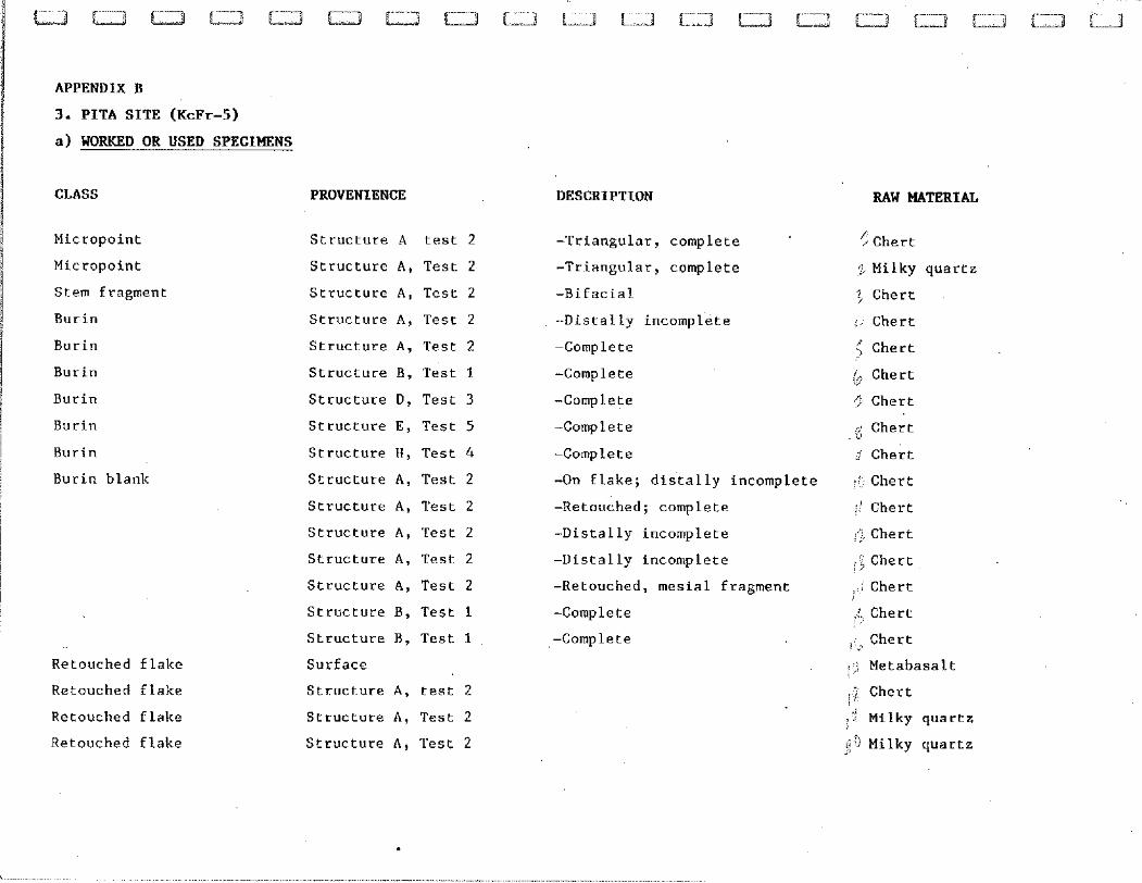
APPENDIX B
3. PITA SITE (KcFr-5)
a) WORKED OR USED SPECIMENS
CLASS PROVENIENCE
Micropoint
Micropoint
Stem fragment
Burin
Burin
Burin
Burin
Burin
Burin
Burin blank
Retouched flake
Retouched flake
Retouched flake
Retouched flake
Structure A test 2
Structure A , Test 2
Structure A , Test 2
Structure A , Test 2
Structure A , Test 2
Structure B, Test I
Structure D, Test 3
Structure E, Test 5
Structure H, Test 4
Structure A , Test 2
Structure A , Test 2
Structure A , Test 2
Structure A , Test 2
Structure A , Test 2
Structure B, Test 1
Structure B, Test 1
Surface
Structure A , test 2
Structure A, Test 2
Structure A , Test 2
DESCRIPTION
-Triangular, complete
-Triangular, complete
-Bifacial
-Distally incomplete
-Complete
-Complete
-Complete
-Complete
-Complete
-On flake; distally incomplete
-Retouched; complete
-Distally incomplete
-Distally incon~plete
-Ketouched, mesial fragment
-Complete
-Complete
RAW MATERIAL
<Chert
: Milky quartz '$ Chert
i.' Chert
< Chert /, Chert C
r/ Chert
: Chert
i Chert
,i: , . Chert
,:: Chert
a ^ Chert * j ,2 Chert , I ,;j Chert
Chert :,
,: Chert , ,;
! > Metabasalt
Chert
1 8 Milky quartz $9 Milky quartz
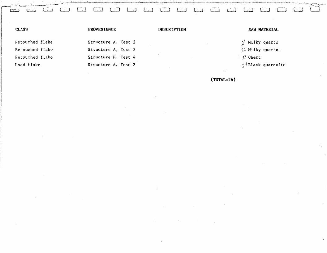
CLASS
Retouched flake
Retouched flake
Retouched flake
Used flake
PROVENIENCE
Structure A, Test 2
Structure A, Test 2
Structure H, Test 4
Structure A, Test 2
DESCRlPTION RAW MATERIAL
J / Milky quartz
1" Milky quartz
2- Chert
Black quartzite
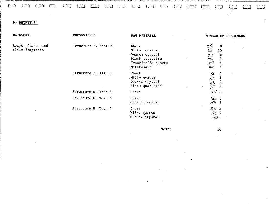
b) DETRITUS
CATEGORY
Rougt flakes and flake Fragments
PROVENIENCE
Structure A, Test 2
Structure B. Test 1
Structure D, Test 3
Structure E , Test 5
Structure H, Test 4
RAW MATERIAL
Chert Milky quartz Quartz crystal Black quartzite Translucide quartz Metabasalt
Chert Milky quartz Quartz crystal Black quartzit@
Chert
Chert Quartz crystal
Chert Milky quartz Quartz crystal
NUMBER OF SPECIMENS
TOTAL
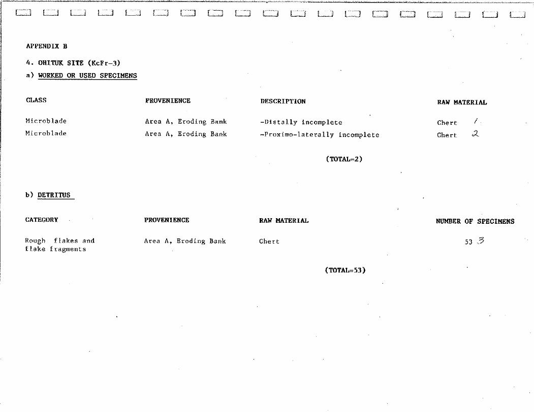
APPENDIX B
4. OHITUK SITE (KcFr-3)
a) WORKED OR USED SPECIMENS
CLASS
Microblade
Microblade
PROVENIENCE
Area A, Eroding Bank
Area A, Eroding Bank
DESCRIPTION
-Distally incomplete
-Proximo-laterally incomplete
b) DETRITUS
CATEGORY
Rough flakes and flake fragments
PROVENIENCE
Area A , Eroding Bank
RAW MATERIAL
Chert
RAW MATERIAL
Chert 1
Chert a
NUMBER OF SPECIMENS
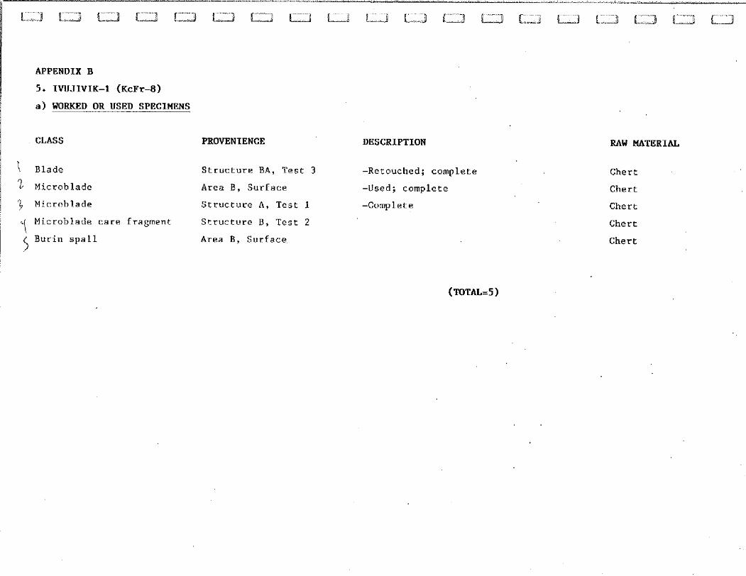
APPENDIX B
5. IWJIVIK-1 (KcFr-8)
a) WORKED OR USED SPECIMENS
CLASS PROVENIENCE
1 Blade Structure BA, Test 3
1 Microblade Area B, Surface
3 Microblade Structure A, Test 1
'I Microblade care fragment Structure B, Test 2
5 Burin spall Area B, Surface
DESCRIPTION
-Retouched; complete
-Used; complete
-Complete
RAW MATERIAL
Chert
Chert
Chert
Chert
Chert
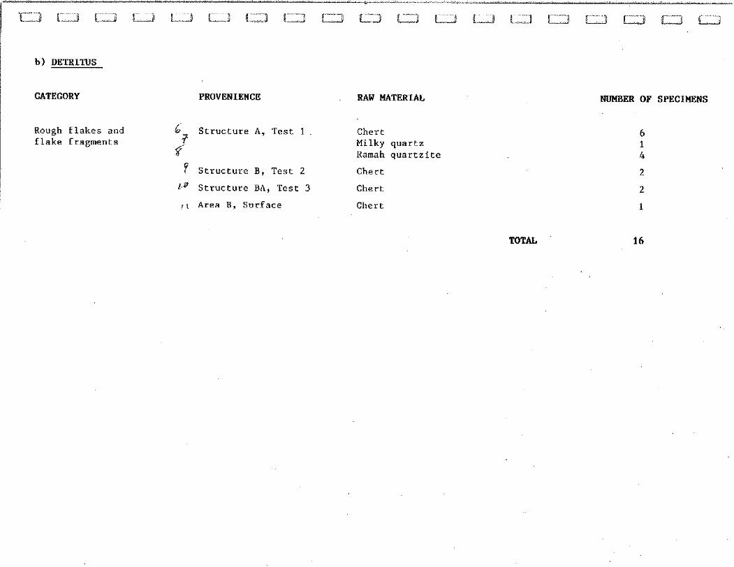
b) DETRITUS
CATEGORY PROVENIENCE RAW MATERIAL
Rough flakes and 6 Structure A , Test 1 i"
Chert flake fragments
2 Milky quartz Ramah quartzite
? Structure B, Test 2 Chert
L B Structure BA, Test 3 Chert
) I Area B, Surface Chert
NUMBER OF SPECIMENS
MTAL 16
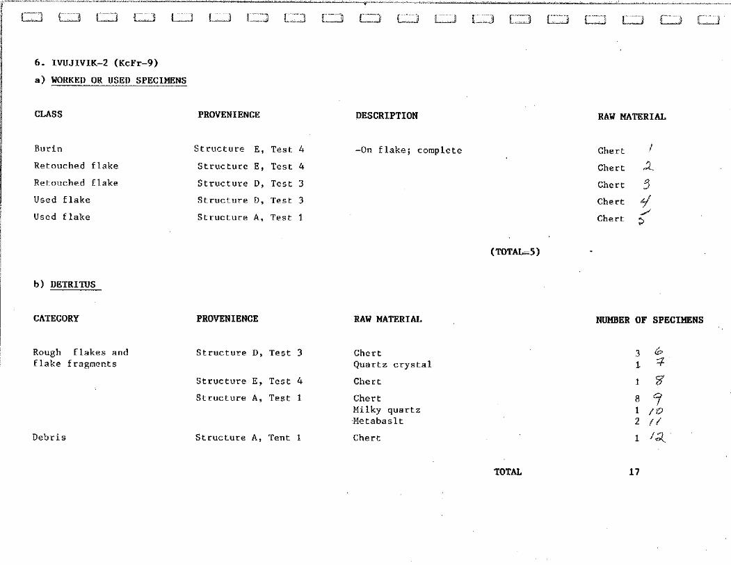
6. IWJIVIK-2 (KcFr-9)
a) WORKED OR USED SPECIMENS
CLASS PROVENIENCE
Burin
Retouched flake
Retouched flake
Used flake
Used flake
Structure E, Test 4
Structure E, Test 4
Structure D, Test 3
Structure D, Test 3
Structure A, Test 1
I I
b) DETRITUS
i 1 CATEGORY
Rough flakes and flake fragments
Debris
PROVENIENCE
Structure D, Test 3
Structure E, Test 4
Structure A. Test 1
Structure A , Tent 1
DESCRIPTION
-On flake; complete
RAW MATERIAL
Chert Quartz crystal
Chert
Chert Milky quartz Metabaslt
Chert
RAW MATERIAL
Chert
Chert 2. Chert 3 Chert $/ I
Chert a
NUMBER OF SPECIMENS
TOTAL 17
a) WORKED OR USED SPECIMENS
CLASS PROVENIENCE
( Retouched flake Structure A, Test 1
! I I
b) DETRITUS
CATEGORY
Rough flakes and flake fragments
PEOVENIENCE
Structure A, Test 1
Structure C, Test 2
DESCRIPTION RAW MATERIAL
RAW MATERIAL
Chert
Chert
TOTAL
NUMBER OF SPECIMENS
DETRITUS
CATEGORY
Rough Elakes and flake fragments
PROVENIENCE
Test 1
Test 2
Test 3
RAW MATERIAL
Chert
Chert
Chert
TOTAL
NUMBER OF SPECIMENS
-" r ~ ~ ~ ] ~ ~ ~ ~ ~ ~ L - ~ < ~ ~
9. IWJIVIK-6 (KcFr-12)
a) WORKED OR USED SPECIMENS
I I CLASS i
Microblade
Microblade
b) DETRITUS
PROVENIENCE
Surface
Surface
CATEGORY PROVENIENCE
DESCRIPTION RAW MATEBIAL
-Used; distally incomplete. Chert
-Complete Chert 2
RAW MATERIAL NUMBER OF SPECIMENS
Rough flakes and Surface Chert 15 3 flake fragments Metabasalt 2 f(
TOTAL i i
10. IWJIVIK-7 (KcFr-13)
DETRITUS
CATEGORY PROVENIENCE RAW MATERIAL NUMBER OF SPECIMENS
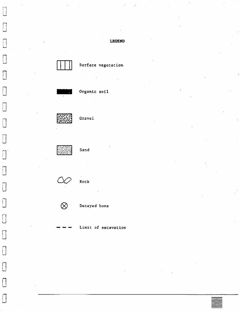
3 - Organic soil