Embed Size (px)
Citation preview

GeoEvent Server:Best Practices
Frank RobertsDirector of IT Services, Innovate
Adam MollenkopfReal-Time & Big Data GIS Capability Lead, Esri
@amollenkopf
Suzanne FossReal-Time & Big Data Product Engineer, Esri
@sfoss_esri

1
2
3
4
5
6
Agenda
Innovate: one-stop real-time air monitoring
ingestion & analytics
dissemination & visualization
storage
resilience & scalability
deploying at a massive scale
Innovate1 one-stop real-time air monitoring

INNOVATE!, Inc.AMCO Chemical Superfund Site
One-Stop Real-Time Air Monitoring
February 14, 2017

1
2
3
4
AGENDA
About Us
Big Data, Dig Deep
Beware of the Quirks
From the old, come the new

Innovate is a geographically diverse 8(a) woman-minority owned company, with a primary officelocation at the Ronald Reagan Building. Two primaryservice areas have garnering multiple awards forinnovation and partnership:
• Geospatial Solutions
• Information Technology
Awards include:
2014 EPA Mason Hewitt Award for Excellence,EnviroAtlas Application
2012 EPA Outstanding 8(a) Small Business of the Year
2010 EPA/CIO Award for Innovation, GeoDataGateway
ABOUT US
1

Ground SensorsMC2
OTIE Scribe
MC2 Scribe
Viper
Field/ Analytical Collection
Data Logging
Data Logging
Publish
Publish
Publish
EDMS
MC2 Database
AMCOScribe
Replication
OTIE
AMCO Web
Interface
Web Server
EPA RPM
Public
EPA Start
Inte
rnet
Bro
wse
rs
Subscription
Merged AMCO Scribe
R9 Scribe Replication
at R9ArcServer
AMCO Service
R9 Scribe/Viper
Replication at ER Cloud
EPA GIS Center Subscription
(On ER Cloud) (On Site at R9)
Air QualityViper OData Feed
Scribe.Net
What• Monitor the site• Provide status updates
(public and internal)
Why• Track cleanup progress• Ensure public safety
How• Harness the beast by any
means necessary(But use existing EPA tools)(But do it in a map)(That we can open anywhere)
(Include a unicorn)
Big Data, No Problem

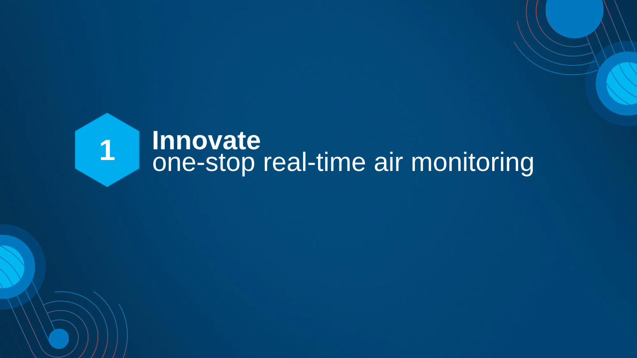
Deep in the Data…Identify the required objects in the JSON structure
Deeper in the Data…Data structure dictates Input requirements
• Select directly into CurrentReadings object
• Create a new GeoEvent Definition
• Build Geometry from Fields (Lat/Long)

GeoEvent Definitions
Use your Input Connector to create a GeoEvent Definition, then create a copy and tweak as necessary for the output
THEN create tables/feature classes in the database according to the definition
1
2
3
Assign tags to the output definition
Feature classes are flat – don’t give them hierarchical data

GeoEvent Services

Putting points on the mapMove from GeoEvents to a fully integrated Story Map with live data

Logs don’t always tell the whole story!Where’s the data?
In’s and Out’s go up, but no data in the database?
Use a text or json output to test your processorsand filters…
- See what you expect?
- Are datatypes correct?

Time Zone Time Warp
Next… Find the most recent reading from each sensor and publish as a feature class…
…but beware of time zones.
Sensor time ≠ Database Server time ≠ User time
• Set Windows tasks to delete old data (not GeoEvents)
• Convert feature class to UTC so AGOL popup displays is correct

Value Added
Use the ArcGIS Online tools we have... Build only the tools we don’t…

Value Added
https://epa.maps.arcgis.com/apps/MapSeries/index.html?appid=2e0a0e3d5cc041feb0c19d9f04327bcb

Quick Links
AMCO OSC:
https://www.epaosc.org/site/site_profile.aspx?site_id=5215
AMCO Story Map:
https://epa.maps.arcgis.com/apps/MapSeries/index.html?appid=2e0a0e3d5cc041feb0c19d9f04327bcb
(requires a GeoPlatform login)
AMCO Graphing Site:
r9.ercloud.org/AMCO
VIPER:
https://viper.ert.org/DeploymentManager/About.aspx
Scribe:
https://www.epaosc.org/site/site_profile.aspx?site_id=1812
More information about Esri GeoEvents:
http://www.esri.com/software/arcgis/arcgisserver/extensions/geoevent-extension

1
2
3
4
5
6
Agenda
Innovate: one-stop real-time air monitoring
ingestion & analytics
dissemination & visualization
storage
resilience & scalability
deploying at massive scale

ingestion & analytics2

you can create
your own
connectors
Ingestionuse an existing input connector
GeoEvent Server
Inp
uts
Ou
tpu
ts
GeoEvent Services
Poll an ArcGIS Server for Features
Poll an external website for GeoJSON, JSON, or XML
Receive Features, GeoJSON, JSON, or XML on a REST endpoint
Receive RSS
Receive GeoJSON or JSON on a WebSocket
Receive Text from a TCP or UDP Socket
Subscribe to an external WebSocket for GeoJSON or JSON
Watch a Folder for new CSV, GeoJSON, or JSON Files
Ou
t o
f th
e B
ox
REST
.csv
WS
WS
HTTP
Esri
Gallery
ActiveMQ
CAP
Exploitation Support Data
Cursor-on-Target
RabbitMQ
NMEA 0183
MQTT
Sierra Wireless (RAP)
KML
Kafka
Trimble (TAIP)
Pa
rtn
er
Ga
lle
ry
CompassLDE
enviroCar
GNIP
FAA (ASDI)
exactEarth AIS
Waze
Valarm
Networkfleet
OSIsoft *
*
*
*
Zonar *

you can create
your own
connectors
Ingestionconfigure a new input connector by pairing a transport & adapter together
GeoEvent Server
Inp
uts
Ou
tpu
ts
GeoEvent Services
Feature-JSON
Connectors Transport Adapter
GeoJSON
Receive Feature-JSON from Kafka
Receive GeoJSON on a REST endpoint
Feature-JSON
Adapters
GeoJSON
JSON
RSS
Text
XML
CAP
Cursor-on-Target
GeoMessage
NMEA
Sierra Wireless (RAP)
Trimble (TAIP)
VMF
Esri
Gallery
Waze
Feature Service
Transports
File
HTTP
HTTP+BasicAuth
HTTP+OAuth
TCP
UDP
Waze
WebSocket
Esri
Gallery ActiveMQ
IRC
Kafka
MQTT
RabbitMQ
Kafka
HTTP

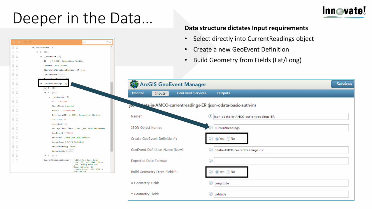
Ingestionclone an existing connector & tailor it’s properties to make a more specific connector
Ingestionclone an existing connector & tailor it’s properties to make a more specific connector

Ingestionextend GeoEvent by downloading additional transports & adapters
https://github.com/esri/solutions-geoevent-java
http://links.esri.com/geoevent-gallery

AnalyticsGeoEvent Services best practices
input1 output1buffer
• Which is better?
- have fewer but more complex GeoEvent Services
- or have more but simpler GeoEvent Services
geofences
filter(spatial)
input1 output2
geofences
filter(spatial)
geofences
geotagger
input2 output3
geofences
filter(spatial)
motioncalculator
geometry inside Zones/.*
geometry inside Zones/.* geometry inside Zones/.*
geometry inside Zones/.*

AnalyticsGeoEvent Services best practices
• Which is better?
- have fewer but more complex GeoEvent Services
- or have more but simpler GeoEvent Services
input1 output1buffer
geofences
filter(spatial)
input2 output2
geofences
geotagger
output3motion
calculator
geometry inside Zones/.*
geometry inside Zones/.*

dissemination & visualization3

you can create
your own
connectors
Disseminationuse an existing output connector
GeoEvent Server
Inp
uts
Ou
tpu
ts
GeoEvent Services
Ou
t o
f th
e B
ox
Add or Update a Feature
Publish Text to a UDP Socket
Send a Text Message
Send an Email
Push Text to an external TCP Socket
Push GeoJSON or JSON to an external WebSocket
Push GeoJSON or JSON to an external Website
Send an Instant Message
Send Features to a Stream Service
Write to a CSV, GeoJSON, or JSON File .csv
WS
im
HTTP
ActiveMQ
Esri
Gallery
Cursor-on-Target
Hadoop
Kafka
MongoDB
MQTT
RabbitMQ
Add a Feature to a spatiotemporal big data store
Update a feature in a spatiotemporal big data store

you can create
your own
connectors
Disseminationconfigure a new output connector by pairing an adapter & transport together
GeoEvent Server
Inp
uts
Ou
tpu
ts
GeoEvent Services
Message Formatter SMTP
Connectors TransportAdapter
Feature-JSON Kafka
Send an Email
Publish Feature-JSON to Kafka
Big Data Store
Transports
Feature Service
File
HTTP
HTTP+BasicAuth
HTTP+OAuth
SMTP
Stream Service
TCP
UDP
WebSocket
XMPP
Cache
Adapters
Feature-JSON
GeoJSON
JSON
Message Formatter
RSS
Text
WebSocket
ActiveMQ
Hadoop
IRC
Kafka
MongoDB
MQTT
Esri
Gallery
RabbitMQ
TCP-Squirt
Cursor-on-Target
Esri
Gallery
SMS

you can create
your own
connectors
GeoEvent Server
Inp
uts
Ou
tpu
ts
GeoEvent Services
Ou
t o
f th
e B
ox
Add or Update a Feature
Publish Text to a UDP Socket
Send a Text Message
Send an Email
Push Text to an external TCP Socket
Push GeoJSON or JSON to an external WebSocket
Push GeoJSON or JSON to an external Website
Send an Instant Message
Send Features to a Stream Service
Write to a CSV, GeoJSON, or JSON File .csv
WS
im
HTTP
ActiveMQ
Esri
Gallery
Cursor-on-Target
Hadoop
Kafka
MongoDB
MQTT
RabbitMQ
Add a Feature to a spatiotemporal big data store
Update a Feature in a spatiotemporal big data store
Visualizationvisualizing real-time observation results using Esri clients

Visualizationchoosing a service type: stream service, feature service, map service
Stream Layer
Map Layer
Feature Layer
• Stream layers in apps subscribe to stream services to immediately visualize observations
- does not require storage, low latency, no playback
• Map & Features layers in apps periodically poll to visualize most current observations
- backed by an enterprise geodatabase (EGDB) or a spatiotemporal big data store (BDS)
- history can be retrieved & queried for playback
desktop
device
web
ArcGIS
Enterprise
Stream Service
Send Features to a Stream Service subscribe (push)
polling (pull)
Map Service
Feature Service
GeoAnalytics
Server
Add a Feature to a BDS
Update a Feature in a BDS
spatiotemporal
big data store
Add or Update a Feature
EGDBGeoEvent
Server

Visualizationworkflow for creating a real-time service using stream service, feature service, map service
• Configure an input to receive real-time data & define a geoevent definition accordingly
• Create an output and publish a Stream / Feature / Map Service using the geoevent definition
• Author and publish a geoevent service
• Visualize your Stream / Feature / Map Service
ArcGIS Enterprise
spatiotemporal
big data storeGeoEvent
Server
input
geoevent
definition
geoevent service
Stream Service
Map Service
Feature Service
output

storage4
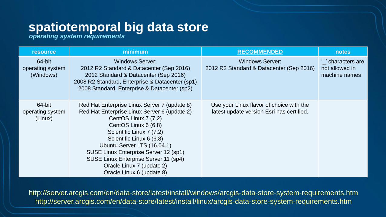
resource minimum RECOMMENDED notes
64-bit
operating system
(Windows)
Windows Server:
2012 R2 Standard & Datacenter (Sep 2016)
2012 Standard & Datacenter (Sep 2016)
2008 R2 Standard, Enterprise & Datacenter (sp1)
2008 Standard, Enterprise & Datacenter (sp2)
Windows Server:
2012 R2 Standard & Datacenter (Sep 2016)
‘_’ characters are
not allowed in
machine names
64-bit
operating system
(Linux)
Red Hat Enterprise Linux Server 7 (update 8)
Red Hat Enterprise Linux Server 6 (update 2)
CentOS Linux 7 (7.2)
CentOS Linux 6 (6.8)
Scientific Linux 7 (7.2)
Scientific Linux 6 (6.8)
Ubuntu Server LTS (16.04.1)
SUSE Linux Enterprise Server 12 (sp1)
SUSE Linux Enterprise Server 11 (sp4)
Oracle Linux 7 (update 2)
Oracle Linux 6 (update 8)
Use your Linux flavor of choice with the
latest update version Esri has certified.
http://server.arcgis.com/en/data-store/latest/install/windows/arcgis-data-store-system-requirements.htm
http://server.arcgis.com/en/data-store/latest/install/linux/arcgis-data-store-system-requirements.htm
spatiotemporal big data storeoperating system requirements

resource requirements: processors
http://server.arcgis.com/en/data-store/latest/install/windows/arcgis-data-store-system-requirements.htm
http://server.arcgis.com/en/data-store/latest/install/linux/arcgis-data-store-system-requirements.htm
resource minimum RECOMMENDED notes
processors 8 cores 16 cores
More processors results in
faster writes (indexing time),
higher write throughput &
faster query response time.
spatiotemporal big data store

resource requirements: processors, memory
http://server.arcgis.com/en/data-store/latest/install/windows/arcgis-data-store-system-requirements.htm
http://server.arcgis.com/en/data-store/latest/install/linux/arcgis-data-store-system-requirements.htm
resource minimum RECOMMENDED notes
processors 8 cores 16 cores
More processors results in
faster writes (indexing time),
higher write throughput &
faster query response time.
storage 400 GB 1 TB or moreStorage need is dictated by data velocity & size.
SSD results in much faster writes & queries.
spatiotemporal big data store
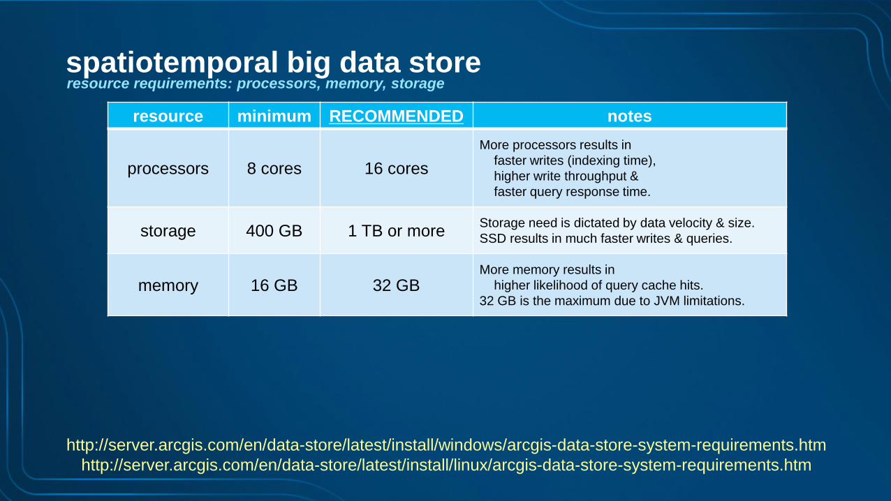
resource requirements: processors, memory, storage
http://server.arcgis.com/en/data-store/latest/install/windows/arcgis-data-store-system-requirements.htm
http://server.arcgis.com/en/data-store/latest/install/linux/arcgis-data-store-system-requirements.htm
resource minimum RECOMMENDED notes
processors 8 cores 16 cores
More processors results in
faster writes (indexing time),
higher write throughput &
faster query response time.
storage 400 GB 1 TB or moreStorage need is dictated by data velocity & size.
SSD results in much faster writes & queries.
memory 16 GB 32 GBMore memory results in
higher likelihood of query cache hits.
32 GB is the maximum due to JVM limitations.
spatiotemporal big data store

resource requirements: processors, memory, storage & instances
resource minimum RECOMMENDED notes
processors 8 cores 16 cores
More processors results in
faster writes (indexing time),
higher write throughput &
faster query response time.
storage 400 GB 1 TB or moreStorage need is dictated by data velocity & size.
SSD results in much faster writes & queries.
memory 16 GB 32 GBMore memory results in
higher likelihood of query cache hits.
32 GB is the maximum due to JVM limitations
# of
ISOLATED
instances
1 3 or more
With one instance there is risk of data loss.
With three instances replicas are written
increasing data reliability.
The # of instances will vary based on the velocity of
incoming data as well as the data retention policy
configured on each data source.
http://server.arcgis.com/en/data-store/latest/install/windows/arcgis-data-store-system-requirements.htm
http://server.arcgis.com/en/data-store/latest/install/linux/arcgis-data-store-system-requirements.htm
spatiotemporal big data store

spatiotemporal
big data store
GeoEvent
Server
shards & replication factor
GeoAnalytics
Server
node 1
node 2
node 3node 4
node 5
T1
T3
T2
T2
r = 1
T1
T3
spatiotemporal big data store
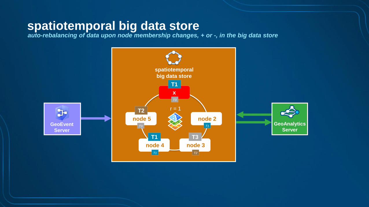
spatiotemporal
big data store
auto-rebalancing of data upon node membership changes, + or -, in the big data store
GeoEvent
Server
GeoAnalytics
Server
node 2
node 3node 4
node 5
T1
T3
T2
T2
r = 1
x
T1
T3
T1
T1T3
spatiotemporal big data store

purge based on
data retention
spatiotemporal
big data store
GeoEvent
Server
data retention policies, configured per data source
GeoAnalytics
Server
node 1
node 2
node 3node 4
node 5
r = 1
spatiotemporal big data store
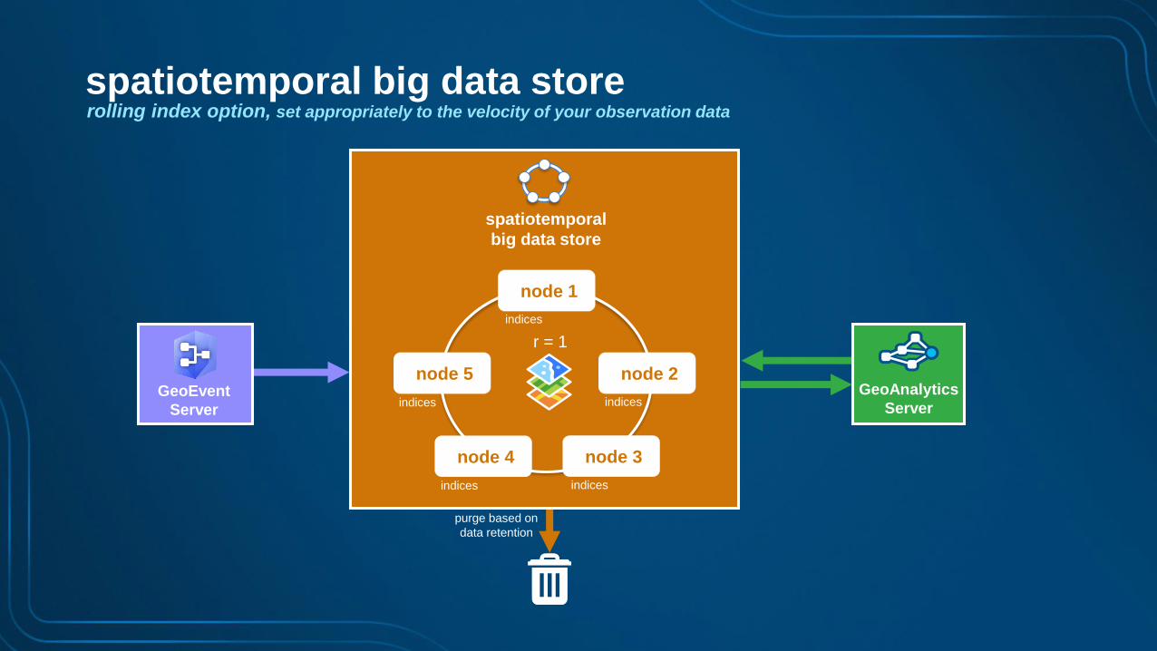
purge based on
data retention
spatiotemporal
big data store
GeoEvent
Server
rolling index option, set appropriately to the velocity of your observation data
GeoAnalytics
Server
node 1
node 2
node 3node 4
node 5
r = 1
indices indices
indices indices
indices
spatiotemporal big data store

purge based on
data retention
spatiotemporal
big data store
GeoEvent
Server
automatic data backups using periodic snapshots, including ability to restore from a snapshot
GeoAnalytics
Server
node 1
node 2
node 3node 4
node 5
r = 1
snapshot-2016-05-17-11-0-0.snapshot
snapshot-2016-05-17-12-0-0.snapshot
…
spatiotemporal big data store

choosing an Object Id optionspatiotemporal big data store
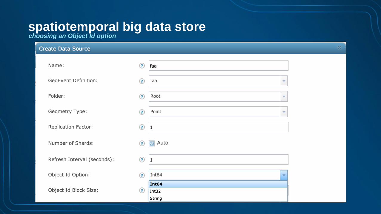
choosing an Object Id optionspatiotemporal big data store
choosing an Object Id option
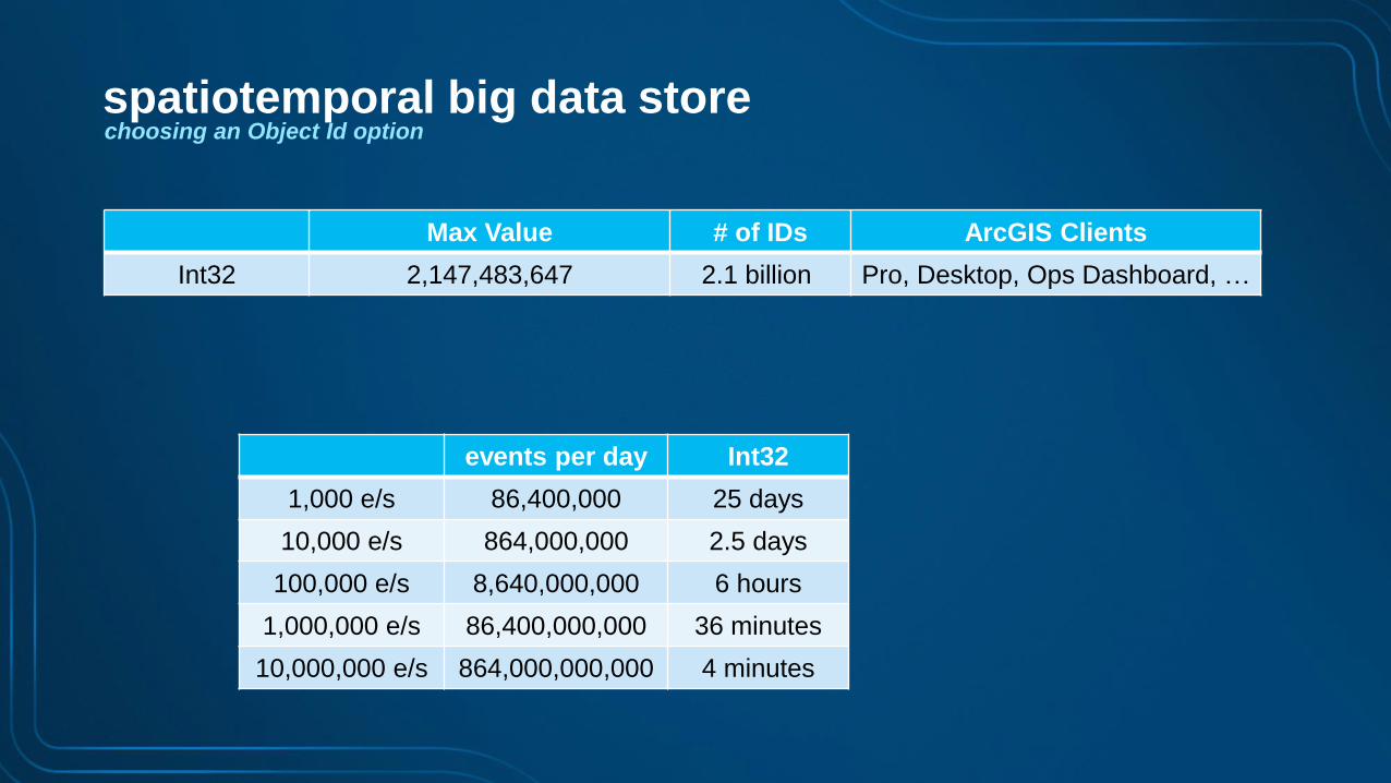
Max Value # of IDs ArcGIS Clients
Int32 2,147,483,647 2.1 billion Pro, Desktop, Ops Dashboard, …
events per day Int32
1,000 e/s 86,400,000 25 days
10,000 e/s 864,000,000 2.5 days
100,000 e/s 8,640,000,000 6 hours
1,000,000 e/s 86,400,000,000 36 minutes
10,000,000 e/s 864,000,000,000 4 minutes
spatiotemporal big data store

choosing an Object Id option
Max Value # of IDs ArcGIS Clients
Int32 2,147,483,647 2.1 billion Pro, Desktop, Ops Dashboard, …
Int64 (signed) 9,223,372,036,854,775,807 9.2 quintillion JavaScript, custom apps
events per day Int32
1,000 e/s 86,400,000 25 days
10,000 e/s 864,000,000 2.5 days
100,000 e/s 8,640,000,000 6 hours
1,000,000 e/s 86,400,000,000 36 minutes
10,000,000 e/s 864,000,000,000 4 minutes
spatiotemporal big data store
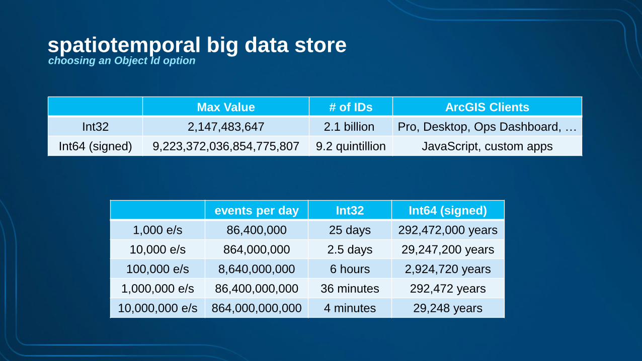
choosing an Object Id option
Max Value # of IDs ArcGIS Clients
Int32 2,147,483,647 2.1 billion Pro, Desktop, Ops Dashboard, …
Int64 (signed) 9,223,372,036,854,775,807 9.2 quintillion JavaScript, custom apps
events per day Int32 Int64 (signed)
1,000 e/s 86,400,000 25 days 292,472,000 years
10,000 e/s 864,000,000 2.5 days 29,247,200 years
100,000 e/s 8,640,000,000 6 hours 2,924,720 years
1,000,000 e/s 86,400,000,000 36 minutes 292,472 years
10,000,000 e/s 864,000,000,000 4 minutes 29,248 years
spatiotemporal big data store

choosing an Object Id option
Max Value # of IDs ArcGIS Clients
Int32 2,147,483,647 2.1 billion Pro, Desktop, Ops Dashboard, …
Int64 (signed) 9,223,372,036,854,775,807 9.2 quintillion JavaScript, custom apps
UniqueStringID n/a unlimited JavaScript, custom apps
events per day Int32 Int64 (signed)
1,000 e/s 86,400,000 25 days 292,472,000 years
10,000 e/s 864,000,000 2.5 days 29,247,200 years
100,000 e/s 8,640,000,000 6 hours 2,924,720 years
1,000,000 e/s 86,400,000,000 36 minutes 292,472 years
10,000,000 e/s 864,000,000,000 4 minutes 29,248 years
spatiotemporal big data store

resilience & scalability5

best practices
000
GeoEvent resilience & scalability
• GeoEvent clustering was introduced at 10.3
• However, observed to be brittle and subject to failure:
- Must have at least 3 nodes in a cluster
- when a node goes down, it must be brought back up ASAP.
- a 2-node cluster can cause a split-brain condition in cluster.
- Must be physical hardware
- many customers only have virtualized environments.
- Network must be stable
- network instabilities can result in intermittent membership.
• Given this, clustering GeoEvent
- should be avoided and is discouraged
• Instead, if resiliency or addt’l scalability is required:
- isolated deployments should be employed
- this is true at 10.3, 10.4 and 10.5

isolated deployment
• Each GeoEvent instance exists in it’s own site and shares a common configuration manually.
• A message broker must be stood up in front to provide a common event source.
• GeoEvent instances share a common message broker and run active/active competing to
consume events.
GeoEvent resilience & scalability
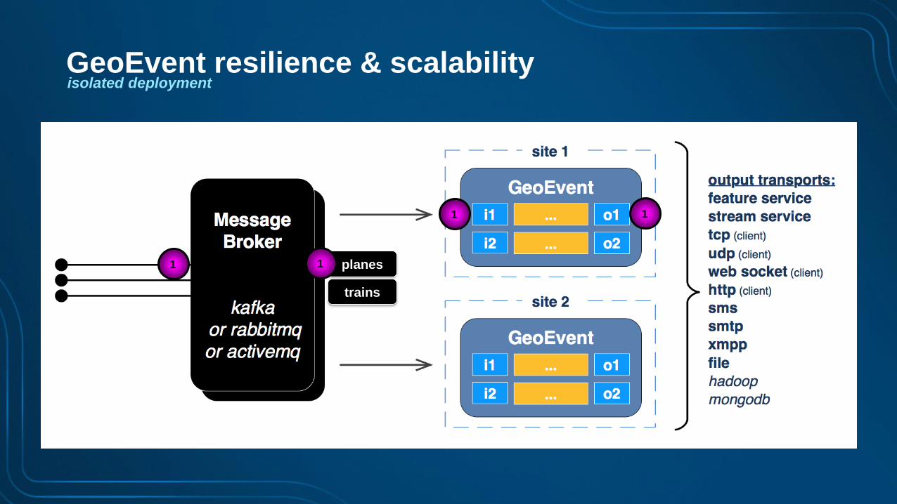
isolated deployment
planes
trains
1 1
1 1
GeoEvent resilience & scalability

isolated deployment
planes
trains
2
2 2
2
GeoEvent resilience & scalability

isolated deployment
planes
trains
1 1
1 1
GeoEvent resilience & scalability

isolated deployment
• Known constraints:
- does not support failover of state: enter, exit, track gap detection, idle detector
- project team/IT staff needed to setup/configure message broker and get all sensor events into it
- input to GeoEvent is the message broker only, lose flexibility of all the input connectors available.
GeoEvent resilience & scalability
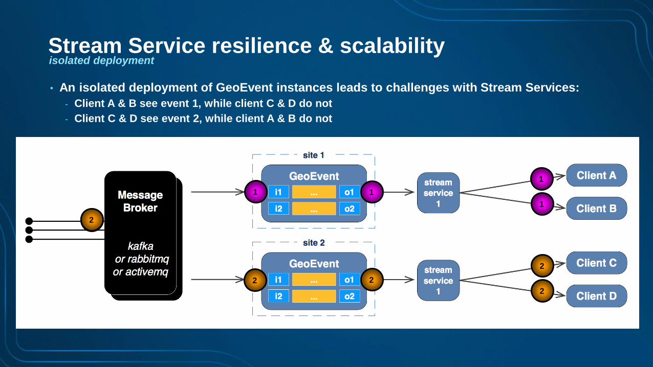
isolated deployment
• An isolated deployment of GeoEvent instances leads to challenges with Stream Services:
- Client A & B see event 1, while client C & D do not
- Client C & D see event 2, while client A & B do not
1
1 1
1
1
2
2
2
2
2
Stream Service resilience & scalability

isolated deployment
• Using Kafka the GeoEvent instances can be configured to use separate consumer groups:
- With this configuration, all clients see all events
- note: can also be accomplished with RabbitMQ fan-outs or ActiveMQ topics
1
1 1
1
1
1 1
1
1
Stream Service resilience & scalability

isolated deployment
• Using Kafka the GeoEvent instances can be configured to use separate consumer groups:
- With this configuration, all clients see all events
- note: can also be accomplished with RabbitMQ fan-outs or ActiveMQ topics
2
2
2
2
2
2 2
2
2
1
1
1
1
Stream Service resilience & scalability

isolated deployment
• A reverse proxy can be configured in between the clients and the stream services so that clients
don’t have direct knowledge of the servers they are connecting to.
- NGiNX is one such reverse proxy.
1
1 1
1 1
1
1
1
1
Stream Service resilience & scalability

isolated deployment
• Using Kafka the GeoEvent instances can be configured to use separate consumer groups:
- With this configuration, all clients see all events
- note: can also be accomplished with RabbitMQ fan-outs or ActiveMQ topics
2
2
2
2 2
2
2
1
1
1
1
Stream Service resilience & scalability

deploying at a massive scale6

ArcGIS Enterprisewith real-time & big data capabilities
ArcGIS
Enterprise
Big DataIoT
GeoEvent
Server
spatiotemporal
big data store
GeoAnalytics
Server

ArcGIS
Enterprise
with real-time & big data capabilities
• A new class of customer is demanding MASSIVE real-time & big data analytic capabilities.
ArcGIS Enterprise
big data analytics & storageingestion & real-time analytics
Big DataIoT
Real-Time & Big Data GIS
Tue, 5:15pm-6:15pm, Room 151Aat a Massive Scale

SummaryGeoEvent Server: best practices
• When applying Real-Time GIS there are many best practices for
- ingestion & analytics
- dissemination & visualization
- storage
- resilience & scalability
• To learn more:
- See the tutorial:
‘ArcGIS GeoEvent Server: Resiliency’
coming soon

Real-Time & Big Data GIS
• Applying Real-Time Analytics Mon, 1:45pm-2:45pm, Room 147B
Tue, 11:00am-12:00pm, Room 151B
• Leveraging the Spatiotemporal Big Data Store Mon, 3:00pm-4:00pm, Room 147B
Tue, 1:30pm-2:30pm, Room 151B
• ArcGIS GeoAnalytics: Intro to Big Data Feature Analytics Mon, 4:15pm-5:15pm, Room 147B
Tue, 2:45pm-3:45pm, Room 147A
• Leveraging Stream Services Tue, 2:45pm-3:45pm, Room 151A
• ArcGIS GeoEvent Server: Best Practices Tue, 4:00pm-5:00pm, Room 151A
• Real-Time & Big Data GIS at a Massive Scale Tue, 5:15pm-6:15pm, Room 151A
other sessions

Please Take Our Survey on the Esri Events App!
Select the session
you attended
Scroll down to find
the survey
Complete Answers
and Select “Submit”
Download the Esri Events
app and find your event

Print Your Certificate of Attendance
Print stations located in the 140 Concourse
Monday
12:30 PM – 6:30 PM
GIS Solutions Expo,
Hall B
5:15 PM – 6:30 PM
Expo Social,
Hall B
Tuesday
10:45 AM – 5:15 PM
GIS Solutions Expo,
Hall B
6:30 PM – 9:30 PM
Networking Reception,
Smithsonian National Air
and Space Museum

Questions / Feedback?
http://links.esri.com/geoevent
http://links.esri.com/geoevent-forum
To learn more:
Frank RobertsDirector of IT Services, Innovate
Adam MollenkopfReal-Time & Big Data GIS Capability Lead, Esri
@amollenkopf
Suzanne FossReal-Time & Big Data Product Engineer, Esri
@sfoss_esri