Embed Size (px)
DESCRIPTION
Arbogast Sample Chapter 1
Citation preview


C H A P T E R P R E V I E W
C H A P T E R O N EINTRODUCTION TO PHYSICAL GEOGRAPHY
The Scope of Geography
Defining Physical Geography
Organization of This BookOn the Web: GeoDiscoveries Stream Meandering
The Big Picture
This view of Wilson Peak in Colorado reflects many geographical processes discussed in this text, including the character of the atmosphere, how water is stored and seen in the hydrosphere, the role of climate and its impact on vegetation, and the way that landscapes evolve over time.
L E A R n I n g O b j E C T I V E s
1. Comprehend the character and scope of geogra-phy as a scientific discipline.
2. Discuss the concept of spatial analysis and how it relates to geography.
3. Define the subdisciplines of physical geography.
4. Explain the concept of a natural system.
5. Define the four Earth spheres.
6. Describe how the scientific method is used in physical geography.
7. Discuss why physical geography is relevant to many human/environment issues.
I want to welcome you to this introductory textbook about physical geography. Physical geography is an
exciting scientific discipline that is central to our understanding of Earth and how it functions. Every region
of the planet is part of a delicately balanced natural system that has distinctive physical characteristics,
including the type of climate, weather, vegetation, soils, and landforms. These characteristics are the result
of processes that, in some cases, have been operating for millions of years. These processes often cause
incremental changes that are barely noticeable in a human lifetime. In other cases, noticeable changes can
occur over the course of a single day. As you read through the text, your first goal should be to examine
these physical processes and resulting geographical patterns on Earth. A second goal is to examine some
ways that Earth systems and associated processes affect human lives and, in turn, how people impact them.
This opening chapter outlines the topics discussed in this book and places them in the context of the overall
discipline of geography. Then we discuss the various components and features of the book and how they will
assist with your learning.
2 3
arbo_c01_002-013v2.indd 2-3 9/14/10 4:26 PM

4 Chapter 1 • Introduction to Physical Geography Defining Physical Geography • 5
on Earth. As the name implies, movement is related to the way that geographical variables flow from one locality to another. Human/environment interaction acknowledges the complex bond between people and nature. The con-cept of place is an important theme in geography because it reflects the characteristics that make a certain location distinct. Finally, a region is an area that shares one or more common characteristics.
In the context of the five themes, all geographers share a common methodology that makes them part of the overall discipline. Geographers use a method known as spatial analysis, which attempts to explain pat-terns or distributions of specific variables over physical space. Most geographers are fundamentally interested in knowing two things: where and why. In other words, geographers examine why a specific environmental or cultural variable in a specific place or region has one particular set of characteristics, whereas the same vari-able someplace else has different characteristics.
For example, consider for a moment an example in-volving cultural diversity. The Middle East is a region of Earth that is culturally diverse, with many different reli-gious sects, dialects, and tribal identities. Although this diversity has produced a rich heritage, it has also resulted in a great deal of conflict between and among various cultural groups. A cultural geographer can examine the spatial distribution of the many groups in the area (in
other words, where are they?), as well as study why people in one place differ in, say, their political or religious views, from people someplace else. The geographer might look for similarities (such as language) among groups across physical space, which might explain why certain people align themselves politically with others. In the course of this study, the geographer would have integrated several variables into one picture, including language, religion, history, and climate. Such a study might contribute to an understanding of why people differ across this region and why sources of conflict remain.
Defining Physical Geography
Now that the fundamental nature of geography as a broad field has been defined, let us focus on a more comprehensive definition of physical geography. You probably already have some kind of an interest in physical geography, whether you know it or not. For example, have you ever wondered why violent storms occur? You may know that tornadoes frequently occur in the central United States, especially in the spring-time (Figure 1.2a). Do you know why? Maybe you wonder why large mountains are found in Washington but not in Texas (Figure 1.2b). Perhaps you have heard about the Sahara Desert and wonder why it is so dry there and why much of it is covered with sand dunes (Figure 1.2c). Like many people, you might enjoy the seashore and wonder why nice beaches form in some places (Figure 1.2d) but not in others. If you have asked yourself questions like these, then you are
The Scope of Geography
When most people are asked to define the nature of ge-ography, the usual response is it focuses on the locations of countries, capital cities, rivers, and oceans. Although the location of places is certainly a part of geography, the field encompasses much more. In fact, you may be surprised to learn that whatever you like to do and wherever you live, geography is very much a part of your everyday life.
Geography is an ancient discipline that examines the spatial attributes of the Earth’s surface and how they differ from one place to another. Derived from the Greek words for “Earth description,” the concept of geography has likely been a central part of the hu-man experience for tens of thousands of years. It is easy to imagine, for example, that prehistoric hunters and gatherers were intimately aware of their surroundings, including the location and character of forests, streams, lakes, berry patches, animal herds, and competing groups of people. In short, an understanding of local geography would have been absolutely essential to sustain life. It would also have been necessary to be able to describe those patterns for future generations so they, in turn, could thrive.
So, for thousands of years at least, geography was a descriptive discipline that focused on the generalized location and character of places and things. Slowly, how-ever, geography became an academic discipline with numerous specialized subfields. Scientists became ex-perts in areas such as geology, meteorology, ecology, and human cultural differences. Interest in geography grew especially between the 15th and 19th centuries when ex-plorers like Christopher Columbus, Ferdinand Magel-
lan, James Cook, Charles Darwin, and Lewis and Clark began to investigate parts of the world that were previ-ously unknown to people of European descent (includ-ing Americans). These explorers, as well as many others, brought detailed descriptions of exotic places and ani-mals to a keenly interested public. The new knowledge and perspectives gained from this time were a major driving force for the development of the modern world.
The trend toward specialization in geography has continued to the present time. Most geographers con-sider themselves first of all to be either a physical or human specialist. Within these two broad fields are a range of geographical subdisciplines, as shown in Fig-ure 1.1a. Although each of these subfields has a unique focus, such as soils or agricultural land use, geographers draw from many of these subfields when they analyze any particular geographical pattern. For example, to fully understand human settlement patterns in Africa, it is important to consider the interaction of subfields such as climatology, soils, and vegetation, to name a few. In turn, to understand the nature of soils in any given place, you must consider the effects of climatology, vegetation, geomorphology, and perhaps even regional cultural practices (Figure 1.1b).
Although the focus of this book is physical geogra-phy, it is important to know that all subfields of geography are based on the same five themes of location, movement, place, human/environment interaction, and region. Loca-tion refers to the exact position where something is found
Climatology Remote sensing
GeographyPhysical Human
Geographic informationsystems
Hazard assessment
Biogeography Economic geography
Cultural geography
Historical geography
Medical geography
Political geography
Marine geography
Geomorphology
Soils
Environmentalgeography
Agricultural land use
Regional development
Figure 1.1 Subdisciplines of geography. (a) The field of geography can be broadly subdivided into physical and human geog-raphy. Many subfields occur within these two broad categories, with many that overlap. (b) Physical geography itself over-laps with several other areas of science. Many of these areas require a good understanding of chemistry and physics as well.
(a)
Ecology
Biogeography
Climatology Hydrology
Geology
PhysicalGeography
Meteorology
Soils
Geomorphology
(b)
(a) (c)
(b)
Figure 1.2 Some elements of physical ge-ography. (a) A tornado in the central Unit-ed States (see Chapter 8). (b) The Olym-pic Mountains overlooking Puget Sound in Washington (see Chapter 13). (c) Sand dunes in the Sahara Desert (see Chapters 9 and 18). (d) Coastline at Big Sur in north-ern California (see Chapter 19).
(d)
Spacial analysis A method of analyzing data that spe-cifically includes information about the location of places and their defining characteristics.
arbo_c01_002-013v2.indd 4-5 9/14/10 4:26 PM

6 Chapter 1 • Introduction to Physical Geography Defining Physical Geography • 7
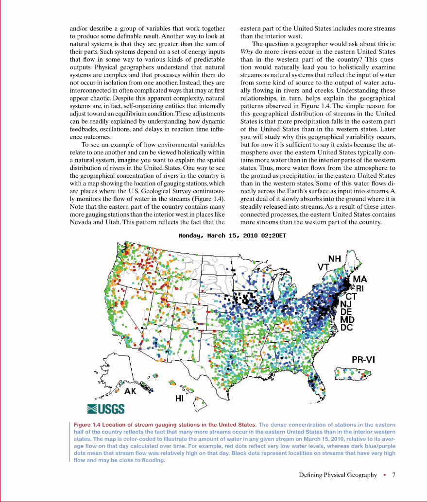
eastern part of the United States includes more streams than the interior west.
The question a geographer would ask about this is: Why do more rivers occur in the eastern United States than in the western part of the country? This ques-tion would naturally lead you to holistically examine streams as natural systems that reflect the input of water from some kind of source to the output of water actu-ally flowing in rivers and creeks. Understanding these relationships, in turn, helps explain the geographical patterns observed in Figure 1.4. The simple reason for this geographical distribution of streams in the United States is that more precipitation falls in the eastern part of the United States than in the western states. Later you will study why this geographical variability occurs, but for now it is sufficient to say it exists because the at-mosphere over the eastern United States typically con-tains more water than in the interior parts of the western states. Thus, more water flows from the atmosphere to the ground as precipitation in the eastern United States than in the western states. Some of this water flows di-rectly across the Earth’s surface as input into streams. A great deal of it slowly absorbs into the ground where it is steadily released into streams. As a result of these inter-connected processes, the eastern United States contains more streams than the western part of the country.
and/or describe a group of variables that work together to produce some definable result. Another way to look at natural systems is that they are greater than the sum of their parts. Such systems depend on a set of energy inputs that flow in some way to various kinds of predictable outputs. Physical geographers understand that natural systems are complex and that processes within them do not occur in isolation from one another. Instead, they are interconnected in often complicated ways that may at first appear chaotic. Despite this apparent complexity, natural systems are, in fact, self-organizing entities that internally adjust toward an equilibrium condition. These adjustments can be readily explained by understanding how dynamic feedbacks, oscillations, and delays in reaction time influ-ence outcomes.
To see an example of how environmental variables relate to one another and can be viewed holistically within a natural system, imagine you want to explain the spatial distribution of rivers in the United States. One way to see the geographical concentration of rivers in the country is with a map showing the location of gauging stations, which are places where the U.S. Geological Survey continuous-ly monitors the flow of water in the streams (Figure 1.4). Note that the eastern part of the country contains many more gauging stations than the interior west in places like Nevada and Utah. This pattern reflects the fact that the
solar radiation. Once this energy reaches Earth, it then flows from one place to another on the planet in vari-ous forms. Some examples of natural processes directly related to the flow of solar radiation (Figure 1.3) are the circulation of the atmosphere (Chapter 7), the distribu-tion of vegetation (Chapter 10), the formation of soils (Chapter 11), and the movement of water in the air, in streams, and collecting in lakes (Chapters 5 and 16).
As you will see throughout the book, many processes behave in an interconnected way within natural systems where one environmental variable has a direct impact on another. Given these relationships, physical geographers often invoke systems theory in their studies because it is a holistic framework through which someone can analyze
(c)(a)
(b) (d)
Figure 1.3 Examples of energy flows on Earth. (a) Earth receives its energy from the Sun in the form of solar radiation (see Chapters 3 and 4). (b) The atmosphere circulates energy around Earth, as can be seen in this stream of clouds (see Chapter 7). (c) Some energy is transferred when water flows from the atmosphere to Earth as rain (see Chapter 5). (d) Some of the energy on the surface of Earth is transferred by flowing water (see Chapter 16).
Physical geography Spatial analysis of the physical components and natural processes that combine to form the environment.
Process A naturally occurring series of events or reactions that can be measured and that result in predictable outcomes.
Figure 1.4 Location of stream gauging stations in the United States. The dense concentration of stations in the eastern half of the country reflects the fact that many more streams occur in the eastern United States than in the interior western states. The map is color-coded to illustrate the amount of water in any given stream on March 15, 2010, relative to its aver-age flow on that day calculated over time. For example, red dots reflect very low water levels, whereas dark blue/purple dots mean that stream flow was relatively high on that day. Black dots represent localities on streams that have very high flow and may be close to flooding.
probably interested in physical geography at some level. The fact is most people are; they just do not realize it.
Simply stated, physical geography involves the spatial analysis of the various physical components and natural processes of the Earth. Some examples of Earth’s physical components are air, water, rocks, veg-etation, and soil. The term process broadly refers to a series of actions that can be measured and which pro-duce a predictable end result. In physical geography, these processes are fundamentally products of the en-ergy that flows from the Sun to Earth in the form of
Systems theory The examination of interactions in-volving energy inputs and outputs that result in predict-able outcomes.
arbo_c01_002-013v2.indd 6-7 9/14/10 4:26 PM
6 Chapter 1 • Introduction to Physical Geography Defining Physical Geography • 7
eastern part of the United States includes more streams than the interior west.
The question a geographer would ask about this is: Why do more rivers occur in the eastern United States than in the western part of the country? This ques-tion would naturally lead you to holistically examine streams as natural systems that reflect the input of water from some kind of source to the output of water actu-ally flowing in rivers and creeks. Understanding these relationships, in turn, helps explain the geographical patterns observed in Figure 1.4. The simple reason for this geographical distribution of streams in the United States is that more precipitation falls in the eastern part of the United States than in the western states. Later you will study why this geographical variability occurs, but for now it is sufficient to say it exists because the at-mosphere over the eastern United States typically con-tains more water than in the interior parts of the western states. Thus, more water flows from the atmosphere to the ground as precipitation in the eastern United States than in the western states. Some of this water flows di-rectly across the Earth’s surface as input into streams. A great deal of it slowly absorbs into the ground where it is steadily released into streams. As a result of these inter-connected processes, the eastern United States contains more streams than the western part of the country.
and/or describe a group of variables that work together to produce some definable result. Another way to look at natural systems is that they are greater than the sum of their parts. Such systems depend on a set of energy inputs that flow in some way to various kinds of predictable outputs. Physical geographers understand that natural systems are complex and that processes within them do not occur in isolation from one another. Instead, they are interconnected in often complicated ways that may at first appear chaotic. Despite this apparent complexity, natural systems are, in fact, self-organizing entities that internally adjust toward an equilibrium condition. These adjustments can be readily explained by understanding how dynamic feedbacks, oscillations, and delays in reaction time influ-ence outcomes.
To see an example of how environmental variables relate to one another and can be viewed holistically within a natural system, imagine you want to explain the spatial distribution of rivers in the United States. One way to see the geographical concentration of rivers in the country is with a map showing the location of gauging stations, which are places where the U.S. Geological Survey continuous-ly monitors the flow of water in the streams (Figure 1.4). Note that the eastern part of the country contains many more gauging stations than the interior west in places like Nevada and Utah. This pattern reflects the fact that the
solar radiation. Once this energy reaches Earth, it then flows from one place to another on the planet in vari-ous forms. Some examples of natural processes directly related to the flow of solar radiation (Figure 1.3) are the circulation of the atmosphere (Chapter 7), the distribu-tion of vegetation (Chapter 10), the formation of soils (Chapter 11), and the movement of water in the air, in streams, and collecting in lakes (Chapters 5 and 16).
As you will see throughout the book, many processes behave in an interconnected way within natural systems where one environmental variable has a direct impact on another. Given these relationships, physical geographers often invoke systems theory in their studies because it is a holistic framework through which someone can analyze
(c)(a)
(b) (d)
Figure 1.3 Examples of energy flows on Earth. (a) Earth receives its energy from the Sun in the form of solar radiation (see Chapters 3 and 4). (b) The atmosphere circulates energy around Earth, as can be seen in this stream of clouds (see Chapter 7). (c) Some energy is transferred when water flows from the atmosphere to Earth as rain (see Chapter 5). (d) Some of the energy on the surface of Earth is transferred by flowing water (see Chapter 16).
Physical geography Spatial analysis of the physical components and natural processes that combine to form the environment.
Process A naturally occurring series of events or reactions that can be measured and that result in predictable outcomes.
Figure 1.4 Location of stream gauging stations in the United States. The dense concentration of stations in the eastern half of the country reflects the fact that many more streams occur in the eastern United States than in the interior western states. The map is color-coded to illustrate the amount of water in any given stream on March 15, 2010, relative to its aver-age flow on that day calculated over time. For example, red dots reflect very low water levels, whereas dark blue/purple dots mean that stream flow was relatively high on that day. Black dots represent localities on streams that have very high flow and may be close to flooding.
probably interested in physical geography at some level. The fact is most people are; they just do not realize it.
Simply stated, physical geography involves the spatial analysis of the various physical components and natural processes of the Earth. Some examples of Earth’s physical components are air, water, rocks, veg-etation, and soil. The term process broadly refers to a series of actions that can be measured and which pro-duce a predictable end result. In physical geography, these processes are fundamentally products of the en-ergy that flows from the Sun to Earth in the form of
Systems theory The examination of interactions in-volving energy inputs and outputs that result in predict-able outcomes.
arbo_c01_002-013v2.indd 6-7 9/14/10 4:26 PM

8 Chapter 1 • Introduction to Physical Geography Organization of This Book • 9
mation that ranges in scale from global to local, which will allow you to better grasp your place both in the world and even your neighborhood. Chapter 2 will fo-cus on the various kinds of tools that geographers use in their work, such as maps, remote sensing, and geographi-cal information systems. Chapters 3 through 5 center on our relationship with the Sun (Chapter 3), the way we receive solar radiation (Chapter 4), and how those inter-actions relate to temperature (Chapter 5). The processes discussed in these chapters will prepare you for the top-ics that will be covered in the rest of the book. Chapters 6
ages, the Earth’s magnetic field, and even other planets (Figure 1.6). For these investigations to occur, it is essen-tial that scientists understand physical laws and have the ability to mathematically analyze and compare them.
Organization of This Book
The chapters in this book are organized to provide you with a good understanding of the fundamental concepts associated with physical geography. They contain infor-
3. Hydrosphere—The hydrosphere is the part of Earth where water, in all its forms (solid ice, liquid water, and gaseous water vapor), flows and is stored. This sphere is absolutely critical to life and is one with which humans regularly interact—for example, through irrigation and navigation.
4. Biosphere—The biosphere is the living portion of Earth and includes all the plants and animals (in-cluding humans) on the planet. Various components of this sphere regularly flow from one place to an-other, both on a seasonal basis and through human intervention. Humans interact with this sphere in a wide variety of ways, with agriculture being a very prominent example.
These four spheres overlap to form the natural envi-ronment that makes Earth a unique place within our solar system. Physical geography examines the spatial variation within these spheres, how natural systems work within them, the observable outcomes in each, and the manner in which components flow from one sphere to another.
Physical geography can be a descriptive discipline that simply characterizes the nature of the Earth’s spheres in specific regions. A simple example of such a descriptive focus would be to acknowledge that the west-ern part of the United States is mountainous, whereas the central part of the country consists mostly of rela-tively level plains. Physical geography is also a science because research is conducted within the framework of the scientific method, which is the systematic pursuit of knowledge through the recognition of a problem, the formulation of hypotheses, and the testing of hypoth-eses through the collection of data by measurement, observation, and experiment. The conclusions derived from the systematic application of the scientific method contribute to the formulation of scientific theories and laws that explain how Earth functions.
A simple example of using the scientific method in physical geography would be to test the hypothesis that water in streams within a certain region is acidic. This hypothesis would best be tested by collecting water sam-ples from a number of streams and conducting chemical analyses on them to determine their acid levels. If high acid levels were indeed obtained, then an effort would be made to explain why that pattern occurred. In addi-tion to understandings produced in these kinds of analy-ses, physical geographers also test hypotheses about all sorts of natural phenomena by collecting information from the atmosphere, rocks, soils, ice cores, satellite im-
The Earth’s Four SpheresAs you can imagine, a huge number of component/process combinations exist for geographical study in a holistic way. In physical geography, these various com-binations can be grouped into the four “spheres” on Earth (Figure 1.5):
1. Atmosphere—The atmosphere is the gaseous shell that surrounds Earth. This sphere is composed of many critical components essential to life, such as oxygen, carbon, water, and nitrogen, to name a few, that flow around Earth.
2. Lithosphere—The lithosphere is the solid part of Earth, including soil and minerals. A good example of a natural system in this sphere is the way in which water, minerals, and organic matter flow in the outer-most layer of the Earth to form soil. This sphere pro-vides the habitat and nutrients for many life forms.
Atmosphere Hydrosphere
Earth
Lithosphere Biosphere
Figure 1.5 The four Earth spheres. Each sphere en-compasses a major component of the Earth’s natural environment.
Hydrosphere The part of the Earth where water, in all its forms, flows and is stored.
Biosphere The portion of Earth and atmosphere that supports life.
Figure 1.6 Examples of collecting scientific data about Earth. (a) Many space shuttle missions are designed to obtain measurements about the atmosphere, oceans, and the distribution and character of plants, among many other things. (b) To learn about the behavior of streams in the past, scientists study the type of sediment deposited by the stream through time. This picture is from one of my class field trips in the Great Plains. (c) One way to learn about past climate changes on Earth is to obtain samples of ancient ice on the Greenland and Antarctic ice caps. (d) New methods of surveying enable scientists to obtain accurate measurements about elevation and location.
(a)
(c)
(b)
(d)
Atmosphere The gaseous shell that surrounds Earth.
Lithosphere A layer of solid, brittle rock that compris-es the outer 70 km (44 mi) of Earth.
arbo_c01_002-013v2.indd 8-9 9/14/10 4:26 PM

10 Chapter 1 • Introduction to Physical Geography Organization of This Book • 11
text’s accompanying website. One of the modules in that chapter shows how streams snake across the river valley in a process called meandering. Through this process, the geographical position of streams actually moves through time. The GeoDiscoveries module shows this process in animated form, which will enable you to comprehend it better. Have a look now to see what these modules are like.
Focus on Geographical LiteracyIn addition to improving your overall understanding of physical geography and how it relates to human/envi-ronmental issues, another goal of this book is to enhance your geographical literacy. It is common knowledge that the overall geographical literacy of average Americans is very poor. How many Americans can identify, for ex-ample, the countries of the Middle East, where so much of our national focus is presently centered? This illiter-acy not only extends to the world at large, but also ap-plies to the United States. In a poll a few years ago, for example, Americans chose more than 30 different states (of the 50 in the country) as being the state of New York.
Geographical literacy also involves knowing the location of distinct physical regions on Earth, such as the Sahara Desert or the Himalaya Mountains, and why they exist. In this context, you will see that discus-sions include maps of the places described. I also hope that your visual geographical literacy will improve by using this text. In other words, this book is designed to sharpen your eye so that when you see things on the landscape, which you may have previously ignored, you might better appreciate them and why they occur. Two features—What a Geographer Sees and Visual Concept Check—are specifically designed to help you improve this aspect of your geographical literacy. The What a Geographer Sees feature allows you to see the physical landscape through the eyes of a geographer. In other
that the hurricane had on a variety of issues, including the shape of the coastline, distribution of wetlands, and the regional economy, to name just a few. These stud-ies have profound implications for future environmen-tal decisions, politics, and economic development in the Gulf region. Several chapters contain sections specifi-cally devoted to such human–environment interactions, including a discussion of solar energy production in Chapter 4, wind energy in Chapter 5, and petroleum in Chapter 12, to name a few. The final chapter (Chapter 20) is entirely devoted to these kinds of issues and dem-onstrates how physical geography is highly relevant to human–environmental interactions.
GeoDiscoveries: An Interactive ToolThese holistic discussions in the text are accompanied by graphics and photographs, as well as a more dynamic tool—interactive digital modules called GeoDiscoveries. These modules consist of a variety of animations and simu-lations that allow you to visualize and manipulate many of the factors associated with geographical processes and see the results over time and space. The animations and simu-lations will enhance your learning as you participate more closely with geographical processes and will reinforce the interactive nature of the discipline by showing related vari-ables in motion. The media are integrated entirely within the chapter text as distinct sections that explain what you should expect to learn by interacting with them.
Here is a good example of how the digital modules will enhance your learning. As you may already know, riv-ers are bodies of water that flow from one place to anoth-er. This concept is described in great detail in Chapter 16. This discussion is accompanied by a variety of diagrams that illustrate how water flows, using flow lines and ar-rows embedded within them. It is also supplemented by several GeoDiscoveries modules that are accessed on the
way that this material is presented is through the tradi-tional use of text accompanied by photographs, diagrams, and tables. Each chapter contains detailed discussions that connect important concepts to events that you may have experienced. Each chapter also ends with a visual preview of the next chapter specifically designed to show how one chapter relates to the next.
Emphasis on Human Interactions with the Environment Many of the scientific analyses associated with physical geography are driven by the growing impact that human activities have within and among the Earth spheres. Giv-en the nature of human impact on the natural environ-ment, physical geography is at the forefront of research on many environmental issues that face the world today. These issues include (to name a very few):
• Global climate change—Human industrial activi-ties are increasing the levels of carbon dioxide in the atmosphere. Abundant evidence suggests that this relationship is contributing significantly to global climate change.
• Deforestation—The clearing of the tropical rain-forests is occurring at a very rapid rate, leading to soil erosion, loss of wildlife habitat, and species extinctions.
• Farmland loss—Due to increasing global popula-tion, farmland is being converted to zones of eco-nomic development and residential housing. This loss of farmland is resulting in more intensive farm-ing of agricultural soils still in use, which increases the risk of soil erosion and pollution due to the ex-tensive application of fertilizers and pesticides.
• Natural hazards—Hazards occur when extreme events result in danger to humans. Examples of nat-ural hazards include hurricanes, tornadoes, flooding, earthquakes, and volcanoes. Natural hazards are a particularly important area of geographical study because as the global population grows, increasing numbers of people are moving into areas that are susceptible to extreme natural events.
A recent natural disaster in the United States viv-idly illustrates the integrated nature of physical geog-raphy and the critical role that geographers play with respect to solving real-world problems. As you probably know, Hurricane Katrina devastated the Gulf Coast in the summer of 2005, causing billions of dollars of dam-age, much of it occurring when the city of New Orleans was extensively flooded. Before the storm reached land, geographers were at the forefront of the effort to monitor the storm’s path and predict where the most significant damage would occur. Once the storm passed, geographers began conducting research on the impact
through 9 revolve around the atmosphere, including the way that air circulates within it (Chapter 6), precipitation processes (Chapter 7), weather systems (Chapter 8), and global climate patterns (Chapter 9). The text then exam-ines the influence of the atmosphere and how it interacts with Earth’s other spheres by focusing on plant geogra-phy in Chapter 10 and soils in Chapter 11.
Chapters 12 through 19 of the book deal mainly with the lithosphere and hydrosphere. Chapter 12 describes the Earth’s internal structure, rock cycle, and geologic time. This discussion leads directly into Chapter 13, which focuses on the lithosphere and tectonic landforms. From there, we turn your attention in Chapter 14 to the way that rocks weather and how sediment moves through mass wasting processes. Chapters 15 and 16 discuss the way that water moves on Earth and how it is stored with-in it. Chapter 15 focuses specifically on groundwater pro-cesses and the formation of landforms such as caves. In Chapter 16 we look at how water flows across the surface in stream systems and the landforms that result. Chap-ters 17 through 19 are devoted to specific geomorphic processes and the resulting landforms, including glaciers (Chapter 17), eolian (wind) processes and arid landscapes (Chapter 18), and coastal regions (Chapter 19).
Exploring Cause-and-Effect Relationships HolisticallyAs you work through these chapters, you will constantly see the effects of interactions between the four Earth spheres. To understand how such interactions work, take a quick look at a recent drought in the southeastern Unit-ed States, which hit Georgia particularly hard between 2005 and early 2009. With this problem in mind consider the following question, one that encompasses elements of the atmosphere and the hydrosphere: How was the quan-tity of water in rivers in the southeastern United States affected by the drought? A testable hypothesis would be that the quantity of water in rivers decreased. You could test this hypothesis by collecting data about the amount of water in the streams during the drought and compar-ing those values to normal water levels. In all probabil-ity, the amount of water dropped significantly during the drought years. The reason for this decreased water level is that a significant drought would result in less water flow-ing from the atmosphere (as precipitation) to Earth. As a result, less water would then be available as an input to streams across the Earth’s surface. In addition, the quan-tity of water stored in the ground likely decreased, which would also have reduced river levels because a great deal of water in streams is derived from the ground. Poten-tial further impacts of this drought could have been that some forms of vegetation became less common or that the likelihood of fire increased.
This book systematically explores these kinds of cause-and-effect relationships in a variety of ways. One
An excellent way to get a feel for the interactive media in this book is by examining a simple animation show-ing how streams move across the landscape. Go to the GeoDiscoveries website and select the Stream Meandering module. This animation allows you to visualize the way that streams migrate horizontally through the process of mean-dering. Throughout the book, you will frequently encounter modules like this one that will give you a better idea of
how geographical processes function. Some of the mod-ules are simple and require only that you carefully watch them. Others are simulations that allow you to manipulate variables to see how outcomes change. Regardless of the type of media, each module will contain a series of ques-tions that can be used to test your understanding of the concepts after you watch the animation or simulation.
www.wiley.com/college/arbogast
Stream Meandering
arbo_c01_002-013v2.indd 10-11 9/14/10 4:26 PM

12 Chapter 1 • Introduction to Physical Geography Check Your Understanding • 13
In addition, with an understanding of physical ge-ography you will be able to make informed decisions when you are confronted with important environmental issues in your lifetime. Thus, you will become a better citizen, one who is capable of better protecting the best interests of your family and community. For instance, at some point in the future you may be confronted with a choice of where to place a landfill in your city or town. In order to make the most informed decision, one that perhaps ensures the safety of your drinking water, it will be important to understand the geology of the site, the character of soils, and the way water moves through the ground and is stored within it.
It is also possible that you may even decide after using this text that you want to become a physical ge-ographer, as many people have. A number of excellent, well-paying jobs can be obtained with a specialization in physical geography, including environmental ana-lysts, cultural resource managers, conservation agents, teachers, meteorologists, and landscape architects to name a very few. If you decide to purse such a career, you will find that collecting, analyzing, and reporting about geographical data is very rewarding. I do that kind of work myself and find it incredibly rewarding. Earth is a beautiful and complex place and it is fun to understand how it works. Regardless of whether you are a geographer or not, you will understand the planet better. Enjoy the ride!
words, you will see the kinds of visual cues that geogra-phers use to interpret why physical patterns exist, which will hopefully train your eye to look for similar visual cues. The Visual Concept Check features are placed after key topic discussions so you can test your understanding of those topics immediately after encountering them.
Physical Geography Is Interesting, Exciting, and Very Relevant to Your LifeAs with any new endeavor you pursue, you can expect that improving your understanding of physical geography may be difficult at times. Many students initially avoid this subject because they feel that geography is boring, or they are intimidated by science, or see no relevance of geography to their lives. If you genuinely give this subject a chance, however, you will see that physical geography is indeed relevant to your everyday life and, most of all, is interesting and even exciting. At a funda-mental level, how else can you explain the popularity of weather and nature programs, national and state parks, the travel industry, mountains, or beautiful coastlines? Why do people go on exotic vacations if not, in part, to enjoy the uniqueness of the physical landscape in new places? With a greater understanding of physical geog-raphy, you will appreciate those trips more. You may even appreciate the immediate world around you more.
T H E B I G P I C T U R E
It is now time to move more deeply into the nature of physical geography. This discussion begins with an over-view of the tools that physical geographers use to obtain
measurements about Earth. This is important because it will give you a feel for how scientists came to understand how Earth functions. An excellent example of a tool that
C H E C k Y O U R U N D E R S TA N D I N G
1. Describe the character of geography as a scientific discipline.
2. Explain the concept of spatial analysis and how it is used in geography.
3. What is the nature of physical geography and why is it a subdiscipline of geography?
4. What is a natural system and why can it be viewed holistically with distinct inputs and predictable out-puts? Provide an example.
5. What is the scientific method and how is it applied to research problems in physical geography?
6. Compare and contrast the four spheres of Earth and provide an example of how two of them interact with each other.
7. Why can physical geography be used to understand the relationship of humans with the environment?
physical geographers use is satellite remote sensing. The premise of this data-gathering method is that scientists can view Earth from space with satellites and monitor changes that occur across the planet. The image shown here is a satellite image of the Baltimore, Maryland, area. It is an infrared image, which means that is measuring energy that you cannot see with your naked eye. The
gray areas are urban zones associated with the Baltimore metropolitan area, whereas the red zones are places where vegetation is especially dense, such as in a park or in suburban zones. Black is water (part of Chesapeake Bay). The next chapter will describe the different kinds of tools that geographers use and will provide examples of the data that can be collected.
arbo_c01_002-013v2.indd 12-13 9/14/10 4:26 PM