Embed Size (px)
Citation preview
AQUATIC PLANT MANAGEMENT PLAN
FOR
LAKE WAUBESA Lower Rock River Basin
DANE COUNTY, WISCONSIN
Lake Waubesa from Lake Farm County Park
December 2011
OFFICE OF LAKES AND WATERSHEDS
DANE COUNTY LAND AND WATER RESOURCES DEPARTMENT
1 FEN OAK COURT, ROOM 234
MADISON, WI 53718
2
Prepared by
Agrecol Environmental Consulting, LLC
(Dave Marshall)
And
Dane County Land & Water Resources
Department Staff
(Sue Jones, Jim Leverance, Darren Marsh, and Michelle Richardson)
Edited by
Sue Jones
Cover photo by Sue Jones
Survey Crew:
Dave Marshall, Richard Wedepohl, Linda Wedepohl, Jon Standridge,
Kara Naramore, Helen Larson, Wendy Weisensel, Dave Grey
Preparation of this plan was funded in part by a Wisconsin
Department of Natural Resources Lake Planning Grant
This plan was approved by the Wisconsin Department of Natural Resources in
December 2011
and by the Dane County Lakes and Watershed Commission
on ________, 2009
3
Summary
An aquatic plant survey was performed during the summer of 2008 on Lake Waubesa. A
total of 520 sites were sampled across the lake but only 225 sites supported aquatic
vegetation of one type or another. Filamentous algae and/or duckweed were the only
plant forms found at some of the 225 sites. The relative dearth of plants in Lake
Waubesa reflected a major decline in Eurasian watermilfoil (EWM). Milfoils including
EWM, northern watermilfoil or hybrid were only collected at 44 sites while coontail was
the most abundant rooted plant and it was collected at 144 sites. A similar pronounced
EWM decline had occurred in Monona Bay in 2008 but not within the larger Lake
Monona basin. Sensitive Areas that are recommended under Wisconsin Administrative
Code NR 107.05(3-i) include public shorelines along the north end of the lake, south end
and various public parks. These areas were also recommended in 1993 as part of the
previous aquatic plant management plan for Lake Waubesa.
Public comment on the draft plan was solicited on the Dane County Office of Lakes and
Watersheds website, and publicized using various forms of electronic communication.
Recommendations
1. Conduct large-scale mechanical harvesting in areas where EWM grows in dense
monotypic stands. Goals for managing EWM are to improve boating access and
fish habitat, and to expand native rooted plant species.
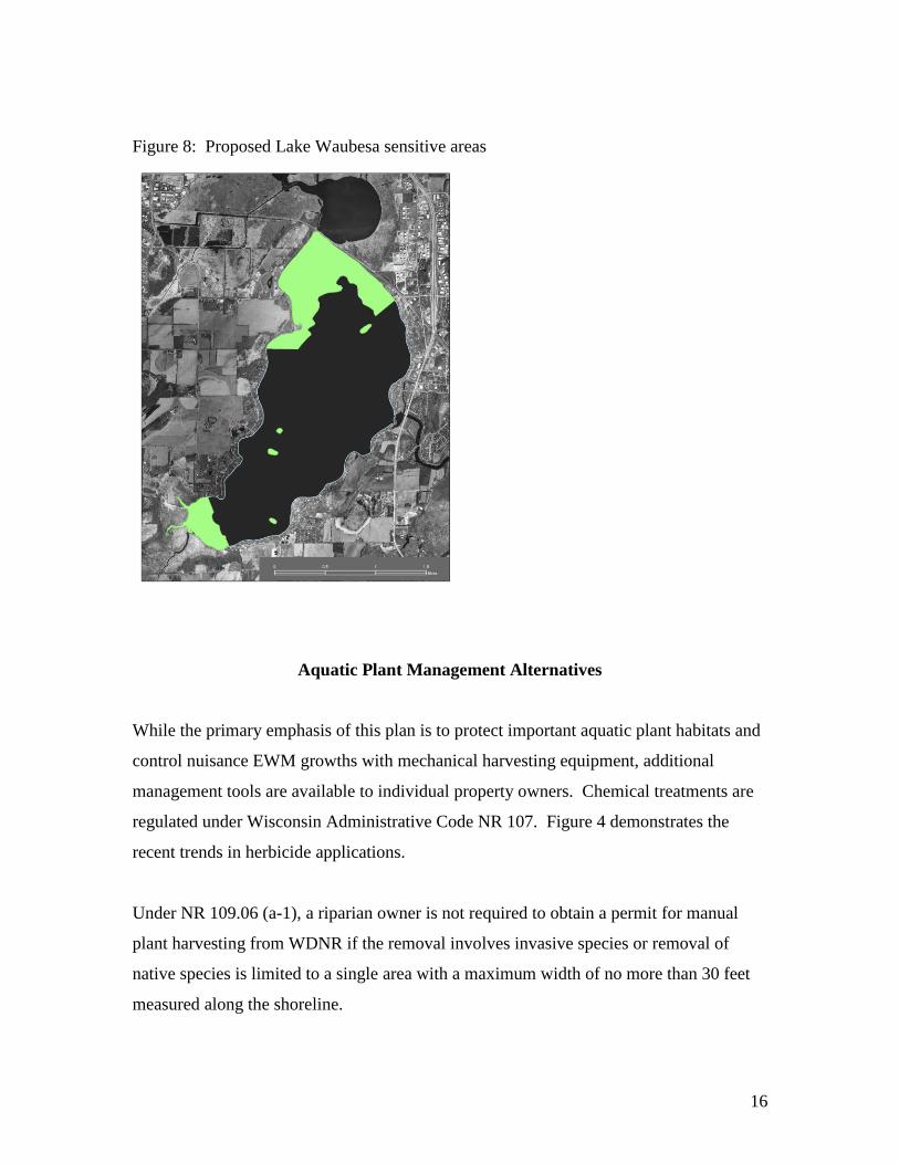
2. Prohibit chemical herbicide treatments within Sensitive Areas (see Figure 8)
except in areas where monotypic stands of EWM occur and goals should include
improving fish habitat and expanding native rooted plants. Sensitive Areas are
relatively undeveloped areas supporting coarse woody debris; floating-leaf plants
including spatterdock (Nuphar variegata) and white water lily (Nymphaea
odorata); and submersed native plant species including clasping-leaf pondweed
(Potamogeton richardsonii), sago pondweed (Struckenia pectinatus), leafy
4
pondweed (Potamogeton foliosus), water stargrass (Heteranthera dubia),
muskgrass (Chara) and wild celery (Vallisneria Americana).
3. Chemical herbicide treatments should focus on the selective control of Eurasian
watermilfoil – EWM (Myriophyllum spicatum).
4. Adopt the “Natural Shorelines” identified in the 1993 (Winkelman and Lathrop)
aquatic plant management plan as Sensitive Areas.
5. Dane County’s mechanical harvesting crews should continue to take steps to
prevent the spread of exotic invaders across Dane County lakes. These steps
include removing any visible plants, mud, debris, water, fish or animals from the
machinery and thoroughly washing the equipment. The fact sheet in Appendix A
is included in the harvesting crews’ operations manual.
Introduction
As required in Wisconsin Administrative Code NR 109.04(d), the purpose of this plan is
to guide mechanical harvesting activities and the effective management of aquatic plants
in Lake Waubesa. This plan also updates a previous aquatic plant management plan
prepared in 1993 (Winkelman and Lathrop). Dane County operates mechanical
harvesters in Lake Waubesa to reduce dense beds of exotic EWM and occasionally exotic
curly-leaf pondweed – CLP (Potamogeton crispus). Native coontail (Ceratophyllum
demersum) beds are targeted when densities undermine recreational uses. Dense stands
of these “weedy” plants have undermined boating access and other recreational uses in
the lake. Harvesting efforts have been designed to enhance important lake management
functions.
Aquatic plant beds in Lake Waubesa have changed significantly since the nineteenth
century. The combination of declining water quality, invasions of non-native carp
(Cyprinus carpio) and weedy plants (EWM and CLP), shoreline development, herbicide
treatments and heavy motorboat traffic have altered the plant communities in the lake
(Nichols and Lathrop 1994). As a result, several high value native species had not been
collected in decades while other native species have declined substantially from the lake.
Lake Waubesa has supported relatively low species richness, a likely symptom of
5
urbanization within the watershed and historic wastewater discharges. More detailed
discussions on the trends and environmental impacts on aquatic plants in Lake Waubesa
and other Yahara Chain of Lakes can be found in Cultural Impacts on Macrophytes in the
Yahara Lakes Since the Late 1800s (Nichols and Lathrop 1994) and Aquatic Plants in
Lake Waubesa: Their Status and Implications for Management (1993).
The primary goals in preparing this plan were to establish long-term realistic objectives
for managing nuisance exotic plant species while protecting valuable native species and
their important habitat functions. While the goal was not to create a comprehensive lake
management plan, aquatic plant community relationships with other aspects of lake and
watershed management cannot be ignored.
Goals
Because Eurasian watermilfoil has dominated the littoral zone for several decades, the
goals for managing Lake Waubesa aquatic plants are to (1) improve recreational access in
the lake, (2) protect Sensitive Areas defined under Wisconsin Administration NR
107.05(3-i) and (3) restore documented declines and possible of high value species [NR
107.08(4)] in the lake including clasping-leaf pondweed (Potamogeton richardsonii),
horned pondweed (Zannichelia palustris), wild celery (Vallisneria Americana) and sago
pondweed (Struckenia pectinatus). Other important native plants that have declined in
Lake Waubesa and also require protection include flat-stem pondweed (P. zosteriformis),
spatterdock (Nuphar variegata), white water lily (Nymphaea tuberosa), muskgrass
(Chara), slender naiad (Najas flexilis), leafy pondweed (Potamogeton foliosus), and
water stargrass (Heteranthera dubia).
Background Information
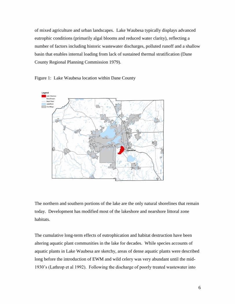
Lake Waubesa (2,080 acres) lies downstream of Lake Monona and upstream of Lake
Kegonsa (Figure 1). The lake has a maximum depth of 38 feet and shoreline length of
9.4 miles. It is third in a series of lakes that were formed as morainic damming of pre-
glacial Yahara River (Day et al. 1985). Excluding the land area that drains into the upper
Yahara Lakes, the direct watershed area surrounding Lake Waubesa is 47.1 square miles
6
of mixed agriculture and urban landscapes. Lake Waubesa typically displays advanced
eutrophic conditions (primarily algal blooms and reduced water clarity), reflecting a
number of factors including historic wastewater discharges, polluted runoff and a shallow
basin that enables internal loading from lack of sustained thermal stratification (Dane
County Regional Planning Commission 1979).
Figure 1: Lake Waubesa location within Dane County
The northern and southern portions of the lake are the only natural shorelines that remain
today. Development has modified most of the lakeshore and nearshore littoral zone
habitats.
The cumulative long-term effects of eutrophication and habitat destruction have been
altering aquatic plant communities in the lake for decades. While species accounts of
aquatic plants in Lake Waubesa are sketchy, areas of dense aquatic plants were described
long before the introduction of EWM and wild celery was very abundant until the mid-
1930’s (Lathrop et al 1992). Following the discharge of poorly treated wastewater into
7
Lake Waubesa during the 1930’s, the maximum depth of aquatic plant growth was only
five feet and continued to decline to only three feet by 1951 (Nichols and Lathrop 1994).
More recently, rooting depths for aquatic plants have increased to at least 11 feet,
reflecting improved water clarity since the 1970’s.
In addition to declining water quality and extensive chemical treatments, other factors
that lead to native plant declines include exotic invasions of common carp, EWM and to a
much lesser extent CLP. Carp were introduced into the Yahara Lakes between 1897 and
1893. Direct impacts of carp include uprooting and roiling the bottom sediments during
feeding and spawning. EWM appeared to have a pronounced impact as native plant
declines coincided with rapid expansion of the exotic plant by 1966 (Nichols and Lathrop
1994). Because they begin their growth early in the year, both EWM and CLP can create
dense canopies before native species emerge from winter dormancy. For approximately a
decade after its introduction, EWM became well established in Lake Waubesa and
remained very abundant until the first noted decline in 1976. Since then, periodic
declines and resurgence of EWM have occurred in Lake Waubesa and in the other
Yahara lakes, a typical sequence found for EWM and other exotic plant invasions
(Nichols 1994, Smith and Barko 1992). Compared with EWM, CLP growth trends have
been insignificant and have had minor impacts on native plants in Lake Waubesa.
EWM has undermined boating, fishing, water skiing, and swimming in Lake Waubesa.
This is a common pattern found throughout the United States when EWM enters a lake
(Nichols 1994, Smith and Barko 1990). In addition to human use impairments, the
ecological side effects of dense stands of EWM and other weedy plants on fisheries have
been extensively evaluated (Engel 1987, Dibble et al. 1996, Olson et al. 1998, Savino and
Stein 1982, Trebitz et al. 1997). Dense EWM beds have been linked with slow fish
growth rates in some lakes. However the effects of EWM on panfish and predator
growth rates in Lake Monona are not significant. Growth rates and production of a
variety of sportfishes in Lake Waubesa have been considered excellent for decades. In
Lake Mendota, EWM in may have contributed to the disappearance of nongame fishes
including banded killifish (Fundulus diaphanus), blackstripe topminnow (Fundulus
8
notatus) blackchin shiner (Notropis heterodon), blacknose shiner (Notropis heterolepis),
pugnose shiner (Notropis anogenus), and tadpole madtom (Noturus gyrinis) (Lyons
1996). Other factors such as shoreline development and piers may have also affected
these species due to their strong affinity for nearshore aquatic plant habitat (Garrison et
al. 2005, Bryan and Scarnecchia 1992, Becker 1983, Gaumitz 2005, Marshall and Lyons
2008). Heavy motorboat traffic has also been linked to declining aquatic plant habitat in
lakes (Asplund and Cook 1997).
While nongame fish declines likely occurred, Lake Waubesa supports diverse warmwater
fisheries including longnose gar (Lepisosteus osseus), bowfin (Amia calva), northern pike
(Esox lucius), common carp (Cyprinus carpio), golden shiner (Notemigonus crysoleucas),
spottail shiner (Notropis hudsonius), bluntnose minnow (Pimephales notatus), fathead
minnow (Pimephales promelas), white sucker (Catostomus commersoni), black bullhead
(Ameiurus melas), yellow bullhead (Ameiurus melas), brown bullhead (Ameiurus
nebulosus), channel catfish (Ictalurus punctatus) brook silverside (Labedesthes sicculus),
white bass (Morone chrysops), rock bass (Ambloplites rupestris), green sunfish (Lepomis
cyanellus), pumpkinseed (Lepomis gibbosus), bluegill (Lepomis macrochirus),
smallmouth bass (Micropterus dolomieu), largemouth bass (Micropterus salmoides),
white crappie (Pomoxis annularis), black crappie (Pomoxis nigromaculatus), yellow
perch (Perca flavescens), logperch (Percina caprodes), Iowa darter (Etheostoma exile),
walleye (Stizostediun vitreum) and freshwater drum (Aplodinotus grunniens) – (Day et al.
1985).
High mercury in lake sediments from historic wastewater discharges is a concern due to
bioaccumulation of methyl-mercury in fish and the fish consumption advisory. While
mercury in sediments are at higher levels most lakes in the state, mercury levels in fish
have consistently been lower than those found in many other lakes with lower alkalinities
and higher rates of anaerobic bacterial conversion of inorganic mercury to methyl-
mercury. Lakes with lower alkalinities (closer to neutral or below 7 on the pH scale) are
typically found in northern Wisconsin. They are often referred to as northern shield
lakes. These lakes are found in soils that have low amounts of calcium and magnesium,
9
which results in lower alkalinities. Most mercury found in these northern lakes is a result
of mercury contribution from rain and snow. Anaerobic (low or no oxygen) conditions
then facilitate the process of methylation of mercury, or changing its form to one that can
readily enter the food chain.
Recent Chemical and Harvesting Aquatic Plant Management Records
Dane County’s mechanical harvesting program typically runs from mid-May to mid-
August each summer. Harvesting is not conducted in water less than three feet deep.
Harvesting staff at times will operate the machines in waters shallower than three feet,
but only to scoop up floating plants. The cutting head of the harvesters are lifted up so as
to avoid disturbing sediment during these floating plant collection times. Priority
harvesting includes emergency flood relief, boat navigation and public access areas such
as beaches and boat landings. Harvested plants are removed to a local composting site.
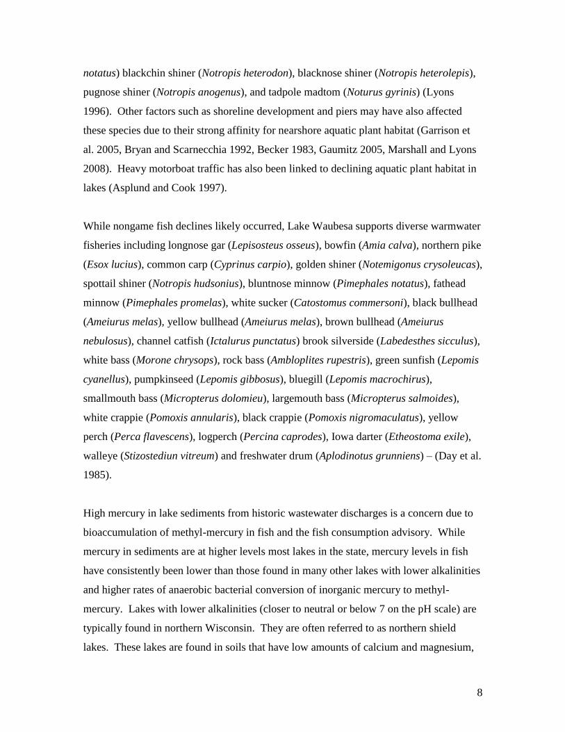
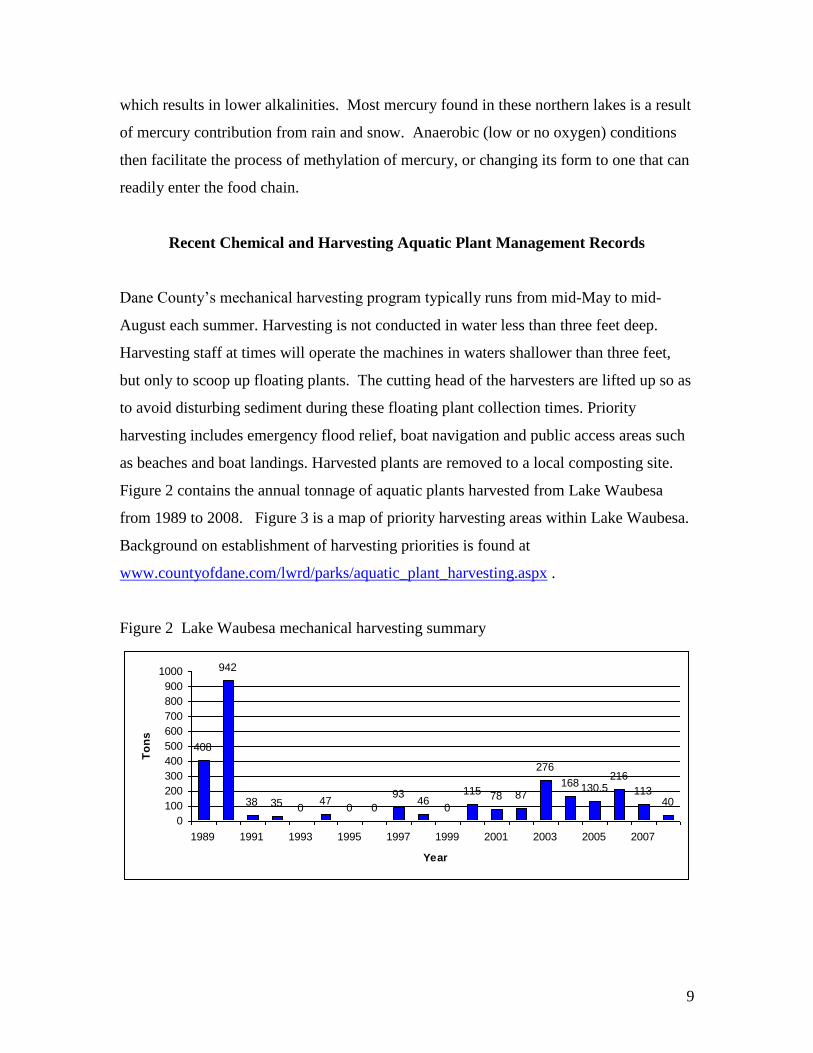
Figure 2 contains the annual tonnage of aquatic plants harvested from Lake Waubesa
from 1989 to 2008. Figure 3 is a map of priority harvesting areas within Lake Waubesa.
Background on establishment of harvesting priorities is found at
www.countyofdane.com/lwrd/parks/aquatic_plant_harvesting.aspx .
Figure 2 Lake Waubesa mechanical harvesting summary
408
942
38 35 047
0 0
9346
0
115 78 87
276
168 130.5216
11340
0
100
200
300
400
500
600
700
800
900
1000
1989 1991 1993 1995 1997 1999 2001 2003 2005 2007
Year
To
ns
10
Figure 3: Lake Waubesa Mechanical Harvesting Priority Areas
11
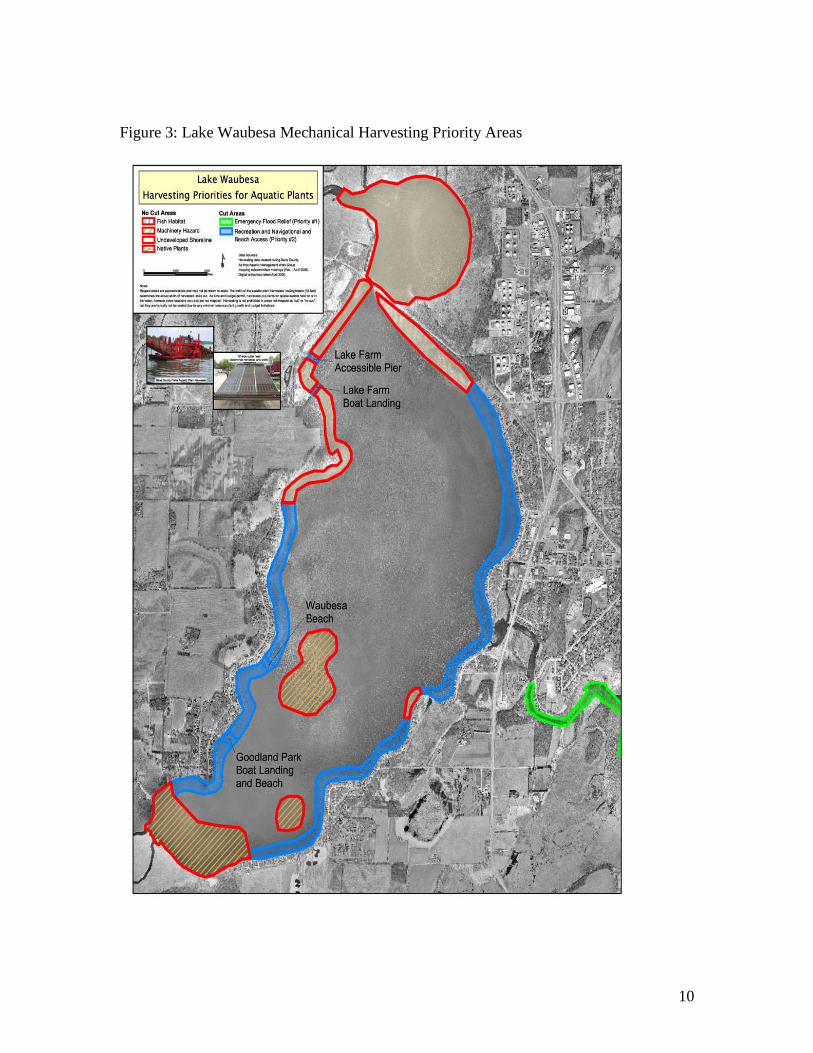
While Dane County operates mechanical harvesting equipment in water deeper than three feet, a
number of the private riparian property owners collectively hire one or more certified chemical
applicators each year for nuisance plant control in shallower waters. These chemical herbicide
applications are for individual property owners and include areas adjacent to their docks.
Chemical applications have been a controversial issue for managing aquatic plants in the Yahara
lakes since the 1970s, primarily due to concerns over potential unknown ecological and health
effects. Potential adverse impacts of chemical applications include damage to non-target
organisms and change to ecosystem functions. In general, chemical applications have been fairly
consistent over the last few decades and treatment areas have been relatively modest in relation
to the total littoral zone in the lake. One concern has been that herbicide treatments focus on
near shore plant communities where most of the native plants occur. Figure 4 lists total littoral
zone acres treated annually for EWM and filamentous algae from 1980 to 2007.
Figure 4: Acres chemically treated in Lake Waubesa by private entities
Acres Treated in Lake Waubesa
0
2
4
6
8
10
12
14
1980
'
1982
'
1984
'
1986
'
1988
'
1990
'
1992
'
1994
'
1996
'
1998
'
2000
'
2002
'
2004
'
2006
'
Year
acre
s
12
2008 Aquatic Plant Survey Update
Methods
Jen Hauxwell, a research scientist with the Wisconsin Department of Natural Resources
(WDNR) Bureau of Integrated Science Services, developed the point intercept sampling
protocol. The point intercept method involves a large number of sampling sites that are
distributed equidistantly across a lake. In each lake, sampling determines the maximum
depth of rooted plant growth and greater depths are ultimately ignored. GPS units were
used to locate the sites and double-headed rakes were used to collect aquatic plants. Two
forms of sampling rakes were used. The pole rake was used for sampling aquatic plants
up to 15 ft (4.6 m) and rope rake was used to sample deeper areas. Density ratings from
1-3 were determined by the amount of plant material in the two-headed rake. Plants that
were observed near the boat but were not collected in the rake were also noted. Samples
of each species found in a lake were collected, pressed and submitted as voucher
specimens to the UW Madison Herbarium. Secchi measurements were collected during
each sampling day and these were transformed to Trophic State Index values (TSI). The
TSI is a lake water quality index ranging from 0 to 100. Values greater than 50 indicate
eutrophic or high fertility.
Statistical analysis included the following:
Frequency of occurrence within vegetated sites (number of times a species
was found divided by the total number of vegetated sites.
Relative frequency of plant species collected (describes each species
contributing a certain percentage of the whole aquatic plant community).
The Simpson Diversity Index is a nonparametric estimator of community
heterogeneity. The Simpson Diversity Index range is from 0 to 1 with lower
diversity reflected in scores closer to 1.
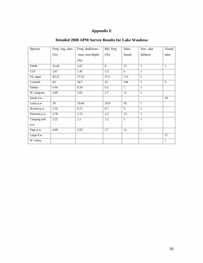
Detailed statistical results appear in Appendix B. Appendix E contains detailed plant
survey results.
13
WDNR provided the sampling grids and Excel spreadsheet software for data entry and
analysis. A more detailed sampling description can be found in Baseline Monitoring of
Aquatic Macrophytes (Hauxwell 2006).
Results and Discussion
The point intercept survey was conducted on July 8, 11, 15 and 18, 2008. Secchi depths
ranged from 3.6 feet (TSI = 59) and 5.5 feet (TSI = 53) and reflected moderate
Cyanobacteria blooms. Aquatic plants were sampled at a total of 520 GPS points across
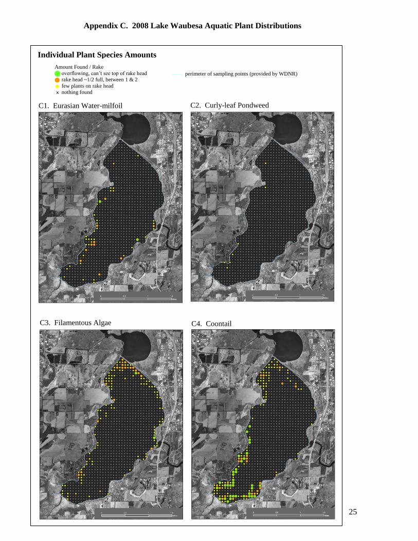
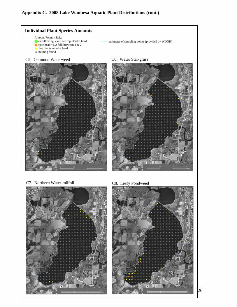
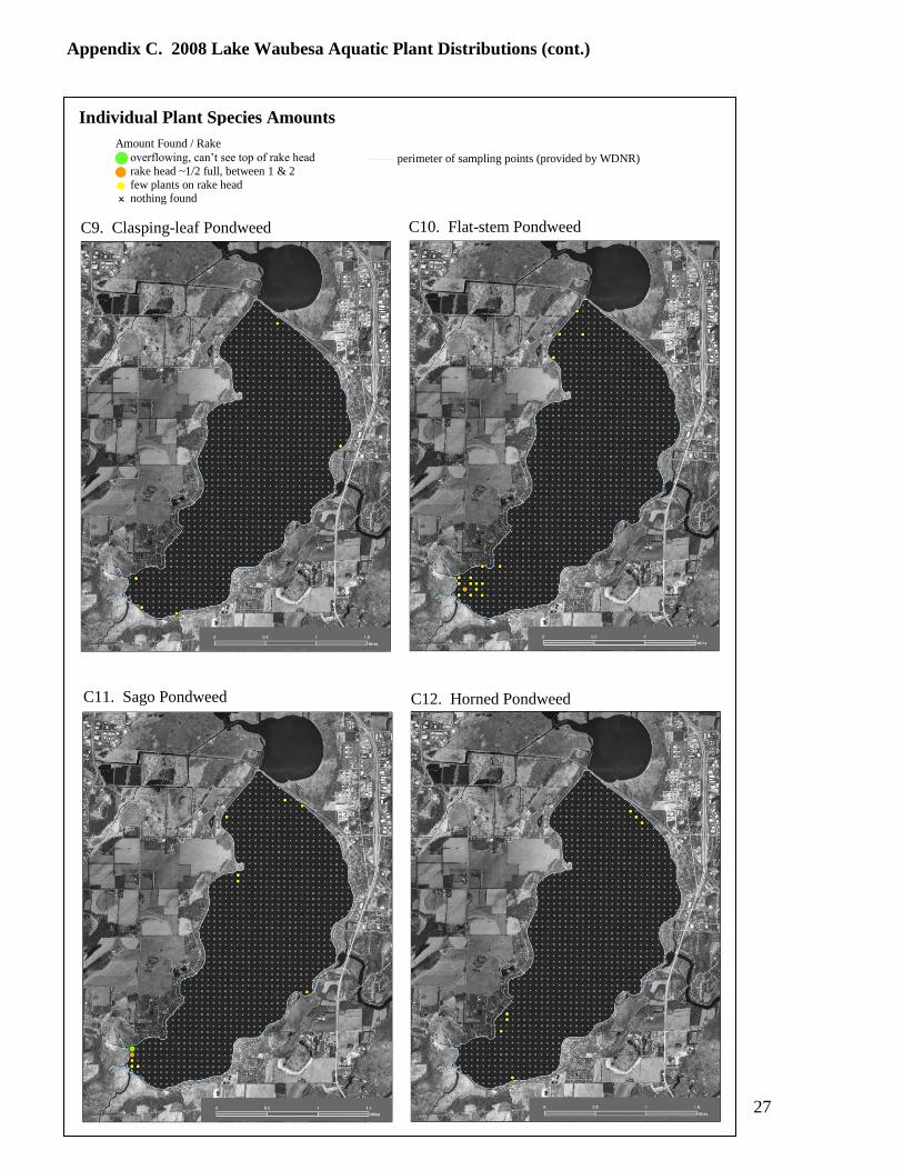
the lake. The maps in Appendix C display aquatic plant distributions in Lake Waubesa,
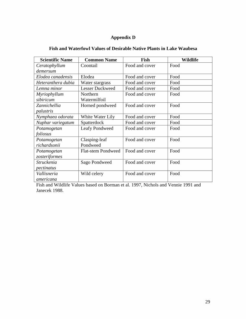
and Appendix D summarizes fish and waterfowl values of native plants in the lake.
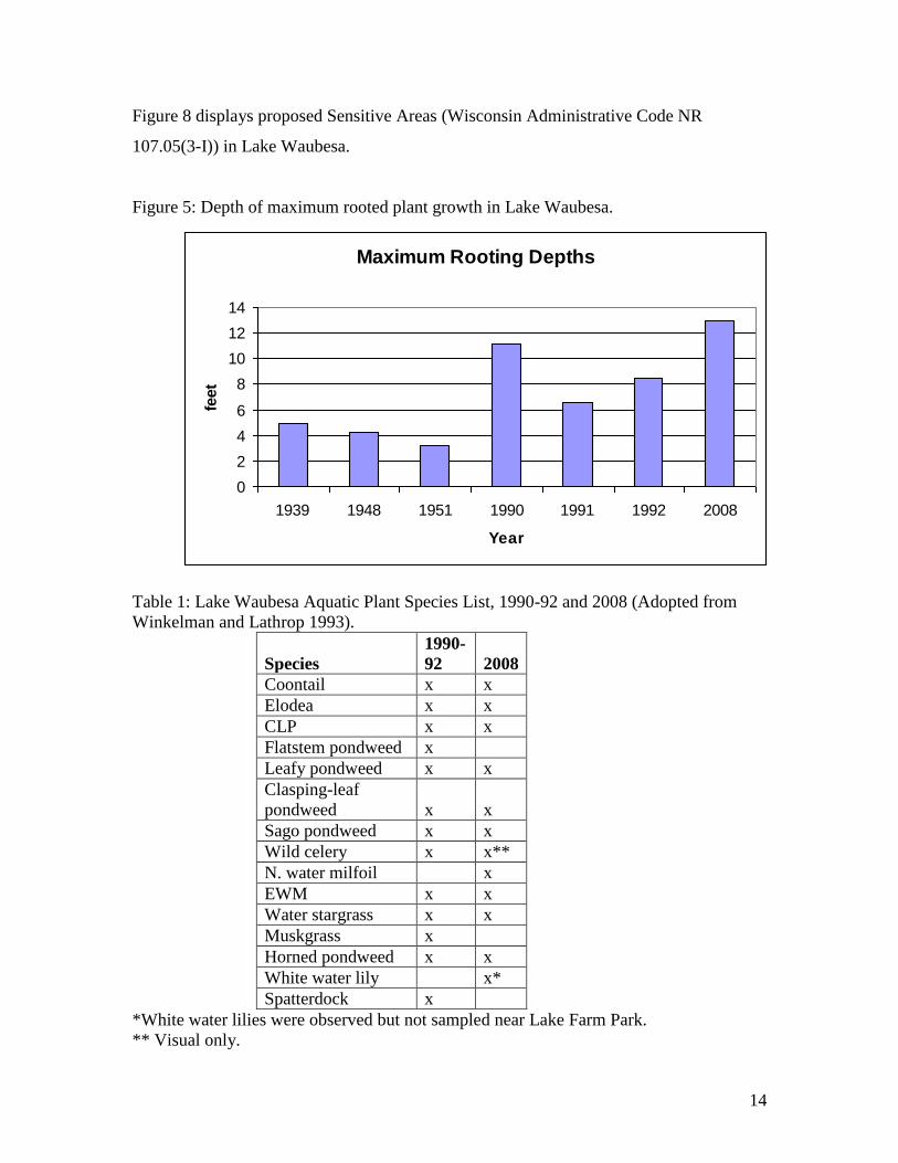
Results of the 2008 plant survey included that a few plants were found at a maximum
depth of 13 feet but most plant collections were less than 10 feet, more consistent with
previous surveys. The 2008 survey maximum rooting depth is compared with previous
reports for Lake Waubesa in Figure 5 (adapted from Winkelman and Lathrop 1993).
Total species richness was similar during the two major sampling periods, the early
1990’s and 2008. However, coontail comprised a much larger percentage of the aquatic
plant community in 2008 (relative frequency of 35% compared to just 9% for EWM) and
likely reflects the decline in EWM that year. Simpson Diversity Index was moderately
low at 0.78. Values closer to 1 indicate greater aquatic plant community diversity.
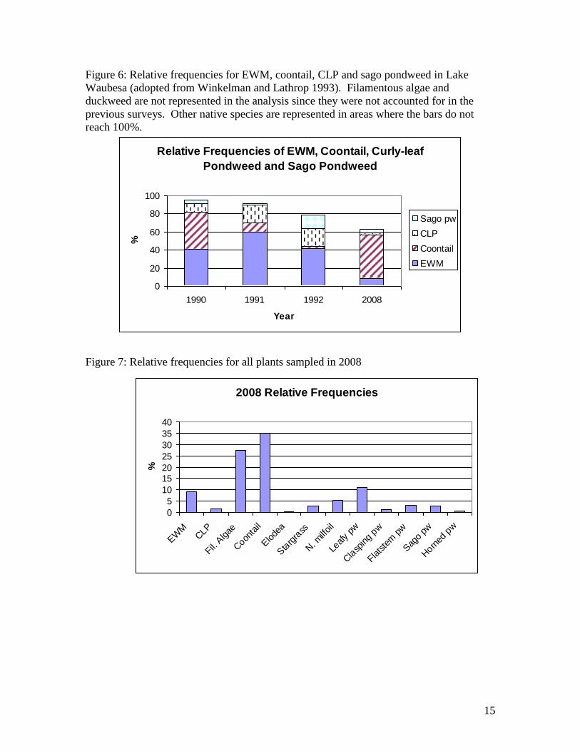
Table 1 lists aquatic plant species collected 1990-92 and 2008. Adapted from
Winkelman and Lathrop (1993), Figure 6 compares relative frequencies for EWM,
coontail, CLP and sago pondweed. These four species were dominant during the 1990’s
but in 2008 other species appeared to become more common including water stargrass,
leafy pondweed flatstem pondweed and northern watermilfoil. EWM was the dominant
rooted plant in most years except 1990 when coontail was collected at about the same
frequency and in 2008 when it clearly dominated in the wake of the EWM decline.
Relative frequency data for all species collected in 2008 are displayed in Figure 7,
including filamentous algae and duckweed. Previous surveys excluded these two plant
groups but filamentous algae were frequently collected in 1992 rake-head samples.
14
Figure 8 displays proposed Sensitive Areas (Wisconsin Administrative Code NR
107.05(3-I)) in Lake Waubesa.
Figure 5: Depth of maximum rooted plant growth in Lake Waubesa.
Maximum Rooting Depths
0
2
4
6
8
10
12
14
1939 1948 1951 1990 1991 1992 2008
Year
feet
Table 1: Lake Waubesa Aquatic Plant Species List, 1990-92 and 2008 (Adopted from
Winkelman and Lathrop 1993).
Species
1990-
92 2008
Coontail x x
Elodea x x
CLP x x
Flatstem pondweed x
Leafy pondweed x x
Clasping-leaf
pondweed x x
Sago pondweed x x
Wild celery x x**
N. water milfoil x
EWM x x
Water stargrass x x
Muskgrass x
Horned pondweed x x
White water lily x*
Spatterdock x
*White water lilies were observed but not sampled near Lake Farm Park.
** Visual only.
15
Figure 6: Relative frequencies for EWM, coontail, CLP and sago pondweed in Lake
Waubesa (adopted from Winkelman and Lathrop 1993). Filamentous algae and
duckweed are not represented in the analysis since they were not accounted for in the
previous surveys. Other native species are represented in areas where the bars do not
reach 100%.
Relative Frequencies of EWM, Coontail, Curly-leaf
Pondweed and Sago Pondweed
0
20
40
60
80
100
1990 1991 1992 2008
Year
%
Sago pw
CLP
Coontail
EWM
Figure 7: Relative frequencies for all plants sampled in 2008
2008 Relative Frequencies
0
5
10
1520
25
30
35
40
EW
MCLP
Fil. A
lgae
Coon
tail
Elode
a
Sta
rgra
ss
N. m
ilfoil
Leafy
pw
Cla
sping p
w
Flatste
m p
w
Sag
o pw
Horn
ed p
w
%
16
Figure 8: Proposed Lake Waubesa sensitive areas
Aquatic Plant Management Alternatives
While the primary emphasis of this plan is to protect important aquatic plant habitats and
control nuisance EWM growths with mechanical harvesting equipment, additional
management tools are available to individual property owners. Chemical treatments are
regulated under Wisconsin Administrative Code NR 107. Figure 4 demonstrates the
recent trends in herbicide applications.
Under NR 109.06 (a-1), a riparian owner is not required to obtain a permit for manual
plant harvesting from WDNR if the removal involves invasive species or removal of
native species is limited to a single area with a maximum width of no more than 30 feet
measured along the shoreline.
17
Dredging is generally not considered to be a practical option due to high costs. Limited
dredging efforts have been publicly-funded for selected boat ramps and river channel
access. Dredging as a form of aquatic plant management would require a Chapter 30
permit from WDNR. Historic dredging has already resulted in significant losses and
modifications of littoral areas.
Another alternative is the use of aquatic weevils. Weevils have been demonstrated to
control EWM in laboratory and enclosure studies (Mazzei et al. 1999, Sheldon and Creed
1995). A EWM decline in Fish Lake occurred in 1994, coinciding with evidence of
weevil damage (Lillie 2000), however EWM rebounded a few years later and high
densities continue in the presence of the insect. More detailed discussions on aquatic
plant management alternatives can be found in Cooke et al. (2005) and Petty (2005).
Specific Alternatives for Lake Waubesa
1) No treatment: Rejecting all types of aquatic plant management does not appear
realistic, given the extent of EWM coverage and heavy recreational needs across
the lake.
2) Biological control: This method does not appear realistic at this time. Research
findings suggest that weevils are difficult and expensive to establish in a lake and
effectiveness has been mixed. Research will no doubt continue to assess
biological controls. If a method proves viable as a possible control method, it
will be evaluated as a potential control method for Lake Monona or other Yahara
Lakes.
3) Chemical control: Herbicide use should be restricted to agents selective at
controlling EWM. 2, 4-D is the likely agent given the partial selectivity for
controlling EWM. However, several valuable native plants including water lilies
can be damaged from 2, 4-D so WDNR permit applications should be carefully
screened to avoid loss of already declining native plants. Whole-lake chemical
applications in Lake Waubesa are not feasible given its enormous size and
discharge. The U.S. Army Corps of Engineers (COE) is working on using
herbicides to control exotic plants while not adversely impacting and/or
18
enhancing native plants. Dane County is coordinating research efforts to assess
early season chemical treatments in parts of Turville Bay of Lake Monona.
4) Manual - hand removal: Manually removing plants around piers and swimming
areas is a viable option. However, property owners should be educated about the
importance of high value native species so that their efforts should focus on
weedy exotics such as EWM. Sensitive Areas should be avoided and all plants
that are cut should be removed.
5) Mechanical harvesting: Given the extent of EWM throughout the Yahara Lakes,
mechanical harvesting provides effective temporary access through the dense
monotypic beds as well as providing habitat improvements. Sensitive Areas
should be avoided to prevent loss of floating-leaf plants and other high value
species along the north and south ends of the lake and other publicly owned
shorelines.
6) Physical controls: Hydraulic dredging can be an option for removing the nutrient
rich sediments within designated navigation channels. This method has the
greatest potential for long-term control but can be initially expensive. Whole lake
dredging is unrealistic given the vast littoral areas affected by EWM. Fabrics are
another physical control method but rarely used by property owners because of
the labor of installation and maintenance. During local demonstrations at Tenney
Locks, problems arose due to gas collection under the fabric and attached
filamentous algae growth. Drawdown is infrequently used in Wisconsin for
aquatic plant management and would not likely affect the weedy stands of EWM
and coontail beyond the nearshore areas. Nearshore valuable native plants could
be negatively affected by a drawdown and water replacement may be an issue
during a drought cycle.
7) WDNR management options for Wisconsin lakes can be found at this
website: www.danewaters.com/pdf/2006/management_options_aq_plants.pdf
19
References
Asplund, T.A. and C.M. Cook. 1997. Effects of motor boats on submersed aquatic
macrophytes. Lake and Reserv. Mgmt. 13:1-12.
Borman, S., R. Korth and J. Temte. 1997. Through the looking glass: a field guide to
aquatic plants. Wisconsin Department of Natural Resources Pub FH-207-97.
Bryan, M.D. and D.L. Scarnecchia. 1992. Species richness, composition, and abundance
of fish larvae and juveniles inhabiting natural and developed shorelines of a
glacial Iowa lake. Environmental Biology of Fishes 35:329-341.
Cooke, D.G., E.B.Welch, S.A. Peterson and P.R. Newroth. 2005. Restoration and
management of lakes and reservoirs. Third edition. Taylor and Francis/CRC
Press. 616p.
Dane County Regional Planning Commission. 1979. Dane County Water Quality Plan:
Appendix B.
Day, E.A., G.P. Grzebieneak, K.M. Osterby, C.L. Brynildson. 1985. Surface water
resources of Dane County. Wisconsin Department of Natural Resources lake and
stream classification project. Second edition. p. 15-17.
Dibble, E.D., K. J. Killgore and S.L. Harrel. 1996. Assessment of fish-plant interactions.
American Fisheries Society Symposium 16:357-372.
Engel, S. 1987. The restructuring of littoral zones. Lake Reserv. Manage. 3: 235-242.
Fassett, N.C. 1975. A manual of aquatic plants. The University of Wisconsin Press.
Garrison, P.J., D.W. Marshall, L. Stremick-Thompson, P.L. Cicero and P.D. Dearlove.
2005. Effects of pier shading on littoral zone habitat and communities in Lakes
Ripley and Rock, Jefferson County, Wisconsin. PUB-SS-1006.
Gaumitz, L. 2005. Shoreline sentinels. Wisconsin Natural Resources. 29:22-28.
Janecek, J.A. 1988. Literature review on fishes interactions with aquatic macrophytes
with special reference to the Upper Mississippi River System. U.S. Fish and
Wildlife Service. Upper Mississippi River Conservation Committee. Rock Island,
Illinois.
Lathrop, R.C. 1992. Lake Mendota and the Yahara River chain. pp. 71-98. In J.F.Kitchell
(ed.)Food Web Research and Its Application to Lake Management: A Case Study
of Lake Mendota, Wisconsin. Springer-Verlag, New York. 553 pp.
Lathrop, R.C. 1990. Response of Lake Mendota (Wisconsin USA) to decreased
phosphorus loadings and the effect on downstream lakes. Verh. Internat. Verein.
Limnol. 24:457-463.
Lyons, J. 1989. Changes in the abundance of small littoral zone fishes in Lake Mendota,
Wisconsin. Can. J. Zool. 67:2910-2916.
Nichols, S.A. and R.C. Lathrop. Cultural impacts on macrophytes in the Yahara lakes
since the late 1880s. Aquat. Bot. 47:225-247.
Nichols, S.A. 1994. Evaluation of invasions and declines of submersed macrophytes for
the Upper Great Lakes Region. Aquat. Bot. 41:225-252.
Nichols, S.A. and J.G. Vennie. 1991. Attributes of Wisconsin Lake Plants. Wisconsin
Geological and Natural History Survey. Information Circular 73.
Savino, J.F. and R.A. Stein. 1982. Predator-prey interaction between largemouth bass and
bluegills as influenced by simulated, submersed vegetation. Transactions of the
American Fisheries Society. 111: 255-265.
20
Smith, C.S. and J.W. Barko. 1992. Submersed macrophyte invasions and declines.
Waterways Experiment Station, US Army Corps of Engineers, Aquatic Plant
Control Research Program Bulletin A-92-1, Vicksburg, MS.
Smith, C.S. and J.W. Barko. 1990. Ecology of Eurasian watermilfoil. J. Aquat. Plant
Manage. 28:55-64.
Trebitz, A., S. Carpenter, P. Cunningham, B. Johnson, R. Lillie, D. Marshall, T. Martin,
R. Narf, T. Pellett, S. Stewart, C. Storlie and J. Unmuth. 1997. A model of
bluegill-largemouth bass interactions in relation to aquatic vegetation and its
management. Ecological Modeling. 94: 139-156.
Wisconsin Department of Natural Resources. 1990. Environmental Assessment – Aquatic
Plant Management (NR 107) Program. 3rd
Edition. 213 p.
Winkelman, J. and R.C. Lathrop. 1993. Aquatic Plants in Lake Waubesa: Their Status
and Implications for Management. Wisconsin Department of Natural Resources
62 p.
GLOSSARY
Alleopathy Chemical suppression of a plant on another plant species.
Biomanipulation A technique involving using predatory fish to reduce the number of
fish that feed on zooplankton.
Chlorophyll a The photosynthetic pigment in plant life. Concentrations in lake
water are related to the planktonic algal growth and fertility.
Columnaris Bacterial infection of fish that especially occurs when they are
stressed. The disease is highly contagious to fish and typically
enters through gills, mouth or small skin wounds.
Cyanobacteria Blue-green algae: a group of algae that are often associated with
nuisance lake blooms. Certain species can produce toxins that can
cause illness and even death in animals and humans. Blue-green
algae can fix nitrogen from the atmosphere and thus are often
found when phosphorus levels in water are high.
Emergent plants Species with leaves that extend above the water surface and are
usually found in shallow water.
Eutrophication The process of increasing lake fertility, often accelerated by
humans (cultural eutrophication).
Eutrophic Description for a very productive and fertile lake.
Floating-leaf plants Rooted plants with leaves that float on the water surface such as
water lilies and native several pondweeds.
21
Filamentous algae Algae that forms filaments or mats which attach to the bottom
sediments, rooted plants, piers, etc.
Hectare A unit of measure which is equivalent to 2.47 acres.
Herptiles A broad group of cold blooded animals including turtles and
amphibians.
Hypereutrophic A very nutrient enriched lake characterized by severe and
dominant algal blooms and very poor water quality.
Hypolimnion The deeper stratified layer in a lake that typically remains cold and
isolated from the atmosphere.
Hypolimnetic See hypolimnion.
Intolerant Species sensitive to degraded habitat and water quality.
Limnologist A specialist in the study of freshwater ponds and lakes.
Littoral Zone Shallow areas of a lake where most of the rooted aquatic plants are
found.
Macrophytes Rooted plants typically found growing the littoral zone of lakes.
They produce oxygen and provide food and cover for lake
organisms.
Mesotrophic Intermediate description for lake fertility between Eutrophic (very
fertile) and Oligotrophic (infertile) waters.
Monotypic Dominance of a single plant species.
Oligotrophic Lakes that are relatively infertile with low levels of plankton and
rooted plants.
Pelagic The open water zone of a lake outside of the littoral zone.
Phytoplankton Free-floating algae that form the base of lake food webs.
Planktivores Fish that typically feed on zooplankton.
Point Source Wastewater or source of pollution with a defined discharge point
such as a discharge pipe.
22
Secchi disc An eight-inch diameter disc with four alternating quadrants of
black and white. It is lowered into a lake on a rope and used to
measure light penetration. Lakes are infertile (oligotrophic) if the
depth you can see the disc are great. Lakes are fertile (eutrophic)
if the disc disappears quickly.
Species Richness An indicator of species diversity.
Thermocline Metalimnion or transitional zone between the epilimnion (upper
part) and the hypolimnion (bottom). This portion of a lake is
where the temperature changes most rapidly and in most waters is
found around 20 feet or deeper.
Trophic State Index An empirical water quality scale for lakes based on total
phosphorus, secchi and chlorophyll-a.
Turions The over-wintering bud produced by aquatic plants.
23
Appendix A
BOAT AND HARVESTER DISINFECTION AND VEGETATION REMOVAL LAWS Dane County Lake Management Guidelines
We already have many exotic species in our waters, and while it may seem somewhat ridiculous to remove plants that are already a problem, and found in most if not all the county waters, the future most likely will find new problems being identified. Frequently, exotics become established because you do not realize that you even have one of these “new visitors” on your boat. It is now State Law to remove plant materials and water from watercrafts and equipment. We follow the State Law Guidelines developed by the Wisconsin Department of Natural Resources (DNR). Their guidelines are consistent with nationally accepted set of prevention steps. Following these guidelines is important for three reasons. It sets a good example to the public, it insures that we are not responsible for, or contributing to, the spread of aquatic exotics and due to recent legislative changes may also be against the law to transport or spread invasive species. The following steps shall be taken every time a boat, equipment or gear is moved between waters to avoid transporting invasive species and/or pathogens.
Inspect and remove aquatic plants, animals, and mud from your boat, trailer, equipment and gear.
Drain all water, if applicable, from your boat, motor, live well, bilge, transom wells, as well as from your equipment and gear, including but not limited to tracked vehicles, barges, silt or turbidity curtain, hoses, sheet pile and pumps.
Dispose of unwanted aquatic plants and animals in an appropriate way. Try and place them where normal clean-up activities can occur or so as to not contribute to an unsightly condition.
Disinfect – We will disinfect all harvesters and equipment whenever equipment leaves or enters the Yahara River Chain of Lakes or when moving from one waterbody to another waterbody outside the Yahara River Chain of Lakes. Disinfecting: Pressure wash and treat all surfaces with a bleach solution - using 0.5 oz of household bleach per gallon of water. At least a 10-minute contact time is recommended. Bleach contains chlorine and the following precautions should be taken.
** Wear eye protection, rain gear and gloves if spraying. ** Stay upwind of the spray. Chlorine is corrosive to metal and rubber and toxic to fish at these concentrations so it needs to be well rinsed after the 10 minute contact time (sodium thiosulfate can also be used to neutralize chlorine – at three grams per gallon of water). Rinsing should be done so as to prevent runoff to a surface water. The following guidance is directly from the DNR Manual Code (9183.1). Boats, trailers and live wells Remove organic material from boats, trailers, and live wells. Drain water from live wells, bilges and pumps. The outside and inside of the boat, trailer, live wells, bilges and pumps should be sprayed with the disinfection solution and left wet for the appropriate contact time. The inside of the live wells, bilges and pumps should be made to contact the solution for the appropriate contact time as well. Run pumps so they take in the disinfection solution and make sure that the solution comes in contact with all parts of the pump and hose. The boat, trailer, bilges, live well, and pumps should be rinsed with clean water or water from the next waterbody after the appropriate contact time. Every effort should be made to keep the disinfection solution and rinse water out of surface waters. Pull the boat and trailer off the ramp and onto a fairly level area and away from street drains to minimize potential runoff into surface waters.
24
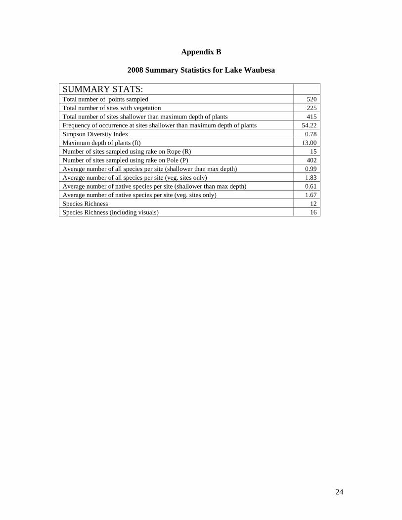
Appendix B
2008 Summary Statistics for Lake Waubesa
SUMMARY STATS:
Total number of points sampled 520
Total number of sites with vegetation 225
Total number of sites shallower than maximum depth of plants 415
Frequency of occurrence at sites shallower than maximum depth of plants 54.22
Simpson Diversity Index 0.78
Maximum depth of plants (ft) 13.00
Number of sites sampled using rake on Rope (R) 15
Number of sites sampled using rake on Pole (P) 402
Average number of all species per site (shallower than max depth) 0.99
Average number of all species per site (veg. sites only) 1.83
Average number of native species per site (shallower than max depth) 0.61
Average number of native species per site (veg. sites only) 1.67
Species Richness 12
Species Richness (including visuals) 16
25
Appendix C. 2008 Lake Waubesa Aquatic Plant Distributions
C1. Eurasian Water-milfoil
overflowing, can’t see top of rake head
rake head ~1/2 full, between 1 & 2
few plants on rake head nothing found
Amount Found / Rake
Individual Plant Species Amounts
perimeter of sampling points (provided by WDNR)
C3. Filamentous Algae
C2. Curly-leaf Pondweed
C4. Coontail
26
Appendix C. 2008 Lake Waubesa Aquatic Plant Distributions (cont.)
C5. Common Waterweed
overflowing, can’t see top of rake head
rake head ~1/2 full, between 1 & 2 few plants on rake head
nothing found
Amount Found / Rake
Individual Plant Species Amounts
perimeter of sampling points (provided by WDNR)
C7. Northern Water-milfoil
C6. Water Star-grass
C8. Leafy Pondweed
27
Appendix C. 2008 Lake Waubesa Aquatic Plant Distributions (cont.)
C9. Clasping-leaf Pondweed
overflowing, can’t see top of rake head
rake head ~1/2 full, between 1 & 2
few plants on rake head nothing found
Amount Found / Rake
Individual Plant Species Amounts
perimeter of sampling points (provided by WDNR)
C11. Sago Pondweed
C10. Flat-stem Pondweed
C12. Horned Pondweed
28
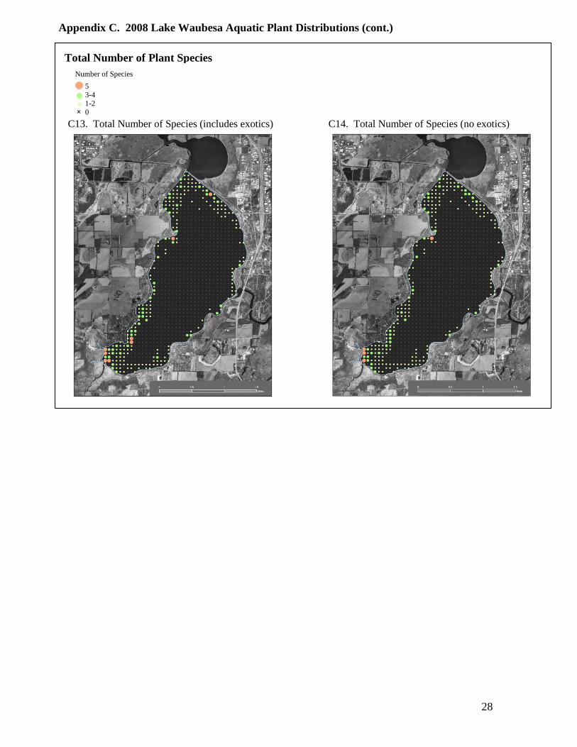
Appendix C. 2008 Lake Waubesa Aquatic Plant Distributions (cont.)
C13. Total Number of Species (includes exotics) C14. Total Number of Species (no exotics)
Total Number of Plant Species
5
3-4 1-2
0
Number of Species
29
Appendix D
Fish and Waterfowl Values of Desirable Native Plants in Lake Waubesa
Scientific Name Common Name Fish Wildlife
Ceratophyllum
demersum
Coontail Food and cover Food
Elodea canadensis Elodea Food and cover Food
Heteranthera dubia Water stargrass Food and cover Food
Lemna minor Lesser Duckweed Food and cover Food
Myriophyllum
sibiricum
Northern
Watermilfoil
Food and cover Food
Zannichellia
palustris
Horned pondweed Food and cover Food
Nymphaea odorata White Water Lily Food and cover Food
Nuphar variegatum Spatterdock Food and cover Food
Potamogetan
foliosus
Leafy Pondweed Food and cover Food
Potamogetan
richardsonii
Clasping-leaf
Pondweed
Food and cover Food
Potamogetan
zosteriformes
Flat-stem Pondweed Food and cover Food
Struckenia
pectinatus
Sago Pondweed Food and cover Food
Vallisneria
americana
Wild celery Food and cover Food
Fish and Wildlife Values based on Borman et al. 1997, Nichols and Vennie 1991 and
Janecek 1988.
30
Appendix E
Detailed 2008 APM Survey Results for Lake Waubesa
Species Freq. veg. sites
(%)
Freq. shallower –
max. root depth
(%)
Rel. freq.
(%)
Sites
found
Ave. rake
fullness
Visual
sites
EWM 16.44 2.67 9 37 1 1
CLP 2.67 1.45 1.5 6 1
Fil. algae 50.22 27.23 27.5 113 1
Coontail 64 34.7 35 144 2 5
Elodea 0.44 0.24 0.2 1 1
W. stargrass 4.89 2.65 2.7 11 1
Small d.w. 18
Leafy p.w. 20 10.84 10.9 45 1
Horned p.w. 1.33 0.72 0.7 3 1
Flatstem p.w. 5.78 3.13 3.2 13 1
Clasping leaf
p.w.
2.22 1.2 1.2 5 1
Sago p.w. 4.89 2.65 2.7 11 1
Large d.w. 17
W. celery 1