Embed Size (px)
Citation preview
1
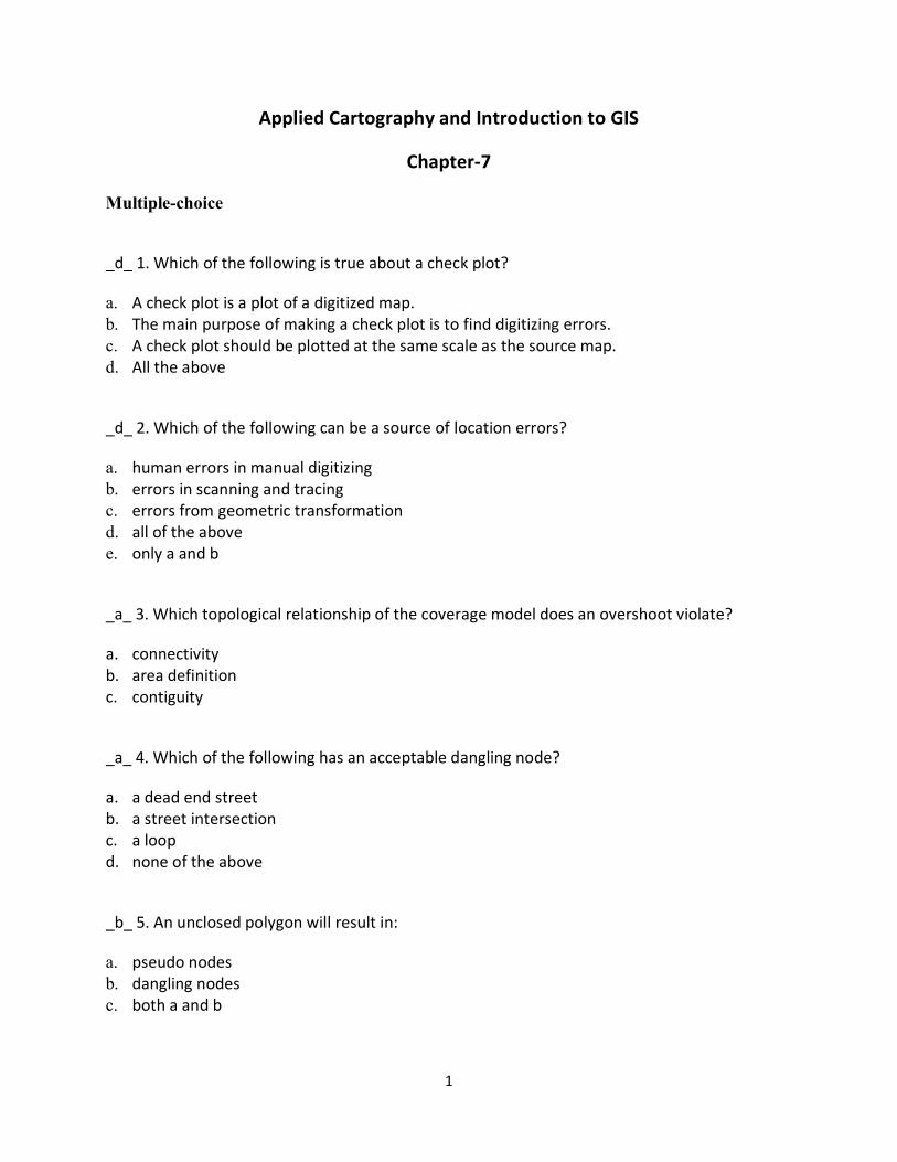
Applied Cartography and Introduction to GIS
Chapter-7
Multiple-choice
_d_ 1. Which of the following is true about a check plot?
a. A check plot is a plot of a digitized map. b. The main purpose of making a check plot is to find digitizing errors. c. A check plot should be plotted at the same scale as the source map. d. All the above
_d_ 2. Which of the following can be a source of location errors?
a. human errors in manual digitizing b. errors in scanning and tracing c. errors from geometric transformation d. all of the above e. only a and b
_a_ 3. Which topological relationship of the coverage model does an overshoot violate?
a. connectivity b. area definition c. contiguity
_a_ 4. Which of the following has an acceptable dangling node?
a. a dead end street b. a street intersection c. a loop d. none of the above
_b_ 5. An unclosed polygon will result in:
a. pseudo nodes b. dangling nodes c. both a and b
2
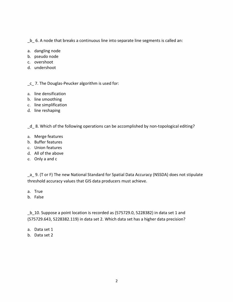
_b_ 6. A node that breaks a continuous line into separate line segments is called an:
a. dangling node b. pseudo node c. overshoot d. undershoot
_c_ 7. The Douglas-Peucker algorithm is used for:
a. line densification b. line smoothing c. line simplification d. line reshaping
_d_ 8. Which of the following operations can be accomplished by non-topological editing?
a. Merge features b. Buffer features c. Union features d. All of the above e. Only a and c
_a_ 9. (T or F) The new National Standard for Spatial Data Accuracy (NSSDA) does not stipulate threshold accuracy values that GIS data producers must achieve.
a. True b. False
_b_10. Suppose a point location is recorded as (575729.0, 5228382) in data set 1 and (575729.643, 5228382.119) in data set 2. Which data set has a higher data precision?
a. Data set 1 b. Data set 2

3
_a_11. (T or F) Topology rules in ArcGIS can only be applied to feature classes in a feature dataset.
a. True b. False
_a_12. (T or F) Line smoothing is the process of reshaping lines by using splines or some other mathematical functions.
a. True b. False
4
Applied Cartography and Introduction to GIS
Chapter-8
Multiple-choice
_b_ 1. Each row in an attribute table represents a _______ and each column represents a _______:
a. characteristic, feature b. feature, characteristic c. characteristic, characteristic d. feature, feature
_b_ 2. Data that can be differentiated by a ranking relationship are called:
a. nominal data b. ordinal data c. interval data d. ratio data
_b_ 3. Which of the following is not considered a data type?
a. date b. degree c. number d. text or character
_a_ 4. The simplest data relationship for GIS operations is the:
a. one-to-one relationship b. one-to-many relationship c. many-to-one relationship d. many-to-many relationship
5
_a_ 5. (T or F) The width used in a field definition should accommodate the largest number or the longest string in the data.
a. True b. False
_d_ 6. Which of the following is not true about a relational database?
a. A primary key and a foreign key are needed to relate two tables in the database. b. Attributes in the database can be numeric or character. c. The database is made of separate tables. d. None of the above.
_a_ 7. Data grouped into different categories are called:
a. nominal data b. ordinal data c. interval data d. ratio data
_d_ 8. Which of the following operations can create new attribute data from existing data?
a. data classification b. data query c. data computation d. only a and c e. only b and c
_a_ 9. Which of the following is a potential drawback of normalization?
a. slowing down of data access b. running out of primary and foreign keys c. missing tables d. none of the above
_a_10. (T or F) ArcGIS can import attribute data from dBASE and Excel files.
a. True b. False
6
_a_11. (T or F) ArcGIS can work with both internal and external databases.
a. True b. False
_c_12. In ArcGIS, a domain is considered to be a property of a:
a. feature class b. feature dataset c. geodatabase
_b_13. If you have 3 tables to be linked, how many relates do you need to establish?
a. 1 b. 2 c. 3 d. 4
_a_14. (T or F) In ArcGIS, one can add a field in either ArcCatalog or ArcMap.
a. True b. False
7
Applied Cartography and Introduction to GIS
Chapter-9
Multiple-choice
_b_ 1. Which of the following symbol type will you use for displaying rates of population change by county (or equivalent area unit) in your state?
a. single symbol b. graduated color c. unique value d. dot
_c_ 2. Which of the following is not considered a visual variable in symbolization?
a. shape b. size c. diagram d. pattern e. color
_a_ 3. Which color dimension is not suited for quantitative data?
a. hue b. value c. chroma
_b_ 4. Which of the following is an example of the ‘hue and value’ color scheme?
a. blues to reds dichromatic b. orange monochromatic c. yellow to green to dark blue
_b_ 5. Which of the following map types uses a specific symbol size for each value?
a. the graduated symbol map b. the proportional symbol map

8
_b_ 6. (T or F) A USGS quadrangle map is normally considered a thematic map.
a. True b. False
_d_ 7. Type size is measured in points, with ____ points to an inch:
a. 24 b. 36 c. 48 d. 72
_b_ 8. The general rule for labeling a line feature is to ____________:
a. spread the name over the extent of the feature. b. place the name in a block. c. Place the name along the curvy part of the feature.
_b_ 9. The principle of interposition in visual perception suggests that
a. An object with an incomplete outline appears at the same level as another. b. An object with an incomplete outline appears behind another. c. An object with an incomplete outline appears in front of another.
_d_10. Which of the following visual variables can be used to add contrast in map design?
a. color b. size c. texture d. all of the above
9
_c_11. Which color model is used for printing color maps?
a. RGB b. HSV c. CMYK d. none of the above
_d_12. Which of the following is considered a softcopy map?
a. a map to be used in a PowerPoint presentation b. a map to be posted on the Internet c. a printed map d. only a and b e. only b and c
_a_13. (T or F) One should not expect to see a perfect match between color symbols on a computer screen and a printed map.
a. True b. False
_b_14. Which labeling method lets you label all or selected features at once in ArcMap?
a. interactive labeling b. dynamic labeling
_c_15. You are asked to plot in a single layout separate maps showing the national parks in the U.S., U.K., and Sweden. How many data frames in ArcMap do you need to use for the layout?
a. 1 b. 2 c. 3 d. 4

10
_b_16. (T or F) Using the interposition principle, an object with an incomplete outline will appear above another object with a complete outline.
a. True b. False
11
Applied Cartography and Introduction to GIS
Chapter-10
Multiple-choice _c_ 1. How many variables can be displayed in a bubble plot?
a. 1 b. 2 c. 3 d. 4
_b_ 2. Which Boolean connector is the keyword used in the Intersect operation on sets in probability?
a. NOT b. AND c. OR
_b_ 3. Which of the following is not a Boolean connector?
a. AND b. AT LEAST c. OR d. XOR
_c_ 4. Which Boolean connector is the keyword used in the Union operation on sets in probability?
a. NOT b. AND c. OR
_d_ 5. Which of the following is true about relational database query? a. One can work with two or more tables. b. Relational database queries rely on keys that connect tables. c. One may query tables that are connected by either join or relate. d. All of the above. e. Only a and b.
12
_a_ 6. (T or F) ArcGIS Desktop allows users to query an external database. a. True b. False
_a_ 7. Which spatial relationship would one use to find banks within a county?
a. containment b. intersect c. proximity/adjacency
_b_ 8. Which spatial relationship would one use to find land parcels that are on an earthquake fault line? a. containment b. intersect c. proximity/adjacency
_d_ 9. Which of the following graphic objects can be used for selecting map features?
a. a circle b. a rectangle c. an irregular polygon d. all of the above e. a and b only
_c_10. Which statement is true when one wants to perform queries using both spatial and attribute data? a. One must perform attribute data query first. b. One must perform spatial data query first. c. One can perform query first with either spatial data or attribute data. d. None of the above.
_c_11. Using SQL, one will set up a query expression following the keyword_____:
a. Select b. From c. Where
13
_a_12. Which of the following statements is true about ArcGIS Desktop?
a. Maps, tables, and charts can be dynamically linked. b. Only maps and tables can be dynamically linked. c. Only tables and charts can be dynamically linked. d. None of the above.
_b_13. Selection by Location in ArcMap is designed for: a. attribute data query b. spatial data query c. both attribute data query and spatial data query
_c_14. Which of the following statements is true about raster data query?
a. One can query a raster by cell value. b. One can query a raster by using points, circles, or polygons. c. One can query two or more rasters at a time. d. All of the above. e. Only a and b.
_a_15. (T or F) Animations can be made in ArcGIS Desktop.
a. True
b. False

14
Applied Cartography and Introduction to GIS
Chapter-11
Multiple-choice
_d_ 1. Which of the following is true about buffering?
a. You can either dissolve the buffer zones or keep the buffer zones separate. b. You have the options of creating a single ring or multiple rings. c. You can buffer with different buffer distances. d. All of the above. e. Only a and b
_a_ 2. Which overlay method combines the area extents from both input layers?
a. Union b. Intersect c. Identity d. Symmetrical difference
_b_ 3. Which overlay method uses the Boolean operation of AND?
a. Union b. Intersect c. Identity d. Symmetrical difference
_c_ 4. Buffering a point creates a buffer zone that is a ____:
a. point b. line c. circle d. square
15
_d_ 5. Which overlay method uses the Boolean operation of XOR?
a. Union b. Intersect c. Identity d. Symmetrical difference
_c_ 6. Error propagation in overlay operations can be caused by:
a. digitizing errors b. inaccuracies of attribute data c. both a and b
_a_ 7. Which operation can remove boundaries between polygons that have the same value of a select attribute?
a. Dissolve b. Merge c. Clip
_b_ 8. Which overlay method preserves only those features that fall within the area extent common to the input and overlay layers?
a. Union b. Intersect c. Identity d. Symmetrical difference
_a_ 9. (T or F) You must use a polygon layer to define the area for clipping in a Clip operation.
a. True b. False
_b_10. Which of the following conditions is required by Union?
a. The input layer can be a line or polygon layer but the overlay layer must be a polygon layer. b. Both the input and overlay layers must be polygon layers. c. The input layer must be a polygon layer but the overlay layer can be a line or polygon layer. d. None of the above.
16
_c_11. You have downloaded a shapefile from a website that shows toxic waste sites in your state. Which operation will you use to get a map showing toxic waste sites within a 10-mile buffer zone map that you have made around your home?
a. Erase b. Dissolve c. Clip d. Eliminate
_d_12. You have a land use map that shows land use classes of urban, agricultural, commercial, and so on. Which operation will you use to get a new map that only shows agricultural land use?
a. Erase b. Eliminate c. Clip d. Select
_a_13. (T or F) ArcGIS does not automatically update the area and perimeter values of an overlay output if shapefiles are used as the input layers.
a. True b. False
_b_14. Which of the following analyses is also called multi-distance spatial clustering analysis?
a. nearest neighbor analysis b. Ripley’s K-Function c. Moran’s I d. G-Statistic
_d_15. Which of the following statements is true about vector data analysis?
a. Vector data analysis uses points, lines, and polygons as inputs. b. The accuracy of vector data analysis depends on the accuracy of inputs in terms of their
location and shape. c. Vector data analysis may apply to all, or selected, features in an input layer. d. All of the above e. a and b only
17
Applied Cartography and Introduction to GIS
Chapter-12
Multiple-choice
_b_ 1. (T or F) A local operation is limited to only two input rasters.
a. True b. False
_d_ 2. Which of the following mathematical functions can be used for local operations? a. arithmetic b. logarithmic c. trigonometric d. all of the above e. only a and b _d_ 3. Which of the following can be used to specify the area extent for analysis? a. a specified raster b. an area defined by its minimum and maximum values in x- and y-coordinates c. an analysis mask d. all of the above e. only a and c _c_ 4. Which local operation can assign a unique output value to each unique combination of cell values from multiple rasters? a. Add b. Merge c. Combine d. Reclassify _b_ 5. (T or F) The cell value of ‘no data’ is treated as zero in raster data operations.
a. True b. False
_b_ 6. (T or F) We must convert all input rasters to the same cell size before using them in ArcGIS for a raster data operation.
a. True b. False
18
_d_ 7. Which of the following can be used as a neighborhood in raster data operation?
a. A 3x3 rectangle b. A 5x5 rectangle c. A circle d. All of the above e. Only a and b
_a_ 8. (T or F) A zone in raster data operation may consist of contiguous cells or separate regions of cells.
a. True b. False
_c_ 9. Which of the following statistics is appropriate for use with categorical data?
a. Mean b. Median c. Majority d. Sum
_a_10. (T or F) A neighborhood operation on a raster requires the focus cell to move from one cell to another until all cells are visited. a. True b. False _e_11. Which of the following statistics cannot be used in a neighborhood operation? a. maximum b. mean c. majority d. minority e. none of the above
_a_12. (T or F) A zonal operation on a single input raster produces measures of the zonal geometry. a. True b. False
19
_d_13. Which of the following statements is not true about a block operation?
a. A block operation is similar to a neighborhood operation. b. A block operation assigns the calculated value to all cells in a block. c. A block operation does not move from cell to cell, but from block to block. d. None of the above _b_14. The output from a 5x5 neighborhood operation will be _________ the output from a 3x3 neighborhood operation: a. the same as b. more generalized than c. less generalized than
_a_15. (T or F) An analysis mask limits analysis to cells that do not carry the cell value of ‘no data.’
a. True b. False
_d_16. Which of the following can be used to extract data from an existing raster? a. a polygon shapefile b. a circle c. a query expression d. all of the above e. b and c only
20
Applied Cartography and Introduction to GIS
Chapter-13
Multiple-choice
_a_ 1. Which of the following NED DEMs has the highest vertical accuracy?
a. NED 1 Arc Second b. NED 1/3 Arc Second c. NED 1/9 Arc Second
_a_ 2. LIDAR data can provide DEMs with a spatial resolution of
a. finer than 2 meters b. 5 to 10 meters c. 10 to 20 meters
_c_ 3. Which of the following statements is true about DEMs and TINs?
a. One can only convert a DEM into a TIN. b. One can only convert a TIN into a DEM. c. One can convert a DEM into a TIN, or a TIN into a DEM. d. None of the above.
_a_ 4. (T or F) ArcGIS can derive a slope layer in either percent slope or degree slope.
a. True b. False _b_ 5. Deriving slope and aspect from an elevation raster is a ______ operation:
a. local b. neighborhood c. zonal d. global
21
_d_ 6. The accuracy of slope measures from a GIS can be influenced by a. the computing algorithm b. the resolution of DEM c. local topography d. all of the above e. only a and b
_d_ 7. Aspect readings can range from:
a. 0 to 100 degrees b. 0 to 90 degrees c. 0 to 180 degrees d. 0 to 360 degrees
_b_ 8. (T or F) Using the same input data, one can always derive the same slope layer from different GIS packages.
a. True b. False
_d_ 9. The local illumination condition in a hillshade view can be influenced by a. local slope b. local aspect c. sun’s angle d. all of the above _b_10. Which of the following parameters represents the direction from the observer to the surface in a 3-D view? a. viewing angle b. viewing azimuth c. viewing distance d. Z-scale _b_11. A hillshade map would look _____ if the sun’s angle were higher: a. darker b. lighter c. the same
22
_a_12. Which of the following parameters represents the angle measured from the horizon to the altitude of the observer in a 3-D view?
a. viewing angle b. viewing azimuth c. viewing distance d. none of the above
_a_13. Z-scale in a 3-D view represents the ratio of:
a. the vertical scale / the horizontal scale b. the horizontal scale / the vertical scale
_b_14. A positive surface curvature value means an upwardly _____ surface and a negative curvature value means an upwardly ______ surface:
a. concave, convex b. convex, concave
_b_15. To create a TIN in ArcGIS, one must use the extension of: a. Spatial Analyst b. 3D Analyst c. 3D Scene d. Geostatistical Analyst
_a_16. Which of the following statements is true about DEM and TIN?
a. A DEM can be converted into a TIN, and a TIN can be converted into a DEM. b. A DEM can be converted into a TIN, but a TIN cannot be converted into a DEM. c. A TIN can be converted into a DEM, but a DEM cannot be converted into a TIN.
23
Applied Cartography and Introduction to GIS
Chapter-14
Multiple-choice
_a_ 1. (T or F) The basis for viewshed analysis is called the line of sight operation: a. True b. False _c_ 2. If you have 2 observation points for a viewshed analysis, the output raster from ArcGIS will have ____different cell values: a. 1 b. 2 c. 3 d. 4 _a_ 3. (T or F) A viewing azimuth of 180°will cover a larger viewing area than a viewing azimuth of 45°. a. True b. False _c_ 4. Viewshed analysis can be performed using: a. an elevation raster b. a TIN c. both a and b _a_ 5. (T or F) In ArcGIS, the parameters for viewshed analysis such as viewing azimuth are set up as attributes in the viewpoint data set. a. True b. False _c_ 6. A filled DEM means that: a. An elevation value has been filled for each cell in the raster. b. Cells with ‘no data’ have been removed from the raster. c. Sinks have been removed from the raster. d. None of the above. _a_ 7. (T or F) The D8 method for deriving flow directions is most effective in steep terrain with well-defined channels. a. True b. False
24
_b_ 8. A higher threshold value applied to a flow accumulation raster typically result in a ______ stream network: a. denser b. less dense _b_ 9. A stream link raster has a unique ID value for: a. each stream junction b. each stream segment between two junctions c. each named stream d. each stream outlet _d_10. Which of the following can affect the result of watershed analysis? a. DEM resolution b. Flow direction method c. Flow accumulation threshold d. all of the above e. a and c only _d_11. Which of the following statements is true about watershed analysis? a. Watershed analysis can take place at different spatial scales. b. Delineation of watersheds can be area-based or point-based. c. Watersheds may be truncated along the study area boundary. d. All of the above. e. Only a and c. _b_12. (T or F) ArcGIS offers different algorithms for calculating flow direction including D8 and D∞. a. True b. False