Embed Size (px)
DESCRIPTION
Applied GIS, Karachi, Malir, Urban landuse, Revenue generation
Citation preview
The Research Journal of Sciences and Technology 2(1&2):1-16 © 2011, ISSN 2226-0110 The official publication of Faculty of Sciences
FEDERAL URDU UNIVERSITY OF ARTS, SCIENCES & TECHNOLOGY
Corresponding Author: Prof. Dr. Farkhunda Burke (email: [email protected]) 1
APPLICATION OF GIS ON URBAN LAND USE PLANNING AND
REVENUE GENERATION
Farkhunda Burke,1 Syed Nawaz ul Huda,
2 Muhammad Azam,
2 Muhammad Miandad
1
1. Department of Geography, University of Karachi, Karachi, 75270
2. Department of Geography, Federal Urdu University of Arts, Sciences & Technology Karachi,
Abstract The lacune of GIS technology in Pakistan’s planning is chiefly due to lack of proper maps and micro level
landuse information. In the case of Karachi, inaccurate targeting of planning and implementation has been
responsible for immense wastage of valuable funds. Development of urban landuse database at the grass roots
level is therefore, an urgent need. Targetting this need, present study aims at providing a database for the mega
polis of Karachi. GIS has been identified as an effective tool for preparing landuse data sets for regional
planning and micro level planning. In addition to this technology, the study is based on fieldwork, primary and
secondary data use, including RS methods for extraction, analysis and display of facilities at Union Council
level in Karachi, the future World City.
Article Received: 01-03-11, Accepted: 28-07-11
Key words: Applied GIS, Karachi, Malir, Urban landuse, Revenue generation
1. INTRODUCTION
The urbanization process in Pakistan and its pace of growth has accelerated over the past fifty
years. Karachi is now a mega polis with a population of 15.1 million along with other cities
like Bombay, Calcutta, Jakarta, Nairobi, Manila, Lagos and Cairo. Intervention by planners
and administrators requires spatial and socio-economic data collection and analysis at
different levels of utility services especially in view of the unplanned urban physical
environment. The process of urban development is guided and coordinated by the
development plan of the City. Karachi has witnessed several Master Plans, the last having
been formulated in 2008 (MPGO-CDGK, 2008), but most of these plans were vitiated at
various stages of their implementation, both in qualitative and quantitative terms. In most
sectors of development, the spirit of the proposal is not translated adequately into the
envisaged framework, resulting in differentiated, disjointed and undesirable urban growth.
Failure to meet the demands in a guided manner, illegal occupation of sites and services, land
use transformation, encroachment and unauthorized construction take place, thus culminating
in the degradation of the urban environment. It is here that the issue of urban assessment
assumes prime importance.
Urban activity is a function of land use and there is a close interaction of cause and effect
relationship between land use and services. Multidisciplinary and integrative tools are of
special importance when problems are multifaceted as is true for the management of third
world cities. RS and GIS are technologies that can handle information on both location and
its characteristics within a single system and is being increasingly recognized as a powerful
modeling tool in a variety of fields (Qiong, et al., 2006; Xia Li, and Yeh, 2004; Sui, 1998;
Yeh, 1999). GIS has great potential to easily and accurately map and model urban
components and help in systematization and streamlining of urban policies and subsequent
development. Lack of access to pertinent data along with a shortage of skilled personnel is a
Application of GIS on urban land use planning and revenue generation
2
great hurdle in the solution of urban problems in the developing world. Along with this, there
are impediments of preferred solution.
GIS technology is most commonly used for comprehensive planning, zoning, land use
inventories, site suitability assessments, and socio-demographic analysis, and is generally
used for mapping purposes (Thomas, 2002; Warnecke, et al. 1998). The value of maps in
understanding and communicating planning issues is well recognized and appreciated.
GIS database development must be based on a clear understanding of planning problems,
process, and context (Clercq, 1990). Furthermore, since planning databases are usually
derived by compiling data from multiple sources and of varying qualities and scales, it is
necessary to apply the rules of interoperability and integration (Devogele, et al., 1998). In the
positivistic vein, GIS databases are most frequently used for performing planning-related
analysis and scientific inquiries (Wellar, et al. 1994). Webster (1993; 1994) match the
scientific input required to the various stages of the planning process: problem identification
requires description and prediction; goal setting, plan generation, evaluation of alternatives,
and choice of solution requires prescription; implementation requires description, prediction,
and prescription; and monitoring requires description and prediction.
Due to lack of proper maps and information of land use at the micro level in Karachi,
planning and implementation by the local government is not accurately targeted, causing
wastage of valuable funds. Development of urban land use database at the grass roots level is
therefore, urgently needed. The study aims at providing a database for this purpose, for the
mega polis of Karachi, starting from the grass roots level, and GIS has been identified as an
effective tool in preparing land use data sets required for urban and regional planning and
micro level planning. GIS can also be used as a graphical display tool for demonstrating the
variations of existing conditions, for proper policy formulation, prior to planning allocations,
an essential prerequisite for planners and administrators.
The present study highlights the potentials of spatial information technology beginning with
GIS for solving planning and administrative problems. A number of studies both in developed
and in developing countries has been made on the geo-information use in government
(Georgiadou and Stoter 2010). Application of GIS for urban analysis and planning to assess
the amenity patterns; parcel suitability for potential park locations; municipal waste
generation and collection; GIS and Geo-statistics for modeling; 3D city models for urban
GIS; the delivery of humanitarian shelter in urban areas, etc. Micro level studies have been
made in the USA for the analysis of urban schoolyard land cover (Schulman and Peters,
2007). GIS is an essential technology component for future management and decision-making
(Ahmed, 2008). In developing countries, lack of spatial database, not only effects balanced
planning but also conceals the revenue resources, while GIS can provide help in resolving
these issues both at macro as well as micro levels.
2. STUDY AREA
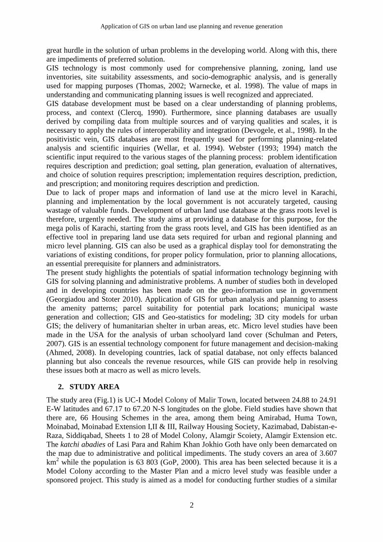
The study area (Fig.1) is UC-I Model Colony of Malir Town, located between 24.88 to 24.91
E-W latitudes and 67.17 to 67.20 N-S longitudes on the globe. Field studies have shown that
there are, 66 Housing Schemes in the area, among them being Amirabad, Huma Town,
Moinabad, Moinabad Extension I,II & III, Railway Housing Society, Kazimabad, Dabistan-e-
Raza, Siddiqabad, Sheets 1 to 28 of Model Colony, Alamgir Scoiety, Alamgir Extension etc.
The katchi abadies of Lasi Para and Rahim Khan Jokhio Goth have only been demarcated on
the map due to administrative and political impediments. The study covers an area of 3.607
km2 while the population is 63 803 (GoP, 2000). This area has been selected because it is a
Model Colony according to the Master Plan and a micro level study was feasible under a
sponsored project. This study is aimed as a model for conducting further studies of a similar
Burke, et al., 2011
3
nature, in the better interest of planning and management of the infrastructure and supra-
structure of Karachi, destined to become a World City.
Malir Town
Malir Town Union Councils
Karachi Towns
0 40
kilometres
N
S
EW
0 1 2
kilometer
Union Council
Model Colony
Fig.1: Study Area
3. MATERIAL AND METHOD
3.1 Data Source
Three major sources have been used for primary data collection i.e., remote sensing, layout
maps and ground truthing. Secondary data i.e. population and other data have been collected
form Census Department. High resolution satellite image (Google Earth 2010) has been used
to create base map of the study area which also provides the basis for digitization of land
marks, classification of existing data, etc. Collection of layout maps has been unsatisfactory
due to mismanagement of concerned authorities, although rough master maps of the area
were available but change of plot size and encroachments has hindered GIS database
development. Some of the layout maps available are of the newly created housing societies,
which are few in number. Questionnaire survey and ground truthing was conducted several
times during different parts of the year i.e. from June 2009 till April 2010, and on different
days of the week, at varying daytime and evening hours in order to get wider temporal
coverage.
3.2 Database Development
One of the most difficult challenges in regional planning is data management and map
product creation. Providing needed geospatial data (i.e., map products) to decision makers,
planners, engineers, and analysts is a difficult task that is further complicated by the use of
large geospatial image data sets that are needed for the products. Database development,
aided by GIS and RS facilitate in quantifying, monitoring, modeling and subsequently
predicting in the realm of regional planning (Sudhira, 2004; Civco et al., 2002; ICIMOD,
1999;). These data sets usually comprise large data files that are difficult to transfer, hence,
require significant storage resources, and is a time-consuming and complicated process. A
well-defined data model is one of the basic pillars on which a database depends. The lack of
sufficient thought in the planning of the model would have led to the incoming data being put
Application of GIS on urban land use planning and revenue generation
4
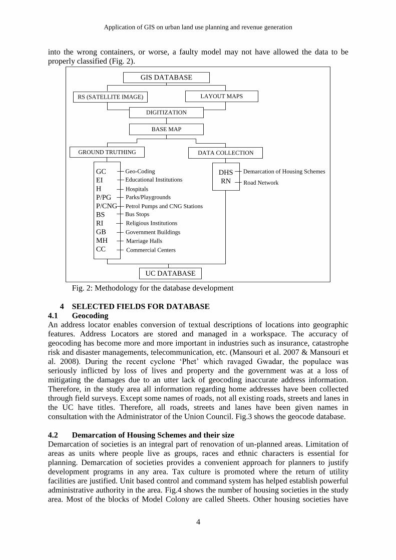
into the wrong containers, or worse, a faulty model may not have allowed the data to be
properly classified (Fig. 2).
GIS DATABASE
RS (SATELLITE IMAGE) LAYOUT MAPS
DIGITIZATION
BASE MAP
GROUND TRUTHING DATA COLLECTION
GC
EI
H
P/PG
P/CNG
BS
RI
GB
MH
CC
DHS
RN
UC DATABASE
Geo-Coding
Educational Institutions
Hospitals
Parks/Playgrounds
Petrol Pumps and CNG Stations
Bus Stops
Religious Institutions
Government Buildings
Marriage Halls
Commercial Centers
Demarcation of Housing Schemes
Road Network
Fig. 2: Methodology for the database development
4 SELECTED FIELDS FOR DATABASE
4.1 Geocoding
An address locator enables conversion of textual descriptions of locations into geographic
features. Address Locators are stored and managed in a workspace. The accuracy of
geocoding has become more and more important in industries such as insurance, catastrophe
risk and disaster managements, telecommunication, etc. (Mansouri et al. 2007 & Mansouri et
al. 2008). During the recent cyclone ‘Phet’ which ravaged Gwadar, the populace was
seriously inflicted by loss of lives and property and the government was at a loss of
mitigating the damages due to an utter lack of geocoding inaccurate address information.
Therefore, in the study area all information regarding home addresses have been collected
through field surveys. Except some names of roads, not all existing roads, streets and lanes in
the UC have titles. Therefore, all roads, streets and lanes have been given names in
consultation with the Administrator of the Union Council. Fig.3 shows the geocode database.
4.2 Demarcation of Housing Schemes and their size
Demarcation of societies is an integral part of renovation of un-planned areas. Limitation of
areas as units where people live as groups, races and ethnic characters is essential for
planning. Demarcation of societies provides a convenient approach for planners to justify
development programs in any area. Tax culture is promoted where the return of utility
facilities are justified. Unit based control and command system has helped establish powerful
administrative authority in the area. Fig.4 shows the number of housing societies in the study
area. Most of the blocks of Model Colony are called Sheets. Other housing societies have
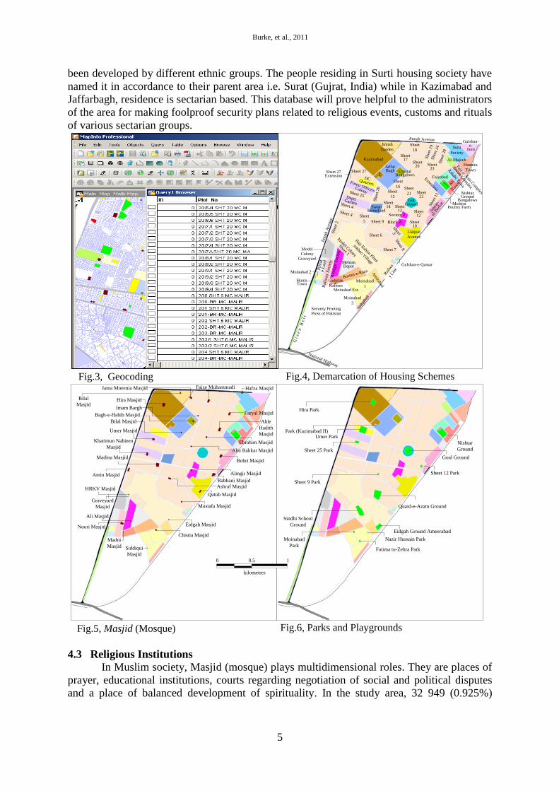
Burke, et al., 2011
5
been developed by different ethnic groups. The people residing in Surti housing society have
named it in accordance to their parent area i.e. Surat (Gujrat, India) while in Kazimabad and
Jaffarbagh, residence is sectarian based. This database will prove helpful to the administrators
of the area for making foolproof security plans related to religious events, customs and rituals
of various sectarian groups.
National Highway
Rai
lwa
y Lin
e
Jinnah
Aven
ue
Jinnah Avenue
Moinabad
3
Sidq
abad
Moinabad Ext.
Moinabad
1
Bostan-e-Raza
Gulistan-e-
Kaleem
Huma Town
Moinabad 2
Rai
lway
Soci
ety
Ala
mgir
Soci
ety
Am
irabad
Haji R
ahim K
han
Jokheo Village
Model C
olony
Sheet 1
Shee
t 2
Sheet 6
Sheet 7
Gulshan-e-Qamar
Sheet 8
Liaquat
Avenue
Sheet 10
Block A
Society 2Sheet
12
Sheet 13
Sheet 14
Sheet 9
Sheet
5
Sheet 4
Sheet 25
Sweet Homeland
Shee
t 26
Sheet
15
Sheet
21
Sheet
16
Crystal Bungalows
Kazimabad
2
Jinnah
GardenSheet
18
Shee
t 19
Shee
t 24
Shee
t 28
Surti
Society
Gulshan-e-
Jami
Humera
Town
Jawan C
omplex
Faiz-e-Aam
Com
plex
Ashabi T
ownA
li Tow
n
Nishtar Ground
BungalowsModern
Poultry Farm
Jann
at-
ul-B
arka
t
She
et 1
1Sheet 22
Sheet 23
Sheet 20
Sheet 17
Sheet 27Sheet 27 Extension
DC QuartersForest Officers Colony
Deptt. Garden
Jaffar Bagh
Extension
Faizabad
Al-Mujeeb
Gol Ground
Sheet
3
Mehran Depot
Pri
vat
e L
and
Model Colony
Graveyard
Security Printing Press of Pakistan
G r
e e
n B
e l t
Sheet 4
Fatima tu-Zehra Park
Nazir Hussain ParkMoinabad
Park
Sindhi School
Ground
Eidgah Ground Ameerabad
Quaid-e-Azam Ground
Sheet 9 Park
Sheet 12 Park
Nishtar
Ground
Goal Ground
Sheet 25 Park
Umer ParkPark (Kazimabad II)
Hira Park
Fig.3, Geocoding Fig.4, Demarcation of Housing Schemes
Fig.6, Parks and Playgrounds
Siddiqui
Masjid
Madni
Masjid
Noori Masjid
Chistia Masjid
Eidgah Masjid
Mustafa Masjid
Qutub Masjid
Rabbani Masjid
Almgir Masjid
Bohri Masjid
Ebrahim Masjid
Ahle
Hadith
Masjid
Faryal Masjid
Ali Masjid
Graveyard
Masjid
HRKV Masjid
Amin Masjid
Ashraf Masjid
Madina Masjid
Khatimun Nabieen
Masjid
Umer Masjid
Abu Bakkar Masjid
Bilal Masjid
Bagh-e-Habib Masjid
Imam Bargh
Hira Masjid Bilal
Masjid
Jama Moeenia Masjid Faize Muhammadi Hafza Masjid
Fig.5, Masjid (Mosque)
0 0.5 1
kilometres
4.3 Religious Institutions
In Muslim society, Masjid (mosque) plays multidimensional roles. They are places of
prayer, educational institutions, courts regarding negotiation of social and political disputes
and a place of balanced development of spirituality. In the study area, 32 949 (0.925%)
Application of GIS on urban land use planning and revenue generation
6
square yards has been reserved for religious institutions. Fig. 5 shows presence of Masjid in
the study area.
4.4 Parks and Playgrounds
Landscape beauty has been an attraction for human beings since he was in paradise.
Subsequent to industrialization, residents were clustered around industrial estates, thus,
crteating an excessive population pressence in these income-generating regions. This undue
agglomeration of urban population led to the development of model settlements where the
residental areas were planned with allocation of areas for community and recreational
facilities etc (Floyd, et al., 2009). In the present era, industrialization has been identified as
one of the major causes of environmental pollution. Therefore, open green spaces must be
maintained in order to mitigate environmental pollution as people of all ages visit parks at
different hours of the day and evenings with different objectives, primarily health objective
(Burke, et al. 2007). The greenery of parks and playgrounds not only reduce environmental
pollution but are also soothing to the human eyes and are meant for refreshment must be
maintained in the open green spaces. Greenery in the form of grasses, shrubs, bushes,
creepers, hedges, flower beds, trees etc (Burke, et al., 2009). Both quality and quantity of
parks and playgrounds have great significance in determining the spatial variation of amenity
values in the housing market (Cho, et al., 2008). In the present study, area of parks and
playgrounds has been measured 72 043 square yards (2.02%) out of 3,563,000 square yards
of study area. Fig. 6 shows the location of Parks and Playgrounds.
4.5 Educational Institutions
It is generally accepted that improving the performance of education systems is
necessary for socio-economic development (Grignon, 2008; Ayan and Taşpinar, 2009)
economic competitiveness, and equality among different groups in societies, better
functioning of the governmental institutions, democracy and human rights. Schools are the
base of educational development. Improper planning of settlements focusing only on housing
needs regardless of basic rights such as school, force people to travel long distances in order
to avail proper education facilities for their children. Ideally, there should be a Pre-
primary/Nursery school for every 200, a Primary school for every 5 000 and a Secondary
school for a local population of about 7 500 (EBGGH, 2010).
Estimated school going age population (age 4 to 16) of the UC are 32 560 while, 42 schools
facilitate their education. Development of database will facilitate the UC administration to
tackle the problems of the education system and to plan beneficial system of educational
structure for their population. Most of the schools are run by private administration while
government schools are few in number.
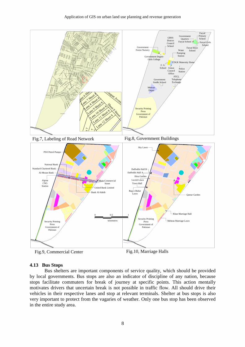
4.6 Road Network
The success and progress of any area is dependent on the availability of physical
infrastructure for distributing resources and essential services to the public. The quality and
efficiency of this infrastructure affects quality of life, the health of the social system, and the
continuity of economic and business activities (Zigelbauer, et al., 2005; Santosa and
Joewono, 2005; Langdon, 2003; Wong, 2001). The economic strength of local government is
reflected in its infrastructural asset (Bennett, et al., 2004; Rodríguez-Pose, et al., 2001). The
history of economic and social system walks parallel with infrastructure development; good
infrastructure facilitates a higher quality of life (Hudson, et.al., 1997) and demands on
infrastructure and related services increase as people expect a higher quality of life and public
services. In the study area, total road network consists of 93km in length with 3.26km width.
Fig. 7 depicts the road network in the study area.
Burke, et al., 2011
7
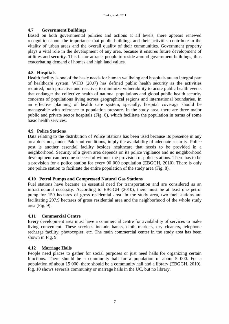
4.7 Government Buildings Based on both governmental policies and actions at all levels, there appears renewed
recognition about the importance that public buildings and their activities contribute to the
vitality of urban areas and the overall quality of their communities. Government property
plays a vital role in the development of any area, because it ensures future development of
utilities and security. This factor attracts people to reside around government buildings, thus
exacerbating demand of homes and high land values.
4.8 Hospitals
Health facility is one of the basic needs for human wellbeing and hospitals are an integral part
of healthcare system. WHO (2007) has defined public health security as the activities
required, both proactive and reactive, to minimize vulnerability to acute public health events
that endanger the collective health of national populations and global public health security
concerns of populations living across geographical regions and international boundaries. In
an effective planning of health care system, specially, hospital coverage should be
manageable with reference to population pressure. In the study area, there are three major
public and private sector hospitals (Fig. 8), which facilitate the population in terms of some
basic health services.
4.9 Police Stations
Data relating to the distribution of Police Stations has been used because its presence in any
area does not, under Pakistani conditions, imply the availability of adequate security. Police
post is another essential facility besides healthcare that needs to be provided in a
neighborhood. Security of a given area depends on its police vigilance and no neighborhood
development can become successful without the provision of police stations. There has to be
a provision for a police station for every 90 000 population (EBGGH, 2010). There is only
one police station to facilitate the entire population of the study area (Fig. 8).
4.10 Petrol Pumps and Compressed Natural Gas Stations
Fuel stations have became an essential need for transportation and are considered as an
infrastructural necessity. According to EBGGH (2010), there must be at least one petrol
pump for 150 hectares of gross residential area. In the study area, two fuel stations are
facilitating 297.9 hectares of gross residential area and the neighborhood of the whole study
area (Fig. 9).
4.11 Commercial Centre Every development area must have a commercial centre for availability of services to make
living convenient. These services include banks, cloth markets, dry cleaners, telephone
recharge facility, photocopier, etc. The main commercial center in the study area has been
shown in Fig. 9.
4.12 Marriage Halls
People need places to gather for social purposes or just need halls for organizing certain
functions. There should be a community hall for a population of about 5 000. For a
population of about 15 000, there should be a community hall and a library (EBGGH, 2010),
Fig. 10 shows severals community or marrage halls in the UC, but no library.
Application of GIS on urban land use planning and revenue generation
8
Security Printing
Press
Government of
Pakistan
PTCL
Telephone
ExchangeGovernment
Sindhi School
Mehran
Depot
Police
Station
Union
Council
Office
F. G.
School
CDGK Maternity Home
Water
Pumping
Station
Government
Forest Nursery
Government Degree
Girls College
GBSS
District
Council
School
Faryal Girls
School
Faryal Boys
School
Faryal
Primary
SchoolGovernment
Quarters
Faryal School
Sky Lawn
Mehran Marriage Lawn
Khan Marriage Hall
Bag-o-Bahar
Lawn
Town Hall
Lavish Lawn
Daffodils Hall A
Daffodils Hall B
Hina Garden
Qamar Garden
Fig.7, Labeling of Road Network Fig.8, Government Buildings
0 0.5 1
kilometres
Al-Mezan Bank
Standard Chartered Bank
National Bank
Bank Al-Habib
United Bank Limited
Alpine
CNG
Station
Main Commercial
Street
Fig.9, Commercial Center Fig.10, Marriage Halls
PSO Petrol Pumps
Security Printing
Press
Government of
Pakistan
Security Printing
Press
Government of
Pakistan
Liaquat Ali Khan Road
Cantt. Road (One Way)
Perposed Parking
Malir Halt Bypass
Perposed Hospital Road, Rahim Khan Village
Main
St.
Goal
Gro
un
d
Lan
e 4
Sh
eet
22
Lan
e 1 S
hee
t 22
Lan
e 4
Sh
eet
21
Lan
e 12 S
hee
t 23
Faryal School Road
Moinabad Avenue
Chistia Masjid Street
Lane 1 Moinabad ILane 2 Moinabad I
Lane 3 Moinabad ILane 4 M
oinabad I
Lane 10 Moinabad III
Lan
e 1 S
hee
t 27th
Lan
e 2 S
hee
t 27th
Lan
e 3 S
hee
t 27th
Lan
e 4 S
hee
t 27th
Lan
e 5 S
hee
t 27th
Lan
e 6 S
hee
t 27th
Lan
e 7 S
hee
t 27th
Lan
e 8 S
hee
t 27th
Lan
e 9 S
hee
t 27th
Lan
e 10 S
hee
t 27th
Lan
e 11 S
hee
t 27th
Lan
e 12 S
hee
t 27th
Coll
ege
Str
eet
DC Quarters St.
Lan
e 1 S
hee
t 27th
Ext.
Lan
e 3 S
hee
t 27th
Ext.
Lan
e 4 S
hee
t 27th
Ext.
Lane 1 Sheet 25Lane 2 Sheet 25Lane 3 Sheet 25
Str
eet
2 S
hee
t 25
Str
eet
3 S
hee
t 25
Str
eet
4 S
hee
t 25
Str
eet
1 S
hee
t 25
Lan
e 1
Kaz
imab
adL
an
e 2 K
azi
mab
ad
Lan
e 3 K
azi
mab
ad
Lan
e 5 K
azi
mab
ad
Lan
e 6
Kaz
imab
ad
Lan
e 7
Kaz
imab
ad
Lan
e 9
Kaz
imab
ad
Lan
e 8
Kaz
imab
ad
Lan
e 11
Kaz
imab
ad
Lan
e 10
Kaz
imab
ad
Lan
e 17
Kaz
imab
ad
Lan
e 18
Kaz
imab
ad
Lane 19 K
azim
abad
Lan
e 1
Jaffar
bagh
Link Street Jaffarbagh &
Sheet 17
Lane 1 C
rystal Bunglow
s
Lane 2 C
rystal Bunglow
s
Lane 6 C
rystal Bunglow
s
Lane 8 C
rystal Bunglow
s
Lan
e 2
Jaffar
bagh
Lan
e 3
Jaffar
bagh
Lan
e 8
Jaffar
bagh
Bila
l Mas
jid S
tree
t Jaf
farb
aghL
ink Street Jaffarbagh
Lan
e 1 S
hee
t 17
Lan
e 2 S
hee
t 17
Lane 8 Sheet 25
Lane 9 Sheet 25
Lane 10 Sheet 25
Lan
e 1 S
hee
t 18
Lan
e 2 S
hee
t 18
Lan
e 3 S
hee
t 18
Lan
e 4 S
hee
t 18
Lan
e 5 S
hee
t 18
Lan
e 6 S
hee
t 18
Lan
e 2 S
hee
t 19
Cantt. Wall Street
Lan
e 1 S
hee
t 24
Lan
e 2 S
hee
t 24
Lan
e 3 S
hee
t 24
Lin
k L
an
e S
hee
t 24 &
28
Lane 1 G
ulshan -e
- Jam
i
Lane 3 G
ulshan -e
- Jam
i
Lan
e 4
Guls
han -e
- Jam
i
Lan
e 5
Guls
han -e
- Jam
i
Lan
e 6
Guls
han -e
- Jam
i
Street 2
Moin
ab
ad
Ext.
Street 3
Moin
ab
ad
III
Street 4
Moin
ab
ad
III
Central Street Bostan-e-Raza
Central Street Gulshan-e-KaleemRashid Latif St
Lan
e 10 Bostan
-e-Raza
Huma Town St.
Lan
e 1R
ail
way S
oci
ety
Model Graveyard St.
Lan
e 2 R
ail
way S
oci
ety
Lan
e R
ail
way F
lats
Lan
e 3 R
ail
way S
oci
ety
Lan
e 1A
lam
gir
Soce
ity
Lan
e 4 A
lam
gir
Soce
ity
Lan
e 5 A
lam
gir
Soce
ity
Gra
vey
ard
Wall
Lan
e Q
au
id-e
-Aza
m G
rou
nd
Lan
e 1 S
hee
t 7
Lan
e 2 S
hee
t 7
Lan
e 3 S
hee
t 7
Lan
e 5 S
hee
t 7
Lan
e 6 S
hee
t 7
Lan
e 7 S
hee
t 7
Lan
e 8 S
hee
t 7
Lan
e 9 S
hee
t 7
Central St. Sheet 6
Lan
e 8 S
hee
t 6
Lan
e 9 S
hee
t 6
Lan
e 11 S
hee
t 6
Lan
e 12 S
hee
t 6
Lan
e 15 S
hee
t 6
Lasi P
ara
St.
Mai
n St
.1 R
ahim
Kha
n V
illag
e
Sindhi S
choo
l St.
Rah
im K
han V
illag
e
Mai
n St.3
Rah
im K
han V
illag
e
Cen
tral
St.
Sw
eet
Hom
elan
d
Sheet 26 Street
Central Street Sheet 26
Lan
e 9 S
hee
t 26
Lan
e 10 S
hee
t 26
Lan
e 12 S
hee
t 26
Lane 3 Sheet 15Lane 4 Sheet 15Lane 5 Sheet 15
Cen
tral S
t. S
hee
t 15
Hosp
ital S
t.
Sheet 8 Street
Lane 3 S
heet 8
Lane 4 S
heet 8
Lane 2 S
heet 8
Lane 1 Sheet 8
Lane
6 Shee
t 8
Lane 8 S
heet 8
Comm. St. Sheet 9
Com
m. L
an
e 7 S
hee
t 9
Liaquat A
venue St.
Lan
e 6 S
hee
t 9
Lan
e 7 S
hee
t 9
Lan
e 10 S
hee
t 9
Comm. St. Sheet 4
Com
m. L
an
e 1 S
hee
t 4
Com
m. L
an
e 2 S
hee
t 4
Com
m. L
an
e 3 S
hee
t 4
Com
m. L
an
e 4 S
hee
t 4
Lan
e 6 S
hee
t 4
Lan
e 7 S
hee
t 4
Lan
e 8 S
hee
t 4
Lan
e 9 S
hee
t 4
Lan
e 1S
hee
t 20
Lan
e 2 S
hee
t 20
Lan
e 3 S
hee
t 20
Lan
e 4 S
hee
t 20
Link Lane Sheet 15 & 16
Lan
e 14
Jaf
farb
agh
Lan
e 2
Sh
eet
22
Lan
e 3
Shee
t 12
Lan
e 7
Sh
eet
22
Lan
e 5 S
hee
t 12
Lan
e 8
Sh
eet
22
Link Street Cantt. Road
Lan
e 1 S
hee
t 23
Lan
e 3 S
hee
t 23
Lan
e 11 S
hee
t 23
Faryal School Street
Lan
e 7 S
hee
t 23
Lan
e 10 S
hee
t 23 Lin
k Str
eet A
shabi T
own &
Shee
t 23
Lan
e 1 S
hee
t 12
Boh
ri M
asj
id S
t.
Link Lane Sheet 10 & Liaquat Avenue
Lan
e 7 S
hee
t 11
Lane 4 Liaquat Avenue
Lane
5 Shee
t 3
Lane 4 S
heet 3
Street 4 Liaquat A
venue
Street 1 AmirabadStreet 2 Amirabad
Street 3 Amirabad
Lanet 5 L
asi Para
Lane 3 Lasi Para
Lane
3 Shee
t 1
Lan
e 1
Sheet 1
Sheet 1
Str
eet R
ahim
Khan
Vill
age
Street 2 Sheet 1
Lane
5 Shee
t 1
Lan
e 7 S
hee
t 2
Lan
e 6 S
hee
t 2
Lane
3 Shee
t 2
Str
eet
1 L
asi
Para
Natho K
han Street Rahim
Khan V
illage
Cen
tral S
tree
t Al M
ujeeb
Exte
nsion
Centr
al Str
eet A
shabi T
own
Nish
tar G
rou
nd
Street J
affa
r Bagh
Exten
tion
Nishtar G
round Street Ali T
own
Lane 5 A
li Tow
n
Lane 4 Ali Town
Lane 3 Ali Town
Lane 2 Ali Tow
n
Lane 1 Ali Tow
n
Link Street H
umera T
own
Lan
e 1 H
um
era T
ow
n
Lan
e 2 H
um
era T
ow
n
Lane 1 Sheet 28
Stre
et 3
Jan
at u
l Bar
kat So
ceity
Stre
et 4
Jana
t ul
Bar
kat So
ceity
Lane 1Janat ul Barkat Soceity
Faizabad S
tree
t
Stree
t 2 A
li Tow
n
Stree
t 1 S
urti S
ociety
Str
eet 3
Ali T
own
Lan
e 10 S
hee
t 7
Raza R
oad S
treet 1
Lan
e 1 S
hee
t 21
Lan
e 2 S
hee
t 21
Lan
e 3 S
hee
t 21
Lan
e 4 S
hee
t 23
Lin
k S
tree
t R
aza
Road
&
Lia
qu
at
Aven
ue
Lan
e 18 S
hee
t 4
Lane 21 Sheet 4
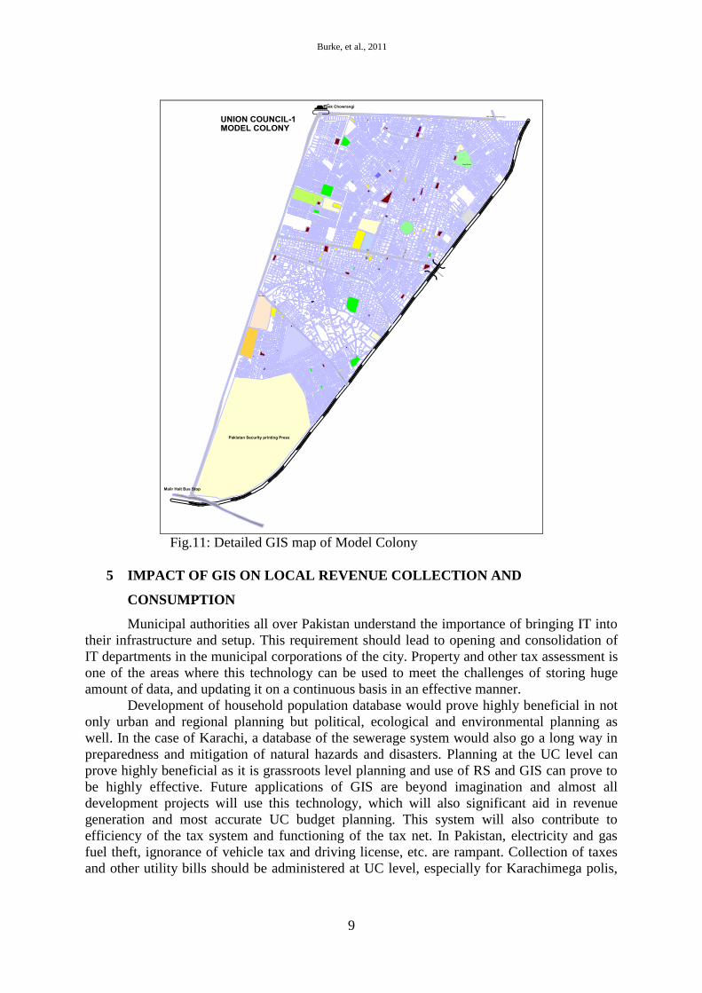
4.13 Bus Stops
Bus shelters are important components of service quality, which should be provided
by local governments. Bus stops are also an indicator of discipline of any nation, because
stops facilitate commuters for break of journey at specific points. This action mentally
motivates drivers that uncertain break is not possible in traffic flow. All should drive their
vehicles in their respective lanes and stop at relevant terminals. Shelter at bus stops is also
very important to protect from the vagaries of weather. Only one bus stop has been observed
in the entire study area.
Burke, et al., 2011
9
Fig.11: Detailed GIS map of Model Colony
5 IMPACT OF GIS ON LOCAL REVENUE COLLECTION AND
CONSUMPTION
Municipal authorities all over Pakistan understand the importance of bringing IT into
their infrastructure and setup. This requirement should lead to opening and consolidation of
IT departments in the municipal corporations of the city. Property and other tax assessment is
one of the areas where this technology can be used to meet the challenges of storing huge
amount of data, and updating it on a continuous basis in an effective manner.
Development of household population database would prove highly beneficial in not
only urban and regional planning but political, ecological and environmental planning as
well. In the case of Karachi, a database of the sewerage system would also go a long way in
preparedness and mitigation of natural hazards and disasters. Planning at the UC level can
prove highly beneficial as it is grassroots level planning and use of RS and GIS can prove to
be highly effective. Future applications of GIS are beyond imagination and almost all
development projects will use this technology, which will also significant aid in revenue
generation and most accurate UC budget planning. This system will also contribute to
efficiency of the tax system and functioning of the tax net. In Pakistan, electricity and gas
fuel theft, ignorance of vehicle tax and driving license, etc. are rampant. Collection of taxes
and other utility bills should be administered at UC level, especially for Karachimega polis,
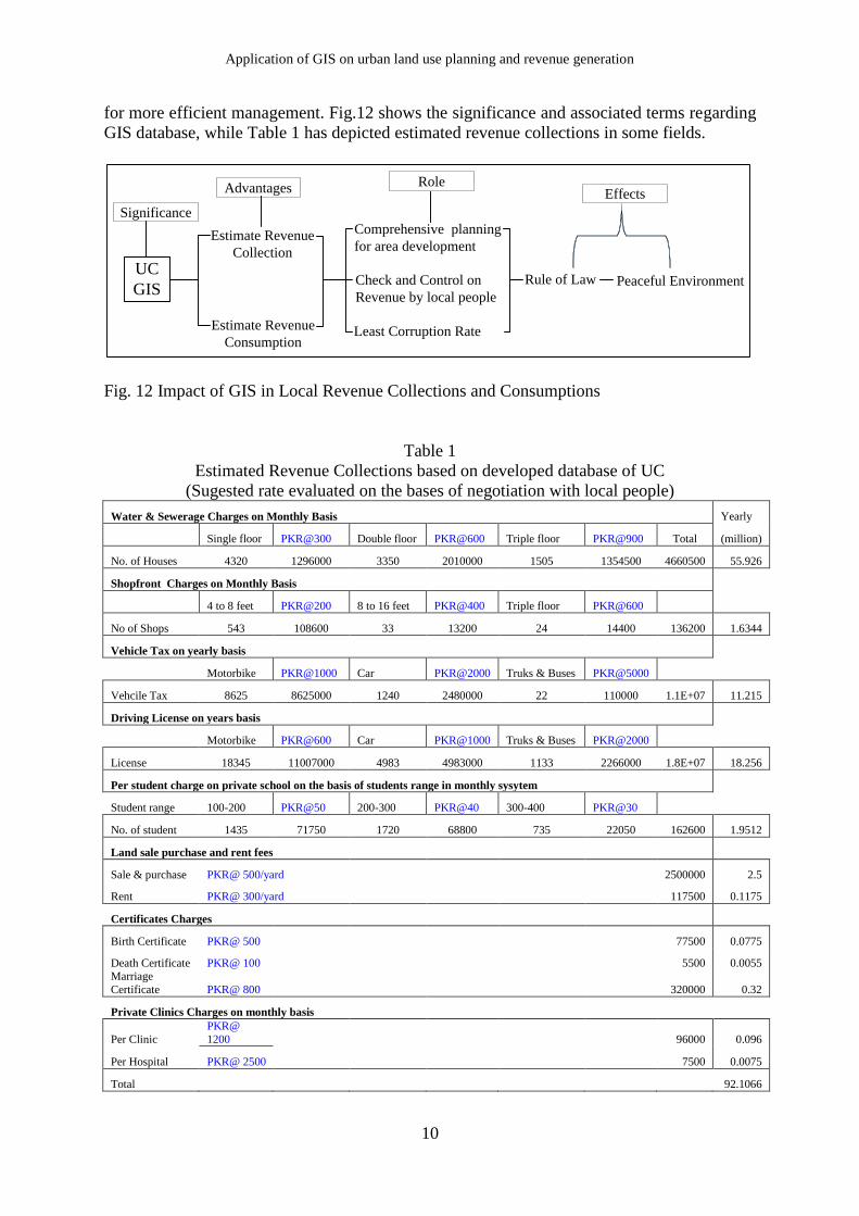
Application of GIS on urban land use planning and revenue generation
10
for more efficient management. Fig.12 shows the significance and associated terms regarding
GIS database, while Table 1 has depicted estimated revenue collections in some fields.
UC
GIS
Estimate Revenue
Collection
Estimate Revenue
Consumption
Comprehensive planning
for area development
Check and Control on
Revenue by local people
Least Corruption Rate
Rule of Law Peaceful Environment
Significance
Advantages EffectsRole
Fig. 12 Impact of GIS in Local Revenue Collections and Consumptions
Table 1
Estimated Revenue Collections based on developed database of UC
(Sugested rate evaluated on the bases of negotiation with local people)
Water & Sewerage Charges on Monthly Basis Yearly
Single floor PKR@300 Double floor PKR@600 Triple floor PKR@900 Total (million)
No. of Houses 4320 1296000 3350 2010000 1505 1354500 4660500 55.926
Shopfront Charges on Monthly Basis
4 to 8 feet PKR@200 8 to 16 feet PKR@400 Triple floor PKR@600
No of Shops 543 108600 33 13200 24 14400 136200 1.6344
Vehicle Tax on yearly basis
Motorbike PKR@1000 Car PKR@2000 Truks & Buses PKR@5000
Vehcile Tax 8625 8625000 1240 2480000 22 110000 1.1E+07 11.215
Driving License on years basis
Motorbike PKR@600 Car PKR@1000 Truks & Buses PKR@2000
License 18345 11007000 4983 4983000 1133 2266000 1.8E+07 18.256
Per student charge on private school on the basis of students range in monthly sysytem
Student range 100-200 PKR@50 200-300 PKR@40 300-400 PKR@30
No. of student 1435 71750 1720 68800 735 22050 162600 1.9512
Land sale purchase and rent fees
Sale & purchase PKR@ 500/yard 2500000 2.5
Rent PKR@ 300/yard 117500 0.1175
Certificates Charges
Birth Certificate PKR@ 500 77500 0.0775
Death Certificate PKR@ 100
5500 0.0055
Marriage
Certificate PKR@ 800 320000 0.32
Private Clinics Charges on monthly basis
Per Clinic
PKR@
1200 96000 0.096
Per Hospital PKR@ 2500 7500 0.0075
Total 92.1066
Burke, et al., 2011
11
6 DISCUSSION AND PROPOSALS
Planning is a process of human thought to be translated into action based on that
thought. Planning is forethought and its aim is to provide a resource for democratic and
informed decision-making (Hall and Page, 1999). Union Councils are administrative units
created for grass-root level planning, implementation and solution of problems which may be
highly diversified in nature covering a wide canvas of social, economic, historical,
development and recreational aspirations. Planning, however, is not a simple process and
entails the interest of a number of powerful interest groups, causing serious modifications in
the façade of democratic process. Implementation of planning decisions leaves a long-term
imprint on the structure, functionality and quality of life, especially in urban environment.
Although, most planning occurs at the local level i.e. the UC level; national and state policies
and legislation often influence the planning process and implementation. Micro-level
planning has proved to be beneficial worldwide as well as in the case of Karachi.
The use of RS and for creating GIS database is a lacune which needs to be filled in
order to provide accurate and up to-date information for handling not only planning
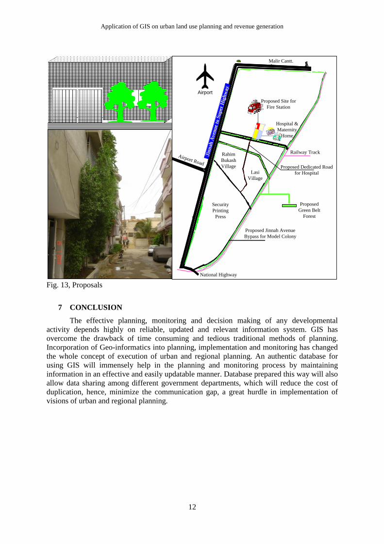
procedures but also emergency mitigation. After the development of GIS, some proposals are
given in Fig.13, because it is highly concerned with the present requirements of any well-
planned area.
Various research have found that green spaces and belts are essential components of
the urban environment as they provide a wide range of environmental and social functions to
cities and urban dwellers (Stanners and Bourdeau, 1995; Harrison et al., 1995 & Nowak et al.
2006). Increasing levels of urban densification are calling attention to those measures that can
mitigate urban island effects (Mazza and Rydin 1997) or compensate for the overload of
pollutants in (urban) air and soil (McPherson et al. 1994). A healthy urban environment is
often associated with the availability of large forest areas within cities and the accessibility of
such areas by urban residents (Hartig 2004; Hartig and Cooper- Marcus 2006; Maas, et al.
2006 & Mitchell and Popham, 2007).
Energy crisis is a critical problem in the study area. Climatic conditions force people to run
their air conditioners but shortage of electricity prevents this. Tree planting around the whole
UC green belts, roads, and big plots would help make a cool shield (Fig.13). Effective
placement of trees can benefit air quality and the health of residents while reducing energy
consumption. Trees can remove both gaseous air pollutants and particulate matter. Trees
surrounding buildings should be placed in areas that provide protection from solar radiation
in summer and block winter wind.
Fire disasters cause heavy causalities and great loss of social and economic wealth in
congested urban areas, so the plan of fire station location has an essential significance for
urban security (Chi, 2003). In the city of Karachi due to heavy traffic congestion, location of
rescue centers for provision of quick response is essential. Time-lapse in fire protection is the
most severe problem in unplanned and highly populated areas. Therefore, it is necessary to
introduce multi objective models for location of fire station and emergency centers (Badri, et
al., 1998; Araz, et al., 2007).
Based on geographical network models and GIS spatial analysis, an optimized arithmetic of
the fire station locations as well as the coverage area boundaries are designed (Malczewski,
2004). Unfortunately, in the study area, none of the fire stations are located at vantage points
for UC administration to make proper spatial allocation of this facility. Fig.13 shows the
proposal for location of this facility. Due to centralized location of commercial centers, it is
very essential to design a bypass for reducing traffic congestion towards residential areas. In
the study area, it is easy to make a bypass entitled Jinnah bypass for decreasing of overburden
of Jinnah Avenue because subsequent to the link with the super highway, the volume of
heavily traffic has increased tremendously.
Application of GIS on urban land use planning and revenue generation
12
Jin
nah
Aven
ue
to S
up
er H
igh
way
Proposed Site for
Fire Station
Railway Track
Proposed
Green Belt
Forest
Proposed Jinnah Avenue
Bypass for Model Colony
Security
Printing
Press
Hospital &
Maternity
Home
Airport
Malir Cantt.
Proposed Dedicated Road
for Hospital
National Highway
Airport Road
Rahim
Bukash
Village
Lasi
Village
Fig. 13, Proposals
7 CONCLUSION
The effective planning, monitoring and decision making of any developmental
activity depends highly on reliable, updated and relevant information system. GIS has
overcome the drawback of time consuming and tedious traditional methods of planning.
Incorporation of Geo-informatics into planning, implementation and monitoring has changed
the whole concept of execution of urban and regional planning. An authentic database for
using GIS will immensely help in the planning and monitoring process by maintaining
information in an effective and easily updatable manner. Database prepared this way will also
allow data sharing among different government departments, which will reduce the cost of
duplication, hence, minimize the communication gap, a great hurdle in implementation of
visions of urban and regional planning.
Burke, et al., 2011
13
REFERENCES
(EBGGH) Environmental Building Guidelines for Greater Hyderabad (2010). Minimum local
amenities requirements in order to reduce private vehicle use, Energy, Ene. Nh 4, Phase 2 -
Environmental Building Initiative for Greater Hyderabad—by TERI and TVPL
Ahmed M. M (2008), GIS Modeling for Health Reform in Rural Government of Egypt.
http://gisdevelopment.net/procedings/gisdeco/sessions/tl l_mostafapf.html
Araz, C., Selim, H. and Ozkarahan, I. (2007). A fuzzy multi-objective covering-based
vehicle location model for emergency services, Computers & Operations Research, 34(3):
705-726
Ayan, M. and Taspinar, M. (2009). From OKS to SBS, new approach in secondary education
transition system in Turkey, Procedia Social and Behavioral Sciences, 1(1):2696-2700
Badri, M. A., Mortagy, A.K. and Alsayed, A. (1998). A multi-objective model for locating
fire stations, European Journal of Operational Research, 110(2): 243-260
Bennett, R.J., Fuller, C. and Ramsden, M. (2004) Local government and local economic
development in Britain: an evaluation of developments under labour, Progress in Planning, 62
(4): 207-207
Burke, F., Azam, M., Huda, N.S. and Hamza, S. (2007). Open Green Spaces - Asset or
Liability-Case Study of North Nazimabad Town-Karachi, Karachi University Journal of
Science, 35: 23-30
Burke, F., Huda, S.N. Azam, M., Hamza, S. and Haq, Q. (2009). Classification and
Standardization of Parks: North Nazimabad Karachi, Pakistan, Australian Journal of Applied
Sciences, 3(2): 853-865
Chi, C. and Aizhu, R. (2003). Optimization of fire station locations using computer. J T
singhua Univ (Sci & Tech). 43(10):1390-1393.
Cho, S., Poudyal, N.C. and Roberts, R. K. (2008). Spatial analysis of the amenity value of
green open space, Ecological Economics, 66(2-3): 403-416
Civco, D.L., Hurd, J.D., Wilson, E.H., Arnold, C.L., Prisloe, M. (2002). Quantifying and
describing urbanizing landscapes in the Northeast United States. Photogrammetr. Eng.
Remote Sens, 68(10): 1083–1090.
Clercq, F. le. (1990). Information Supply to Strategic Planning. Environment and Planning B:
Planning and Design, 17: 429-40.
Devogele, T., Parent, C., and Spaccapietra, S. (1998). On spatial database integration.
International Journal of Geographical Information Science, 12(4): 335-352
Floyd, F. F., Taylor W. C. and Whitt-Glover, M. (2009). Measurement of Park and
Recreation Environments That Support Physical Activity in Low-Income Communities of
Application of GIS on urban land use planning and revenue generation
14
Color: Highlights of Challenges and Recommendations, American Journal of Preventive
Medicine, 36(4):156-160
Georgiadou, Y. and Stoter, J. (2010). Studying the use of geo-information in government- A
conceptual framework Original Computers. Environment and Urban Systems, 341: 70-78
GoP, (2000). District Census Report - Karachi East, 1998. Rawalpindi,
Grignon, M. (2008). The role of education in health system performance, Economics of
Education Review, 27(3): 299-307
Hall, C.M. and Page, S.J., (1999). The Geography of Tourism and Recreation: Environment,
Place and Space, New York, Routladge.
Harrison, C., Burgess, J., Millward, A., Dawe, G. (1995). Accessible natural green space in
towns and cities – a review of appropriate size and distance criteria. English Nature Research
Reports, vol. 153. English Nature, Peterborough.
Hartig, T. & Cooper Marcus, C., (2006). Healing gardens – Places for nature in healthcare.
The Lancet, 368: 36-37
Hudson, W.R., Haas, R., and Uddin, W. (1997) Infrastructure Management: Integrating
Design, Construction, Maintenance, Rehabilitation, and Renovation. McGraw-Hill, New
York.
ICIMOD, (1999). Integration of GIS, remote sensing and ecological methods for biodiversity
inventory and assessment. In Issues in Mountain Development.
Langdon, P. (2003). Public Buildings Keep Town Centers Alive, Planning Commission, 49:
1-7
Maas, J., Erheij, R.A., Groenewegen, P.P., de Vries, S., Spreeuwenberg, P. (2006). Green
space urbanity, and health: how strong is the relation? J. Epid. Community Health 60: 587-
592.
Malczewski, J. (2004). GIS-based land-use suitability analysis: a critical overview, Progress
in Planning, 62(1): 3-65
Mansouri B., Ghafory-Ashtiany, M. (2007). Application of Remote Sensing and GIS
Techniques in Seismic Risk Management of Tehran, 5th Conference on Seismology and
Earthquake Engineering– Paper No: ER18, SEE5 – Tehran.
Mansouri B., Ghafory-Ashtiany M., Amini-Hosseini K., Ghayamghamian M.R., Nourjou R.,
and Mousavi M., (2008). Urban Seismic Loss Estimation using Optical and Radar Satellite
Imagery and GIS, International Institute of Earthquake Engineering and Seismology, contract
No. 327-8302: Tehran, Iran, 2008.
Mazza, L. and Rydin, Y. (1997). Urban sustainability: discourses, networks and policy tools.
Prog. Plann. 47:1–74.
Burke, et al., 2011
15
McPherson, E.G., Nowak, D.J. and Rowntree, R.A. (1994). Chicago's Urban Forest
Ecosystem: Results of the Chicago Urban Forest Climate Project. United States Department
of Agriculture Forest Service Northeastern Forest Experiment Station General Technical
Report N E- 1 86.
Mitchell, R., Popham, F. (2007). Greenspace, urbanity and health: relationship in England. J.
Epid. Community Health, 61: 681-683.
MPGO-CDGK, (2008), Karachi Strategic Development Plan 2020, Prepared by Master Plan
Group of Offices City District Government Karachi.
Nowak, D.J., Crane, D.E. and Stevens, J.C. (2006). Air pollution removal by urban trees and
shrubs in the United States. Urban Forestry & Urban Greening 3-4:115-123.
Qiong Wu, Q., Li, H., Wang, R., Paulussen, J., He, Y., Wang, M., Wang, B. and Wang, Z.
(2006). Monitoring and predicting land use change in Beijing using remote sensing and GIS,
Landscape and Urban Planning, 78: 322–333
Rodríguez-Pose, A., Tomaney, J. and Klink, J. (2001). Local empowerment through
economic restructuring in Brazil: the case of the greater ABC region, Geoforum, 32(4): 459-
469
Santosa, W. and Joewono, T. B. (2005). An Evaluation of Road Network Performance in
Indonesia, Proceedings of the Eastern Asia Society for Transportation Studies, 5: 2418 - 2433
Schulman, A and Peters C.A (2007). GIS analysis of urban schoolyard land cover in three
U.S. cities. Springer Science & Business Media, LLC.
Stanners, D., Bourdeau, P. (1995). The urban environment. In: Stanners, D., Bourdeau, P.
(Eds.), Europe’s Environment: The Dobris Assessment. European Environment Agency,
Copenhagen: 261–296.
Sudhira, S.H., Ramachandra, V.T. and Jagadish, S.K. (2004). Urban sprawl: metrics,
dynamics and modelling using GIS, International Journal of Applied Earth Observation and
Geoinformation, 5:29-39
Sui, D. Z. (1998). GIS-Based Urban Modeling: Practices, Problems, and Prospects, Systems
8(5): 451-470.
Thomas, R.M. (2002). A GIS-based decision support system for Brownfield redevelopment.
Landscape and Urban Planning, 58:7-23
Warnecke, L., Beattie, J., Cheryl, K., Lyday, W. and French, S. (1998). Geographic
Information Technology in Cities and Counties: A Nationwide Assessment (Washington,
DC: American Forests).
Webster, C.J. (1993). GIS and the Scientific Inputs to Urban Planning. Part 1: Description.
Environment and Planning B, 20(6): 709-728.
Webster, C.J. (1994). GIS and the Scientific Inputs to Urban Planning. Part 2: Prediction and
Prescription. Environment and Planning B, 21(2):145-157.
Application of GIS on urban land use planning and revenue generation
16
Wellar, B., Nairne, C. and Michael, S. (1994), Progress in Building Linkages Between GIS
and Methods and Techniques of Scientific Inquiry, Computers, Environment, and Urban
Systems, 18(2): 67-80.
World Health Organization (2007). World Health Report, 2007. A Safer Future: Global
Public Health Security in the 21st Century.
Wong, C. (2001) The Relationship Between Quality of Life and Local Economic
Development: An Empirical Study of Local Authority Areas in England, Cities, 18(1): 25-32
Xia Li, X. and Yeh, G.A., (2004), Analyzing spatial restructuring of land use patterns in a
fast growing region using remote sensing and GIS, Landscape and Urban Planning, 69: 335–
354
Yeh, A. G-O. (1999). Urban Planning and GIS in Longley, P. A., et. al. (eds). Geographical
Information Systems: Principles and Technical Issues. 2nd Edition, 2: 877-887, John Wiley
&Sons
Zigelbauer, R., Ryan, B. and Grabow, S. (2005). The Importance of Government Facilities in
Downtowns: An Analysis of Business Establishments in Wisconsin’s County Seats, UW-
Extension: 1-12.