Embed Size (px)
Citation preview
Hyunjung, Ha | Korean Cadastra l Survey Corp ./South Korea | 2012.05
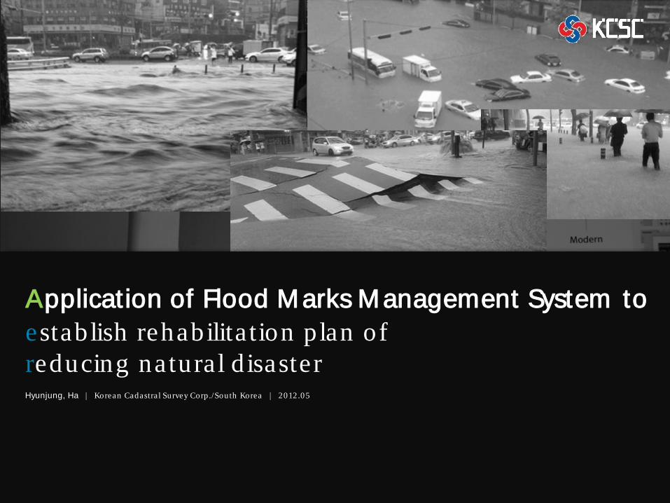
Application of Flood Marks Management System to establish rehabilita tion p lan of reducing natural d isaster
1-1 Background
1-2 Form er Problem s of Making FMS
1-3 Institute responsible for FMS
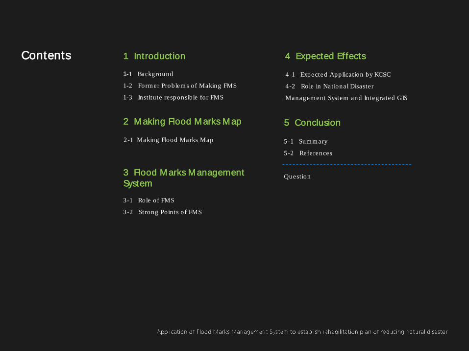
1 Introduction
2 Making Flood Marks Map
2-1 Making Flood Marks Map
3 Flood Marks Management System
3-1 Role of FMS
3-2 Strong Points of FMS
4 Expected Effects
4-1 Expected Application by KCSC
4-2 Role in National Disaster
Managem ent System and Integrated GIS
5 Conclusion
5-1 Sum m ary
5-2 References
Question
Contents
Chapter 1
Introduction
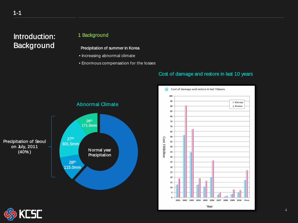
Precipitation of summer in Korea
1 Background
• Increasing abnormal climate
• Enormous compensation for the losses
1-1
Introduction: Background
Abnormal Climate
26th 171.0mm
27th 301.5mm
28th 115.0mm
Normal year Precipitation
Precipitation of Seoul on July, 2011
(40% )
Cost of damage and restore in last 10 years
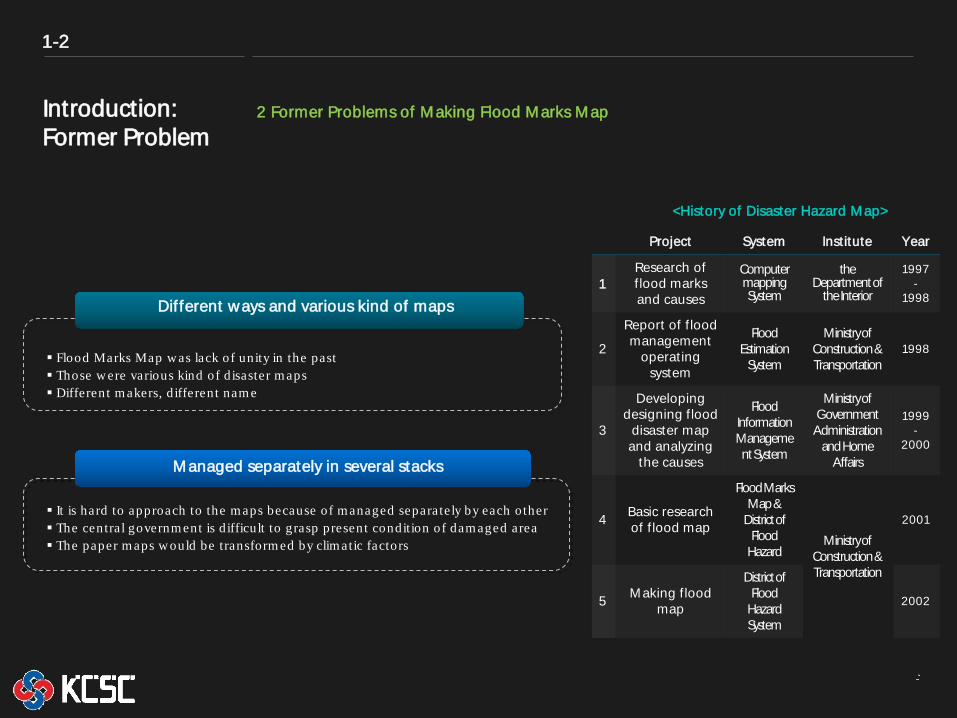
Introduction: Former Problem
2 Former Problems of Making Flood Marks Map
Project System Institute Year
1 Research of f lood marks and causes
Computer mapping System
the Department of
the Interior
1997-
1998
2
Report of f lood management
operating system
Flood Estimation
System
Ministry of Construction & Transportation
1998
3
Developing designing f lood
disaster map and analyzing
the causes
Flood Information Management System
Ministry of Government Administration
and Home Affairs
1999-
2000
4 Basic research of f lood map
Flood Marks Map &
District of Flood
Hazard Ministry of
Construction & Transportation
2001
5 Making f lood map
District of Flood
Hazard System
2002
1-2
Different ways and various kind of maps
Managed separately in several stacks
It is hard to approach to the m aps because of m anaged separately by each other The central governm ent is d ifficult to grasp present condition of dam aged area The paper m aps w ould be transform ed by clim atic factors
Flood Marks Map w as lack of unity in the past Those w ere various kind of d isaster m aps Different m akers, d ifferent nam e
<History of Disaster Hazard Map>
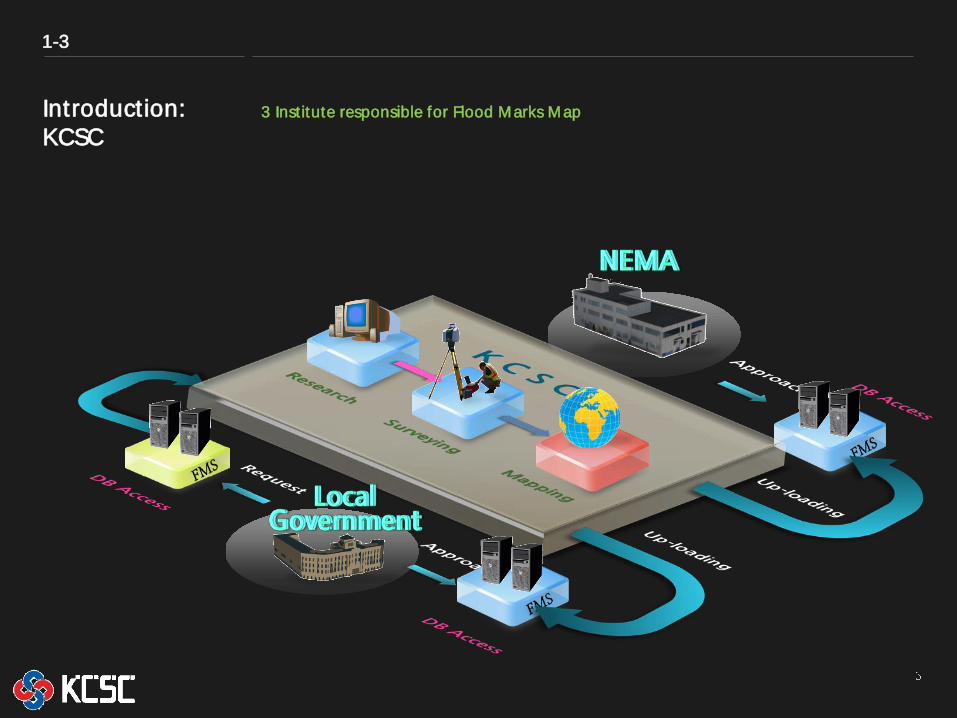
Introduction: KCSC
3 Institute responsible for Flood Marks Map
1-3
Chapter 2
Making Flood Marks Map
Making Flood Marks Map: Process
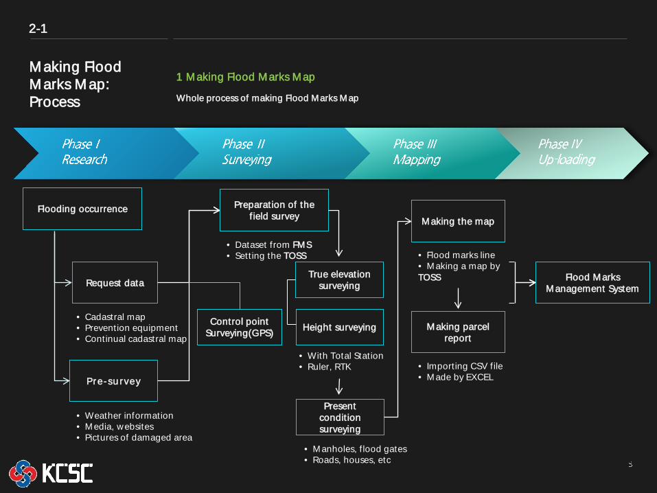
1 Making Flood Marks Map
Whole process of making Flood Marks Map
2-1
Flooding occurrence
• Cadastral map • Prevention equipment • Continual cadastral map
Pre-su rvey
• Weather information • Media, websites • Pictures of damaged area
Request data
Preparation of the f ield survey
Control point Surveying(GPS)
True elevation surveying
• With Total Station • Ruler, RTK
Present condit ion surveying
• Dataset from FMS • Sett ing the TOSS
• Manholes, f lood gates • Roads, houses, etc
Making the map
• Flood marks line • Making a map by TOSS
Making parcel report
• Importing CSV file • Made by EXCEL
Flood Marks Management System
Height surveying
Making Flood Marks Map: Process
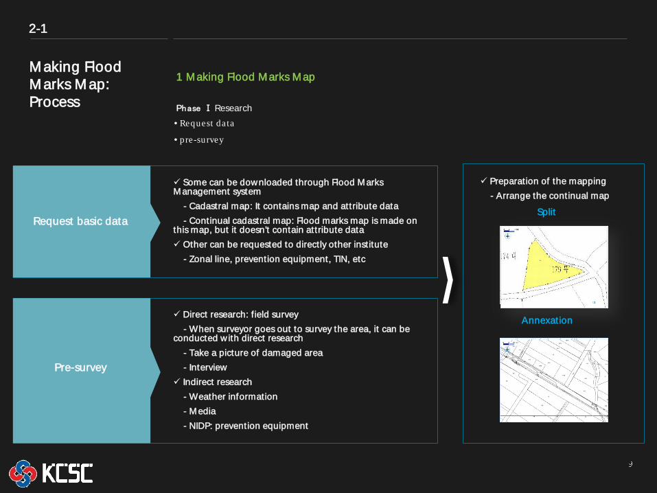
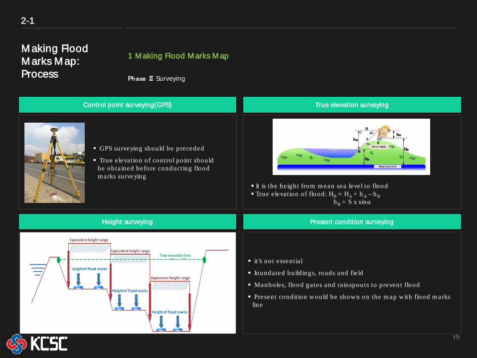
1 Making Flood Marks Map Phase Ⅰ Research
2-1
Some can be downloaded through Flood Marks Management system - Cadastral map: It contains map and attribute data - Continual cadastral map: Flood marks map is made on this map, but it doesn’t contain attribute data Other can be requested to directly other institute - Zonal line, prevention equipment, TIN, etc
Request basic data
• Request data
• pre-survey
Direct research: f ield survey - When surveyor goes out to survey the area, it can be conducted w ith direct research - Take a picture of damaged area - Interview Indirect research - Weather information - Media - NIDP: prevention equipment
Pre-survey
Preparation of the mapping - Arrange the continual map
Split
Annexation
Making Flood Marks Map: Process
1 Making Flood Marks Map
2-1
Phase Ⅱ Surveying
Control point surveying(GPS) True elevation surveying
Present condition surveying
it’s not essentia l
Inundated buildings, roads and fie ld
Manholes, flood gates and rainspouts to prevent flood
Present condition w ould be show n on the m ap w ith flood m arks line
Height surveying
It is the height from land to flood m arks
It has 7 levels having an in terval per every 50cm
There are 2 kinds of surveying:
- Range of the equivalent height survey
- Height of flood m arks : 3-4 points w ith in sam e range
GPS surveying should be preceded
True e levation of control point should be obtained before conducting flood m arks surveying
It is the height from m ean sea level to flood True e levation of flood: HB = HA + h A – h B
h B = S x sinα
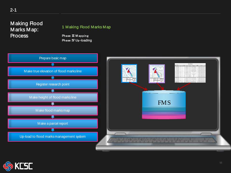
Making Flood Marks Map: Process
Prepare basic map
Make true elevation of flood marks line
Register research point
Make height of flood marks line
Make flood marks map
Make a parcel report
Up-load to flood marks management system
2-1
1 Making Flood Marks Map
Phase Ⅲ M app ing Phase Ⅳ Up -loading
From KCSC 2008
FMS
Chapter 3
Flood Marks Management System
Flood Marks Management System: Role
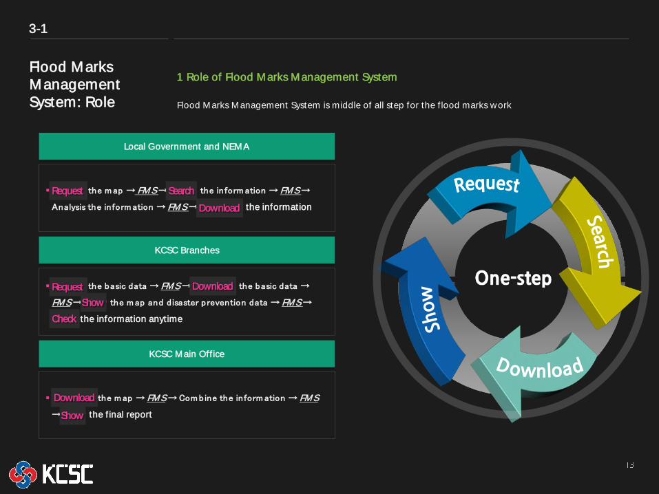
1 Role of Flood Marks Management System
Flood Marks Management System is middle of all step for the f lood marks work
3-1
Local Government and NEMA
Request the m ap → FMS → Search the inform ation → FMS →
Analysis the inform ation → FMS → Download the information
KCSC Branches
Request the basic data → FMS → Download the basic data →
FMS → Show the m ap and d isaster prevention data → FMS →
Check the information anytime
KCSC Main Off ice
Download the m ap → FMS → Com bine the inform ation → FMS
→ Show the f inal report
Request Search
Download
Request Download
Download
Show
Show
Check
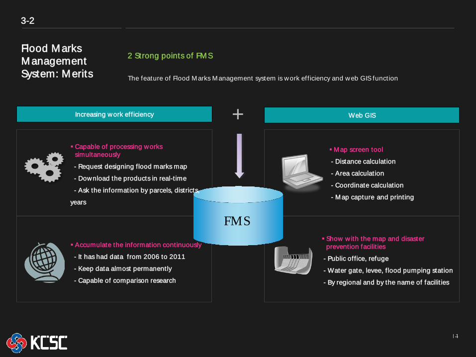
Flood Marks Management System: Merits
2 Strong points of FMS
3-2
FMS
Increasing work eff iciency Web GIS +
The feature of Flood Marks Management system is work eff iciency and web GIS function
Capable of processing works simultaneously
- Request designing f lood marks map
- Download the products in real-t ime
- Ask the information by parcels, districts,
years
Accumulate the information continuously
- It has had data from 2006 to 2011
- Keep data almost permanently
- Capable of comparison research
Map screen tool
- Distance calculation
- Area calculation
- Coordinate calculation
- Map capture and printing
Show w ith the map and disaster prevention facilit ies
- Public off ice, refuge
- Water gate, levee, f lood pumping station
- By regional and by the name of facilit ies
Chapter 4
Expected Effect
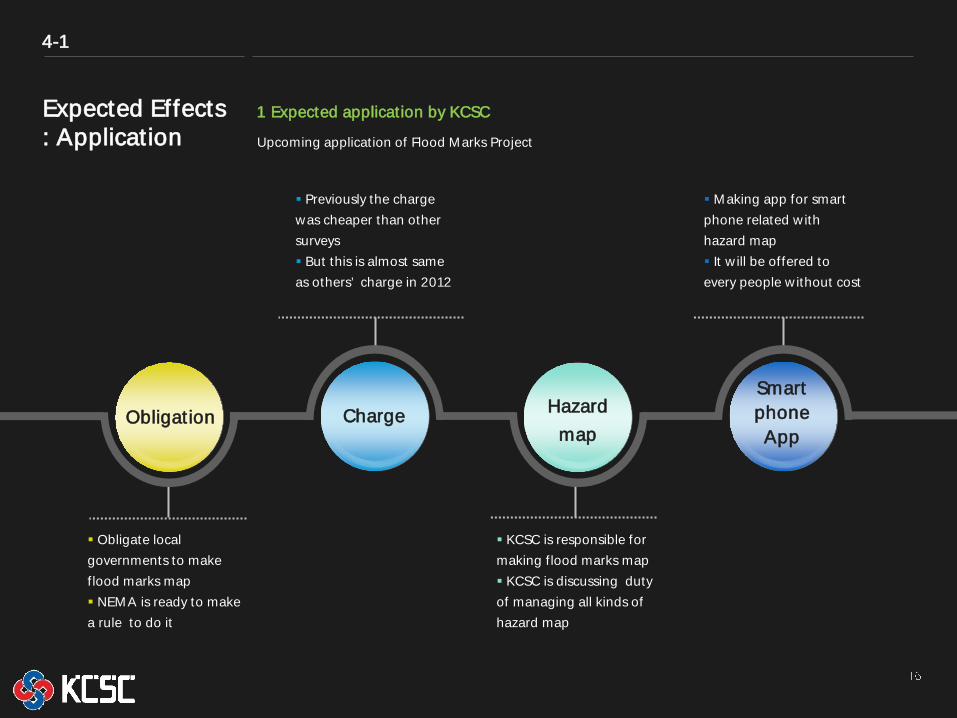
Expected Effects : Application
1 Expected application by KCSC
4-1
Obligate local governments to make f lood marks map NEMA is ready to make a rule to do it
Obligation Charge Hazard map
Smart phone App
Making app for smart phone related w ith hazard map It w ill be offered to every people w ithout cost
Previously the charge was cheaper than other surveys But this is almost same as others’ charge in 2012
KCSC is responsible for making f lood marks map KCSC is discussing duty of managing all kinds of hazard map
Upcoming application of Flood Marks Project
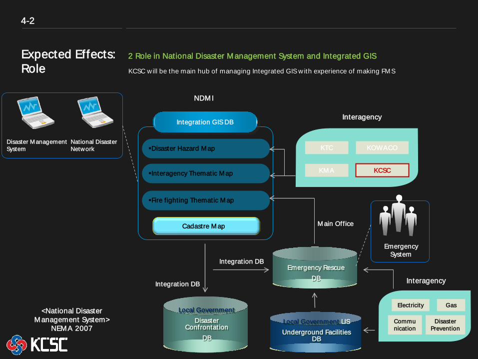
Expected Effects: Role
2 Role in National Disaster Management System and Integrated GIS
KCSC w ill be the main hub of managing Integrated GIS w ith experience of making FMS
Disaster Management System
National Disaster Network
NDMI
Interagency Integration GIS DB
Disaster Hazard Map
Interagency Thematic Map
Fire f ighting Thematic Map
Cadastre Map
KTC
KMA
KOWACO
KCSC
Local Government Disaster
Confrontation DB
Emergency Rescue DB
Local Government LIS Underground Facilit ies
DB
Emergency System
Interagency
Electricity
Communication
Gas
Disaster Prevention
Integration DB
Integration DB
Main Off ice
4-2
<National Disaster Management System>
NEMA 2007
Chapter 5
Conclusion
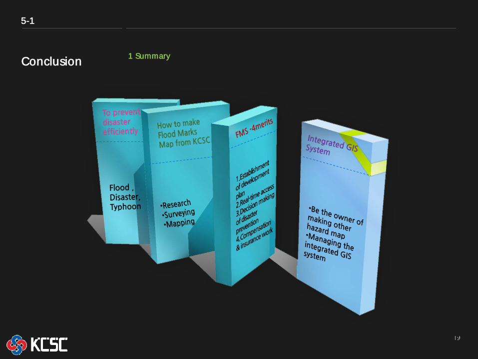
Conclusion 1 Summary
5-1
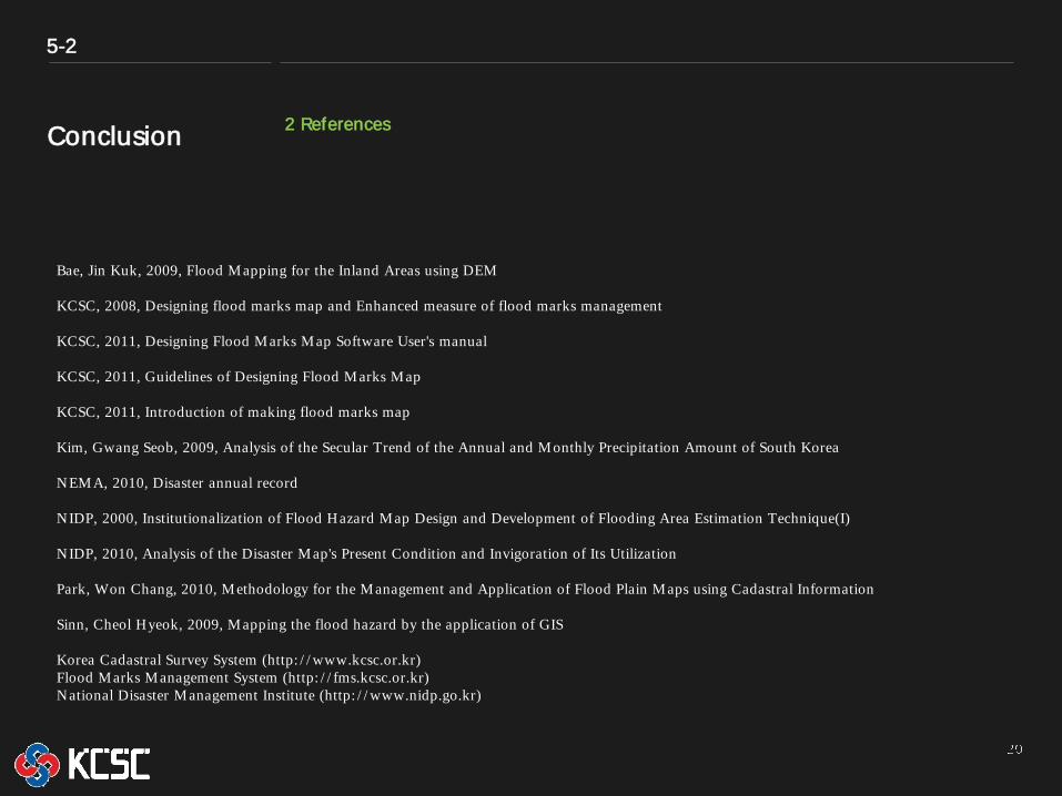
Conclusion 2 References
5-2
Bae, Jin Kuk, 2009, Flood M apping for the Inland Areas using DEM KCSC, 2008, Designing flood marks map and Enhanced measure of flood marks management KCSC, 2011, Designing Flood M arks M ap Software User's manual KCSC, 2011, Guidelines of Designing Flood M arks M ap KCSC, 2011, Introduction of making flood marks map Kim, Gwang Seob, 2009, Analysis of the Secular Trend of the Annual and M onthly Precipitation Amount of South Korea NEM A, 2010, Disaster annual record NIDP, 2000, Institutionalization of Flood Hazard M ap Design and Development of Flooding Area Estimation Technique(I) NIDP, 2010, Analysis of the Disaster M ap's Present Condition and Invigoration of Its Utilization Park, Won Chang, 2010, M ethodology for the M anagement and Application of Flood Plain M aps using Cadastral Information Sinn, Cheol Hyeok, 2009, M apping the flood hazard by the application of GIS Korea Cadastral Survey System (http: / / www.kcsc.or.kr) Flood M arks M anagement System (http: / / fms.kcsc.or.kr) National Disaster M anagement Institute (http: / / www.nidp.go.kr)

Thank you.
Q&A