Embed Size (px)
Citation preview
Application of CHARM® for studying chemical dispersion due to accidental release
S. Abdullah CESAT, Pakistan
Abstract
The EPA risk management program (RMP, Rule 112r) requires hazard assessment and emergency response programs. To assure that you have adequate resources and that plans are well organized for any contingency, you need to plan for emergency response. Should such an accident occur, you need real time data to guide the response activities (CHARM – Software, when realism counts, www.charmmodel.com). An example given in this paper helps the planner to understand how dispersion modelling can help to guide response activities. There are two versions of CHARM; the first deals with a flat terrain and second deals with a complex terrain. Both use different types of algorithms. In a flat terrain, release is simulated as it simulates a series of puffs, while in a complex terrain, release is determined by the fundamental equations of Navier-Stokes. The CHARM® software is an application that calculates the movement and concentration of airborne plumes from released chemicals; thermal radiation impacts from fires; and overpressures from mechanical and vapour cloud explosions. In this paper the complex terrain version of CHARM is being used and instantaneous release of 50 kg Chlorine is being considered to explain the simulation process. It is worth mentioning that hazard assessment could be done in a cost effective manner using data mostly available free of cost, like satellite images, digital elevation model, digital surface model, chemical properties of released chemicals, surface roughness data and meteorological parameters. Keywords: CHARM, Complex Hazardous Air Release Model, dispersion model, hazard assessment, chemical release, accidental release, complex terrain, Chlorine.
Environmental Impact II 705
www.witpress.com, ISSN 1743-3541 (on-line) WIT Transactions on Ecology and The Environment, Vol 181, © 2014 WIT Press
doi:10.2495/EID140601
1 Introduction
It is always a matter of concern for strategic planners as well as those involves in emergency response planning that what will be the extent of any potential release for specific period of time. Sometimes they require monitoring the actual scenario to guide the response activities. People involve in disaster management also like to see visual impact on map for rescue operations and evacuations plans through identification of potential hazard zone so that priority areas for their operation could be marked. There are several models available which can be used to address the answer such type of questions and CHARM® is one of them. CHARM® (Complex Hazardous Air Release Model) is sophisticated modelling software and it requires several sets of data to perform effective simulation and using resource mostly available free of cost how it would be done is main aim of this paper.
2 Materials
2.1 Satellite base map
A base map of any point of interest can be downloaded through Google Earth®. This is the requirement to visualize the scenario and to see the extent of dispersion. Other software like Bing® and Yahoo maps® may be used. Depending upon the requirement of the task free available images can fulfil the most of the requirements. If someone needs very high resolution images then are available on cost for almost entire World. Downloaded maps through Google Earth or through any other free resources are normally in the form of JPEG and hence not geo-referenced. To make them geo-referenced CHARM® provides CharmEd (as a part of its installations files) for geo-referencing. Under ‘map definition’ option user can define point, scale, map location and release location. Alternatively, a mapping program CHARMInetMaps can be used. This mapping software can be downloaded from CHARM website as a freeware. Maps downloaded through CHARMInetMaps are geo-referenced by default. CHARMInetMaps facilitates to download satellite images either from Google, Yahoo and Bing with several scales of spatial resolutions to fit in user requirement. The saved maps can be opened directly into CharmEd or in CHARM® main program.
2.2 DEM (digital elevation model)
DEM is used in the model to depict actual terrain information to have factual picture about the land. It can be downloaded from mapping resource sites. DEM with 30 meter resolution is available free of cost in the format which is compatible with latest version of CHARM and can be downloaded from the GDEM website [4].
706 Environmental Impact II
www.witpress.com, ISSN 1743-3541 (on-line) WIT Transactions on Ecology and The Environment, Vol 181, © 2014 WIT Press
2.3 Google sketchup file
Google sketchup® software can be used to draw 3D buildings. Alternatively several sketchup models are available to download from Google Trimble data warehouse [5]. The Google Sketchup community is uploading 3D buildings constantly from round the globe and anyone may find them for their own area of interest. Google building maker software can also be used to draw 3D buildings but unfortunately it will be retired June 1, 2013 [6]. In this paper, DEM is being considered while sketchup files are not being used.
2.4 Surface roughness data
Surface roughness is a measure of the interaction between the wind and the surface [7]. It affects wind speed with altitude. A single file for Surface Roughness for the entire world can be downloaded from the USGS website [8].This is called GLCC (global land cover characterization) data. Some examples of surface roughness are mentioned in Table 1.
Table 1: Surface roughness examples [9].
Surface Roughness (cm) Smooth mud flats; ice 0.001 Smooth snow 0.005 Smooth sea 0.02 Level desert 0.03 Snow surface; lawn to 1cm high 0.1 Lawn, grass to 5 cm 1–2 Lawn, grass to 60 cm 4–9 Fully grown root crops 14 Parkland, bushes 50 Large obstacle; suburb, forest 50–100
2.5 Meteorological parameters
CHARM® requires meteorological information like ambient temperature, pressure, wind direction, wind speed and stability class. This information of any station can be entered in several ways. It can be either entered manually in main CHARM data input screen. Once data is entered it can be saved as met file with .met extension and saved met file can be opened next time. Meteorological data can be acquired through other sources like Portable Meteorological station and through National Weather Services (NWS) website [10]. NWS weather information hourly basis and CHARM update its plume too whenever meteorological information changes. But to excess NWS data directly from CHARM there is a need to have meteorological interface software MetInter but
Environmental Impact II 707
www.witpress.com, ISSN 1743-3541 (on-line) WIT Transactions on Ecology and The Environment, Vol 181, © 2014 WIT Press
this is not free of cost. On the other hand manual entry of meteorological information can be used as a substitute.
2.6 Chemical parameters
Physical properties of chemicals as well as physico-chemical properties play a key role to simulate the release. Fortunately CHARM is available with required properties of 200+ chemicals. These properties include mol. weight, boiling point, melting point, triple point temp. and pressure, critical temp., pressure and volume, heat of vaporization, surface tension of liquid phase, liquid density, vapour heat capacity etc. A minimum amount of chemical data is required to perform a simulation. If more data is provided, other impacts such as fires and explosions can also be calculated.
3 Methods
3.1 Acute exposure guideline levels
The AEGL (acute exposure guideline levels) are needed to be set first. The NAC (National Advisory Committee), USA developed AEGL for high priority toxic chemicals [11]. The three AEGLs for Chlorine are given in Table 2. These levels can be set through Isopleth concentration within CHARM.
Table 2: AEGL for Chlorine.
Guideline Threat type Quantity in ppm against exposure time 10 min 30 min 1 hr 4 hrs 8 hrs
AEGL-1 Discomfort, non disabling
0.5 0.5 0.5 0.5 0.5
AEGL-2 Irreversible long lasting
2.8 2.8 2.0 1.0 0.71
AEGL-3 Life threat or death
50 28 20 10 7.1
3.2 Base map
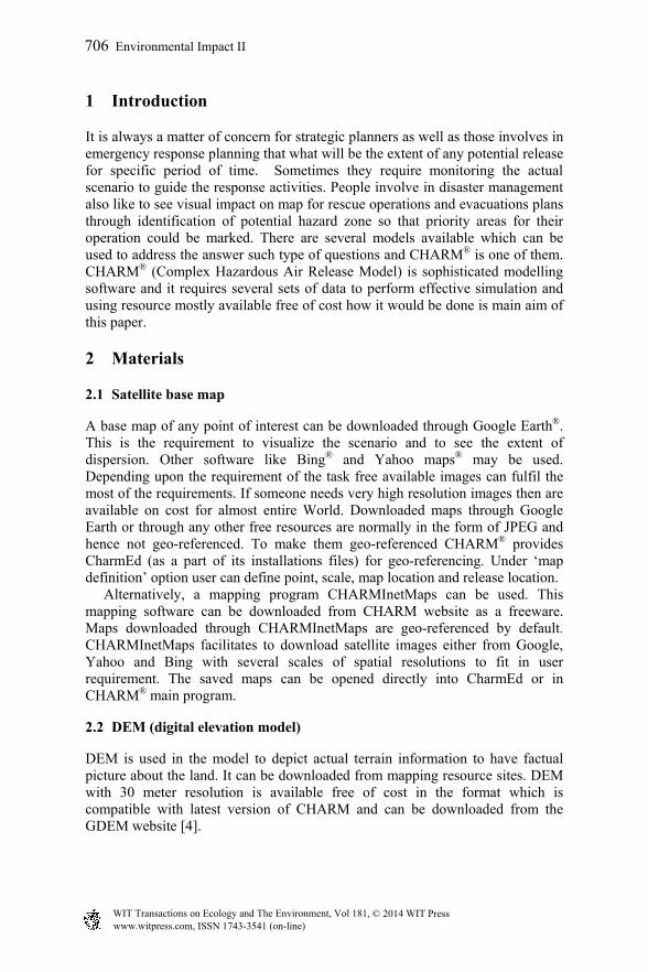
CHARMInetMaps is being used to download map for selected area. As already discussed that map downloaded through CHARMInetMaps are geo-referenced by default. Figure 1 is a ready to use map downloaded through CHARMInetMaps and it is geo-referenced. Map is now opened in CharmEd for further processing.
3.3 DEM
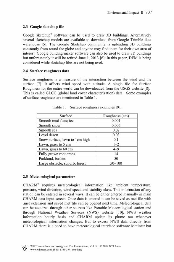
DEM (digital elevation model) of 30m resolution was downloaded from GDEM website and then viewed under grid option within CharmEd. It is noted that the
708 Environmental Impact II
www.witpress.com, ISSN 1743-3541 (on-line) WIT Transactions on Ecology and The Environment, Vol 181, © 2014 WIT Press
Figure 1: Map of selected area downloaded through CHARMInetMaps.
Figure 2: Each grid showing DEM (digital elevation model) projection.
map has been divided in block as each block represent single value of elevation in Figure 2. Grid size is adjustable and can be customized.
3.4 Surface roughness data
Surface roughness data can be entered by simply selected GLCC data file within CharmEd. It is noted that each grid represents surface roughness value similar to the DEM value. Now both DEM and surface roughness can be viewed by selecting relevant option. By double clicking on any grid user can see detail analysis of surface roughness. This option is also available with screen showing DEM.
Environmental Impact II 709
www.witpress.com, ISSN 1743-3541 (on-line) WIT Transactions on Ecology and The Environment, Vol 181, © 2014 WIT Press
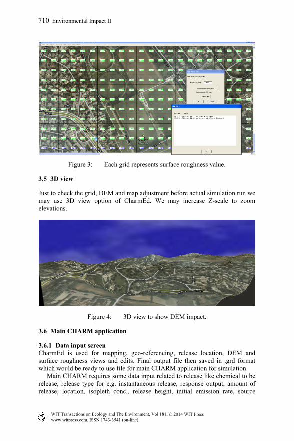
Figure 3: Each grid represents surface roughness value.
3.5 3D view
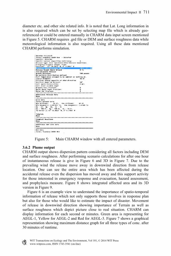
Just to check the grid, DEM and map adjustment before actual simulation run we may use 3D view option of CharmEd. We may increase Z-scale to zoom elevations.
Figure 4: 3D view to show DEM impact.
3.6 Main CHARM application
3.6.1 Data input screen CharmEd is used for mapping, geo-referencing, release location, DEM and surface roughness views and edits. Final output file then saved in .grd format which would be ready to use file for main CHARM application for simulation. Main CHARM requires some data input related to release like chemical to be release, release type for e.g. instantaneous release, response output, amount of release, location, isopleth conc., release height, initial emission rate, source
710 Environmental Impact II
www.witpress.com, ISSN 1743-3541 (on-line) WIT Transactions on Ecology and The Environment, Vol 181, © 2014 WIT Press
diameter etc. and other site related info. It is noted that Lat. Long information in is also required which can be set by selecting map file which is already geo-referenced or could be entered manually in CHARM data input screen mentioned in Figure 5. CHARM requires .grd file or DEM and surface roughness data while meteorological information is also required. Using all these data mentioned CHARM performs simulation.
Figure 5: Main CHARM window with all entered parameters.
3.6.2 Plume output CHARM output shows dispersion pattern considering all factors including DEM and surface roughness. After performing scenario calculations for after one hour of instantaneous release is give in Figure 6 and 3D in Figure 7. Due to the prevailing wind the release move away in downwind direction from release location. One can see the entire area which has been affected during the accidental release even the dispersion has moved away and this support activity for those interested in emergency response and evacuation, hazard assessment, and prophylaxis measure. Figure 8 shows integrated affected area and its 3D version in Figure 9. Figure 6 is an example view to understand the importance of spatio-temporal information of release which not only supports those involves in response plan but also for those who would like to estimate the impact of disaster. Movement of release in downwind direction showing importance of Terrain as well as surface roughness which depict picture close to real situation. CHARM can display information for each second or minutes. Green area is representing for AEGL-1, Yellow for AEGL-2 and Red for AEGL-3. Figure 7 shows a graphical representation showing maximum distance graph for all three types of conc. after 30 minutes of runtime.
Environmental Impact II 711
www.witpress.com, ISSN 1743-3541 (on-line) WIT Transactions on Ecology and The Environment, Vol 181, © 2014 WIT Press
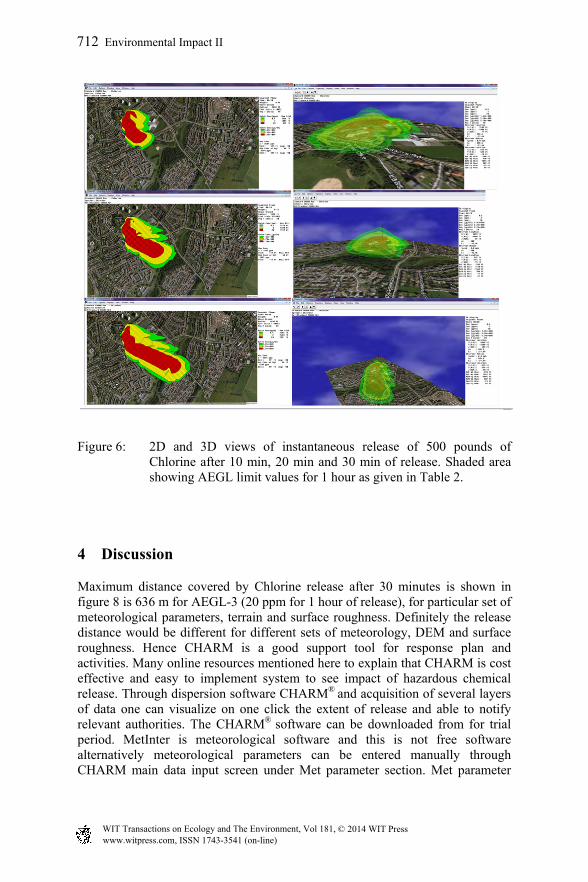
Figure 6: 2D and 3D views of instantaneous release of 500 pounds of Chlorine after 10 min, 20 min and 30 min of release. Shaded area showing AEGL limit values for 1 hour as given in Table 2.
4 Discussion
Maximum distance covered by Chlorine release after 30 minutes is shown in figure 8 is 636 m for AEGL-3 (20 ppm for 1 hour of release), for particular set of meteorological parameters, terrain and surface roughness. Definitely the release distance would be different for different sets of meteorology, DEM and surface roughness. Hence CHARM is a good support tool for response plan and activities. Many online resources mentioned here to explain that CHARM is cost effective and easy to implement system to see impact of hazardous chemical release. Through dispersion software CHARM® and acquisition of several layers of data one can visualize on one click the extent of release and able to notify relevant authorities. The CHARM® software can be downloaded from for trial period. MetInter is meteorological software and this is not free software alternatively meteorological parameters can be entered manually through CHARM main data input screen under Met parameter section. Met parameter
712 Environmental Impact II
www.witpress.com, ISSN 1743-3541 (on-line) WIT Transactions on Ecology and The Environment, Vol 181, © 2014 WIT Press
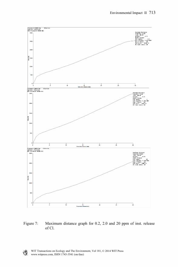
Figure 7: Maximum distance graph for 0.2, 2.0 and 20 ppm of inst. release of Cl.
Environmental Impact II 713
www.witpress.com, ISSN 1743-3541 (on-line) WIT Transactions on Ecology and The Environment, Vol 181, © 2014 WIT Press
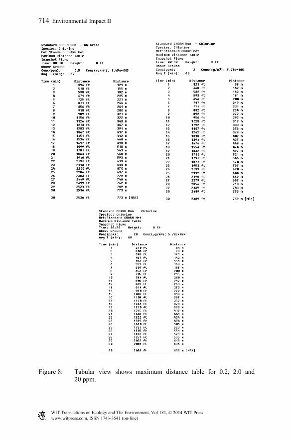
Figure 8: Tabular view shows maximum distance table for 0.2, 2.0 and 20 ppm.
714 Environmental Impact II
www.witpress.com, ISSN 1743-3541 (on-line) WIT Transactions on Ecology and The Environment, Vol 181, © 2014 WIT Press
once entered can be saved and recalled. Average met. Parameters for a day or a month round a year can be noted down from any meteorological website. Climatic data (30 years averages) monthly averages can also be used for approximation as most of the time average values could be used as projected weather except in those days when weather behaves abruptly. If meteorological parameters keep changing then it is better to get real-time data to see the dispersion effect with changing weather conditions. For this purpose Meteorological data from NWS (National Weather Service) can be imported directly into CHARM through software MetInter (meteorological interface). This data update on hourly basis and update the plume consequently. The CHARM
comes up with required parameters of 200+ chemicals of industrial use. DEM of 30m was downloaded from Aster GDEM website. Also downloaded 1km surface roughness data GLCC (Global Land Coverage Classification) from GLCC website. Satellite images served as backdrop were downloaded through Google Earth® or through CHARMInetMaps. CHARMInetMaps is provided by CHARM Inc. Google Earth® images are readily available for use without cost for such scholarly and not for profit purposes (including educational activities or scholarly publication) through the ‘fair use’ clause of the Google permission guidelines, provided that appropriate attribution is given by reprinting the copyright attribution text and Google logo [12]. Another consideration is that Google Earth imagery is not updated in real-time and the imagery may or may not represent all physical features and construction if done after the date mentioned within Google Earth imagery. The geo-referencing of images is required which can be done through ArcGIS or Erdas Imagine. CHARMInetMaps is free software and can be downloaded from CHARM website to get imageries of any area of interest. The software has an option to get imageries from any of the resources like Google, Bing and Yahoo. The other benefit is that these imageries are already geo-referenced for CHARM and no need to geo-reference them. The maps with dispersion pattern provide reality picture and minute information for refuge operations, disaster management authorities and planners to intervene the situation with cost effective and efficient manner. The final product i.e. maps showing dispersion pattern can be export in the format compatible of Google Earth so that viewer can view visual impact of scenario on Google Earth. It is noted that both 2D and 3D of impact can be saved in CHARM so that viewer can visualize both type of impacts.
Acknowledgements
The author acknowledges Dr. Rakhshanda Bilal, DDG BRC; without her support this work would not have been materialized. Dr. Mark W. Eltgroth from CHARM® software division is a reviewer of this paper and his valuable comments and corrections have brought this paper to this form.
Environmental Impact II 715
www.witpress.com, ISSN 1743-3541 (on-line) WIT Transactions on Ecology and The Environment, Vol 181, © 2014 WIT Press
References
[1] CHARM – Software, when realism counts, www.charmmodel.com [2] Future Toolbox models, http://www.orise.orau.gov/emi/scapa/modeling-
toolbox/future-toolbox-models.htm [3] Featured products CHARM, http://www.charmmodel.com/index.aspx [4] ASTER GDEM, http://gdem.ersdac.jspacesystems.or.jp/search.jsp [5] 3D building, http://sketchup.google.com/3dwarehouse/?hl=en&ct=lc [6] Google Building maker, http://sketchup.google.com/3dwarehouse
/buildingmaker [7] Surface Roughness, CHARM application help [8] GLCC website, http://edc2.usgs.gov/glcc/globdoc2_0.php#dataform. [9] Surface Roughness, CHARM application help [10] Internet Weather Source, http://weather.noaa.gov/ [11] AEGLs levels, http://www.epa.gov/opptintr/aegl/pubs/results56.htm [12] Google Maps/Earth Additional Terms of Service, http://www.google.com
/intl/en-US/help/terms_maps.html
716 Environmental Impact II
www.witpress.com, ISSN 1743-3541 (on-line) WIT Transactions on Ecology and The Environment, Vol 181, © 2014 WIT Press