Embed Size (px)
Citation preview

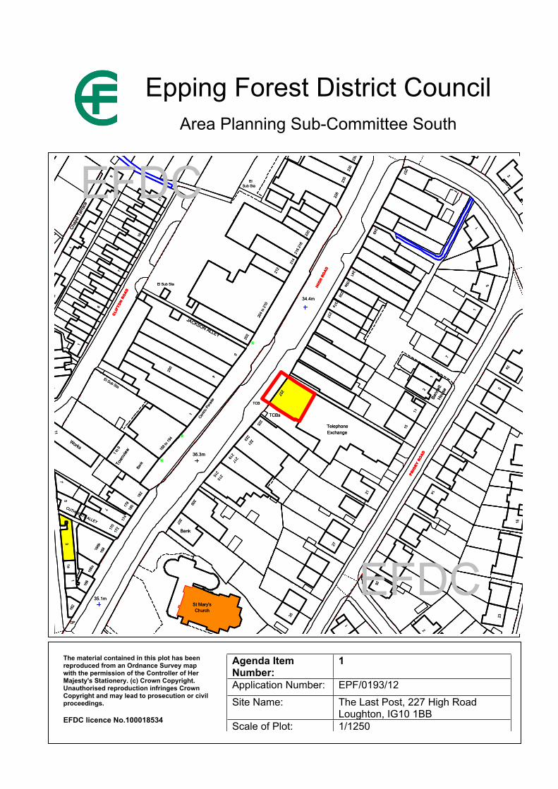
Report Item No: 1
APPLICATION No: EPF/0193/12
SITE ADDRESS: The Last Post227 High RoadLoughtonIG10 1BB
PARISH: Loughton
WARD: Loughton St Marys
APPLICANT: J D Wetherspoon PLC
DESCRIPTION OF PROPOSAL: Change of use of section of pavement to front of pub to provide external eating and drinking area, to be open between 9 am and 8pm Monday to Sunday.
RECOMMENDED DECISION: Grant Permission - (With Conditions) Time Limited Use
Click on the link below to view related plans and documents for this case:http://planpub.eppingforestdc.gov.uk/AniteIM.websearch/ExternalEntryPoint.aspx?SEARCH_TYPE=1&DOC_CLASS_CODE=PL&FOLDER1_REF=534775
CONDITIONS
1 The use hereby permitted shall cease on or before the expiry of one year from the date of this temporary approval.
2 The size of the outdoor seating area hereby approved shall not exceed the dimensions indicated on plan number 6775/03 Rev B hereby approved, and the 1.1m high barrier system shown on the plan shall be erected and retained at all times when the seating area is available for use.
3 The outside seating area shall be only available for use between the hours of 9am to 8pm, and this area shall be kept clear of all furniture, including the barrier system approved, between the hours of 8.30pm and 8.30am the following day.
This application is before this Committee since the recommendation is for approval contrary to an objection from a local council which is material to the planning merits of the proposal - (pursuant to the ‘constitution, part three: planning directorate – delegation of council function, schedule 1,appendix A. (g)
Description of Site:
The Last Post is a pub and restaurant on the east side of the High Road. The depth of pavement outside the pub, and neighbouring shops at numbers 225 and 229, is wider than along other sections of the High, having a depth of 7m, although a small part of this depth is taken up by a ramped pedestrian access into the pub.
Description of Proposal:
Change of use of part of pavement at front of the public house to provide an external seating area for eating and drinking, to be open between 9am and 8pm.
Relevant History:
None.
Policies Applied:
DBE9 – Loss of amenity. ST4 – Road safety. TC3 –Town centre function.
Summary of Representations:
LOUGHTON TOWN COUNCIL – object – the proposed change of County Council land from highway pavement to use of the area for eating, drinking, and smoking was seen by members as undesirable, owing to its position close to a pedestrian crossing on grounds of highway safety. There was no evidence the applicants had or could secure a licence for the intended use. The proposal was also grossly detrimental to nearby residents and pedestrians, who would be subjected to noise and nuisance.
LOUGHTON RESIDENTS ASSOCIATION PLANS GROUP– We object to a permanent grant of permission but would be happy for the Council to give a one year consent so it can be reviewed in the light of a 12 month trial, provided that 1) officers confirm that sufficient width of pavement has been left for pedestrians (including wheelchairs and prams and buggies), and 2) the Council adds a condition requiring the space used to be cleared of all furniture etc at 8pm in the evening and left clean. Also we consider that a permanent consent would be at variance with highway regulations because it would be effectively stopping up the highway and permanently handing the land to the pub.
ESSEX CC HIGHWAYS DEPARTMENT – The Highway Authority has no objections to this proposal subject to it being implemented as shown on drawing no.6775/03 Rev A so as to ensure it is not contrary to the Highway Authority’s development management policies, adopted as County Council Supplementary Guidance in February 2011, and policy ST4 of the Local Plan. The County Council add that the retained width of footway is acceptable as it averages over 3m in width, apart from the pinch point with the litter bin, which is still 2.5m wide.
TONY ELLIS CRIME REDUCTION OFFICER, EPPING FOREST POLICE DISTRICT POLICE, AND EFDC SAFER COMMUNITIES OFFICER – I attended the Last Post with your Safer Communities Officer, Mr. Paul Gardener. Although I appreciate you will review the application purely from a planning perspective, our approach was to carry out a more comprehensive crime and disorder survey encompassing all aspects of crime reduction, as follows. 1) After watching pedestrian traffic for some time we concluded that the narrowing of the pavement would not cause any unnecessary restrictions to the regular movement of pedestrians passing but we recommend that a wooden timber bin be relocated to facilitate the movement of people with pushchairs and prams etc. 2) We spoke to the pub manager and she agreed that the current outside CCTV images are poor, and also that the in house monitor cannot be viewed by staff when they are at work at the bar. We recommend that the current camera be replaced with a more efficient one, and that images are relayed to a monitor in the bar area that can be viewed by staff. 3) The pub manager has met the local residents’ association, who had no objections in principle to the new area. However concerns were raised that if seating was left out and occupied by customers late at night noise and nuisance could be caused. We also pointed out that insecure tables and chairs

could be subject of theft or used as weapons. We recommend therefore that a condition be imposed that all street furniture be removed at least half an hour before the pub closes so as to avoid people remaining in the drinking and eating area after the premises have closed. 4) The manager agreed to our ‘condition’ that unbreakable drinks vessels should be served to customers using this outside area. In conclusion our survey suggests that this proposed new drinking and eating area has no obvious connotations for an increase of crime and disorder in the area. However, as all the furniture are mobile structures, perhaps you would consider issuing a temporary consent to the application on the understanding that that we will review the situation after an agreed period to ensure that the proposed new area has not created any additional problems. NEIGHBOURS – 17 properties consulted, including 6 in Priory Road to the rear, and no replies received.
Issues and Considerations:
Background and revisions to the application
Planning permission is required for this change of use proposal because all the pavement outside of this public house is part of the public highway and in the control of the County Council. This contrasts with some other front seating areas in the High Road where front forecourts are owned by the adjoining café/restaurants - and hence no change of use requiring planning permission is involved. At first sight these privately owned forecourts often appear to be part of the ‘public’ pavement, but they are normally identified by dividing lines or a different surface finish.
Since being lodged this application has been amended. Following a meeting between the pub manager and the Loughton Residents Association Plans Group the time for this outdoor seating to remain has been reduced from 11pm to 8pm. This earlier closing time will reduce the potential for noise and nuisance to be created, and this change deals with one of the concerns raised by the Town Council. Secondly, the applicants are willing to accept a one year temporary planning consent following views made by the LRA and the Police. This will allow a review of any problems caused before a longer period of approval is considered. Thirdly, the applicants have reduced the depth of the outside area and hence a further 0.25m strip of pavement will be retained.
Pedestrian and visual amenity
As mentioned above both the Highway Authority and the Police consider that the remaining average 3m depth of pavement that will be left is satisfactory, and the reduction of the depth of the seating area by a further 0.25m will improve the pinch point of 2.5m pavement width where the waste bin is located. The proposal therefore will not unduly restrict the movement of pedestrians in this key shopping frontage.
The application proposes to house tables and chairs within a 1.1m high barrier system which will contain a coloured canvass surround. These surrounds improve the appearance of these outdoor seating areas, and also prevent tables and chairs from being moved into the adjoining pavement area. More generally it is acknowledged that opinions on these outside seating areas can be polarised, but on balance they can provide more visual interest along a high street location, and can make shopping centres more attractive to visitors.
Other issues and concerns of the Town Council
Although not strictly a planning issue the applicants have agreed to install a new CCTV camera to survey this front area, together with a new monitor which will be viewed from behind the bar. This equipment has been ordered and it will assist in the deterrence and reduction of possible anti-social behaviour. The Town Council are concerned that use of this outdoor area for eating and
drinking would compromise highway safety given the proximity of a pedestrian crossing on the High Road. However, there are sections of safety railing that run next to the roadside kerb, and this concern about a safety hazard is not shared.
Conclusions
The applicants are agreeable to a 12 month temporary planning permission. This would make it possible for revisions to be made to the proposal in 12 months time if problems are encountered. In the unlikely event that severe problems occur then permission could be refused in 12 months time. For these reasons, and those outlined above, it is recommended that a conditional and temporary one year permission be granted.
Should you wish to discuss the contents of this report item please use the following contact details by 2pm on the day of the meeting at the latest:
Planning Application Case Officer: David BakerDirect Line Telephone Number: 01992 564514
or if no direct contact can be made please email: [email protected]
123
33.2m33.2m
34.4m
36.3m
34.7m
35.1m
33.8m
36.3m
34.7m
35.1m
34.4m
33.8m
CR
ED & W
ard Bdy
CR
ED & W
ard Bdy
2a
5
2
1
7
261265 263
1
23 2
4
1 2
21 2
2
2
7
1
214
237a
216
218
239a
241
239
220
249
212
230
230
230
228
257
El
21
232
Sub Sta
4
237
202
6
204
to 2
10
200
6
11
16
6
25
El Sub Sta
23
21
1
33 31 29 27
Chap
el Te
rrace
1
265 263
23 2
4
261
1 2
21 2
2
9
2a
97
23
15
23
15
Benn
ett
7
1
11
Hous
e
15
1
Telephone
225
227
Telephone
225
237a
216
218
239a
237
202
241
239
212
204
to 2
10
209
1
35
Bank
Church
209
1
2154
223
219
221
217
Centric
Par
ade
223
219
230
230
228
5
230
257
249
232
2
1
2
1
2
2
Exchange
2227
Benn
ett
11
Hous
e
15
Exchange
2
2626
14
27
21
14
27
21
El
6
220
214
Sub Sta
ChurchSt Mary's
35
St Mary's
188 t
o 194
213
221
217
213215
1
Bank
Centric
Par
ade
182
178
180
207207
Bank172
7
174
172
7
174
170
1 to 9
Town
view
25
Chap
el Te
rrace
11
21
16
21
6
8
Sub StaEl
162
168
168
1a
166a
1
166
166a
1
166
1220 3
1311
Works
7
1 to 9 18
8 to 1
9420
0
BankTo
wnvie
w
182
178
180
El Sub Sta
23
33 31 29 27
6
1
1
1a
166b
12
170
162
3
8
166b
5
11
Works
7
13
5
20
Sub StaEl
BR
OO
KLY
N A
VE
NU
E
PRIO
RY R
OAD
CHURCHFIELDS
BR
OO
KLY
N A
VE
NU
E
PRIO
RY R
OAD
CHURCHFIELDS
CLIF
TON
RO
AD
HIG
H R
OAD
HIG
H R
OAD
CLIF
TON
RO
AD
JACKSON ALLEY
El Sub Sta
Post
El Sub Sta
Post
TCBs
GP
PC
TCB
TCBs
TCB
JACKSON ALLEY
GP
CUTHBERTS ALLEY
PC
CUTHBERTS ALLEY
*
*
*
EFDC
EFDC
Epping Forest District CouncilArea Planning Sub-Committee South
The material contained in this plot has been reproduced from an Ordnance Survey map with the permission of the Controller of Her Majesty's Stationery. (c) Crown Copyright. Unauthorised reproduction infringes Crown Copyright and may lead to prosecution or civil proceedings.
EFDC licence No.100018534
Agenda Item Number:
1
Application Number: EPF/0193/12Site Name: The Last Post, 227 High Road
Loughton, IG10 1BBScale of Plot: 1/1250
Report Item No: 2
APPLICATION No: EPF/0323/12
SITE ADDRESS: Sports Pavilion Langston Road LoughtonEssexIG10 3TQ
PARISH: Loughton
WARD: Loughton Broadway
APPLICANT: Mr Christopher Hunn
DESCRIPTION OF PROPOSAL: Change of use of existing office to the front of the Sport Academy at Langston Road, for use as an Operating Centre for Private Hire and Hackney Carriage work.
RECOMMENDED DECISION: Grant Permission (With Conditions)
Click on the link below to view related plans and documents for this case:http://planpub.eppingforestdc.gov.uk/AniteIM.websearch/ExternalEntryPoint.aspx?SEARCH_TYPE=1&DOC_CLASS_CODE=PL&FOLDER1_REF=535195
CONDITIONS
1 The development hereby permitted must be begun not later than the expiration of three years beginning with the date of this notice.
This application is before this Committee since the recommendation is for approval contrary to an objection from a local council which is material to the planning merits of the proposal - (pursuant to the ‘constitution, part three: planning directorate – delegation of council function, schedule 1,appendix A. (g)
Description of Site:
The application premises is an existing small office of 15 sq.m. It is located within the Sports Academy building which is a substantial single storey building with sections of it being two stories. The building has a large curtilage comprising of a variety of sports pitches, particularly football, and a large car park lies adjacent to the building. The building is used to manage sports and leisure uses on the site, and it is also used for a variety of social functions. Although the site lies adjoining the large Langston Road employment area, the site itself lies in the Green Belt.
Description of Proposal:
Change of use of existing office at the front of the Sports Academy building to an operating centre for private hire and hackney carriage work.
Relevant History:
None.
Policies Applied:
DBE9 – Loss of amenity. ST4 – Road safety. GB2A –Development in the Green Belt.GB8A – Change of use or adaption of buildings.
Summary of Representations:
LOUGHTON TOWN COUNCIL – object to this change of use since the use is an unsuitable one to be sited on Green Belt land contrary to policy GB2A. LOUGHTON RESIDENTS ASSOCIATION PLANS GROUP– object on same grounds as the Town Council above.
NEIGHBOURS – one property consulted, and site notice erected, and no replies received.
Issues and Considerations:
A lot of the business of the proposed car hire use will be generated by people visiting and using this academy, which is a busy sports and leisure complex but is not served by any bus routes. Given that the use will be inside the existing building the proposal does not result in any built development and hence there will no loss of openness in the Green Belt. In addition the use is an appropriate one since it provides a useful service to what is in part an open sports facility located in the Green Belt. For these reasons the concerns of the Town Council and LRA Plans Group are not shared.
The proposal will provide employment for 3 people. The site has a large car park and turning area, and consequently the proposed use will not give rise to parking or highway safety problems along Langston Road. Use of this vehicle hire office late at night would not give rise to amenity issues since the locality is a commercial one in which there are no dwellings.
Conclusions
For the reasons outlined above this is a minor and acceptable change of use, and conditional planning permission is therefore recommended. Should you wish to discuss the contents of this report item please use the following contact details by 2pm on the day of the meeting at the latest:
Planning Application Case Officer: David BakerDirect Line Telephone Number: 01992 564514
or if no direct contact can be made please email: [email protected]
123
Pavilion
Football Centre
The Academy
Football Centre
Pavilion
The Academy
Path
Tennis Courts
Sports Ground
Tennis Courts
Path
Sports Ground
EFDC
EFDC
Epping Forest District CouncilArea Planning Sub-Committee South
The material contained in this plot has been reproduced from an Ordnance Survey map with the permission of the Controller of Her Majesty's Stationery. (c) Crown Copyright. Unauthorised reproduction infringes Crown Copyright and may lead to prosecution or civil proceedings.
EFDC licence No.100018534
Agenda Item Number:
2
Application Number: EPF/0323/12Site Name: Sports Pavilion, Langston Road
Loughton, IG10 3TQScale of Plot: 1/1250
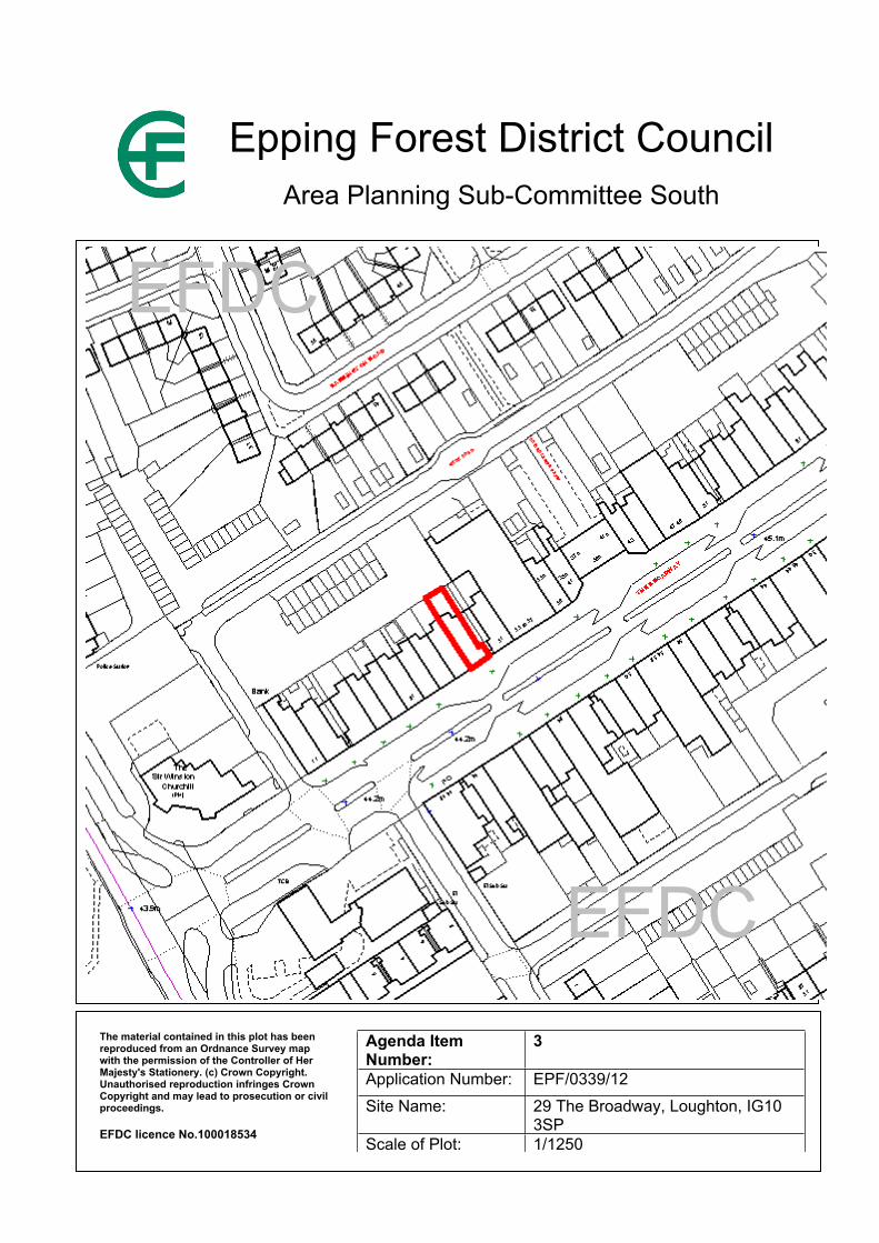
Report Item No: 3
APPLICATION No: EPF/0339/12
SITE ADDRESS: 29 The BroadwayLoughtonEssexIG10 3SP
PARISH: Loughton
WARD: Loughton Broadway
APPLICANT: Instant Cash Loans Ltd
DESCRIPTION OF PROPOSAL: Change of use from A1 Retail to A2 Financial and Professional Services.
RECOMMENDED DECISION: Grant Permission (with conditions)
Click on the link below to view related plans and documents for this case:http://planpub.eppingforestdc.gov.uk/AniteIM.websearch/ExternalEntryPoint.aspx?SEARCH_TYPE=1&DOC_CLASS_CODE=PL&FOLDER1_REF=535244
CONDITIONS
1 The development hereby permitted must be begun not later than the expiration of three years beginning with the date of this notice.
This application is before this Committee since the recommendation is for approval contrary to an objection from a local council which is material to the planning merits of the proposal (Pursuant to The Constitution, Part Three: Planning Directorate – Delegation of Council function, Schedule 1, Appendix A.(g))
Additional Information:
The application was deferred from the Area Plans Sub Committee South meeting dated 25th April 2012 in order for Officers to reassess the proposal in the context of up to date information about the balance of retail and non-retail uses in the Broadway and the extent of vacant shops.
A further Town Centre Survey was undertaken by Planning Services in May 2012. The latest figures that this survey shows is that the current balance of retail and non-retail uses within the key frontage (which is the only part of the town centre subject to the calculations as laid out in Local Plan policy TC4) are:
Current retail = 84.1%Current non-retail = 15.9%
As can be seen, the balance of retail and non-retail units has not changed from that quoted within the original Committee Report (reproduced in full below), as these figures do not take into account vacancies, as they simply relate to the lawful use class of each unit. Therefore the proposed change of use would still only result in an 18% non-retail frontage within the key frontage of The
Broadway, which is well within the 30% tolerance allowed by policy TC4. Whilst it may be considered that the 30% figure quoted in TC4 is too high, such issues cannot be considered in applications such as this but must be raised when adopting or reviewing Local Plan policies.
This latest survey does however reveal a more up to date vacancy rate than the November 2011 survey did. The latest survey shows that there are no vacant units within the key frontage, and just one vacant non-retail (A2) unit within the non-key frontage area (specifically No. 16 Torrington Drive, previously occupied by William Hill). This therefore changes the previously quoted vacancy figure of 13.6% to just 2.8%. Whilst this is quite a dramatic difference, vacancy rates do not form part of the policy requirement of TC4 and therefore this issue does not alter the compliance of the scheme with adopted Local Plan policies.
The latest Town Centre Survey has not altered the recommendation to approve the application, as this proposal still complies with the relevant Local Plan policies, despite the lower vacancy rate within The Broadway.
ORIGINAL REPORT
Description of Proposal:
Consent is being sought for the change of use from A1 Retail to A2 Financial and Professional Services.
Description of Site:
The application site is a vacant unit located within the key frontage of The Broadway. The unit has a frontage width of some 7m and was last used as a Pawnbrokers.
Relevant History:
EPF/1663/05 - Change of use from Class A1 retail to Class A2 bookmakers and external alterations to include new front – refused 14/11/05
Policies Applied:
TC1 – Town centre hierarchyTC3 – Town centre functionTC4 – Non-retail frontage
Consultation Carried Out and Summary of Representations Received:
13 neighbours were consulted. No Site Notice was required.
TOWN COUNCIL – Object to the loss of an A1 premises in a key frontage locality that would be detrimental to the viability and vitality of the Broadway town centre.
LOUGHTON RESIDENTS ASSOCIATION (Plans Group) – Object as this would reduce the vitality and viability of The Broadway as a shopping area and because no effort appears to have been made to market the unit for A1 use.
Issues and Considerations:
The main consideration is the impact on the vitality and viability of the town centre. Local Plan policy TC4 allows for non-retail units within the key frontage of town centres provided it would not result in:
(i) Non-retail frontage exceeding 30%; and(ii) More than two adjacent non-retail uses, regardless of shop frontage width.
In 2005 planning permission was refused for the change of use of this unit to A2 for the following reason:
The proposal would result in more than 20% of non-retail units in the primary shopping frontage of the Broadway. Loughton and would harm the vitality and viability of the shopping centre and would therefore by contrary to policy STC7 of the adopted Local Plan.
Since this time the Local Plan Alterations have been adopted (TC4 has replaced STC7), which altered the percentage of non-retail frontage permitted from 20% to 30%.
The latest Town Centre Survey undertaken by Planning Services (November 2011) shows that there is just 15.9% non-retail frontage within The Broadway’s Key Frontage. As such the proposed change of use would increase this to 18%, which is still within the acceptable tolerance as stated within policy TC4 (i).
With regards to TC4 (ii), whilst the adjacent unit to the northeast is a nail studio (S/G) the unit beyond this and that adjoining the application site to the southwest are A1 retail shops. As such, the proposed change of use would not result in more than two adjacent non-retail units.
The Loughton Residents Association (Plans Group) have objected as no evidence has been submitted showing that the unit has been marketed for A1 use, however the Local Plan policy does not require this and therefore this would not constitute a reason for refusal.
Further to the above, The Broadway town centre has a higher than average vacancy rate (13.6%) than the national average (11.9%). Given the recent push within the National Planning Policy Framework for Local Planning Authorities to assist economic development and growth, the use of a unit within a town centre (provided it is a use suited to such areas) would be preferable and far more beneficial to the vitality and viability of the town centre than a vacant unit with a ‘dead frontage’.
Conclusion:
The proposed change of use complies with the requirements as set out in Local Plan policy TC4 and as such would not be detrimental to the vitality and viability of the town centre. Furthermore, the use of this unit for a suitable town centre purpose would be more beneficial to the surrounding area than a ‘dead fronted’ vacant unit. As such, the proposed change of use complies with the relevant Local Plan policies and is therefore recommended for approval.
Should you wish to discuss the contents of this report item please use the following contact details by 2pm on the day of the meeting at the latest:
Planning Application Case Officer: Graham CourtneyDirect Line Telephone Number: 01992 564228
or if no direct contact can be made please email: [email protected]
123
EFDC
EFDC
Epping Forest District CouncilArea Planning Sub-Committee South
The material contained in this plot has been reproduced from an Ordnance Survey map with the permission of the Controller of Her Majesty's Stationery. (c) Crown Copyright. Unauthorised reproduction infringes Crown Copyright and may lead to prosecution or civil proceedings.
EFDC licence No.100018534
Agenda Item Number:
3
Application Number: EPF/0339/12Site Name: 29 The Broadway, Loughton, IG10
3SPScale of Plot: 1/1250
Report Item No: 4
APPLICATION No: EPF/0444/12
SITE ADDRESS: 84 & 86 England's LaneLoughtonEssexIG10 2QQ
PARISH: Loughton
WARD: Loughton St Johns
APPLICANT: Mr Paul Cockram
DESCRIPTION OF PROPOSAL: Loft extension to adjoining properties.
RECOMMENDED DECISION: Grant Permission (Subject to Legal Agreement)
Click on the link below to view related plans and documents for this case:http://planpub.eppingforestdc.gov.uk/AniteIM.websearch/ExternalEntryPoint.aspx?SEARCH_TYPE=1&DOC_CLASS_CODE=PL&FOLDER1_REF=535655
CONDITIONS
1 The development hereby permitted must be begun not later than the expiration of three years beginning with the date of this notice.
2 The works hereby approved to 84 and 86 Englands Lane shall be carried simultaneously. Should works to one house be commenced more than 14 days prior to works starting at the neighbouring attached house, those works shall cease and not recommence until works to the attached house have also been commenced. No work to form the dormer windows hereby approved shall be commenced until the ridge of both houses has been raised and roof slopes formed to the height and pitch shown on the approved plans.
3 The development hereby permitted will be completed strictly in accordance with the approved drawing numbers 1 -7 as numbered by the Local Planning Authority.
4 No construction works above ground level shall have taken place until documentary and photographic details of the types and colours of the external finishes have been submitted to and approved by the Local Planning Authority, in writing, prior to the commencement of the development. The development shall be implemented in accordance with such approved details.
Subject to the completion, within 6 months of a resolution to grant planning permission, an agreement under section 106 of the Town and Country Planning Act 1990 requiring the owners of 84 and 86 Englands Lane to carry out the approved works to both houses simultaneously.
This application is before this Committee since the recommendation differs from the views of the local council (Pursuant to Section CL56, Schedule A (g) of the Council’s Delegated Functions).
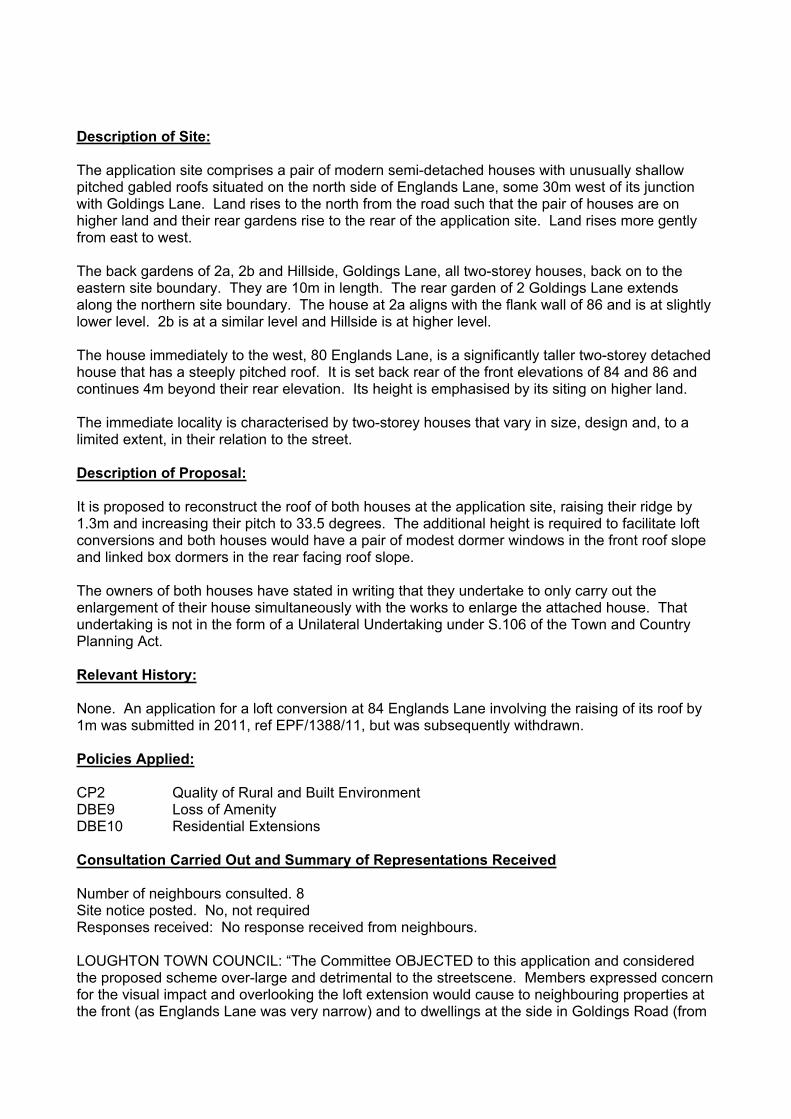
Description of Site:
The application site comprises a pair of modern semi-detached houses with unusually shallow pitched gabled roofs situated on the north side of Englands Lane, some 30m west of its junction with Goldings Lane. Land rises to the north from the road such that the pair of houses are on higher land and their rear gardens rise to the rear of the application site. Land rises more gently from east to west.
The back gardens of 2a, 2b and Hillside, Goldings Lane, all two-storey houses, back on to the eastern site boundary. They are 10m in length. The rear garden of 2 Goldings Lane extends along the northern site boundary. The house at 2a aligns with the flank wall of 86 and is at slightly lower level. 2b is at a similar level and Hillside is at higher level.
The house immediately to the west, 80 Englands Lane, is a significantly taller two-storey detached house that has a steeply pitched roof. It is set back rear of the front elevations of 84 and 86 and continues 4m beyond their rear elevation. Its height is emphasised by its siting on higher land.
The immediate locality is characterised by two-storey houses that vary in size, design and, to a limited extent, in their relation to the street.
Description of Proposal:
It is proposed to reconstruct the roof of both houses at the application site, raising their ridge by 1.3m and increasing their pitch to 33.5 degrees. The additional height is required to facilitate loft conversions and both houses would have a pair of modest dormer windows in the front roof slope and linked box dormers in the rear facing roof slope.
The owners of both houses have stated in writing that they undertake to only carry out the enlargement of their house simultaneously with the works to enlarge the attached house. That undertaking is not in the form of a Unilateral Undertaking under S.106 of the Town and Country Planning Act.
Relevant History:
None. An application for a loft conversion at 84 Englands Lane involving the raising of its roof by 1m was submitted in 2011, ref EPF/1388/11, but was subsequently withdrawn.
Policies Applied:
CP2 Quality of Rural and Built EnvironmentDBE9 Loss of AmenityDBE10 Residential Extensions
Consultation Carried Out and Summary of Representations Received
Number of neighbours consulted. 8Site notice posted. No, not requiredResponses received: No response received from neighbours.
LOUGHTON TOWN COUNCIL: “The Committee OBJECTED to this application and considered the proposed scheme over-large and detrimental to the streetscene. Members expressed concern for the visual impact and overlooking the loft extension would cause to neighbouring properties at the front (as Englands Lane was very narrow) and to dwellings at the side in Goldings Road (from
the two rear Juliet balconies). The proposal was deemed contrary to policies DBE9 (i) and (ii), and DBE10 (i) of Epping Forest District Council’s adopted Local Plan and Alterations.”
Main Issues and Considerations:
Design and Appearance
Having regard to the variety of size and design of house type in the locality, the degree of separation from adjacent houses and since the resulting pitch of the enlarged roof would not be uncommon, the proposal to raise the height of the roof by 1.3m is acceptable in principle.
At the front elevation, the proposed dormer windows would be modest (1.7m wide) and set in substantially from the edges of the roof. They would be set 2m from the edge of the eaves and 1m from the ridge. They would be set 0.75m from the flank elevations and there would be a distance of 1.2m between those at each house, although only 0.5m would separate the centre two dormers. Having regard to their size and spacing the proposed front dormer windows would on balance meet the policy test to complement the appearance of the enlarged roof and, as a whole, the proposal would not cause harm to the street scene.
The rear elevation of the enlarged roof would be dominated by a substantial linked box dormer window set 0.75m from the flank elevations and the edge of the eaves. Each dormer would have a large centrally positioned window enclosed by a Juliette balcony. Although a very dominant feature, its scale and design would be consistent with the style of the original house. The dormer would not generally be visible from the street but it would be clearly visible from the rear of 2a, 2b and Hillside, Goldings Road. Since it would complement the design of this particular pair of houses the proposed rear dormers are acceptable in their context. They would not necessarily be acceptable in the rear elevation of houses of a different design.
The main risk posed by the proposal is if the development was only implemented at one of the pair of semi detached houses. That would give the pair an extremely unbalanced appearance that would be harmful to the character and appearance of the locality. Since the potential harm would be so serious it is only possible to effectively resolve this matter by requiring the owners of both 84 and 86 Englands Lane to enter into a S106 agreement requiring the development to be carried out at the same time. Given the written undertaking already given by them there should be no difficulty in securing that. As an additional safeguard, it is also recommended that a planning condition duplicating the effect of the S106 agreement is included on any consent given, although that is not strictly necessary in those circumstances.
Impact on living conditions
Due to its size and the relationship to neighbouring properties (set out in the site description section of this report) the proposal would not appear overbearing or cause any loss of light. Its visual impact would be acceptable.
Loughton Town Council is particularly concerned about the potential for the proposal to give rise to excessive overlooking of neighbouring properties. Overlooking of properties across public areas such as a street is not normally expected to give rise to any loss of privacy but this is one of the concerns raised. The potential for such overlooking arises from the proposed front dormer windows. Since they are set rear of the front elevation they are further away from properties on the opposite side of Englands Lane than the existing front elevation windows. Furthermore, they are modest in size and a minimum distance of 21m would separate the dormers from the front elevation of houses opposite the site. In the circumstances there is no potential for the front dormer windows to give rise to any excessive overlooking.
Notwithstanding the size of windows in the proposed rear dormers, it would not be possible to overlook any part of the rear elevations of 2a Goldings Road from them and any views of the rear of 2b would be within a highly restricted angle. There would be somewhat less oblique views of Hillside from the dormer proposed at 86 Englands Lane that would primarily take in the rear garden area of that house. However, the rear elevation of the house is at least 21m from the position of the window in the proposed dormer and most of the potentially visible part of the rear garden is at least 16m away and set off to the east. Views would be somewhat more than from existing first floor windows in the rear elevation of that house but would be obscured by trees in the rear garden of Hillside. As a consequence, the proposed rear dormers would not give rise to an excessive degree of overlooking.
Overall, the proposal would safeguard the living conditions of neighbouring properties and while the matters raised by the Town Council warrant careful consideration, the above analysis of the proposal demonstrates no excessive harm would be caused.
Conclusion:
The proposal would complement the appearance of this particular pair of houses and consequently would appear appropriate in the street scene. Moreover, given the relationship with neighbouring properties their living conditions would not be harmed by the proposal. In the circumstances the proposal complies with relevant policies listed above and it is recommended that planning permission be granted following the completion of an appropriate planning obligation.
Should you wish to discuss the contents of this report item please use the following contact details by 2pm on the day of the meeting at the latest:
Planning Application Case Officer: Stephan SolonDirect Line Telephone Number: 01992 564018
or if no direct contact can be made please email: [email protected]

123
UndUndFW
CW
FW
CWFW
CW
FW
CW
CFCF
FWCW
FWCF
FW
CF
CFCF
CW
FW
113 131 131c131a
129
96
119
25
El Sub Sta2c
to 2
e
2
1111a
9a
13a
13
16
9
15
1
14
100
131b
127
15
5
79
1
2
73a
55a
210
7a
Hillside
2b 1a3
86
1
84
105
2a80
9793
35
14
Long
field
Cot
tage
s
75
57
45
85
66
77
76
62
3840
6955
50
5
6153
6757
18
1
71
11
Ree
Lan
e C
otta
ges
7
59
1830
57
42
4737 27
131c
2
14
1
96
100
131b131 131a
129127
15
5
97
1
2
2
55a
10
77a
El Sub Sta
35
10597
113119
25
9a11
11a
13a
13
16
9
15
1
2b 1a3a
3
Hillside
8684
2a
57
1440
38
59
45
93
85
66
77
75
76
80
30 18
4737 27
50
55
5
6153
67
62
6957
Long
field
Cot
tage
s
71
11
Ree
Lan
e C
otta
ges1
7
18
57
42
HILLCROFT
HILLCROFT
COLES GREEN
GOLDINGS ROAD
COLES GREEN
ENGLANDS LANE
GOLDINGS ROAD
ENGLANDS LANE
LBLB
EFDC
EFDC
Epping Forest District CouncilArea Planning Sub-Committee South
The material contained in this plot has been reproduced from an Ordnance Survey map with the permission of the Controller of Her Majesty's Stationery. (c) Crown Copyright. Unauthorised reproduction infringes Crown Copyright and may lead to prosecution or civil proceedings.
EFDC licence No.100018534
Agenda Item Number:
4
Application Number: EPF/0444/12Site Name: 84 & 86 England's Lane, Loughton
IG10 2QQScale of Plot: 1/1250
Report Item No: 5
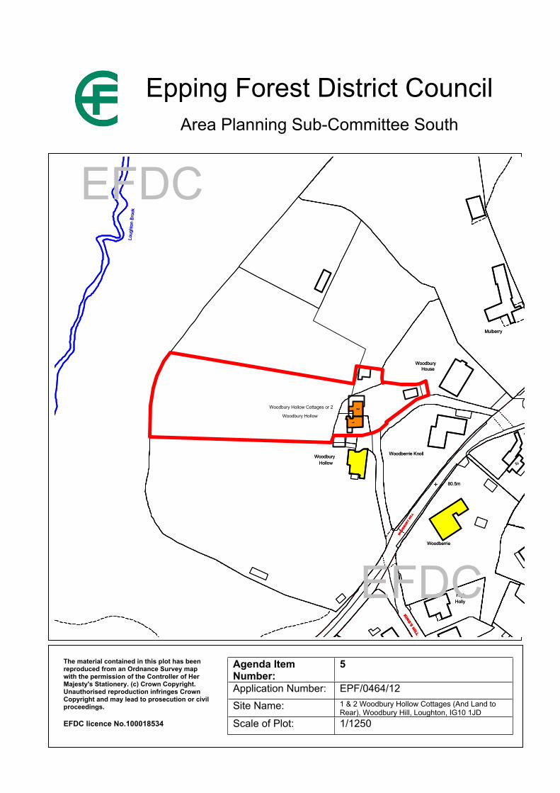
APPLICATION No: EPF/0464/12
SITE ADDRESS: 1 & 2 Woodbury Hollow Cottages (And Land to Rear)Woodbury HillLoughtonEssexIG10 1JD
PARISH: Loughton
WARD: Loughton St Johns
APPLICANT: Mr James Holloway
DESCRIPTION OF PROPOSAL: Change of use of part of land within the site for use as residential garden and retention of shed and greenhouse.
RECOMMENDED DECISION: Grant Permission (With Conditions)
Click on the link below to view related plans and documents for this case:http://planpub.eppingforestdc.gov.uk/AniteIM.websearch/ExternalEntryPoint.aspx?SEARCH_TYPE=1&DOC_CLASS_CODE=PL&FOLDER1_REF=535745
CONDITIONS
1 Notwithstanding the provisions of the Town and Country Planning General Permitted Development Order 1995 as amended (or any other Order revoking, further amending or re-enacting that Order) no development generally permitted by virtue of Class E of Part 1 of Schedule 2 to the Order shall be undertaken within the curtilage of 1 & 2 Woodbury Hollow Cottages without the prior written permission of the Local Planning Authority.
2 Land within the application site west of the land shown hatched on drawing 1139 2 Rev. a shall not be used for residential purposes and shall not be included within the curtilage of 1 & 2 Woodbury Hollow Cottages. Notwithstanding the provisions of the Town and Country Planning General Permitted Development Order 1995 as amended (or any other Order revoking, further amending or re-enacting that Order) no fence, wall or other means of enclosure generally permitted by virtue of Class A of Part 2 of Schedule 2 to the Order shall be erected on the land, other than on its northern, western and southern boundaries with neighbouring land, without the prior written permission of the Local Planning Authority.
This application is before this Committee since the recommendation differs from the views of the local council (Pursuant to Section CL56, Schedule A (g) of the Council’s Delegated Functions).
Description of Site:
Extended Grade II listed detached house, originally a pair of semi-detached houses, within the York Hill Conservation Area and the Green Belt. The site is on land below the level of Woodbury Hill accessed via a single track access road. Land falls away west of the house (the rear) and rises steeply east of its front elevation to a garage in the western corner of the front garden. There
is no usable rear garden and the curtilage of the house is set an average of 4m beyond the rear elevation of the house.
Rear of the house is an open grassed field that continues to Epping Forest, some 90m beyond the curtilage. Trees mark the southern boundary of the field, while its northern boundary is open, enclosed by a low field fence. Beyond the northern boundary is the garden of Woodbury House, which includes a tennis court. Beyond the southern boundary is an open field rear of the back garden of Woodbury Hollow.
Description of Proposal:
This proposal comprises 3 elements:
1. The extension of the western limit to the curtilage of Woodbury Hollow Cottages an average of 19m into the field west of the house. The limit of the new curtilage would be 3m beyond the western flank of a greenhouse erected on the land.
2. Retention of the greenhouse erected on the land proposed to be included in the curtilage of Woodbury Hollow Cottages. The building is a predominantly glazed structure that is of timber construction and is approximately 3m high at the ridge. It is set on the southern site boundary adjacent to well established trees, has a width of 4.2m and a maximum depth of 3.5m.
3. Retention of a timber shed that is situated within the present curtilage of Woodbury Hollow Cottages, some 7m north of the northern flank of the house abutting the site boundary with Woodbury House. The building is of timber construction with a plain tiled gabled roof. Its ridge height is 4.15m, its width 5.2m and depth is a maximum of 4.7m. Its northern and western flanks are enclosed by a substantial laurel hedge.
Relevant History:
EPF/1097/86 Two storey side and single storey rear extensions. ApprovedEPF/0102/07 Alterations to fenestration in previously approved (EPF/1097/86) two storey
side extension and erection of detached garage. ApprovedEPF/2414/11 Detached summer house and detached greenhouse. Refused for the
following reason:“The greenhouse is sited on land which falls outside of the residential boundary of Woodbury Hollow Cottages. Accordingly it is not appropriate to consider the retention of the domestic outbuilding separately to an application for the change of use of the land. No such application has been received and this application is not made in respect of any material change of use of land.”
Policies Applied:
CP2 Quality of Rural and Built EnvironmentGB2A Development in the Green BeltGB4 Extensions of Residential CurtilagesGB7A Conspicuous DevelopmentHC6 Character Appearance and Setting of Conservation AreasHC7 Development Within Conservation AreasHC12 Development Affecting the Setting of Listed BuildingsDBE1 Design of New BuildingsDBE4 Design in the Green BeltDBE9 Loss of Amenity
LL10 Adequacy of Provision for Landscape Retention
Consultation Carried Out and Summary of Representations Received
Number of neighbours consulted. 2Site notice posted. YesResponses received: No response received from neighbours.LOUGHTON TOWN COUNCIL: Objection raised to the principle of the change of use of
Green Belt land that is within a conservation area.CONSERVATORS OF EPPING FOREST: No response received
Main Issues and Considerations:
A previous application to retain the greenhouse was refused solely on the basis the application did not include any proposal to use land within which it is sited as residential curtilage. This application overcomes that defect and it is now possible to consider the proposal as a whole.
The principle of enlarging the curtilage of dwellinghouse in the Green Belt is acceptable in policy terms subject to compliance with the requirements of Local Plan and Alterations Policy GB4. In this case the proposed additional area of curtilage, which would be used as garden for the house, would be in proportion to the size of house it would serve and well related to it. It would also be well related to the curtilage of neighbouring houses, which bound the entire northern boundary and most of the southern boundary of the proposed additional curtilage. Subject to the imposition of planning conditions removing permitted development rights for the erection of out-buildings on the land and prohibiting the use of other land at Woodbury Hollow Cottages in the ownership of the applicant from being used as part of the curtilage of the house, the proposal would not have an adverse impact on the open character of the landscape. The proposal to enlarge the curtilage therefore complies with the requirements of policy GB4 and amounts to appropriate development in the Green Belt.
Due to their sensitive design and siting the retention of the conservatory and shed buildings would not be harmful to the open character of the landscape. Indeed, the shed is well screened from views outside the present curtilage of Woodbury Hollow Cottages. In the circumstances and since they are of a scale that is reasonably related to the main house as ancillary domestic buildings, they are also appropriate development in the Green Belt.
The Council’s Conservation Officer was consulted in respect of the design of the buildings to be retained and their impact on the York Hill Conservation Area and the setting of Woodbury Hollow Cottages as a listed building. The Officer finds the buildings are sensitively designed and consequently is content with their impact on the character and appearance of the Conservation Area and on the setting of the listed building.
The development causes no harm to the amenities enjoyed by the occupants of neighbouring properties and causes no harm to adjacent trees.
Conclusion:
Based on the above assessment of the merits of the proposal it is recommended that planning permission be granted.

Should you wish to discuss the contents of this report item please use the following contact details by 2pm on the day of the meeting at the latest:
Planning Application Case Officer: Stephan SolonDirect Line Telephone Number: 01992 564018
or if no direct contact can be made please email: [email protected]
123
80.5m80.5m
1515
HouseWoodbury
Mulberry
HouseWoodbury
Mulberry
94
Orchard CottageOrchard Cottage
90
942
High
Woodberrie
Holly
2
High
Woodberrie
Holly
Woodberrie Knoll
21
Woodberrie Knoll
21
2525
Little WoodberrieLittle Woodberrie
WoodburyHollow
Woodbury Hollow
Hollow
Woodbury Hollow Cottages or 2
Woodbury
90
WOO
DBUR
Y HI
LL
KING'S HILL
WOO
DBUR
Y HI
LL
KING'S HILL
Loug
hton
Bro
okLo
ught
on B
rook
EFDC
EFDC
Epping Forest District CouncilArea Planning Sub-Committee South
The material contained in this plot has been reproduced from an Ordnance Survey map with the permission of the Controller of Her Majesty's Stationery. (c) Crown Copyright. Unauthorised reproduction infringes Crown Copyright and may lead to prosecution or civil proceedings.
EFDC licence No.100018534
Agenda Item Number:
5
Application Number: EPF/0464/12Site Name: 1 & 2 Woodbury Hollow Cottages (And Land to
Rear), Woodbury Hill, Loughton, IG10 1JDScale of Plot: 1/1250
Report Item No: 6
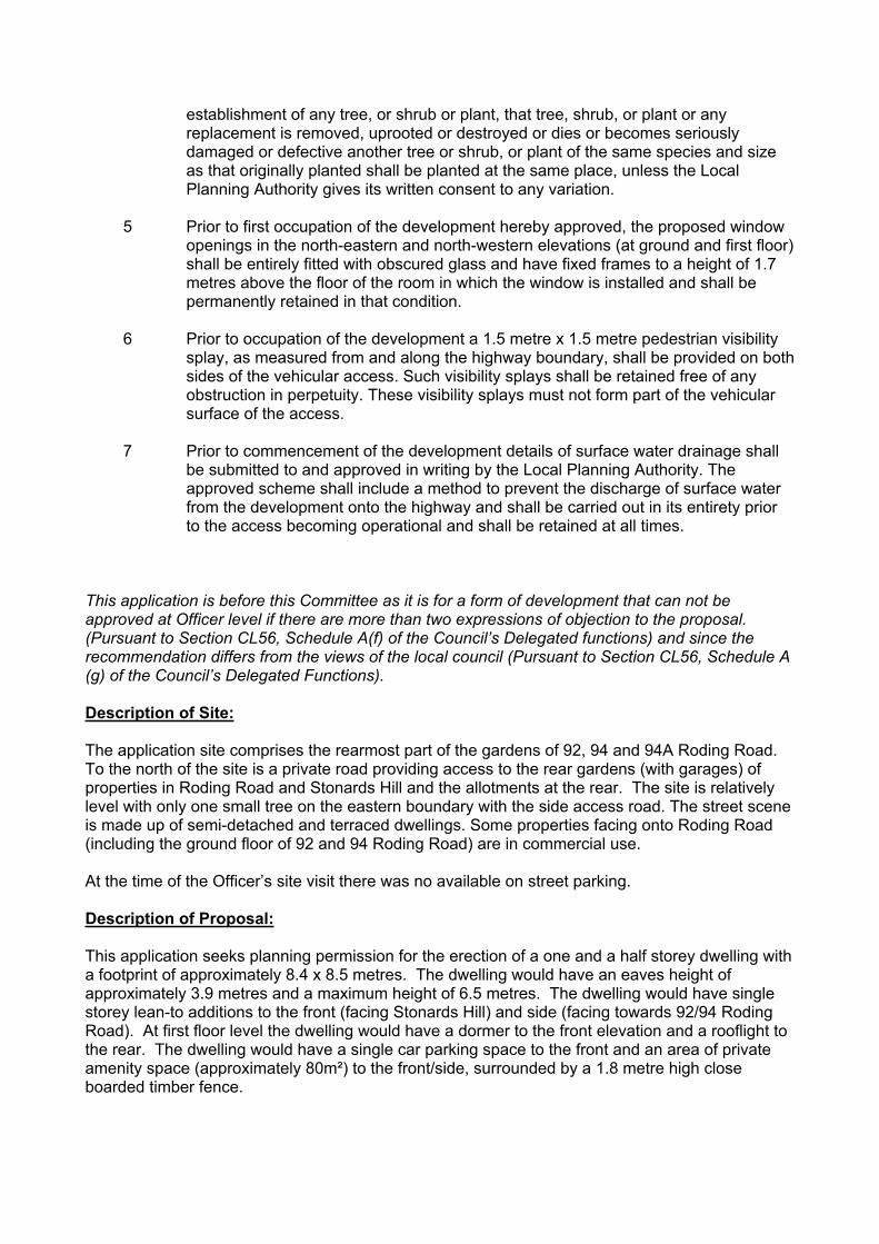
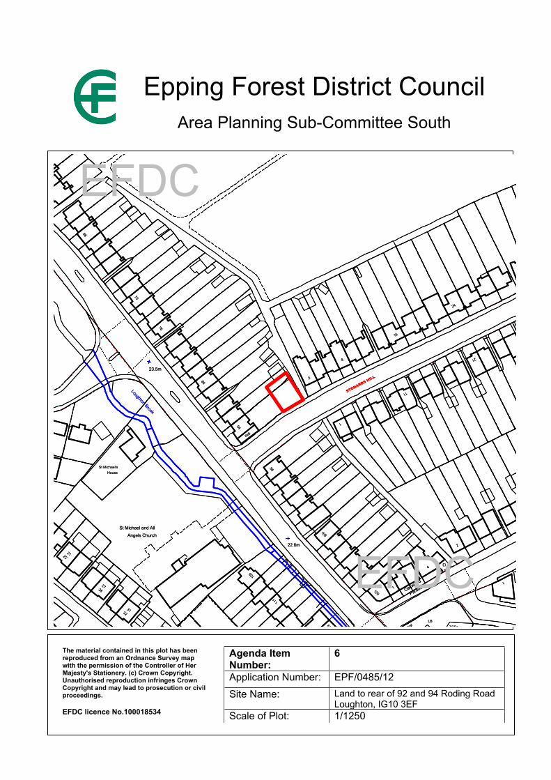
APPLICATION No: EPF/0485/12
SITE ADDRESS: Land to rear of 92 and 94 Roding RoadLoughtonEssexIG10 3EF
PARISH: Loughton
WARD: Loughton Roding
APPLICANT: Mr Narinder Sahota
DESCRIPTION OF PROPOSAL: Erection of two bedroom one and a half storey detached dwelling with one off street car parking space. (Revised Application)
RECOMMENDED DECISION: Grant Permission (With Conditions)
Click on the link below to view related plans and documents for this case:http://planpub.eppingforestdc.gov.uk/AniteIM.websearch/ExternalEntryPoint.aspx?SEARCH_TYPE=1&DOC_CLASS_CODE=PL&FOLDER1_REF=535794
CONDITIONS
1 The development hereby permitted must be begun not later than the expiration of three years beginning with the date of this notice.
2 No construction works above ground level shall have taken place until documentary and photographic details of the types and colours of the external finishes have been submitted to and approved by the Local Planning Authority, in writing, prior to the commencement of the development. The development shall be implemented in accordance with such approved details.
3 Notwithstanding the provisions of the Town and Country Planning General Permitted Development Order 1995 as amended (or any other order revoking, further amending or re-enacting that order) no extensions or outbuildings generally permitted by virtue of Schedule 2, Part 1, Classes A. B and E shall be undertaken without the prior written permission of the Local Planning Authority.
4 No development shall take place, including site clearance or other preparatory work, until full details of both hard and soft landscape works (including tree planting) and implementation programme (linked to the development schedule) have been submitted to and approved in writing by the Local Planning Authority. These works shall be carried out as approved. The hard landscaping details shall include, as appropriate, and in addition to details of existing features to be retained: proposed finished levels or contours; means of enclosure; car parking layouts; other minor artefacts and structures, including signs and lighting and functional services above and below ground. The details of soft landscape works shall include plans for planting or establishment by any means and full written specifications and schedules of plants, including species, plant sizes and proposed numbers /densities where appropriate. If within a period of five years from the date of the planting or
establishment of any tree, or shrub or plant, that tree, shrub, or plant or any replacement is removed, uprooted or destroyed or dies or becomes seriously damaged or defective another tree or shrub, or plant of the same species and size as that originally planted shall be planted at the same place, unless the Local Planning Authority gives its written consent to any variation.
5 Prior to first occupation of the development hereby approved, the proposed window openings in the north-eastern and north-western elevations (at ground and first floor) shall be entirely fitted with obscured glass and have fixed frames to a height of 1.7 metres above the floor of the room in which the window is installed and shall be permanently retained in that condition.
6 Prior to occupation of the development a 1.5 metre x 1.5 metre pedestrian visibility splay, as measured from and along the highway boundary, shall be provided on both sides of the vehicular access. Such visibility splays shall be retained free of any obstruction in perpetuity. These visibility splays must not form part of the vehicular surface of the access.
7 Prior to commencement of the development details of surface water drainage shall be submitted to and approved in writing by the Local Planning Authority. The approved scheme shall include a method to prevent the discharge of surface water from the development onto the highway and shall be carried out in its entirety prior to the access becoming operational and shall be retained at all times.
This application is before this Committee as it is for a form of development that can not be approved at Officer level if there are more than two expressions of objection to the proposal. (Pursuant to Section CL56, Schedule A(f) of the Council’s Delegated functions) and since the recommendation differs from the views of the local council (Pursuant to Section CL56, Schedule A (g) of the Council’s Delegated Functions).
Description of Site: The application site comprises the rearmost part of the gardens of 92, 94 and 94A Roding Road. To the north of the site is a private road providing access to the rear gardens (with garages) of properties in Roding Road and Stonards Hill and the allotments at the rear. The site is relatively level with only one small tree on the eastern boundary with the side access road. The street scene is made up of semi-detached and terraced dwellings. Some properties facing onto Roding Road (including the ground floor of 92 and 94 Roding Road) are in commercial use.
At the time of the Officer’s site visit there was no available on street parking.
Description of Proposal:
This application seeks planning permission for the erection of a one and a half storey dwelling with a footprint of approximately 8.4 x 8.5 metres. The dwelling would have an eaves height of approximately 3.9 metres and a maximum height of 6.5 metres. The dwelling would have single storey lean-to additions to the front (facing Stonards Hill) and side (facing towards 92/94 Roding Road). At first floor level the dwelling would have a dormer to the front elevation and a rooflight to the rear. The dwelling would have a single car parking space to the front and an area of private amenity space (approximately 80m²) to the front/side, surrounded by a 1.8 metre high close boarded timber fence.

The proposal is for a dwelling which would not appear materially different to that which was proposed through application reference EPF/1788/10, previously refused planning permission by this committee in October 2010. No appeal was submitted against that refusal of planning permission, and the period during which an appeal may have been lodged has expired.
The only alterations to the proposal relate to minor changes to fenestration, including the replacement of the previously flush window to bedroom 1 with a bow window with a small pitched roof above; the replacement of a kitchen window in the Stonards Hill elevation with a door and an alteration to the style of the glazing within the proposed dormer window facing Stonards Hill and a slight increase in its width from 1.5m to 1.6m).
Relevant History:
Grant permission 1990 – Two storey side and single storey rear extensions and replacement detached garage.
Grant permission 2003 – Change of use from retail shop/residential to 2 no. self contained two-bedroom flats with single storey side extension to accommodate new retail unit and store.
Grant permission 2004 – Two storey side extension incorporating the creation of an A2 unit and first floor accommodation.
EPF/0409/08. Erection of new house to rear gardens. Refused 23/05/08. Dismissed at appeal.
EPF/1630/09. Detached chalet bungalow. Refused 26/11/09 for the following reason:
The proposed dwelling by virtue of its design (in particular the height, bulk and pitch of its roof and the proposed number of dormer windows) would fail to complement the street scene and as a result the dwelling would be an incongruous addition which would be detrimental to the character and appearance of the surrounding area, contrary to policies CP2(iv) and DBE1(i) of the Adopted Local Plan and Alterations.
EPF/1788/10. Erection of two bedroom one and a half storey detached dwelling with one off street car parking space (Revised application). Refused for the following reasons:
The proposed house, by reason of its unsympathetic design and constrained siting in the rear gardens of modest dwellings would appear in sharp contrast to its surroundings. As a consequence it would appear as an inappropriate form of development that would detract from the character and appearance of the locality. The proposal is therefore contrary to national planning policy set out in PPS3: Housing and to policies CP2, CP3 and DBE1 of the adopted Local Plan and Alterations.
Policies Applied:
CP2 – Protecting the Quality of the Rural and Built Environment CP3 – Sustainable new developmentDBE1 – Design of New BuildingsDBE2/9 - Impact of New DevelopmentDBE6 - Parking for new residential developmentsDBE8 – Private Amenity SpaceLL10 – Retention of Site LandscapingST4 – Road SafetyST6 – Vehicle Parking
Summary of Representations:
Notification of this planning application has been sent to 24 neighbouring properties and to Loughton Town Council.
LOUGHTON TOWN COUNCIL: Objection. The Committee objected to this application and noted that recent government guidance on PPS3 on the issue of back garden development, also known as ‘garden grabbing’ had been strengthened. Members therefore reiterated comments previously made on EPF/1788/10, EPF/1630/09 and EPF/0409/08, which were: The Committee objected to this application which was contrary to policies DBE6(ii) & DBE8(iii) of EFDC’s Local Plan as the proposals might cause parking problems on an already overcrowded street and the amenity space was considered insufficient for a family house. Moreover, concern was expressed that the proposal introduced an unsympathetic change at this locality by its siting in the rear garden, which was out of character with properties in the immediate vicinity and set a precedent. Therefore, the Committee considered the development would harm the character and appearance of the area, by virtue of its size, siting and poor relationship with other neighbouring properties, contrary to policies DBE(i)&(ii) and DBE2, in addition to the above mentioned policies of EFDC’s Local Plan. Furthermore, the Committee considered this latest application contrary to Government recommendations given on Planning Policy Statement PPS3 on the issue of back garden development also known as ‘garden grabbing’. The Committee drew the District Council Planning Officer’s attention to the inaccurate plans submitted that omitted reference to a rear extension at no. 92 Roding Road (EPF/1308/10) by the same applicant, for which planning permission had recently been granted. The Committee was extremely concerned that the proposal would narrow the access road off Stonards Hill causing grave difficulties to larger vehicles as well as making it more hazardous for the Roding Road houses and allotment holders it served. The Committee also believed this could lead to a possible infringement of an easement. The Committee was most concerned by the proposed loss of an elder tree at the entrance to the access road, which it considered was a valuable component of the street scene. Members drew the District Council Arboricultural Officer’s attention to its possible removal and sought clarification on whether this tree could be considered for a TPO.
LOUGHTON RESIDENTS ASSOCIATION (Plans Group): Objection. This proposed property is a very sizeable property in what is the Applicant’s garden. It is neither a full two storey house similar to the houses which are found on Stonards Hill onto which this property faces, nor a single storey outbuilding/shed that some residents have in their rear gardens. We consider that:
The design is out of character with all of the surrounding houses and is too bulky and overbearing to be built in a small garden plot.
The proposal would substantially compromise the street scene of Stonards Hill. The amenity space for the new house is too small. The new Government has strengthened the presumption against garden developments,
which this appears to be.
The current application is almost exactly the same as the previous application for this site, which was rejected by the Council on the following grounds.
Letters of objection have been received from the following neighbouring properties: 68, 74, 76, 78, 80 86, 88, 90, 98, 100 Roding Road, 2, 3, 4, 8, 9 Stonards Hill and 64 The Crescent. The grounds for objection are summarised below.
Design – Not appropriate to the area. Building out of keeping with other houses in the immediate area. No other properties with a similar appearance or dimensions. Property would be too large for the site and would look overbearing on a small garden plot. Plots have already been overdeveloped and the plot is too small for yet more development.

Drainage – have been flooding problems over last 30-40 years. This has worsened due to people paving and concreting their gardens. This should be an important consideration for the Council. There is no mention of the drainage channels at the entrance of the access road. Believe that there is an interceptor gully on the left hand side of the entrance, but EFDC do not have plans available to show this. 3 manholes situated in the access road close to 2 Stonards Hill. The access road is 6-8 inches lower than 94 Roding Road, therefore surface water would flood the access road. Repairs to the road were necessary in 2003 due to subsidence caused mainly by large amounts of water eroding the surface of the road.
Parking/Access – the parking entrance will remove existing parking facilities for local residents which are already in great demand. Parking is especially difficult during the day. Access to the alley will be restricted, including access by the emergency service. The access is often congested as it supports local residents as well as people who own the allotments in Stonards Hill.
Neighbouring amenity – insufficient amenity space retained for the properties in whose garden the proposed property would be built. The construction of the dwelling would be very disruptive to local residents and pedestrians – in particular the parking of large construction vehicles. Noise, cooking smells and perceived overlooking will affect 88, 90 Roding Road. Reduced light, visual impact and overlooking on 2 Stonards Hill (particularly between circular side window and kitchen of 2 Stonards Hill). Loss of privacy for adjacent properties. Concerns of overlooking have resulted in loss of a sale of neighbouring property.
Trees – removal of Elder tree. Existing trees have been cut down in the two gardens, which has already spoilt the look and environment of the neighbourhood. I suspect this is in preparation for the application.
Precedent – this application could set a precedent for other residents to make similar applications.
Garden Grabbing – No new houses are to be built on gardens.
Boundary – the fence line has been revised to include the land on which the elderberry tree stood. This reduces the width of the service road, which even now has problems with large vehicles. Evidence to justify extending the boundary into the service road should be produced.
Footpaths will be affected.
Reduction to property values.
Issues and Considerations: The main issues to be considered are the acceptability of the principle of the residential development; the impacts of the proposed development on the amenities of the occupiers of neighbouring dwellings and on the character and appearance of the area and the levels of amenity for the future occupiers of the proposed dwelling. Consideration will also be had to parking and highways and trees and landscape matters.
Since the proposal was considered previously, there has been a change to national planning policies which relate to residential developments – although this does not alter the case officer’s assessment that the development is acceptable, in principle.
The changes proposed to the dwelling since the previously refused application are considered by the case officer to be very minor. Generally, the changes to the fenestration at ground floor level are considered to enhance the appearance of the dwelling, whilst the alterations to the dormer would slightly increase the prominence of this feature – although not to an extent that it is considered that it would appear harmful within the street scene. On the basis that the changes
proposed are so minor, the Officer’s recommendation remains as per the previous application. The Officer’s conclusions on the material considerations are repeated below.
Principle of Residential Development
The site, as forming part of a private residential garden, is not considered to be previously developed land, as defined within the National Planning Policy Framework.
However, the site is in a sustainable location, within walking distance of Loughton London Underground Station and is additionally served by a bus route, in accordance with policy CP3. The proposed dwelling would front onto a road and would be sited on a building line comparable with that of 2 Stonards Hill. Subject to it being of a suitable design and having regard to the advice above, it is not considered that it would be harmful to the character of surrounding development.
Impact on neighbouring dwellings
The proposed dwelling would be located approximately 2.5 metres from the side boundary of 90 Roding Road. The rear roofslope would contain a rooflight. As this rooflight would serve a bathroom, it is reasonable that this may be required to be obscure glazed and fixed shut by the use of a planning condition.
Due to the location of the dwelling alongside the flank of 2 Stonards Hill, there would not be a material loss of amenity. The glass blocks (which would provide light to the hall and landing) and the circular windows providing light to the downstairs bathroom may also be required to be obscure glazed. Indeed it is anticipated that the applicants would desire the privacy afforded by the use of obscure glazing to these rooms.
Rear gardens of an acceptable size would be retained for 92 and 94 Roding Road, albeit they would be considerably smaller than the gardens of surrounding properties.
Due to the constraints of the site and the resultant potential for even minor additions to the dwelling to impact on the amenities enjoyed by the occupiers of neighbouring properties (particularly additions at first floor level) it is recommended that a planning condition be imposed to remove permitted development rights for future additions.
Impact on Character and Appearance of the Area
Planning application reference EPF/0409/08 was refused by the Council on the basis that it would be harmful to the street scene. That planning application sought consent for a chalet bungalow, as it was concluded by the Inspector dealing with the appeal against the refusal of an earlier planning application that the combination of rising levels and the massing and full two storey scale of that proposed house would result in a large and dominant development. Accordingly, it appears that the Inspector felt that there was scope for an additional dwelling on the site, albeit not a full two storey dwelling.
The dwelling proposed is one and a half storeys in height and it is considered that it sits more comfortably within the street scene than the previously proposed two storey dwelling and bungalow. The design of the dwelling does not replicate anything else within the street and is somewhat quirky, particularly with regard to the use of fenestration. This application is accompanied by a relatively lengthy Design and Access Statement, in which the architect discusses the design principles behind the proposal. The architect advises that ‘the building will have a simple street elevation echoing the bay fronted style of neighbouring properties. The property will have an individual character of its own being created from the concept of a simple white rendered box. The new house will be much lower than its neighbours in line with mews houses that are always subservient to their host buildings. The architectural references are that of
a mews house. To achieve this, the height is only 1 ½ storeys high. The attic bedroom is contained within the roof slopes. The architectural style is a faint echo of the art deco style of the 1930’s. Loughton contains many houses of this period’. In the Planning Officer’s opinion, this proposal achieves a suitable balance by presenting a dwelling that would complement existing dwellings within the street scene whilst respecting the need for a building that is of reduced scale and mass.
Amenity for Future OccupiersThere would be an adequate level of amenity for future occupiers within the dwelling. The proposed area of amenity space would be small, (the main area being approximately 4.5 metres deep and 13 metres wide) but satisfactory for a small 2 bed dwelling.
The level of amenity space is such that it is considered necessary to remove permitted development rights for extensions to the dwelling or for the creation of outbuildings within the garden, so that the adequacy of the amenity space to be retained may be considered through the determination of a planning application.
Boundary Neighbours have raised issues regarding the site boundary adjacent to the access road. The applicants have confirmed that they are the sole owners of the application site and that the development will not encroach onto the access road. The trunk of the existing Elder tree stands mainly behind the existing brick pier to the rear garden of 92/94 Roding Road. Accordingly it appears to stand predominantly within the existing physical demarcation of the boundary. The boundary fence runs along the inside of the brick pier, which is approximately 40cm wide.
Parking and Access The proposed dwelling would have one off-street parking space, which is considered acceptable for a two bed dwelling in this location, close to local shops and public transport links. The parking space is smaller than the current parking standards require. However, there is sufficient space to accommodate a parking space of the correct size and accordingly this may be required by planning condition. The Development Management Officer at Essex County Council is happy with the proposed access, subject to the imposition of planning conditions.
Much concern has been raised by local residents regarding the impact of the development on the access road located to the side of the site. The access road is of varying width along its length and generally has the form of two hard surfaced tracks with greenery between and to each side. There are many garages along the access road, some of which sit directly on the side and others which have small hardsurfaced aprons to the fronts. At the point at which the access road meets the pavement its width (measured between the brick piers of 94 Roding Road and 2 Stonards Hill) is 3.4 metres. Its usable width (between the greenery on either side) measures 2.4 metres. This width is reduced to 2.15 metres at a distance of 3 metres back from the pavement. A narrow part of the access road abutting the proposed bungalow south east of an adjacent garage would be included in the application site. The garage is separated from the fence alongside 2 Stonards Hill by a distance of 4.64 metres. The land at the access road within the application site is clearly visible as being distinct from the remainder of the access road. It is separated by greenery and is hardsurfaced in a different finish. The enclosure of this area of land will not reduce the width of the access road to an extent that would prevent its use, although it will remove an area which at present may be used to allow vehicles to pass. Notwithstanding this, the development proposed on this land is only the erection of a one metre high fence. As such an operation may normally be undertaken without the need for planning permission, it is not considered that this would justify the refusal of planning permission.
Trees and LandscapeSite landscaping may be secured by planning condition, if approval is given. This may also secure the replacement planting of an Elder tree, as shown on the submitted plan. The existing elder
tree would be lost as a result of the development. It has undergone extensive works to reduce its crown and as a result its loss would not be detrimental to the street scene. It would not, therefore, be worthy of protection by a Tree Preservation Order (TPO).
Flood Risk The Council’s Land Drainage section has advised that the site does not lie within a flood zone. The development would cause only a negligible increase in surface water runoff. However, as the applicant is proposing to dispose of surface water by soak away/main sewer, they request a planning condition requiring the Council’s approval of surface water drainage details. .
Conclusion
In light of the above appraisal, it is considered that recent changes in Government guidance do not alter the principle of a residential development of this site, which has been identified previously by the Planning Inspector. It is considered that the design concerns identified in respect of previous proposals on this site have been addressed by the current proposal, which would make a positive contribution to the street scene. It is understood that local residents have considerable concerns regarding the proposed development, in particular with regard to on-street parking and the use of the access road, but also with matters including the design of the building, the loss of the elder tree, flood risk and impacts of neighbouring amenity. However, subject to the use of the planning conditions discussed throughout this report it is not, on balance, considered that these concerns would justify the withholding of planning permission. Matters relating to the boundary dispute and possible reductions in property value are not afforded sufficient weight as to justify the refusal of the planning application. Accordingly, it is recommended that planning permission be granted.
Should you wish to discuss the contents of this report item please use the following contact details by 2pm on the day of the meeting at the latest:
Planning Application Case Officer: Mrs Katie SmithDirect Line Telephone Number (01992) 564109
or if no direct contact can be made please email: [email protected]
123
22.3m22.3m
22.6m
23.5m
22.6m
23.5m
2
1
14
2
1
14
SurgerySurgery
11
2
ElSub Sta
2
El4
Sub Sta
1ParadeOakwood
29
21
34
29
34
21
24
76
16
24
76
16
11
8
286
11
8
286
4848
58
70
58
70
CentralCentral
4
1ParadeOakwood
120
2Stores
120
2Stores
11
105
119
111
1
119
111
105
194
96
1
108
94a
94
96
1
108
94a
3333
St Michael'sSt Michael's
St Michael and All
House
Angels ChurchSt Michael and All
House
Angels Church
32313231
1516
2221
2827
2221
2827
99
1516
STONARDS HILL
RODING ROAD
STONARDS HILL
VALLEY CLOSE
RODING ROAD
VALLEY CLOSE
Loughton Brook
Loughton Brook
LBTCBsTCBs
LB
EFDC
EFDC
Epping Forest District CouncilArea Planning Sub-Committee South
The material contained in this plot has been reproduced from an Ordnance Survey map with the permission of the Controller of Her Majesty's Stationery. (c) Crown Copyright. Unauthorised reproduction infringes Crown Copyright and may lead to prosecution or civil proceedings.
EFDC licence No.100018534
Agenda Item Number:
6
Application Number: EPF/0485/12Site Name: Land to rear of 92 and 94 Roding Road
Loughton, IG10 3EFScale of Plot: 1/1250
Report Item No: 7
APPLICATION No: EPF/0516/12
SITE ADDRESS: 48 Stradbroke Drive ChigwellEssexIG7 5QZ
PARISH: Chigwell
WARD: Grange Hill
APPLICANT: Mr Allirajah Subaskaran
DESCRIPTION OF PROPOSAL: Erection of replacement dwelling.
RECOMMENDED DECISION: Grant Permission (With Conditions)
Click on the link below to view related plans and documents for this case:http://planpub.eppingforestdc.gov.uk/AniteIM.websearch/ExternalEntryPoint.aspx?SEARCH_TYPE=1&DOC_CLASS_CODE=PL&FOLDER1_REF=535871
CONDITIONS
1 The development hereby permitted must be begun not later than the expiration of three years beginning with the date of this notice.
2 No construction works above ground level shall have taken place until documentary and photographic details of the types and colours of the external finishes have been submitted to and approved by the Local Planning Authority, in writing, prior to the commencement of the development. The development shall be implemented in accordance with such approved details.
3 The development hereby permitted will be completed strictly in accordance with the approved drawings nos: 3/5878: 1 rev. E; 2 rev. E; 3 rev. E; 4 rev. E; 5 rev. B; 6 rev. B; and 7 rev. C.
4 Prior to first occupation of the development hereby approved, the proposed window opening(s) within the side elevations of the building at first and second floor level shall be entirely fitted with obscured glass and have fixed frames to a height of 1.7 metres above the floor of the room in which the window is installed and shall be permanently retained in that condition.
5 Notwithstanding the provisions of the Town and Country Planning General Permitted Development Order 1995 as amended (or any other order revoking, further amending or re-enacting that order) no extensions generally permitted by virtue of Schedule 2 Part 1, Classes A and B shall be undertaken without the prior written permission of the Local Planning Authority.
6 No development, including works of demolition or site clearance, shall take place until a Tree Protection Plan and Arboricultural Method Statement in accordance with BS:5837:2005 (Trees in relation to construction) has been submitted to the Local Planning Authority and approved in writing. The development shall be carried out only in accordance with the approved Tree Protection Plan and Arboricultural
Method Statement unless the Local Planning Authority gives its written consent to any variation.
7 No development shall take place, including site clearance or other preparatory work, until full details of both hard and soft landscape works (including tree planting) and implementation programme (linked to the development schedule) have been submitted to and approved in writing by the Local Planning Authority. These works shall be carried out as approved. The hard landscaping details shall include, as appropriate, and in addition to details of existing features to be retained: proposed finished levels or contours; means of enclosure; car parking layouts; other minor artefacts and structures, including signs and lighting and functional services above and below ground. The details of soft landscape works shall include plans for planting or establishment by any means and full written specifications and schedules of plants, including species, plant sizes and proposed numbers /densities where appropriate. If within a period of five years from the date of the planting or establishment of any tree, or shrub or plant, that tree, shrub, or plant or any replacement is removed, uprooted or destroyed or dies or becomes seriously damaged or defective another tree or shrub, or plant of the same species and size as that originally planted shall be planted at the same place, unless the Local Planning Authority gives its written consent to any variation.
8 All material excavated from the below ground works hereby approved shall be removed from the site unless otherwise agreed in writing by the Local Planning Authority.
9 The proposed use of this site has been identified as being particularly vulnerable if land contamination is present, despite no specific former potentially contaminating uses having been identified for this site.
Should any discoloured or odorous soils be encountered during development works or should any hazardous materials or significant quantities of non-soil forming materials be found, then all development works should be stopped, the Local Planning Authority contacted and a scheme to investigate the risks and / or the adoption of any required remedial measures be submitted to, agreed and approved in writing by the Local Planning Authority prior to the recommencement of development works.
Following the completion of development works and prior to the first occupation of the site, sufficient information must be submitted to demonstrate that any required remedial measures were satisfactorily implemented or confirmation provided that no unexpected contamination was encountered.
10 An assessment of flood risk, focussing on surface water drainage, shall be submitted to and approved by the Local Planning Authority prior to commencement of the development. The assessment shall demonstrate compliance with the principles of Sustainable Drainage Systems (SuDS). The development shall be carried out and maintained in accordance with the approved details.
11 All construction/demolition works and ancillary operations, including vehicle movement on site which are audible at the boundary of noise sensitive premises, shall only take place between the hours of 07.30 to 18.30 Monday to Friday and 08.00 to 13.00 hours on Saturday, and at no time during Sundays and Public/Bank Holidays unless otherwise agreed in writing by the Local Planning Authority.
12 No development shall take place, including any works of demolition, until a Construction Method Statement has been submitted to, and approved in writing by, the Local Planning Authority. The approved Statement shall be adhered to throughout the construction period. The Statement shall provide for:
1. The parking of vehicles of site operatives and visitors2. Loading and unloading of plant and materials3. Storage of plant and materials used in constructing the development4. The erection and maintenance of security hoarding including decorative displays and facilities for public viewing, where appropriate5. Measures to control the emission of dust and dirt during construction, including wheel washing6. A scheme for recycling/disposing of waste resulting from demolition and construction works.
13 No development shall take place until details of levels have been submitted to and approved by the Local Planning Authority showing cross-sections and elevations of the levels of the site prior to development and the proposed levels of all ground floor slabs of buildings, roadways and accessways and landscaped areas. The development shall be carried out in accordance with those approved details.
14 No unbound material shall be used in the surface finish of the driveway within 6 metres of the highway boundary of the site.
15 Prior to commencement of the development details shall be approved in writing by the Local Planning Authority showing the means to prevent the discharge of surface water from the development onto the highway. The approved scheme shall be carried out in its entirety before the access is first used and shall be retained at all times.
This application is before this Committee as it is for a form of development that can not be approved at Officer level if there are more than two expressions of objection to the proposal (Pursuant to Section CL56, Schedule A(f) of the Council’s Delegated functions) and since the recommendation differs from the views of the local council (Pursuant to Section CL56, Schedule A (g) of the Council’s Delegated Functions).
Description of Site: The application site comprises a large detached two storey property located in a fairly uniform building line on the northern side of Stradbroke Drive. The road is comprised predominantly of large detached two storey units. However, there are differences evident between plot and dwelling size between each property. The site is currently occupied by a neo-Georgian mansion, whilst the road has a variety of property styles. The site is subject to a ‘blanket Tree Preservation Order’, with many protected trees.Description of Proposal:
This application seeks planning permission for a replacement dwelling. The proposed dwelling would have accommodation across four levels (including basement and roof space) including a prayer room within the upper floor (roof space); 9 bedroom suites (including en suite bathrooms/dressing areas) across the upper two floors; a kitchen, dining room, two lounges, a study, a music room, a swimming pool and staff accommodation on the ground floor; and a cinema, gym, entertainment lounge and services within the basement floor.

The proposed dwelling would have garaging for six vehicles with scope for additional parking to the front of the dwelling. The garage would be served by a lift access and turn table. The existing ‘in/out’ accesses would be retained.
The proposed dwelling would generally follow the footprint of the existing two storey dwelling on the site, although it would have a more rectangular plan, which would infill parts of the existing ‘H’ shaped footprint.
Relevant History:
There is a lengthy planning history on this site. The most recent and relevant applications are:
EPF/0968/05. Outline application for demolition of existing dwelling and erection of three detached dwellings. Refused 17/10/05, subsequently allowed on appeal. The planning permission was not taken up and has now lapsed.
EPF/2354/07. Demolition of existing house and erection of detached house with basement and rooms in roof space. Refused 22/02/08.
The above was refused planning permission for the following reasons:
1. The proposed dwelling, by virtue of its size and bulk, would be out of keeping and visually detrimental to the character and appearance of the street scene, contrary to policy DBE1 of the Adopted Local Plan and Alterations.
2. The proposed dwelling, by virtue of the number of windows and the balcony in the front elevation, would result in a material loss of amenity to neighbouring properties opposite the site, contrary to policy DBE2 of the Adopted Local Plan and Alterations.
EPF/1159/08. Demolition of existing house and erection of detached house with basement and rooms in roof space. Refused 25/07/08.
The above was refused planning permission for the following reasons:
1. The proposed dwelling, by virtue of its size and bulk, would be out of keeping and visually detrimental to the character and appearance of the street scene, contrary to policy DBE1 of the Adopted Local Plan and Alterations.
EPF/0034/09. Demolition of existing dwelling and the construction of a replacement house. (Revised application). Refused 04/03/09. For the following reason:
1. The proposed dwelling, by virtue of its size and bulk would be out of keeping and visually detrimental to the character and appearance of the street scene, contrary to policy DBE1 of the Adopted Local Plan and Alterations.
An appeal against the above refusal of planning permission was subsequently dismissed.
EPF/1640/09. Demolition of existing house and construction of replacement. (Revised application). Refused 16/11/09 for the following reason:
1. The design of the proposed dwelling, in particular the roof form and the third floor dormer window, would result in the building having a bulky appearance which would be an overly prominent, overbearing addition within the street scene which would be harmful to the
spacious character of the locality, contrary to policies CP2 (iv) and DBE1 (i) (ii) of the adopted Local Plan and Alterations.
EPF/1937/10. Erection of replacement dwelling. (Revised application). Refused 11/11/2010 for the following reason:
1. By reason of its unsympathetic design, particularly in terms of its bulk, relationship to neighbouring properties and the inclusion of a two-storey portico to the front elevation, the proposed house would fail to respect its setting and consequently would be harmful to the character and appearance of the locality. The proposed house is therefore contrary to policies CP2 (iv), CP3 (v), CP7 and DBE1 of the adopted Local Plan and Alterations.
Policies Applied:
Adopted Local Plan and Alterations
CP2 – Protecting the Quality of the Rural and Built Environment DBE1 - Design of New BuildingsDBE2/9 - Impact of New DevelopmentDBE6 - Residential Car ParkingDBE8 - Private Amenity SpaceLL10 - Retention of Site LandscapingST4 – Road SafetyST6 - Vehicle Parking
Summary of Representations:
Notification of this application was sent to Chigwell Parish Council and to 18 neighbouring residents. The following representations have been received:
CHIGWELL PARISH COUNCIL: Objection. The Council objects to this application as it is deemed to be out of keeping with the street scene due to the significant increase in bulk and will adversely affect the amenities of local residences.
PETITION (79 signatures): Objection. The scale and intensity of the development would harm the character of the locality. By reason of its bulk and massing the dwelling would appear disproportionately large within the street scene. Concerned regarding the proposed major underground excavation – potential for subsidence and surface water problems. Residents could consider the Council liable for effects, should the Council grant permission for such a basement level. No provision has been made for increases in parking. The scale of this development would inevitably generate increased traffic with resulting congestion. The protection of listed trees would be almost impossible – further the transport of workers would cause serious congestion for several years. Other properties in Chigwell, such as Bretts, Marching’s Farm could easily accommodate such a development. Residents could consider the Council liable for any devaluation incurred as a result of this proposal Chigwell has a unique character, a wonderful ambience and a very distinct identity and developments must be in keeping with the local area so that they respect and protect this character.
43, 45 & 47 STRADBROKE DRIVE: Objection. The small front garden area will have to accommodate the greatly increased activity in building a new house. Congestion in a narrow cul-de-sac road. Construction of the basement may have adverse effects on adjacent house foundations and possibly other properties, due to subsidence. The house is too small for a small cul-de-sac with only 4-5 bedroom houses located. The new house has catering rooms for cinema, entertainment lounge etc so is more aligned as a hotel but without parking. No new property on
this site should exceed the area of the present house above and below ground. The proposed house exceeds it by almost 100% - a matter of great concern to people living in the area.
58 STRADBROKE DRIVE: Objection. Although scaled down from the previous application, it is still far too bulky and needs to be scaled down further. The new house involves substantial excavation to create two levels of sub-basement and I feel that this will cause additional subsidence and disruption to the water table. The existing house has been used for numerous parties where guests have arrived by double-decker bus. By granting consent for an even larger house, this will increase further the disruption which is more akin to a commercial concern than a domestic concern in a residential street. If approved, there may be subsequent applications for further extensions to be made to further expand the size of the property.
60 STRADBROKE DRIVE: Objection. The proposed replacement dwelling would lead to an overdevelopment of the site, having a detrimental impact on the street scene in comparison with the neighbouring average sized houses. The scheme would be more suited to Manor Road – the design of the building with overpowering colonnaded front entrance, large walking balconies to the rear elevation and oversized windows to the front are more suited to community buildings than a family house in a small residential street. The basement will affect the water level and streams in the vicinity. The scale of accommodation such that it could be used for social functions which could cause noise disturbance. The extended footprint of the dwelling and the provision of walking balconies at the rear will result in loss of privacy to neighbouring houses on either side and to the rear garden in the winter months when there is no protection from the trees. May set a precedent for future developments.
Issues and Considerations: The main issues to be considered are the impacts of the proposed development on the amenities of the occupiers of neighbouring dwellings, on the character and appearance of the area and on the protected trees on the site. Highway issues and the consequences for flood risk are also considered below.
Impact on neighbouring dwellings
The height of the dwelling adjacent to the two neighbouring dwellings would increase. With regard to no 46, the proposed dwelling would extend approximately 11.6 metres beyond the rear of this property. However, as it would also be located approximately 11 metres to the side of this dwelling (with the full height element approximately 17.4 metres from the dwelling at no. 46), it is not considered that there would be a material loss of light or outlook (the proposed dwelling would be to the north east of this neighbouring property). Turning to the impact on no. 54, a greater part of the proposed dwelling would be single storey adjacent to this side boundary. Again, whilst the proposed dwelling would extend to the rear of this property, it is considered that it would be set far enough away not to cause any material loss of amenity. The proposed dwelling would be to the north west of this neighbouring dwelling and whilst there would be some loss of later afternoon/evening sunlight, it is considered that this would be minimal, having regard to the level of light achieved at present, due to the existing property.
The dwelling would have a large number of windows, 40 in the front elevation and 28 (albeit including a large proportion of full height glazed doors/windows) in the rear. There would also be a long balcony along the width of the two storey element of the rear elevation. The submitted plans indicate screens at either end of the balcony – a planning condition may be imposed to require that these are constructed of a solid or obscured material if considered necessary and planning permission is granted. Furthermore, due to the position of the building in relation to neighbouring dwellings, it is considered unlikely that there would be a material loss of privacy to either of the properties to the side.
Whilst there would be a large number of windows facing towards the properties in Manor Road to the rear of the site, the application property would retain a garden of approximately 26 metres and the properties in Manor Road have gardens of approximately 45 metres in length. Accordingly, it is not considered that there would be a material loss of amenity to these properties.
With regard to the properties opposite, it is generally accepted that the fronts of properties facing onto streets have reduced privacy, as they are open to public view. However, in this case the dwellings opposite are located in a cul-de-sac through which there is no through traffic. When considering previous proposals on this site, the view has been taken that the number of windows that were proposed and the use of a front balcony would have caused a material loss of amenity to properties located on the opposite site of Stradbroke Drive. However, the number of windows has been reduced and the balcony has been omitted from the design. Having regard to this it is not considered that there would be a material loss of privacy to the residents of properties opposite the development.
Impact on Character and Appearance of the Area
There have been several planning applications for this site, all with varying designs of dwelling. Bearing in mind the number of applications on this site in recent years, it is necessary to consider this application in light of the previous submissions. The 2007 application was refused permission on two grounds, firstly the size and bulk and secondly the detailed design including the number of windows.
The 2008 application proposed significantly fewer windows in the front elevation and addressed this reason for refusal, although the scheme was again refused planning permission on the basis of its size and bulk. Following the refusal of that application, which proposed 2/3 storeys of accommodation within the side wings, the applicant was advised to reduce the side wings in height to a single storey, although it was accepted that some limited accommodation could be provided within the roof space.
Subsequently a revised application was submitted which actually increased the height of the side wings (eaves height from 5.2m to 5.5m) to a full two storeys retaining second floor accommodation within the roof space ref EPF/0034/09. That application also introduced a Mansard roof to the main two storey section of the proposed dwelling and increased the number of windows to that section from 2 to 6. It was refused for the same reason as the 2008 application.
A further application EPF/1640/09, refused consent in 2009, stepped down the height of the side wings which was considered to be a positive feature, but introduced further sections of Mansard roof to the side wings. It was considered that those revisions were retrograde steps and, overall, the quality of design had deteriorated from previous submissions.
The last application, refused planning permission by this Committee in 2010, returned to a more classical style of design. However, design concerns persisted, particularly in relation to the bulk and mass of the building and the proposed addition of a two storey portico to the front.
Stradbroke Drive is characterised by large detached houses, although the application property is the largest dwelling within the street. Whilst the proposed dwelling would closely follow the footprint of the existing dwelling, it would be larger in terms of its bulk. However, outline planning permission has previously been granted for the erection of three detached dwellings on the site. That permission had the design of the dwellings reserved, but it is anticipated that it would have led to two-storey buildings on the parts of the site where the current proposal would be single storey. Even though that outline planning permission has since lapsed, the decision to grant planning permission remains a material consideration.
This application proposes a dwelling which would be considerably wider than the existing in terms of its two storey width. However, moving away from the design of previous proposals, the side wings of the dwelling would be kept as single storey elements of the building. Accordingly, whilst the massing of the dwelling has increased in terms of the full height element, a greater degree of space would be provided either side of it, due to the reduced scale of the side additions.
The height of the proposed dwelling would be slightly lower than that of no.46, but only because number 46 stands at a higher land level. The dwelling would be substantially (approximately 4m) higher than the ridge of no. 54 Stradbroke Drive (although this is due in part to the site level being a approximately 2.5m higher). Whilst the proposed dwelling would be significantly taller than this neighbouring property, the full height bulk of the dwelling would be set in form the sides of the site by 11m (from the boundary with no. 46) and 12.5m (from the boundary with no 54). On balance, due to these distances and the hipped design of the main roof form, it is not considered that the proposed dwelling would appear cramped or, subject to suitable landscaping and tree protection measures, appear unacceptably prominent within the street scene.
This proposal includes a cupola and two chimney stacks within the roof of the dwelling, which were not present on the previous planning applications. Whilst these features appear obvious within the submitted elevation drawings, if constructed on the proposed building they would appear far less prominent within the street scene, by reason of their position on the roof and the distance which they would be set back from the front elevation (the cupola would be positioned centrally within the roof of the dwellings and the chimneys on the rear roof slope).
The portico feature to which the Committee previously raised objection is still present in this revised proposal. However, it is considered that its prominence within the front elevation is reduced by the addition of the two slightly projecting sections of the main dwellings, which create a ‘book-end’ effect to the building. Within this context, it is the opinion of officers that the portico has an acceptable appearance.
Trees
The site is covered by an ‘area’ Tree Preservation Order which protects all trees which were present when the Order was made in 1974.
The submitted Tree Report suggests that there are 3 trees (T15, T21 and T23) to be felled due to their condition. However, as the removal of these trees is not necessary to facilitate the proposed development, a separate application for consent for their removal will need to be submitted and will need to include proposals for their replacement. This may be dealt with completely separately to this application for planning permission for the proposed dwelling.
The remaining trees on site will require careful protection throughout demolition and construction activities. Although this is a large site, in terms of the work to be undertaken, given the need for welfare facilities and storage of materials, it will be a very tight site. In these situations it is appropriate to have regular monitoring of trees and the protective fencing. This may be secured by the imposition of a planning condition.
A condition should be imposed to ensure that all excavated material is removed from the site, so that it is not deposited elsewhere on the site where it may impact upon existing trees and landscaping. As with any new dwelling, details of hard and soft landscaping should also be secured by condition.
Highways and Parking
Concern has been raised by neighbouring residents (and previously by local groups) regarding the adequacy of the proposed parking for the new dwelling. It is understood that there have been
serious difficulties in relation to parking associated with this house recently. However, it is also understood that such incidences have often occurred from uses which do not fall within the lawful use of the site as a family dwelling. This is a matter which needs to be considered outside of the Development Control process. For the purposes of this application, the proposal indicates that there would be parking available for 6 vehicles within the basement garage (accessible by car lift) and the property frontage appears to be capable of accommodating at least the same number of cars again (albeit not independently accessible). Having regard to the Council’s vehicle parking standards, this is considered to be more than adequate.
Flood Risk
Concern has been raised with regard to flooding and water drainage issues arising from the proposed basement. The site lies outside of the flood zones identified by both the Environment Agency and also those identified locally by the Council. However, the development is of a size where it is necessary to avoid generating additional runoff and the opportunity of new development should be taken to provide existing surface water runoff. A flood risk assessment is, therefore, required. This may be secured by the use of a planning condition, if permission is granted. Further details regarding the proposed disposal of surface water (to avoid generating additional surface water run-off) should also be required by the use of a planning condition. Additionally, the Council’s Land Drainage section have also recommended the use of an informative, advising the applicant of the potential hydrological and flood implications of the development at basement level. This informative advises the applicant that they could be liable for effects on neighbouring properties and suggests that they thoroughly investigate the implications of the development.
Conclusion:
In light of the above appraisal, it is considered that the design concerns which have been raised in relation to previous applications for a similar development on this site have been addressed through this revised proposal. Whilst the proposed dwelling would be taller than that which exists at present and wider across the full height section, the increased bulk of the building is not considered to be at a level where it would be detrimental to the visual amenities of the street scene, bearing in mind the quite unique context of this triple width plot within the street scene. Neighbour concerns relating to the increase in the mass of the dwelling are noted, but it is not considered that this element would be detrimental to the street scene. The proposal is for a large dwelling, but the plot is also large and it is not considered that it would be overdeveloped. Accordingly, it is considered that the proposed dwelling would not result in any material harm to the character and appearance of the area.
The impact of the proposed dwelling on the amenities of neighbouring properties has been carefully considered and it is concluded the proposal would not cause any material harm to those interests. Parking is a significant concern for local residents. However, there is scope for a large number of vehicles to park onsite – both within the basement garage and on the property frontage. Furthermore, the number of vehicles to be accommodated at the dwelling is not anticipated to be greater than those that would have been parked in relation to the three houses which had outline planning permission.
It is considered that issues relating to the protected trees within the site and flood risk may be suitably dealt with by the use of planning conditions.
Upon balance of the material planning considerations, it is recommended that planning permission be granted.

Should you wish to discuss the contents of this report item please use the following contact details by 2pm on the day of the meeting at the latest:
Planning Application Case Officer: Mrs Katie SmithDirect Line Telephone Number: (01992) 564109
or if no direct contact can be made please email: [email protected]
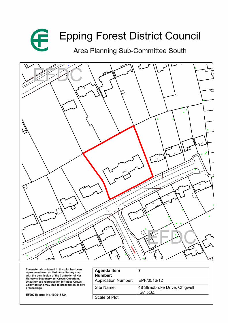
123
65.8m
37
51
1
41
5
44
6
45
43
49
47
33
56
13
60
79
75
48 to 52
54
69
GLEN
SIDE
Post
*
*
*
*
*
*
**
*
*
*
*
*
*
**
**
**
**
*
**
*
**
*
*
**
*
**
**
***
*
**
**
EFDC
EFDC
Epping Forest District CouncilArea Planning Sub-Committee South
The material contained in this plot has been reproduced from an Ordnance Survey map with the permission of the Controller of Her Majesty's Stationery. (c) Crown Copyright. Unauthorised reproduction infringes Crown Copyright and may lead to prosecution or civil proceedings.
EFDC licence No.100018534
Agenda Item Number:
7
Application Number: EPF/0516/12Site Name: 48 Stradbroke Drive, Chigwell
IG7 5QZScale of Plot:
Report Item No: 8
APPLICATION No: EPF/0601/12
SITE ADDRESS: 23 Princes RoadBuckhurst HillEssexIG9 5EE
PARISH: Buckhurst Hill
WARD: Buckhurst Hill West
APPLICANT: James Swain
DESCRIPTION OF PROPOSAL: Roof alterations including raising of roof pitch and rear dormer.
RECOMMENDED DECISION: Grant Permission (With Conditions)
Click on the link below to view related plans and documents for this case:http://planpub.eppingforestdc.gov.uk/AniteIM.websearch/ExternalEntryPoint.aspx?SEARCH_TYPE=1&DOC_CLASS_CODE=PL&FOLDER1_REF=536196
CONDITIONS
1 The development hereby permitted must be begun not later than the expiration of three years beginning with the date of this notice.
2 No construction works above ground level shall have taken place until documentary and photographic details of the types and colours of the external finishes have been submitted to and approved by the Local Planning Authority, in writing, prior to the commencement of the development. The development shall be implemented in accordance with such approved details.
3 All construction/demolition works and ancillary operations which are audible at the boundary of noise sensitive premises, shall only take place between the hours of 07.30 to 18.30 Monday to Friday and 08.00 to 13.00 hours on Saturday, and at no time during Sundays and Public/Bank Holidays unless otherwise agreed in writing by the Local Planning Authority.
This application is before this Committee since the recommendation differs from the views of the local council (Pursuant to Section CL56, Schedule A (g) of the Council’s Delegated Functions).
Description of Site:
The application site comprises an extended two-storey end-of-terrace house situated on the north side of Princes Road, opposite its junction with Forest Edge. The house has a gabled roof with a shallow pitch (25 degrees) while the adjoining house within the terrace, No 21, has a flat roof which appears prominent due to the additional width of that house. It is likely it once had pitched roofs but at some point they were replaced with the present flat roofs. Other neighbouring houses have pitched roofs of gabled design with approximately 35 degree pitches.
Land rises to the east such that a neighbouring pair of semi-detached houses, 25 and 27 Princes Road, are at higher level. Land also rises to the north with gardens set at a higher level.
The application site is not in a conservation area and there are no heritage assets within its vicinity.
Description of Proposal:
It is proposed to raise the ridge of the existing roof some 0.9m such that it would match the level of the ridge at 25 Princes Road. Its pitch would be increased as a consequence to 35 degrees.
It is also proposed to construct a box dormer on the rear facing roof slope of the enlarged roof. The dormer would be set below the ridge of the enlarged roof and 0.5m from the edge of the eaves. Its flanks would be set at the eastern side of an existing chimney that would be retained and 150mm from the western gable.
Relevant History:
None
Policies Applied:
CP2 Quality of Rural and Built EnvironmentDBE9 Loss of AmenityDBE10 Residential Extensions
Consultation Carried Out and Summary of Representations Received
Number of neighbours consulted. 2Site notice posted. No, not requiredResponses received:
21 PRINCES ROAD: object to the development for the reasons summarised as follows:
1. The development is not in keeping with the other properties in visible vicinity due to the size and design of the box dormer.
2. The cumulative impact of the proposed dormer and existing two-storey rear extension would serve to render the house more out of keeping with others in the vicinity.
3. The dormer will allow overlooking of the rear garden of 21, which will significantly reduce the privacy of the rear garden area.
4. The creation of an additional room in the roof would be likely to increase the amount of noise heard through the party wall.
5. The process of constructing the development would cause noise and disturbance.
BUCKHURST HILL PARISH COUNCIL: Objection – “Roof is out of keeping in the area in what may be a Conservation Area”
Main Issues and Considerations:
Design
The proposed raising of the ridge of the main roof of the house together with the associated increase in pitch would complement the design of the existing house and accord with the established pattern of development in the locality. The contrast with the flat roof of the attached

house would be emphasised but that would not be harmful. The proposed rear dormer would generally not be seen from the street, the only vantage point being a very restricted view between 23 and 25 Princes Road. In terms of its impact on the street scene, therefore, the proposal would respect its character and appearance and consequently is acceptable.
As a type of development box dormers are purely functional. They are not uncommon on the rear facing roof slope houses of this type. The proposed dormer would be of similar design and size to many that are normally constructed as permitted development. In this case planning permission is only required since the dormer relies on the proposed roof enlargement. The rear elevation of the house would appear inconsistent with its immediate neighbours as a consequence of the proposed dormer, however, since it would only be seen from private areas, predominantly rear gardens, the visual impact is limited and will not affect the public realm. In the circumstances, and since the overall size of the dormer is within the limits of what otherwise would be permitted development, its visual impact is acceptable.
The point made by the occupant of 21 Princes Road regarding the cumulative impact of the dormer and an existing two-storey projection is not supported since the two developments are entirely separate with the ridge of the two-storey addition set below the eaves of the main house. Furthermore, large two-storey rear projections are a form of enlargement found generally in the locality. It is not appropriate to link the existing extension to the proposed development in this particular case and overall, this proposal is acceptable in design terms on its own merits.
Living Conditions
The proposed rear dormer would facilitate a greater field of view than is available from first floor windows, however, that view is from a more remote position at a higher level and it would not take in the more private areas of rear neighbouring gardens adjacent to the rear elevation of houses since it faces away from them.
Any potential overlooking is also mitigated by structures on neighbouring land and changes in levels in rear garden areas. Aerial photographs of the locality taken in 2010 show the rear garden of 21 Princes Road is dominated by a large outbuilding, most probably a double garage, which is situated some 10m from the rear elevation taking up most of the garden width. An inspection of the application site also found a pergola has been constructed over that part of the rear garden of no. 21 between its boundary with the application site and the outbuilding. The outbuilding together with the pergola would screen views of the adjacent part of rear garden beyond those structures. Moreover, since the neighbouring gardens are at higher level than the ground level adjoining the rear of neighbouring houses the views from the proposed dormer would not be from a vantage point that could give a field of view comparable to a situation where there is no change in levels. Having regard to the particular facts of this case it is clear that the proposed rear dormer would not give rise to any excessive overlooking of neighbouring gardens.
In respect of the matter of potential noise transmission, while it is likely disturbance during the day would occur as a consequence of construction work, the noisy activity of such development would be likely to be limited to a few weeks. That does not amount to a reason to refuse to grant planning permission, but it is appropriate to include a condition on any consent given limiting the times of construction since the application site is a terraced house.
Once the development is complete it is difficult to see how noise from the proposed room in the new roof space could be transmitted to 21 Princes Road through a party wall since the enlarged roof would not adjoin any habitable area of no 21 because it has a flat roof. Even if it did not, insulation included with the floor and wall construction that is required under the Building Regulations would effectively isolate any noise arising from the use of the new room.
On the basis of the above assessment it is concluded that the proposal would not cause any excessive harm to the living conditions on any neighbouring property. Conclusion:
Careful consideration has been given to the objections raised to the proposal and it is concluded that they do not justify withholding consent for the proposal. The proposed development complies with relevant policies listed above and it is recommended that planning permission be granted.
Should you wish to discuss the contents of this report item please use the following contact details by 2pm on the day of the meeting at the latest:
Planning Application Case Officer: Stephan SolonDirect Line Telephone Number: 01992 564018
or if no direct contact can be made please email: [email protected]
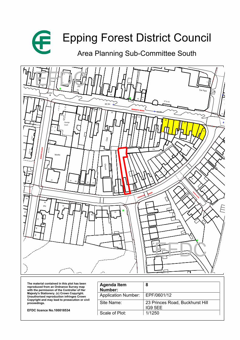
123
APPLICATION No: EPF/0608/12
39.6m
43.9m
46.3m
50.6m
1 to 10
Car Park
12
17
2
1
1
PegasusCourt
2
11
11a
7
18
2
1
11
13
28
27 to 43a
20
14
13a
42 40
53
45
56 52
50
40a
45
40
13
44a
27
Court
12
George
41 3
Clu
b
52a
8
31
Works
Church
3733
41
14 to 18
35 33a
1
PH
91011
63
3
14to
19
2
26
54
52
2024
PH
70
2567
65
76
76a
33
29
56
74
69
9 to
15
1 to
7
43
QUEEN'S ROAD
KIN
GS
PLA
CE
BACK LANE
PRINCESROAD
BRIAR CLOSE
TCB
Car Park
LB
*
*
*
*
*
EFDC
EFDC
Epping Forest District CouncilArea Planning Sub-Committee South
The material contained in this plot has been reproduced from an Ordnance Survey map with the permission of the Controller of Her Majesty's Stationery. (c) Crown Copyright. Unauthorised reproduction infringes Crown Copyright and may lead to prosecution or civil proceedings.
EFDC licence No.100018534
Agenda Item Number:
8
Application Number: EPF/0601/12Site Name: 23 Princes Road, Buckhurst Hill
IG9 5EEScale of Plot: 1/1250

Report Item No: 9
APPLICATION No: EPF/0608/12
SITE ADDRESS: 181 Princes RoadBuckhurst HillEssexIG9 5DJ
PARISH: Buckhurst Hill
WARD: Buckhurst Hill West
APPLICANT: Mr Mark Cherry
DESCRIPTION OF PROPOSAL: Loft conversion, raise ridge 600mm with two hip to gable roofs, two front pitched roof dormers, one rear pitched dormer and first floor pitched roof extension to rear.
RECOMMENDED DECISION: Grant Permission (With Conditions)
Click on the link below to view related plans and documents for this case:http://planpub.eppingforestdc.gov.uk/AniteIM.websearch/ExternalEntryPoint.aspx?SEARCH_TYPE=1&DOC_CLASS_CODE=PL&FOLDER1_REF=536232
CONDITIONS
1 The development hereby permitted must be begun not later than the expiration of three years beginning with the date of this notice.
2 Materials to be used for the external finishes of the proposed development, shall match those of the existing building, unless otherwise agreed in writing by the Local Planning Authority.
3 Within 3 months of the substantial completion of the development hereby approved, the proposed window opening in the half-dormer in the south-east flank elevation of the enlarged rear projection of the house shall be entirely fitted with obscured glass and have fixed frames to a height of 1.7 metres above the floor of the room in which the window is installed and shall be permanently retained in that condition.
This application is before this Committee since the recommendation differs from the views of the local council (Pursuant to Section CL56, Schedule A (g) of the Council’s Delegated Functions).
Description of Site:
The application site comprises a two-storey detached house situated on the north-east side of Princes Road, adjacent to its junction with Wimborne Close. The house has a single-storey and part single, part two-storey rear extension. The main roof is hipped while the two-storey part of the existing rear projection has a gabled roof.
The house is set between two much extended detached houses with prominent steeply pitched roofs. The neighbour to the south east, no 179 has a pair of dormer windows to the front slope of
an enlarged roof while 183 is dominated by strong gable features to the front of the roof, rear of which is a crown roof.
Land rises to the north-west. The site is not in a conservation area and there are no heritage assets within the vicinity.
Description of Proposal:
It is proposed to convert the hipped main roof of the house to a gabled design, raise its ridge 600mm and in doing so increase its pitch to 42 degrees. It is also proposed to raise the ridge of the two-storey rear projection to match. The eaves of the rear projection would also be raised 600mm. A single rear dormer and two modest front dormers, all with gabled roofs set below the ridge, would also be constructed on the main roof. The raised roof over the rear projection would include an obscure glazed half dormer window in the south east flank.
The proposal would be finished in materials to match the existing house
Relevant History:
EPF/1002/04 Single-storey rear extensions ApprovedCLD/EPF/2293/11 Certificate of lawful development for a proposed hip to gable roof alteration
and rear dormer window in a loft conversion. Granted
Policies Applied:
CP2 Quality of Rural and Built EnvironmentDBE9 Loss of AmenityDBE10 Residential Extensions
Consultation Carried Out and Summary of Representations Received
Number of neighbours consulted. 23Site notice posted. No, not requiredResponses received: No response from neighbours.BUCKHURST HILL PARISH COUNCIL: Objection raised on the basis that the Parish has “Concerns that this may be out of keeping with the area in what may be a Conservation Area”.
Main Issues and Considerations:
The proposal is very sympathetically designed and would complement the appearance of the house. Indeed, the proposal is a considerable improvement over the roof enlargement that benefits from a certificate of lawfulness since that includes a large box dormer.
The raising of the ridge of the main roof and increasing its pitch would result in the house that more closely corresponds to the height and pitch of its immediate neighbours while the proposed front dormers would reflect those existing at no. 179 Princes Road. As a consequence the proposal would give the house an appearance that more closely respects the pattern of development set by its neighbours thereby enhancing the character and appearance of the locality. Should consent be granted, a condition requiring materials to match those of the existing house would serve to secure a complimentary appearance.
Due to the relationship of the house with its immediate neighbours, which have substantial two-storey rear projections beyond the original rear main wall of 181 Princes Road, there is no potential for the proposal to cause any loss of light or give rise to any excessive overlooking. The proposal would therefore safeguard the living conditions of neighbouring properties. Should
consent be granted, a condition requiring the window in the half dormer of the enlarged rear projection would serve to safeguard the privacy of properties to the south-east.
Conclusion:
The proposed development complies with relevant policies listed above and it is recommended that planning permission be granted.
Should you wish to discuss the contents of this report item please use the following contact details by 2pm on the day of the meeting at the latest:
Planning Application Case Officer: Stephan SolonDirect Line Telephone Number: 01992 564018
or if no direct contact can be made please email: [email protected]

123
70.4m
75.0m
77.1mFlats
MewsQueens
1 to 7
147147a
72
74
194d
194 to
137
129a131
150
129
56b 56a58
124
147
128
143
151
12
ToraCourt
Wor
ks
Fact
ory
149
143
1 to 8
160a
Court
162
Mirravale
135
160
144
155a
1 to 12
157a
155
159
157b
2
157
76
70
1 to 8
149149a
Gunnels
Hastingwood
and
151
170
Court
Court
152
146
1
20
5
179
169
86
4137
84
39
98
178
176c
Library
176a
159
15
30
2
ElSub Sta
4
13
31
168
191
158a
154
160
168a
18915
8
184 186
Bank
PO
175
188 to192
182
171
171511
25
27
168b
170
7
10
26
21
2018
28
15
12
196
189
176
179
WIMBORNE
CLOSE
PR
INC
ES
WA
Y
WOODSIDE
WIMBORNE CLOSE
Park
FBs
CarEFDC
EFDC
Epping Forest District CouncilArea Planning Sub-Committee South
The material contained in this plot has been reproduced from an Ordnance Survey map with the permission of the Controller of Her Majesty's Stationery. (c) Crown Copyright. Unauthorised reproduction infringes Crown Copyright and may lead to prosecution or civil proceedings.
EFDC licence No.100018534
Agenda Item Number:
9
Application Number: EPF/0608/12Site Name: 181 Princes Road, Buckhurst Hill
IG9 5DJScale of Plot: 1/1250