Embed Size (px)
Citation preview
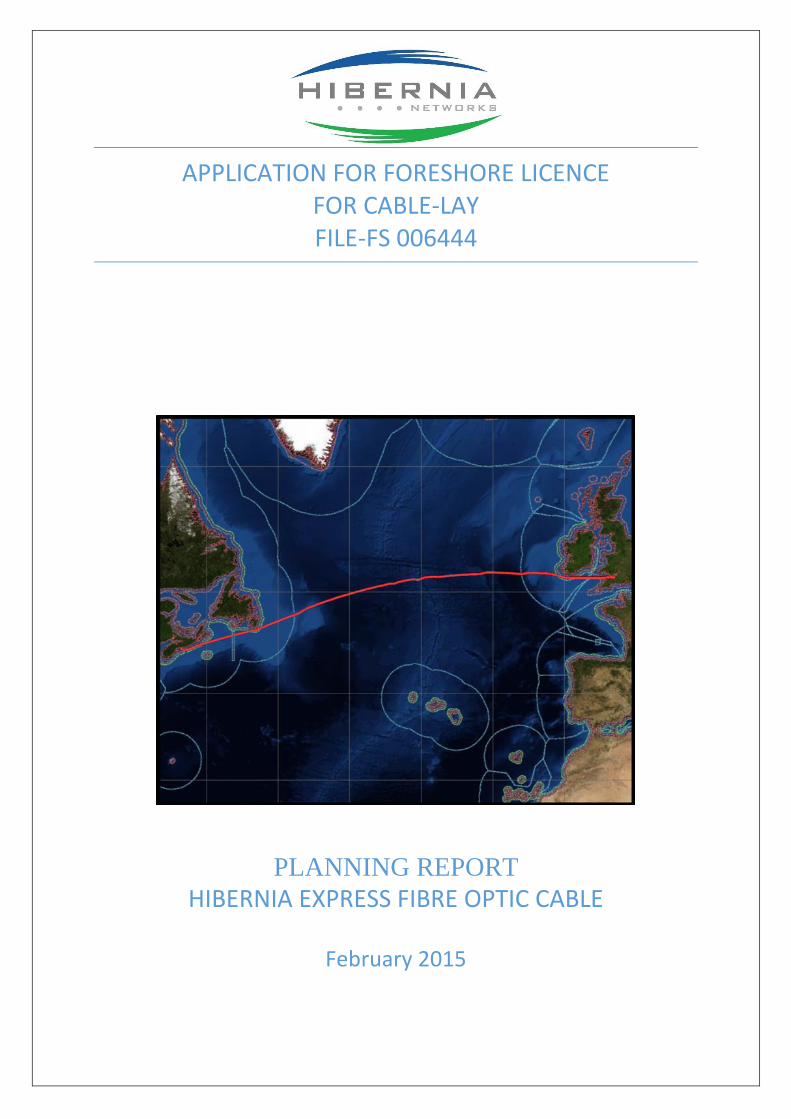
APPLICATION FOR FORESHORE LICENCE FOR CABLE-LAY FILE-FS 006444
PLANNING REPORT HIBERNIA EXPRESS FIBRE OPTIC CABLE
February 2015

February 2015 1 Hibernia Express Fibre Optic Cable Cable Lay
CONTENTS
1.0 GENERAL PROJECT OVERVIEW
2.0 PLANNED ROUTE
3.0 CABLE INSTALLATION
4.0 INSTALLATION PROCEDURE
5.0 SUBSEA CABLE DESIGN
6.0 MARINE ARCHAEOLOGY
7.0 APPROPRIATE ASSESSMENT SCREENING
APPENDIX 1 APPROPRIATE ASSESSMENT SCREENING
APPENDIX 2 DRAWINGS

February 2015 2 Hibernia Express Fibre Optic Cable Cable Lay
1.0 GENERAL PROJECT OVERVIEW
1.1 The Hibernia Express Cable System is a subsea fibre optic cable system, 4,250km in length, to connect
Canada and the United Kingdom with a branch to Ireland. The cable is planned to extend from Halifax,
Nova Scotia to Brean in Somerset. The link to Ireland will extend from a Branching Unit, 44km off the
Cork coast, to Garrettstown, which is 12km south of Kinsale.
1.2 The Hibernia Express Cable System will provide Hibernia Express and its constituent clients with a low-
latency, reliable and secure submarine network to interface with telecoms gateways at these landing
locations in three countries.
1.3 An overview of the trans-Atlantic route is shown in Fig 1.1
Courtesy of TeSubCom
Fig. 1.1 Hibernia Express Cable System Overview

February 2015 3 Hibernia Express Fibre Optic Cable Cable Lay
2.0 PLANNED ROUTE
2.1 The planned route of the trans-Atlantic cable is approximately 40km off the Irish coast. The branch to
Cork runs virtually north–south from the Branching Unit into Courtmacsherry Bay and the general
route layout is shown in Fig. 2.1. The planned route crosses the 12-mile limit at 51 ° 22.531’ N, 08°
38.226’ W, or KP 30. The Route Position List is presented in Appendix 1 in Lat/Long to WGS 84.
Kilometre Points (KP), together with Turning Points (TP), are also shown in Fig 2.1.
2.2 Figure 2.1 also shows the Kinsale Head Gas Field platforms, and the wreck zone of the Lusitania. The
planned route is well away from the Kinsale Head Gas Field and is 5.62km west of the wreck of the
Lusitania and 4.2km west of the boundary of the wreck zone. The approximate location of the 12-mile
limit is also shown.
2.3 At 51 ° 23.9413’ N, 08 ° 37.9580’ W, or KP 27.5, the route enters the EL 5/07 (Lansdowne Celtic Sea)
Licence Block. At 51 ° 18.9431’ N, 08 ° 38.9076’ W, or KP 36.8, the route enters IR LO12/4 (Providence
Resources) Licence Block. The Cork Branch ends within this block at 51 ° 15.0760’ N, 08° 39.2900’ W,
KP 44.1, at the Branching Unit.
Sub Sea Pipelines
2.4 There are no subsea pipelines in the vicinity of the planned cable and there are no pipeline crossings.
Sub Sea Cables
2.5 The Hibernia Express Cable crosses the Hibernia Segment D cable, which runs from Sutton to Boston,
at a point 52km offshore. That cable is owned and operated by Hibernia Express and the crossing is
not an issue.
2.6 Other than the Out-of-Service PTAT cable, there are no other cables in the vicinity of the planned
cable and there are no cable crossings within the 12-Mile Limit.

February 2015 4 Hibernia Express Fibre Optic Cable Cable Lay
2.7 The figure shows the line of the former PTAT branch. That cable is no longer in service and its
limitations are such that there are no plans to bring it back into use. The planned route of the Cork
Branch of the Hibernia Express Cable has been discussed with PTAT and PTAT have no concerns or
objection in relation to it. The planned route is close and parallel to the out-of-service cable over a
distance of 4.1 km. At 51° 36.4981’ N, 08°. 35.5645’ W the out-of-service cable turns to the south east
and is no longer a factor beyond that point. The section of PTAT which is close to the planned route
will be identified prior to main-lay and will be avoided.

February 2015 4 Hibernia Express Fibre Optic Cable Cable Lay
Fig. 2.1 General Layout showing the Hibernia Express Main Cable and the Cork Branch.

February 2015 5 Hibernia Express Fibre Optic Cable Cable-Lay
12-Mile Limit Zone
2.8 Figure 2.2 shows the cable route within the 12-Mile Limit.
Fig. 2.2 The Cable Route Within the 12-Mile Limit
12 Mile Limit
Out of Service
PTAT Cable
Latitude 51° 22.531' N
Longitude 8° 38.226' W
February 2015 6 Hibernia Express Fibre Optic Cable Cable-Lay
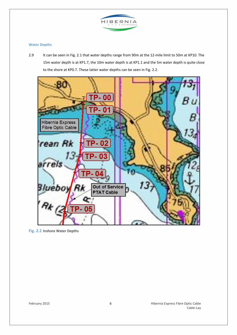
Water Depths
2.9 It can be seen in Fig. 2.1 that water depths range from 90m at the 12-mile limit to 50m at KP10. The
15m water depth is at KP1.7, the 10m water depth is at KP1.1 and the 5m water depth is quite close
to the shore at KP0.7. These latter water depths can be seen in Fig. 2.2.
Fig. 2.2 Inshore Water Depths

February 2015 7 Hibernia Express Fibre Optic Cable Cable-Lay
Advance Works
2.10 A separate Foreshore Licence has been sought for Advance Works (File FS 006443). The extent of the
Advance Works is shown on Figs 2.3 & 2.4.
Fig. 2.3 Extent of Advance Works on 6” Ordnance Survey Map – (Refer to FS 006443)
Fig. 2.4 Extent of Advance Works on 1/2,500 Ordnance Survey Map – (Refer to FS 006443)

February 2015 8 Hibernia Express Fibre Optic Cable Cable-Lay
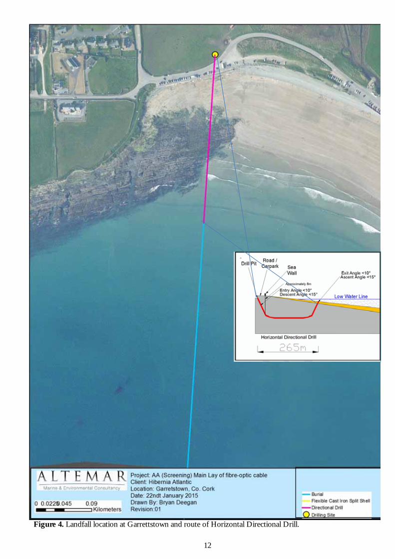
2.11 The Advance Works comprise the installation of a “drill & leave” steel pipe (ID 109mm) by way of a
Horizontal Directional Drill. The HDD will extend from a Beach Manhole onshore to a point beyond
the Low Water Line at a water depth of 1m LAT. This seaward end of the Horizontal Directional Drill
will be approximately 210m from the High Water Line. The completion of the Advance Works involves
the installation of a messenger line in the steel pipe and temporarily capping the pipe pending the
Main-Lay installation of the fibre optic cable.
2.12 When the Main-Lay vessel arrives the cable will be attached to a messenger line in the steel pipe. The
cable will then be pulled ashore through the steel pipe. This method of construction ensures that at
no stage will there be any work at the sea wall or any trench excavation on the beach at
Garrettstown.

February 2015 9 Hibernia Express Fibre Optic Cable Cable-Lay
3.0 CABLE INSTALLATION
3.1 The planned route of the cable extends from the 12-mile limit towards the coast to link up with the
end of the HDD pipe at KP 0.265 which is seaward of the Low Water Line at a water depth of 1 metre
below LAT. (See Figs 2.1 & 2.2)
Offshore Installation – Branching Unit to KP 1.7
3.2 The Main Lay vessel will lay cable from the Branching Unit proceeding towards the shore at
Garrettstown. The Main-Lay vessel will cease cable installation at approximately KP 1.7, which is
100m seaward of an offshore reef. Sea-bed data indicates that from the 12-mile limit (KP 30) into KP
1.7 it will be possible to achieve cable burial by either direct ploughing or post-lay jetting. Target
depth of burial is 1.5m.
Inshore Installation – KP 1.7 to KP 0.265
3.3 The inshore reef extends towards the shore over a distance of 400m from KP1.6 to approximately KP
1.2, where the water depth is approximately 12m. It is planned to lay the cable directly on the sea
floor over this length of rocky seabed using articulated cast-iron split pipe to provide additional
protection for the cable. The split-pipe will be fitted by divers in a post-lay operation.
Shore End Installation
3.4 At the inshore end the HDD pipe will be uncapped, a bell-mouth attachment will be fitted to the end
of the pipe, and the messenger wire will be attached to a winch onshore at the Beach Manhole. The
fibre optic cable will then be pulled through the HDD pipe into the Beach Manhole.
3.5 When the cable has been pulled through the HDD pipe into the Beach Manhole the section of surface-
laid cable from the end of HDD pipe out to KP 1.2 will be buried in the sandy seabed in a post-lay
jetting operation. Articulated cast-iron split pipe will also be fitted to the cable over a length of 5m
extending from the end of the HDD pipe.

February 2015 10 Hibernia Express Fibre Optic Cable Cable-Lay
3.6 A summary of the cable installation is as follows;
Section Water Depth
12-Mile Limit to KP 1.7 90m – 15m Cable either plough buried or post-lay buried by jetting. KP 1.7 to KP 1.2 15m – 12m Cable laid on rocky seabed and fitted with split- pipe for additional protection over a length of 400m over rocky seabed from KP 1.2 to KP 1.6 KP 1.2 to KP 0.265 12m – 1m Cable laid on sandy seabed and post-lay buried by jetting KP 0.265 to BMH 1m – HWM Cable pulled through a pre-installed HDD pipe
(Advance Works)

February 2015 11 Hibernia Express Fibre Optic Cable Cable-Lay
4.0 Method of Procedure
Pre-Lay Grapnel Run (PLGR)
4.1 In areas of planned burial, the route is first cleared of any seabed debris via a “Pre-Lay Grapnel Run”.
The swathe of the grapnel is less than one metre wide, and there will be minimal disturbance to the
seabed during the debris clearance operation.
4.2 The PLGR vessel will use a DGPS positioning system. The route followed by the PLGR will be
maintained as close as practicable to the selected planned burial route and always within the swathe
of the route survey.
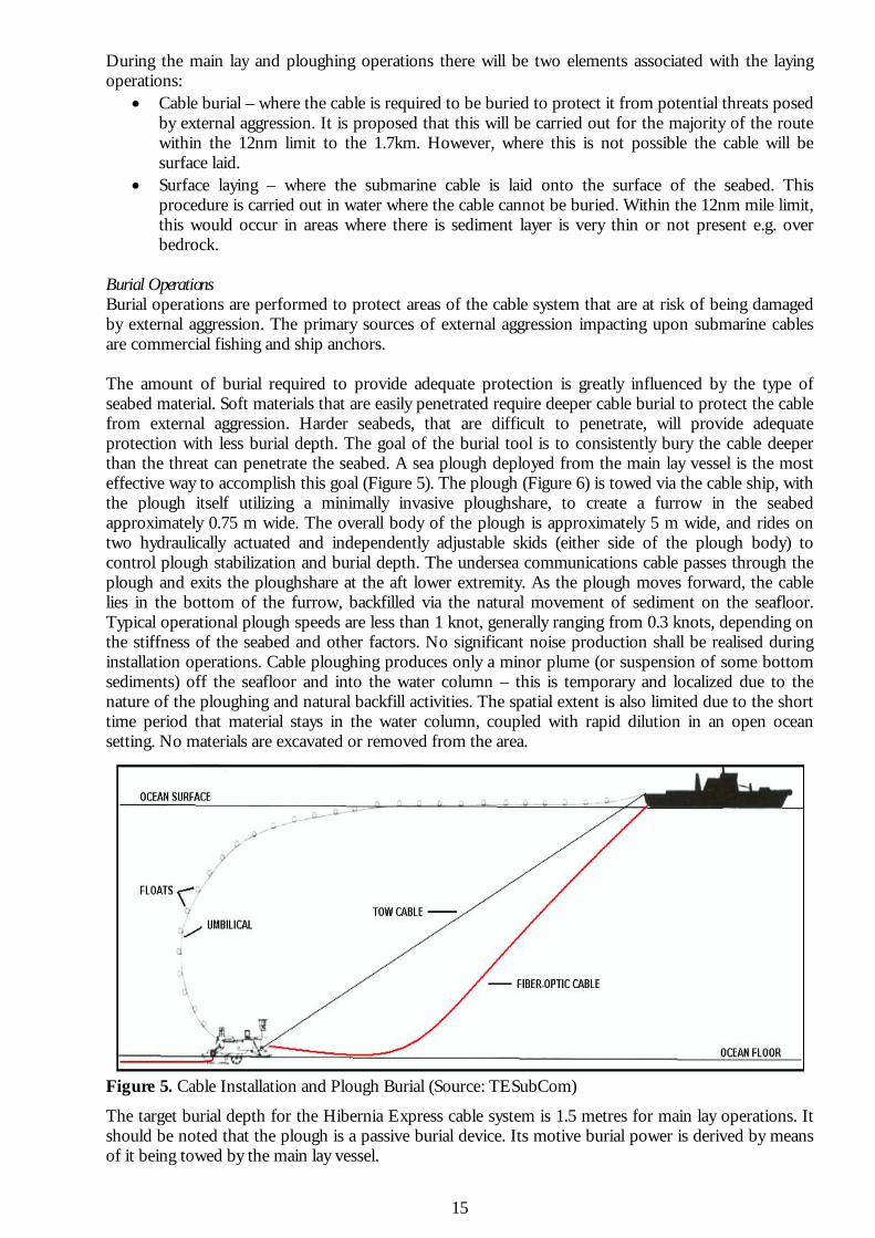
Cable Lay & Direct Burial
4.3 The section of cable from KP 0.265 out to the 12-Mile Limit (and onward to the Branching Unit) will be
either surface-laid on the sea-floor or direct-buried in the sea-bed where sediment cover is present. In
the case of direct-burial, a sea-plough will be lowered into position on the sea-bed and then towed by
the cable ship at the same time as the cable is being deployed (Fig 2.7). The sea-plough utilises a
minimally invasive ploughshare to create a furrow in the sea-bed approximately 0.75 metres in width.
Courtesy of TeSubCom
Fig 4.1 Sea Plough Burial
4.4 The overall body of the plough is approximately 5m wide and rides on two hydraulically actuated and
independently adjustable skids (on either side of the body of the plough) to control plough stability
and depth of burial (Fig 4.2). The undersea communications cable passes through the plough and exits
the ploughshare at the aft lower extremity. As the plough moves forward the cable lies in the bottom
of the furrow and the seabed then re-forms via the natural movement of sediment on the sea-floor.
Typical operational plough speeds are from 0.3 up to 1 knot, depending on the stiffness of the sea-
bed.

February 2015 12 Hibernia Express Fibre Optic Cable Cable-Lay
Courtesy of TeSubCom
Fig 4.2 Typical Sea Plough
4.5 The target burial depth for the Hibernia Express cable system is 1.5 metres for main-lay operations. It
is important to note that target burial depth is subject to change, based on sea-bed conditions.
4.6 It is to be noted that the sea-plough is a passive burial device. Its motive power is derived by means of
it being towed by the main-lay vessel.
4.7 No significant noise is generated during cable deployment and plough burial operations. Cable
ploughing produces only a minor plume (or suspension of some sea-bottom sediments) off the sea-
floor into the water column – this is temporary and localized due to the nature of the ploughing and
natural backfill activities. The spatial extent is also limited due to the short time period that material
stays in the water column, coupled with rapid dilution in an ocean setting. No materials are excavated
or removed from the route of the cable.

February 2015 13 Hibernia Express Fibre Optic Cable Cable-Lay
Surface Lay Operations on the Sea Floor
4.8 While surface laying, the cable is deployed according to the seabed profile, cable types, and bottom
characteristics with the intention that the cable moulds itself to the bottom contours (Fig 4.3). Prior
to the laying operation, all relevant data from the route survey will be studied and a cable laying plan
will be developed. The cable will be deployed in accordance with this plan. Real-time calculations
used to monitor and control the cable deployment parameters will be performed by Cable Engineers
during the installation. Cable Engineers regularly compare the distance travelled along the route with
the amount of cable laid. The route distance travelled is calculated directly from the outputs of the
navigation system (DGPS) and the length of cable laid is taken directly from kilometre markings on the
cable and/or from the cable counter located in the cable pay-out line. A computer regularly samples
incremental route distance and incremental cable distance and thus cable slack calculations are
performed.
Courtesy of TeSubCom Fig 4.3 Laid Cable on the Sea Floor

February 2015 14 Hibernia Express Fibre Optic Cable Cable-Lay
4.9 All cable laying activities will be closely monitored and the on-board engineers will be utilizing the
latest advancements in the undersea cable installation industry in order to ensure the cable is laid
according to the As-Engineered design. Cable handling machinery includes two 30 Ton Cable Drums
and a 20 wheel pair Linear Cable Engines (LCE) allowing for precise handling and monitoring of all
aspects of the cable lay.
4.10 By utilizing cable slack management techniques during the surface laying operations, the on-board
engineers will ensure that there is enough cable to allow for the conforming of the system to the
various undulations and features on the seabed as identified during the survey operations.
Post-Lay Burial
4.11 Following the main-lay operations, a post lay inspection and burial programme may be carried out in
certain areas to inspect the laying and burial of the cable in the sea-bed. A post-lay burial operation
may be performed in order to supplement the burial operations at locations which include the
following locations;
Ploughshare change locations
Surface laid sections arising from plough malfunction
Unplanned recoveries due to weather delay.
4.12 In these areas requiring post lay burial a separate Remotely Operated Vehicle (ROV) is utilised
(Fig 4.4). The ROV typically uses a jetting tool to bury the cable to the required depth. The jets are
directed into the sea-bed so as to emulsify it. The ROV jetting system slowly moves along the sea-bed
on the required cable track and forms a trench into which the cable is placed. It is to be noted that the
surrounding sea water is used for the jetting system, i.e. nothing alien is introduced into the natural
environment. The water jetting system does not remove any sea-bed materials from the area and
they naturally re-form and “backfill” the trench after the passage of the ROV.

February 2015 15 Hibernia Express Fibre Optic Cable Cable-Lay
Courtesy of TeSubCom Fig 4.4 ROV Post Lay Burial
Post-Lay Burial (Dive Spread)
4.13 The offshore cable burial from HDD exit to Vessel position will be conducted using Diver Jetting from
the dive boat. The diving team will be deployed underwater to install the split pipes. Upon the
completion of the split pipe installation, the dive team will begin burial of the cable. Diver burial will
be completed by using a water jet nozzle/similar device by a diver jetting the seabed or burial
machine. There may also be the need for successive jetting passes to bury the cable to the target
depth if diver burial method is used. A survey pole will then measure the burial depth. Upon
completion of cable burial and post installation survey, a diver post installation video will take place, if
applicable.

February 2015 16 Hibernia Express Fibre Optic Cable Cable-Lay
Articulated Split Pipe
4.14 Articulated Split Pipe is produced in Ductile Iron ASTM A536 Gr 65-45-12. The articulated pipe
provides abrasion and excellent impact resistance for submarine cables. The articulated split pipe
units (Figs 4.5 & 4.6) are generally 0.5m in length and two bolts are installed every 5m.
Courtesy of TeSubCom Fig 4.5 Typical Articulated Split Pipe
Courtesy of TeSubCom
Fig 4.6 Typical Split Pipe Instalment

February 2015 17 Hibernia Express Fibre Optic Cable Cable-Lay
5.0 SUBSEA CABLE DESIGN
5.1 TE Subcom’s SL cable is an industry standard core cable which is utilized in all present TE Subcom fibre
optic telecommunications cable systems throughout the world. Information such as high-speed data
and voice is transmitted via lightwave through the optical fibres contained within the central Unit
Fibre Structure (UFS). Double Armour Cable will be used in Irish waters and a cut-away section of the
Double Armour Cable is shown in Fig 5.1.
Courtesy of TeSubCom
Fig 5.1 Cut-Away Section of Double Armour Cable
5.2 The UFS is the innermost element of the cable and consists of optical fibres embedded in a buffer gel
material inside a Polybutylene Terephthalate plastic tube. The buffer gel is a thixotropic material that
protects the optical fibres from shear stresses associated with movement inside the tube. Ultra-high
strength steel wires are helically wrapped around the UFS and together they act as a pressure vessel
that protects the UFS from stresses up to and in excess of 100 MPa. The interstices between the steel
wires are filled with a hydrophobic elastomeric water-blocking material which resists longitudinal
water ingress. The SL design includes a copper sheath around the high strength wires. A thin layer of
ethylene-acrylic and copolymer plastic resin and a thick layer of polyethylene insulating jacket are
coextruded over the copper sheath. The polyethylene jacket provides insulation, abrasion resistance
and corrosion protection.

February 2015 18 Hibernia Express Fibre Optic Cable Cable-Lay
5.3 The double armour, consisting of two layers of galvanised wire wrapped around the cable, is coated
with hot-blown petroleum asphalt and wound with asphalt-soaked yarn. The finished DA Cable has an
outer diameter of 35.9mm. Detailed data on the cable is presented in Table 1.
Courtesy of TeSubCom
Table 1 – Details of Double Armour Cable
5.4 The double armour, consisting of two layers of galvanised wire wrapped around the cable, is coated
with hot-blown petroleum asphalt and wound with asphalt-soaked yarn. The finished DA Cable has an
outer diameter of 35.9mm. Detailed data on the cable is presented in Table 1.
SL Cable Materials
5.5 For all TE SubCom SL cable types, the materials utilized in the external-most layer in direct contact
with the marine environment have extremely low water solubility and are inert in marine
environments. The materials used in the external-most SL cable designs include Medium Density
Polyethylene (MDPE), High Density Polyethylene (HDPE), and for armoured cable designs, yarns and
asphalt. The following sections address the environmental behaviour of the materials in contact with
seawater.

February 2015 19 Hibernia Express Fibre Optic Cable Cable-Lay
Environmental Characteristics of Medium Density Polyethylene (MDPE) (SL-17 and SL-21)
5.6 On a percentage basis, MDPE insulated SL-LW cable is the most widely used cable in undersea cable
systems. MDPE is a water-insoluble polymeric solid that has a relatively high molecular weight. In an
aquatic environment, the outermost MDPE layer is inert and non-toxic and provides protection to the
SL cable. The non-toxic nature of MDPE is exhibited by its pervasive use in aquaculture hatchery
tanks for the rearing of fish and lobster egg and larvae during sensitive life-stages.
Environmental Characteristics of Asphalt
5.7 The asphalt coating used on armoured SL cables has low water solubility and is inert and non-toxic in
the aquatic environment. These characteristics are well supported by a study and test plan
conducted by the American Petroleum Institute (API) for the ‘asphalt category’ the results of which
are reported on the U.S. Environmental Protection Agency’s Chemical Right-to-Know HPV Challenge
Program web-site (http://www.epa.gov/HPV/pubs/summaries/asphlcat/c14901tc.htm ). Conclusions
of this test study include:
Stability in Water
Hydrolysis of an organic chemical is the transformation process in which a water
molecule or hydroxide ion reacts to form a new carbon oxygen bond. Materials in
the asphalt category are not subject to hydrolysis as they lack listed reactive
groups.”
Absence of Toxicity to Aquatic Plants and Invertebrates
“Asphalt and vacuum residue are not expected to cause acute or chronic toxicity to
aquatic organisms due to the extremely low water solubility of these materials. This
is supported by aquatic toxicity data from other petroleum products having similar
types of hydrocarbon constituents. “
“Asphalt and vacuum residue, which contain saturate and aromatic hydrocarbon
molecules of C25 or higher, also would not be considered sufficiently water soluble
to elicit acute or chronic toxicity in aquatic animals and plants.”

February 2015 20 Hibernia Express Fibre Optic Cable Cable-Lay
“Fish hatchery ponds lined with hot-mix asphalt are operated by the Oregon
Department of Fish and Wildlife and the Washington State Department of Fisheries
who produce millions of high quality fish each year.” U.S. Environmental Protection
Agency Comments
“EPA agrees with the stability in water information provided by the submitter. EPA
agrees with the use of analog data to satisfy the ecological effects endpoints for the
asphalt category. The analog data provided are considered worst-case scenario, in
that asphalt category members are more water-insoluble than the analogs.
Therefore, asphalt category members are not likely to show acute or chronic
ecological effects in aquatic species.”

February 2015 21 Hibernia Express Fibre Optic Cable Cable-Lay
6.0 MARINE ARCHAEOLOGY
6.1 Geophysical Surveys in the form of Bathymetry, Side Scan Sonar, Sub – Bottom Profiling and
Magnetometer were carried out in early 2014. These surveys were carried out under licence Nos.
14R005 issued by the Department of Arts, Heritage and the Gaeltacht.
6.2 The capture of the survey data was witnessed by Geo-Mara Ltd. and the analysis of the data was
carried out by Geo-Mara Ltd. A copy of the Marine Archaeology Report is included in Appendix 1.
6.3 The Non-Technical Summary of the Marine Archaeology Report is as follows:
Geomara Ltd. was commissioned by TE Subcom to undertake a maritime cultural heritage impact
assessment in connection with the proposed Hibernia Express transatlantic fibre optic cable project.
This report addresses the section within the Irish jurisdiction.
The assessment comprises an introduction to the study area; and the identification of cultural heritage
sites, features and deposits located along the proposed cable route corridor. In order to provide a
comprehensive assessment, an extensive desk based study of the route corridor was undertaken. In
addition, archaeological analysis and assessment was undertaken of marine geophysical and
hydrographic survey data collected under detection device licence no. 14R005. The potential impact of
the proposed scheme on the receiving environment is addressed and mitigation measures to ameliorate
these impacts are presented.
The assessment concludes that the area surrounding the landfall has been the site of continued human
occupation since earliest times. It also recorded the presence of shipwreck remains 185m from the
proposed cable centreline. The name of this vessel, its date of sinking and its archaeological
significance could not be determined during the geophysical and hydrographic survey. Consequently,
further mitigation will be required to determine if these wreck remains are historic or modern.
Consequently, given the results of the impact assessment the mitigation strategies outlined here detail
the measures to be adopted in order to ameliorate any unforeseen direct, indirect and secondary
impacts that the proposed cable may have on features of maritime cultural heritage interest. If these
measures are employed it is envisaged that the proposed cable installation will have no impact on
features of maritime cultural heritage interest.

February 2015 22 Hibernia Express Fibre Optic Cable Cable-Lay
The following mitigation recommendations are presented in connection with the proposed cable:
1. 1. It is recommended that an archaeological dive inspection survey be carried out on the wreck (HE-
WRK1) identified during geophysical and hydrographic survey operations. The objective of the
inspection dive should be to identify the wreck remains and to determine the nature, age and extent of
the remains. The extent of the exclusion zone required for the wreck remains will be informed by the
results of the archaeological dive inspection survey.
2. It is recommended that all sites of cultural heritage interest identified in this report are avoided.
3. It is recommended that procedures should be put in place to ensure that any previously unrecorded
cultural heritage assets encountered during the project should be assessed by a suitably qualified
archaeologist.
4. Should the proposed cable route be subject to further revision, details of these revisions
should be forwarded to the project archaeologist for assessment.
5. On completion of the cable installation a report will be produced summarising all
archaeological aspects of the project and submitted to DAHG and the National Museum of
Ireland.

February 2015 23 Hibernia Express Fibre Optic Cable Cable-Lay
7.0 APPROPRIATE ASSESMENT SCREENING
7.1 An Appropriate Assessment Screening Report was commissioned to cover both the Advance Works
and Cable-Lay elements. The work was carried out by Altemar Ltd. as part of this application process
and a copy of the formal report is incorporated in the Planning Report in Appendix 1.
7.2 The basic findings of the Appropriate Assessment Screening Report are that there is no significant
impact on Natura 2000 Sites or their site-specific conservation objectives in either the intertidal or
subtidal elements of the project.

February 2015 24 Hibernia Express Fibre Optic Cable Cable-Lay
Appendix 1
Appropriate Assessment Screening Report

i
NATURA Impact Statement
Appropriate Assessment Screening for advance works and main lay (Foreshore Licence Applications) for Cork Branch of the
Hibernia Express trans-Atlantic fibre-optic cable, landing at Garrettstown, Co. Cork.
(Final Draft)
5th February 2015 Prepared by:
Bryan Deegan (MCIEEM) of Altemar Ltd. On behalf of: Hibernia Express
Altemar Ltd., 50 Templecarrig Upper, Delgany, Co. Wicklow. 00-353-1-2010713. [email protected] Directors: Bryan Deegan and Sara Corcoran Company No.427560 VAT No. 9649832U
www.altemar.ie

ii
Document Control Sheet
Client Hibernia Express
Project Appropriate Assessment Screening for advance works and main lay (Foreshore Licence Applications) for Cork Branch of the Hibernia Express trans-Atlantic fibre-optic cable, landing at Garrettstown, Co. Cork.
Report Appropriate Assessment Screening (Final Draft)
Date 5th February 2015
Project No: Document Reference: AA_HE_FO_FD
Version Author Reviewed Date
Draft 01 Bryan Deegan Sara Corcoran 18th October 2014
Draft 02 Bryan Deegan Sara Corcoran 15th December 2014
Draft 03 Bryan Deegan Sara Corcoran 15th January 2015
Final Draft Bryan Deegan Sara Corcoran 5th February 2015

iii
CONTENTS1. Introduction .................................................................................................................................................................... 4
Background to Altemar Ltd. ......................................................................................................................................... 4 2. Background to the Appropriate Assessment ............................................................................................................. 5
Plans & Projects ............................................................................................................................................................. 6 3. Stages of the Appropriate Assessment ........................................................................................................................ 7 4. Screening Stage ............................................................................................................................................................... 8
A) MANAGEMENT OF THE SITE .................................................................................................................. 8 B) RELEVANCE TO THE COUNTY DEVELOPMENT PLAN ............................................................................. 8 C) DESCRIPTION OF THE PROPOSED PROJECT ............................................................................................ 9
1) Background ............................................................................................................................................................. 9 2) Route within 12nm ................................................................................................................................................ 9 3) Alternative Sites ...................................................................................................................................................... 9 4) Horizontal Directional Drill ............................................................................................................................... 13 5) Beach Manhole ......................................................................................................................................................... 14 6) Main Underwater Lay Procedure ....................................................................................................................... 14 7) Cable Characteristics ........................................................................................................................................... 18
D) IDENTIFICATION OF NATURA 2000 SITES/HABITATS & SPECIES ....................................................... 19 E) INITIAL SCREENING OF NATURA 2000 SITES, ANNEX HABITATS AND SPECIES WITHIN 15KM OF THE
PROPOSED ROUTE AND LANDFALL INCLUDING SITE SPECIFIC CONSERVATION OBJECTIVES (SSCO’S) ......... 28 Additional Annex I Habitats, Annex II and IV Species in the vicinity of the Cable Laying ............................ 29
IMPACTS ON SITE SPECIFIC CONSERVATION OBJECTIVES AND ANNEX HABITATS ........................................ 30 1) Conservation Objectives and overall status of species and habitats in Old Head of Kinsale SPA (IE0004021). ................................................................................................................................................................. 30 2) Conservation Objectives and overall status of species and habitats in Courtmacsherry Bay SPA (IE 0004219). ....................................................................................................................................................................... 31 3) Conservation Objectives and overall status of species and habitats in Seven Heads SPA (IE0004191) 32 4) Conservation Objectives and overall status of species and habitats in Courtmacsherry Estuary SAC (IE0001230) .................................................................................................................................................................. 33 5) Additional Annex I Habitats, Annex II and IV Species in the vicinity of the Cable Laying .................... 34 Annex I Habitat- 1170 Reef ....................................................................................................................................... 34
F) FIELD OBSERVATIONS AT GARRETTSTOWN BEACH, CO. CORK. ......................................................... 37 G) CUMULATIVE IMPACTS ....................................................................................................................... 40 H) POTENTIAL IMPACT AND THE SIGNIFICANCE OF THE IMPACT .............................................................. 41 I) MITIGATION MEASURES ........................................................................................................................ 42 J) FINDING OF NO SIGNIFICANT EFFECTS REPORT ..................................................................................... 43 K) REFERENCES ...................................................................................................................................... 44
Appendcies ............................................................................................................................................................................ 45 APPENDIX I: PROPOSED NATURAL HERITAGE AREAS WITHIN 15KM OF THE PROPOSED ROUTE. .................... 45 APPENDIX IB PROPOSED NATURAL HERITAGE AREAS AT THE LANDFALL. .................................................... 46 APPENDIX II: NATURAL HERITAGE AREAS WITHIN 15KM OF THE PROPOSED ROUTE. .................................... 47 APPENDIX III: SITE SYNOPSES OF SAC’S AND SPA’S WITHIN 15 KM OF PROPOSED FIBRE-OPTIC CABLE AND
LANDING SITE ................................................................................................................................................ 48 APPENDIX IV HDD CONTINGENCY PROCEDURES ......................................................................................... 51 APPENDIX V HDD MATERIAL SAFETY DATA SHEET .................................................................................... 53

4
1. INTRODUCTION An Appropriate Assessment is an assessment of the potential effects of a proposed project or plan, on its own, or in combination with other plans or projects, on one, or more NATURA 2000 sites (Special Areas of Conservation (SAC) or Special Protection Areas (SPA)). The following Appropriate Assessment (Screening Stage) has been prepared by Altemar Ltd. at the request of Hibernia Express Ltd., as part of the main lay application for a Foreshore Licence. The foreshore licence application relates to the main lay operations for a trans-Atlantic fibre-optic cable spur, having a landfall at Garrettstown Beach, Co. Cork. As part of an application for a foreshore licence, the Department of Environment, Community and Local Government have requested an Appropriate Assessment screening report, on potential impact of the main lay on NATURA 2000 sites. The purpose of this report is to determine the impact, if any, of the main lay operations within the Irish 12nm limit and at the landing site in Co. Cork, individually or in combination with other plans or projects, on NATURA 2000 sites. Background to Altemar Ltd.
Since its inception in 2001, Altemar has been delivering ecological and environmental services to a broad range of clients. Operational areas include residential, infrastructural, renewables, oil & gas, private industry, local authorities, EC projects and State/semi-State Departments. Bryan Deegan is the managing director of Altemar. Bryan is an environmental scientist and marine biologist with 20 years’ experience working in Irish terrestrial and aquatic environments, providing services to the State, Semi-State and industry. He has extensive experience in environmental data collation, project management, GIS, marine habitat mapping, appropriate assessment, environmental impact assessment and in renewable energy. Bryan Deegan (MCIEEM) holds a MSc in Environmental Science, BSc (Hons.) in Applied Marine Biology, NCEA National Diploma in Applied Aquatic Science and a NCEA National Certificate in Science (Aquaculture). He is also a JNCC approved Marine Mammal Observer, holds a certificate in Passive Acoustic Monitoring and is a HSE Part IV & III Commercial Diver. He has carried out over 1,500 dives for National Parks and Wildlife Service in Ireland, habitat mapping and recording species within Irish marine SAC’s. He is also a former member of the Irish Coral Task Force and his previous work for the Task Force and for NPWS assisted in the designation of Ireland’s first offshore marine SAC’s. .

5
2. BACKGROUND TO THE APPROPRIATE ASSESSMENT
The Habitats Directive 92/43/EEC (together with the Birds Directive (79/409/EEC)) forms the cornerstone of Europe's nature conservation policy. The directive protects over 1000 animals and plant species and over 200 "habitat types" which are of European importance. In the Directive, Articles 3 to 9 provide the legislative means to protect habitats and species of European Community interest through the establishment and conservation of an EU-wide network of conservation sites (NATURA, 2000). These are Special Areas of Conservation (SACs) designated under the Habitats Directive and Special Protection Areas (SPAs) designated under the Birds Directive), Article 6(3) and 6(4) of the Habitats Directive set out the decision-making tests for plans and projects likely to affect NATURA 2000 sites (Annex 1.1). Article 6(3) establishes the requirement for Appropriate Assessment: "Any plan or project not directly connected with or necessary to the management of the [NATURA 2000] site but likely to have a significant effect thereon, either individually or in combination with other plans and projects, shall be subjected to appropriate assessment of its implications for the site in view of the site's conservation objectives. In light of the conclusions of the assessment of the implication for the site and subject to the provisions of paragraph 4, the component national authorities shall agree to the plan or project only after having ascertained that it will not adversely affect the integrity of the site concerned and, if appropriate, after having obtained the opinion of the general public" As outlined in the guidance document on Article 6(4) (January 2007): “Appropriate assessments of the implications of the plan or project for the site concerned must precede its approval and take into account the cumulative effects which result from the combination of that plan or project with other plans or projects in view of the site's conservation objectives. This implies that all aspects of the plan or project which can, either individually or in combination with other plans or projects, affect those objectives must be identified in the light of the best scientific knowledge in the field. Assessment procedures of plans or projects likely to affect NATURA 2000 sites should guarantee full consideration of all elements contributing to the site integrity and to the overall coherence of the network, both in the definition of the baseline conditions and in the stages leading to identification of potential impacts, mitigation measures and residual impacts. These determine what has to be compensated, both in quality and quantity. Regardless of whether the provisions of Article 6(3) are delivered following existing environmental impact assessment procedures or other specific methods, it must be ensured that:
Article 6(3) assessment results allow full traceability of the decisions eventually made, including the selection of alternatives and any imperative reasons of overriding public interest.
The assessment should include all elements contributing to the site’s integrity and to the overall coherence of the network as defined in the site’s conservation objectives and Standard Data Form, and be based on best available scientific knowledge in the field. The information required should be updated and could include the following issues:
o Structure and function, and the respective role of the site’s ecological assets; o Area, representativity and conservation status of the priority and nonpriority habitats in the site; o Population size, degree of isolation, ecotype, genetic pool, age class structure, and conservation
status of species under Annex II of the Habitats Directive or Annex I of the Birds Directive present in the site;
o Role of the site within the biographical region and in the coherence of the NATURA 2000 network; and,
o Any other ecological assets and functions identified in the site.
It should include a comprehensive identification of all the potential impacts of the plan or project likely to be significant on the site, taking into account cumulative impacts and other impacts likely to arise as a result of the combined action of the plan or project under assessment and other plans or projects.
The assessment under Article 6(3) applies the best available techniques and methods, to estimate the extent of the effects of the plan or project on the biological integrity of the site(s) likely to be damaged.

6
The assessment provides for the incorporation of the most effective mitigation measures into the plan or project concerned, in order to avoid, reduce or even cancel the negative impacts on the site.
The characterisation of the biological integrity and the impact assessment should be based on the best possible indicators specific to the NATURA 2000 assets which must also be useful to monitor the plan or project implementation.”
Plans & Projects
Plans Plans, as defined by NPWS (2009), include all statutory and non-statutory land use, framework and sectoral plans and strategies to the extent that they have the potential to have significant effects on a NATURA 2000 site. This incorporates ‘plans and programmes’ covered by the SEA Directive 11, and other plans and strategies, including those that are designed or intended to benefit the environment or heritage, such as Heritage and Biodiversity plans, recreation/amenity plans or strategies, and River Basin Management Plans. Project The Commission (EC, 2006) puts the position as follows: “such a definition of project[i.e. definition of ‘project’ from the EIA Directive] is relevant to defining the concept of plan or project as provided for in the Habitats Directive, which, seeks, as does Directive 85/337, to prevent activities which are likely to damage the environment from being authorised without prior assessment of their impact on the environment”, and goes on to say that “the fact that the activity has been carried on periodically for several years on the site concerned and that a licence has to be obtained for it every year does not in itself constitute an obstacle to considering it, at the time of each application, as a distinct plan or project within the meaning of the Habitats Directive”.

7
3. STAGES OF THE APPROPRIATE ASSESSMENT
This Appropriate Assessment was undertaken in accordance with the European Commission Methodological Guidance on the provision of Article 6(3) and 6(4) of the 'Habitats' Directive 92/43/EEC (EC 2001) and the European Commission Guidance 'Managing NATURA 2000 Sites', in addition to the December 2009 publication from the Department of Environment, Heritage and Local Government; ‘Appropriate Assessment of Plans and Projects in Ireland: Guidance for Planning Authorities.’ In order to comply with the above Guidelines, the Appropriate Assessment has been structured as follows: 1) Screening stage:
Description of the proposed project; Identification of NATURA 2000 sites potentially affected; Identification and description of individual and cumulative impacts likely to result from the
proposed project; Assessment of the significance of the impacts identified above on site integrity. Exclusion of
sites where it can be objectively concluded that there will be no significant effects; and, Conclusions.
2) Appropriate Assessment Stage:
Description of the NATURA 2000 sites that will be considered further; Description of significant impacts on the conservation feature of these sites likely to occur
from the project; and, Mitigation/Recommendations/Conclusions.
3) Alternative Solutions (Not relevant to this Appropriate Assessment): If mitigation is possible that enables a risk to be avoided fully, then, subject to other necessary approvals, the project or plan may proceed. If mitigation measures are insufficient, or are not actually practicable and achievable to avoid the risk entirely, then, in the light of a negative assessment, the plan or project may not proceed. A wider search for alternative solutions may need to be considered – Stage 3. 1 4) Imperative Reasons of Overriding Public Interest (IROPI)/Derogation. (Not relevant to this Appropriate Assessment): Stage 4 is the main derogation process of Article 6(4) which examines whether there are imperative reasons of overriding public interest (IROPI) for allowing a plan or project that will have adverse effects on the integrity of a NATURA 2000 site to proceed in cases where it has been established that no less damaging alternative solution exists. The extra protection measures for Annex I priority habitats come into effect when making the IROPI case. However, “where a proposal is unlikely to have a significant adverse impact on a habitat and/or species for which the site is designated, a clear, reasoned and scientifically rational explanation of why there is unlikely to be a significant effect should be provided. The Screening Statement should reflect this outcome; an Appropriate Assessment is not then necessary for the relevant habitat and/or species. Where the likelihood of a significant effect cannot be excluded for a habitat and/or species for which the site is designated on the basis of the information available, the Screening Statement should reflect this and an Appropriate Assessment should be undertaken for the relevant habitat and/or species.” (NPWS, 2012)
1 (DoEHLG, 2009) Appropriate Assessment of Plans and projects in Ireland: Guidance for planning authorities.

8
4. SCREENING STAGE
a) Management of the Site This plan or project is not directly connected with, or necessary to, the management of NATURA 2000 sites.
b) Relevance to the County Development Plan As outlined in the Draft Cork County Development Plan 2015-2021, under section 9.7 Digital Economy Telecommunications Infrastructure. “9.7.1 The provision of a modern, efficient telecommunications system is essential for the economic development of the region and can improve the quality of life by offering new choices in education, employment, entertainment and communications.” “9.7.4 Further progress is needed however, given the importance of digital engagement for County Cork’s economy, jobs and society generally. High speed broadband is a key enabling infrastructure in this regard and is vital for the creation of a sustainable competitive advantage and to drive economic recovery. “9.7.5 The Cork Region would benefit significantly from a new telecommunications cable system connection as currently the majority of international connectivity ex Ireland is routed via Dublin leading to additional costs being incurred to access international connectivity.” “9.7.6 A new connection on the South Coast could help reduce costs and is essential to improving the Cork Gateway and Mallow Hub business competiveness and to their investment appeal for FDI and SME. It would also deliver a significant strategic benefit for international connectivity, which is a key in attracting and maintaining high value-added employment in data-centric companies and would ensure the Regions optimal positioning as a world class location for cloud-based computing and data centres.” County Development Plan Objective ED 7-1: Telecommunications Infrastructure Support the provision of telecommunications infrastructure that improves Cork County’s international connectivity. Facilitate the provision of telecommunications services at appropriate locations within the County having regard to the DoEHLG “Telecommunications Antennae and Support Structures, Guidelines for Planning Authorities”. Have regard to environmental and visual considerations when assessing large-scale telecommunications infrastructure. County Development Plan Objective ED 7-2: Information and Communication TechnologyFacilitate the delivery of a high capacity ICT infrastructure and high speed broadband network and digital broadcasting throughout the County. Support a programme of improved high speed broadband connectivity throughout the County and implement the National Broadband Strategy in conjunction with the Department of Communications, Marine & Natural Resources.

9
c) Description of the Proposed Project 1) Background
The Hibernia Express Cable is a subsea fibre-optic cable system, 4,250km in length that will connect Canada and the United Kingdom. The cable is planned to extend from Halifax, Nova Scotia to Brean in Somerset. A short link to Ireland will extend from a branching unit, 44km off the Cork coast, to Garrettstown, Co. Cork, 12km south of Kinsale town. The cable route is shown in Figure 1.
Figure 1. Schematic of the planned network.
2) Route within 12nm
The main trans-Atlantic cable will stay outside the Irish 12nm limit, with the exception of the extension from a Branching Unit (BU1). This cable will follow a similar route ashore to the inshore section of the former (now disused) PTAT underwater cable. The route of the branching unit brings the cable within the Irish 12nm limit, to a beach manhole at Garrettstown and this is illustrated in Figure 2. The terrestrial element of the project will use the existing Eircom underground ducting from the beach manhole to Cork City.
Due to the presence of an intertidal and shallow subtidal reef, it is planned that the shore-end at Garrettstown will be installed by way of a Horizontal Directional Drill (HDD). The drill rig will be located in a field inland of the public car park, sufficiently set back to enable the drill head to pass underneath the sea wall and reef. Figure 3 details the location of the inshore element of the cable route overlaid on sidescan sonar imagery and Infomar backscatter. The portion of the cable run carried out by HDD is also seen. It is proposed that the HDD will extend for a distance of 265m and will finish approximately 1m BCD in the sandy area, as seen in Figure 4. The drill head will then be removed and recovered by divers. As the HDD exit is in very shallow water, it is planned to use a “drill & leave” scenario using steel drill pipes to drill which are then left in place. It is planned to clean out and flush the steel drill casing with water prior to punching out into the marine environment. Accordingly, no bentonite is expected to escape form the HDD bore.
The HDD is a separate stand-alone advance works operation and is planned to be completed prior to Main-Lay, such that when the Main-Lay vessel arrives the cable will be attached to a pull wire in the ducting. The cable will then be pulled through the ducting. This method of construction will ensure that at no stage will there be any work at the sea wall, on the beach or intertidal reef area at Garrettstown (Figure 4).
From the seaward end of the HDD to the offshore reef seen in Figure 3 the cable will be buried by diver jetting with successive dives to attain the target depth of 1.5m in the sediment. When traversing the reef area at approximately 10m BCD, divers will place articulated cast iron split shells over the cable to protect it from external forces and impacts. From the end of this reef to the Branching Unit outside the 12 nm limit, the cable will be direct by plough or post-laid buried by an ROV.
3) Alternative Sites
The project has previously investigated many landfall sites on the south coast of Ireland. Following a desk based and visual review it was deemed from environmental, archaeological and logistical points of view that a Garrettstown landfall would be optimal. In addition, there is currently a disused telecommunications cable “PT&T Irish Branch” that has landfall at this site, with existing Eircom ducting to Cork City.

10
Figure 2. The proposed route within the 12nm limit.

11
Figure 3. The proposed route and extent of the Horizontal Directional Drill overlaid on Sidescan sonar and INFOMAR backscatter imagery.
12
Figure 4. Landfall location at Garrettstown and route of Horizontal Directional Drill.

13
4) Horizontal Directional Drill
The selected HDD rig for this project is a complete unit, with all the necessary equipment required for the drill formation. All consumables for the operation will be transported to the site using flatbed and closed trucks. The HDD rig will be set up in the field at the landward end of the cable detailed in Figure 4. The procedure to be followed consists of three stages. First, a perimeter will be set and the site will be clearly signposted informing the general public of the work in progress, while also limiting access to the site. All the equipment necessary for the pit excavation and drill rig installation will be transported to the site. The pit will be dug and lined with geotextile and PE sheet to avoid seepage of drilling fluids in the surrounding soil. An ecologist will be on site during HDD setup to highlight sensitive habitats in proximity to the site and to ensure the integrity of these habitats including the pNHA, are retained. The HDD rig will be placed in position and prepared for operations while rod placement will be conducted by a crane truck stationed next to the drill rod case. The produced sediment does not constitute harmful substance to the environment and the surrounding area as bentonite is a naturally occurring substance whilst all the additives employed for salt water tolerance are biodegradable. Prior to breakout it is planned to clean out and flush the steel drill casing with water. Accordingly no bentonite is expected to escape form the HDD bore. No machinery will be placed on the intertidal sand or reef area during the HDD. Drilling Fluids Drilling Mud Mixing and Preparation The preparation of drilling mud requires the use of a large volume of water, drilling additives and a mixing unit. The drilling additives to be used contain 98% bentonite in the form of small particles. There are three components to be added to the drilling mud with different functions regarding borehole stabilization, cuttings removal and fluid characteristics. All components are biodegradable and environmentally safe, as can be verified from the MSDS sheets attached in Appendix V.
1) Soda Ash: In case that the freshwater available in the area has a relatively high concentration of Ca and Mg ions (to be assessed prior to commencement), soda ash, i.e. sodium carbonate, is added to the mix to help raise pH and reduce ionic content, countering in such way the effects on the other additives.
2) HEADS Teqgel Special: This is the main bentonite component that is designed for environments rich in calcium, and will provide the bentonite necessary to form the borehole wall. It is an effective viscosifier and stabilizer in low consolidate, porous formations resulting in low water loss levels and excellent carrying capacity at low annular velocities. It also provides effective lubricity for the drill head.
3) HEADS Teqbio XC: This is an additive designed for maintaining better cutting suspension and borehole consolidation in salt and brackish water environments. As a biodegradable polymer, it is the chief moderator of the rheological characteristics of the drilling mud and content will be adjusted based on the returning mud’s characteristics and the derived hole-cleaning rate.
Site Restoration Upon completion of the operations, the site will be restored to its prior condition. All materials and equipment will be retrieved and the site area will be cleaned and cleared of rubbish. This involves:
Removal of all debris and project related (and generated) material, supplies and equipment from the site at the completion of the work.
Removal of all evidence of machinery presence. Replanting of any and all vegetation damaged during the drilling operations. Repairing any damage to structures such as kerbs, fences, concrete pads, gates, etc.
In addition to the above, the drill pit’s surface will be cleaned by means of an excavator/front loader and will be backfilled with the previously excavated material. Before the site is completely vacated, Maritech EIC will meet with the TESUB EIC as well as the appointed ecologist on site to make sure that there are no issues from their perspective. If there are any issues then they will be resolved as best as can be immediately and locally accomplished.

14
Noise Generation During the HDD there are 5 potential sources of noise. The following noise levels at distance were calculated using the formula*:
Sound Source dB@ 2m dB @ 1km* dB @ 3.6 km (nearest SPA) dB @ 5.7 km (nearest SAC) HDD Rig 80 26 14.89 10.9 4 No. Pumps 65 11.02 - - Mud Pump 85 31.02 19.89 15.9 Shale Shaker 80 26 14.89 10.9 Generator 75 21.02 9.89 5.9 * However, it should be noted that this formula does not take into account weather and noise travelling over water which may increase or decrease perceived sound levels at distance. 5) Beach Manhole
A beach manhole is to be constructed onshore at Garrettstown. The manhole will be 3m x 2m x 2m deep and is to be constructed in reinforced concrete. Only the manhole cover will be visible at the surface once construction is complete. The construction work will involve a mechanical excavator, some formwork, steel reinforcement and delivery of concrete. The purpose of the beach manhole is to join the new underwater fibre-optic cable to the terrestrial cable that will ultimately travel to Cork City in the Eircom ducting already in place. The construction time is of the order of 1 week. 6) Main Underwater Lay Procedure
Following the installation of the ducting in second quarter 2015 the main lay would follow in the 3rd quarter 2015. Shore End Approach Pre-Lay Grapnel Run (PLGR) From the branching unit offshore, the route will be cleared of any sea-bed debris by way of a Pre-Lay Grapnel Run (PLGR). The swathe of the grapnel is less than 1 metre wide and there will be minimal disturbance of the sea-bed during the debris clearance operation. All debris recovered from the sea-bed will be stored on board and subsequently disposed of onshore in a safe and environmentally approved manner. It is unnecessary to bring the PLGR closer than 1.2km offshore due to the presence of the reef as seen in Figure 3. The PLGR vessel will use a DGPS positioning system. The route followed by the PLGR will be as close as practicable to the selected Route Position List and always within the swathe of the route survey.
Main Lay Operations – Cable Deployment With the HDD steel duct in place, the main lay procedure will be in a seaward to landward direction starting outside the 12nm limit with the Branching Unit. TE SubCom/Hibernia Express Ltd. propose to use a TE SubCom R-Class cable laying ship. On arrival at the Branching Unit (outside the 12nm limit) the cable will be connected to the main trans-Atlantic cable. The main UK/Canada fibre-optic cable is retrieved by the cable vessel, either by use of divers or grappling, and the spur will be connected to the main cable by make a joint to the main system cable onboard the vessel. The jointing process takes approximately 18-24 hours to complete. The cables will be subsequently lowered to the seafloor. Ploughing of the spur will commence and the joint buried using ROV water jetting.
15
During the main lay and ploughing operations there will be two elements associated with the laying operations:
Cable burial – where the cable is required to be buried to protect it from potential threats posed by external aggression. It is proposed that this will be carried out for the majority of the route within the 12nm limit to the 1.7km. However, where this is not possible the cable will be surface laid.
Surface laying – where the submarine cable is laid onto the surface of the seabed. This procedure is carried out in water where the cable cannot be buried. Within the 12nm mile limit, this would occur in areas where there is sediment layer is very thin or not present e.g. over bedrock.
Burial Operations Burial operations are performed to protect areas of the cable system that are at risk of being damaged by external aggression. The primary sources of external aggression impacting upon submarine cables are commercial fishing and ship anchors. The amount of burial required to provide adequate protection is greatly influenced by the type of seabed material. Soft materials that are easily penetrated require deeper cable burial to protect the cable from external aggression. Harder seabeds, that are difficult to penetrate, will provide adequate protection with less burial depth. The goal of the burial tool is to consistently bury the cable deeper than the threat can penetrate the seabed. A sea plough deployed from the main lay vessel is the most effective way to accomplish this goal (Figure 5). The plough (Figure 6) is towed via the cable ship, with the plough itself utilizing a minimally invasive ploughshare, to create a furrow in the seabed approximately 0.75 m wide. The overall body of the plough is approximately 5 m wide, and rides on two hydraulically actuated and independently adjustable skids (either side of the plough body) to control plough stabilization and burial depth. The undersea communications cable passes through the plough and exits the ploughshare at the aft lower extremity. As the plough moves forward, the cable lies in the bottom of the furrow, backfilled via the natural movement of sediment on the seafloor. Typical operational plough speeds are less than 1 knot, generally ranging from 0.3 knots, depending on the stiffness of the seabed and other factors. No significant noise production shall be realised during installation operations. Cable ploughing produces only a minor plume (or suspension of some bottom sediments) off the seafloor and into the water column – this is temporary and localized due to the nature of the ploughing and natural backfill activities. The spatial extent is also limited due to the short time period that material stays in the water column, coupled with rapid dilution in an open ocean setting. No materials are excavated or removed from the area.
Figure 5. Cable Installation and Plough Burial (Source: TESubCom)
The target burial depth for the Hibernia Express cable system is 1.5 metres for main lay operations. It should be noted that the plough is a passive burial device. Its motive burial power is derived by means of it being towed by the main lay vessel.

16
Figure 6. Sea Plough Burial (Source: TESubCom) Surface Lay Operations Where the cable crosses geogenic reef/bedrock areas it will be laid on the seabed. An ROV with a jetting system will bury the cable where sand deposits occur. Otherwise, the cable (which will be Double Armoured) will remain on the surface of the sea-bed. It is not planned to place rock mattresses or to rock- dump over the cable. Accordingly, the only impact will be the presence of the 35.9mm diameter cable on the sea floor. In reef areas, sufficient tension is put on the cable to prevent slackening and the formation of loops. Initial indications from survey is that full burial is achievable to 1.7km from shore from BU1. However, in the shallow subtidal reef area at approximately 10m (Figure 3) external protection in the form of articulated cast iron split shells will be placed over the cable by divers for approximately 400m.
Plate 1. Cast Iron Split Shell for covering the cable in the inshore reef area. Beyond this area, if surface laying is required due to reef, the cable is deployed according to the seabed profile, cable types and bottom characteristics, with the intention that the cable moulds itself to the bottom contours (Figure 7). Real-time calculations used to monitor and control the cable deployment parameters will be performed by Cable Engineers during the installation. Cable Engineers regularly compare the distance travelled along the route with the amount of cable laid. The route distance travelled is calculated directly from the outputs of the navigation system (DGPS) and the length of cable laid is taken directly from distance markings on the cable and/or from the cable counter located in the cable pay-out line. A computer regularly samples incremental route distance and incremental cable distance and thus cable slack calculations are performed. All cable laying activities will be closely monitored and the on-board engineers. Cable handling machinery includes two 30 Ton Cable Drums and a 20 wheel pair Linear Cable Engines (LCE) allowing for precise handling and monitoring of all aspects of the cable lay. By utilizing cable slack

17
Figure 7. Surface Lay Operations Overview (TESubCom)
management techniques during the surface laying operations, the on-board engineers will ensure that there is enough cable to allow for the conforming of the system to the various undulations and features on the seabed as identified during the survey operations. Post Lay Inspection Following the main lay operations, a post lay inspection and burial programme may be carried out in certain areas to inspect the proper
laying and burial of the cable in the seabed. The amount and locations of the buried cable to be inspected will be determined based on the performance of the main lay operations. A post lay burial operation may be performed in order to supplement the planned recoveries of the burial tool, e.g. ploughshare change locations.
In offshore areas requiring post lay burial, a separate Remotely Operated Vehicle (ROV) is utilised. The ROV typically uses a jetting tool to bury the cable to the required depth. The jets are directed into the seabed by the burial tool. The seabed is emulsified in the region of the burial and a trench is formed. The ROV jetting system slowly moves along the seabed on the required cable track cutting this trench into which the cable is placed. It should be noted that the surrounding seawater is used for the jetting system, i.e. nothing alien is introduced into the environment. The jetting systems do not remove any seabed materials from the area. The seabed materials are moved to form the trench during the jetting operation and they then naturally re-form and ‘backfill’ the trench after the passage of the ROV’s burial tool. Therefore, there is no material excavated and removed from site.
Route As can be seen from the high resolution backscatter in Figure 8, approximately 20km of the proposed route is covered by INFOMAR data. Surface laying would be necessary for approx. 400 in the inshore area (10m depth approx.) with split shells. It is believed that the remainder of the route will be plough buried. However, at 70m water depth, which coincide with 1.5kn currents on the Admiralty Chart there are indications of a reef/sand habitat. In the unlikely event that surface laying is required here, the ROV would be used within these areas to bury the cable where possible. Based on examination of the remaining route within the 12nm limit a mixed sediment area of mud, sand, shell and gravel are indicated and TE Subcom believe that this area is suitable for burial by plough.
Shore End Installation Procedure The nature of the beach at Garrettstown is presented in Figure 4 (p12). The cable will be installed and plough-buried as the vessel proceeds to the shore. On approaching the end of the HDD duct, divers will locate the pull-wire in the HDD pipe and this will then be attached to the fibre optic cable. The fibre optic cable will then be fed into the preinstalled pipe and pulled ashore to the beach manhole, inland of the High Water Mark and the sea wall. The procedure for the shore end will involve pulling the cable ashore using a winch or an excavator or other suitable piece of equipment.
Cable Installation – Pre Lay Shore End (PLSE) Immediately seaward from the Horizontal Drill at approximately 1m BCD, the subsea cable will be buried by means of diver operated seawater jetting systems for approximately 800m before the split shells are placed over the cable for protection on the reef area. The area from where the ship completed ploughing operations to the seaward end of the split shells will be buried by ROV. The ROV jets are directed into the seabed by the burial tool, emulsifying the seabed in the region for burial and a trench is formed. The jetting system slowly moves along the seabed on the required cable track, cutting the trench into which the cable is placed.
The cable installation element of the works is generally completed in one tidal cycle. However diver operations to bury the cable in the inshore area and to put the split shells in place will take up to 4 days.

18
Figure 9. Cut-Away Section of Double Armour Cable
Timeline It is proposed that the inshore works will be carried out in April 2015 including the installation of the Horizontal Directional Drill duct and main lay in the 2nd quarter 2015 and main lay in the 3rd quarter 2015.
Figure 8. Proposed Route to 50m overlaid on INFOMAR backscatter with contours for 10m and 50m BCD. (Bing Satellite imagery)
7) Cable Characteristics
Environmental Characteristics of SL Cable Operating Current Double Armour Cable will be used in Irish waters. TE Subcom’s SL cable is an industry standard core cable which is utilized in all present TE Subcom fibre optic telecommunications cable systems throughout the world. Information such as high-speed data and voice is transmitted via lightwave through the optical fibres contained within the central Unit Fibre Structure (UFS). A cut-away section of the Double Armour Cable is shown in Figure 9. The double armour, consisting of two layers of galvanised wire wrapped around the cable, is coated with hot-blown petroleum asphalt and wound
with asphalt-soaked yarn. The finished DA Cable has an outer diameter of 35.9mm. Decommissioning The projected lifespan of the cable is a minimum of 25 years. Once the cable has passed its operational lifespan the decommissioning procedure will follow best practice guidelines at that time. This may result in the cable being left in situ, partial recovery or complete recovery/dismantling. Subject to the best practice guidelines the appropriate consultations will take place.

19
d) Identification of NATURA 2000 sites/habitats & species The cable route, within the 12nm limit, with a 15km buffer showing proximity to SPA’s, SAC’s is seen in Figure 10.
NATURA 2000 sites No NATURA 2000 sites are seen seaward of the 50m contour within 15km of the proposed route. The boundaries of the NATURA 2000 sites within 5km, 10km and 15km of the proposed route can be seen in Figures 11 (SAC) & 12 (SPA). As can be seen from figures 11 and 12, the proposed cable route does not cross or enter any NATURA 2000 sites. It does however, come within 5km of the Old Head of Kinsale SPA. Proposed Natural Heritage Areas and Natural Heritage Areas are found in Appendix I and II respectively. Aerial imagery of the landfall and area where it is proposed to carry out drill operations is seen in Appendix Ib. The proposed drilling site is approximately 75m from the pNHA Garrettstown Marsh.
The NATURA 2000 sites within 15km of the proposed route (Synopses-Appendix III) and landfall are: 1) Old Head of Kinsale SPA 2) Courtmacsherry Bay SPA 3) Seven Heads SPA 4) Courtmacsherry SAC
NATURA 2000 Habitats Predicted marine habitat data overlaid on available INFOMAR backscatter (shaded area) for the fibre-optic cable within the 12nm limit is shown in Figure 13 (source: Marine Strategy Framework Directive (MSFD) mapping Marine Institute). As outlined by MSFD (2013) “high confidence is assigned to multibeam and backscatter derived habitat typologies and medium confidence is assigned to the modelled MESH habitat typologies. Approximately 90% of the Predicted Habitat Type (PHT) coverage within the assessment area has a confidence level of medium or high”. No “Shallow sublittoral rock and biogenic reef” or “Shelf sublittoral rock and biogenic reef” are seen along the route of this predicted habitat map. However, as can be seen from the backscatter data and from Figure 8, some reef does occur in the area, as previously outlined. Areas of geogenic reef are present in some areas along the cable route. This includes approx. 2km of reef in the inshore area (20m-30m depth approx.) and additional small bedrock ridges at approx. 70m water depth, which coincide with 1.5kn currents on the Admiralty Chart.
Based on data from the 2004-2006 Coastal Monitoring Project there is an area of Fixed Dune enclosed within the Garrettstown Car Park area. The proposed landfall is 40m west across the road from this area.
NATURA 2000 Species Figure 14 and 15 show all cetacean activity during April (proposed HDD) and July (main lay) in the Old Head of Kinsale Area, as recorded by IWDG sightings scheme. This is an area of significant sighting effort from land based watches on the Old Head of Kinsale. Substantial cetacean activity has been seen in this area. During the month of April sightings have been limited to harbour porpoise, common dolphin, and basking shark, the latter of which although endangered, is not protected by the Habitats Directive. During July, the time of main lay, an increase in cetacean activity (and/or effort) is seen over April records. Species recorded in the area at this time of year include harbour porpoise, common dolphin, minke whale, “other” whale, fin whale and one sighting of a humpback whale. In addition, as part of Marine Mammal Observations and compliance with NPWS Guidance to Manage the Risk to Marine Mammals from Man-made Sound Sources in Irish Waters, a cetacean survey was carried out along the cable route in August 4th 2014. Two minke whales were also spotted during this survey. Strandings of individual common dolphin and common porpoise have also occurred on the beach at Garrettstown. The distribution range of both grey and harbour seal distributions in inshore areas in addition to haul out sites are seen in Figure 16 (NPWS, 2007). Both seal species are distributed along the Cork coast including Garrettstown and Courtmacsherry Harbour. However, this area is not noted as being a haul out area for seals. Garrettstown Beach is well used and is a popular Blue Flag beach that also has a surfing school.

20
Figure 10: Proximity of the cable route, within the 12nm limit (yellow line) to SPA’s and SAC’s.

21
Figure 11. The boundaries of the Special Areas of Conservation within 5km, 10km and 15km of the proposed route.

22
Figure 12. The boundaries of the SPA’s sites within 5, 10 & 15km of the proposed route

23
Figure 12. The boundaries of the SAC’s sites within 5, 10 & 15km of the route

24
Figure 13. Predicted marine habitat data overlaid on available INFOMAR backscatter (shaded area) for the fibre optic cable within the 12nm limit (Source MI MSFD Habitat mapping.

25
Figure 14. Recorded Cetacean sightings for April off the Old Head of Kinsale (IWDG Sightings).

26
Figure 15. Recorded Cetacean sightings for April off the Old Head of Kinsale (IWDG Sightings).

27
Figure 15. Harbour seal (top) and grey seal (bottom) distribution offshore and haul-out sites in the inshore area. (NPWS 2007).
28
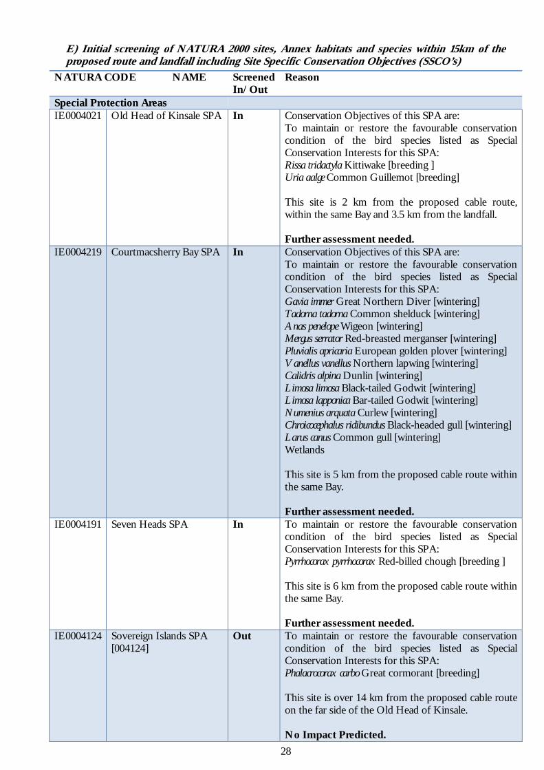
E) Initial screening of NATURA 2000 sites, Annex habitats and species within 15km of the proposed route and landfall including Site Specific Conservation Objectives (SSCO’s)
NATURA CODE NAME Screened In/Out
Reason
Special Protection Areas IE0004021 Old Head of Kinsale SPA In Conservation Objectives of this SPA are:
To maintain or restore the favourable conservation condition of the bird species listed as Special Conservation Interests for this SPA: Rissa tridactyla Kittiwake [breeding ] Uria aalge Common Guillemot [breeding] This site is 2 km from the proposed cable route, within the same Bay and 3.5 km from the landfall. Further assessment needed.
IE0004219 Courtmacsherry Bay SPA In Conservation Objectives of this SPA are: To maintain or restore the favourable conservation condition of the bird species listed as Special Conservation Interests for this SPA: Gavia immer Great Northern Diver [wintering] Tadorna tadorna Common shelduck [wintering] Anas penelope Wigeon [wintering] Mergus serrator Red-breasted merganser [wintering] Pluvialis apricaria European golden plover [wintering] Vanellus vanellus Northern lapwing [wintering] Calidris alpina Dunlin [wintering] Limosa limosa Black-tailed Godwit [wintering] Limosa lapponica Bar-tailed Godwit [wintering] Numenius arquata Curlew [wintering] Chroicocephalus ridibundus Black-headed gull [wintering] Larus canus Common gull [wintering] Wetlands This site is 5 km from the proposed cable route within the same Bay. Further assessment needed.
IE0004191 Seven Heads SPA
In To maintain or restore the favourable conservation condition of the bird species listed as Special Conservation Interests for this SPA: Pyrrhocorax pyrrhocorax Red-billed chough [breeding ] This site is 6 km from the proposed cable route within the same Bay. Further assessment needed.
IE0004124 Sovereign Islands SPA [004124]
Out To maintain or restore the favourable conservation condition of the bird species listed as Special Conservation Interests for this SPA: Phalacrocorax carbo Great cormorant [breeding] This site is over 14 km from the proposed cable route on the far side of the Old Head of Kinsale. No Impact Predicted.

29
NATURA CODE NAME Screened In/Out
Reason
Special Areas of Conservation
IE00001230 Courtmacsherry Estuary SAC
In Qualifying Interests 1130 Estuaries 1140 Mudflats and sandflats not covered by seawater at low tide 1210 Annual vegetation of drift lines 1220 Perennial vegetation of stony banks 1310 Salicornia and other annuals colonising mud and sand 1330 Atlantic salt meadows (Glauco-Puccinellietalia maritimae) 1410 Mediterranean salt meadows (Juncetalia maritimi) 2110 Embryonic shifting dunes 2120 Shifting dunes along the shoreline with Ammophila arenaria (white dunes) 2130 Fixed coastal dunes with herbaceous vegetation (grey dunes)*. * indicates a priority habitat under the Habitats Directive This site is 6 km from the proposed cable route within the same Bay. Further assessment needed.
Additional Annex I Habitats, Annex II and IV Species in the vicinity of the Cable Laying
NATURA CODE NAME Screened In/Out
Reason
Annex I Habitat 1170 Reef In The proposed route crosses reef areas in
inshore areas. Further assessment is required.
2130 Fixed dunes (grey dunes)* In An area of fixed dune is located in the vicinity of the landfall area. Further assessment is required.
Marine Annex IV Species Cetaceans in addition harbour
porpoises and bottle-nosed dolphins are also listed under Annex II
In Cetaceans have been recorded in the vicinity of the cable lay. Further assessment is required.
Marine Annex II/V Species 1365 Harbour (Common) Seal In Harbour seals are distributed within the
area of the proposed route. The site is not a haul out or breeding area. Further assessment is required.
1364 Grey Seal In Grey seals are distributed within the area of the proposed route. The site is not a haul out or breeding area. Further assessment is required.
1106 Atlantic Salmon In Atlantic salmon are found in the Argideen River and would pass through Courtmacsherry Bay

30
Impacts on Site Specific Conservation Objectives and Annex Habitats 1) Conservation Objectives and overall status of species and habitats in Old Head of
Kinsale SPA (IE0004021).
Conservation Objectives To maintain or restore the favourable conservation condition of the bird species listed as Special Conservation Interests for this SPA:
Rissa tridactyla Kittiwake [breeding] Uria aalge Common Guillemot [breeding]
Site characteristics2 “The Old Head is a 5 km long headland formed of steeply inclined beds of rock. These are of geological interest as they show a cross section of the transition between the Devonian and Carboniferous periods. The SPA site comprises a section of the cliffs on the western side of the narrow isthmus leading to the Head. These are vertical rock cliffs providing optimum habitat for ledge nesting seabirds. Maritime grassland and heath occurs above the steep cliffs though part of this has now been converted to amenity grassland as a golf course. The site includes the adjacent marine area to a distance of 200 m from cliff base.
Quality and Importance The Old Head holds the largest seabird colony on the south coast between the Bull Rock and the Saltee Islands. It supports nationally important populations of Rissa tridactyla and Uria aalge (c.3% of the national totals of each), as well as smaller numbers of Fulmarus glacilis and Alca torda. Populations of both Rissa tridactyla and Alca torda have declined since the late 1980s. Pyrrhocorax pyrrhocorax and Falco peregrinus, which breed elsewhere on the Head, are regularly seen within the SPA site. The seabird populations are well monitored and the site is a designated Refuge for Fauna.
Vulnerability There are no threats to the cliff habitat used by the breeding seabirds. The reason for recent declines in the populations of Rissa tridactyla and Alca torda is not known but this may be due to changes in the availability of food items. Conversion of part of the SPA to a golf course could affect feeding potential for the local population of Pyrrhocorax pyrrhocorax.” Based on the “Action Plan for Marine and Sea Cliff Birds in Ireland 2011-2020 (Birdwatch Ireland 2010) there has been a 11% increase in the breeding population of Kittiwakes (36,100 pairs) and a 181% increase in breeding population of Guillemot (236,654 birds) between 1969 & 2002.”
Impact on SSCO’s Guillemots are amber-listed in Ireland due to majority of guillemots breeding at less than ten sites. The European population has been evaluated as Secure. They are present all year with breeding in the summer months. They come ashore to nest from May onwards and colonies are deserted by the first week in August. They nest on cliff ledges, often in large colonies. As a result, nesting of guillemots will not be taking place in April, during the Horizontal Directional Drill operations, but may be nesting during the time of the main lay in July.
The mouth of Kinsale Harbour lies 7 km to the NW of this SPA. This port has regular visits from cruise liners, large sailing vessels and yachts in addition to numerous boat charters and hiring companies. For example from May to September 2011 there were 23 shore excursions from cruise liners (www.kinsale.ie). Main lay operations will be over 2.5km from the SPA.
As part of the mitigation measures and to reduce any potential impact on breeding birds the main lay vessel must at all times stay within 500m of the proposed cable route i.e. maintaining a minimum of 2km from the SPA. Noise generated from the vessel will be restricted to main engines and winches. It is therefore seen that with the precedence of significant large vessel traffic in the area, due to the presence of Kinsale Harbour and that the closest the vessel will be to the SPA is 2km that there will be no significant impact on the conservation objectives of this SPA i.e. breeding populations of Kittiwakes and Guillemots.
2 NATURA 2000 Standard Data Form

31
2) Conservation Objectives and overall status of species and habitats in Courtmacsherry Bay SPA (IE 0004219).
Conservation Objectives Objective: To maintain or restore the favourable conservation condition of the bird species listed as Special Conservation Interests for this SPA:
Gavia immer [wintering] Tadorna tadorna [wintering] Anas penelope [wintering] Mergus serrator [wintering] Pluvialis apricaria [wintering] Vanellus vanellus [wintering] Calidris alpina [wintering] Limosa limosa [wintering] Limosa lapponica [wintering] Numenius arquata [wintering] Chroicocephalus ridibundus [wintering] Larus canus [wintering] Wetlands
Site Characteristics As outlined in the Site Synopsis the site, which is largely estuarine in nature, consists of the drowned valley of the Argideen River which is now filled with sediments, resulting in extensive mudflats and areas of saltmarsh. The estuary of the Kilbrittain River in the north-east of the site holds an area of well-developed saltmarsh. The seaward boundary for the site stretches from Coolmain Point to Barry Point, and includes Coolmain Bay and Broadstrand Bay. Most of the mudflats are unvegetated, although in places Cord-grass (Spartina anglica) occurs. Saltmarsh has developed in a number of areas, the abundant species mostly being Sea Club-rush (Scirpus maritimus), Common Scurvygrass (Cochlearia officinalis), Sea Arrowgrass (Triglochin maritima), Sea Plantain (Plantago maritima), Thrift (Armeria maritima) and Saltmarsh Rush (Juncus gerardi). Quality and Importance The site is of ornithological importance for the wintering waders and wildfowl that feed on the mudflats. It supports internationally important numbers of Black-tailed Godwit (506 - figures given here and below are mean peaks for the five winters in the period 1995/96 to 1999/00), as well as nationally important numbers of a further eleven species, i.e. Great Northern Diver (27), Shelduck (175), Wigeon (934), Red-breasted Merganser (63), Golden Plover (5,759), Lapwing (2,713), Dunlin (1,353), Bar-tailed Godwit (182), Curlew (1,357), Black-headed Gull (2,727) and Common Gull (2,226). Other species which occur include Oystercatcher (610), Redshank (227) and Greenshank (26). Courtmacsherry Bay SPA is an important site for wintering birds. It holds internationally important numbers of Black-tailed Godwit and nationally important numbers of a further eleven species, including three that are listed on Annex I of the E.U. Birds Directive, i.e. Great Northern Diver, Golden Plover and Bar-tailed Godwit. Impact on SSCO’s The conservation objectives of this site are primarily associated with over-wintering birds. The HDD will take place in April 2015 when many of the species will have left or will be leaving the site. The site is 5km from the proposed activities. Sound levels of the HDD machinery as previously indicated should be imperceptible, particularly as the estuary is surrounded by a busy road. The integrity of the wetlands is not expected to be impacted by the HDD or the main lay operations.

32
3) Conservation Objectives and overall status of species and habitats in Seven Heads SPA (IE0004191)
Conservation Objectives To maintain or restore the favourable conservation condition of the bird species listed as Special Conservation Interests for this SPA:
Pyrrhocorax pyrrhocorax Red Billed Chough [breeding ] Site Characteristics As outlined in the Site Synopsis Sea cliffs are the predominant habitat of the site; these occur along its length and are generally well-vegetated by a suite of typical sea cliff species. Above the cliffs areas of heath, improved grassland, unimproved wet and dry grassland, freshwater marsh and arable land occur. Quality and Importance The site supports an important population of breeding Chough, a Red Data Book species that is listed on Annex I of the E.U. Birds Directive; 13 breeding pairs were recorded from the site in the 1992 survey and 15 in the 2002/03 survey. In addition, flocks of up to 47 birds were noted in the 1992 survey and up to 25 in the 2002/03 survey. Impact on SSCO’s At its nearest point this site is 6km from the cable route and 7.6 km from the HDD site. During the time of the HDD the breeding season may have commenced for the Chough and the species would be sensitive to disturbance. The noise levels at this location from HDD operations would be estimated to be < 10db. Given the proximity of the site to background noise including wave action and wind on this exposed site, noise levels created by the HDD operation would be imperceptible at this location and would not impact on breeding activity of Pyrrhocorax pyrrhocorax . During main lay operations in July the breeding season would be ongoing with possibly peak numbers of Pyrrhocorax pyrrhocorax being present on site. As part of the mitigation measures and to reduce any potential impact on breeding birds the main lay vessel will stay within 500m of the proposed cable route and noise generated from the vessel will be restricted to main engines and winches. This site is a minimum 6km from the cable route. Given the precedence of significant large vessel traffic in the area (due to the presence of Kinsale Harbour) and as the closest the vessel will be to the SPA is 5.5 km, there will be no significant impact on the conservation objectives of this SPA.

33
4) Conservation Objectives and overall status of species and habitats in Courtmacsherry Estuary SAC (IE0001230)
Conservation Objectives The maintenance of habitats and species within Natura 2000 sites at favourable conservation condition :
1130 Estuaries 1140 Mudflats and sandflats not covered by seawater at low tide 1210 Annual vegetation of drift lines 1220 Perennial vegetation of stony banks 1310 Salicornia and other annuals colonising mud and sand 1330 Atlantic salt meadows (Glauco-Puccinellietalia maritimae) 1410 Mediterranean salt meadows (Juncetalia maritimi) 2110 Embryonic shifting dunes 2120 Shifting dunes along the shoreline with Ammophila arenaria (white dunes) 2130 Fixed coastal dunes with herbaceous vegetation (grey dunes)*.
* indicates a priority habitat under the Habitats Directive Site Characteristics This site is located in west Cork, some 12 km south of Bandon and immediately east of the village of Timoleague. The estuary consists of the drowned valley of the Argideen River, which is now filled with sediments, resulting in an extensive area of mudflats. The site contains a complex of coastal habitats, including ten which are listed in the E.U. Habitats Directive. Quality and Importance As outlined in the Site Synopsis Courtmacsherry Estuary is an important site for the complex of coastal habitats found there, including ten listed on Annex I of the E.U. Habitats Directive, and for the large numbers of birds that use the area. The presence of rare and scarce plant species adds further interest and value to the site. Please note that this SAC overlaps with Courtmacsherry Bay SPA. Full details of the site synopsis can be seen in Appendix III. Impact on SSCO’s Courtmacsherry SAC is 6.7km from the cable route. The impacts of the HDD and cable lay on habitats will be very localised and short lived, solely in the immediate vicinity of the cable route. These impacts would not be expected to alter the size or the conservation integrity of terrestrial or intertidal habitats in an SAC, at such a distance from the cable route.

34
5) Additional Annex I Habitats, Annex II and IV Species in the vicinity of the Cable Laying Annex I Habitat- 1170 Reef
The proposed route of the fibre optic cable crosses areas of reef habitat within the Irish 12nm limit. Figure 8 (p19) shows the proposed route of the cable within the 12nm limit with backscatter data, acquired by the INFOMAR Project and sidescan coverage of the cable route corridor. A strong correlation is seen between the sidescan and backscatter data in relation to the reef outcrops (dark areas). This figure also shows the proposed methodology for cable laying.
Horizontal Directional Drill operations will take place from the landfall to 1m BCD in order to avoid the intertidal/ shallow sublittoral reef seen in Figure 3. Drilling will take place through the bedrock beneath the surface and will not impact on the integrity of the reef habitat. It should be noted that during fieldwork thin patches of biogenic reef forming Sabellaria alveolata were noted in the intertidal reef area. This site is moderately exposed with strong wave action and coarse sands, providing the correct conditions for growth. However, the areas occupied by Sabellaria alveolata were thin (1cm high). As indicated in the methodology the HDD will be rinsed prior to break through into the marine environment. No drill fluids will enter the marine environment. No machinery will be placed on the intertidal sand or reef areas. As a result no impact is foreseen on the population of Sabellaria alveolata.
As seen in Plate 1 (p17) a protective cast iron covering will be placed over the cable by divers in the inshore reef area (~10m). Localised short-term disturbance will occur as divers fit the cast iron split shells to the cable due to kneeling/finning etc. Additional impact will occur by the presence of the cast iron pipe on 36m2 of reef, assuming that the entire width (9cm) and length (400m) of pipe will be on the geogenic reef. The presence of the pipe will not alter the structural integrity of the reef and is designed to biofoul. A change in flora and fauna may be seen in the immediate vicinity of the pipe due to compression and shadowing effects caused by the presence of the pipe. Removal of the pipe at decommissioning, if required, would be expected to result in the full restoration of the flora and fauna.
An additional area (0.9km) of bedrock with sand pockets is located at approximately 60-70m BCD. At present it is felt that plough burial is achievable here, but failing this surface laying will be used. In this area, the proposed methodology in the subtidal reef/bedrock where burial is not possible is to surface lay the double amour cable on the seabed in such a way that there is no slack in the cable to form loops or kinks, but there is sufficient cable deployed to closely follow the contours of the seafloor. This is done by utilising cable slack management techniques during the surface laying operations. Onboard engineers will ensure that there is enough cable to allow for the conforming of the system to the various reef areas on the seabed as identified during the survey operations. In the sand areas between the reef the cable will be buried by means of a ROV with a water jet system, and in the larger sand areas the cable will be laid by plough. The proposed methodology has been devised to eliminate the potential for damage to the structural and biotic integrity of reef areas by the dragging the plough through this habitat, while maintaining sufficient cover for the cable to avoid damage either by fishing/ storms etc. This method of burial in sand pockets is particularly important in the deeper reef areas where the tidal streams are strong. Based on the MSFD predicted habitat data and the Admiralty chart no additional reef areas are seen out to the 12nm limit.
Cable laying methodology in reef areas. (Source TE Subcom)
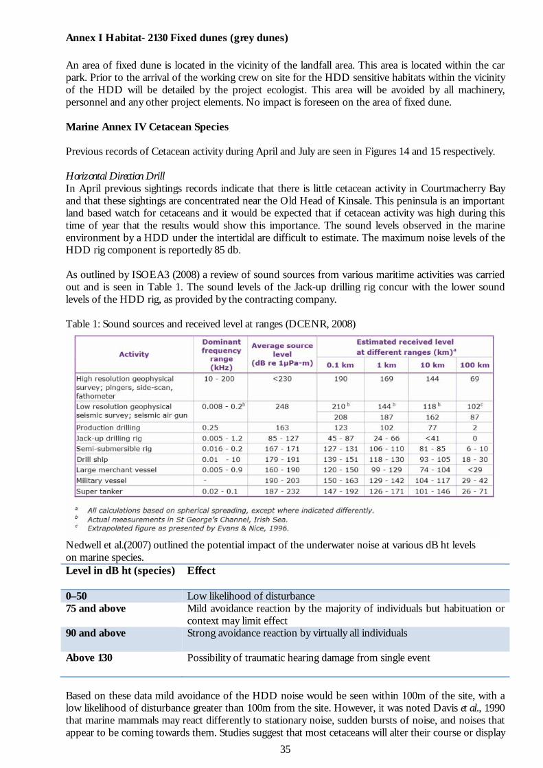
35
Annex I Habitat- 2130 Fixed dunes (grey dunes)
An area of fixed dune is located in the vicinity of the landfall area. This area is located within the car park. Prior to the arrival of the working crew on site for the HDD sensitive habitats within the vicinity of the HDD will be detailed by the project ecologist. This area will be avoided by all machinery, personnel and any other project elements. No impact is foreseen on the area of fixed dune. Marine Annex IV Cetacean Species Previous records of Cetacean activity during April and July are seen in Figures 14 and 15 respectively. Horizontal Direction Drill In April previous sightings records indicate that there is little cetacean activity in Courtmacherry Bay and that these sightings are concentrated near the Old Head of Kinsale. This peninsula is an important land based watch for cetaceans and it would be expected that if cetacean activity was high during this time of year that the results would show this importance. The sound levels observed in the marine environment by a HDD under the intertidal are difficult to estimate. The maximum noise levels of the HDD rig component is reportedly 85 db. As outlined by ISOEA3 (2008) a review of sound sources from various maritime activities was carried out and is seen in Table 1. The sound levels of the Jack-up drilling rig concur with the lower sound levels of the HDD rig, as provided by the contracting company. Table 1: Sound sources and received level at ranges (DCENR, 2008)
Nedwell et al.(2007) outlined the potential impact of the underwater noise at various dB ht levels on marine species. Level in dB ht (species) Effect
0–50 Low likelihood of disturbance 75 and above Mild avoidance reaction by the majority of individuals but habituation or
context may limit effect 90 and above
Strong avoidance reaction by virtually all individuals
Above 130
Possibility of traumatic hearing damage from single event
Based on these data mild avoidance of the HDD noise would be seen within 100m of the site, with a low likelihood of disturbance greater than 100m from the site. However, it was noted Davis et al., 1990 that marine mammals may react differently to stationary noise, sudden bursts of noise, and noises that appear to be coming towards them. Studies suggest that most cetaceans will alter their course or display

36
avoidance reactions to a noise that appears to be moving directly towards them. Stationary noises, such as drilling and production noises, outwith an immediate zone of discomfort to the animal, seem to have a lesser effect in disturbing migration patterns and animal feeding, although data and observations are limited. Main Cable Lay As seen in Figure 15 species recorded in the area during July include harbour porpoise, common dolphin, minke whale, “other” whale, fin whale and one sighting of a humpback whale. As previously outlined, ploughing and the laying of the cable is done passively, where the plough is pulled behind the ship and the cable is laid immediately behind the plough. Progress is slow with the vessel travelling at 0.3-1kn and no additional machinery is required. The sound generated from the device has been noted as being similar to dredging activities. As a result no acoustic impact is foreseen with this device. The cable route is located near Kinsale which is a hub for marine leisure activities including cruise liners and is also close to Cork Harbour. As a result significant vessel activity is already seen in the area. The vessel will be travelling at very slow speeds and as a result would not pose a risk to cetaceans. Marine Annex II/V Species Harbour and Grey Seals The proposed cable route is within the distribution range of both Harbour and Grey Seals. However, the beach at Garrettstown is a popular recreational activity area and is not classed as a breeding or haul out site for either seal species. There are no recognised breeding or haul out areas within 15km of the cable route. Migrating fish species Based on IFI (2003), the streams that enter directly into Courtmacsherry Bay, including the stream that enters near Garrettstown Beach, are “not considered to be a significant producer of Salmonids”. However, the Ardigeen River that passes through Timoleague, Courtmacsherry Harbour and then Courtmacsherry Bay, is classed as a “Salmon/seatrout” River. Salmon are not a conservation objective of the Courtmacsherry Estuary SAC and this is the only SAC within this Ardigeen river catchment. As outlined in the South Western River Basin District Rivers Report 2009 “although salmon are present, the Argideen is best known as a sea trout fishery. When conditions are favourable, it is believed to be among the best in Ireland, with stocks improving steadily over the past few years (O’Reilly, 2009)”. Based on this report, the European eel is also present in the river. The outer parts of Courtmacsherry Bay would therefore by used as a migratory route for Salmon, seatrout and eels from the Argideen River. Consultation has taken place with Inland Fisheries Ireland in relation to the laying of the fibre optic cable/HDD and the potential impact on migratory fish species, protected under the Habitats Directive, and of conservation significance that use Courtmacsherry Bay. Inland Fisheries Ireland have stated that they do not foresee a significant impact on migratory and other fish species including Sea Bass and do not require additional mitigation measures to be developed.

37
F) Field Observations at Garrettstown Beach, Co. Cork. During fieldwork, only those features relevant to the proposed cable lay for the fibre optic cable, the potential cumulative effects in relation the installation of the fibre-optic and surrounding impacts, including those above the tidal limit, that may have an adverse effect on the integrity of NATURA 2000 sites, have been considered. An adverse effect on integrity is likely to be one that prevents the site from making the same contribution to favourable conservation status for the relevant features as it did at the time of designation; ‘integrity’ being defined by the European Commission (2000) as relating to the reasons for the site’s designation: “The integrity of a site is the coherence of the site’s ecological structure and function, across its whole area, or the habitats, complex of habitats and / or populations of species for which the site is or will be classified” During field observations, we had particular regard to any sign of the above potential impacts on surrounding SAC’s, SPA’s, NATURA 2000 species and habitats. The cable route within the 12nm limit or the landfall of the cable, does not enter or pass within 2.5km of any NATURA 2000 site (SPA or SAC). A walk over assessment of the landfall area was carried out by Bryan Deegan (Altemar Ltd.) on the 27th October 2014, at low water (spring). Weather conditions were poor with Force 7-8 south-westerly winds and occasional showers. The assessment area included the intertidal area, storm beach and the field behind the car park, identified in Figure 16. Machinery and the small compound area relating to HDD for the duct beneath the reef area will be located in the field at the landward section of the car park as seen in Figure 16 and in Plate 1. This field is a species poor heavily grazed area of improved agricultural grassland that had recently been mown. In the background of Plate 1 is Garrettstown Marsh pNHA. This pNHA is also seen in Plate 2.
Figure 16. Proposed landfall location indication the HDD compound and duct with conservation interests.
HDD Compound
Underground Cable duct
Fixed Dune
pNHA
Intertidal geogenic reef with Sabellaria alveolata

38
. Plate 1. Site location for the HDD compound. (Garrettstown Mash pNHA in the background)
Plate 2. Garrettstown Marsh pNHA. Garrettstown Beach is seen in Plate 3. This beach is moderately exposed. A large storm beach dominates the upper shore with a steep slope of cobbles (inset). At mid tide level mixed sediment is found, with coarse sand and gravel. On the lower shore there is coarse sand, with several areas of bedrock. Dig-overs were carried out on the beach at mid and lower shore and no conspicuous fauna were found, with the exception of numerous Velella velella (By-the-wind sailor) located on the sand blown in by the strong winds. On the western end of the beach a large area of intertidal reef is seen (Plate 4). A thin covering of Sabellaria alveolata (Honeycomb worm) was found occasionally on the intertidal reef area. This is a biogenic reef forming polychaete, of conservation importance (Plate 5). Other species found here included Ulva intestinalis, Corallina officinalis, Fucus vesiculosus, Fucus serratus, Palmaria palmata, Porphyra sp., Lomentaria articulata, Codium sp., Actinia equina, Littorina littorea, Patella vulgata, Nucella lapillus in addition to Haematopus ostralegus feeding amongst the rocks.

39
Plate 3. Garrettstown Beach (Facing South). (Inset: Storm beach)
Plate 4. Garrettstown Beach (Facing North) intertidal reef.

40
Plate 5. Biogenic Reef forming Sabellaria alveolata (Honeycomb worm) in intertidal reef area.
G) Cumulative Impacts “All likely sources of effects arising from the plan or project under consideration should be considered together with other sources of effects in the existing environment and any other effects likely to arise from proposed or permitted plans or projects. These include ex situ as well as in situ plans or projects.” Terrestrial cable Route Once the connection to the existing Eircom network has been made via the beach manhole, the entire route to Cork City will use the existing Eircom underground ducting and follow the existing road networks. The cable will be installed in the existing duct and as a result will have no significant impact on Natura 2000 sites. Existing/Proposed planning applications The Cork County Council online planning system was queried in relation to planning applications in the vicinity of Garrettstown Strand. No new planning applications have been submitted since 2012. There are no foreseen cumulative impacts that will have an impact on Natura 2000 sites or their SSCO’s in association with this project.

41
H) Potential impact and the significance of the impact The potential impact and the significance of the impact of the activity in combination with the other plans and projects for each of the conservation objectives in the screened NATURA 2000 sites are seen in the tables below: Old Head of Kinsale SPA (IE0004021) Qualifying Interest Impact and Significance
Rissa tridactyla Kittiwake [breeding ] Uria aalge Common Guillemot [breeding]
This SPA is 2 km from the proposed cable route, within the same bay and 3.5 km from the landfall area. It is estimated that the loudest noises generated from the HDD at the landfall area will be in the region of 20db at the nearest point of the SPA. The HDD will be carried out in April 2015, prior to the breeding season. The main lay in July 2015 will be carried out during the breeding season. Vessel noise will be restricted to engines and winches only and the main lay vessel will be no closer than 2km from the SPA. There is already precedence for large vessel traffic in the area with cruise liners regularly visiting Kinsale 7km to the NW. No Significant Impact Predicted.
Courtmacsherry Bay SPA (IE0004219) Qualifying Interest Impact and Significance
Gavia immer Great Northern Diver [wintering] Tadorna tadorna Common shelduck [wintering] Anas penelope Wigeon [wintering] Mergus serrator Red-breasted merganser [wintering]Pluvialis apricaria European golden plover [wintering] Vanellus vanellus Northern lapwing [wintering] Calidris alpina Dunlin [wintering] Limosa limosa Black-tailed Godwit [wintering] Limosa lapponica Bar-tailed Godwit [wintering] Numenius arquata Curlew [wintering] Chroicocephalus ridibundus Black-headed gull [wintering] Larus canus Common gull [wintering]
This site is over 5 km from the proposed cable route and HDD site. Overwintering birds may be present during the HDD in April 2015, but will not be present during main lay in July 2015. However, some species listed under the conservation objectives may also have individuals present during the summer months e.g. Common Gull and Black Headed Gull. It is estimated that the noise levels from the loudest element of the HDD will be in the region of 16db at the nearest edge of the SPA. Given that the SPA is surrounded by the R600 and is beside Courtmacsherry with significant ambient noise, noise from the HDD operations should be inaudible and cause no disturbance to over wintering birds, if present during operations. No Significant Impact Predicted.
Wetlands
This habitat does not occur in the vicinity of the proposed cable laying. The proposed cable laying will not impact on this habitat. No Significant Impact Predicted.

42
Seven Heads SPA (IE0004191) Qualifying Interest Impact and Significance
Pyrrhocorax pyrrhocorax Red-billed chough [breeding ]
This site is 6 km from the proposed cable route within the same Bay. . No Significant Impact Predicted.
Courtmacsherry Bay SAC (IE00001230) Qualifying Interest Impact and Significance
1130 Estuaries
1140 Mudflats and sandflats not covered by seawater at low tide
1210 Annual vegetation of drift lines
1220 Perennial vegetation of stony banks
1310 Salcornia and other annuals colonising mud and sand
1330 Atlantic salt meadows (Glauco-Puccinellietalia maritimae)
1410 Mediterranean salt meadows (Juncetalia maritimi)
2110 Embryonic shifting dunes
2120 Shifting dunes along the shoreline with Ammophila arenaria (white dunes)
2130 Fixed coastal dunes with herbaceous vegetation (grey dunes)
The impacts of the HDD and cable lay on habitats will be very localised and short lived, solely in the immediate vicinity of the cable route. These impacts would not be expected to alter the size or the conservation integrity of terrestrial and intertidal habitats in an SAC over 5 km from the proposed cable route and HDD site. No Significant Impact Predicted.
I) Mitigation Measures
1. No hydroacoustics are to be used during the cable lay so as to limit disturbance to cetaceans. 2. The cable lay vessel should at all times be within 500m of the cable lay route in order to minimise
disturbance of breeding birds in the surrounding SPA’s 3. Divers when laying articulated pipe should have due regard for the surrounding reef habitat and
minimise the area impacted.
4. Ecology supervision In order to ensure the integrity of Annex habitats and additional habitats of importance are retained in the vicinity of the planned project, the following is recommended:
a) An ecologist should be onsite for the initial set up of HDD machinery and commencement of drill (Due to the proximity of the pNHA)
b) An aquatic ecologist should be onsite to observe the subtidal breakthrough and ensure that no bentonite escapes into the marine environment.
c) An ecologist should be onsite to observe the making good of site, including back filling of drill pit and removal of machinery (Due to the proximity of the NHA)
d) A MMO should be present during ship cable laying to minimise any impact on cetaceans.
5. Machinery should not be placed on the dune area in the car park, intertidal sand or reef.
6. Additional measures to be carried out during the HDD are outlined in Appendix 5.

43
J) Finding of No Significant Effects Report
Details of project Name and Location of the NATURA 2000 site
IE0004021 Old Head of Kinsale SPA IE0004219 Courtmacsherry Bay SPA IE0004191 Seven Heads SPA IE0004124 Sovereign Islands SPA IE00001230 Courtmacsherry Estuary SAC
Description of the Project Appropriate Assessment Screening for main lay (Foreshore Licence Application) for Hibernia Express trans-Atlantic fibre-optic cable landing in Garrettstown, Co. Cork.
Is the Project directly connected with the management of the NATURA 2000 site?
No
Details of any other projects or plans that together with this project could affect the Natura 2000 site
None
The assessment of significant effects Describe how the project is likely to affect the NATURA 2000 site
Response to consultation N/A Data collected to carry out the assessment Who carried out the assessment Altemar Ltd. Sources of data NPWS website, standard data form,
conservation objectives data, field survey of the site and references outlined in the AA Screening Report.
Explain why the effects are not considered significant
Deemed to be not a significant effect due to the localised nature of impacts. Minor disturbance may occur but mitigation measures are proposed.
Level of assessment completed Stage 1 Screening Where can full results be accessed and reviewed
Overall conclusions No part of this project is within a designated Natura 2000 site. Localised and temporary disturbance will occur in the immediate vicinity of the HDD and cable route, but this will not impact on the SSCO’s of nearby Natura 2000 sites or Annex habitats/species in the vicinity of the planned project. No significant impact is predicted.

44
K) References The following references were used in the preparation of this AA screening report. Department of Environment Heritage and Local Government Circular NPW 1/10 and PSSP 2/10 on
Appropriate Assessment under Article 6 of the Habitats Directive – Guidance for Planning Authorities March 2010.
Appropriate Assessment of Plans and Projects in Ireland: Guidance for Planning Authorities, Department of the Environment, Heritage and Local Government 2009; http://www.npws.ie/publications/archive/NPWS_2009_AA_Guidance.pdf
Managing NATURA 2000 Sites: the provisions of Article 6 of the Habitats Directive 92/43/EEC, European Commission 2000; http://ec.europa.eu/environment/nature/Natura2000/management/docs/art6/provision_of_art6_en.pdf
Assessment of Plans and Projects Significantly Affecting NATURA 2000 Sites: Methodological guidance on the provisions of Article 6(3) and (4) of the Habitats Directive 92/43/EEC; http://ec.europa.eu/environment/nature/Natura2000management/docs/art6/Natura_2000_assess_en.pdf
Guidance document on Article 6(4) of the 'Habitats Directive' 92/43/EEC – Clarification of the concepts of: alternative solutions, imperative reasons of overriding public interest, compensatory measures, overall coherence, opinion of the commission; http://ec.europa.eu/environment/nature/Natura2000/management/docs/art6/guidance_art6_4_en.pdf
Guidance document on the implementation of the birds and habitats directive in estuaries and coastal zones with particular attention to port development and dredging; http://ec.europa.eu/environment/nature/Natura2000/management/docs/guidance_doc.pdf
The Status of EU Protected Habitats and Species in Ireland. http://www.npws.ie/publications/euconservationstatus/NPWS_2007_Conservation_Status_Report.pdf
Killala Bay/Moy Estuary SAC (site code 458) Conservation objectives supporting document -coastal Nedwell, JR, Turnpenny, AWH, Lovell JM, Parvin, S.J., Workman, R., Spinks, J.Al. and Howell, D.
(2007) A validation of the dB ht as a measure of the behavioural and auditory effects of underwater noise. Subacoustech Report No. 54R1231( http://www.subacoustech.com/information/downloads/reports/534R1231.pdf
DCENR(2008), ISOSEA3, Section 7, Impact assessment for seismic activities http://www.dcenr.gov.ie/NR/rdonlyres/E232CDE8-00F2-48C8-95DC-F57ACA339C99/0/1919R004s7Seismicimpacts_f.pdf

45
APPENDCIES
Appendix I: Proposed Natural Heritage Areas within 15km of the proposed route.
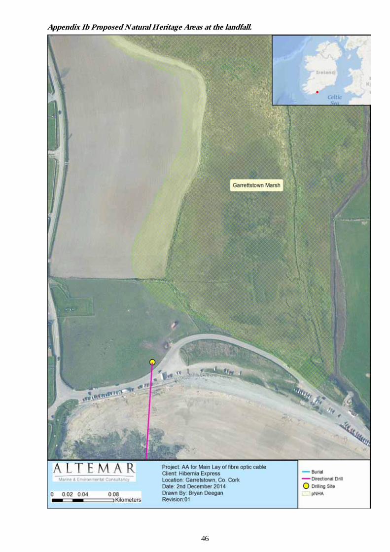
46
Appendix Ib Proposed Natural Heritage Areas at the landfall.

47
Appendix II: Natural Heritage Areas within 15km of the proposed route.

48
Appendix III: Site Synopses of SAC’s and SPA’s within 15 km of proposed fibre-optic cable and landing site SITE NAME: OLD HEAD OF KINSALE SPA. SITE CODE: 004021 The Old Head is a 5 km long headland formed of steeply inclined beds of rock. These show a cross section of the transition between the Devonian and Carboniferous periods and so have considerable interest from a geological point of view. The site comprises a section of the cliffs on the western side of the narrow isthmus leading to the Head. These are vertical rock cliffs providing optimum habitat for ledge nesting seabirds. Maritime grassland and heath occurs above the steep cliffs though part of this has now been converted to amenity grassland as a golf course. The cliff-top vegetation is characterised by such species as Autumn Gorse (Ulex gallii), Bell Heather ( Erica cinerea), Bent Grasses (Agrostis spp.) and Heath Bedstraw ( Galium saxatile), with Sea Campion (Silene maritima), Thrift (Ameria maritima), Wood Sage (Teucrium scorodonia) and Burnet Rose (Rosa pimpinellifolia) also present. The site includes a 500 m seaward extension, where the seabirds forage, rest and socialise. The site is a Special Protection Area (SPA) under the E.U. Birds Directive, of special conservation interest for the following species: Kittiwake and Guillemot. The Old Head is the largest seabird colony on the south coast between the Bull Rock and the Saltee Islands. It supports nationally important populations of Kittiwake (951 pairs in 2001) and Guillemot (3,477 individuals in 2001), as well as smaller numbers of Fulmar (37 pairs), Shag (26 pairs), Herring Gull (11 pairs) and Razorbill (59 occupied sites). The populations of Kittiwake and Razorbill have declined since the late 1980s for reasons unclear but perhaps due to depleted prey stocks. Chough and Peregrine, which breed elsewhere on the Head, are regularly seen within the site. The seabird populations are well monitored. The site is a designated Refuge for Fauna. SITE NAME: COURTMACSHERRY BAY SPA SITE CODE: 004219 Courtmacsherry Bay SPA is located approximately 12 km south of Bandon and immediately east of the village of Timoleague in west Co. Cork. The site, which is largely estuarine in nature, consists of the drowned valley of the Argideen River which is now filled with sediments, resulting in extensive mudflats and areas of saltmarsh. The estuary of the Kilbrittain River in the north-east of the site holds an area of well-developed saltmarsh. The seaward boundary for the site stretches from Coolmain Point to Barry Point, and includes Coolmain Bay and Broadstrand Bay. Most of the mudflats are unvegetated, although in places Cord-grass (Spartina anglica) occurs. Saltmarsh has developed in a number of areas, the abundant species mostly being Sea Club-rush (Scirpus maritimus), Common Scurvygrass (Cochlearia officinalis), Sea Arrowgrass (Triglochin maritima), Sea Plantain (Plantago maritima), Thrift (Armeria maritima) and Saltmarsh Rush (Juncus gerardi). The site is a Special Protection Area (SPA) under the E.U. Birds Directive, of special conservation interest for the following species: Great Northern Diver, Shelduck, Wigeon, Red-breasted Merganser, Golden Plover, Lapwing, Dunlin, Black-tailed Godwit, Bar-tailed Godwit, Curlew, Black-headed Gull and Common Gull. The E.U. Birds Directive pays particular attention to wetlands, and as these form part of this SPA, the site and its associated waterbirds are of special conservation interest for Wetland & Waterbirds. The site is of ornithological importance for the wintering waders and wildfowl that feed on the mudflats. It supports internationally important numbers of Black-tailed Godwit (506 - figures given here and below are mean peaks for the five winters in the period 1995/96 to 1999/00), as well as nationally important numbers of a further eleven species, i.e. Great Northern Diver (27), Shelduck (175), Wigeon (934), Red-breasted Merganser (63), Golden Plover (5,759), Lapwing (2,713), Dunlin (1,353), Bar-tailed Godwit (182), Curlew (1,357), Black-headed Gull (2,727) and Common Gull (2,226). Other species which occur include Oystercatcher (610), Redshank (227) and Greenshank (26). Courtmacsherry Bay SPA is an important site for wintering birds. It holds internationally important numbers of Black-tailed Godwit and nationally important numbers of a further eleven species, including three that are listed on Annex I of the E.U. Birds Directive, i.e. Great Northern Diver, Golden Plover and Bar-tailed Godwit.
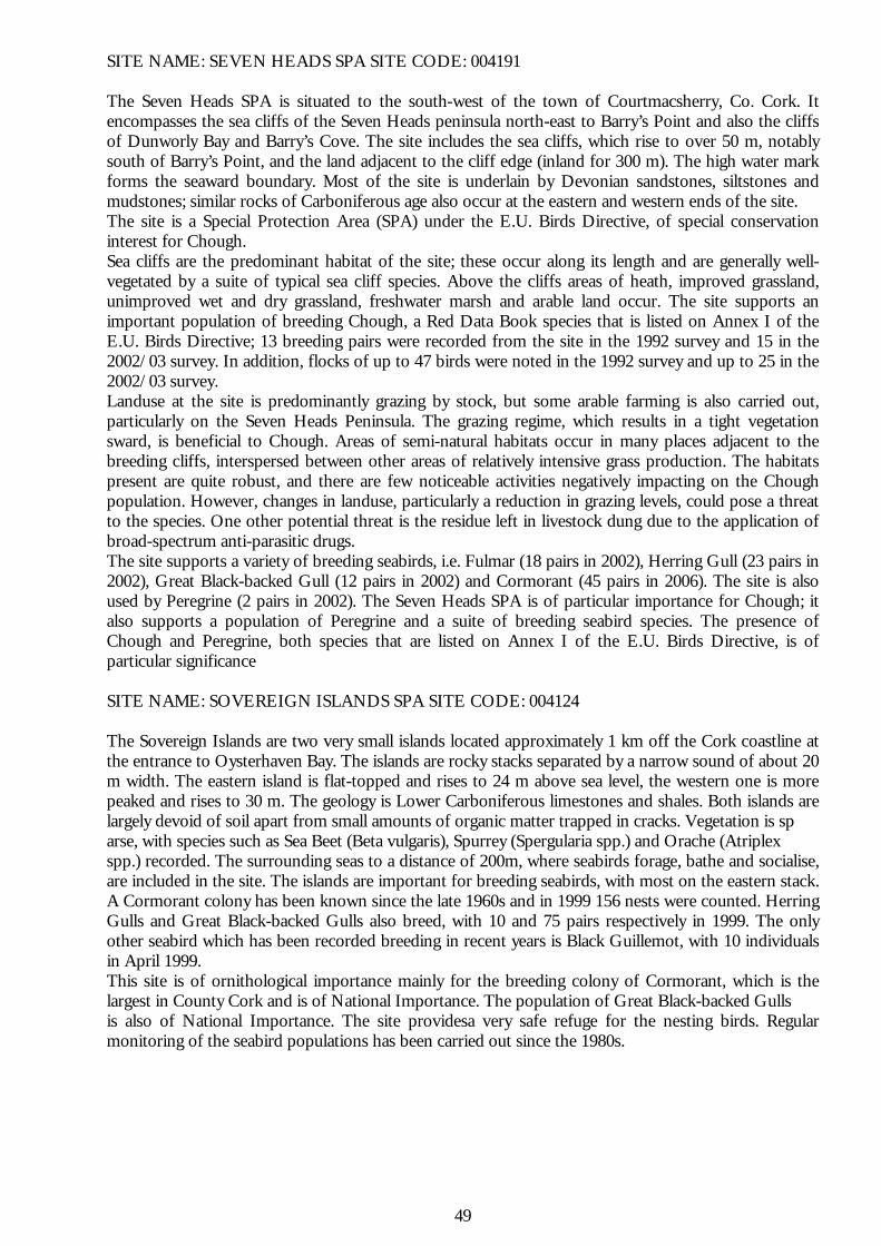
49
SITE NAME: SEVEN HEADS SPA SITE CODE: 004191 The Seven Heads SPA is situated to the south-west of the town of Courtmacsherry, Co. Cork. It encompasses the sea cliffs of the Seven Heads peninsula north-east to Barry’s Point and also the cliffs of Dunworly Bay and Barry’s Cove. The site includes the sea cliffs, which rise to over 50 m, notably south of Barry’s Point, and the land adjacent to the cliff edge (inland for 300 m). The high water mark forms the seaward boundary. Most of the site is underlain by Devonian sandstones, siltstones and mudstones; similar rocks of Carboniferous age also occur at the eastern and western ends of the site. The site is a Special Protection Area (SPA) under the E.U. Birds Directive, of special conservation interest for Chough. Sea cliffs are the predominant habitat of the site; these occur along its length and are generally well-vegetated by a suite of typical sea cliff species. Above the cliffs areas of heath, improved grassland, unimproved wet and dry grassland, freshwater marsh and arable land occur. The site supports an important population of breeding Chough, a Red Data Book species that is listed on Annex I of the E.U. Birds Directive; 13 breeding pairs were recorded from the site in the 1992 survey and 15 in the 2002/03 survey. In addition, flocks of up to 47 birds were noted in the 1992 survey and up to 25 in the 2002/03 survey. Landuse at the site is predominantly grazing by stock, but some arable farming is also carried out, particularly on the Seven Heads Peninsula. The grazing regime, which results in a tight vegetation sward, is beneficial to Chough. Areas of semi-natural habitats occur in many places adjacent to the breeding cliffs, interspersed between other areas of relatively intensive grass production. The habitats present are quite robust, and there are few noticeable activities negatively impacting on the Chough population. However, changes in landuse, particularly a reduction in grazing levels, could pose a threat to the species. One other potential threat is the residue left in livestock dung due to the application of broad-spectrum anti-parasitic drugs. The site supports a variety of breeding seabirds, i.e. Fulmar (18 pairs in 2002), Herring Gull (23 pairs in 2002), Great Black-backed Gull (12 pairs in 2002) and Cormorant (45 pairs in 2006). The site is also used by Peregrine (2 pairs in 2002). The Seven Heads SPA is of particular importance for Chough; it also supports a population of Peregrine and a suite of breeding seabird species. The presence of Chough and Peregrine, both species that are listed on Annex I of the E.U. Birds Directive, is of particular significance SITE NAME: SOVEREIGN ISLANDS SPA SITE CODE: 004124 The Sovereign Islands are two very small islands located approximately 1 km off the Cork coastline at the entrance to Oysterhaven Bay. The islands are rocky stacks separated by a narrow sound of about 20 m width. The eastern island is flat-topped and rises to 24 m above sea level, the western one is more peaked and rises to 30 m. The geology is Lower Carboniferous limestones and shales. Both islands are largely devoid of soil apart from small amounts of organic matter trapped in cracks. Vegetation is sp arse, with species such as Sea Beet (Beta vulgaris), Spurrey (Spergularia spp.) and Orache (Atriplex spp.) recorded. The surrounding seas to a distance of 200m, where seabirds forage, bathe and socialise, are included in the site. The islands are important for breeding seabirds, with most on the eastern stack. A Cormorant colony has been known since the late 1960s and in 1999 156 nests were counted. Herring Gulls and Great Black-backed Gulls also breed, with 10 and 75 pairs respectively in 1999. The only other seabird which has been recorded breeding in recent years is Black Guillemot, with 10 individuals in April 1999. This site is of ornithological importance mainly for the breeding colony of Cormorant, which is the largest in County Cork and is of National Importance. The population of Great Black-backed Gulls is also of National Importance. The site providesa very safe refuge for the nesting birds. Regular monitoring of the seabird populations has been carried out since the 1980s.

50
SITE NAME: COURTMACSHERRY ESTUARY SAC SITE CODE: 001230 This site is located in west Cork, some 12 km south of Bandon and immediately east of the village of Timoleague. The estuary consists of the drowned valley of the Argideen River, which is now filled with sediments, resulting in an extensive area of mudflats. The site contains a complex of coastal habitats, including ten which are listed in the E.U. Habitats Directive. The site is a Special Area of Conservation (SAC) selected for the following habitats and/or species listed on Annex I / II of the E.U. Habitats Directive (* = priority; numbers in brackets are Natura 2000 codes):
[1130] Estuaries [1140] Tidal Mudflats and Sandflats [1210] Annual Vegetation of Drift Lines [1220] Perennial Vegetation of Stony Banks [1310] Salicornia Mud [1330] Atlantic Salt Meadows [1410] Mediterranean Salt Meadows [2110] Embryonic Shifting Dunes [2120] Marram Dunes (White Dunes) [2130] Fixed Dunes (Grey Dunes)*
The greater part of this estuary site is mudflat and tidal channels, but three rivers flow into the site and areas of fresh- and saltmarsh are found. Most of the mudflat at Courtmacsherry is unvegetated, although in places cord-grass (Spartina sp.) occurs. Saltmarsh has developed in a number of areas, with the most abundant species being Sea Club-rush (Scirpus maritimus), Common Scurvygrass (Cochlearia officinalis), Sea Arrowgrass (Triglochin maritima), Sea Plantain (Plantago maritima), Thrift (Armeria maritima) and Saltmarsh Rush (Juncus gerardi). On the outer edges such species as Greater Sea-spurrey (Spergularia media), Lesser Sea-spurrey (S. marina) and Lax-flowered Sea-lavender (Limonium humile) occur, while on their landward edge the saltmarshes frequently support Creeping Bent (Agrostis stolonifera), Red Fescue (Festuca rubra), Silverweed (Potentilla anserina), Soft Rush (Juncus effusus), Common Sorrel (Rumex acetosa) and others. A particularly well-developed and intact saltmarsh occurs at Garranefeen Strand. Tideline communities of Sea Rocket (Cakile maritima) and oraches (Atriplex spp.), including Grass-leaved Orache (A. littoralis), are noted from this site. In stony areas east of Courtmacsherry the uncommon Sea-kale (Crambe maritima) occurs, and Yellow Horned-poppy (Glaucium flavum) has also been recorded. Glasswort (Salicornia spp.) communities have been recorded from Garranefeen inlet. The site also supports small but interesting sand dune systems. Embryonic dunes occur in a number of places, including Garranefeen, Flaxford Strand and near Courtmacsherry, and the species Sand Couch (Elymus farctus) occurs. Marram dunes are well developed on the eastern spit at Garranefeen inlet. Species present include Sea Bindweed (Calystegia soldanella), Sea-spurge (Euphorbia paralias) and Sand Couch. Fixed dunes are not particularly well developed at this site, but where present, support species such as Red Fescue, Common Restharrow (Ononis repens), Kidney Vetch (Anthyllis vulneraria), Pyramidal Orchid (Anacamptis pyramidalis) and Lady’s Bedstraw (Galium verum). The site also includes small areas of sand dune, sandy and shingle beaches, reedbeds of Common Reed (Phragmites australis), scrub, dry grassland, and areas of both wet and dry semi-natural broadleaved woodland, parts of which are dominated by oak (Quercus sp.). The presence of some rare and scarce plant species at the site is noteworthy. The rare Red Data Book species Sea-kale occurs on shingle and the scarce grass, Tor-grass (Brachypodium pinnatum), has been recorded on cliffs between Broadstrand and Wood Point. The site is of ornithological importance for the many waders and wildfowl that feed on the mud- and sandflats. The winter flocks of Golden Plover (2,600) and Black-Tailed Godwit (110) constitute nationally important numbers, and at least nine other species occur in numbers which are significant for the region - Wigeon (58), Mallard (69), Red-breasted Merganser (18), Oystercatcher (162), Lapwing (629), Dunlin (215), Bar-tailed Godwit (178), Curlew (731) and Redshank (139). Although these figures are the average peaks of 4 counts between 1984/85 and 1986/87, at times the numbers present far exceed those given. For example, in January 1992, 5,800 Golden Plover, 671 Wigeon, 731 Dunlin and 456 Oystercatchers were present. The spread of cord-grass on parts of the mudflats poses a threat to the quality of the area for feeding birds, and pollution is an ever-present threat in such a wetland. Courtmacsherry Estuary is an important site for the complex of coastal habitats found there, including ten listed on Annex I of the E.U. Habitats Directive, and for the large numbers of birds that use the area. The presence of rare and scarce plant species adds further interest and value to the site.

51
Appendix IV HDD Contingency Procedures The following plans will be utilized if necessary. Pollution Measures 1.1 Frac-out Contingency Plan Maritech will be equipped with a tracked hydraulic excavator, straw or hay bales, stakes to secure bails, silt fence, sand bags, shovels, pumps, and any other materials or equipment necessary to contain and clean up inadvertent releases. Ancillary items that will be readily available during drilling operations include: a light tower in case cleanup operations are needed after dark, a boat with relevant safety equipment during the crossing of large water bodies, and flexible plastic piping for potential mitigation where small creeks or drainages are involved. 1.2 Fracture Detection The most obvious signs of a frac-out are the visible pooling of drilling mud on the surface, a sudden decease in mud volume returns during drilling operations, or loss in drilling mud pump pressure. Drilling personnel will observe the volume of drilling fluid return and immediately report reductions to the Engineer In Charge. The mud system operator will monitor actual drilling fluid volumes from the pumps and the return flow from the borehole. The operator will alert the on-site personnel if there is a significant variance. In the event of partial circulation loss, pumping of drilling fluid may be reduced to reduce pressure applied to native formation materials. 1.3 Corrective Actions for an Inadvertent Release In the event of an inadvertent release to the surface at locations other than the borehole location, the following actions will be taken:
If the release is large, mud circulation will cease immediately. If the spill is small to moderate, the contractor will continue circulation in order to maintain pressure in the hole.
Maintaining circulation will also be necessary if the native material does not have the frictional characteristics necessary to maintain hole stability without the presence of mud provided under pressure.
In all cases, the contractor will also proceed as follows: Contain any drilling fluid that has surfaced. Notify all on-site representatives. Reduce circulation pressure and evaluate the circumstances leading to circulation loss to
determine if the fracture can be sealed. Thicken the drilling fluid to attempt to seal off the location of the release as reasonably
practical.
1.4 Containment of Drilling Fluid Release Immediately following the detection of the inadvertent drilling fluid release, containment and cleanup operations shall commence. For releases on land, Contractor shall use straw bales, silt fences, sand bags and earth berms to prevent fluid from migrating or flowing from the immediate area of the discharge. If the volume released is too small for containment measures or, if the release occurs in an environmentally sensitive area where release of containments can cause additional damage, the receiving area will be allowed to dry naturally. If there is a threat to a sensitive resource, or a threat to public safety, HDD activities will cease immediately until a plan to proceed is discussed. Other containment measures include the following:
Additional berms may be constructed around the release area as directed by the Engineer In Charge to prevent release of materials into the adjacent water body.
If the amount of fluid released is large enough to prevent practical collection, the affected area will be diluted with fresh water and allowed to dry. Measures will be implemented (berm, silt fence, and/or hay bale installation) to prevent silt laden water from flowing into the water body.
If hand tools cannot contain a small on-land release, small collection sumps may be constructed to pump the released material into the mud processing system.

52
In cases of inadvertent releases to open water or flooded wetlands, it may be impractical or impossible to contain the release. For releases in shallow water, the HDD contractor will install silt barriers. Removal by vacuum truck may be attempted if deemed appropriate. The decision to proceed with the drilling operation will be at the sole discretion of the Engineer In Charge after all practical methods to seal off the location of the discharge have been attempted. Underwater releases are typically allowed to dissipate since, by design, the HDD contractor would seek to avoid placing equipment within the water body. 1.5 Clean-up of Releases The clean-up shall commence after the release is contained. Clean-up shall include removal of all visible drilling fluid located in accessible areas. Removal methods will vary based on the volume of the release and the site specific conditions. Removal equipment may include vacuum trucks, loader and back hoe buckets, small pumps, shovels and buckets. After removal of the released drilling fluid, the release area will be returned as close to the original condition as possible. Weather & Environmental In the event that the weather and environmental conditions in the field deteriorate to a point where the Maritech EIC deems that the operation should be halted, Maritech will review the weather forecast, to determine an acceptable course of action. The TESUB site representative will be advised accordingly. Equipment Breakdown In the event of a failure of equipment, the operation will halt until the equipment is repaired or replaced. Areas of Refuge An onsite (beach) office (trailer based) and welfare facilities shall be utilised as areas of refuge and welfare facilities.

53
Appendix V HDD Material Safety Data Sheet

54

55

56

57

58

59

60

61

62

February 2015 25 Hibernia Express Fibre Optic Cable Cable-Lay
Appendix 2
Drawings
201 - Main Lay Offshore Section
202 - Main Lay Inshore Section
203 - Main Lay Foreshore Licence Map 1
204 - Main Lay Location Maps