Embed Size (px)
Citation preview

l:\data\projects\ea-210\24421 winwick wind farm (sub file)\24421 winwick es final.doc © Entec UK Limited May 2010
Appendix 8.F Desk study data from Leicestershire Environmental Resources Centre, Northants Bat Group and the Environment Agency

l:\data\projects\ea-210\24421 winwick wind farm (sub file)\24421 winwick es final.doc © Entec UK Limited May 2010

1
LeicestershireEnvironmentalResources Centre
“A Local Records Centre is anot-for-profit service runin partnership for thepublic benefit, whichcollects, collates, man-ages and disseminatesinformation of knownquality relating to thewildlife, wildlife sites andhabitats of a definedgeographical area”
Report:
Client:
Date:Holly Hayes, 216 Birstall Road,Birstall, Leicestershire LE4 4DGTel: 0116 267 1950Fax: 0116 2677112
Making Biodiversity Information Work Harder
Job:
a
BiodiversityInformationServices

2
Biodiversity Information ReportAddressee.name
Addressee.position
Addressee.organisation
Addressee.address
Telephone No.
Coverage.spatial
Coverage.services
CreatorElaine ConnorEnquiry OfficerHolly Hayes, 216 Birstall Road, Birstall, Leicestershire, LE4 4DGTel: 0116 267 0010Email: [email protected]
Date.issuedFormat Adobe portable document (pdf)Identifier.jobIdentifier.invoiceMandate Biodiversity Information EnquiryPublisher Leicestershire Environmental Resources CentreRights.copyright Leicestershire County CouncilSource Leicestershire Environmental Resources CentreStatus Version 6SubjectTitleType Standard
ConfidentialityEnvironmental Information Regulations guidance has been taken into account by Leicestershire EnvironmentalResources Centre, acting on behalf of the suppliers of information on sensitive information contained withinthis document, between whom Data Exchange Agreements are in force.Environmental Exceptions (12(5)(g) and others) within the meaning of the Act apply to the informationcontained within this report which may therefore not be published or in any way disclosed to a third partywithout first negotiating with Leicestershire Environmental Resources Centre and the parties for whom it acts.Leicestershire Environmental Resources Centre publishes on the NBN Gateway.
This report contains sensitive information about the location of protected species and has beenprovided in confidence to assist you in your work. Because of this OS Grid References must bewithheld from documents destined for public consumption.
The following is part of LERC’s “Terms of Use” agreed with data providers:“Data may be used as required in support of the planning process, but will not be made public in any otherdocuments or in any other media without written permission from LERC. If items of a sensitive nature areindicated by LERC, published grid references will not locate them with accuracy greater than 1km withoutwritten permission from LERC.”
3
Guidelines to LERC’s biodiversity information servicesThis brief guide to Leicestershire Environmental Resources Centre’s commercial biodiversity information services is provided as anoutline of typical procedures and interpretation.ProcedureA typical request for biodiversity information will take the following path:
1 Initial request from client in which the individual 1Km squares are listed, together with a list of the biodiversity informationrequired - the following example would be sufficient:“Grantham Canal species 1Km squares: SK7635, SK7735, SK7835, SK7634, SK7734, SK7834.
a. Statutory & non-statutory sites.b. Protected species, [BAP], [BoCC], [HSDir], [WCAct],[c. Key species inventory],[d. Red Data Book species = IUCN 1994]”- items in square brackets are optional, their inclusion will increase the time needed to do the job
2 LERC responds with an Authorisation form, usually sent and received back by fax. If we have reason to suppose you are anew client we would also send you a copy of our Charging Policy and Guide to Protected Species legislation.
3 LERC carries out the work within 10 working days (except for larger jobs) and sends it to you electronically (nowadays weare able to produce almost everything as Adobe pdf files.)
4 We send our Estimate to our LCC Finance Department for processing (we do not deal with Invoices directly) and youreceive an Invoice from them.
For more complex jobs please consult LERC staff (Elaine Connor or Darwyn Sumner). Our use of GIS means we can produce abetter job using the client’s own GIS shape files to precisely define the study areas.Please note that a check on the NBN Gateway (www.searchnbn.net) - where we have placed our sites and species records - maybe an informative first step.Species searches
Reports are created by referencing lists of species which are maintained in groups as follows:1. Species protected through National & International LegislationThese are taken mainly from the CRoW Act, WCAct & Biodiversity Action Plans and form the core area of interest for legislation.
A. Our Protected species list is recommended as the one which provides maximum cover of species designatedunder various legislation and comprises the following:
• CRoW Act Section 74 species (= section 42 of NERC Act)
• BAP species (Habitat Regulations)
• Protection of Badgers Act 1992
• Wildlife & Countryside Act 1981 (the killing/injuring categories not necessarily present in CRoW or localBAP)
• Species described under the terms of Data Exchange Agreements with regional recording groups (e.g.selected items from KSI)
• KSI species currently being used in Local Wildlife Site criteria (see “Guide to protected species: Policy andLegislation”)
We are able to produce additional lists which cover just individual legislation as follows:1. The UK Biodiversity Action Plan (BAP) - all species in the region which fall into the UK plan, this will also include
species not selected for special attention by Leicester, Leicestershire & Rutland Biodiversity Action Plan; forexample it includes The National Forest’s BAP species (Adder, Bluebell, Ruddy Darter dragonfly)
2. Birds of Conservation Concern (BoCC) - the RSPB’s Red and Amber species.3. Habitats & Species Directive (HSDir) - see Defra’s website www.defra.gov.uk/wildlife-countryside4. Wildlife & Countryside Act (WCAct) - this replaces and incorporates previous legislation including the Berne
Convention, & the EC Habitats Directive and takes into account all the Schedules within the Countryside & Rightsof Way (CRoW) Act 2000 (see www.jncc.gov.uk).
5. CRoW Act Section 74 - misleading to use on its own as it omits some species in the Habitats & Species Directive(HSDir), the UK Biodiversity Action Plan and others.
2. Key species inventory (KSI)• All the species listed in Lott, 1997• Additional species groups not listed in the 1997 inventory but published elsewhere (e.g. Bryophytes)• Additional species added from time to time when species on the various Red lists are discovered in
Leicestershire and Rutland• Any published revision to the Leicestershire & Rutland Key Species Inventory
We are also able to produce KSI lists based on individual groups such as birds, flowering plants, lepidoptera, spidersetc.
3. Red lists and Red Data Book species (RDB)International Union for the Conservation of Nature & Natural Resources (IUCN 1994) - this organisation replaces the Red
Data Book categories, see www.iucn.org

4
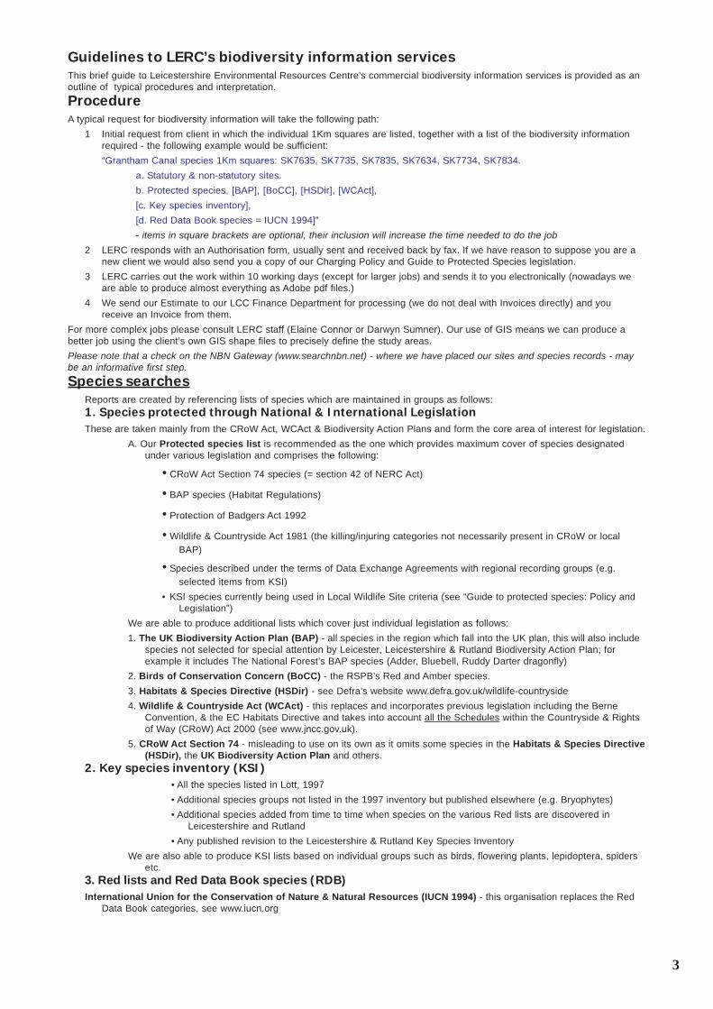
MapsMaps produced for a single area of study depict the following categories of sites of wildlife interest:
1 Non-statutory sites: Local Wildlife Sites (standard map)The current evaluation system is termed “Local Wildlife Sites”, elsewhere in the country termed “SINCs”or even “SNCIs”. Theevaluation criteria are published in Guidelines for the selection of Sites of Importance for Nature Conservation in Leicester, Leices-tershire and Rutland by a partnership including Leicestershire county Council, Leicester City Council, English Nature, CharnwoodWildlife & Leicestershire & Rutland Wildlife Trust in 2001 (copies available from this office). Revision 3 of these guidelines is to bepublished shortly. This system forms the only valid one for local authorities’ Local Plans.The following system is discontinued as a practise but remains on our reports and maps as it still contains valuable data:
2 Non-statutory sites: Phase 1 evaluation (standard map)An ecological site evaluation system was employed by the Ecology Unit of Leicestershire Museums, Arts and Records Service for anumber of years. Many hundreds of Phase 1 habitat surveys were carried out under this system which resulted in the developmentof a 3-tier categorisation (Parish, District and County - level sites) which was used to inform past plans. A good deal of surveyinformation, including species lists, is held at LERC as a result of these surveys and on the whole this material remains in paperform.The map is a useful guide to sites that have been surveyed and considered important under the original system. This system underwhich the Parish, District and County level sites were identified has now been discontinued. It has been superseded by a new LocalWildlife Site (LWS) system, which concentrates on evaluating Local Wildlife Sites only. Parish, District and County level sites maystill retain some or all of their ecological value and with appropriate management may have improved. They are all classed aspotential Local Wildlife Sites (pLWS) and are being resurveyed to establish their current status.
3 Statutory sites and others (standard map)A map of the Statutory sites (SSSIs etc.) and others (e.g. Leicestershire & Rutland Wildlife Trust reserves) are normally includedwith the above two standard maps unless they obscure other details. Separate maps may be produced on request. Data sheets andformal Citations may be requested from LERC on the statutory areas depicted.
4 Biodiversity Action Plan habitats (on request)The Leicester, Leicestershire & Rutland Biodiversity Action Plan prioritises 18 “at-risk” habitats in the region. Whilst the currentevaluation system for Local Wildlife Sites includes plans to assess all the habitats detailed in the BAP, this work will take some timeto complete:
5 Protected speciesAs an aid to the interpretation of the protected species lists and in response to requests by customers, these maps were introducedin September 2007 to improve our services. At the moment the production of an up-to-date layer is extremely time consuming sountil we are able to develop a rapid system, please note the date on each “Protected species” map is January 2009.The map shows the presence of the protected species listed below and was created using a GIS layer. Take care to examine thespecies lists as species records on these lists after the map’s date will not appear on the map.

5
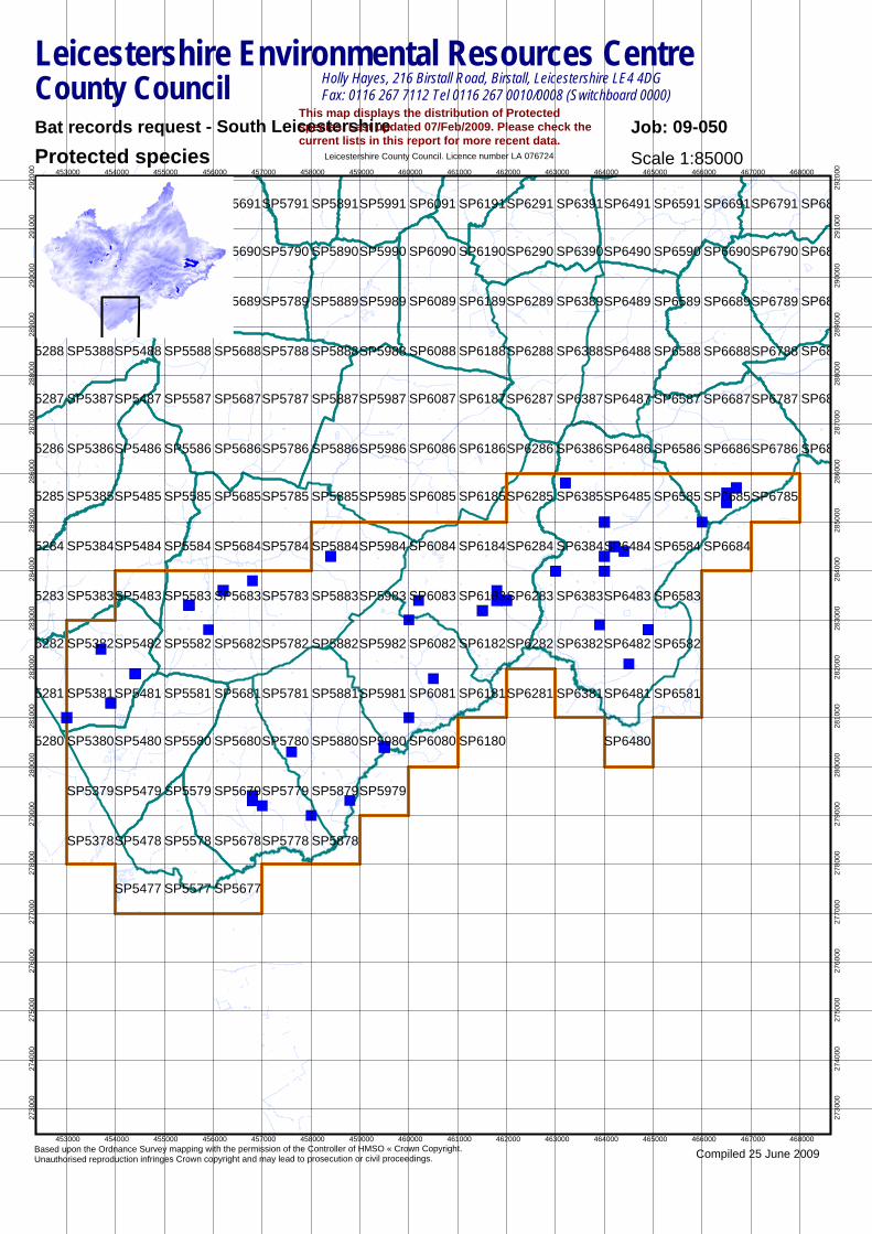
Site listsInterpretation of site lists
Site lists are typically presented as follows:1. The 1Km square into which each site occurs2. Location name. This may differ from the Site name if the Site comprises more than one Location (see Reference)3. Digitised object number. This uniquely identifies the digitised polygon and will be seen displayed on maps and on the NBN
Gateway (if it is a Local Wildlife Site component)4. Grid ref. The full grid reference - centroid of the location to 6 figures5. Status: The current system of non-statutory Local Wildlife Sites is in this list as “Wildlife Sites”, the discontinued system of
three tiers (County, District and Parish) serve to indicate that surveys have been carried out in the past and may be obtainedfrom LERC. Items prefixed Hnn are locations that have been flagged as belonging to the habitat which makes up theLeicester, Leicestershire and Rutland Biodiversity Action Plans; this does not automatically mean that they are Local WildlifeSites but it most certainly means that they are scheduled for survey when time allows.
6. Reference: Document references (quoting these will enable us to locate older surveys should you wish further information).The bracketted number is the reference to the Local Wildlife Site.
7. Area (hectares)
The list only includes non-statutory locations which have been digitised and are shown on the maps. There may be many morelocations within the area searched, particularly those which are popular with amateur recorders (who provide about 80% of ourspecies data) but do not necessarily record to precisely defined polygons or travel in time. The list of species provided elsewhere inthis document may therefore refer to sites not listed.
Map legendThe following fill patterns and border colours are used to differentiate the different categories of site on the maps:
Please note that Biodiversity Action Plan Habitats are not normally supplied, those available may be included upon request butplease be aware that they may obscure other detail.ReferencesLott. D. 1997. An Inventory of Key Species in Leicestershire and Rutland. Leicestershire County CouncilMcPhail, J. 2005. Protected Species Decisions for Development Control. Leicestershire County CouncilSmith, G., 1997. Habitats regulations guidance note 1, The Appropriate Assessment (Regulations 48). The Conservation (Natural
Habitats &c) Regulations, 1994. English NatureSmith, G., 1997. Habitats regulations guidance note 2, Review of existing planning permissions and other consents. The Conserva-
tion (Natural Habitats &c) Regulations, 1994. English NatureSmith, G., 1997. Habitats regulations guidance note 3, The Determination of Likely Significant Effect under The Conservation
(Natural Habitats &c) Regulations, 1994. English NatureDepartment of the Environment, 1995. The Habitats Directive: How it will apply in Great Britain. Department of the Environment,
The Scottish Office, Joint Nature Conservation CommitteeSumner, D., 2005. Guide to protected species: Species Policy Legislation. Leicestershire Environmental Resources Centre.
Leicestershire County Council.Sumner, D., 2007. Guide to protected species: Species Policy Legislation. Leicestershire Environmental Resources Centre.
Leicestershire County Council.Sumner, D., 2006. Charging Policy 2006. Leicestershire Environmental Resources Centre. Leicestershire County Council.
SP6090
SP6091
SP6190
SP6191
SP6290
SP6291
SP6390
SP6391
SP6490
SP6491
SP6590
SP6591
SP6690
SP6691
SP6790
SP6791
SP68
SP68
SP6080
SP6081
SP6082
SP6083
SP6084
SP6085
SP6086
SP6087
SP6088
SP6089
SP6180
SP6181
SP6182
SP6183
SP6184
SP6185
SP6186
SP6187
SP6188
SP6189
SP6281
SP6282
SP6283
SP6284
SP6285
SP6286
SP6287
SP6288
SP6289
SP6381
SP6382
SP6383
SP6384
SP6385
SP6386
SP6387
SP6388
SP6389
SP6480
SP6481
SP6482
SP6483
SP6484
SP6485
SP6486
SP6487
SP6488
SP6489
SP6581
SP6582
SP6583
SP6584
SP6585
SP6586
SP6587
SP6588
SP6589
SP6684
SP6685
SP6686
SP6687
SP6688
SP6689
SP6785
SP6786
SP6787
SP6788
SP6789
SP68
SP68
SP68
SP68
5290
5291
SP5390
SP5391
SP5490
SP5491
SP5590
SP5591
SP5690
SP5691
SP5790
SP5791
SP5890
SP5891
SP5990
SP5991
5280
5281
5282
5283
5284
5285
5286
5287
5288
5289
SP5380
SP5381
SP5382
SP5383
SP5384
SP5385
SP5386
SP5387
SP5388
SP5389
SP5480
SP5481
SP5482
SP5483
SP5484
SP5485
SP5486
SP5487
SP5488
SP5489
SP5580
SP5581
SP5582
SP5583
SP5584
SP5585
SP5586
SP5587
SP5588
SP5589
SP5680
SP5681
SP5682
SP5683
SP5684
SP5685
SP5686
SP5687
SP5688
SP5689
SP5780
SP5781
SP5782
SP5783
SP5784
SP5785
SP5786
SP5787
SP5788
SP5789
SP5880
SP5881
SP5882
SP5883
SP5884
SP5885
SP5886
SP5887
SP5888
SP5889
SP5980
SP5981
SP5982
SP5983
SP5984
SP5985
SP5986
SP5987
SP5988
SP5989
SP5378
SP5379
SP5477
SP5478
SP5479
SP5577
SP5578
SP5579
SP5677
SP5678
SP5679
SP5778
SP5779
SP5878
SP5879SP5979
Scale 1:85000
Compiled 25 June 2009
Bat records request - South Leicestershire
Based upon the Ordnance Survey mapping with the permission of the Controller of HMSO « Crown Copyright. Unauthorised reproduction infringes Crown copyright and may lead to prosecution or civil proceedings.
Leicestershire County Council. Licence number LA 076724Protected species
Leicestershire Environmental Resources CentreCounty Council Holly Hayes, 216 Birstall Road, Birstall, Leicestershire LE4 4DG
Fax: 0116 267 7112 Tel 0116 267 0010/0008 (Switchboard 0000)
Job: 09-050This map displays the distribution of Protectedspecies. Last updated 07/Feb/2009. Please check thecurrent lists in this report for more recent data.
453000 454000 455000 456000 457000 458000 459000 460000 461000 462000 463000 464000 465000 466000 467000 468000
453000 454000 455000 456000 457000 458000 459000 460000 461000 462000 463000 464000 465000 466000 467000 468000
2730
0027
4000
2750
0027
6000
2770
0027
8000
2790
0028
0000
2810
0028
2000
2830
0028
4000
2850
0028
6000
2870
0028
8000
2890
0029
0000
2910
0029
2000
2730
0027
4000
2750
0027
6000
2770
0027
8000
2790
0028
0000
2810
0028
2000
2830
0028
4000
2850
0028
6000
2870
0028
8000
2890
0029
0000
2910
0029
2000

Leicestershire Environmental Resources CentreHolly Hayes 216 Birstall Road Birstall LE4 4DG CONFIDENTIAL
Bat recordsDate Location RecorderSpeciesGrid reference29/10/1959 Vespertilionidae Vespertilionidae Ian M. Evans30/09/1962 Myotis daubentonii Daubenton's Bat Ian M. Evans30/09/1962 Myotis daubentonii Daubenton's BatH. Bosworth Tunnel (Bat roost) Ian M. Evans01/01/1981 - 31/12/1981 Plecotus auritus Brown Long-Eared BatKeepers Cottage (Bat roost) Northants Bat Group01/01/1981 - 31/12/1981 Plecotus auritus Brown Long-eared Bat Northants Bat Group11/07/1982 Plecotus auritus Brown Long-eared Bat Northants Bat Group11/07/1982 Plecotus auritus Brown Long-Eared BatKeepers Cottage (Bat roost) Northants Bat Group07/06/1983 Chiroptera BatsHome Farm (Bat roost) Nature Conservancy Council02/07/1984 Pipistrellus Common PipistrelleCranmar, Elmcroft Rd (Bat roost) Derek Lott02/07/1984 Pipistrellus Common Pipistrelle Derek Lott05/08/1987 Plecotus auritus Brown Long-eared Bat Jan Dawson12/04/1988 Plecotus auritus Brown Long-eared Bat Val Hennessy12/04/1988 Plecotus auritus Brown Long-Eared BatHome Farm (Bat roost) Val Hennessy27/05/1988 Vespertilionidae Vespertilionidae Unknown04/07/1988 Plecotus auritus Brown Long-eared BatCotesbach, Mkt. Harborough (Bat roost) Steve Grover22/08/1988 Vespertilionidae Vespertilionidae Sheila Walsh22/08/1988 Chiroptera BatsWarren Farm (Bat roost) Sheila Walsh08/09/1988 Chiroptera BatsWarren Farm (Bat roost) Lucy Eakes08/09/1988 Vespertilionidae Vespertilionidae Lucy Eakes10/09/1988 Vespertilionidae Vespertilionidae Val Hennessy20/09/1988 Chiroptera BatsStrawfield House (Bat roost) Jan Dawson20/09/1988 Vespertilionidae Vespertilionidae Jan Dawson13/10/1988 Vespertilionidae Vespertilionidae Lucy Eakes13/10/1988 Chiroptera BatsTall Trees, Theddingworth (Bat roost) Lucy Eakes01/01/1989 - 31/12/1989 Vespertilionidae Vespertilionidae Sheila Walsh24/07/1989 Vespertilionidae Vespertilionidae Val Hennessy
1Confidential: This report contains sensitive information about the location of protected species and has been provided in confidence to assist you in your work. Because
of this, OS Grid References must be withheld from documents destined for public consumption. Environmental Information Regulations Exception (12)(g).
Leicestershire Environmental Resources CentreHolly Hayes 216 Birstall Road Birstall LE4 4DG CONFIDENTIAL
Date Location RecorderSpeciesGrid reference22/08/1989 Plecotus auritus Brown Long-eared Bat Jan Dawson01/07/1990 Pipistrellus Common Pipistrelle Mary Fullylove23/03/1991 Plecotus auritus Brown Long-eared Bat Mary Fullylove23/03/1991 Plecotus auritus Brown Long-Eared BatHighcroft Ldge Farm (Bat roost) Mary Fullylove08/06/1993 Chiroptera BatsRailway farm (Bat roost) Jan Dawson08/06/1993 Vespertilionidae Vespertilionidae Jan Dawson01/07/1993 Vespertilionidae Vespertilionidae Val Hennessy01/07/1993 Chiroptera BatsMascot Main Street (Bat roost) Val Hennessy27/08/1993 Pipistrellus Common Pipistrelle Jan Dawson13/01/1997 Plecotus auritus Brown Long-Eared BatTanser Cottage, Walcote Road, South Kilworth Jan Dawson08/06/2000 Pipistrellus PipistrellusKilworth House (Bat roost) Andrew Harvey;Trudy Rossa06/11/2000 Chiroptera ChiropteraThe Bank, Bosworth Road Gaynor Allen27/11/2000 Chiroptera ChiropteraThe Bank, Bosworth Road Gaynor Allen23/08/2003 Vespertilionidae BatsTheddingworth Church (Bat roost) Unknown01/07/2004 Vespertilionidae BatsAvon Valley Farm (Bat roost) FPCRJuly 2004 Pipistrellus Common PipistrelleWakeley Farm (Bat roost)July 2004 Plecotus auritus Brown Long-eared BatWakeley Farm (Bat roost)14/07/2004 Plecotus auritus Brown Long-eared BatPack's Hill Farm (Bat roost) Howard Hillier16/07/2004 Chiroptera BatsMain Street, Branscombe (Bat roost) Terry Durnin;Vicki 10/09/2004 Plecotus auritus Brown Long-eared BatThe Old Corner House, Swimming Pool Jenny Harris15/09/2004 Plecotus auritus Brown Long-eared BatHigh Street, North Kilworth (Bat roost) Nathalie Cossa15/09/2004 Pipistrellus Common PipistrelleHigh Street, North Kilworth (Bat roost) Nathalie Cossa26/01/2005 Plecotus auritus Brown Long-eared BatStanford Hall Stables Richard Fox26/01/2005 Plecotus auritus Brown Long-eared BatStanford Hall Outbuildings Richard Fox03/05/2005 Pipistrellus Common PipistrelleHome Farm, Barn 2, Swinford (Bat roost)03/05/2005 Pipistrellus pygmaeus Soprano PipistrelleHome Farm, Barn 2, Swinford (Bat roost)03/05/2005 Plecotus auritus Brown Long-eared BatHome Farm, Barn 2, Swinford (Bat roost)03/05/2005 Chiroptera BatsHome Farm, Barn 2, Swinford (Bat roost)
2Confidential: This report contains sensitive information about the location of protected species and has been provided in confidence to assist you in your work. Because
of this, OS Grid References must be withheld from documents destined for public consumption. Environmental Information Regulations Exception (12)(g).
Leicestershire Environmental Resources CentreHolly Hayes 216 Birstall Road Birstall LE4 4DG CONFIDENTIAL
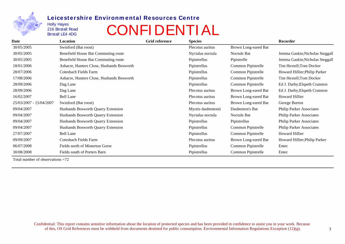
Date Location RecorderSpeciesGrid reference30/05/2005 Plecotus auritus Brown Long-eared BatSwinford (Bat roost)30/05/2005 Nyctalus noctula Noctule BatBenefield House Bat Commuting route Jemma Gaskin;Nicholas Steggall30/05/2005 Pipistrellus PipistrelleBenefield House Bat Commuting route Jemma Gaskin;Nicholas Steggall18/01/2006 Pipistrellus Common PipistrelleAshacre, Hunters Close, Husbands Bosworth Tim Hextell;Tom Docker28/07/2006 Pipistrellus Common PipistrelleCotesbach Fields Farm Howard Hillier;Philip Parker 17/08/2006 Pipistrellus Common PipistrelleAshacre, Hunters Close, Husbands Bosworth Tim Hextell;Tom Docker28/09/2006 Pipistrellus Common PipistrelleDag Lane Ed J. Darby;Elspeth Cranston28/09/2006 Plecotus auritus Brown Long-eared BatDag Lane Ed J. Darby;Elspeth Cranston16/02/2007 Plecotus auritus Brown Long-eared BatBell Lane Howard Hillier25/03/2007 - 15/04/2007 Plecotus auritus Brown Long-eared BatSwinford (Bat roost) George Burton09/04/2007 Myotis daubentonii Daubenton's BatHusbands Bosworth Quarry Extension Philip Parker Associates09/04/2007 Nyctalus noctula Noctule BatHusbands Bosworth Quarry Extension Philip Parker Associates09/04/2007 Pipistrellus PipistrellusHusbands Bosworth Quarry Extension Philip Parker Associates09/04/2007 Pipistrellus Common PipistrelleHusbands Bosworth Quarry Extension Philip Parker Associates27/07/2007 Pipistrellus Common PipistrelleBell Lane Howard Hillier09/09/2007 Plecotus auritus Brown Long-eared BatCotesbach Fields Farm Howard Hillier;Philip Parker 06/07/2008 Pipistrellus Common PipistrelleFields north of Misterton Gorse Entec30/08/2008 Pipistrellus Common PipistrelleFields south of Porters Barn Entec
Total number of observations =72
3Confidential: This report contains sensitive information about the location of protected species and has been provided in confidence to assist you in your work. Because
of this, OS Grid References must be withheld from documents destined for public consumption. Environmental Information Regulations Exception (12)(g).

Northants Bat Group
10 Bedford Cottages Great Brington
Northampton NN7 4JF
01604 770632 [email protected]
Entec UK Ltd Princes Exchange Princes Square Leeds LS1 4BY 26th June 2009
Winwick Warren 10km data search Bat Database Search There are currently 12 of the 17 UK bat species recorded in the county of Northamptonshire. The attached spread-sheet should in no way be taken as fully representative of the bat roosts in the area. The bat group has unsystematically collected the results since 1980 during surveys. Bats have a lifespan up to 30 years in the UK (present research) and so records from over the last two decades are a very good indicator of the presence in an area of these long-lived mammal species. Older records should not be ignored. These results are not to be used in place of thorough site-specific and species-specific bat surveys, which should be undertaken for all developments. These data are for your use on this contract and should not be passed on to third parties. The disused rail tunnels at Kelmarsh (and further north at Gt Oxenden) are used by a number of species for winter hibernation and possible swarming. The Grand Union canal passes close by the site and is used by a number of species for foraging as well as a commuter route. We have tracked Daubenton’s bats many kilometres each evening along this waterway. There have only been three records of serotine in Northamptonshire in 30 years, and these have all been foraging bats or bats passing over. Otter spraints have recently been found by the Grand Union canal NE of Yelvertoft. It appears that water voles are using the steam that runs along the eastern side of Yelvertoft. Phil Richardson
1
Any bat records generated by your fieldwork, in any format, would be gratefully received to update and further our knowledge of bats for conservation purposes.

2
Ref Site Grid ref Date Status
Pipistrelle 113 Ashby St Ledgers Church SP5768 from 1981 Roost 407 Clipston Church SP7181 1981 Roost
2153 Clipston, Barn in field, Naseby/Sibbertoft Rd SP7081 2007 Roost
406 Clipston, Kelmarsh Road SP7181 1997 Roost 1428 Cottesbrooke centre SP7073 1984 One grounded 164 Cottesbrooke, Station Road SP7173 1996 Roost 165 Cottsebrooke cottage SP7073 1991 Roost 432 Creaton, The Jetty SP7071 1985 Roost 1237 Crick centre SP5872 1988 One grounded 1270 Crick centre SP5872 1987 One grounded 436 Crick Church SP5872 from 1981 Roost 783 Crick, The High Leys SP5871 from 1986 Roost 1487 Crick, Ashby Drive SP5872 1983 One grounded 433 Crick, Oak Lane SP5872 1993 Roost 435 Crick, Rectory Close SP5872 1982 Roost 434 Crick, Rectory Close (2) SP5872 1982 Roost 453 East Haddon, Tilbury Rise SP6668 1989 Roost 1770 East Haddon, Northfield Green SP6668 2000 One grounded 454 East Haddon, Orchard Close SP6668 from 1983 Roost 455 East Haddon, Orchard Close (2) SP6668 from 1982 Roost 1271 East Haddon, Priestwell Court SP6668 1987 One grounded 2274 East Haddon, Ravensthorpe Road SP6668 2008 Roost 1248 East Haddon, cottage SP6668 1988 One grounded 1689 East Haddon, Tilbury Road SP6668 2000 Roost 52 East Haddon,Church Lane SP6667 1997 One grounded
1364 Elkington canal SP6276 1985 Foraging 182 Elkington, farm SP6376 1991 Roost 1149 Elkington, farm SP6276 1991 One grounded 799 Elkington, house SP6276 from 1982 Roost 1033 Great Brington church SP6665 from 1994 Roost 497 Guilsborough Church SP6772 from 1981 Roost 1333 Guilsborough School SP6773 1986 One grounded 499 Guilsborough, Church Mount SP6772 from 1982 Roost 498 Guilsborough, West Haddon Road SP6773 1992 Roost 2145 Guilsborough, The Green SP6773 2007 Roost 2001 Guilsborough, Naseby Road SP6773 2005 One grounded 1680 Guilsborough, The Green (2) SP6773 2000 Roost 1667 Guilsborough, The Green (3) SP6773 1999 Roost 512 Haselbech Church SP7177 from 1981 Roost 1059 Hollowell, Spring Close SP6971 1993 One grounded 524 Hollowell, Guilsborough Hill SP6872 1993 Roost 1050 Hollowell, Guilsborough Hill SP6872 1993 One grounded 1361 Hollowell, Church Hill SP6971 1985 One grounded 523 Hollowell, Creaton Rd SP6971 1993 Roost 1328 Hollowell, Orchard Close SP6871 1986 One grounded

3
533 Kelmarsh, cottage SP7379 1997 Roost 2186 Kilsby centre, SP5671 2004 Roost 237 Lilbourne Church SP5677 from 1993 Roost 1028 Lilbourne churchyard SP5677 1994 Foraging 49 Long Buckby SP6267 1997 One grounded
1582 Long Buckby canal, north branch to Watford SP6065 1982 Foraging
1213 Long Buckby gated road SP6466 1989 One grounded 1584 Long Buckby Wharf bridge SP6165 1982 Roost 554 Long Buckby Wharf, cottage SP6165 1995 Roost 556 Long Buckby, Marriotts Road SP6367 1993 Roost 557 Long Buckby, Marriotts Road (2) SP6367 1990 Roost 555 Long Buckby, Marriotts Road (3) SP6367 1989 Roost 844 Long Buckby, Hall Drive SP6367 from 1983 Roost 845 Long Buckby, South Close SP6267 from 1982 Roost 1988 Long Buckby, Parkfield Road SP6267 2004 Roost 1272 Long Buckby, Brington Road estate SP6367 1987 One grounded 1401 Naseby centre SP6877 1984 One grounded 81 Naseby Church SP6878 from 1981 Roost
2010 Naseby, Church Street SP6877 2005 Roost 2251 Ravensthorpe Church SP6770 2008 Roost 1367 Ravensthorpe Reservoir grounds SP6770 from 1985 Foraging 642 Ravensthorpe, Little Lane SP6670 1997 Roost 644 Ravensthorpe, Paddock Close SP6670 from 1987 Roost 879 Ravensthorpe, Guilsborough Road SP6670 1983 Roost 643 Ravensthorpe, Guilsborough Rd (2) SP6670 1989 Roost 1215 Ravensthorpe, near pub SP6670 1989 One grounded 880 Ravensthorpe, opp Chequers pub SP6770 1983 Roost 878 Ravensthorpe, Guilsborough Rd (3) SP6670 1984 Roost 877 Ravensthorpe, Guilsborough Rd (4) SP6670 from 1984 Roost 895 Spratton, house SP7170 from 1985 Roost 1109 Spratton, Gorse Road SP7170 1992 One grounded 1800 Spratton, Church Road SP7170 2001 Roost 970 Spratton, house SP7170 1996 One grounded 671 Stanford Church SP5878 from 1981 Roost 1221 Stanford/Cold Ashby canal SP6178 1989 Foraging 315 Sulby, house SP6681 from 1982 Roost 1211 Sulby Reservoir/Lily Pond SP6581 1989 Roost 901 Sulby,house SP6581 1989 Roost 314 Sulby, cottage SP6582 1997 Roost 1360 Teeton centre SP6970 1985 One grounded 84 Thornby, house SP6775 1994 Roost
1506 Watford canal, west road bridge SP5969 1983 Foraging 701 Watford Church SP6069 1994 Roost 1730 Welford, Salford Close SP6480 2001 Roost 704 Welford, house SP6379 1994 Roost 1877 Welford, Newlands Road SP6480 2003 Roost 1334 West Haddon centre SP6371 1986 One grounded 85 West Haddon Church SP6371 1992 Roost
4
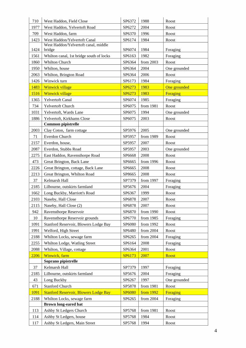
710 West Haddon, Field Close SP6372 1988 Roost 1977 West Haddon, Yelvertoft Road SP6272 2004 Roost 709 West Haddon, farm SP6370 1996 Roost 1423 West Haddon/Yelvertoft Canal SP6174 1984 Roost
1424 West Haddon/Yelvertoft canal, middle bridge SP6074 1984 Foraging
1561 Whilton canal, 1st bridge south of locks SP6163 1982 Foraging 1860 Whilton Church SP6364 from 2003 Roost 1950 Whilton, house SP6364 2004 One grounded 2063 Whilton, Brington Road SP6364 2006 Roost 1426 Winwick turn SP6173 1984 Foraging 1483 Winwick village SP6273 1983 One grounded 1516 Winwick village SP6273 1983 Foraging 1365 Yelvertoft Canal SP6074 1985 Foraging 734 Yelvertoft Church SP6075 from 1981 Roost 1031 Yelvertoft, Wards Lane SP6075 1994 One grounded 1886 Yelvertoft, Kirkhams Close SP6075 2003 Roost Common pipistrelle 2003 Clay Coton, farm cottage SP5976 2005 One grounded 71 Everdon Church SP5957 from 1989 Roost
2157 Everdon, house, SP5957 2007 Roost 2087 Everdon, Stubbs Road SP5957 2003 One grounded 2275 East Haddon, Ravensthorpe Road SP6668 2008 Roost 473 Great Brington, Back Lane SP6665 from 1996 Roost 2226 Great Brington, cottage, Back Lane SP6665 2008 Roost 2213 Great Brington, Whilton Road SP8665 2008 Roost 37 Kelmarsh Hall SP7379 from 1997 Foraging
2185 Lilbourne, outskirts farmland SP5676 2004 Foraging 1662 Long Buckby, Marriott's Road SP6367 1999 Roost 2103 Naseby, Hall Close SP6878 2007 Roost 2115 Naseby, Hall Close (2) SP6878 2007 Roost 942 Ravensthorpe Reservoir SP6870 from 1990 Roost 10 Ravensthorpe Reservoir grounds SP6770 from 1985 Foraging
1091 Stanford Reservoir, Blowers Lodge Bay SP6080 from 1992 Roost 1991 Welford, High Street SP6480 from 2004 Roost 2188 Whilton Locks, sewage farm SP6265 from 2004 Foraging 2255 Whilton Lodge, Watling Street SP6164 2008 Foraging 2088 Whilton, Village, cottage SP6364 2001 Roost 2206 Winwick, farm SP6173 2007 Roost Soprano pipistrelle 37 Kelmarsh Hall SP7379 1997 Foraging
2185 Lilbourne, outskirts farmland SP5676 2004 Foraging 43 Long Buckby SP6267 1997 One grounded 671 Stanford Church SP5878 from 1981 Roost 1091 Stanford Reservoir, Blowers Lodge Bay SP6080 from 1992 Foraging 2188 Whilton Locks, sewage farm SP6265 from 2004 Foraging Brown long-eared bat 113 Ashby St Ledgers Church SP5768 from 1981 Roost 114 Ashby St Ledgers, house SP5768 1984 Roost 117 Ashby St Ledgers, Main Street SP5768 1994 Roost
5
118 Ashby St Ledgers, Main St (2) SP5668 1993 Roost 115 Ashby St Ledgers, farm, Main St SP5768 1998 Roost 2287 Clipston, Pegs Lane SP7081 2008 Roost
2153 Clipston, Barn in field, Naseby/Sibbertoft Rd SP7081 2007 Roost
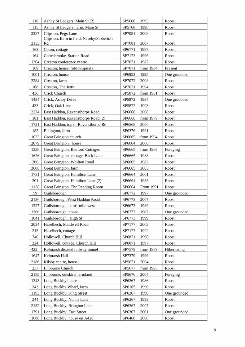
163 Coton, cottage SP6771 1997 Roost 164 Cottesbrooke, Station Road SP7173 1996 Roost 1304 Creaton conference centre SP7071 1987 Roost 169 Creaton, house, (old hospital) SP7071 from 1984 Present 1001 Creaton, house SP6953 1995 One grounded 2284 Creaton, farm SP7072 2008 Roost 168 Creaton, The Jetty SP7071 1994 Roost 436 Crick Church SP5872 from 1981 Roost 1434 Crick, Ashby Drive SP5872 1984 One grounded 433 Crick, Oak Lane SP5872 1993 Roost 2274 East Haddon, Ravensthorpe Road SP6668 2008 Roost 181 East Haddon, Ravensthorpe Road (2) SP6668 from 1979 Roost 1721 East Haddon, top of Ravensthorpe Rd SP6568 2000 Roost 182 Elkington, farm SP6376 1991 Roost 1033 Great Brington church SP6665 from 1994 Roost 2079 Great Brington, house SP6664 2006 Roost 1338 Great Brington, Bedford Cottages SP6665 from 1986 Foraging 1626 Great Brington, cottage, Back Lane SP6665 1988 Roost 200 Great Brington, Whilton Road SP6665 1983 Roost 2008 Great Brington, farm SP6665 2005 Roost 1751 Great Brington, Hamilton Lane SP6664 2001 Roost 201 Great Brington, Hamilton Lane (2) SP6664 1986 Roost 1158 Great Brington, The Reading Room SP6664 From 1991 Roost 59 Guilsborough SP6772 1997 One grounded
2136 Guilsborough,West Haddon Road SP6773 2007 Roost 1227 Guilsborough, barn1 mile west SP6673 1989 Roost 1306 Guilsborough, house SP6772 1987 One grounded 1641 Guilsborough, High St SP6773 1999 Roost 2034 Haselbech, Maidwell Road SP7177 2005 Roost 215 Haselbech, cottage SP7177 1992 Roost 740 Hollowell, Church Hill SP6871 1998 Roost 224 Hollowell, cottage, Church Hill SP6871 1997 Roost 422 Kelmarsh disused railway tunnel SP7579 from 1989 Hibernating 1647 Kelmarsh Hall SP7379 1999 Roost 2186 Kilsby centre, house SP5671 2004 Roost 237 Lilbourne Church SP5677 from 1993 Roost 2185 Lilbourne, outskirts farmland SP5676 2004 Foraging 1343 Long Buckby house SP6267 1986 Roost 243 Long Buckby Wharf, farm SP6165 1996 Roost 1193 Long Buckby, King Street SP6267 1990 One grounded 244 Long Buckby, Nunns Lane SP6267 1993 Roost 2152 Long Buckby, Brington Lane SP6367 2007 Roost 1791 Long Buckby, East Street SP6367 2001 One grounded 1686 Long Buckby, house on A428 SP6468 2000 Roost

6
2098 Long Buckby, nr Vanderplanks Covert SP6268 2007 Roost 245 Long Buckby, farm, West Haddon Road SP6569 1988 Roost 1155 Naseby house SP6679 1991 One grounded 2115 Naseby, Hall Close SP6878 2007 Roost 36 Ravensthorpe Reservoir, east building SP6770 from 1982 Roost 306 Spratton Church SP7170 1998 Roost 307 Spratton, Church Road SP7170 1990 Roost 1792 Spratton, house SP7069 2001 One grounded 1781 Spratton, Old Reading Room SP7170 2000 Roost 671 Stanford Church SP5878 from 1981 Roost 1012 Stanford Reservoir tunnel roost SP5980 1994 Roost 1369 Stanford Reservoir SP5980 from1985 Roost 1091 Stanford Reservoir, Blowers Lodge Bay SP6080 from 1992 Foraging 315 Sulby house SP6681 from 1982 Roost 314 Sulby, cottage SP6582 1997 Roost 2252 Teeton, house SP6970 2008 Roost 84 Thornby house SP6775 1994 Roost 328 Thornby, Estate Yard barn SP6775 1988 Roost 1850 Thornby, N end SP6775 2002 One grounded 327 Thornby, cottage SP6775 1998 Roost 1003 Watford SP6069 1995 One grounded 348 Welford house, Naseby Road SP6480 1994 Roost 1194 Welford, home, A50 SP6480 1990 One grounded 1994 Welford, Church SP6480 2004 Roost 1991 Welford, farm, High Street SP6480 from 2004 Roost 85 West Haddon Church SP6371 1992 Roost
1530 West Haddon farm SP6272 1983 Roost 1890 West Haddon, farm (2) SP6472 2003 Roost 1196 West Haddon, old chapel SP6371 1990 One grounded 2184 West Haddon, bungalow SP6371 2007 Roost 1081 West Haddon/Yelvertoft Canal SP6174 from 1993 Foraging 86 Winwick Church SP6273 from 1980 Roost 356 Winwick, Yelvertoft Road SP6173 1997 Roost 2206 Winwick, farm SP6173 2007 Roost 357 Winwick house SP6273 from 1980 Roost Daubenton's bat 940 Cottesbrooke Lakes SP7173 1996 Foraging 743 Crick Canal Tunnel SP5971 1998 Roost 1351 Elkington canal SP6276 from 1985 Foraging 422 Kelmarsh disused railway tunnel SP7579 from 1989 Hibernating 6 Kelmarsh Hall Lake SP7379 from 1997 Foraging
1544 Long Buckby canal, north branch to Watford SP6065 from 1982 Foraging
942 Ravensthorpe Reservoir SP6870 from 1990 Foraging 90 Sulby Reservoir SP6581 1988 Roost
1205 Sulby Reservoir/Lily Pond SP6581 1989 Foraging 1458 Watford canal, 1st bridge N of road SP5969 from 1983 Foraging 1459 Watford canal, nr M1 bridge SP5969 from 1983 Foraging 1460 Watford canal, west road bridge SP5969 1983 Foraging 1206 West Haddon/Yelvertoft Canal SP6174 from 1989 Foraging

7
1391 West Haddon/Yelvertoft canal, middle bridge SP6074 1984 Foraging
1543 Whilton canal, 1st bridge south of locks SP6163 from 1982 Foraging 2188 Whilton Locks, sewage farm SP6265 from 2004 Foraging
1 Yelvertoft Canal SP6074 1997 Foraging 1207 Yelvertoft/West Haddon Canal SP6075 from 1989 Foraging Natterer's bat 1122 Cold Ashby Church SP6576 from 1991 Roost 2163 Cottesbrooke, Hall, stables SP7173 2007 Roost 1089 Great Brington, Fox and Hounds SP6664 1992 One grounded 1999 Great Brington, farm SP6665 2005 One grounded 1202 Hollowell, by green SP6972 1989 One grounded 422 Kelmarsh disused railway tunnel SP7579 from 1989 Hibernating 81 Naseby Church SP6878 from 1981 Roost
1012 Stanford Reservoir tunnel roost SP5980 from 1988 Roost 1014 Stanford Reservoir, Blowers Lodge Bay SP6080 from 1992 Foraging 84 Thornby, house SP6775 1994 Roost 85 West Haddon Church SP6371 1992 Roost 86 Winwick Church SP6273 from 1980 Roost
Whiskered/Brandt's bat 165 Cottsebrooke, cottage SP7073 1991 Roost 2244 East Haddon, house SP6666 2000 Foraging 94 Guilsborough, High St SP6773 1991 Roost 96 Hollowell, Church Hill SP6971 1991 Roost 37 Kelmarsh Hall SP7379 from 1997 Roost 100 Ravensthorpe Reservoir, east building SP6770 from 1982 Roost 99 Ravensthorpe, Main St SP6670 1983 Roost 937 Stanford Reservoir, nr dam SP5980 from 1990 Foraging Whiskered bat 938 Stanford Reservoir, Blowers Lodge Bay SP6080 from 1990 Foraging 103 Watford, cottage SP6068 1994 Roost Brandt's bat 1091 Stanford Reservoir, Blowers Lodge Bay SP6080 from 1990 Foraging 1758 Welford, Salford Close SP6480 2001 One grounded Noctule 1166 East Haddon village SP6668 from 1990 Foraging 2275 East Haddon, Ravensthorpe Road SP6668 2008 Foraging 735 Great Brington village SP6665 1997 Foraging 37 Kelmarsh Hall SP7379 from 1997 Foraging
2185 Lilbourne, outskirts farmland SP5676 2004 Foraging
1553 Long Buckby canal, north branch to Watford SP6065 1982 Foraging
10 Ravensthorpe Reservoir grounds SP6770 from 1985 Foraging 1091 Stanford Reservoir, Blowers Lodge Bay SP6080 from 1992 Foraging 951 Stanford Reservoir, nr dam SP5980 from 1986 Foraging 1206 West Haddon/Yelvertoft Canal SP6174 1989 Foraging 1552 Whilton canal, 1st bridge south of locks SP6163 1982 Foraging 2188 Whilton Locks, sewage farm SP6265 from 2004 Foraging 1609 Winwick Church SP6273 from 1980 Foraging Serotine 1930 Stanford Reservoir, SP5980 2004 Foraging

8
PW Richardson

Environment Agency, Sentinel House, 9 Wellington Crescent, Fradley Park, Lichfield Staffordshire, WS13 8RR Customer Service Line: 08708 506 506 Email: [email protected] www.environment-agency.gov.uk G:Plan & CS/ER/File Plan December 2006/Influence & Inform/Request for Information/FOI and EIR Searches/ Responses/MC17528
Our Ref: MC17528/DE
Your Ref: Date: 16 July 2009
Ms J Caddick Entec UK Ltd Princes Exchange Princes Square Leeds LS1 4BY
Dear Ms Caddick RE: COLD ASHBY Thank you for your enquiry requesting information relating to the above site. WATER BODIES The following watercourses are within the 2km study area: Designated ‘Main River’:
- There are no Main Rivers within 2km of the site. - The Clay Coton Brook flows through the study area and is Main
River from immediately upstream of Yelvertoft. Ordinary watercourses: There are numerous ordinary watercourses throughout the study area. These watercourses may be of ecological importance and may contain protected species Other Waterbodies: Grand Union Canal There are a number of ponds lakes and pools in the study area. Given the possibility that great crested newts are in the area all waterbodies should be identified and their ecological value assessed, particularly for amphibians, but also for other notable species.
Environment Agency, Sentinel House, 9 Wellington Crescent, Fradley Park, Lichfield Staffordshire, WS13 8RR Customer Service Line: 08708 506 506 Email: [email protected] www.environment-agency.gov.uk G:Plan & CS/ER/File Plan December 2006/Influence & Inform/Request for Information/FOI and EIR Searches/ Responses/MC17528
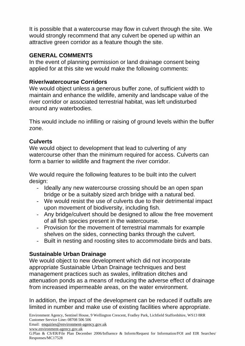
It is possible that a watercourse may flow in culvert through the site. We would strongly recommend that any culvert be opened up within an attractive green corridor as a feature though the site. GENERAL COMMENTS In the event of planning permission or land drainage consent being applied for at this site we would make the following comments: River/watercourse Corridors We would object unless a generous buffer zone, of sufficient width to maintain and enhance the wildlife, amenity and landscape value of the river corridor or associated terrestrial habitat, was left undisturbed around any waterbodies. This would include no infilling or raising of ground levels within the buffer zone. Culverts We would object to development that lead to culverting of any watercourse other than the minimum required for access. Culverts can form a barrier to wildlife and fragment the river corridor. We would require the following features to be built into the culvert design:
- Ideally any new watercourse crossing should be an open span bridge or be a suitably sized arch bridge with a natural bed.
- We would resist the use of culverts due to their detrimental impact upon movement of biodiversity, including fish.
- Any bridge/culvert should be designed to allow the free movement of all fish species present in the watercourse.
- Provision for the movement of terrestrial mammals for example shelves on the sides, connecting banks through the culvert.
- Built in nesting and roosting sites to accommodate birds and bats. Sustainable Urban Drainage We would object to new development which did not incorporate appropriate Sustainable Urban Drainage techniques and best management practices such as swales, infiltration ditches and attenuation ponds as a means of reducing the adverse effect of drainage from increased impermeable areas, on the water environment. In addition, the impact of the development can be reduced if outfalls are limited in number and make use of existing facilities where appropriate.
Environment Agency, Sentinel House, 9 Wellington Crescent, Fradley Park, Lichfield Staffordshire, WS13 8RR Customer Service Line: 08708 506 506 Email: [email protected] www.environment-agency.gov.uk G:Plan & CS/ER/File Plan December 2006/Influence & Inform/Request for Information/FOI and EIR Searches/ Responses/MC17528
Further to this, the use of locally appropriate materials in the design of outfalls will limit deterioration of visual amenity. DESIGNATED SITES We do not have records of designated sites in this area. However our records are not definitive and the following organisations should be contacted for further details of any sites and advice on any restrictions they may place on future development. SCHEDULED ANCIENT MONUMENTS AND HISTORIC GARDENS. English Heritage, East Midlands, Hazelrigg House, 33 Marefair, Northampton NN1 1SR (01604 730320)
SITES OF SPECIAL SCIENTIFIC INTEREST (SSSIS): Natural England, First Floor, The Maltings, Wharf Road, Grantham, Lincolnshire, NG31 6BH Tel: 01476 584800 Fax: 01476 584838 Email: [email protected]
SECOND TIER NATURE CONSERVATION SITES Northants Wildlife Trust, Lings house, Billings Lings, Northamptonshire, NN3 8BE. (01604 405285) Wildlife Sites CONSERVATION AREAS, TREE PRESERVATION ORDERS AND LISTED BUILDINGS: Contact the following: Northamptonshire County Council, PO Box 163, County Hall, Northamptonshire, NN1 1AX (O1604 236236) PROTECTED SPECIES We do not hold any records of protected species within the 2km study area. However Our records are not definitive and it is entirely possible that protected species are present in the area. There are a number of watercourses within the study area. All watercourses in the area are potentially used by otter since they started to re-colonise the Avon catchment in the early 1990s. It is very likely that otters are, or soon will be, using the brook and canal network as a dispersal route. Otters are known to use the Clay Coton Brook at least as far upstream as Clay Coton.

Environment Agency, Sentinel House, 9 Wellington Crescent, Fradley Park, Lichfield Staffordshire, WS13 8RR Customer Service Line: 08708 506 506 Email: [email protected] www.environment-agency.gov.uk G:Plan & CS/ER/File Plan December 2006/Influence & Inform/Request for Information/FOI and EIR Searches/ Responses/MC17528
Whether or not otter are currently found in the stretch directly affected by the proposal should not materially affect the detailed design or mitigation measures. All watercourses in the area need to be treated as if they are potentially used by otters. Mitigation for potential disturbance to otters should also include bankside cover and habitat improvements aimed at increasing fish density and numbers. We have no records of water vole within the study area. However it is possible that they are present, but have not be surveyed for. It is an offence to damage destroy or obstruct access to water vole habitat or disturb them which they are using any structure or place for shelter or protection. Further survey would be required to determine whether water voles are currently using any waterbodies within the site. Measures to avoid, reduce or remedy the impacts of any adverse effects of development would have to be agreed. We have no records of native white clawed crayfish within the study area. However it is possible that they are present, but have not be surveyed for. Further survey would be required to determine whether native crayfish are currently using any waterbodies within the site. Measures to avoid, reduce or remedy the impacts of any adverse effects of development would have to be agreed.
We have no records of Great Crested Newts within the study area. However it is possible that they are present, but have not be surveyed for. Individual newts and their habitats are protected. Because they regularly range 250m from breeding ponds and may well travel further if there are areas of high quality foraging and refuge or hibernating habitat the suitability of aquatic and terrestrial habitat within, and 500m from, the site for great crested newts will need to be assessed. If necessary measures to avoid, reduce or mitigate any adverse impacts of development would have to be agreed and could potentially require a Defra development licence, with respect to great crested newts. This could have implications in terms of the timing, extent and the nature of permitted development.

Environment Agency, Sentinel House, 9 Wellington Crescent, Fradley Park, Lichfield Staffordshire, WS13 8RR Customer Service Line: 08708 506 506 Email: [email protected] www.environment-agency.gov.uk G:Plan & CS/ER/File Plan December 2006/Influence & Inform/Request for Information/FOI and EIR Searches/ Responses/MC17528
The information provided above is based on records and files from various sources and of varying reliability. We cannot accept any liability for any loss or damage arising from the interpretation or use of the information. A site inspection has not been carried out in relation to your request for information. This information is provided under the conditions for use of data or information attached. Yours sincerely DIANE EDWARDS External Relations Assistant Direct dial 01543 404971 Direct email. [email protected]

Environment Agency, Sentinel House, 9 Wellington Crescent, Fradley Park, Lichfield Staffordshire, WS13 8RR Customer Service Line: 08708 506 506 Email: [email protected] www.environment-agency.gov.uk G:Plan & CS/ER/File Plan December 2006/Influence & Inform/Request for Information/FOI and EIR Searches/ Responses/MC17528
Standard Notice – Commercial
Information warning We, the Environment Agency, do not promise that the information supplied to you will always be accurate, complete or up to date or that the information will provide any particular facilities or functions or be suitable for any particular purpose. You, the recipient of the information must ensure that the information meet your needs and are entirely responsible for the consequences of using the Information. If an electronic format has been used, we do not promise that the media on which the information is provided will always be free from defects, computer viruses, worms, Trojan horses, software locks or other similar code of a destructive or unwelcome nature. You should carry out all necessary checks prior to loading the information on to your computer system. Please also note any specific information warning supplied to you.
Permitted use The information is protected by intellectual property rights and whilst you have certain statutory rights which include the right to read the information, you are granted no additional use rights whatsoever except that you may optionally agree to the limited use Licence set out below (but not for Third Party Information). To activate this Licence you do not need to contact us but if you make any use (such as copying) in excess of your statutory rights you are deemed to accept the terms below. If you need even more rights than simple copying (such as supplying to others or making adaptations) please contact us.
Licence for taking as-is internal copies of the Information Definitions
“Contractor Use” means passing of Information to a person (Contractor) who is contracted on commercial terms to provide services, and: • use is limited to the purposes of that contract, and • all terms of this licence are applied, and • the Contractor does not pass the Information to any person other than the person contracting with them or a
subcontractor who complies with these conditions “Fixed Format” means Information that is formatted in such a way as to be static and unalterable (or not easily alterable without the loading of special software). It will typically include hard copy, pdf format, image format (such as jpeg, gif, tiff and bmp) and video format (such as mpeg, avi and wmv) “Information” means the information supplied to you excluding anything that we have identified as Third Party Information “Professional Use” means supply, by you if you are a professional adviser/consultant directly licensed by us under these terms, of full and un-amended copies of the Information to a client and any other person who reasonably needs the Information in relation to that client matter in respect of which you obtained the Information provided that a copy of this Standard Notice - Commercial is sent with the Information so supplied and you tell the recipient they must comply with its terms “Regulatory Use” means inclusion of a Fixed Format unaltered extract of Information in any documentation that you are required to supply to a court, tribunal or regulatory body (but not including a trade association) where the inclusion of such extract is reasonably necessary in connection with a hearing, application or other judicial or regulatory process 1. Licence and Use of Information In consideration of the payment of our standard supply charges including the optional internal as-is use licence fee (currently £10) we hereby grant to you a non-transferable, non-exclusive, perpetual licence subject to the terms of this agreement to make internal as-is use of the Information, including Contractor Use, Professional Use and Regulatory Use which are deemed to be internal. This licence is given to you personally and not to anyone else 2. Your Obligations 3.1 You must not make any use of Information that is not permitted 3.2 All copies you make must be attributed to us 3.3 Any intended use of Information must not represent a risk of: • being misleading to anyone you are allowed to pass the Information to, • detriment to the Agency’s ability to achieve its objectives, or • detriment to the environment, including the risk of reduced future enhancement, or • being prejudicial to the effective management of information held by the Agency, or • damage to the Agency’s reputation 3. Limitation of Liability We will under no circumstance be liable for indirect, special, or consequential damages including any loss of business, revenue, profits, goodwill, reputation, anticipated savings or data in relation to your use of the information supplied to you. Nothing within this Agreement will operate to exclude any liability for death or personal injury arising as result of the negligence of the Environment Agency, or any of their employees or agents. Any implied promise or warranty is excluded as far as the law allows. Our maximum aggregate liability in connection with this agreement shall not exceed the total sum of one thousand pounds

Environment Agency, Sentinel House, 9 Wellington Crescent, Fradley Park, Lichfield Staffordshire, WS13 8RR Customer Service Line: 08708 506 506 Email: [email protected] www.environment-agency.gov.uk G:Plan & CS/ER/File Plan December 2006/Influence & Inform/Request for Information/FOI and EIR Searches/ Responses/MC17528
4. Intellectual Property Rights No Intellectual Property Rights are transferred or licensed to you save those which are expressly provided in this agreement 5. Assignment You may not transfer or in any other way make over to any third party the benefit of this agreement either in whole or in part 6. Waiver Failure by either of us to exercise or enforce any rights available to it, or any forbearance, delay or grant of indulgence, will not be construed as a waiver of rights under this agreement or otherwise 7. Entire agreement This agreement constitutes the entire agreement between us and supersedes all oral or written agreements, representations, understandings or arrangements (whether previous, contemporaneous or future) relating to its subject matter. You agree to waive any right to rescind this agreement by virtue of any misrepresentation and not to claim damages for any misrepresentation that is not fraudulent 8. Severance If any part of the agreement is found by a court of competent jurisdiction or other competent authority to be unenforceable, then that part will be severed from the remainder of the agreement which will continue to be valid and enforceable to the fullest extent permitted by law 9. Variation and Termination This agreement may not be amended, modified, varied or supplemented but it may if both of us agree be terminated or replaced by a new agreement 10. Relationship of Parties We are not in a partnership or joint venture, nor is either of us the agent of the other or authorised to act on behalf of the other 11. Rights Of Third Parties No third parties shall have rights to enforce any part of this agreement under the Contracts (Rights of Third Parties) Act 1999 12. Governing Law This agreement shall be governed and construed in accordance with English law

l:\data\projects\ea-210\24421 winwick wind farm (sub file)\24421 winwick es final.doc © Entec UK Limited May 2010
Appendix 8.G Ecology survey update: great crested newt

l:\data\projects\ea-210\24421 winwick wind farm (sub file)\24421 winwick es final.doc © Entec UK Limited May 2010

Technical Note
1
l:\data\projects\ea-210\24421 winwick wind farm (sub file)\final es\volume 3 appendices\appendix 8g\winwick wind farm gcn.doc
© Entec UK Limited
Ecology survey update: great crested newt
Great crested newts may disperse to distances of 500m from their breeding ponds (English
Nature1) and in some cases further. However they commonly occupy terrestrial habitats that
are within 250m of these ponds (Langton et al, 20012). Following the Winwick Wind Farm
design freeze, all ponds within 500m of the proposed turbine locations and access tracks were
identified from 1:10,000 OS maps and web-based aerial photographs. The locations of these
waterbodies, 18 in total, are shown below.
Pond inspections were undertaken by an Entec ecologist on the 29th April 2010 to assess
(‘screen’) whether any of the 18 ponds have the potential to support great crested newts. The
purpose of the screening exercise was to identify any ponds that need to be surveyed to
confirm presence/absence of great crested newts, in addition to the four ponds (Ponds C, D,
12 and 13) that have previously been surveyed (BSG, 2009a3).
The criteria used to assess the ponds suitability for great crested newts are based on those
contained in the Herpetofauna Workers Manual4 and are summarised as follows:
• Sufficient water depth to enable successful amphibian breeding from spring (egg laying)
through to autumn when the larvae mature and leave the water bodies;
1 English Nature (2001). Great Crested Newt Mitigation Guidelines. English Nature, Peterborough.
2 Langton, T., Beckett, C., and Foster, J. (2001). Great Crested Newt Conservation Handbook.
Published by Froglife
3 Baker Shepherd Gillespie (2009a) Winwick Windfarm: Great Crested Newt Survey Report
4 Gent, T and Gibson, S (1998) The Herpetofauna Workers Manual Joint Nature Conservation
Committee.
Technical Note
2
l:\data\projects\ea-210\24421 winwick wind farm (sub file)\final es\volume 3 appendices\appendix 8g\winwick wind farm gcn.doc
© Entec UK Limited
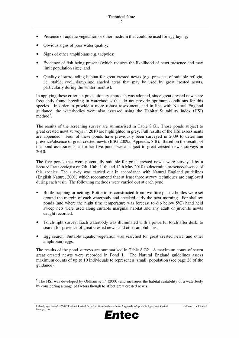
• Presence of aquatic vegetation or other medium that could be used for egg laying;
• Obvious signs of poor water quality;
• Signs of other amphibians e.g. tadpoles;
• Evidence of fish being present (which reduces the likelihood of newt presence and may
limit population size); and
• Quality of surrounding habitat for great crested newts (e.g. presence of suitable refugia,
i.e. stable, cool, damp and shaded areas that may be used by great crested newts,
particularly during the winter months).
In applying these criteria a precautionary approach was adopted, since great crested newts are
frequently found breeding in waterbodies that do not provide optimum conditions for this
species. In order to provide a more robust assessment, and in line with Natural England
guidance, the waterbodies were also assessed using the Habitat Suitability Index (HSI)
method5.
The results of the screening survey are summarised in Table 8.G1. Those ponds subject to
great crested newt surveys in 2010 are highlighted in grey. Full results of the HSI assessments
are appended. Four of these ponds have previously been surveyed in 2009 to determine
presence/absence of great crested newts (BSG 2009a, Appendix 8.B). Based on the results of
the pond assessments, a further five ponds were subject to great crested newts surveys in
2010.
The five ponds that were potentially suitable for great crested newts were surveyed by a
licensed Entec ecologist on 7th, 10th, 11th and 12th May 2010 to determine presence/absence of
this species. The survey was carried out in accordance with Natural England guidelines
(English Nature, 2001) which recommend that at least three survey techniques are employed
during each visit. The following methods were carried out at each pond:
• Bottle trapping or netting: Bottle traps constructed from two litre plastic bottles were set
around the margin of each waterbody and checked early the next morning. For shallow
ponds (and where the night time temperature was forecast to dip below 5ºC) hand held
sweep nets were used along suitable marginal habitat and any adult or juvenile newts
caught recorded.
• Torch-light survey: Each waterbody was illuminated with a powerful torch after dusk, to
search for presence of great crested newts and other amphibians.
• Egg search: Suitable aquatic vegetation was searched for great crested newt (and other
amphibian) eggs.
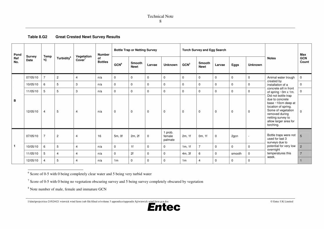
The results of the pond surveys are summarised in Table 8.G2. A maximum count of seven
great crested newts were recorded in Pond 1. The Natural England guidelines assess
maximum counts of up to 10 individuals to represent a ‘small’ population (see page 28 of the
guidance).
5 The HSI was developed by Oldham et al. (2000) and measures the habitat suitability of a waterbody
by considering a range of factors though to affect great crested newts.
Technical Note
3
l:\data\projects\ea-210\24421 winwick wind farm (sub file)\final es\volume 3 appendices\appendix 8g\winwick wind farm gcn.doc © Entec UK Limited
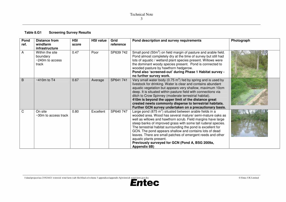
Table 8.G1 Screening Survey Results
Pond ref.
Distance from windfarm infrastructure
HSI score
HSI value Grid reference
Pond description and survey requirements Photograph
A
Within the site boundary ~240m to access track
0.47 Poor SP639 742 Small pond (50m2) on field margin of pasture and arable field.
Pond almost completely dry at the time of survey but still had lots of aquatic / wetland plant species present. Willows were the dominant woody species present. Pond is connected to wooded pasture by hawthorn hedgerow. Pond also ‘screened-out’ during Phase 1 Habitat survey - no further survey work.
B ~410m to T4 0.67 Average SP641 741 Very small water body (0.75 m2) fed by spring and is used by
livestock for drinking. Water is clear and contains abundant aquatic vegetation but appears very shallow, maximum 10cm deep. It is situated within pasture field with connections via ditch to Crow Spinney (moderate terrestrial habitat). 410m is beyond the upper limit of the distance great crested newts commonly disperse to terrestrial habitats. Further GCN survey undertaken on a precautionary basis.
C
On site ~30m to access track
0.80 Excellent SP640 747 Large pond (875 m2) situated between arable fields in a
wooded area. Wood has several mature/ semi-mature oaks as well as willows and hawthorn scrub. Field margins have large steep banks of improved grass with some tall ruderal species. The terrestrial habitat surrounding the pond is excellent for GCN. The pond appears shallow and contains lots of dead leaves. There are small patches of emergent reeds and other aquatic plants present. Previously surveyed for GCN (Pond A, BSG 2009a, Appendix 8B)

Technical Note
4
l:\data\projects\ea-210\24421 winwick wind farm (sub file)\final es\volume 3 appendices\appendix 8g\winwick wind farm gcn.doc © Entec UK Limited
Pond ref.
Distance from windfarm infrastructure
HSI score
HSI value Grid reference
Pond description and survey requirements Photograph
D
On site ~25m to access track
0.50 Below average
SP641 747 Small, shallow pond (48 m2) within wooded area between
arable field, woody species include oak, willow and hawthorn. Pond is coloured/turbid and contains algae. Previously surveyed for GCN (Pond D, BSG 2009a, Appendix 8B) - one torch survey and terrestrial search for GCN undertaken but determined it was unsuitable – no further survey work.
E On site ~100m to T3
0.35 Poor SP644 746 Very small pond (15 m2) situated within hedgerow between two
arable fields (rape seed). Hedgerow is dominated by hawthorn with occasional semi mature to juvenile oaks. Arable field margins are with (~4m) consisting of improved grass. Pond was almost dry at the time of survey, 100% shaded by hedge. Likely to be unsuitable to support GCN. No further survey work.
1 ~445m to T2 0.76 Good SP638 753 Medium sized (144 m2) pond situated within a golf course.
Water is clear and contains lots of aquatic vegetation. Pond is surrounded by short cut grassland. Woodland is nearby providing good terrestrial habitat. 445m is beyond the upper limit of the distance great crested newts commonly disperse to terrestrial habitats. Further GCN survey undertaken on a precautionary basis.
2 ~400m to T2 - - SP637 752 Dry at time of survey. Moist boggy ground present but no water present for breeding GCN. Rushes and other wetland plant species present. No further survey work required.
Technical Note
5
l:\data\projects\ea-210\24421 winwick wind farm (sub file)\final es\volume 3 appendices\appendix 8g\winwick wind farm gcn.doc © Entec UK Limited
Pond ref.
Distance from windfarm infrastructure
HSI score
HSI value Grid reference
Pond description and survey requirements Photograph
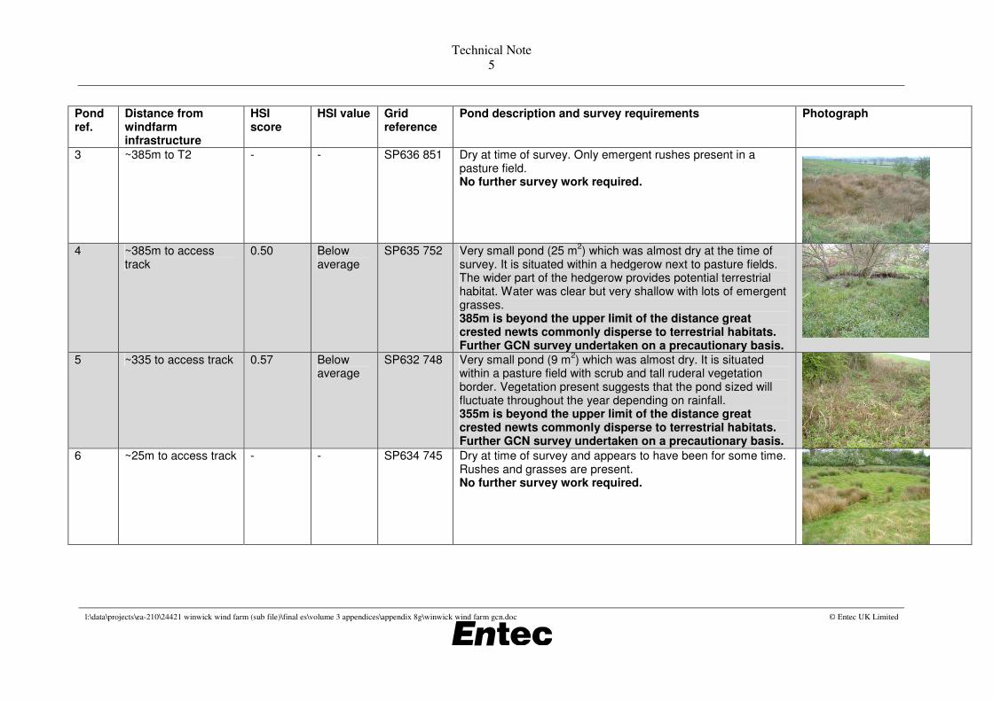
3 ~385m to T2 - - SP636 851 Dry at time of survey. Only emergent rushes present in a pasture field. No further survey work required.
4 ~385m to access
track 0.50 Below
average SP635 752 Very small pond (25 m
2) which was almost dry at the time of
survey. It is situated within a hedgerow next to pasture fields. The wider part of the hedgerow provides potential terrestrial habitat. Water was clear but very shallow with lots of emergent grasses. 385m is beyond the upper limit of the distance great crested newts commonly disperse to terrestrial habitats. Further GCN survey undertaken on a precautionary basis.
5 ~335 to access track 0.57 Below average
SP632 748 Very small pond (9 m2) which was almost dry. It is situated
within a pasture field with scrub and tall ruderal vegetation border. Vegetation present suggests that the pond sized will fluctuate throughout the year depending on rainfall. 355m is beyond the upper limit of the distance great crested newts commonly disperse to terrestrial habitats. Further GCN survey undertaken on a precautionary basis.
6
~25m to access track - - SP634 745 Dry at time of survey and appears to have been for some time. Rushes and grasses are present. No further survey work required.

Technical Note
6
l:\data\projects\ea-210\24421 winwick wind farm (sub file)\final es\volume 3 appendices\appendix 8g\winwick wind farm gcn.doc © Entec UK Limited
Pond ref.
Distance from windfarm infrastructure
HSI score
HSI value Grid reference
Pond description and survey requirements Photograph
7 ~12m to access track 0.39 Poor SP633 744 Very small pond (15 m2) which was almost dry. Pond is
situated within a hedgerow between pasture fields offering good terrestrial habitat. Water appears ~5cm deep with few emergent aquatic plants. Large old ash tree next to pond has good potential for bat roots. Likely to be unsuitable to support GCN. No further survey work.
8 ~35m to access track - - SP646 745 Dry at time of survey No further survey work required.
No photo
9 ~265m to access track
- - SP648 744 Dry at time of survey No further survey work required.
No photo
10 ~145m to access track
- - SP647 743 Dry at time of survey No further survey work required.
No photo
11 ~120m to access track
0.59 Below average
SP645 742 Small pond (120 m2) situated within arable field (oil seed rape)
surrounded by species-poor hedgerow and small patches of scrub containing several semi mature oaks. Road nearby is unlikely to be a barrier to newt dispersal. Pond has shallow banks and is shaded. The water contains lots of algae. Further GCN survey undertaken.
12
~470m to access track
0.69 Average SP643 739 Very small water body (36 m2) with lots of aquatic vegetation. It
is situated within pasture field bordering a wooded area (Warren Covert), which provides good potential terrestrial habitat for newts. Previously surveyed for GCN (Pond B, BSG 2009a, Appendix 8B)

Technical Note
7
l:\data\projects\ea-210\24421 winwick wind farm (sub file)\final es\volume 3 appendices\appendix 8g\winwick wind farm gcn.doc © Entec UK Limited
Pond ref.
Distance from windfarm infrastructure
HSI score
HSI value Grid reference
Pond description and survey requirements Photograph
13
~275m to access track
0.61 Average SP632 738 Medium-sized pond (225 m2) on a hedgerow in a pasture field.
It is used by cattle for drinking. Water is turbid and supports little aquatic vegetation. Signs of waterfowl activity were observed. Previously surveyed for GCN (Pond A, BSG 2009a, Appendix 8B)
Technical Note
8
l:\data\projects\ea-210\24421 winwick wind farm (sub file)\final es\volume 3 appendices\appendix 8g\winwick wind farm gcn.doc © Entec UK Limited
Table 8.G2 Great Crested Newt Survey Results
Bottle Trap or Netting Survey Torch Survey and Egg Search
Pond Ref No.
Survey Date
Temp ºC
Turbidity6
Vegetation Cover
7
Number of Bottles
GCN8
Smooth Newt
Larvae Unknown GCN3
Smooth Newt
Larvae Eggs Unknown
Notes Max GCN Count
07/05/10 7 2 4 n/a 0 0 0 0 0 0 0 0 0 0
10/05/10 6 5 3 n/a 0 0 0 0 0 0 0 0 0 0
11/05/10 5 5 3 n/a 0 0 0 0 0 0 0 0 0 0
B
12/05/10 4 5 4 n/a 0 0 0 0 0 0 0 0 0
Animal water trough created by installation of a concrete sill in front of spring ~3m x 1m. Did not bottle trap due to concrete base ~10cm deep at location of spring. Some of vegetation removed during netting survey to allow larger area for torching.
0
07/05/10 7 2 4 16 5m, 0f 2m, 2f 0 1 prob. female
palmate
2m, 1f 0m, 1f 0 2gcn - 5
10/05/10 6 5 4 n/a 0 1f 0 0 1m, 1f 7 0 0 0 2
11/05/10 5 4 4 n/a 0 2f 0 0 4m, 3f 6 0 smooth 0 7
1
12/05/10 4 5 4 n/a 1m 0 0 0 1m 4 0 0 0
Bottle traps were not used for last 3 surveys due to potential for very low overnight temperatures this
week. 1
6 Score of 0-5 with 0 being completely clear water and 5 being very turbid water
7 Score of 0-5 with 0 being no vegetation obscuring survey and 5 being survey completely obscured by vegetation
8 Note number of male, female and immature GCN

Technical Note
9
l:\data\projects\ea-210\24421 winwick wind farm (sub file)\final es\volume 3 appendices\appendix 8g\winwick wind farm gcn.doc © Entec UK Limited
Bottle Trap or Netting Survey Torch Survey and Egg Search
Pond Ref No.
Survey Date
Temp ºC
Turbidity6
Vegetation Cover
7
Number of Bottles
GCN8
Smooth Newt
Larvae Unknown GCN3
Smooth Newt
Larvae Eggs Unknown
Notes Max GCN Count
07/05/10 7 4 5 (95%) n/a 0 0 0 0 0 0 0 0 0 0
10/05/10 6 5 5 n/a 0 0 0 0 0 0 0 0 0 0
11/05/10 5 4 5 n/a 0 0 0 0 0 0 0 0 0 0
4
12/05/10 4 4 5 n/a 0 0 0 0 0 0 0 0 0
Too shallow for bottle trapping (10cm). The entire area was completely choked with flote grass. High turbidity meant that torching was very hard and ineffective. Netted and egg searched
the pond
0
07/05/10 7 2 5 (100%) n/a 0 0 0 0 0 0 0 0 - 0
10/05/10 6 5 5 n/a 0 0 0 0 0 1f 0 Smooth 0 0
11/05/10 5 4 5 n/a 0 0 0 0 0 2 0 0 1 0
5
12/05/10 4 4 5 n/a 0 0 0 0 0 0 0 Smooth 0
Too shallow for bottle trapping (15cm). High coverage of Typha and Lemna minor together with a high turbidity level meant that torching was largely ineffective. Netted and egg
searched the pond.
0
07/05/10 7 2 4 10 0 0 0 0 0 0 0 2 smooth/palmate
- 0
10/05/10 6 3 3 n/a 0 0 0 0 0 0 0 0 0 0
11/05/10 5 3 3 n/a 0 0 0 0 0 0 0 0 0 0
11
12/05/10 4 2 3 n/a 0 0 0 0 0 0 0 0 0
Bottle traps were not used for last 3 surveys due to potential for very low overnight temperatures this
week. 0

l:\data\projects\ea-210\24421 winwick wind farm (sub file)\24421 winwick es final.doc © Entec UK Limited May 2010
Appendix 8.H Ecology survey update: boundary survey

l:\data\projects\ea-210\24421 winwick wind farm (sub file)\24421 winwick es final.doc © Entec UK Limited May 2010
Technical Note 1
Ecology survey update: boundary survey
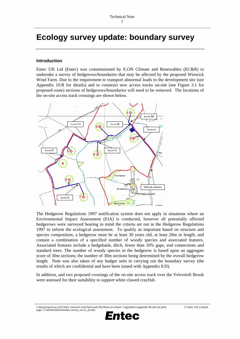
Introduction
Entec UK Ltd (Entec) was commissioned by E.ON Climate and Renewables (EC&R) to undertake a survey of hedgerows/boundaries that may be affected by the proposed Winwick Wind Farm. Due to the requirement to transport abnormal loads to the development site (see Appendix 10.B for details) and to construct new access tracks on-site (see Figure 3.1 for proposed route) sections of hedgerows/boundaries will need to be removed. The locations of the on-site access track crossings are shown below.
The Hedgerow Regulations 1997 notification system does not apply in situations where an Environmental Impact Assessment (EIA) is conducted, however all potentially affected hedgerows were surveyed bearing in mind the criteria set out in the Hedgerow Regulations 1997 to inform the ecological assessment. To qualify as important based on structure and species composition, a hedgerow must be at least 30 years old, at least 20m in length, and contain a combination of a specified number of woody species and associated features. Associated features include a hedgebank, ditch, fewer than 10% gaps, end connections and standard trees. The number of woody species in the hedgerow is based upon an aggregate score of 30m sections; the number of 30m sections being determined by the overall hedgerow length. Note was also taken of any badger setts in carrying out the boundary survey (the results of which are confidential and have been issued with Appendix 8.D).
In addition, and two proposed crossings of the on-site access track over the Yelvertoft Brook were assessed for their suitability to support white clawed crayfish.
l:\data\projects\ea-210\24421 winwick wind farm (sub file)\final es\volume 3 appendices\appendix 8h (do not print page 5 confidential)\boundary survey_rev jc_jm.doc
© Entec UK Limited
Technical Note 2
Results of Boundary Survey
No hedgerows surveyed would qualify as important under the Hedgerow Regulations 1997 based on structure and species composition, but in all cases where hedgerows need to be removed nesting birds should be considered.
A5199/Nortoft (Appendix 10.B) Hedge/tree line which may need to be trimmed back to accommodate abnormal loads. The majority of the vegetation identified on the roadside is blackthorn ~1.5m-3m high. Behind the blackthorn are young ash and beech trees ~4m high, forming part of a small deciduous woodland behind the blackthorn. Woodland comprises dense dogs mercury in ground flora, also mature beech trees (~5m from road side) with branches overhanging into the roadside blackthorn vegetation. No evidence of badger was identified within 30m of the road for the length of hedge/wood between the two adjoining side roads.
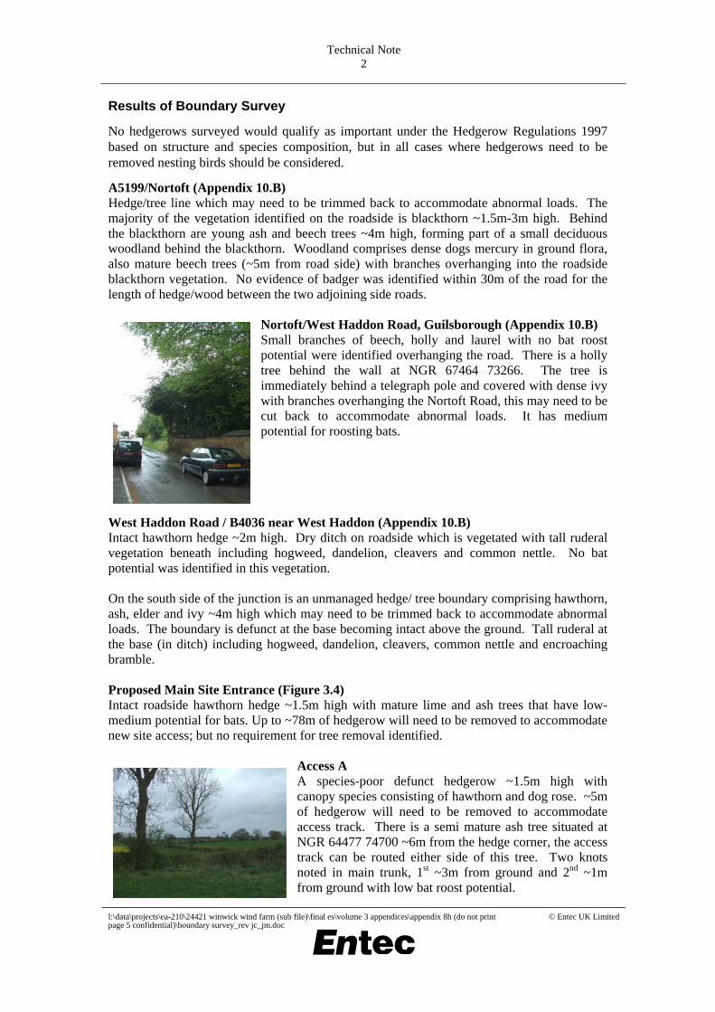
Nortoft/West Haddon Road, Guilsborough (Appendix 10.B) Small branches of beech, holly and laurel with no bat roost potential were identified overhanging the road. There is a holly tree behind the wall at NGR 67464 73266. The tree is immediately behind a telegraph pole and covered with dense ivy with branches overhanging the Nortoft Road, this may need to be cut back to accommodate abnormal loads. It has medium potential for roosting bats.
West Haddon Road / B4036 near West Haddon (Appendix 10.B) Intact hawthorn hedge ~2m high. Dry ditch on roadside which is vegetated with tall ruderal vegetation beneath including hogweed, dandelion, cleavers and common nettle. No bat potential was identified in this vegetation. On the south side of the junction is an unmanaged hedge/ tree boundary comprising hawthorn, ash, elder and ivy ~4m high which may need to be trimmed back to accommodate abnormal loads. The boundary is defunct at the base becoming intact above the ground. Tall ruderal at the base (in ditch) including hogweed, dandelion, cleavers, common nettle and encroaching bramble. Proposed Main Site Entrance (Figure 3.4) Intact roadside hawthorn hedge ~1.5m high with mature lime and ash trees that have low-medium potential for bats. Up to ~78m of hedgerow will need to be removed to accommodate new site access; but no requirement for tree removal identified.
Access A A species-poor defunct hedgerow ~1.5m high with canopy species consisting of hawthorn and dog rose. ~5m of hedgerow will need to be removed to accommodate access track. There is a semi mature ash tree situated at NGR 64477 74700 ~6m from the hedge corner, the access track can be routed either side of this tree. Two knots noted in main trunk, 1st ~3m from ground and 2nd ~1m from ground with low bat roost potential.
l:\data\projects\ea-210\24421 winwick wind farm (sub file)\final es\volume 3 appendices\appendix 8h (do not print page 5 confidential)\boundary survey_rev jc_jm.doc
© Entec UK Limited

Technical Note 3
l:\data\projects\ea-210\24421 winwick wind farm (sub file)\final es\volume 3 appendices\appendix 8h (do not print page 5 confidential)\boundary survey_rev jc_jm.doc
© Entec UK Limited
ss to the south side of this area, therefore no impact upon this vegetation in nticipated).
ramble and elder. ~5m of hedgerow will need to be removed to ccommodate access track.
is required to accommodate access track. No potential r white clawed crayfish identified.
ain ~5m wide to south east end ntially be used for access.
to be removed to accommodate
or other may need to be removed to ccommodate access track. Tree at NGR 64276 674962 has ivy on the trunk but it is not
gh for roosting bats.
edge is managed (~1m high) intact hawthorn, Acer species, elder and blackthorn. ~5m of
rack. No potential for white lawed crayfish. Potential for kingfisher/ sand martin burrows in earth bank – check will be
nesting birds before construction works commence.
access through intact hawthorn and blackthorn managed hedgerow ~1.5m high. 1.5m of this hedgerow may need to be removed to accommodate required access width of
efunct hedge with canopy species comprising hawthorn, elder and field maple. ~5m of will need to be removed to accommodate access track.
rge existing gap and machine access ~15m-20m wide at eastern end of hedge which could potentially be used for access.
Access Bi Dense blackthorn growth in field corner and two trees with bat potential (on-site access track appears to croa Hedgerow ~2m high, managed, intact (some parts of base defunct) with species comprising ash, hawthorn, blackthorn, ba Stream with silty base, ~0.5m wide, ~15cm deep (maximum) with a slow flow and bordered by meadow sweet. Culvert installationfo Access Bii Existing gap in hedgerow with brick and pipe crossing over drof this boundary which could pote
Hedge is managed, ~1m high, with canopy species comprising hawthorn, elder, field maple, dog rose and blackthorn. Ash tree at NGR 64291 74950 with top blown out and large cavity down branch on eastern side has high bat roost potential. ~5m of hedgerow northwest of this ash tree will need access track.
Two young ash trees in hedgerow to northwest at NGR 64276 674962 and NGR 64288 674959 have low bat roost potential but oneadense enou Access Ci Hhedgerow will need to be removed to accommodate access track. Stream with gravel/silty base ~0.5m wide with steep sides; south side bank collapsed in places. Culvert installation is required to accommodate access tcrequired for Access Cii Existing~5m. Access D Dhedgerow Access E La

Technical Note 4
l:\data\projects\ea-210\24421 winwick wind farm (sub file)\final es\volume 3 appendices\appendix 8h (do not print page 5 confidential)\boundary survey_rev jc_jm.doc
© Entec UK Limited
Hedge at access point crossing is defunct hawthorn, dog rose, cherry, elder, bramble and ash with three young trees (one cherry and two ash) having no roosting potential for bats. ~5m of hedgerow will need to be removed to accommodate access track.

l:\data\projects\ea-210\24421 winwick wind farm (sub file)\24421 winwick es final.doc © Entec UK Limited May 2010
Appendix 8.I Outline habitat improvement plan

l:\data\projects\ea-210\24421 winwick wind farm (sub file)\24421 winwick es final.doc © Entec UK Limited May 2010

Winwick Wind Farm
Ecological Enhancement Plan (Outline)
May 2010

ISSUING OFFICE:
Arden House Deepdale Business Park
Ashford Road Bakewell
Derbyshire DE45 1GT
TEL: 01629 815544
FAX: 01629 815577
Web: www.bsg-ecology.com Email: [email protected] Offices in: Bakewell, Oxford, Berwick-upon-Tweed & Monmouth
Registered in: Cardiff No. OC328772 Registered address: Arden House Deepdale Business Park Ashford Road Bakewell Derbyshire DE45 1GT
Members: A list of members is available at each office.
Client E.ON Ltd
Job Name Winwick Wind Farm
Report title Ecological Enhancement Plan
File reference
3844 06_008_final_eep_kv_DB_(05 05 10)_EM_FINAL.doc
Signed Name Position Date
Originated Dr Kate Vincent Senior Ecologist 11/04/10
Reviewed Philippa Harvey Principal Ecologist 13/04/10
Revised Dr Kate Vincent Senior Ecologist 05/05/10

3844 06_008_final_eep_kv_DB_(05 05 10)_EM_FINAL.doc Page 1
Report Contents
1 Introduction .......................................................................................2
1.1 Site Description................................................................................................ 2
1.2 Proposed work ................................................................................................. 2
1.3 Aims ................................................................................................................. 2
2 Biodiversity Character Assessment.......................................................3
2.1 Background ...................................................................................................... 3
2.2 Winwick Biodiversity Character Assessment .................................................... 3
2.2.1 Acid Sands Biodiversity Character Type..........................................................3 2.2.2 Key habitat features at Winwick .................................................................... 4 2.2.3 Biodiversity enhancement opportunities at Winwick ..................................... 6
2.3 Green Infrastructure ......................................................................................... 8
3 Ecological Enhancement Plan ............................................................ 10
3.1 Management Prescriptions ............................................................................ 10
3.1.1 Woodland .....................................................................................................10 3.1.2 Grassland......................................................................................................10 3.1.3 Hedgerows ................................................................................................... 11 3.1.4 Ponds............................................................................................................ 11 3.1.5 Ditch/Stream management ..........................................................................12 3.1.6 Beetle Banks .................................................................................................12 3.1.7 Farmland birds..............................................................................................12 3.1.8 Other species................................................................................................14 3.1.9 SUDS ............................................................................................................14 3.1.10 Decommissioning .........................................................................................14 3.1.11 Monitoring....................................................................................................14
Appendix 1............................................................................................ 18
Figure 1: Site Plan and Habitat Map ........................................................................ 18
Figure 2.1 Ecological Management Prescriptions: Year 1 ........................................ 18
Figure 2.2 Ecological Management Prescriptions: Ongoing.................................... 18
Appendix 2: Planting / seed mix specifications.......................................... 19
3844 06_008_final_eep_kv_DB_(05 05 10)_EM_FINAL.doc Page 2
1 Introduction
1.1 Site Description
The site is composed of two working farms, located to the north east of Winwick village in
Northamptonshire, centred at National Grid Reference (NGR) E464046 N2744687. The B4036 road is
situated adjacent to the eastern site boundary, and the remainder of the site is bounded by further
farmland.
The site consists of a series of arable and improved grassland fields, with occasional field margins. Field
boundaries are frequently formed by hedgerows, with occasional drainage ditches. A number of farm
buildings and associated hard standing access tracks are located to the east of the site. Warren Covert, an
area of mature mixed woodland, is present to the south of the site. In addition, a number of small areas of
plantation broadleaved woodland are present throughout the site.
1.2 Proposed work
The proposed work involves the construction of a seven turbine wind farm, a permanent meteorological
mast, a substation compound plus associated site infrastructure including access tracks.
1.3 Aims
The ecological consultancy Baker Shepherd Gillespie was commissioned by E.ON Climate and Renewables
UK Developments Ltd (EC&R) to prepare an Ecological Enhancement Plan (EEP) of the proposed
development site.
This Ecological Enhancement Plan has two primary aims:
� to deliver biodiversity enhancement which will contribute to both local and strategic biodiversity
objectives.
� to deliver the development of Green Infrastructure. Projects which involve the protection and
enhancement of ecological features (and as a consequence contribute to the maintenance of
ecosystems) have an opportunity to contribute to a green infrastructure network of multi-
functional green spaces and interconnecting links.
This document comprises two separate sections. The first section is a Biodiversity Character Assessment.
This section evaluates the site and features within the site in relation to the objectives of the
Northamptonshire Biodiversity Character Strategy1. It also discusses how the project will contribute to
Green Infrastructure within the context of the local area.
The second section is the Ecological Enhancement Plan which details the ecological measures which will
achieve the stated aims of conserving and enhancing biodiversity and green infrastructure within the site.
The Ecological Enhancement Plan is only an outline document at this stage and provides potential ideas
for ecological improvement. This document could be subject to post consent consultations and
amendments and is seen as an evolving document. The suggestions for improvement within the EEP do
not need to be and have not been assessed in the ES and this should be seen as a stand alone document.
The UK Biodiversity Action Plan2 (UK BAP) sets out a programme for conserving biodiversity in the UK and
will be used to inform this EEP. The UK BAP has published lists of species and habitats that are
conservation priorities which are under threat because of their rarity and rate of decline.
1 Weblink: www.rnrenvironmentalcharacter.org.uk (Northamptonshire’s Environmental & Green Infrastructure Suite) April 2009.
2 www.ukbap.org.uk

3844 06_008_final_eep_kv_DB_(05 05 10)_EM_FINAL.doc Page 3
2 Biodiversity Character Assessment
2.1 Background
The Northamptonshire Biodiversity Character Strategy1 considers the character and distinctiveness of
Northamptonshire's biodiversity, describing each of the county's component biodiversity character types
and biodiversity character areas. It is a landscape scale approach to conserving and enhancing biodiversity.
The Northamptonshire Biodiversity Action Plan3 helps to inform the Strategy by identifying priority
habitats and priority species for conservation and enhancement. Through a Biodiversity Character
Assessment, the Northamptonshire Biodiversity Character Strategy identifies the areas where these
habitats exist and where there is potential for their creation or restoration.
The Northamptonshire Biodiversity Character Strategy involves the following principles:
� A landscape scale approach will be taken to conserve and enhance biodiversity, whereby, for each
biodiversity character type, all characteristic habitats should be conserved, restored extended,
buffered and linked.
� Where no, or limited areas of characteristic habitats are retained the creation of new areas of
characteristic habitats will be encouraged and opportunities for creating new habitats should be
explored.
� Habitat restoration and creation schemes should seek to create large-scale mosaics of semi-
natural habitats that function as sustainable ecosystems and reinforce biodiversity character, as
well as being based on up-to-date ecological information and specialist ecological advice.
2.2 Winwick Biodiversity Character Assessment
2.2.1 Acid Sands Biodiversity Character Type
Winwick is situated within the Guilsborough and Spratton area. This area is identified in the Biodiversity
Character Strategy as one of a number of areas throughout Northamptonshire which are of the “Acid
Sands Biodiversity Character Type”. This character type occupies the highest elevations principally in the
west of Northamptonshire and the variety of soil types represents the changes in underlying geology.
Well-drained, fine and coarse loamy ferritic brown earth soils overlie the Northampton Sand Formation
and slightly stony, sandy loam soils are common, particularly on the higher ground.
The Acid Sands Biodiversity Character Type comprises “fragmented areas of broadleaved and mixed
woodland, much of which is of ancient origin, although the proportion of woodland varies across the
Biodiversity Character Areas. Occasional areas of lowland acid grassland occur mainly on the steepest slopes
and lowland neutral grassland is mainly confined to man-made sites. Overall the survival of semi-natural
habitats is low.”
The Northamptonshire Biodiversity Character Strategy identifies six key habitats within the Acid Sands
Biodiversity Character type. These are:
� Lowland neutral grassland
“Slightly acidic Lowland Neutral Grasslands would once have been widespread on the clay soils.
……However, due to agricultural improvement, neutral grasslands are only retained on man-made sites.”
3 Northamptonshire Biodiversity Partnership (2008) Northamptonshire Biodiversity Action Plan 2nd Edition. Northampton.

3844 06_008_final_eep_kv_DB_(05 05 10)_EM_FINAL.doc Page 4
� Lowland acid grassland
“Acid grasslands are more widespread than heathland, but are limited in number. They tend to be found
on the slopes of hillsides where the Northampton Sand Formation lies over clay. Here rainwater filters
through the sandstone leaving well-drained soils.”
� Lowland mixed woodland
“Woodlands are generally fragmented but much that remains is of ancient origin….. The two main
woodland types are oak - bracken - bramble woods on the sandy soils and ash - field maple woods over
the clay soils …….Many replanted sites have a significant conifer component.”
� Lowland heathland
“The only extensive heathland occurs over the sandiest soils in the vicinity of Harlestone Firs in the
Harlestone and Brampton Heaths Biodiversity Character Area, northwest of Northampton. However, the
heaths area is heavily affected by the planting of conifers.”
� Hedgerows
“Grasslands tend to be bounded by stock proof hedges, which provide food and shelter for a wide variety
of species and forming the basis of important wildlife corridors. However, in arable areas, many
hedgerows have been removed to allow more efficient crop management and where hedges are retained
they often form low, discontinuous boundary features of limited biodiversity value.”
• Open standing water (field ponds, ornamental lakes and sections of canal)
“There are some concentrations of field ponds and occasional ornamental lakes on the clays of the Whitby
Mudstone Formation, although few are designated as Wildlife Sites. The Grand Union Canal is also a
feature of the Litchborough and Pattishall Biodiversity Character Area, providing an important wildlife
corridor in association with the adjacent grassland and hedgerows.”
In summary, within the Acid Sands Biodiversity Character Type, biodiversity can be enhanced by the
restoration, creation, buffering and linkage of broad-leaved woodland, lowland neutral or acid grassland,
hedgerows and open standing water to create large sustainable mosaics of characteristic habitats. Habitat
fragmentation should be further reduced through the conservation, restoration and buffering of
hedgerows to create functioning wildlife corridors. The strategy does not refer to specific measures
targeted towards individual species.
2.2.2 Key habitat features at Winwick
The paragraphs below describe the key habitat features which currently exist within the site. They should
be read with reference to the Site Map and Habitat Plan (Figure 1, Appendix 1).
Arable fields
Arable fields occur throughout the majority of the southern section of the site. The arable fields have
neutral grassland field margins of varying widths, with patches of tall ruderal vegetation. Species present
include false oat-grass Arrhenatherum elatius, cock’s-foot Dactylis glomerata, perennial rye-grass Lolium
perenne, red fescue Festuca rubra, creeping thistle Cirsium arvense, creeping buttercup Ranunculus repens,
broadleaved dock Rumex obtusifolius, great plantain Plantago major, with occasional compact rush Juncus
conglomeratus in the damper areas.
Grassland
The northern section of the site is predominantly composed of improved grassland fields, with two semi-
improved grassland fields. The improved grasslands are species-poor, dominated by perennial rye-grass,
with occasional white clover Trifolium repens and creeping buttercup. Tufted hair-grass Deschampsia
cespitosa, crested dog’s-tail Cynosurus cristatus and creeping thistle are occasionally present on the
steeper slopes. The semi-improved grassland fields are of a similar species composition, with markedly
less perennial rye-grass present in the sward. These fields are grazed by cattle and sheep.

3844 06_008_final_eep_kv_DB_(05 05 10)_EM_FINAL.doc Page 5
Woodland
There are three areas of broad-leaved woodland located within the development site boundary at National
Grid References SP 636 744; SP640 747; and SP641 747. There is also a small localised area of broad-leaved
plantation connected to a hedgerow in the south western part of the development site.
There are also areas of woodland outside the development site, bordering the eastern and south-eastern
development site boundaries, including Warren Covert, which is a mature mixed plantation located
immediately adjacent to, but outside, the development site’s south east boundary. The canopy is mixed in
age and structure, and is generally continuous. Canopy species present include ash Fraxinus excelsior,
horse chestnut Aesculus hippocastanum, silver birch Betula pendula, holly Ilex aquifolium, elder and hazel
Corylus avellana. The shrub layer is discontinuous, and generally composed of regenerating trees. The
ground flora, where present, is species-poor, predominantly composed of Yorkshire fog Holcus lanatus,
with occasional common nettle Urtica dioica and young bramble, with isolated tussocks of tufted hair-
grass. Deadwood and occasional rubble piles are present throughout this woodland. The northern half of
the woodland is more open, located on a south-facing slope, with little shrub layer present. Here the
ground flora is sparse, with occasional foxglove Digitalis purpurea.
The southern boundary of the woodland is formed by a small stream, flowing in a westerly direction. The
channel width is variable, between 0.5 – 2 metres wide, with a sandy substrate, a high level of leaf litter
and exposed mud. The water was approximately 3cm deep at the time of survey. The banks are generally
composed of exposed earth, with occasional vegetation present. Further west, the stream is densely
overhung by hawthorn and bramble.
Crow Spinney is a broadleaved plantation, which also borders the development site’s south east boundary.
Hedgerows
The majority of the field boundaries are formed by species-poor hedgerows with occasional trees.
Hawthorn Crataegus monogyna is the dominant species throughout, with frequent blackthorn Prunus
spinosa and elder Sambucus nigra. Occasional species present include field maple Acer campestre, hazel,
rose Rosa sp., and bramble Rubus fruticosus agg.. There are occasional mature ash Fraxinus excelsior and
pedunculate oak Quercus robur trees present. The hedgerows are variable throughout the study site, and
some are more actively managed, therefore providing diversity in height.
There is a species-rich hedgerow located within the northern section of the site. Species present include
field maple, elder, hawthorn, bramble, ash, blackthorn, crab apple Malus sylvestris and bracken Pteridium
aquilinum.
Wet ditches
There are a number of drainage ditches within the development site. These typically extend along field
boundaries at the base of hedgerows. The ditches are typically less than 1m wide with relatively steep,
vegetated banks and support marginal vegetation
These ditches are variable, and are generally less than one metre wide, with relatively steep, vegetated
banks. Marginal vegetation present within the channels includes soft rush Juncus effusus and tufted hair-
grass. The banks are generally dominated by tall ruderal vegetation, including common nettle Urtica
dioica, hedge woundwort Stachys sylvatica, hogweed Heracleum sphondyllium, creeping thistle and hedge
bindweed Calystegia sepium, with occasional dog rose Rosa canina agg., guelder-rose Viburnum opulus and
elder.
Ponds
There are three ponds (Pond A-C) located within the site and three ponds located within 150 metres of the
site; two which contain water (Pond E and F) and one pond that does not contain open water (Pond D).

3844 06_008_final_eep_kv_DB_(05 05 10)_EM_FINAL.doc Page 6
Pond A is located adjacent to an area of mature plantation broadleaved woodland, centred at OS grid
reference SP 640 747. The pond is approximately 25 metres x 20 metres, and the water is turbid. The banks
are steep and densely vegetated with tall ruderal vegetation including common nettle, cock’s-foot, false
oat-grass and willowherb Epilobium sp. Marginal vegetation is generally absent, restricted to a patch of
hard rush Juncus inflexus and brooklime Veronica beccabunga on the eastern pond margin. Arable fields
surround the pond in the wider area. Pond B is located approximately 110 metres to the east of Pond A
linked via a species-poor hedgerow with trees.
Pond B is located within an area of scrubby broadleaved woodland, centred at OS grid reference SP 641
747. The pond is approximately 5 metres x 5 metres. The pond is shallow, with a maximum depth of
approximately 50cm, and with shallow sloping banks. There is no marginal vegetation present. The pond is
completely shaded by the surrounding woodland. Arable fields surround the pond in the wider area.
Pond C is located at the base of a species-poor hedgerow, within a small stand of scrubby willow carr, in
the corner of two arable fields, centred at OS grid reference SP 639 742. The pond is limited to an area of
damp ground, with only occasional shallow pools of standing water. A wet ditch is located along the
northern limit of the pond. The pond’s marginal vegetation includes soft rush, brooklime, horsetail
Equisetum sp., Yorkshire fog, common nettle and creeping buttercup with occasional mosses. An improved
grassland field is located to the east of the pond, with arable fields situated to the north, south and west. A
species-poor hedgerow and wet ditch extend from the pond to the east and the west.
Pond D is located adjacent to the western site boundary within an improved grassland field, centred at OS
grid reference SP 634 745. The pond is approximately 10 metres x 10 metres, limited to an area of damp
ground with no open water present. Floating sweet-grass Glyceria fluitans and soft rush now cover the
surface of the pond. The banks of the pond are gently sloping, and grade into the surrounding improved
grassland habitat, with no distinct bankside vegetation present.
Pond E is located to the west of the site boundary, at the corner of two improved grassland fields, centred
at OS grid reference SP 632 738. The pond is approximately 13 metres x 8 metres, and the water is
relatively clear, with a maximum depth of approximately 1 metre at the time of survey. The eastern,
southern and western banks are steep, and the northern bank is gently-sloping. The marginal vegetation is
limited to the northern pond margin, where brooklime, willowherb and forget-me-not Myosotis sp. are
present. The pond is overhung by hawthorn and ash, which shade approximately 90% of the shores.
Species-poor hedgerows with trees are present to the south and west of the pond.
Pond F is located adjacent to the eastern boundary of Warren Covert at the base of a steep slope within an
improved grassland field, centred at OS grid reference SP 643 739. The pond is approximately 3 metres x 5
metres. The banks are steep and vegetated with species from the adjoining improved grassland field,
including perennial rye-grass and cock’s-foot. Brooklime is present at the margins of the pond.
Approximately 60% of the shore is shaded by a mature ash tree located on the eastern bank top, and by
overhanging holly and ash on the western bank.
UK BAP priority species found on site
There were eleven Priority species listed under the UK BAP2 that were found on site. These were skylark
Alauda arvensis, corn bunting Miliaria calandra, yellowhammer Emberiza citrinella, house sparrow Passer
domesticus, grey partridge Perdix perdix, starling Sturnus vulgaris, lapwing Vanellus vanellus and bullfinch
Pyrrhula pyrrhula as well as brown hare Lepus europaeus, common toad Bufo bufo and noctule bat Nyctalus
noctula. The Ecological Enhancement Plan’s recommended prescriptions will create and enhance foraging
or breeding habitats within the site for these priority species.
2.2.3 Biodiversity enhancement opportunities at Winwick
Given the existing character of the site, opportunities for enhancing biodiversity correspond well to a
number of objectives identified in the Northamptonshire Biodiversity Character Strategy and the local and
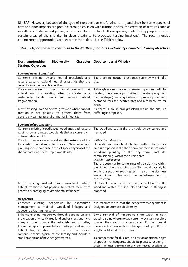
3844 06_008_final_eep_kv_DB_(05 05 10)_EM_FINAL.doc Page 7
UK BAP. However, because of the type of the development (a wind farm), and since for some species of
bats and birds impacts are possible through collision with turbine blades, the creation of features such as
woodland and dense hedgerows, which could be attractive to these species, could be inappropriate within
certain areas of the site (i.e. in close proximity to proposed turbine locations). The recommended
enhancement opportunities are set out in more detail in the Table 1 below:
Table 1: Opportunities to contribute to the Northamptonshire Biodiversity Character Strategy objectives
Northamptonshire Biodiversity Character
Strategy Objectives
Opportunities at Winwick
Lowland neutral grassland
Conserve existing lowland neutral grasslands and
restore existing lowland neutral grasslands that are
currently in unfavourable condition.
There are no neutral grasslands currently within the
site.
Create new areas of lowland neutral grassland that
extend and link existing sites to create large
sustainable habitat units and reduce habitat
fragmentation.
Although no new areas of neutral grassland will be
created, there are opportunities to create grassy field
margin strips (neutral grassland) to provide pollen and
nectar sources for invertebrates and a food source for
birds.
Buffer existing lowland neutral grassland where habitat
creation is not possible to protect them from
potentially damaging environmental influences.
As there is no neutral grassland within the site, no
buffering is proposed.
Lowland mixed woodland
Conserve existing broadleaved woodlands and restore
existing lowland mixed woodlands that are currently in
unfavourable condition.
The woodland within the site could be conserved and
managed.
Creation of new areas of woodland that extend and link
to existing woodlands to create. New woodland
planting should comprise a mix of species typical of the
characteristic ash-field maple woodlands.
Within the turbine area
No additional woodland planting within the turbine
area is proposed in the short term but there is proposed
woodland planting in the long term (post de-
commissioning) within the turbine area.
Outside Turbine area
There is potential for some areas of tree planting within
the site outside the turbine area. This could possibly be
within the south or south-eastern area of the site near
Warren Covert. This would be undertaken prior to
construction.
Buffer existing lowland mixed woodlands where
habitat creation is not possible to protect them from
potentially damaging environmental influences.
No threats have been identified in relation to the
woodland within the site. No additional buffering is
proposed.
Hedgerows
Conserve existing hedgerows by appropriate
management to maintain woodland linkages and
reduce habitat fragmentation.
It is recommended that the hedgerow management is
designed to promote biodiversity.
Enhance existing hedgerows through gapping up and
the creation of uncultivated land and/or grassland field
margins to encourage the establishment of taller,
thicker hedges, improve habitat linkages and reduce
habitat fragmentation. The species mix should
comprise species typical of the locality and include a
small proportion of new hedgerow trees.
Some removal of hedgerows (~5m width at each
crossing point where no gap currently exists) is required
to allow the creation of access tracks. Furthermore, at
the site entrance a section of hedgerow of up to 80m in
length could need to be removed.
To compensate for this loss, at least an additional 125m
of species-rich hedgerow should be planted, resulting in
better linkages between poorly connected sections of

3844 06_008_final_eep_kv_DB_(05 05 10)_EM_FINAL.doc Page 8
As the table above demonstrates, there are a number of opportunities to contribute towards the
objectives of the Northamptonshire Biodiversity Character Strategy, particularly in relation to field ponds
and hedgerows. In addition, there are opportunities to contribute to wider objectives of the UK and local
Biodiversity Action Plans in relation to farmland birds (e.g. yellowhammer Emberiza citrinella, linnet
Carduelis cannabina, reed bunting Emberiza schoeniclus and grey partridge Perdix prefix), through the
creation of wild bird seed mixture strips and hedgerow management, and for amphibians, through the
proposed pond restoration work.
2.3 Green Infrastructure
Green Infrastructure (GI) can be defined as “a network of multi-functional green spaces and interconnecting
links”4.
“At the strategic level, GI is an environmental system that supports the health, wellbeing and aesthetic values
of communities and the maintenance of functional ecosystems. It provides a process that makes the most of
existing and future assets, enables the environment to support and maintain natural processes, and sustains
land, air and water resources”4.
It is set within and contributes to a high quality natural and built environment and is required to deliver
“liveability” for new communities”1.
There is clearly a significant link between the objectives of the Biodiversity Character Strategy and the
development of Green Infrastructure, and projects which involve the protection and enhancement of
ecological features (and as a consequence contribute to the maintenance of ecosystems) have an
opportunity to contribute to both.
The proposed development site will provide a multi-functional green space. The site will be used to
generate clean and sustainable energy from wind power; it is used for food production; it supports
4 Weblink: www.rnrenvironmentalcharacter.org.uk (Northamptonshire’s Environmental & Green Infrastructure Suite) April 2009.
existing hedgerows and an overall increase in
hedgerows within the site.
Grassland field margins could be created along several
hedgerows within the site in combination with wild bird
seed mixture strips.
Open standing water (field ponds)
Conserve existing field and woodland ponds that are
currently in favourable condition.
The existing field ponds should be retained and
conserved within the site.
Restore field and woodland ponds that are currently in
unfavourable condition.
There is an opportunity for the four field ponds which
are currently in poor condition to be restored (ponds A,
B, C, and F).
Create buffer strips around field ponds to reduce the
impact of soil erosion and diffuse pollution.
It is recommended that where field ponds are directly
adjacent to arable land, grass margins should be
created around the ponds as a buffer.
Create new field and woodland ponds. No further field ponds are proposed.
Wildlife corridors
Enhance existing wildlife corridors along hedgerows
and streams which are beneficial to a wide range of
species, improve habitat linkages and reduce habitat
fragmentation.
The primary wildlife corridors within the site are
hedgerows. As set out above, the total length of
hedgerows should be increased and field margin habitat
creation will enhance the value of existing hedgerows
within the site.

3844 06_008_final_eep_kv_DB_(05 05 10)_EM_FINAL.doc Page 9
farmland biodiversity, including a number of UK Biodiversity Priority Species (farmland birds and hare) and
priority habitats (woodland, field ponds and hedgerows). Biodiversity should be retained, and in some
cases enhanced, within the site. In addition, as the site is farmland it provides open countryside close to
West Haddon and Cold Ashby.
The A14 dual carriageway to the north of the site and to a lesser extent, the A519 to the east of the site and
the A428 to the south, form a barrier to the dispersal of wildlife and limit opportunities for improving links
and connectivity with adjacent habitats. To the north and west, generally similar open arable farmland
habitats and occasional small blocks of woodland, continue for a number of kilometres. The site is not well
placed to link major groupings of habitat, such as the wetlands in the Nene valley or woodlands to the
north-east of Kettering. As a consequence, no obvious strategic linking function has been identified in
relation to the site.
In this type of highly fragmented arable landscape, the main opportunity for improving links should be
achieved at a more local scale though the maintenance and enhancement of hedgerows and woodland,
the retention and creation of features such as field ponds and hedgerows, and through contributing to the
other objectives identified for the Acid Sands Biodiversity Character Type (see above).
The next section of the report is an Ecological Enhancement Plan which sets out a programme for
delivering these opportunities to protect and enhance biodiversity within the site.

3844 06_008_final_eep_kv_DB_(05 05 10)_EM_FINAL.doc Page 10
3 Ecological Enhancement Plan
The approach takes into account important features on the farmland in particular biodiversity priorities. It
will take into account turbine layout and the creation of features in proximity to turbines to make sure the
risk of collision of bats and birds is avoided.
3.1 Management Prescriptions
Management prescriptions are set out below in relation to key habitat and species. These take the form of
explanatory text, tables detailing the specific management actions and plans showing the location of a
number of these management prescriptions. Figure 1 (in Appendix 1) details the current habitat areas
within the site and Figures 2.1 & 2.2 (in Appendix 1) highlight areas within the site that could be enhanced
for biodiversity with specific actions that should be undertaken at the initial stage, as well as details of
ongoing prescriptions respectively.
3.1.1 Woodland
Existing woodland habitats within the site will not be affected by the proposed development. However
there is potential to manage the existing woodland; Warren Covert and Crow Spinney to improve these
areas for wildlife.
3.1.1.1 Woodland edge management
The woodland edge should be allowed to grow out into the field edge through a 6m uncultivated strip
from edge of the wood.
3.1.1.2 Provision of a woodland creation
It is recommended that the planting of additional trees within the centre of the site (near the triangular
plantation) is not encouraged as an increase in connectivity could encourage bat use within the centre of
the wind farm.
Woodland creation away from the core wind farm area either at the southern edge of the site near to
Warren Covert, or in the north east section of the site is preferable. If an area is deemed suitable for tree
planting, the planting will start prior to wind farm construction.
Woodland planting near the existing triangular plantation should only be undertaken in the long-term
following the decommissioning phase.
3.1.2 Grassland
Due to the proposed site layout, impacts on the two areas of semi-improved and improved grassland
habitats will be avoided during the construction phase.
3.1.2.1 Grassland field margin creation
A wide field margin strip 500m long and 20m wide (1 hectare) has been proposed running east to west
along the southern hedge boundary of a field within the centre of the site (G2 Figure 2.1), adjacent to pond
B and south of turbine 2. In addition, 1710m of 6m (equating to 1.02ha) of wide grassland field margins
should be created adjacent to hedgerows. There is an opportunity for these margins to be sown with an
appropriate neutral grassland seed mixture. During the first year these margins should be cut four times
between May and August to promote the establishment of wild flowers.
Following establishment, the margins could be managed by cutting which should be carried out every two
years on a rotation basis from mid-July onwards. The cutting regime will allow the development of an
uneven sward and allow herbaceous species to flower. This will provide habitat and foraging areas suitable

3844 06_008_final_eep_kv_DB_(05 05 10)_EM_FINAL.doc Page 11
for insects and a variety of farmland birds and barn owl which is a local BAP listed species. A recommended
species mix is set out in Appendix 2.
3.1.3 Hedgerows
Some removal of hedgerows (~5m width at each crossing point where no gap currently exists) is required
to allow the creation of access tracks. Shrubs will be planted to compensate for those removed, using
native species of local provenance and reflecting the species-mix of the hedgerow.
Furthermore, at the site entrance a section of hedgerow of up to 80m in length could need to be removed.
This hedgerow is species-poor and incorporates a number of lime and ash trees. The removal of this
hedgerow and localised hedgerow crossings will be compensated for by the creation of hedgerows of
greater length at other locations within the site and gapping-up of existing hedgerows.
Where proposed tracks/underground cables are located adjacent to hedgerows, a buffer zone/exclusion
zone (minimum of 5m wide) between the works easement and hedge will be maintained/demarcated.
At least an additional 125m of species-rich hedgerow should be planted. Sections of hedgerow should be
created to join existing, but poorly connected, sections of hedgerow within the site. (H2; Figure 2.1) These
gaps could be planted with a range of native, locally appropriate species (hawthorn, blackthorn, field
maple, hazel, and dogwood).
The proposed hedgerow planting will provide additional nesting and foraging opportunities for species
such as yellowhammer, reed bunting and grey partridge. Management of all the hedgerows, as specified
above, will enhance the structure of hedgerows and provide foraging and nesting opportunities
throughout the site.
In order to maintain the ecological value of the hedgerows, the hedgerows should be subject to a regular
management programme. Management will involve a combination of trimming on rotation (each
hedgerow should be cut every three years to allow hedgerows to fruit and to ensure that some foraging
and nesting habitats are always present), and increasing the number and size field margins adjacent to
hedgerows in some areas of the site. The introduction of rotational hedge laying should be considered and
a 2m strip of land from the centre of each hedge line should be left uncultivated to provide foraging
habitat for small mammals and farmland birds.
Hedgerow management should be carried out between November and February to avoid an impact on
nesting and foraging birds, and other wildlife. Mature or semi-mature trees present within the hedgerows
should be retained.
3.1.4 Ponds
A buffer/exclusion zone (minimum 20m wide) will be demarcated around each watercourse within the
working areas. No earthworks will take place within these buffers, other than localised works at locations
where the cable route and/or access track crosses water courses.
It is recommended that enhancement is carried out to restore four field ponds (ponds A, B, C, and F) which
are currently in poor condition. Restoration will involve scrub removal from within the former ponds,
opening up the pond banks to allow more light to reach the ponds, removal of accumulated silt, creation of
a grass buffer strips around the ponds where they are adjacent to arable land (using a neutral grassland
mix specified in Appendix 2). Ongoing management will involve occasional scrub management around the
ponds to maintain an open character. The management should be targeted, in particular, to benefit
amphibians which are present in other waterbodies within the site.
Pond B is within the woodland that could be adjacent to a 20 metre field margin strip running east to west
along the hedge boundary. Currently this pond is surrounded by scrub and vegetation and would benefit

3844 06_008_final_eep_kv_DB_(05 05 10)_EM_FINAL.doc Page 12
form some scrub removal to reduce shading. This restoration along with the proposed wide field margin
adjacent to this pond and wooded area and stream will create a beneficial wildlife corridor running through
this section of the site.
Following restoration, through the creation of open water and the colonisation of marginal and aquatic
plants, the ponds will provide suitable breeding ponds for amphibians and will form part of a network of
breeding ponds within the site. It is also recommended that features which could be used by hibernating
newts are created in close proximity to the restored ponds. Such features (hibernacula) can be relatively
easily constructed from, for example, small l piles of wood and rubble/stones covered in soil and
vegetation.
Great crested newts and their habitats in water and on land are protected under the Wildlife and
Countryside Act 1981, and by the Habitats Regulations 1994 (as amended 2009). This species is also a
Priority Species under local and UK Biodiversity Action Plans.
Although, in their current state, these ponds are considered to be unsuitable breeding ponds for great
crested newts, given the legal protection afforded to this species, it is recommended that, as a precaution,
the pond management is carried out under supervision of an appropriately qualified ecologist. This will
ensure that, in the unlikely event great crested newts are encountered during the management work, an
appropriate course of action can be followed (e.g. ceasing work in this area and obtaining the appropriate
licence from Natural England).
The pond management should be carried out over winter months (November – February) as this is the
period when amphibians are unlikely to be present in the ponds and therefore disturbance will be avoided.
3.1.5 Ditch/Stream management
There are a number of ditches within the site and management of the bankside vegetation could benefit
species such as water vole (which is a UK BAP listed species). In order to establish varied bankside
vegetation, a 2m buffer zone from the centre of the ditch should be established and the vegetation cut
every two years on rotation between mid September and late February (D1; Figure 2.1).
3.1.6 Beetle Banks
One option could be to create an earth ridge between 2m and 4m wide and about 0.4m high and sow this
area with a mixture of perennial/tussocky grasses such as cocksfoot Dactylis glomerata and timothy grass
Phleum pratense. It is recommended that beetle banks are established across the middle of arable fields
that are larger than 20 hectares (E1; Figure 2.1).
Beetle banks provide essential over-wintering habitat for many insects and spiders5. These species only
travel up to 250 metres from grass field margins during spring, so they do not reach the centre of large
fields; therefore they enable these predatory insects to cover more of such fields. A beetle bank provides
good habitat for small mammals and for birds, such as corn buntings and skylarks, which prefer to nest in
open farmland, away from field boundaries5.
3.1.7 Farmland birds
All nesting birds are protected under the Wildlife and Countryside Act 1981 (WCA), which makes it an
offence to intentionally kill, injure or take any wild bird or take, damage or destroy its nest whilst in use or
being built, or take or destroy its eggs.
In addition to this, for some rarer species (listed on Schedule 1 of the WCA), it is an offence to intentionally
or recklessly disturb them while they are nest building or at or near a nest with eggs or young, or to disturb
the dependent young of such a bird. Barn owl Tyto alba, a Schedule 1 species, has been recorded within the
5 RSPB (2009) Farming for Wildlife – Beetle Banks

3844 06_008_final_eep_kv_DB_(05 05 10)_EM_FINAL.doc Page 13
site. Nesting has not been confirmed but several artificial nest boxes are present on mature trees within
the site. It is possible that these could be used in the future by nesting barn owls. If nesting barn owl were
present, and work was carried out in close enough proximity to the nest to disturb the nesting birds (both
adults and young), this could amount to an offence under the schedule one legislation.
During the construction period, the timing of site ground works (including site clearance, laying of tracks
and hard standing and temporary construction compound areas, turbine foundation excavations and
substation and meteorological mast footing construction) is an important consideration for the protection
of nesting birds.
Where an impact on nesting birds is possible, for example, in areas of the site where ground nesting birds,
such as skylark Alauda arvensis or lapwing Vanellus vanellus, could be present (for example, open arable
fields, grassland and set-aside), or where hedgerows could be affected, work should be undertaken outside
the bird nesting season (generally between March and August). This is likely to relate primarily to the initial
ground preparation works (such as vegetation clearance, soil stripping and hedgerow removal), although it
is possible that other elements of the work may also need to avoid this period. Further advice should be
sought if necessary.
Should any works affecting such habitats have to take place during the nesting season, they should only be
carried out following a check for nesting birds by a suitably experienced ecologist. If this check indicates
that no nesting birds are likely to be affected, then the works could proceed. If, however, nesting birds
were found to be present, then works would need to be delayed until the young birds have fledged and
nesting activity is complete within the area affected.
An additional 0.7ha of foraging habitat in the form of 6m wide wild bird seed mixture strips (to include
small seed bearing crops such as triticale, kale, quinoa, linseed, millet or sunflower) should be planted in
field margins in strategic areas across the farm (B4; Figure 2.1). This will benefit birds such as
yellowhammer, reed bunting, skylark, grey partridge and linnet, by providing a year round source of food.
The position of these features is marked on Figure 2.1; Appendix 1.
The proposed hedgerow planting, which is summarised above, will provide additional nesting and foraging
opportunities for species such as yellowhammer, reed bunting and grey partridge. Management of all the
hedgerows, as specific above, will enhance the structure of hedgerows and provide foraging and nesting
opportunities throughout the site.
In order to compensate for disturbance or other possible impacts on skylark, a number of skylark nesting
plots should be created in arable fields outside of the turbine envelope (B5; Figure 2.1). A total of 30 4x8m
plots could be created by lifting the 8m wide seed drill for 4m in the centre of fields whilst sowing in the
autumn. It is recommended that these are positioned throughout arable fields within the Winwick
landholding but outside the proposed wind farm area, at a maximum density of two per ha.
Overwintered stubble is an important winter food source for seed eating birds and brown hare Lepus
europaeus (which is a UK BAP listed species). The crop can be oilseed rape, linseed, cereals or field beans
and a light surface cultivation can be made before end of September to encourage seed germination. The
stubble can then be returned to the farm rotation from mid February onwards.
There are a number of nest boxes within the core turbine area that may need to be moved to reduce the
likelihood of collision (for example kestrel has recently used a nest box to breed in an area between turbine
2, 3 and 4). However the continued upkeep and preservation of these nest boxes could be maintained at a
new location both during and following the wind farm development.
The provision of additional barn owl, kestrel and tawny owl boxes could be undertaken within the south
west/north east area of site, outside the core turbine area.

3844 06_008_final_eep_kv_DB_(05 05 10)_EM_FINAL.doc Page 14
3.1.8 Other species
By undertaking many of the suggested habitat improvement prescriptions, species such as grass snake
Natrix natrix, harvest mouse Micromys minutus and hare Lepus europaeus will all benefit and these are all
priority species listed within the UK BAP.
3.1.9 SUDS
SUDS, or Sustainable Drainage Systems are a sequence of water management practices and facilities
designed to drain surface water in a manner that will provide a more sustainable approach. Within this site
the adoption of SUDS practices are being considered to mitigate for hard standing resulting from the
construction phase of the development.
One option would be to create swales (shallow ditches) beside the access tracks and compound area and
the swales could then be linked into a balancing pond which then slowly disperses the water into the
stream.
3.1.10 Decommissioning
Decommissioning of the windfarm is anticipated after 25 years. During the decommissioning phase
possible ecological impacts have only been indentified in relation to nesting birds. As above, where an
impact on nesting birds is possible, for example, in areas of the site where ground nesting birds, such as
skylark or lapwing, could be present (for example, open arable fields, grassland and set-aside), or where
hedgerows could be affected, work should be undertaken outside the bird nesting season (generally
between March and August).
In addition, there may be further opportunities for restoration and habitat creation, such as new hedgerow
and woodland planting, for example woodland planting surrounding the triangular plantation. These
opportunities, and any other possible impacts, should be reviewed prior to the decommissioning phase.
3.1.11 Monitoring
Other specific monitoring is recommended to assess the success of some of the proposed mitigation and
habitat creation actions identified above (hedgerow planting, pond restoration, mitigation for skylark) and
is set out in Table 3 below. The purpose of this monitoring is to review success of the proposed
management measures and to identify and recommend remedial action where required. After the
measures have been initiated, there should be funding for ongoing maintenance and a commitment to
manage the site and undertake continuing monitoring.
The management for abnormal events / emergencies (such as pollution incidents) should be considered in
the detailed plan and EC&R will have a responsibility for these types of events

3844 06_008_final_eep_kv_DB_(05 05 10)_EM_FINAL.doc Page 15
Table 2. Ecological Management Year 1: work required immediately prior to and during the
construction phase; See also Figure 2.1, Appendix 1.
Feature Work during construction
phase
Timing Details Ref*
Grassland Prepare site guidance
requesting contractors to
avoid areas of grassland;
where necessary identify
areas to avoid using
fencing
Prior to
construction
Phase
(G1)
Sow 1760m of 5m wide
grass and 500m of 20
meters wide field margins
adjacent to hedgerows
marked on Figure 2.1;
Appendix 1. Seed drilling
recommended.
Spring A grassland species mix is
specified in Appendix 2. Sowing
locations are identified on Plan
2; Appendix 1. These grassland
strips should be cut four times in
the first year between May and
June to promote establishment
of herbaceous plants. These
grasslands strips should not be
fertilised.
G2
Hedgerows Remove any hedgerow
sections required to allow
vehicle access outside the
bird nesting season
Sept–Feb (H1)
Planting new section of
hedgerow
Nov-Feb Species mix specified in
Appendix 2.
H2
Field ponds Restore existing field
ponds (A, B, C, and F).
Pond locations are shown
on Figure 1; Appendix 1.
Nov-Feb As a precaution, given the legal
protection afforded to great
crested newts, ecological
supervision should be required
for the pond restoration work.
P1
Sow grass buffer strips
around ponds where
required (i.e. where ponds
are directly adjacent to
arable land)
Autumn or
spring
A grassland species mix is
specified in Appendix 2
P2
Create hibernacula in
suitable habitats close to
ponds
Nov-Feb Construct at the same time as
ponds under ecological
supervision.
P3
Ditches Management of ditches in
order to establish varied
bank side vegetation
Mid
September-
late
February
A 2m buffer zone from the
centre of the ditch should be
established and the vegetation
cut every two years on rotation.
D1
Beetle
Banks
Creation of beetle banks
across large arable fields
Prior to
construction
Create an earth ridge between
2m and 4m wide and about
0.4m high and sow this area with
a mixture of perennial/tussocky
grasses such as cocksfoot
Dactylis glomerata and timothy
grass Phleum pratense.
E1
Farmland
birds
Brief contractors in relation
to risk of impacts on
nesting birds.
Prior to
construction
Ecological advice required. B1
Review work programme
to identify and
programme any elements
of the work to minimise
Ecological advice required. B2
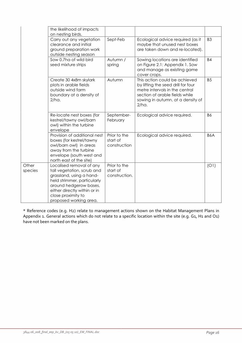
3844 06_008_final_eep_kv_DB_(05 05 10)_EM_FINAL.doc Page 16
the likelihood of impacts
on nesting birds.
Carry out any vegetation
clearance and initial
ground preparation work
outside nesting season
Sept-Feb Ecological advice required (as it
maybe that unused nest boxes
are taken down and re-located).
B3
Sow 0.7ha of wild bird
seed mixture strips
Autumn /
spring
Sowing locations are identified
on Figure 2.1: Appendix 1. Sow
and manage as existing game
cover crops.
B4
Create 30 4x8m skylark
plots in arable fields
outside wind farm
boundary at a density of
2/ha.
Autumn This action could be achieved
by lifting the seed drill for four
metre intervals in the central
section of arable fields while
sowing in autumn, at a density of
2/ha.
B5
Re-locate nest boxes (for
kestrel/tawny owl/barn
owl) within the turbine
envelope
September-
February
Ecological advice required. B6
Provision of additional nest
boxes (for kestrel/tawny
owl/barn owl) in areas
away from the turbine
envelope (south west and
north east of the site)
Prior to the
start of
construction
Ecological advice required. B6A
Other
species
Localised removal of any
tall vegetation, scrub and
grassland, using a hand-
held strimmer, particularly
around hedgerow bases,
either directly within or in
close proximity to
proposed working area.
Prior to the
start of
construction.
(O1)
* Reference codes (e.g. H2) relate to management actions shown on the Habitat Management Plans in
Appendix 1. General actions which do not relate to a specific location within the site (e.g. G1, H1 and O1)
have not been marked on the plans.

3844 06_008_final_eep_kv_DB_(05 05 10)_EM_FINAL.doc Page 17
Table 3. Ecological Management: Ongoing; See also Figure 2.2, Appendix 1.
Feature Ongoing Management Timing Details Ref*
Grassland Cutting of grassland
margins. This could be
done annually or,
wherever possible, once
every 2 years on rotation.
Mid-July
onwards
Cutting period scheduled to allow
plants to flower and avoid nesting
birds; allow formation of tussocks
and taller grassland in a 1-2m wide
uncut strip immediately adjacent
to hedge bases. This area should
be monitored for pernicious
weeds, which should be treated
by spot spraying.
G3
Hedgerows Trim hedgerows within the
site on rotation
Nov-Feb Each individual hedgerow cut
every three years to allow fruiting
and availability of nesting habitat.
(H3)
Annual checks of newly
planted hedgerow for
first three years;
replacement of dead
trees/shrubs and missing
tree guards
Nov – Mar Avoid periods of frost when
planting replacement trees
H4
Control of weeds around
trees/shrubs twice
annually during summer
months for first three
years
May -
August
H5
Field ponds Review establishment of
restored ponds
Spring 2011 Any additional management
requirements should be reviewed
following a site visit. Ecological
advice required.
P4
Review management
requirements of ponds
Spring
2014
Any additional management
requirements should be reviewed
following a site visit. Ecological
advice required.
P5
Ditches Maintain diverse
vegetation structure
along ditches
Mid
September-
late
February
D2
Beetle
Banks
Maintain beetle banks Autumn E2
Farmland
birds
Maintain wild bird seed
mixture strips
Autumn /
spring
B7
Maintain skylark plots
outside wind farm
boundary at a density of
2/ha.
Autumn This action could be achieved by
lifting the seed drill for four metre
intervals in the central section of
arable fields while sowing in
autumn.
B8
Maintain nest boxes
across the site
September-
February
Ecological advice required. B9
* Reference codes (e.g. G3) relate to management actions shown on the Habitat Management Plans in Appendix 1.
General actions which do not relate to a specific location within the site (e.g. H3) have not been marked on the plans.

3844 06_008_final_eep_kv_DB_(05 05 10)_EM_FINAL.doc Page 18
Appendix 1
Figure 1: Site Plan and Habitat Map
Figure 2.1 Ecological Management Prescriptions: Year 1
Figure 2.2 Ecological Management Prescriptions: Ongoing
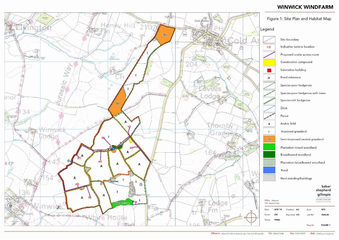


3844 06_008_final_eep_kv_DB_(05 05 10)_EM_FINAL.doc Page 19
Appendix 2: Planting / seed mix specifications
Recommended hedgerow species Percentage
Hawthorn Crataegus monogyna 70%
Blackthorn Prunus spinosa 10%
Field maple Acer campestre 5%
Hazel Corylus avellana 5%
Buckthorn Rhamnus catharticus 5%
Dogwood Cornus sanguinea 5%
100%
Recommended grassland mixture*
Grasses
(80%)
Herbs
(20%)
Red fescue Festuca rubra 40%
Crested dog's-tail Cynosurus cristatus 20%
Sheep's fescue Festuca ovina 30%
Smooth meadow grass Poa trivialis 10%
Bird’s-foot trefoil Lotus corniculatus 5%
Common vetch Vicia sativa 7%
Field scabious Knautia arvensis 7%
Lady's bedstraw Galium verum 12%
Common knapweed Centaurea nigra 12%
Meadow buttercup Ranunculus acris 4%
Musk mallow Malva moschata 10%
Oxeye daisy Leucanthemum vulgare 10%
Selfheal Prunella vulgaris 15%
White campion Silene latifolia 5%
Wild carrot Daucus carota 8%
Yarrow Achillea millefolium 5%
100% 100%
Grassland sowing rate - 3 to 4g/m2
* Mix based on a standard native
neutral grassland/field margin mixture.